Pacific Lamprey 2018 Regional - Implementation Plan for
←
→
Page content transcription
If your browser does not render page correctly, please read the page content below
Pacific Lamprey 2018 Regional
Implementation Plan for the
Snake River Region: Lower Snake,
Clearwater and Salmon Regional
Management Units

Submitted to the Conservation Team August 22, 2018
                                           Authors
Jody Brostrom – U.S. Fish and Wildlife Service   Kris Buelow – Snake River Salmon Recovery
                                                 Board
Eli Felts – Idaho Department of Fish and Game    Katherine Thompson – US Forest Service
Tim Copeland – Idaho Department of Fish and      Aaron Jackson – Confederated Tribes of the
Game                                             Umatilla Reservation
David Statler – Nez Perce Tribe                  Cynthia Tait, U.S. Forest Service
Benjamin Clemens, Oregon Department of Fish      Erin Butts – U.S. Fish and Wildlife Service
and Wildlife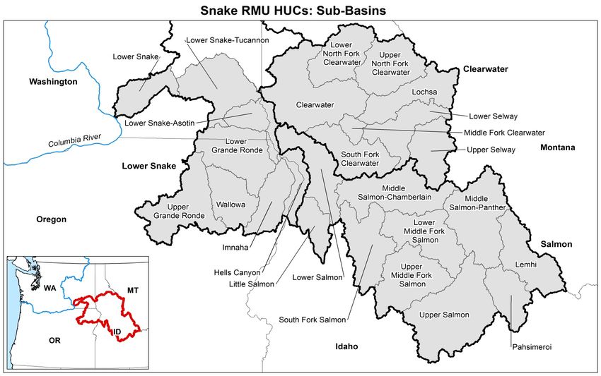
Projects proposed and discussed within this Regional Implementation Plan are in accordance
with direction provided within the Conservation Agreement for Pacific Lamprey in the States of
Alaska, Washington, Idaho, Oregon and California, 2012. Cooperative efforts through the
Agreement intend to: a) develop regional implementation plans derived from existing
information and plans; b) implement conservation actions; c) promote scientific research; and d)
monitor and evaluate the effectiveness of those actions.
Projects identified in this Regional Implementation Plan do not imply or intend a funding
obligation or any related activity from any of the government agencies, tribes or non-
governmental entities discussed within this document.
I. Status and Distribution of Pacific Lamprey in the RMU
A. General Description of the RMU
The Snake River Region includes the Snake River and all waters draining into it downstream
of Hells Canyon Dam (river km 397) to its confluence with the Columbia River (Figure 1).
There are three Regional Management Units (RMUs): the Lower Snake Basin, the
Clearwater River Basin, and the Salmon River Basin (Figure 1) with five major tributaries:
Imnaha, Salmon, Grande Ronde, Clearwater, and Tucannon rivers. Within these RMUs there
are 23 Hydrologic Unit Code (HUC) 4 subbasins. The watersheds within this region that are
still accessible to Pacific Lamprey range in size from 552-6,242 km2.
The HUC 4 subbasins include: Lower Clearwater (17060306), Middle Fork Clearwater
(#17060304), South Fork Clearwater (#17060305), Lochsa (#17060303), Lower Selway
(#17060302), Upper Selway (#17060301). Lower Salmon (#17060209), Little Salmon
(#17060210), South Fork Salmon (#17060208). Middle Salmon-Chamberlain (#17060207),
Lower Middle Fork Salmon (#17060206), Upper Middle Fork Salmon (#17030505), Middle
Salmon-Panther (#17060203), Lemhi (#17060204), Pahsimeroi (#17060202), Upper Salmon
(#17060201); Lower Snake-Asotin (17060103), Lower Grande Ronde (#170602105), Upper
Grande Ronde (#17060104), Wallowa (#17060105), Mainstem Snake Hells Canyon
(#17060101), and Lower Snake Tucannon (#17060107).
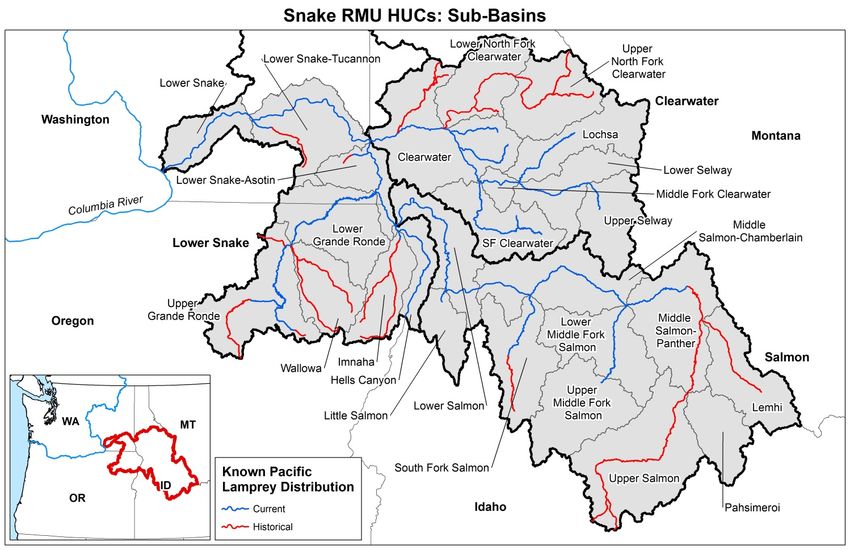
Figure 1. Map of 4th Code watersheds within the Snake River Region.
Snake River Region Draft RIP for Lower Snake, Clearwater and Salmon RMUs 2018 1B. Status of Species Conservation Assessment and New Updates Historic occupancy of Pacific Lamprey is believed to have been extensive in all watersheds depicted in Figure 2 as well as the Snake River up to Shoshone Falls, and all major tributaries between the Hells Canyon Dam Complex and Shoshone Falls (Weiser River, Payette River, Bruneau River). Current population size is still unknown in most areas of historic occupancy, but the current distribution was assessed to be reduced from historic ranges (Luzier et al. 2011) with revisions in 2018 (Table 17-x USFWS 2018 draft). Recently changes to known presence of lamprey in the Snake River have been significantly affected by an active supplementation program ongoing by the Nez Perce Tribe (NPT) whereby adult lamprey collected from locations downstream in the Columbia River are released into Snake basin tributaries. The current information describing known occurrences of Pacific Lamprey is displayed in Figure 2 a product of the U.S. Fish and Wildlife Service (USFWS) data Clearinghouse https://www.sciencebase.gov/catalog/item/53ad8d9de4b0729c15418232). Figure 2. Current and historic known distribution for Pacific Lamprey in the Snake Regional Management Units: Lower Snake, Clearwater and Salmon (USFWS Data Clearinghouse 2018). Snake River Region Draft RIP for Lower Snake, Clearwater and Salmon RMUs 2018 2
Distribution and Connectivity
Passage to the Snake River Region is restricted downstream by four Federal Columbia River Power
System (FCRPS) dams in the mainstem Columbia River (Bonneville, Dalles, John Day and McNary).
Within the Snake River Region another four FCRPS dams on the mainstem Snake River impede
passage in the lower portion (Ice Harbor, Lower Monumental, Little Goose and Lower Granite). The
Hells Canyon Complex (Brownlee, Oxbow and Hells Canyon) on the Snake River as well as
Dworshak Dam on the North Fork Clearwater River have permanently blocked upstream access for
all native aquatic species. Culverts, irrigation diversions and smaller dams are widespread throughout
the watersheds of the Snake River Region.
The combined impacts from this series of passage impediments are the most significant impact on the
natural distribution and connectivity for Pacific Lampreys in most of the HUCs. Recent (since 1996)
annual counts of adult lamprey at Ice Harbor Dam are low, ranging from 5 to 1,702 with even fewer
adults seen at Lower Granite Dam (Figure 3).

                        Number of Adult Lamprey Counted at
                         Lower Snake River dams 1996-2017
 1800

 1600

 1400

 1200

 1000                                                                             Ice Harbor
                                                                                  Lower Monumental
  800
                                                                                  Little Goose
                                                                                  Lower Granite
  600

  400

  200

     0
         1996
         1997
         1998
         1999
         2000
         2001
         2002
         2003
         2004
         2005
         2006
         2007
         2008
         2009
         2010
         2011
         2012
         2013
         2014
         2015
         2016
         2017

Figure 3. Number of adult Pacific Lamprey counted at Lower Snake River Dams, 1996-2017. Data
obtained from http://www.cbr.washington.edu/dart on July 11, 2018.

Snake River Region Draft RIP for Lower Snake, Clearwater and Salmon RMUs   2018                      3
Stream surveys conducted in the Clearwater River 2000 to 2002 (Cochnauer and Claire 2009)
reported that larval Pacific Lamprey were present in the mainstem and Middle Fork Clearwater River
up to and including the Lochsa and Selway rivers, in the South Fork Clearwater River and in the Red
River but not American or other tributaries of the South Fork Clearwater River. Similar surveys
conducted in the Salmon River 2006 confirmed the presence of larval Pacific Lamprey in the
mainstem Salmon River downstream of the North Fork Salmon River and in the lower segment of the
Middle Fork Salmon River but in no other tributaries or segments of the Salmon River upstream of
the North Fork (IDFG 2011). This section of the Salmon River was surveyed again in 2017 and larval
Pacific Lamprey were detected at low relative abundance at all 13 sites surveyed (E. Felts, IDFG,
pers. com). Recent (2015-2017) surveys have confirmed the continued presence of larval lamprey in
the Mainstem, Middle and South forks of the Clearwater River and Lochsa and Selway rivers but
lamprey are no longer present in the Red River of the South Fork Clearwater River (C. Peery,
USFWS, pers. com.). In eastern Oregon, larval Pacific Lamprey were found in the Minam and
Wallowa rivers during 2015 surveys (C. Peery, USFWS, pers. com.).
Beginning in 2007, the NPT began releasing adult Pacific Lamprey, collected from downstream areas
in the Columbia River, into tributaries of the Snake River as a means to supplement natural
production (Table 1; see Ward et al. 2012). Subsequent stream surveys confirmed the presence of
larval lamprey in locations receiving adult lamprey but had previously not contained larval or
juvenile lamprey in recent years. These sites include Lolo, Orofino, and Newsome creeks in the
Clearwater River, Asotin Creek, the South Fork Salmon River and Wallowa River. In 2015 the
Confederated Tribes of the Umatilla Reservation initiated releases into the Upper Grande Ronde
River and it’s tributaries (Table 1).
C. Threats
Summary of Major Treats
The highest priority threat in the Snake River Region is the Federal Columbia River Power System
dams on the mainstem Snake and Columbia rivers, which results in small effective population size in
each of the watersheds still accessible to Pacific Lamprey (USFWS 2018 draft). Table 2 summarizes
the known key threats that ranked Medium and High within the Snake River Region tributaries (H –
High, M – Medium, L – Low, I – Insignificant). The Supplement to the Mainstem Lower Columbia
River and Columbia River Estuary Subbasin Plan (NPCC 2004) in Strategy to Protect and Restore
Habitat; recommends to improve dam passage for Pacific lamprey. Translocation is now called
Supplementation, to better represent the range of actions that occur when Pacific Lamprey are moved
from one place to another.
New Threats
No new threats have been identified since 2011 (USFWS 2018 draft)
Snake River Region Draft RIP for Lower Snake, Clearwater and Salmon RMUs 2018 4Table 1. Releases of adult Pacific Lamprey into the Clearwater, Salmon, Grande Ronde and Asotin
subbasins, 2007-2018, as part of the Nez Perce Tribe (NPT) and Confederated Tribes of the Umatilla
Reservation (CTUIR) translocation program. Asterisk denotes CTUIR releases. Data supplied by the
Nez Perce Tribe and The Confederated Tribes of the Umatilla Reservation.
Year
2007 2008 2009 2010 2011 2012 2013 2014 2015 2016 2017 2018 Total
Clearwater River (ID)
Lolo Cr. 50 28 30 24 0 40 31 10 50 57 65 90 475
Newsome Cr. 50 26 45 23 0 40 30 10 50 56 61 95 486
Orofino Cr. 49 25 30 22 0 40 24 0 51 56 0 90 387
Little Canyon Cr. 0 0 0 0 0 17 12 0 32 41 0 0 102
Red R. 0 0 0 0 0 0 0 0 0 0 0 91 92
Subbasin Total 149 79 105 69 0 137 97 20 183 210 126 366 1542
Salmon River (ID)
South Fork Salmon R. 0 0 0 0 0 40 30 11 50 56 62 90 339
Johnson Cr. 0 0 0 0 0 0 0 0 51 48 60 89 248
Secesh R. 0 0 0 0 0 0 0 0 0 50 65 90 205
Subbasin Total 0 0 0 0 0 40 30 11 101 154 187 269 792
Snake-Asotin (WA)
Asotin Cr. 28 27 35 22 29 40 30 10 43 56 61 90 471
Grande Ronde River (OR)
Minam R. 0 0 0 0 0 0 0 0 25 55 35 90 205
Wallowa R. 0 0 0 0 0 40 30 10 25 55 30 90 280
Chesnimnus Cr (Joseph Cr) 0 0 0 0 0 0 0 0 0 56 64 90 210
Catherine Cr. 0 0 0 0 0 0 0 0 0 167 250 212 629
*Upper Grande Ronde R. 0 0 0 0 0 0 0 0 0 400 201 527 1128
*Lookingglass Cr. 0 0 0 0 0 0 0 0 0 175 150 151 476
*Little Lookingglass Cr. 0 0 0 0 0 0 0 0 0 0 150 0 150
*Indian Cr. 0 0 0 0 0 0 0 0 0 0 0 92 92
*Meadow Cr. 0 0 0 0 0 0 0 0 0 0 0 82 82
*Sheep Cr. 0 0 0 0 0 0 0 0 0 0 0 82 82
Subbasin Total 0 0 0 0 0 40 30 10 50 908 880 1416 3334
Total Snake River Region 177 106 140 91 29 257 187 51 377 1328 1254 2141 6139
Snake River Region Draft RIP for Lower Snake, Clearwater and Salmon RMUs 2018 5Table 2. Summary of the identified key threats of the Snake River Region, by RMU and Watershed, 2018. Harvest, Predation,
Supplementation (formerly Translocation), Disease, Lack of Awareness and Climate Change were assessed and ranked Low or Insignificant
in most HUC’s.
Mainstem Small Tributary Dewatering Stream and Water Lack of Climate Predation
Passage Population Passage and Flow Floodplain Quality Awareness Change
RMU/Watershed Size Management Degradation
Lower Snake RMU H H M L M L H M L
Lower Snake-Asotin H H L L M M H H M
Lower Grande Ronde H H L I L L H H L
Upper Grande Ronde H H M M H M H M L
Imnaha H H M M H M H M L
Wallowa H H M M M M H M M
Lower Snake-Hells Canyon H H M M L L M M M
Lower Snake-Tucannon H H M L M M H M L
Clearwater RMU H H L I L L L L I
Lower Clearwater H H L L M M M M L
Middle Fork Clearwater H H L L L L M L L
South Fork Clearwater H H L L M L M L L
Lochsa H H L I L I L I I
Lower Selway H H I I I I L L I
Upper Selway H H I I I I L I I
Salmon RMU H H L L L L M L L
Lower Salmon H H L L L L M L L
Little Salmon H H L L L M M L L
South Fork Salmon H H L I L L M L L
Middle Salmon-Chamberlain H H I I L L M L L
Lower Middle Fork Salmon H H I I I I L I I
Upper Middle Fork Salmon H H I I I I L I I
Middle Salmon-Panther H H M M M L M L I
Lemhi H H M M M M M L I
Pahsimeroi H H M M M L M I I
Upper Salmon H H L L M L M I I
Snake River Region Draft RIP for Lower Snake, Clearwater and Salmon RMUs 2018 6D. Restoration Actions
Ongoing or planned restoration efforts in the Snake Basin are intended to improve anadromous and
native resident salmonid production and connectivity. These projects will also benefit Pacific
Lamprey but as lamprey production is primarily limited by low escapement, habitat improvement
projects will have limited effect on Snake River lamprey population in the near future. Recovery of
Pacific Lamprey in the Snake River will instead depend on actions taken within the Columbia and
Snake rivers mainstem regional implementation plans. In the near term, translocation of adult Pacific
Lamprey into Snake River sub-basins, coordinated stream monitoring for larval lamprey and target
restoration efforts will comprise restoration actions. Actions that have been completed or are ongoing
are in Table 3.
Table 3. Conservation actions specifically for or substantially benefitting lampreys that were initiated
or completed in the Snake RMU from 2012-2017.
HUC Threat Action Description Type Status
RMU Population Environmental DNA, smolt trapping and Survey Ongoing
occupancy sampling to better understand
lamprey distribution.
Upper and Population Oregon DFW drafting a conservation plan for 4 Assessment Ongoing
Lower Grande species of lampreys.
Ronde
Clearwater Population Translocation of adult Pacific Lamprey in Little Instream Ongoing
Canyon, Orofino and Lolo creeks. (NPT)
South Fork Population Translocation of adult Pacific Lamprey in Instream Ongoing
Clearwater Newsome Creek. (NPT)
South Fork Population Translocation of adult Pacific Lamprey in Instream Ongoing
Salmon South Fork Salmon River and Johnson Creek.
(NPT)
Lower Grande Population Translocation of adult Pacific Lamprey in Instream Ongoing
Ronde Wallowa River and Minam Creek. (NPT)
Upper Grande Population Translocation of adult Pacific Lamprey in Instream Ongoing
Ronde Upper Grande Ronde River and Catherine
Creek. (CTUIR)
Lower Snake- Population Translocation of adult Pacific Lamprey in Instream Ongoing
Asotin Asotin Creek. (NPT)
South Fork Passage Aquatic Organism Passage restoration in Instream Complete
Clearwater American River. The project improved access
to 10+ miles of potential lamprey habitat.
South Fork Stream and Over 3 miles of channel reconstruction and Instream Ongoing
Clearwater Floodplain riparian restoration in a previously dredged
mine section of Newsome Creek
South Fork Stream and Three miles of stream and riparian area in Red Instream Completed
Clearwater Floodplain River were restored from conditions created
with past dredge mining activity.
South Fork Stream and Over three miles of stream and riparian area in Instream Ongoing
Clearwater Floodplain Crooked River are being restored from impacts
of past dredge mining activity.
Lower Stream and One mile of stream in the Collette Mine area of Instream Ongoing
Clearwater Floodplain Lolo Creek is being reconstructed and the
floodplain restored.
Snake River Region Draft RIP for Lower Snake, Clearwater and Salmon RMUs 2018 7E. High Priority Proposed, Implemented or Funded Project Information:
Prioritization Process
The highest priority threat for Snake River Region RMU’s is mainstem passage in the Snake and
Columbia rivers. The four proposed projects below are stakeholder priorities, as they are beneficial
to, and increase our understanding of, populations. There has not been an attempt to prioritize one
over the other. The two Translocation projects are meant to complement each other, and it is
expected that the project proponents will coordinate so that efforts are not duplicated.
Proposal from RIP / RMU to the Conservation Team Reviewer’s
Category
Translocating Lamprey Past Snake River Dams Score
2, 1, 0
Project Rationale:
In response to the dire status and extirpation trend of Pacific lamprey in the Snake Basin, and the
association of this downturn to passage at mainstem Columbia/Snake River Dams, the Nez Perce
Tribe Department of Fisheries Resources Management (NPTDFRM) began an adult Pacific
lamprey translocation initiative in 2006. The NPTDFRM translocation effort consists of
obtaining adult lamprey from the lower Columbia River dams (Bonneville, The Dalles and John
Day) and transporting them upstream past the dams to the Nez Perce Tribal Hatchery (NPTH),
located on the Nez Perce Reservation within the Clearwater Subbasin of the Snake River. The
adult lamprey over-winter at NPTH and are released the following spring, typically mid- to late-
May, into Snake Basin streams.
Translocation is specifically identified in the Columbia River Inter-Tribal Fish Commission
(CRITFC) Tribal Pacific Lamprey Restoration Plan (2011). The NPT considers adult
translocation an emergency stop-gap measure, and perhaps the only immediately available
management tool, to partially address the limiting factor of adult mainstem passage and the threat
to their continued existence that the mainstem dams pose.
The purposes of the translocation initiative are to:
• Maintain some level of production in the Snake Basin until mainstem passage improves
• Thwart further local extirpations
• Prevent loss of pheromone migration cues to migrating adults from larval lamprey
• Restore lamprey related ecosystem values to promote diversity, productivity and
ecosystem health
• Preserve cultural values associated with lamprey.
Larval (ammocoete) and juvenile (macrophthalmia) are sampled in translocation and non-
translocation streams to gauge effectiveness of the translocation actions. In coordination with the
CRITFC Hagerman Genetics Laboratory, Hagerman, Idaho, parentage analysis is conducted for
samples collected via electro-fishing and rotary screw trapping.
• Please provide NPCC Subbasin name and Watershed 6th or 5th Field HUC;
o Clearwater (#17060306) HUC 4 Subbasin
o Middle Fork Clearwater (#17060304) HUC 4 Subbasin
o Lower Selway (#17060302) HUC 4 Subbasin
Snake River Region Draft RIP for Lower Snake, Clearwater and Salmon RMUs 2018 8o Lochsa (#17060303) HUC 4 Subbasin
o Lower Salmon (#17060209) HUC 4 Subbasin
o South Fork Salmon (#17060208) HUC 4 Subbasin
o Lower Middle Fork Salmon (#17060206) HUC 4 Subbasin
o Lower Snake (#17060107) HUC 4 Subbasin
o Lower Snake-Asotin (#17060103) HUC 4 Subbasin
o Hells Canyon (#17060101) HUC 4 Subbasin
o Imnaha (#17060102) HUC 4 Subbasin)
o Wallowa (#17060105) HUC 4 Subbasin
o Lower Grande Ronde (#17060106) Subbasin
o Upper Grande Ronde (#17060104) Subbasin
o Middle Columbia-Hood (#17070105) Subbasin
o Middle Columbia-Lake Wallula (#17070101) Subbasin
• Land ownership, regulatory responsibilities.
The Columbia River mainstem dams (Bonneville, The Dalles and John Day) from which
adult Pacific lamprey will be collected and transported for translocation are owned by the
Federal government, U.S. Army Corps of Engineers.
The Nez Perce Tribal Hatchery, Lenore, Idaho, where the translocated lamprey overwinter, is
owned by the Nez Perce Tribe.
In Idaho, streams to which adult lamprey will be translocated are located primarily within
National Forests. In Oregon and Washington, streams to which adult lamprey will be
translocated primarily cross private lands.
• What Lamprey RMU population or portion of the river will benefit from action?
The Snake River RMU will benefit from this action.
• What is the RMU HUC4 risk level?
Based on the USFWS 2011 Pacific Lamprey (Entosphenus tridentatus) Assessment and
Template for Conservation Measures, populations within all 4th Field Hydrologic Unit Codes
(HUCs) in the Snake River RMU are ranked either presumed extirpated, possibly extirpated
or critically imperiled. A follow-up USFWS five rear re-assessment reported an increase in
numbers of Pacific lamprey larvae in translocation streams
• What life stage or stages that will benefit from action? How?
Adults – Migration and spawning - The NPTDFRM has been releasing translocated adult
lamprey into Snake Basin streams since 2007. Successful spawning of translocated adult
lamprey has been verified by parentage analysis for translocation streams.
Larvae – Distribution and numbers of Pacific lamprey larvae per stream have increased as a
result of adult translocation in the Snake Basin. Increased presence of larvae further the
goals of augmenting Pacific lamprey production until such time as volitional migration
through the mainstem substantively improves, thwarts further local extirpations, prevents
loss of pheromone migration cues to migrating adults from larval lamprey, adds to the
distribution data base, and restores lamprey related ecosystem values to promote diversity,
productivity and ecosystem health.
Macrophthalmia – Parent-based tagging has documented macrophthalmia production from
Snake River Region Draft RIP for Lower Snake, Clearwater and Salmon RMUs 2018 9translocated adults released in Snake Basin streams.
• What other species may benefit from action?
Translocated adults and their progeny reestablish the presence of Pacific Lamprey in streams
previously devoid of lamprey. Improved associated ecosystem values include the influx of
marine derived nutrients and increased conversion of detritus based energy to biomass
assessable as food for a host of aquatic life, including bull trout, cutthroat trout, steelhead and
salmon.
• How will the project provide meaningful and measureable results to improve lamprey
populations and/or their habitat conditions?
The project leverages efforts among cooperating entities, including the Columbia River Inter-
Tribal Fish Commission, US Fish and Wildlife Service, US Forest Service and various Nez
Perce Tribe fisheries staff to conduct parentage analysis and parentage-based tagging. This
effort documents and measures production from translocated adult lamprey and provides
valuable life history data, including larval distribution, length at age of larvae, length at age
of macrophthalmia, , age at emigration from natal streams, and size and age of
macrophthalmia at various migration points, and relative production of translocated vs.
volitional migrated adults.
• Does the action specifically address the Lamprey Strategy and Measures as defined in
the 2014 F&W Program? (Specific to BPA Cost Savings $)
Yes, the action addresses the following:
The Northwest Power and Conservation Council, consistent with the Lamprey Strategy and
Measures as defined in the 2014 F & W Program approved for funding the Pacific Lamprey
Conservation Initiative Columbia River Basin Projects. This project is facilitated by the
USFWS and administered through Pacific States Marine Fisheries Commission (PSFMC).
Restoration actions in the appropriate RMU’s are reviewed and selected by the Agreement
Conservation Team based on the following criteria as outlined in the Pacific Lamprey
Conservation Agreement Operating Guidelines;
1. Project Rationale
2. Linkage of Actions to Threats
3. Project Feasibility
4. Partner Engagement and Support
5. Monitoring and Evaluation – Contribution to Knowledge Gaps
6. Budget and Timelines
The Agreement Conservation Team’s selection criteria are consistent with those of the
Council in regard to whether they:
1. Are based on sound science principles;
2. Benefit fish and wildlife;
3. Have clearly defined objectives and outcomes; and
4. Have provisions for monitoring and evaluation of results.
Linkage of Actions to Threats:
• What threat(s) does this project address?
Mainstem passage. Mainstem passage has been identified as the most serious limiting factor
Snake River Region Draft RIP for Lower Snake, Clearwater and Salmon RMUs 2018 10affecting Pacific lamprey in the Snake Basin, with mainstem dams being the most serious
threat (Luzier et al. 2011).
• How does the project address this key threat(s)?
Translocation Lamprey Past Snake River Dams bypasses the serious passage problems at the
dams via collection and transport. This avoids the loss of, on average, 50% of migrating adult
lamprey, per dam. Transported adult lamprey overwinter at the Nez Perce tribal Hatchery and
are released the following year into Snake basin streams. The intent is to maximize
productive success of translocated adults.
• Does this project address a threat(s) specific only to this RMU or does the project address the
threat(s) for multiple RMUs?
This project addresses adult Pacific Lamprey mainstem passage problems specific to the
Snake Basin. Other translocation programs in their respective RMUs address mainstem
passage problems posed by dams.
Project Feasibility:
• Have the designs for the project been completed already or will they be completed before
planned project implementation (within the period of performance)?
• Designs for the project have been completed.
The NPTDFRM has been releasing translocated adult lamprey into Snake Basin streams
since 2007. Successful spawning of translocated lamprey has been verified by parentage
analysis for all translocation streams. Parentage analyses has also provided valuable life
history data, such as lengths at age, ages of ammocoetes and macrophthalmia, and age at
emigration from the natal stream. Translocation into Snake Basin streams is expected to
continue, adding new translocation streams within the Snake Basin, with broader and more
intensive larval assessments of translocation and non-translocation streams. This will further
the goals of augmenting Pacific lamprey production until such time as volitional migration
through the mainstem substantively improves, thwart further local extirpations, prevent loss
of pheromone migration cues to migrating adults from larval lamprey, add to the distribution
data base, and restore lamprey related ecosystem values to promote diversity, productivity
and ecosystem health
• Are the appropriate permits (ESA and environmental compliance) in place already or will they
be in place before planned project implementation (within the period of performance)?
Yes.
• Can the project be implemented within the defined time frame?
Yes.
Partner Engagement and Support:
• What partners are supporting the project?
Coordination with relevant stakeholders has been and is expected to continue to be very
good. Partners include: the U.S. Fish and Wildlife Service, U.S. Army Corps of Engineers,
CRITFC, Bonneville Power Administration, University of Idaho, Idaho Department of Fish
and Game, Oregon Department of Fish and Wildlife and Asotin County Public Utility
District.
• What partners are actively in implementing the project?
US Fish and Wildlife Service, US Army Corps of Engineers, US Forest Service (eDNA) and
Columbia River Inter-Tribal Fish Commission.
• What partners are providing matching funds or in-kind services that directly contribute to this
project?
Nez Perce Tribe, CRITFC and US Fish and Wildlife Service.
• Are the partners able to contribute to the proposed project in a timely and appropriate manner?
Snake River Region Draft RIP for Lower Snake, Clearwater and Salmon RMUs 2018 11Yes.
• Does this action link to other projects in the watershed?
Yes. The action links to Implement Tribal Pacific Lamprey Restoration Plan, NPT Lolo
Creek Watershed Restoration, Newsome Creek Watershed Restoration, American River
Watershed Restoration, Crooked River Watershed Restoration, Red River Watershed
Restoration, South Fork Salmon River Watershed Restoration and other watershed restoration
efforts.
Monitoring and Evaluation - Contribution to Knowledge Gaps:
• If this is a monitoring or evaluation project or an on the ground project with a monitoring or
evaluation component:
• Is there a monitoring framework in the proposal?
Yes. This proposal is supported by a monitoring framework contained in the Nez Perce tribe
Pacific Lamprey Translocation and Assessment project and the CRITFC Larval Lamprey
Surveys in the Snake River Basin project.
• Does the monitoring framework provide clear objectives and measureable metrics that can be
observed over time?
Yes.
• Does the framework provide a clear description of the expected outcome?
Yes.
• Does the framework provide a clear description of the expected outcome?
Yes.
• If this is an on the ground project without a monitoring or evaluation component:
No.
o How is completion of the project going to be documented? N/A.
o Is this project’s effectiveness linked to another M&E project? N/A.
Budget and Timelines:
• Is the budget within the guidelines provided by the Conservation Team (project maximum
budget is $100,000) (Specific to BPA Cost Savings $)?
Yes.
• Is there a detailed budget describing personnel, equipment and supplies, travel, publication,
overhead needs?
Yes.
• Does the project describe a reasonable and feasible approach for the project to be completed
within the performance period and within budget?
Yes.
• Does the proposal demonstrate meaningful cost share (cash, equipment, labor)?
Yes.
Total
2 = Fully Meets Criteria
1 = Needs Some Additional Information
0 = Insufficient
Proposed and ongoing: Stream Surveys for Larval Lamprey
Associated with the adult translocation program, stream surveys have been conducted to document
the presence of larval lamprey in both the streams that have received adult lamprey and nearby
streams that would presumably contain only natural production. Surveys are being jointly conducted
by the NPT and the USFWS. To date, surveys have been conducted in the Clearwater, Salmon and
Snake River Region Draft RIP for Lower Snake, Clearwater and Salmon RMUs 2018 12Grande Ronde rivers and tributaries of the lower Snake River (see Figure 2 for current presence data). Information is added to the regional database tracking lamprey distribution and abundance. The Idaho Department of Fish and Game (IDFG) monitors Pacific Lamprey larval distribution in both streams that are presumed to contain natural production and those which may be influenced by the adult translocation programs. Currently, distribution is monitored by electrofishing surveys which are most often conducted during wilderness float trips. Biologists have used the results of recent opportunistic sampling to establish index sites which will be surveyed during each float trip within a given drainage, and will randomly select additional roving sites on future float trips. In addition to standard electrofishing surveys conducted on wilderness float trips IDFG is currently evaluating sampling efficiency of three different electrofishing protocols. These protocols include two types of electrofishing units: 1) ETS model AbP-2 “Wisconsin” electrofisher, and 2) Smith-Root LR-24 model electrofisher. Electrofisher setting for ammocoete sampling include two wave forms: 1) a low frequency wave to draw ammocoetes out of substrate, and 2) a high frequency wave form to immobilize ammocoetes once drawn out of the substrate. Two protocols using the Smith-Root LR-24 electrofisher are being evaluated, one which uses a standard setup with a single anode pole and a “rat- tail” and a second which uses dual anode poles. These three electrofishing protocols were implemented across 21 sites on the Selway River in 2018, with protocols being randomly selected across sites. Additional sites will be surveyed prior to analysis of sampling efficiency, and results will ultimately be used to recommend standard electrofishing survey methods which maximize efficiency. Monitoring activities associated with salmonid monitoring bring IDFG staff to many locations throughout Idaho which, if surveyed, could add to understanding of Pacific Lamprey distribution and the effects of the adult translocation program within Idaho. However, IDFG currently has no funding to conduct Pacific Lamprey monitoring. Environmental DNA (eDNA) sampling for Pacific Lamprey is currently being researched and refined by the United States Forest Service Rocky Mountain Research Station, and offers the opportunity to monitor distribution with minimal time investment. This method, along with established electrofishing methods, could be implemented by IDFG staff conducting salmonid monitoring if funding were available. Additional monitoring would involve collaboration of NPT, IDFG and USFWS. Partners would work together to select sampling locations in a manner which would contribute to further evaluation of the adult translocation program and improve assessment of Pacific Lamprey status in Idaho. Stakeholders will explore the efficacy and details for developing eDNA sampling and processing methods and protocol to facilitate low-cost observations of lamprey distribution. As other eDNA projects are likely to be proposed in other RMU’s, stakeholders will coordinate within the region so methods are consistent and replicable with other areas. Snake River Region Draft RIP for Lower Snake, Clearwater and Salmon RMUs 2018 13
References
Cochnauer, T. and C. Claire 2009. Evaluate Status of Pacific Lamprey in the Clearwater River and
   Salmon River Drainages, Idaho. Prepared for the Bonneville Power Administration Project
   Number 2000-028-00 Contract Number 00000090-00001. Document ID #P111657.
IDFG (Idaho Department of Fish and Game). 2011. The status of Pacific lamprey (Entosphenus
   tridentatus) in Idaho. Final Report.
Luzier, C.W., H.A. Schaller, J.K. Brostrom, C. Cook-Tabor, D.H. Goodman, R.D. Nelle, K. Ostrand
   and B. Streif. 2011. Pacific Lamprey (Entosphenus tridentatus) Assessment and Template for
   Conservation Measures. U.S. Fish and Wildlife Service, Portland, Oregon. 282 pp.
   http://www.fws.gov/columbiariver/publications.html
NPCC (Northwest Power and Conservation Council). 2004. Lower Columbia Salmon and Steelhead
  Recovery and Subbasin Plan.
  http://www.nwcouncil.org/fw/subbasinplanning/lowerColumbia/plan
NPCC (Northwest Power and Conservation Council). 2004. Supplement to the Mainstem Lower
  Columbia River and Columbia River Estuary Subbasin Plan. Prepared for the NPCC by the
  Lower Columbia River Estuary Partnership.
  http://www.nwcouncil.org/media/21259/Supplement.pdf
NPCC (Northwest Power and Conservation Council). 2009. Columbia River basin fish and wildlife
  program. Council Document 2009-02. http://www.nwcouncil.org/library/2009/2009-02.htm
USFWS. 2018. Assessment
Ward, D.L., B. Clemens, D. Clugston, A. Jackson, M. Moser, C. Peery, and D. Statler. 2012.
  Translocating Adult Pacific Lamprey within the Columbia River Basin: State of the Science.
  Fisheries 37:351-361.

Snake River Region Draft RIP for Lower Snake, Clearwater and Salmon RMUs   2018                    14
You can also read