Palmerston North Regional Freight Hub - Assessment of Ecological Values and Effects Prepared for KiwiRail Holdings Ltd 22 October 2020
←
→
Page content transcription
If your browser does not render page correctly, please read the page content below
Palmerston North Regional Freight
                             Hub
          Assessment of Ecological Values and Effects
                    Prepared for KiwiRail Holdings Ltd

                                     22 October 2020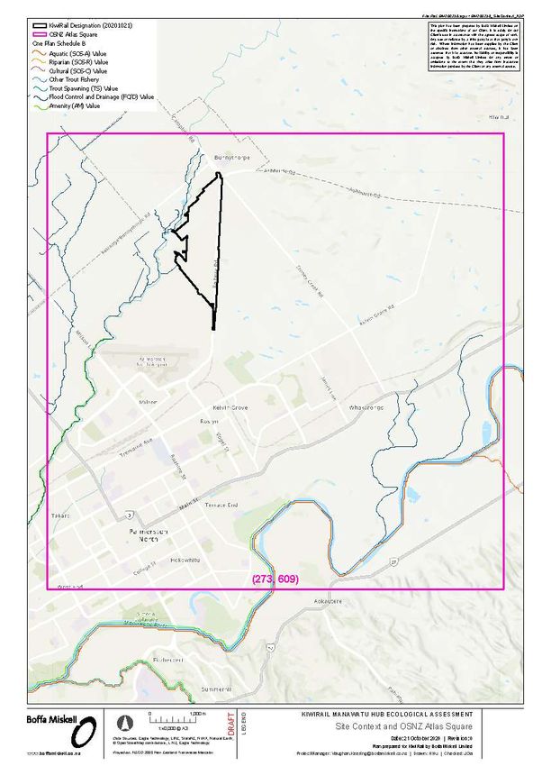
Document Quality Assurance

 Bibliographic reference for citation:
 Boffa Miskell Limited 2020. Palmerston North Regional Freight Hub: Assessment of Ecological
 Values and Effects. Report prepared by Boffa Miskell Limited for KiwiRail Holdings Ltd.

 Prepared by:                            Jeremy Garrett-Walker
                                         Ecologist
                                         Boffa Miskell Limited

 Reviewed by:                            Dr Vaughan Keesing
                                         Senior Ecologist
                                         Boffa Miskell Limited

 Status: Final                           Revision / version: 6                                        Issue date: 22 October 2020

 Use and Reliance
 This report has been prepared by Boffa Miskell Limited on the specific instructions of our Client. It is solely for our Client’s use for the
 purpose for which it is intended in accordance with the agreed scope of work. Boffa Miskell does not accept any liability or responsibility in
 relation to the use of this report contrary to the above, or to any person other than the Client. Any use or reliance by a third party is at that
 party's own risk. Where information has been supplied by the Client or obtained from other external sources, it has been assumed that it is
 accurate, without independent verification, unless otherwise indicated. No liability or responsibility is accepted by Boffa Miskell Limited for
 any errors or omissions to the extent that they arise from inaccurate information provided by the Client or any external source.

Template revision: 20180621 0000

File ref: 4200369 Technical Assessment - Ecology - v6.docx

Cover photograph: Central section of the northern tributary of stream system 1© Boffa Miskell Ltd, 2020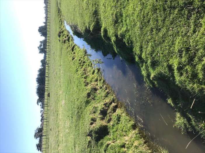
CONTENTS
1.0    Executive Summary                                                                   1
2.0    Introduction                                                                        3
       2.1    The Project                                                                  3
       2.2    Scope of assessment                                                          5
       2.3    Definitions used in this report                                              5
3.0    Methods of Assessment                                                               5
       3.1    Assessing ecological values                                                  5
       3.2    Desktop investigation                                                        7
       3.3    Field surveys                                                                8
4.0    Description of Existing Environment                                                10
       4.1    Site context                                                                10
       4.2    Terrestrial environment                                                     10
       4.3    Aquatic environment                                                         14
       4.4    Aquatic fauna                                                               19
       4.5    Macroinvertebrate community                                                 20
5.0    Ecological values                                                                  20
       5.1    Terrestrial environment                                                     20
       5.2    Aquatic environment                                                         22
       5.3    National and Regional Policy Documents                                      25
       5.4    Summary of ecological values on site                                        25
6.0    Assessment of potential ecological effects                                         26
       6.1    Vegetation clearance & Loss of avifauna and herpetofauna
              habitat                                                                     27
       6.2    Stream loss                                                                 27
       6.3    Summary of overall level of effects                                         31
7.0    Recommendations                                                                    31
       7.1    Terrestrial environment                                                     31
       7.2    Stream environment                                                          32
       7.3    Summary of recommendations                                                  32
8.0    References                                                                         33

U:\2020\BM200256_VKe_Kiwi_Rail_Manawatu_Hub_Ecological_Assessment\Documents\Version 4 -
final\4200369 Technical Assessment - Ecology - v6.docx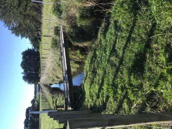
1.0 Executive Summary

This assessment considers the potential ecological effects of the proposed KiwiRail Freight Hub
(Freight Hub) between Palmerston North and Bunnythorpe, immediately west of Railway Road.

Project Description
The project will involve the construction and operation of a new Freight Hub, including associated
infrastructure (e.g. marshalling yards, container terminal, and stormwater treatment devices).
KiwiRail is seeking to enable works through a designation. A detailed design of the Freight Hub will
follow this process, along with the process of obtaining any relevant regional resource consents.
The Designation Extent is currently comprised primarily of pasture grasses (Charlton & Stewart,
1999), with some small areas of exotic vegetation (e.g. pine shelterbelts), and includes two
tributary systems of the Mangaone Stream catchment which pass through the Designation Extent.

Methods

    •   A range of desktop and field investigations were used to describe the terrestrial and
        freshwater environments present within the Designation Extent.

    •   Once described, the ecological values were assessed based on the EIANZ guidelines. An
        assessment of ecological effects was then conducted using these guidelines.

    •   The assessment of ecological effects considers the terrestrial and freshwater environments
        within the Freight Hub area.

    •   A range of measures to avoid, minimise, remedy and mitigate effects are described.

Existing Environment
The Site falls within the Manawatu Plains Ecological District (31.01), in the Manawatu Ecological
Region (31) (McEwen, 1987). This district is characterised by low altitude, loess covered plains and
alluvial terraces and has a range of soils including volcanic ash, loess, clay and peat soils. The
vegetation was originally (pre-human) comprised of semi-swamp forest (kahikatea and pukatea) on
low-lying land near rivers, totara forest in lower rainfall areas or stony soils, mixed podocarp on the
plains east of the Manawatu River, as well as areas of black beech and flax swamp. However, the
district is now highly modified from historic clearing for farming. It is currently dominated by
pasture and other exotic vegetation (e.g. pine, orchards).

Significance
The aquatic environment within the Designation Extent is not considered to be in a natural state or
a site of significance. No terrestrial sites of significance were identified.

Assessment of Value
The ecological habitat components present within the Designation Extent have ecological values
ranging from Negligible to Low. Though no fish surveys occurred, and no freshwater fish database
records exist, it is assumed Longfin eel may be present in the aquatic habitats within the Freight
Hub extent which have (because of their threat classification) High ecological value.

          Boffa Miskell Ltd | Palmerston North Regional Freight Hub | Assessment of Ecological Values and Effects | 22 October 2020   1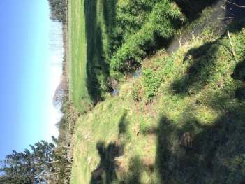
Assessment of Effects
    Potential operational effects of the Freight Hub have been considered in this assessment, including
    terrestrial vegetation loss, species habitat loss, stream loss, introduction of fish passage barriers,
    sediment discharge events, and stormwater discharges. These potential effects are considered to
    have Negligible to High Magnitudes of Effect on the Ecological Values present on site. Overall Levels
    of Effect range from Very Low to Low. With mitigation, correct culvert installation can result in a
    Positive Magnitude of Effect and an Overall Net Gain Ecological Effect.

    Recommendations

    •    No vegetation clearance conditions, or requirements, are recommended at this stage.

    •    Undertake salvage efforts for all herpetofauna on Site prior to commencing any earthworks,
         irrespective of their threat classification (due to their protection under the Wildlife Act 1953).

    •    Undertake salvage efforts for all fish and kōura (freshwater crayfish) within the affected
         reaches of stream prior to any works within the stream environment(s).

    •    Where possible, recreate open stream channel(s), preferably around the northern margin for
         the Freight Hub rather than through it.

    •    Ensure best practice sediment management is undertaken.

    •    Install appropriate and sufficient stormwater treatment devices to ensure any discharged
         water is of ecologically acceptable quality.

    •    Where possible, treated stormwater should be discharged into the remaining and/or replaced
         reached of the affected stream system 1 and northern tributary of stream system 2.

2   Boffa Miskell Ltd | Palmerston North Regional Freight Hub | Assessment of Ecological Values and Effects | 22 October 2020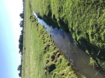
2.0 Introduction
Boffa Miskell Ltd has been engaged by Stantec New Zealand (on behalf of KiwiRail Holdings Ltd.) to
carry out an ecological assessment which forms part of the Assessment of Environmental Effects
prepared in support of the Notice of Requirement (NoR), for a proposed rail and freight hub (Freight
Hub) between Palmerston North and Bunnythorpe, immediately west of Railway Road (Designation
Extent).
2.1 The Project
The project will involve the construction and operation of a new Freight Hub, including associated
infrastructure (e.g. marshalling yards, container terminal, and stormwater treatment devices).
KiwiRail is seeking to enable works through a designation. A detailed design of the Freight Hub will
follow this process, along with the process of obtaining any relevant regional resource consents.
The Designation Extent includes 177.7 ha of primarily agricultural and lifestyle land and is situated
immediately west of Railway Rd which runs from Bunnythorpe to Palmerston North (Figure 1). This
Site is comprised primarily of pasture grasses (Charlton & Stewart, 1999), with some small areas of
exotic vegetation (e.g. pine shelterbelts).
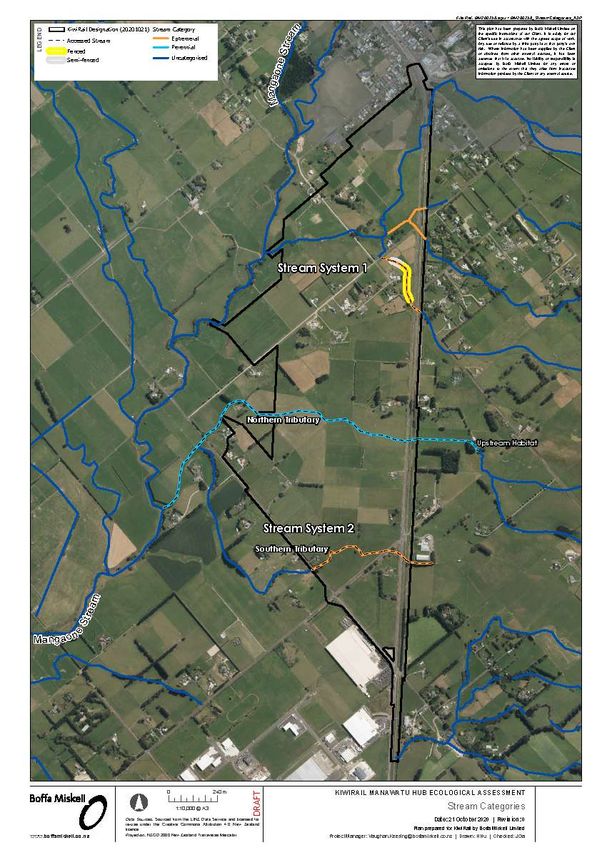
Two tributary systems of the Mangaone Stream catchment pass through the Designation Extent,
hereon considered Stream system 1 in the north and then Stream system 2 in the south (Figure 2).
Stream system 2 includes two tributaries which join downstream of the Designation Extent (they
are therefore assessed independently). Stream system 1 runs south/south-west across the site over
a length of approximately 2,352 m. The northern tributary of stream system 2 runs west from
Railway Rd for a length of 835 m through the site. The southern tributary of stream system 2 briefly
passes through the south-eastern corner of the Freight Hub location for approximately 590 m.
Boffa Miskell Ltd | Palmerston North Regional Freight Hub | Assessment of Ecological Values and Effects | 22 October 2020 3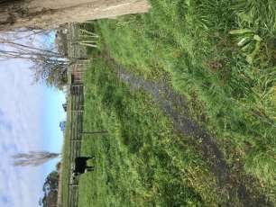
Figure 1: Location of the Freight Hub within the landscape. Included are sections of waterway identified as Sites of Significance
     in Schedule B of the One Plan and the OSNZ square used to compile a list of avifauna that may frequent the Freight Hub area.

4   Boffa Miskell Ltd | Palmerston North Regional Freight Hub | Assessment of Ecological Values and Effects | 22 October 2020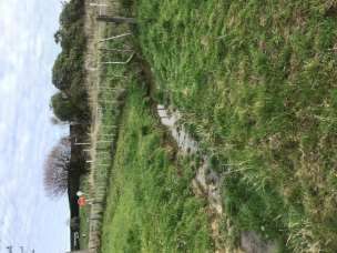
2.2       Scope of assessment
This report assesses the ecological values present and the level of potential ecological effects of the
proposed activities for which the NoR is sought. For the purposes of this assessment, we have
assessed the ecological values of the Designation Extent and the likely ecological effects based on a
conservative assessment of the proposed activities for which the NoR is sought.

This report outlines:

    •   The methods of assessment;

    •   The existing environment;

    •   The ecological values of the site;

    •   The potential ecological effects of the Freight Hub; and

    •   Recommendations to mitigate potential effects.

2.3       Definitions used in this report
The following definitions are applied to terms used throughout this report:

    •   Designation Extent - the proposed extent of land which KiwiRail is seeking to designate for
        the Freight Hub through the NoR.

    •   Freight Hub – KiwiRail's proposed rail and freight hub near Palmerston North.

    •   EIANZ – Environment Institute of Australia and New Zealand

    •   One Plan – The Consolidated Regional Policy Statement, Regional Plan and Regional
        Coastal Plan for the Manawatu-Wanganui Region (Horizons Regional Council)

    •   NPS-FM (2020) – the National Policy Statement of Freshwater Management 2020

    •   NES-FW (2020) – The Resource Management (National Environmental Standards for
        Freshwater) Regulations 2020

    •   NoR – The Notice of Requirement to which this assessment relates to.

3.0 Methods of Assessment

3.1       Assessing ecological values
The method used to undertake this assessment of effects is consistent with the Environment
Institute Of Australia And New Zealand (EIANZ) guidelines for undertaking ecological impact
assessments (Roper-Lindsay et al., 2018), whereby ecological values are assigned (refer to Table 1
for species and Table 2 for vegetation and habitat) and the magnitude of effects identified (Table 3)
in order to determine the overall level of effect of the proposal (Table 4).

          Boffa Miskell Ltd | Palmerston North Regional Freight Hub | Assessment of Ecological Values and Effects | 22 October 2020   5
Table 1: Criteria for assigning ecological value to species (Roper-Lindsay et al., 2018).
ECOLOGICAL VALUE SPECIES CLASSIFICATION
Nationally Threatened (Nationally Critical, Nationally Endangered, Nationally
Very High
Vulnerable) species found in the ZOI1 either permanently or seasonally.
Species listed as At Risk – Declining found in the ZOI either permanently or
High
seasonally.
Species listed as any other category of At Risk (Recovering, Relict, Naturally
Moderate Uncommon) found in the ZOI either permanently or seasonally; or Locally (ED)
uncommon or distinctive species.
Low Nationally and locally common indigenous species.
Negligible Exotic species, including pests, species having recreational value.
Table 2: Assigning overall value to areas (refer to Appendix 1 for the four (terrestrial) or five (freshwater) matters to be considered)
(Roper-Lindsay et al., 2018).
VALUE DESCRIPTION
Area rates High for three or all of the four assessment matters listed in Appendix 1.
Very High
Likely to be nationally important and recognised as such.
Area rates High for two of the assessment matters listed in Appendix 1, Moderate and Low for
the remainder, or Area rates High for one of the assessment maters, Moderate for the
High
remainder.
Likely to be regionally important and recognised as such.
Area rates High for one matter listed in Appendix 1, Moderate and Low for the remainder, or
Moderate Area rates Moderate for two or more assessment matters Low or Very Low for the remainder
Likely to be important at the level of the Ecological District.
Area rates Low or Very Low for majority of assessment matters and Moderate for one.
Low
Limited ecological value other than as local habitat for tolerant native species.
Negligible Area rates Very Low for three matters and Moderate, Low or Very Low for remainder.
1 Roper-Lindsay et al. (2018) define the Zone of Influence (ZOI) as “the areas/resources that may be affected by the
biophysical changes caused by the proposed project and associated activities.”
6 Boffa Miskell Ltd | Palmerston North Regional Freight Hub | Assessment of Ecological Values and Effects | 22 October 2020Table 3: Criteria for describing magnitude of effect (Roper-Lindsay et al., 2018).
MAGNITUDE DESCRIPTION
Total loss of, or very major alteration, to key elements/ features of the baseline conditions such
that the post development character/ composition/ attributes will be fundamentally changed
Very High
and may be lost from the site altogether; AND/OR
Loss of a very high proportion of the known population or range of the element / feature.
Major loss or major alteration to key elements/ features of the existing baseline conditions such
that the post-development character, composition and/or attributes will be fundamentally
High
changed; AND/OR
Loss of a high proportion of the known population or range of the element / feature.
Loss or alteration to one or more key elements/features of the existing baseline conditions, such
that post-development character, composition and/or attributes will be partially changed;
Moderate
AND/OR
Loss of a moderate proportion of the known population or range of the element / feature.
Minor shift away from baseline conditions. Change arising from the loss/alteration will be
discernible, but underlying character, composition and/or attributes of the existing baseline
Low
condition will be similar to pre-development circumstances/patterns; AND/OR
Having a minor effect on the known population or range of the element / feature.
Very slight change from existing baseline condition. Change barely distinguishable,
Negligible approximating to the “no change” situation; AND/OR
Having a negligible effect on the known population or range of the element / feature.
Table 4: Criteria for describing the level of effect (Roper-Lindsay et al., 2018).
ECOLOGICAL AND / OR CONSERVATION VALUE
LEVEL OF EFFECT
Very High High Moderate Low Negligible
Very High Very High Very High High Moderate Low
High Very High Very High Moderate Low Very Low
MAGNITUDE
Moderate High High Moderate Low Very Low
Low Moderate Low Low Very Low Very Low
Negligible Low Very Low Very Low Very Low Very Low
Positive Net gain Net gain Net gain Net gain Net gain
To assess the existing ecological significance and values of the Designation Extent:
• Information was gathered from relevant published and unpublished sources through a
desktop investigation.
• Field investigations were undertaken to provide further context in assessing onsite values.
3.2 Desktop investigation
The desktop investigation included a review of existing site inventories, national databases,
management plans, and publicly available literature. Specific details of the material used for the
desktop investigation are as follows:
Boffa Miskell Ltd | Palmerston North Regional Freight Hub | Assessment of Ecological Values and Effects | 22 October 2020 7i. Terrestrial vegetation – recent and historical aerials of the site were used (in
combination with a literature search) to determine the vegetation currently present
within the site, and the land use history.
ii. Herpetofauna – Records from the DOC administered BioWeb database were retrieved
to determine the species present within the wider area. Aerials were also used to
provide guidance on potential lizard habitats within the site, to be ground-truthed
during field investigations.
iii. Avifauna – data from the Ornithological Society of New Zealand (OSNZ) bird atlas (C. J.
R. Robertson et al., 2007) were used to determine the bird species recorded near the
location of the Freight Hub. The OSNZ bird atlas sections New Zealand into a series of
10 km by 10 km squares, of which the Designation Extent falls within the BO74 square
(see Figure 1 for extent of square). This square was used to compile a list of potential
bird species that may frequent the Designation Extent and surrounds.
iv. Freshwater environment (physical habitat, aquatic fauna) – data from the NIWA
freshwater fish database (NZFFD) and the NZ river environment classification (REC)
provided information on the characteristics and potential fauna of the Mangaone
Stream and its tributaries. Council data, from State of the Environment monitoring,
any publicly available relevant resource consents, or other monitoring data was sought
from Horizons Regional Council (but none was found). Current and historical aerials
provided context regarding flow and channel paths and riparian condition over time.
3.3 Field surveys
A site walkover was undertaken on 27 and 28 July 2020 to confirm the terrestrial vegetation
condition and to verify the streams and aquatic habitats (including wetlands) within, upstream, and
downstream, of the Designation Extent. Terrestrial vegetation was investigated and recorded
where aerials suggested some presence. The walkover allowed for the mapping and description of
waterways and wetlands (as defined by the Resource Management Act 1991 (RMA)) within the
Designation Extent. Not all properties in the Designation Extent were visited, as the intent was to
get a general sense of the environment, and at the time of the field surveys, not all could be
accessed and the full extent of the designation, including for stormwater treatment and other
mitigation features, was still being developed. However, we believe the areas surveyed provide a
good representation of the Designation Extent as a whole and we do not expect there to be any
unseen/unvisited ecological features that would have a material effect on this ecological
assessment. The following qualitative approaches were used to assist the describing and valuing of
ecological aspects:
• Opportunistic recording and identification of ecological features (such as vegetation);
• Visual searches for suitable avifauna and herpetofauna habitats as a proxy for potential
faunal habitation/use;
• Walking of watercourses (where accessible) and recording of typical morphological
conditions/features;
8 Boffa Miskell Ltd | Palmerston North Regional Freight Hub | Assessment of Ecological Values and Effects | 22 October 2020• Visual identification of potential aquatic fauna habitat (such as undercut banks, substrate
complexity).
For the purpose of this assessment no quantitative surveys were conducted. At the time of site
visits, qualitative surveys were considered appropriate for describing and assessing the ecological
value(s) of this highly modified landscape.
Terrestrial vegetation
The terrestrial vegetation and its condition were qualitatively described and recorded during the
site visits. In some cases, it could only be described from afar due to access arrangements. The
absence of notable and complex indigenous vegetation meant comprehensive and complete
vegetation lists were not considered necessary and so not developed.
Avifauna
No specific avifauna field surveys were conducted due to a combination of lack of indigenous
avifauna habitat for them and the highly modified nature of the farmland surveyed.
Herpetofauna
As with the avifauna, specific herpetofauna field surveys were not conducted based on the absence
of suitable habitat within the Designation Extent (e.g. lack of refugia, food sources, etc). Given the
potential for only Not Threatened2 skink species to be present (i.e. northern grass skink) survey
work would not add to the values assessment. Salvage requirements at the resource consent stage
would likely require trapping effort for all species in any case. The risk of not identifying a
conservation special species on site is considered very small because of the nature of the highly
modified and frequently disturbed environment.
Stream habitats and morphology
Habitat characteristics were noted and described including both instream (e.g. substrate, hydraulic
components) and along the banks (e.g. erosion, riparian vegetation, buffer width).
Additionally, each tributary reach and/or branch was classified as either perennial, intermittent, or
ephemeral, according to the following Auckland Unitary Plan definitions (Auckland Council 2016)3:
i. Ephemeral stream: Stream reaches with a bed above the water table at all times, with
water only flowing during and after rain events. This category is defined as those
stream reaches that do not meet the definition of permanent river or stream or
intermittent stream.
ii. Permanent river or stream (Perennial): The continually flowing reaches of any river or
stream.
Water quality
Water quality parameters were not measured as they are not relevant to this assessment at this
stage.
2
(Hitchmough et al., 2016)
Boffa Miskell Ltd | Palmerston North Regional Freight Hub | Assessment of Ecological Values and Effects | 22 October 2020 9Benthic substrates
The benthic substrates were noted and described, including visual estimation of the percentage
cover of each substrate size/class. No specific deposited fine sediment measures (as described in
Clapcott et al. (2011)) were made due to difficulties in distinguishing unnatural fine sediment
loading from the prevailing soft-bottom nature of the waterways.
Periphyton/didymo/aquatic macrophytes
While the presence and species of macrophyte was noted, no detailed periphyton or macrophyte
surveys were undertaken as a winter survey does not produce meaningful results related to warm
season habitat provision and issues (when macrophyte and periphyton can be problematic).
Due to the timing of the NoR process, warm-weather survey was not achievable, although it is
expected to be included as part of the regional resource consenting process.
Aquatic fauna
No macroinvertebrate community samples were collected at the time of the survey due to the
streams being regularly unfenced from stock (i.e. stock access to waterways was permitted) and
the prevailing soft-bottom nature (fine sediments) making it possible to estimate the
macroinvertebrate community composition without sampling.
No fish surveys were conducted due to the relatively uniform habitat opportunities and existing
predominantly unfenced nature of the watercourse. The fish fauna that are potentially present
relies on the NIWA Freshwater Fish Database and the surveyor's experience.
4.0 Description of Existing Environment
4.1 Site context
The Site falls within the Manawatu Plains Ecological District (31.01), in the Manawatu Ecological
Region (31) (McEwen, 1987). This district is characterised by low altitude, loess covered plains and
alluvial terraces. It has a range of soils including volcanic ash, loess, clay and peat soils. The
vegetation was originally comprised of semi-swamp forest (kahikatea and pukatea) on low-lying
land near rivers, totara forest in lower rainfall areas or stony soils, mixed podocarp on the plains
east of the Manawatu River, as well as areas of black beech and flax swamp.
The district is now highly modified, with the majority of indigenous vegetation cleared for farming.
It is currently dominated by pasture and other exotic vegetation (e.g. pine, orchards), though there
remain some small, isolated areas of flax swamp, totara forests, and black beech forests.
4.2 Terrestrial environment
The terrestrial environment has been considered in terms of:
• vegetation
• avifauna; and
10 Boffa Miskell Ltd | Palmerston North Regional Freight Hub | Assessment of Ecological Values and Effects | 22 October 2020• herpetofauna.
4.2.1 Terrestrial vegetation
There are no features within the Designation Extent recognised by Schedule F (Indigenous
Biological Diversity) of the One Plan which identifies rare, threatened, and at-risk habitats in the
Region.
During the site walkover, only stands/pockets of exotic vegetation (e.g. pines, eucalypts) and
recently planted native amenity vegetation were observed that differed from standard farming
pastures and vegetation (e.g. grasses, hedgerows). The vegetation communities are described
accordingly.
Native amenity plantings
The presence of notable native vegetation patches/communities is limited to sporadic and small
areas of recently planted native vegetation, typically surrounding dwellings. Typically, it appeared
these plantings were for landscaping rather than ecological benefit. Lemonwood, cabbage tree,
manuka were the dominant species used, with flax being the common shrub-layer species. Of the
observed native planting areas, they were approximately 10 or less years old (i.e. no mature
patches were observed).
Exotic plantations
Small patches of pine and eucalypt plantations (woodlots) were observed throughout the proposed
hub location. These monoculture areas typically did not have any native or exotic undergrowth;
however, occasional ferns were observed.
Agricultural vegetation communities
The most prominent vegetation throughout the Designation Extent was species and communities
commonly associated with agricultural practices. This included pasture grasses for grazing
purposes, hedgerows (most commonly barberry), and shelterbelts (typically cypress species).
4.2.2 Avifauna
The OSNZ Bird Atlas has records of 27 species of bird for the 10 km x 10 km grid within which the
Designation Extent falls. Of these, eight species are classified as Threatened or At-Risk4; these are
summarised below in Table 5.
4
(H. A. Robertson et al., 2017)
Boffa Miskell Ltd | Palmerston North Regional Freight Hub | Assessment of Ecological Values and Effects | 22 October 2020 11Table 5: At-Risk or Threatened species potentially present in or around the site, according to the OSNZ bird atlas.
Conservation Status
Common name Species name
(H. A. Robertson et al., 2017)
Threatened - Nationally Vulnerable
Pied Shag Phalacrocorax varius varius
Threatened - Nationally Vulnerable
Banded Dotterel ssp Charadrius bicinctus bicinctus
Larus novaehollandiae scopulinus At Risk - Declining
Red-billed Gull
Himantopus h. leucocephalus At Risk - Recovering
Australasian Pied Stilt
Phalacrocorax carbo
At Risk - Naturally Uncommon
Black Shag novaehollandiae
At Risk - Naturally Uncommon
Little Black Shag Phalacrocorax sulcirostris
Fulica atra australis At Risk - Naturally Uncommon
Australian Coot
Charadrius melanops At Risk - Naturally Uncommon
Black-fronted Dotterel
The Threatened and At Risk species are all associated with the larger rivers (Manawatu) or lake and
other larger waterbodies and their edges (i.e. dotterel, coot, pied stilt, red-billed gull, and shags).
Aerials of the Site do not show any suitable nesting or staging habitat for these species making it
unlikely these species frequent the Bunnythorpe farmlands (although some might alight here
occasionally).
The Not Threatened indigenous and Introduced and Naturalised exotic species5 present or likely to
be present (those common to highly modified agricultural landscapes in the Manawatu), include:
• Finches (gold, green, chaffinch)
• Red poll
• Magpie
• House sparrow
• Hedge sparrow/dunnock
• Paradise shelduck
• Australasian harrier
• Pukeko
• Spur-winged plover
• Welcome swallow
• Silvereye
5
(H. A. Robertson et al., 2017)
12 Boffa Miskell Ltd | Palmerston North Regional Freight Hub | Assessment of Ecological Values and Effects | 22 October 2020• Feral turkey
• Yellowhammer
• Song thrush
• Black bird
• Starling
• Skylark
• Rook
• Myna
The only natives likely to use pastural habitats (though not necessarily as primary habitat) include
silver eye, pukeko, harrier, plover, and kingfisher. Unusually, pipit (At Risk - Declining), which is
known to frequent open pasture habitats, has not been recorded at the Site.
4.2.3 Herpetofauna
To capture any lizards that may be present within the surrounding landscape, herpetofauna
records within a 30 km radius of the Designation Extent were retrieved from the DOC herpetofauna
database (BioWeb). Eight species of native lizard have been recorded within this area and are
described below in Table 6.
Table 6: Native lizards recorded within 30 km of the study area.
Common Name Scientific Name Conservation Habitat Preferences Functional group
Status6
Northern grass Oligosoma Not Dry open areas with low vegetation or Terrestrial skink
skink polychroma Threatened debris such as logs or stones for cover.
Glossy brown Oligosoma At Risk - Forest, scrub, grassland and Terrestrial skink
skink zelandicum Declining boulderfields.
Ornate skink Oligosoma At Risk - Forest and shrublands with damp leaf Terrestrial skink
ornatum Declining litter or rocks/logs
Raukawa gecko Woodworthia Not Forest, scrub, grassland, boulderfields Terrestrial/arbor
maculata Threatened and coastal areas. eal gecko
Pacific gecko Dactylocnemis At Risk - Forest, scrub, grassland, boulderfields Terrestrial/arbor
pacificus Relict and coastal areas. eal gecko
Forest gecko Mokopirirakau At Risk - Forest and scrub, especially kanuka / Arboreal gecko
granulatus Declining manuka, and creviced clay banks
6
(Hitchmough et al., 2016)
Boffa Miskell Ltd | Palmerston North Regional Freight Hub | Assessment of Ecological Values and Effects | 22 October 2020 13Common Name Scientific Name Conservation Habitat Preferences Functional group
Status6
Ngahere Mokopirirakau At Risk – Forest and scrub, especially kanuka / Arboreal gecko
gecko “Southern North Declining manuka, and creviced clay banks
Island”
Barking Naultinus At Risk – Forest and scrub, especially kanuka / Arboreal gecko
Gecko punctatus Declining manuka.
Five species of exotic/invasive herpetofauna were also recorded on the BioWeb database, including
three species of frog and two species of lizard.
During the site walkover on 27 and 28 July, no suitable habitat for geckoes or forest floor-dwelling
skinks was observed. It is considered unlikely any species other than the Not Threatened northern
grass skink reside within the Designation Extent.
4.3 Aquatic environment
The aquatic environment has been considered in terms of:
• Wetland environments; and
• Stream environments
4.3.1 Wetland environments
No wetland habitats were observed in areas that could be accessed during the site walkover. This
includes wetlands as defined in Schedule F of the One Plan, or as defined in the RMA and the
recently operative National Policy Statement for Freshwater Management 2020 (NPS-FM (2020)).
Furthermore, no obvious wetland habitats are visible from publicly accessible aerials of the site
within the areas that could not be accessed during the site walkover.
4.3.2 Stream environments
The Mangaone Stream is recognised in the One Plan’s schedule B (Surface water management
values) (denoted on Figure 1). It is divided into two sections/reaches, including the Upper
Mangaone (from Milson’s Line upwards) and the lower Mangaone (from the Manawatu to Milsons
line). Schedule B does not highlight them as holding ecological values (i.e. no sites of significance
for aquatic or riparian, no inanga spawning, and significance for trout). However, it retains capacity
to assimilate pollution, and its life supporting capacity is that of a lowland mixed.
The Mangaone Stream originates north of Bunnythorpe and discharges into the Manawatu River
main stem just south of the Palmerston North landfill. Much of its lower reaches are in urban
landscapes and most of its upper reaches are in hill country agriculture. The rest is in lowland
farmland.
14 Boffa Miskell Ltd | Palmerston North Regional Freight Hub | Assessment of Ecological Values and Effects | 22 October 2020There are two unnamed stream systems that flow through the Designation Extent (Figure 2). The stream systems typically flow in an east-west direction before draining into the Mangaone Stream. The stream systems are described below. Stream system 1 Stream system 1 includes three branches of the system that merge into a single central channel near Te Ngaio Road (Figure 2). In total, there is approximately 2,352 linear m of stream channel in Stream system 1 that falls within the Designation Extent. In locations where the branches could be accessed, they all resembled ephemeral flow paths with no active beds and no defined channels and/or banks. Best access was gained along the branch that runs near parallel with Te Ngaio Road. The stream was a shallow “u”-shaped channel with terrestrial/pasture grasses common throughout the channel. There was no discernible flow at the time of survey on 27 and 28 July 2020. Historical stock access was evident with no defined bank and it was pugging throughout. However, some sections have a newly installed (
Stream system 2

     Northern tributary
     The northern tributary (Figure 2) of the Mangaone Stream catchment comprises a single channel
     which is approximately 835 m long that flows through the central portion of the Designation
     Extent. It is soft-bottomed throughout and typically comprises slow run habitat. Some incision was
     evident in the lower reaches (>0.5 m in places) which was also fenced to exclude stock. The middle
     and upper portions of the stream was unfenced meaning shallow, pugged banks dominated.
     Macrophytes (predominantly water pepper (Persicaria hydropiper)) were mostly found in the lower
     reaches which also had some riparian vegetation. That vegetation was predominantly flax
     (Phormium tenax) and has been planted throughout the lower reaches. However, where present,
     the riparian vegetation lacked the complexity needed to provide material benefits to the stream
     (other than serve as a barrier to stock). The stream typically varied between 0.5-1 m wide in the
     lower reaches before becoming more homogenous in the middle and upper reaches (typically 0.5
     m wide). Depth varied between 30 cm and 60 cm throughout the surveyed and accessible
     reach(es).

      Image 3: Downstream extent of the northern tributary within        Image 4: Typical upper reach of the northern tributary of
      stream system 2 which may be impacted. Note it is largely          stream system 2. Note the absence of riparian vegetation and
      unfenced and unvegetated, though some small, isolated              fencing.
      patches of vegetation do exist.

     Northern tributary - upstream habitat
     Upstream of the Designation Extent, where visited (Figure 2), the northern tributary of stream
     system 2 resembles an incised (> 1m high banks) and straightened channel which was fenced
     (fence typically 1 m from bank edge) to exclude stock. Riparian trees were limited to planted pine
     groves; however, rank vegetation (primarily rank pasture grasses with scattered juncus and sedge)
     along the banks did provide some fish cover, and slumping banks added further cover and

16   Boffa Miskell Ltd | Palmerston North Regional Freight Hub | Assessment of Ecological Values and Effects | 22 October 2020
complexity. Where vantage was gained, water depth appeared to vary between 30 cm and 50 cm,
and the wetted width ranged between 0.5-1 m. At the time of survey on 27 and 28 July 2020, there
was no discernible flow.
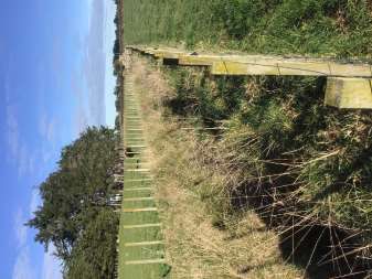
Image 5: Northern tributary of stream system 2, upstream of Image 6: Open channel section of the Northern tributary,
the Designation Extent. Note the artificially incised and upstream of the Designation Extent, with negligible flows.
straightened nature of the channel. However, the incision
provides some shading and the stream is largely fenced
throughout.
Southern tributary
The southern tributary of stream system 2 (Figure 2) is a shallow, ephemeral flow path that was dry
at the time of survey on 27 and 28 July 2020. Approximately 590 linear meters of this stream
channel is within the Designation Extent. This watercourse better resembled a roadside drainage
system that had pasture grasses planted throughout. The absence of any aquatic habitat or
features meant no physical habitat assessment was completed for the potentially affected reach.
Boffa Miskell Ltd | Palmerston North Regional Freight Hub | Assessment of Ecological Values and Effects | 22 October 2020 17Figure 2: Map showing the location and the nature of flows within each stream system. The dotted lines denote stretches of
stream which were accessible at the time of visit.
18 Boffa Miskell Ltd | Palmerston North Regional Freight Hub | Assessment of Ecological Values and Effects | 22 October 20204.4 Aquatic fauna
The NIWA administered New Zealand Freshwater Fish Database (NZFFD; accessed 27/08/2020)
shows 10 species of freshwater fish have been recorded in the Mangaone Stream catchment,
including six indigenous species and four introduced species (Table 7). Additionally, the NZFFD
allows for records of freshwater crayfish, mussel, and shrimp observations, of which all have been
recorded in the catchment.
The ephemeral nature of Stream 1 and the southern tributary of Stream system 2 make it unlikely
any of the recorded species in the Mangaone Stream catchment reside in these streams. However,
there is the potential that eels may utilize Stream 1 during wet periods for foraging purposes.
The lower third of Stream 2 contained suitable fish cover. However, the habitat quality meant it is
likely only eels and possibly common bully reside within it. Conversely, the upper two thirds did not
provide much, if any, fish cover due to the absence of fencing, lack of stream shading, pugged and
homogenous banks, and absence of instream complexity. This section of the stream is likely only
used as a passageway to better habitat upstream (although that too is in a similar land use), whilst
providing no respite for fish as they migrate. As such, this section is unlikely to contain a stable fish
community. Furthermore, the prevalence of stock access is likely to preclude the establishment of a
freshwater mussel community.
Fish habitat and cover is provided upstream of the Freight Hub in the northern tributary of Stream
2. The nature and condition of Stream 2 at this location makes it suitable for eels, common bully,
and potentially inanga (assuming there are no downstream barriers). Though banded kokopu have
not been recorded in the Mangaone Stream, the stretch of the northern tributary of Stream system
2, upstream of the proposed hub also provides suitable habitat for them should they be within the
catchment.
Table 7: New Zealand Freshwater Fish Database records for the Mangaone Stream catchment (database accessed 27/08/2020).
Fish conservation status from (Dunn et al., 2018). Invertebrate conservation status from (Grainger et al., 2018).
Common name Scientific name Conservation status Number of Potentially
records present
Shortfin eel Anguilla australis Not Threatened 8 √
Longfin eel Anguilla dieffenbachii At Risk - Declining 3 √
Inanga Galaxias maculatus At risk - Declining 2 √
Upland bully Gobiomorphus breviceps Not Threatened 1 √
Common bully Gobiomorphus catidianus Not Threatened 6
Common smelt Retropinna retropinna Not Threatened 1
Freshwater mussel Echyridella menziesii At Risk - Declining 2
Koura (freshwater Paranephrops spp. Not Threatened7 4 √
crayfish)
7
Based on geographical context, it is highly likely any crayfish within the catchment are the Not Threatened
Paranephrops planifrons, rather than the At Risk – Declining Paranephrops zealandicus.
Boffa Miskell Ltd | Palmerston North Regional Freight Hub | Assessment of Ecological Values and Effects | 22 October 2020 19Common name Scientific name Conservation status Number of Potentially
records present
Freshwater shrimp Paratya curvirostris Not Threatened 3
Gambusia Gambusia affinis Introduced and naturalised 1
Goldfish Carassius auratus Introduced and naturalised 4
Perch Perca fluviatilis Introduced and naturalised 1
Brown trout Salmo trutta Introduced and naturalised 3
4.5 Macroinvertebrate community
The dominance of fine sediments, sporadic macrophytes, prevalence of stock access, and limited
flows with long, slow runs strongly supports the presence of a tolerant (i.e. non sensitive)
macroinvertebrate community. Therefore, community is expected to be mainly comprised of snails,
true fly larvae, copepods, amphipods, worms and mites, and hemiptera. These types of slow, soft
bottomed, agricultural-based streams typically have an MCI around 70-90 and a QMCI 3-4. These
indices values are indicative of poor-fair water quality and/or polluted systems (Stark & Maxted,
2007). Potamopyrgus and Physa snails are usually numerically dominant along with Chironomus
species, black fly (Austrosimulium), Tanypodinae, Culex, water beetles (Rhantus, Dytisicade)
damselfly’s (Xanthocnemis), and true bugs (Microvelis, Sigara). There will be very limited sensitive
EPT (Ephemeroptera, Trichoptera, Plecoptera) species, with likely no stonefly and one or two
caddisfly (most likely Aoteapsyche and Pycnocentrodes). It will be a pollution-tolerant, soft
bottomed, depauperate, drying-resilient community of “low” representative value.
5.0 Ecological values
5.1 Terrestrial environment
The ecological value of each terrestrial unit or feature is assessed and determined according to the
EIANZ 2018 (Roper-Lindsay et al., 2018) guidelines (described in Section 3.1 above) and presented
individually below.
20 Boffa Miskell Ltd | Palmerston North Regional Freight Hub | Assessment of Ecological Values and Effects | 22 October 20205.1.1 Terrestrial vegetation communities
Vegetation Description Attribute values Overall
community value
Native Representativeness – The planted Representativeness – Negligible
amenity vegetation is not representative of Negligible
plantings historic vegetation communities.
Rarity and distinctiveness –
Rarity and distinctiveness – There are Negligible
no rare or distinct species or
Diversity and pattern – Low
communities. While the LENZ (Landcare
Research Ltd, 2012) layer shows that Ecological context –
there is less than 10% indigenous Negligible
habitat remaining on this land class and
indigenous vegetarian on this land
system can be considered “rare”, the
planting is not representative of a
natural early succession and cannot, as
yet, be considered in this way.
Diversity and pattern – These
communities had low diversity and
limited pattern.
Ecological context – The amenity
plantings are small and sporadic across
the landscape and typically associated
with a dwelling. Because these
communities are induced, they are
expected to be tolerant and resilient but
do not provide a material ecological
benefit to the landscape.
Exotic Representativeness – These are not Representativeness – Negligible
plantations representative. Negligible
Rarity and distinctiveness – They are Rarity and distinctiveness –
not rare or distinct communities. Negligible
Diversity and pattern – These are Diversity and pattern –
monoculture communities. Negligible
Ecological context – These areas are Ecological context –
often the only patches of dense, tall, Moderate
mature vegetation within the landscape
and may provide shelter and stepping-
stones for some fauna.
Boffa Miskell Ltd | Palmerston North Regional Freight Hub | Assessment of Ecological Values and Effects | 22 October 2020 21Vegetation Description Attribute values Overall
community value
Agricultural Representativeness – These are not Representativeness – Negligible
vegetation representative. Negligible
Rarity and distinctiveness – They are Rarity and distinctiveness –
not rare or distinct communities. Negligible
Diversity and pattern – These Diversity and pattern – Low
communities had low diversity and
Ecological context –
limited pattern beyond what is expected
Negligible
for agricultural pasture mixes and little
ecological value in the ‘pattern’ that is
present.
Ecological context – These communities
are designed to support
agricultural/farming practices;
therefore, they do not add to the wider
ecological context across the landscape.
5.1.2 Avifauna
No specific conservation-valued species appear in records or were observed during the site visit
and it is unlikely that there are any values associated with indigenous avifauna on site. Therefore,
overall, the avifauna community and all species within it are considered to have negligible
ecological value.
5.1.3 Herpetofauna
It is highly unlikely that any Threatened or At Risk lizard species are present within the Designation
Extent. However, there may be some (but in very low numbers if so) Not Threatened species.
Therefore, overall, the herpetofauna community and all species within it are considered to have
negligible ecological value.
5.2 Aquatic environment
The following sections assess and determine the ecological values of each surveyed stream system
using the criteria outlined in the EIANZ guidelines (Roper-Lindsay et al., 2018) (as outlined at
Section 3.1 above). The values assessments are provided in table format to align with the criteria in
the EIANZ guidelines and allow for corresponding dialogue.
22 Boffa Miskell Ltd | Palmerston North Regional Freight Hub | Assessment of Ecological Values and Effects | 22 October 2020Stream system 1
Criteria Assessment Value
Representativen This system, where observed, was indicative of a highly modified, ephemeral Negligible
ess flow path.
Rarity and There were no rare or distinct features of this stream and it is unlikely to support Low
distinctiveness threatened or at risk fish species.
Diversity and When flowing, the stream system is likely dominated by run habitats with no Low
pattern instream or bankside diversity/complexity. There are limited habitat
opportunities for macroinvertebrates and less so for fish due to it being
ephemeral.
Ecological Historic land clearance surrounding the reach to facilitate ongoing farming Low
context practices. Stock can access the stream in large parts and any fencing is resent (Criteria Assessment Value
Ecological Nativeness – expected depauperate macroinvertebrate community, which is Low
integrity indicative of degraded and soft-bottom conditions, no resident stable fish
populations expected (though some eels and common bully may reside in the
lower portion) - Low
Pristineness – heavily farmed and modified – Very low
Diversity – lack of diversity – Low
Resilience – extensive stock access and land clearance, with corresponding
effects on the stream, through flows are permanent – Low
OVERALL ECOLOGICAL VALUE Low
Northern tributary – upstream of Designation Extent
Criteria Assessment Value
Representative This system, where observed, was indicative of a highly modified, stream system Low
ness which was artificially incised and straightened.
Rarity and There were no rare or distinct features of this stream; however, it may support Low
distinctiveness threatened or at risk fish species.
Diversity and Typically, the stream is a slow-flowing run habitat with some bank slumping and Low
pattern overhanging vegetation providing complexity and fish cover. There is some
opportunity for fish habitation (more so than the aquatic environments within
the proposed hub location) but limited habitat opportunities for sensitive
macroinvertebrates.
Ecological Historic land clearance surrounding the reach to facilitate ongoing farming Moderate
context practices and artificial incising and straightening. No stock access within observed
locations. Riparian vegetation limited to rank grasses and shrubs which main
benefit would be shade and cover provision. However, this reach provides the
only permanent habitat for fish.
Ecological Nativeness – expected depauperate macroinvertebrate community, but likely Low
integrity resident stable fish populations – Low
Pristineness – heavily farmed and modified – Very low
Diversity – lack of diversity – Low
Resilience – extensive land clearance, with corresponding effects on the stream,
though stock are excluded – Moderate
OVERALL ECOLOGICAL VALUE Low
Southern tributary
As stream 3 was a dry, ephemeral flow path at the time of survey it does not warrant a full
assessment of aquatic ecological values. The absence of aquatic habitat means its only aquatic
value is as a contributing hydrological flow path to downstream aquatic environments. As such, it
has Negligible aquatic ecological value.
Aquatic fauna
The aquatic habitats present hold little capacity for indigenous flora and fauna and are not
representative of naturally occurring indigenous systems; however, they are likely to contain eel
and koura (longfin eel is technically an At Risk- Declining species). The values and conditions of the
24 Boffa Miskell Ltd | Palmerston North Regional Freight Hub | Assessment of Ecological Values and Effects | 22 October 2020existing aquatic systems do not suggest that there is a strong requirement to protect or retain any,
or all, of the tributaries present.
5.3 National and Regional Policy Documents
National and regional policy documents should be considered when assessing the ecological effects
of a proposal as these documents provide the criteria and definitions that, in part, determine what
effects may be appropriate, or otherwise, for any given region. These are considered and
commented on below.
National Policy Statement for Freshwater Management 2020 (NPS-FM (2020))
The NPS-FM (2020) places new emphasis on aquatic ecosystems and on the importance of
freshwater. Of particular relevance, Policy 7 directs that the loss of extent of river and values is
avoided to the extent practicable, and Policy 9 directs that the habitat of indigenous freshwater
species are protected. The NPS-FM (2020) will be particularly relevant to consider as part of the
regional resource consenting process.
National Environmental Standards for Freshwater 2020 (NES-FW (2020))
The NES-FW (2020) describes (among other things) what is expected when dealing with the
potential fish passage effects/impediments from the placement of certain structures in, on, over,
or under the bed of waterways and connected areas. It includes conditions for the placement of
certain structures which, when followed, become permitted activities. If these conditions are met,
then there are not expected to be any fish passage issues once the Freight Hub is operational.
Regional Policy Statement – The One Plan
The One Plan (Chapter 5, Policy 5-23) requires that if natural states8 and sites of significance
(including cultural or aquatic) are present / found then an activity should avoid adverse effects to
those values or features. The aquatic environment within the Designation Extent is not considered
to be in a natural state or a site of significance.
5.4 Summary of ecological values on site
• Terrestrial environment
o Vegetation – Negligible
o Avifauna habitat – Negligible
o Avifauna species – Negligible
o Herpetofauna habitat – Negligible
o Herpetofauna species - Negligible
8
Natural state is defined in the One Plan as being All sections of rivers and their beds that have sources in, and flow
within, the Public Conservation Land (land held under the Conservation Act 1987 or administered by the Department of
Conservation), with the exception of those where damming or diversion have significantly affected the natural state of
the water.
Boffa Miskell Ltd | Palmerston North Regional Freight Hub | Assessment of Ecological Values and Effects | 22 October 2020 25• Aquatic environment
o Wetlands – None present
o Aquatic habitat
▪ Stream system 1 – Low
▪ Stream system 2 (Northern tributary) – Low
▪ Stream system 2 (Southern tributary - Negligible
o Aquatic fauna
▪ Longfin eel (small possibility and in low numbers) – High (due to At Risk –
Declining conservation status)
▪ All other potential fauna -– Negligible (due to Not Threatened
conservation status)
6.0 Assessment of potential ecological effects
This section provides an assessment of the ecological effects of the NoR to inform an overall
assessment of the Freight Hub's potential effects. KiwiRail is currently seeking an NoR to designate
land for the Freight Hub. As such, detailed design of the Freight Hub has not yet been undertaken
and required regional resource consents will be sought at a later stage.
The type (and magnitude) of effects may change with refinements and further detail guiding the
final design of the Freight Hub and proposed construction methods. For the purposes of this
assessment, we have assessed the likely ecological effects based on a conservative assessment of
the Freight Hub from the concept design for the NoR.
Activities and ecological effects associated with the operation of the proposed Freight Hub, within
or adjacent to the Site, are likely to include:
• Vegetation clearance/loss;
• Loss of avifauna and herpetofauna habitat;
• Stream loss;
• Introduction of barriers to fish passage;
• Earthworks sediment related discharges to water; and
• Discharge of stormwater (operational).
Specific construction effects have not been included as part of this assessment (e.g. effects from
the construction of a haul road(s), laydown areas, and other associated infrastructure or specific
sites), other than to mention that there are likely to be earthworks and sediment related
discharges to water. These effects will be considered at the regional resource consenting stage.
26 Boffa Miskell Ltd | Palmerston North Regional Freight Hub | Assessment of Ecological Values and Effects | 22 October 2020The following subsections first present the relevant overall ecological effect by way of highlighting
i. the ecological value (as summarised in Section 5.0), ii. the expected magnitude of effect (i.e. the
scale), and iii. the expected overall level of ecological effect. A justification for the corresponding
assessment is then provided.
6.1 Vegetation clearance & Loss of avifauna and
herpetofauna habitat
i. The terrestrial vegetation and fauna all have negligible ecological value.
ii. The effects on these features are expected to have a low magnitude of effect.
iii. Therefore, the proposed Freight Hub is expected to have an overall very low level of
ecological effect on these features.
Given the largely exotic nature of the vegetation, the absence of indigenous habitat or particularly
functional riparian vegetation, and, where there are some areas of indigenous vegetation, the
simple species richness and young age of that indigenous planting, (notwithstanding the general
absence of indigenous species), the overall values are, as a whole, Negligible. The magnitude of the
proposed clearance, even if the entire site platform was cleared, would be at most Low. This is
because any changes that are expected result in a no more than minor shift from the existing
baseline within the wider landscape. The change will be discernible at the local level but will not
change the underlying character, nature or the resource base of the local fauna and will not affect
local populations of lizards, birds, insects.
A Negligible value and a low magnitude of effect results in a Very Low level of ecological effect on
the terrestrial vegetation and fauna which typically does not require any form of mitigation
response.
6.2 Stream loss
We assess the magnitude of stream loss in relation to the linear length of mapped stream within
each tributary catchment they are associated with, and then as part of the wider Mangaone Stream
catchment. The following summarises these losses and the magnitude of the loss:
Stream system 1
i. Stream system 1 has low ecological value.
ii. The effect of stream loss on the stream system 1 catchment is considered to be a low
magnitude of effect.
iii. Therefore, the proposed Freight Hub is expected to have an overall very low level of
ecological effect on stream system 1.
Approximately 2,352 linear meters of ephemeral stream is expected to be lost within stream
system 1. Using GIS, the stream system 1 catchment contains approximately 20,180 linear meters
of stream (much of which is expected to be ephemeral). This equates to a linear loss of
approximately 12% of stream length. This is considered a Low Magnitude of Effect (very slight
change from the existing baseline condition).
Boffa Miskell Ltd | Palmerston North Regional Freight Hub | Assessment of Ecological Values and Effects | 22 October 2020 27You can also read