Parson's Tunnel to Teignmouth Resilience Project Overview for Public Consultation
←
→
Page content transcription
If your browser does not render page correctly, please read the page content below
Transport and Works Act 1992

   The Transport and Works (Applications and Objections
        Procedure) (England and Wales) Rules 2006

                     The Network Rail (Parson’s Tunnel
                      to Teignmouth Resilience) Order

Parson’s Tunnel to Teignmouth
 Resilience Project Overview
    for Public Consultation

Document Reference
Author                  Network Rail
Date                    08 January 2020
Revision Number         0.5
                                              th
                                           ou
                                          m
                                      gn
                                       i
                                    Te

                                                              h
                                                             lis
                                                         aw
                                                         D
The Network Rail (Parson’s Tunnel to Teignmouth Resilience) Order
Project Overview for Public Consultation

Contents
1. History/Background                                                  5
     1.1    Introduction                                               5
     1.2    Background and context                                     5
     1.3    Chronology of detailed studies undertaken                  8
     1.4    Options considered in 2018                                10

     Proposed Development                                             14
     1.5    Introduction                                              14
     1.6    New Coastal Defence                                       14
     1.7    Land Reclamation                                          17
     1.8    Railway Realignment                                       18
     1.9    Cliff Stability (buttressing, dowels, rockfall shelter)   18
     1.10 Smugglers Lane/Bridge Redevelopment                         21
     1.11 Realigned South West Coast Path and new landward footpath   22
     1.12 Sprey Point (inc. viewing platform and footbridge)          23
     1.13 Other Ecological Mitigation Proposals                       24
     3.10 Design iterations following public feedback                 25

2. Outline Construction Methodology                                   25
     2.1    Introduction                                              25
     2.2    Mobilisation                                              25
     2.3    Coastal Defence construction                              26
     2.4    Rail Systems                                              29
     2.5    Cliff Stability Works                                     29
     2.6    Amenity Works                                             30

                                                    2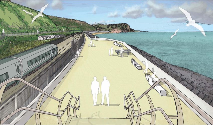
The Network Rail (Parson’s Tunnel to Teignmouth Resilience) Order
Project Overview for Public Consultation

3. Environmental Impact Assessment (EIA)                             31
     3.1    Introduction                                             31
     3.2    EIA Process                                              31
     3.3    EIA Scoping Report and Scoping Opinion                   31
     3.4    EIA Consultation                                         34
     3.5    Environmental Statement                                  34
     3.6    Additional Documents                                     35

4. Public consultation                                               36
     4.1    Introduction                                             36
     4.2    Feedback from first round of public consultation         36
     4.3    Revisions to scheme following consultation in 2019       41
     4.4    Responses to other key themes from public consultation   43

5. Statutory Consultation                                            45
     5.1    Introduction                                             45
     5.2    Statutory and Non Statutory Consultees                   45

6. Transport And Works Act Order                                     47
     6.1    What is a Transport and Works Act Order (TWAO)?          47
     6.2    What can a TWAO authorise?                               47
     6.3    Current TWAO Programme                                   47
     6.4    Further Reading                                          49

7. Consultation Contact Points                                       50
     7.1    About this consultation                                  50
     7.2    Responding online                                        50
     7.3    Other ways to respond                                    50
     7.4    Consultation principles                                  51

                                                    3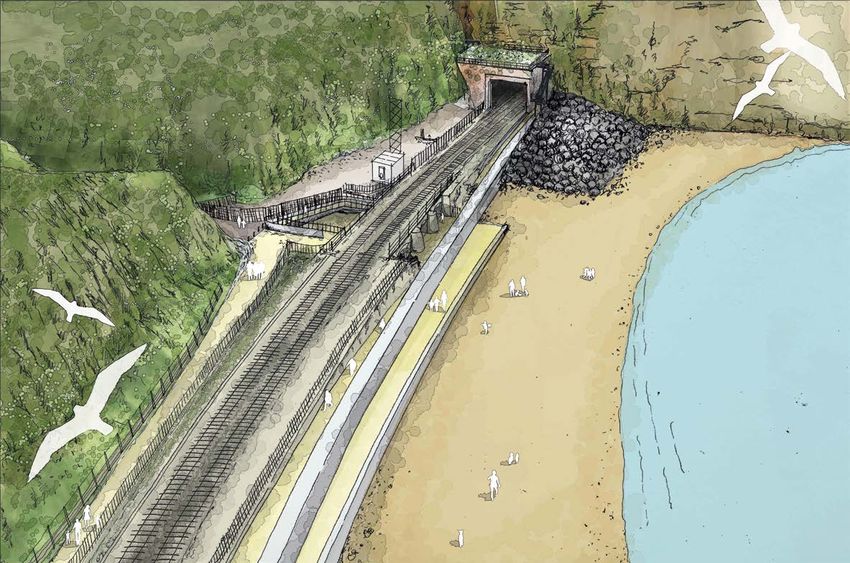
The Network Rail (Parson’s Tunnel to Teignmouth Resilience) Order
Project Overview for Public Consultation

Figures
Figure 1.1 – Holcombe Beach and the existing Seawall looking towards Parson’s Head   14
Figure 1.2 – Teignmouth Beach and the proposed Seawall looking towards Sprey Point   15
Figure 1.3 – Existing rock revetment adjacent to Parson’s Tunnel                     16
Figure 1.4 – Revetment Option Typical Section                                        17
Figure 1.5 – Location of Cliff Behavioural Units                                     19
Figure 1.6 – Buttresses shown behind railway line                                    19
Figure 1.7 – Parson’s Tunnel south portal rockfall shelter                           20
Figure 1.8 – Smugglers Bridge                                                        21
Figure 1.9 – Seawall promenade (between railway and beach)                           22
Figure 1.10 – Landward path on buttress. Teignmouth sign shown                       22
Figure 1.11 – Sprey Point                                                            23
Figure 2.1 – Backhoe dredger and support barge                                       26
Figure 2.2 – Trailing Suction Hopper Dredger                                         27

                                                    4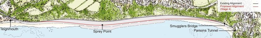
The Network Rail (Parson’s Tunnel to Teignmouth Resilience) Order
Project Overview for Public Consultation

1. History/Background
1.1    Introduction

1.1.1	This consultation document sets out Network Rail’s proposals for improving resilience
       of the railway between Parson’s Tunnel and Teignmouth in South Devon. Network Rail
       is running this consultation to help identify the views of residents, passengers, tourists,
       businesses and communities on the proposed works.

1.1.2	This document aims to provide you with a comprehensive breakdown of the
       proposed works; please read this all the way through and respond either online or
       via email. Full details of how to respond to this consultation are shown in Section 9.
       We must receive your response by 01 March 2020.

1.2    Background and context

The need for increased resilience

1.2.1	The railway is a vital transport artery, connecting communities, businesses and visitors
       in 50 towns and cities in the South West with the rest of the UK.

1.2.2	In 2014, there was major landslip near Holcombe, which dislodged thousands of
       tonnes of cliff material on to the track. At nearby Dawlish, the heavy storms caused the
       collapse of the Seawall leaving the railway hanging in mid-air.

1.2.3	For six weeks, all rail connectivity in and out of South Devon and Cornwall was severed.
       Urgent works were required to get trains running beyond Exeter, highlighting the
       vulnerability of the route. While the damage cost tens of millions of pounds to repair,
       the cost to the local and regional economy was far higher.

1.2.4	The West of Exeter study recommended that the existing route be made more resilient
       rather than building new/reopening old inland routes.

1.2.5	The South West Rail Resilience Programme was established to identify and implement
       the best options to maintain a resilient rail service to the South West peninsula.

1.2.6 Key to these plans is the Parson’s Tunnel to Teignmouth Resilience Project.

                                                    5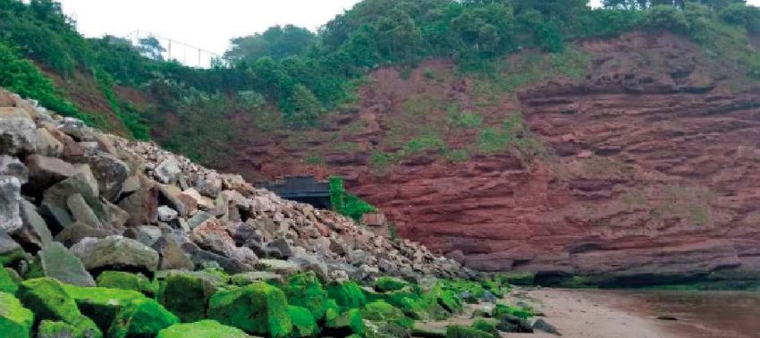
The Network Rail (Parson’s Tunnel to Teignmouth Resilience) Order
Project Overview for Public Consultation

How do you know the cliffs pose a risk to the railway?

1.2.7	Since the Western Route was first opened, there has been a long history of breaches
       in the coastal defences and many occurrences of cliff falls causing adverse impacts on
       the rail track and services. Throughout its operation, in order to keep the line in service
       and the public safe, significant effort and investment has been expended on remedial
       work and engineering improvements.

1.2.8	The locations of the identified historical cliff stability events are indicated above;
       further detail on these events including year of occurrence and descriptions of the
       events are available in Appendix B, Table B-1, in the Exeter to Newton Abbot Phase 1
       Baseline report at https://cdn.networkrail.co.uk/wp-content/uploads/2019/08/Exeter-
       Newton-Abbot-Resilience-Strategy-Phase-1-Appendices-CH2M-2016.pdf

                                                    6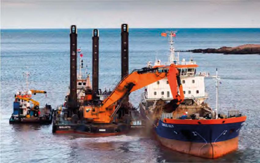
The Network Rail (Parson’s Tunnel to Teignmouth Resilience) Order
Project Overview for Public Consultation

Figure 1 – 1852. Source: http://www.                                          Figure 3 – 1930. Source: The Times, 31 July 2009
devonheritage.org/Places/Teignmouth/
TeignmouthLandslipsPart1page3.htm

                                                                              Figure 4 – 2000.

Figure 2 – 1855. Source: https://commons.wikimedia.
org/wiki/File:Accident_to_the_South_Devon_
Railway_at_Dawlish,_1855.jpg

Where available, online sources for these images are cited. Please also       Figure 5 – 2012. Further details at https://www.bbc.
refer to Exeter – Newton Abbot: A Railway History by Peter Kay.               co.uk/news/uk-england-devon-20565438

1.2.9	Historic evidence/reports (examples above) and scientific modelling based on
       forecasts have been used to predict the location and severity of future landslips.
       As recently as 2012, 14 landslips occurred on the Dawlish to Teignmouth line whilst
       24 landslips took place along the same stretch over 18 months between 2003
       and 2004. These events were widely reported by the national media.

                                                                          7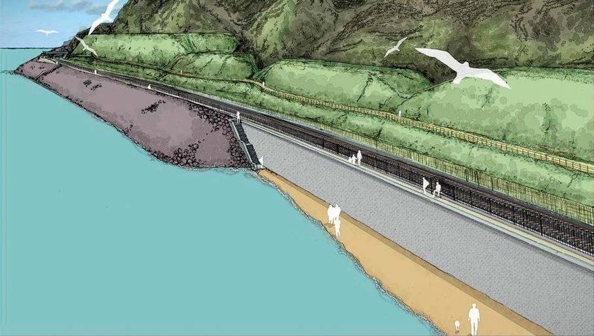
The Network Rail (Parson’s Tunnel to Teignmouth Resilience) Order
Project Overview for Public Consultation

1.2.10	In terms of forecasting future landslips, the change in frequency of cliff-related
        disruption events under the ‘do-minimum’ scenario from 2015 to 2115 are shown in
        the 2016 Resilience Strategy Report, (Phase 3, Page 5, table 2-2, Geotech line https://
        cdn.networkrail.co.uk/wp-content/uploads/2019/04/Exeter-Newton-Abbot-Phase-
        3-Option-Selection-Report.pdf). These demonstrate that a significant increase in all
        types of disruption event is forecast by 2065 with chances of disrupted service on the
        line drastically increased by 2115.

1.3      Chronology of detailed studies undertaken

      2014: As a result of the disruption in 2014, Network Rail was asked by Government to
1.3.1
      report on options to maintain a resilient rail service to the South West peninsula for
      100 years.

	We worked with stakeholders across local government, businesses, the Environment
  Agency and Train Operating Companies (TOCs) to produce the West of Exeter Route
  Resilience Study. The report used specific criteria to identify and assess valid options.
  These criteria included resilience against environmental threats, value for money and
  feasibility to build and operate:

         •O
           ption 1 – Continuing the current maintenance regime on the existing route.

         •O
           ption 2 – Further strengthening the existing railway (from Exeter to Newton
          Abbot). An early estimated cost of between £398 million and £659 million would
          be spread over four Control Periods with a series of trigger and hold points to reflect
          funding availability, spend profile and achieved level of resilience. – This option was
          taken forward in further studies carried out by Consultants CH2M in 2016.

         •O
           ption 3 (Alternative Route A) – The former London & South Western Railway route
          from Exeter to Plymouth via Okehampton would be reconstructed.

         •O
           ption 4 (Alternative Route B) – Constructing a modern double track railway on
          the alignment of the former Teign Valley branch line from Exeter to Newton Abbot.
          There is doubt as to whether a resilient railway is practical on this route.

         •O
           ption 5 (Alternative Routes C1 to C5) – Five alternative direct routes would provide
          a new line between Exeter and Newton Abbot.

	The West of Exeter Route Resilience Study concluded that, even if certain revenue
  and unpriced benefits are doubled and the capital outlays halved in combination, the
  financial business case and transport economic case for all of the additional route
  options appear to remain significantly negative, with each one still offering poor value
  for money.

                                                    8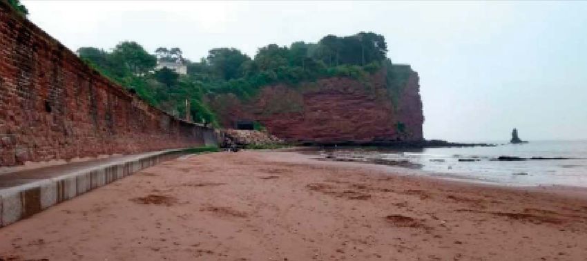
The Network Rail (Parson’s Tunnel to Teignmouth Resilience) Order
Project Overview for Public Consultation

      2016: Network Rail commissioned the engineering company CH2M Hill (now a part
1.3.2
      of Jacobs) to conduct a study into the future options for the route between Exeter and
      Newton Abbot.

1.3.3	The Exeter to Newton Abbot Resilience Geo-Environmental Resilience Study detailed
       the options considered from 2014 and identified three priority sites which required
       works to deliver a resilient railway:

         • Between Parson’s Tunnel and Teignmouth, where there was a landslip on the cliffs
            in 2014

         •T
           he Seawall at Dawlish

         •T
           he cliffs to the north of Parson’s Tunnel

	The study established that unless a series of short, medium and long-term measures
  were put in place, extreme weather, coastal erosion and sea level rises would result in
  the type of events that closed the line in 2014 occurring more frequently. The first of
  these priority sites relates to this project. The report made recommendations for two
  options for Parson’s Tunnel to Teignmouth to be taken forward for further analysis:

         1. To regrade the cliffs (cutting away rock to reduce the steepness)

         2. To relocate the railway line away from the cliff

1.3.4	The report concluded that regrading the cliffs would require a significant amount of
       rock to be cut away and removed from site – an operation that was calculated to take
       between six to 12 months during which time the railway would need to be closed.
       Further work has since established that a significant amount of land at the top of the
       cliffs – some from private properties and, potentially, a section of the main road from
       Dawlish to Teignmouth – would be required for permanent acquisition. The impact on
       private property, the natural environment and the railway meant this option was not
       considered further.

1.3.5	The CH2M reports can be found in the links below:

	Phase 1 Report
  https://cdn.networkrail.co.uk/wp-content/uploads/2018/11/Exeter-Newton-Abbot-
  Phase-1-Baseline-Report.pdf

	Phase 1 Appendices
  https://cdn.networkrail.co.uk/wp-content/uploads/2019/08/Exeter-Newton-Abbot-
  Resilience-Strategy-Phase-1-Appendices-CH2M-2016.pdf

                                                    9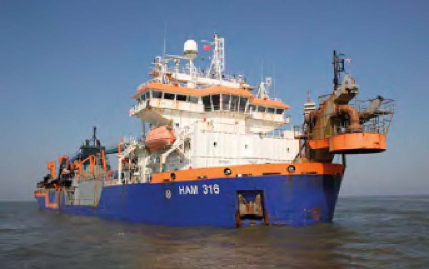
The Network Rail (Parson’s Tunnel to Teignmouth Resilience) Order
Project Overview for Public Consultation

         Drone survey report
         https://cdn.networkrail.co.uk/wp-content/uploads/2019/12/Dawlish-Teignmouth-Cliffs-
          Unmanned-Aerial-Vehicle-UAV-Survey-Interpretation-Report.pdf

         Ground investigation report
         https://cdn.networkrail.co.uk/wp-content/uploads/2019/12/Exeter-to-Newton-Abbot-
          Resilience-Study-Phase-1-–-Ground-Investigation-Report.pdf

	Phase 2 report
  https://cdn.networkrail.co.uk/wp-content/uploads/2019/04/Exeter-Newton-Abbot-
  Phase-2-Option-Assessment-Report.pdf

         Phase 2 appendices
          https://cdn.networkrail.co.uk/wp-content/uploads/2019/08/Exeter-Newton-Abbot-
          Resilience-Strategy-Phase-2-Appendices.pdf

         Phase 3 reports
         https://cdn.networkrail.co.uk/wp-content/uploads/2018/11/Exeter-Newton-Abbot-
          Phase-3-Option-Selection-Report.pdf

1.4      Options considered in 2018

1.4.1	In April 2018, Arcadis was appointed to further develop the options for Parson’s
       Tunnel to Teignmouth, carry out site investigations and develop outline designs. It was
       this work that took the high level ‘reclamation’ solution proposed in 2016 and made
       it bespoke for each ‘Cliff Behavioural Unit’ (CBU). That led to the railway alignment
       coming in significantly and the land take being much less than it would have been
       if based on the 2016 study. This was, in part, due to feedback on the proposals
       from local residents. So, the high level concept of ‘reclaming land to make space for
       one full‑length toe buttress’ was refined and developed so that a number of different
       cliff stabilisation techniques could be employed, ranging from a rockfall shelter (just
       south of Parson’s Tunnel) through cliff dowelling to buttresses in the highest risk CBUs.
       This has led to a reduction in land reclamation.

1.4.2	In November 2018, Network Rail undertook an internal Option Selection Workshop,
       where numerous options were revisited in the light of more detailed surveys and
       investigations carried out during the outline design phase. The workshop goals
       were to verify the most feasible option and challenge the reasons for discarding
       the alternatives and reviewing alternatives suggested during the 2016 public
       engagement events.

                                                    10
The Network Rail (Parson’s Tunnel to Teignmouth Resilience) Order
Project Overview for Public Consultation
1.4.3 The workshop concluded that the proposed development of a new coastal defence,
realigned railway, land reclamation and buttresses at the toe of the cliffs (detailed in
Section 3 of this document) was the most feasible and therefore preferred option to
take forward.
1.4.4 The key reasons identified for this option being taken forward are:
• The resilience benefits offered in terms of mitigating global and other deep-seated
failure modes.
• The ability to construct the Scheme without significant duration of railway
line closures
• The opportunities available to offset the environmental impact through provision of
alternative amenity and environmental enhancements.
1.4.5 Below is a synopsis of the other options that were reconsidered in the 2018 study and
the reasons for not taken them forward.
Maintaining existing measures – Parson’s Tunnel to Teignmouth
• Continuation of the existing repair and maintenance operations is not sustainable in
the long term as the level of risk and disruptions will increase as outlined in section
one of this document. The increasing risk of a catastrophic failure on an operational
line is unacceptable.
• The cliff and coastal defence structures require additional and ongoing maintenance
works to provide continued “right of support” to properties at the top of the cliffs.
Provision of additional Cliff Drainage – Parson’s Tunnel to Teignmouth
• Cliff drainage does not address the most significant hazard to the railway operations
– deep-seated cliff failure (global or compound wedge failure).
• Provision of cliff drainage alone does not provide a robust enhancement to the long-
term resilience of the railway operations.
• Cliff drainage has been incorporated into the scheme proposed in this consultation.
Incorporating the railway line within a tunnel in a toe buttress at the foot of the
cliffs – Parson’s Tunnel to Teignmouth
• This option would require the line to be closed for a significant period
during construction.
• The additional cost and programme implications of such a tunnelled route are
greater than the proposed works.
11The Network Rail (Parson’s Tunnel to Teignmouth Resilience) Order
Project Overview for Public Consultation
Alternative Route – Local Tunnel (inland) Dawlish Warren to Teignmouth
•T
his option removes the existing mainline service from the currently supported
communities and is outside of Network Rail’s remit.
•T
he cost and programme implications of such a tunnelled route are greater than the
works identified within the current Geo-Environmental Resilience Strategy.
• The
cliff and coastal defence structures require additional and ongoing maintenance
works to provide continued “right of support” to properties at the top of the cliffs
Alternative Route – Local Viaduct between Dawlish Warren and Teignmouth
• The cost, programme and environmental implications of provision of a viaduct
are greater than the works identified within the current Geo-Environmental
Resilience Strategy.
•T
his option removes the existing mainline service from the currently supported
communities and is outside of Network Rail’s remit.
• The
cliff and coastal defence structures require additional and ongoing maintenance
works to provide continued “right of support” to properties at the top of the cliffs
Alternative Route – Local Viaduct between Parson’s Tunnel and Teignmouth
•T
he construction of the piled viaduct would have significant cost and environmental
impacts owing to the need for marine based piling into rock.
•T
he cliff and coastal defence structures require additional and ongoing maintenance
works to provide continued “right of support” to properties at the top of the cliffs.
Rockfall Shelter/s – Parson’s Tunnel to Teignmouth
•A
rockfall structure does not address the most significant hazard to the railway
operations, which is a deep-seated cliff failure.
•T
he cliff requires additional and ongoing maintenance works to provide continued
“Right of Support”.
Cliff Regrade – Parson’s Tunnel to Teignmouth
•T
he significant construction impacts on the local community and wider rail users
that would be cut off from the main rail network due to the need to close the railway
line for a significant duration during construction thus in direct contradiction of
the purpose of the project (improving resilience to maintain this vital rail network
connection to the south west).
12The Network Rail (Parson’s Tunnel to Teignmouth Resilience) Order
Project Overview for Public Consultation
•T
he requirement for compulsory purchase of significant areas of property and land
(including a main highway) to achieve the scheme.
2018-19: Geotechnical studies were undertaken in 2018 to evaluate the physical
properties of cliff soil and rock to identify any structural issues and evaluate distress,
weakness or failure in subsurface materials. This included taking rock samples from
deep within the cliffs, the beach and the seabed, which were further divided into
factual reports detailing the viability of the cliff from crest to toe. The reports comprise
various constituent parts including:
Geotechnical Report – Cliff Toe – This report details information regarding
masonry cores, Inspection Pits, and dynamic probing of the Cliff Toe.
Geotechnical Report – Cliff Top – This report details the location and composition of
each borehole along the project area. Each borehole is pictured and studied to better
understand the ground conditions.
It is from this extensive data that Network Rail was able to progress with the proposals
being presented in this consultation.
13The Network Rail (Parson’s Tunnel to Teignmouth Resilience) Order
Project Overview for Public Consultation
Proposed Development
1.5 Introduction
1.5.1 The 1.8km section of railway between Parson’s Tunnel and Teignmouth is bordered by
steep cliffs on one side and the sea on the other. Network Rail is proposing to realign
the track to make room for corrective measures to stabilise the cliffs and protect
the railway for future generations. Network Rail intends to reclaim a platform of
land seaward of the existing Seawall to allow cliff stabilisation works to be installed
between Parson’s Tunnel and Teignmouth (‘the site’).
1.5.2 The Parson’s Tunnel to Teignmouth Resilience Project (hereafter referred to as ‘the
proposed development’), includes cliff stability works (buttressing, deep dowels, rockfall
shelters and netting), new coastal defences, a realigned coastal footpath and a revised
railway alignment.
1.6 New Coastal Defence
1.6.1 A new coastal defence measuring approximately 1.9km in length will be installed on
the seaward side of the existing structure. This new coastal defence will have two
distinct elements, a new raised Seawall and sections of revetment (a sloping structure
constructed on the shoreline to absorb the energy of the waves).
New Seawall
1.6.2 In order to minimise the beach take at Holcombe Bay, a near vertical Seawall (550m
in length) will be constructed from Parson’s Tunnel south portal to the northern extent
of a new revetment (1.6.6).
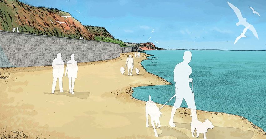
Figure 1.1 – Holcombe Beach and the existing Seawall looking towards Parson’s Head
14The Network Rail (Parson’s Tunnel to Teignmouth Resilience) Order
Project Overview for Public Consultation
1.6.3 A further section of Seawall approximately 600m in length will run from the southern
extent of the revetment to a point in front of Teignmouth Cutting where it will tie in
to the existing Teignmouth Seawall. It will be adjacent to Teignmouth Town Beach, to
minimise beach loss and any potential impact on the protected Church Rocks Wreck,
which lies offshore.
1.6.4 The new raised Seawall will stand approximately 8m above current beach levels, which
is 2.5m higher than the existing structure. This increase in height provides rail resilience
and pedestrian protection due to climate change predictions for rising sea levels over
the 100-year design life of the new coastal defence.
1.6.5 The new Seawall parapet will include a recurved wave return profile on the seaward
face. This curved top is designed to reflect wave energy back to sea and reduce
wave overtopping.
Figure 1.2 – Teignmouth Beach and the proposed Seawall looking towards Sprey Point
Revetment
1.6.6 In the central area between the two new sections of Seawall, a revetment approx.
750m in length will be constructed. This will extend 28.4m out from the current
Sprey Point. The proposal for a revetment in the central section rather than a
continuous Seawall, provides a higher level of protection against wave overtopping
to pedestrians around the proposed new Sprey Point viewing platform (detailed in
Section 1.12).
15The Network Rail (Parson’s Tunnel to Teignmouth Resilience) Order
Project Overview for Public Consultation
1.6.7 The decision for the location and extent of the new Seawall is based on maximising
retention of accessible beach area and avoidance of the exclusion zone around the
protected Church Rocks Wreck.
1.6.8 In addition to the central section of revetment, a smaller secondary rock revetment will
be installed in front of the new Seawall adjacent to the Parson’s Tunnel south portal.
This structure will replace the existing short section of rock revetment (as shown
in Fig. 1.3 below) protecting the original Seawall and the railway from wave action
and overtopping.
Figure 1.3 – Existing rock revetment adjacent to Parson’s Tunnel
1.6.9 A revetment is a porous structure consisting of an outer layer of primary armour over
a secondary armour layer (called the underlayer). Beneath the underlayer there is
typically a mound of finer material called the core. The primary armour layers are
designed to absorb wave energy and reduce wave run-up, whilst remaining stable in
storm conditions.
1.6.10 The proposed revetment has a sloping face constructed with a 1:2 gradient (1
vertical to 2 horizontal) as shown in Figure 1.4. The revetment slope will assist in
creating replacement intertidal areas (where the sea meets the land between low and
high tides) and opportunities for habitat creation in the central section, in addition to
absorbing wave energy.
16The Network Rail (Parson’s Tunnel to Teignmouth Resilience) Order
Project Overview for Public Consultation
Figure 1.4 – Revetment Option Typical Section
1.7 Land Reclamation
1.7.1 The area of land lying between the new coastal defence and the original Seawall
structure will be infilled with suitable material to enable the railway to be relocated
away from the base of the cliffs.
1.7.2 The design minimises the amount of land that needs to be reclaimed by:
a) only moving the railway away from the most potentially hazardous areas of the cliffs
b) keeping the existing railway alignment at both Parson’s Tunnel and
Teignmouth cutting
c) t he new coastal path will not extend any further out than the current extent of
Sprey Point.
1.7.3 By sweeping out from part way along the beaches either side of Sprey Point, the total
amount of land required to be reclaimed is minimised. This will enable public access to
Holcombe and Teignmouth beaches to continue.
1.7.4 In total 53,829m2 will be reclaimed. This equates to 4.98 football pitches (120m x 90m).
1.7.5 Due to the gradual realignment, the actual length of walkable beach at mean low tide
will be more than 1100m (1150m – c550m Holcombe and c600m on Teignmouth
sides of Sprey Point) with access up to the South West Coast Path, in between, as is
the case today. In addition, more than 1000m of new path (1086m) with full coastal
views will be added to the landward side of the railway. The new enhanced coastal
path (1910m long) will be 1m wider than the present path and also provide a parapet
to prevent falls from height. In addition, the viewing area at Sprey Point will be
significantly enhanced. With full accessibility built in, this scheme will retain as much
of the beach as possible whilst improving access to this section of the South Devon
coastline for those with reduced mobility.
17The Network Rail (Parson’s Tunnel to Teignmouth Resilience) Order
Project Overview for Public Consultation
1.7.6 Material for the land reclamation will be imported from an offshore dredging site
located close to the Isle of Wight. The material will then be mixed with seawater to be
pumped ashore through a pipeline running along the seabed. Once discharged from
the pipeline, the material is then dewatered onsite.
1.7.7 The dewatered material will be compacted to reach the required strength and stability
to support the railway line.
1.7.8 At the tie-in sections where the new coastal defence interfaces with the existing
railway structures, concrete will be used to infill the gap between the two structures.
1.8 Railway Realignment
1.8.1 We propose to realign the tracks to make room for corrective measures to stabilise the
cliffs and protect the railway for future generations.
1.8.2 The design and construction methodology have been developed to keep the railway
operational for much of the construction period. To achieve this, the new section
of railway and associated signalling, telecommunications and drainage will be
constructed on the reclaimed land whilst the existing line remains open to passenger
and freight trains.
1.8.3 We will then undertake works to tie the new section of railway into the existing
alignment at Teignmouth Cutting and Smugglers Bridge. Once the tie-in works are
completed the train services will operate on the realigned route.
1.8.4 The old railway infrastructure will be removed to clear the area ready for the
installation of the cliff stability works.
1.9 Cliff Stability (buttressing, dowels, rockfall shelter)
1.9.1 As outlined earlier in this document, Network Rail identified multiple ways the
cliffs between Parson’s Tunnel and Teignmouth could fail including: a global failure,
compound wedge, shallow slip, washout, rockfall and erosion over the next 100 years.
18The Network Rail (Parson’s Tunnel to Teignmouth Resilience) Order
Project Overview for Public Consultation
1.9.2 The cliffs have been split into individual elements called Cliff Behavioural Units (CBU)
due to the differing geotechnical characteristics and potential failure modes. The
CBUs have been numbered from 1 to 15, with CBU1 being Teignmouth Cutting and
CBU15 Parson’s Tunnel South Portal.
1.9.3 Our design proposes multiple solutions applied to each CBU, including buttresses,
deep dowels, soil nails, rockfall shelter and drainage to solve the many failure modes
that are present in the cliffs.
Figure 1.5 – Location of Cliff Behavioural Units
Buttress
1.9.4 Buttresses are formed by compacting material in layers with the insertion of geogrids
at set intervals. This build-up of material forms a buttress structure. The front face will
have an erosion mat installed that protects the buttress and permits vegetation to
grow to the front face of the slope.
1.9.5 Buttresses are proposed at five of the sections of cliffs
Approximate buttress heights:
• CBU4 – 33m
• CBU6 – 32m
• CBU8 – 21m
• CBU10 – 20m
• CBU12 – 23m
Figure 1.6 – Buttresses shown behind railway line
19The Network Rail (Parson’s Tunnel to Teignmouth Resilience) Order
Project Overview for Public Consultation
Deep Dowels
1.9.6 These are round steel bars installed (drilled and grouted) in to the cliff face to
improve stability. It is currently envisaged that these dowels could be up to 30m deep.
These will mainly be installed above the buttresses and where it is not possible to
provide a buttress (i.e. CBU2 and 13).
Soil Nails
1.9.7 Soil nails are a widely used technique for stabilising a cliff face. They involve the
installation of a hollow steel bar, grouted into position, which reinforces unstable
ground and anchors it to stable material behind. This will be mainly completed above
the deep dowels, at the top of the cliff.
Rockfall Shelter
1.9.8 The rockfall shelter will extend from the south portal of Parson’s Tunnel for a length of
approximately 12m. The structure will consist of pre-cast concrete portals with pre-
stressed reinforced concrete box beams spanning between each frame. An in-situ
reinforced concrete layer will sit on the pre-cast roof of the structure. Approximately
1m of sand will be added to the structure to absorb the impact of any rockfall and
distribute the load.
Figure 1.7 – Parson’s Tunnel south portal rockfall shelter
Drainage
1.9.9 Drainage will be improved site wide, through the installation of channels at regular
intervals in the cliff face to catch existing drainage and help manage the groundwater
levels in the cliff.
20The Network Rail (Parson’s Tunnel to Teignmouth Resilience) Order
Project Overview for Public Consultation
1.10 Smugglers Lane/Bridge Redevelopment
1.10.1 The proposed development will create a step-free ramp from the end of Smugglers
Lane down to Smugglers Bridge and will utilise the arches to pass under the railway.
A 3m wide ramp will be installed on the inside of the new Seawall running in a
southward direction from Smugglers Bridge up to promenade level. This will be
the realigned route of the South West Coast Path from Smugglers Lane to the
Seawall promenade.
Figure 1.8 – Smugglers Bridge
1.10.2 Once at promenade level, users will have two options; either carry on along the South
West Coast Path to the new Sprey Point or descend down a ramp to Holcombe beach.
This ramped structure includes a 1.1m parapet with wave return profile on the
seaward facing side.
1.10.3 All new ramps will be designed for people with restricted mobility (including handrails),
non-slip surfacing and 1 in 20 gradients.
1.10.4 A new amenity area will also be created on the landward side adjacent to where
the new ramp descends from Smugglers Lane. Network Rail is currently developing
options for how this area could be used and suggestions are welcome as part of
this consultation.
1.10.5 This amenity area will be made up of a small section of reclaimed land which will
be supported by a retaining wall. This area of land will be used to create the shared
access route for pedestrians and Network Rail maintenance vehicles between the
railway and the base of the cliffs.
21The Network Rail (Parson’s Tunnel to Teignmouth Resilience) Order
Project Overview for Public Consultation
1.11 Realigned South West Coast Path and new landward footpath
1.11.1 The new Seawall promenade will be a minimum of 3m wide with a 1.1m high parapet
on the seaward side. On the railway side of the promenade there will be a 0.6m
high concrete upstand wall with a 1.4m high fence on top to stop access onto the
operational railway. At intervals of 50m along the promenade, prefabricated concrete
benches will be inset within the concrete upstand wall for leisure walkers.
Figure 1.9 – Seawall promenade (between railway and beach)
1.11.2 On the landward side of the railway, a new 1km (1086m) pathway will be created
running along a terrace within the buttressing installed to support the cliffs. The
elevation of the new path means users will have full coastal views. This path will also
be 3m wide and will have a 1.1m high fence running along the outside edge. The
footway will be surfaced with a porous/free-draining granular material.
Figure 1.10 – Landward path on buttress. Teignmouth sign shown
1.11.3 Access to the landward path will be via the shared access route (see 1.10) created at
Smugglers Lane and a new footbridge located at the southern extent of Sprey Point
(see 1.12).
22The Network Rail (Parson’s Tunnel to Teignmouth Resilience) Order
Project Overview for Public Consultation
1.11.4 The footbridge and the new route beneath Smugglers Bridge create a new circular
walking route, approximately 3.6km long, utilising the Seawall promenade and
landward path.
1.11.5 The landward path will not be classified as a public right of way, as Network Rail will
be required to occasionally close the path for maintenance and the cliff stability works
(see 1.9). The realigned South West Coast Path will be created by diverting the two
current public rights of way (Dawlish Footpath No.12 and Teignmouth Footpath No.6)
onto the alignment of the new coastal defence.
1.11.6 There are currently two separate private rights of access that traverse down the cliffs
and cross the railway. Within the proposed development these rights will be diverted
down the new buttressing and join with the landward path before being carried over
the railway via the proposed footbridge at Sprey Point. Access will then continue to
the beach using the South West Coast Path and the stepped or ramped accesses to
beach level.
1.12 Sprey Point (inc. viewing platform and footbridge)
1.12.1 The proposed development of Sprey Point includes a widened promenade area behind
the central rock revetment. The existing Sprey Point will be included within the land
reclamation area required to support the realigned railway.
1.12.2 The new coastal path will not extend any further out than the current extent of
Sprey Point. In this central section the width of the coastal path will expand from
3m to 15m for a length of 100m. Network Rail also plans to raise the height of the
promenade in this area so that the parapet height is reduced to 0.9m, providing better
visibility over the coastal defence for small children and people with reduced mobility.
Figure 1.11 – Sprey Point
23The Network Rail (Parson’s Tunnel to Teignmouth Resilience) Order
Project Overview for Public Consultation
1.12.3 Benches and picnic tables will be provided to make Sprey Point a destination at the
midway point between Holcombe and Teignmouth.
1.12.4 At the southern end of Sprey Point, a footbridge will be installed to connect the
seaward promenade and the new landward path. The footbridge will have both
ramped and stepped access on the seaward side and will land directly onto the
buttress on the landward side to provide level access.
1.12.5 The proposed footbridge will be located at the southern end of Sprey Point for two
main reasons:
1. T
here is insufficient space at the Teignmouth end of the proposed development
due to the railway alignment having to tie in to the existing Teignmouth Cutting
below Eastcliff Bridge and avoid the protected Church Rocks Wreck located
close offshore.
2. T
he new footbridge will also carry two private rights of access which currently cross
the railway on the level at either end of the existing Sprey Point.
1.13 Other Ecological Mitigation Proposals
Habitat Creation
1.13.1 As part of the proposed development, Network Rail is working with the relevant
statutory bodies (including Natural England, Environment Agency, Marine
Management Organisation) to identify where new marine and terrestrial habitats can
be created or improved to mitigate the potential impacts of the works.
1.13.2 We have recently identified the new revetment as a potential intertidal habitat
and the buttresses and reclaimed land behind the realigned railway as having the
potential to create new terrestrial habitats.
24The Network Rail (Parson’s Tunnel to Teignmouth Resilience) Order
Project Overview for Public Consultation
2. Outline Construction Methodology
2.1 Introduction
2.1.1 Network Rail has commissioned Arcadis to engage Alan Griffiths Contractors Limited
and Van Oord UK Limited to provide construction advice, in respect of the proposed
development detailed in this document.
2.1.2 Below is a synopsis of the following key stages of the proposed development:
• Mobilisation
• Coastal Defence Construction
• Land Reclamation
• Rail Systems
• Cliff Stability Works
• Amenity Works
2.1.3 The construction activities detailed below are listed sequentially in the order work is
anticipated to commence, although there will be overlapping activities due to the
construction timescales. Please note, this may change following detailed design and
the programming undertaken by the construction contractors (once appointed).
2.2 Mobilisation
2.2.1 This period of the programme can be broken down into three distinct sections:
Setting Up Site Compounds
2.2.2 Establishing a compound for staff welfare facilities is the first step within the
construction programme. These compounds will include project offices, parking
and material laydown areas. Network Rail has identified three locations to house
these facilities: Teignmouth Docks, a site on Teignmouth Road, and a site on Sprey Point.
Bringing Plant and Materials to Site
2.2.3 There will be many different types of construction plant on site, such as landing craft,
piling rigs, long-reach excavators, and lifting equipment. Each method of delivery
considers its impact on local highways, operational railway and tidal dependency.
Network Rail is currently exploring options for a temporary offshore facility
to assist with this process. This will be considered and included within the
Environmental Statement.
25The Network Rail (Parson’s Tunnel to Teignmouth Resilience) Order
Project Overview for Public Consultation
Installing a Concrete Batching Plant
2.2.4 During construction, sizeable quantities of concrete will be required. To reduce the
impact on local highway infrastructure, overall carbon footprint and enable a faster
construction sequence, a concrete batching plant will be installed at Sprey Point.
2.3 Coastal Defence construction
Parson’s Tunnel
2.3.1 A combination of revetment and Seawall are proposed to enable the rockfall shelter
construction adjacent to the Parson’s Tunnel south portal.
2.3.2 To allow for this, the current revetment will be removed, including the pillbox that
stands on top. Concrete foundations and precast units will then be installed to create
the new Seawall. Once complete, the ramps for beach access can be created.
2.3.3 A revetment will then be constructed in front of the new Seawall to protect the
junction between the Seawall and the cliff from erosion.
Revetment construction
2.3.4 In the central section, a sloping revetment will be constructed. This will be made up of
three separate layers: the core material, moving to an underlayer material and finally
on the outside a primary layer.
2.3.5 The central revetment will be c750m long and will be created by digging up from the
seabed with a backhoe dredger. The material taken from the seabed will then be used
along the revetment to form part of the core layer of material.
Figure 2.1 – Backhoe dredger and support barge
26The Network Rail (Parson’s Tunnel to Teignmouth Resilience) Order
Project Overview for Public Consultation
2.3.6 The revetment materials will be delivered by sea to allow for large quantities at a
time to be delivered and limit the impact on road and rail networks. This means less
noise pollution to nearby residents and, with larger vessels, reduced carbon footprint
through reduced journeys.
Seawall construction
2.3.7 Proposed new Seawall foundations will be required to enable laying the pre-cast
concrete Seawall units. The Seawall will be comprised of pre-cast units that will be
installed into location and secured with cranes.
2.3.8 Precast concrete units stored at Teignmouth Docks will be transported via a support
vessel to the site including the Seawall and revetment promenade wall sections.
The Seawall will be approximately 3m wide and form the base of the new South West
Coast Path.
2.3.9 At this stage public access to the beach will be limited as there will be moving plant
(heavy machinery), deep excavations and construction conditions.
Land Reclamation
2.3.10 This stage of the works will form a core part of the proposed development and
involve dredged material transported to site (behind the newly constructed Seawall
and revetment) via a pipe laid along the seabed.
Figure 2.2 – Trailing Suction Hopper Dredger
2.3.11 Offshore delivery could be affected by tidal conditions and weather, and therefore
careful planning to maintain the programme would be required at this stage.
27The Network Rail (Parson’s Tunnel to Teignmouth Resilience) Order
Project Overview for Public Consultation
2.3.12 Once the land reclamation has been completed, ground improvement works will be
required to ensure that the new land is considered stable and fit to support the new
railway infrastructure and coastal path.
2.3.13 The reclamation of land may require 24-hour working.
Parson’s Tunnel south portal rockfall shelter
2.3.14 Following the construction of the Smugglers Lane Seawall and revetment, a rockfall
shelter will be constructed in front of Parson’s Tunnel south portal.
2.3.15 The rockfall shelter will be constructed from precast concrete sections which will be
delivered to site via a supply barge.
2.3.16 Once the frame is complete, a concrete cast topping deck can be poured to finalise
the structure. The rockfall shelter will then have an infill of concrete between the
structure and cliffside.
Footbridge Foundations and Supports
2.3.17 Following completion of the land reclamation the piled foundations for the footbridge
linking the seaward and landward sides of the railway will be installed into the Seawall.
2.3.18 The footbridge supports will be designed to be used during the construction of the
buttress (see 1.9) to carry a temporary conveyor belt over the railway.
2.3.19 The footbridge foundation works can be constructed without impacting the operation
of the railway.
Smugglers Lane/Bridge Redevelopment
2.3.20 A retaining wall has been proposed for a section of railway adjacent to the south
of Smugglers Bridge to raise the elevation of the combined amenity walkway/
vehicular track. The increased elevation is required to increase the horizontal clearance
to the cliff to achieve a full width walkway.
2.3.21 The retaining wall will be cast in situ using concrete from the Sprey Point
batching plant.
2.3.22 The existing water course outfall will be diverted via a 500mm diameter pipe through
the new Seawall to outfall on to the foreshore.
2.3.23 Once the watercourse has been diverted a 2m wide ramp will be cast in situ to connect
the higher-level Smugglers Lane with the underpass beneath Smugglers Bridge.
28The Network Rail (Parson’s Tunnel to Teignmouth Resilience) Order
Project Overview for Public Consultation
2.3.24 The area beneath the bridge and adjacent to the new ramp will be excavated and
attenuation tanks installed below permeable paving to allow rainwater and any
seawater that overtops the Seawall to be collected and drained back to the foreshore
via a pipe.
2.4 Rail Systems
Railway, Signalling, Drainage and Telecommunications
2.4.1 Following completion of the ground stabilisation works, the new sections of railway
infrastructure will be constructed. The railway works will be built up sequentially
from sub-base to track formation level using material imported to site.
2.4.2 Most of these works can be installed without impacting the existing railway. The
only exception being the final tie-in connections at Teignmouth Cutting and
Smugglers Bridge, which will be undertaken during a short railway closure (Easter
or Christmas are the usual times when Network Rail can close the railway for
this duration).
2.4.3 Once completed the railway will operate on the new alignment. At this point we
anticipate that it will be possible to reopen the South West Coast Path.
2.5 Cliff Stability Works
Buttresses
2.5.1 There is approximately 550,000m3 of material required for the construction
of the buttresses, which will come from the same site as material used for the
land reclamation.
2.5.2 The buttresses will be built in layers and the front face cut to give the finished profile.
Deep Dowels
2.5.3 The cliffs adjacent to the tie-in sections of the old and new railway alignments require
deep dowels to be installed across the full face of the cliff as there is insufficient space
to install buttressing.
2.5.4 The deep dowels will be installed using hydraulic drilling rigs.
2.5.5 The hydraulic drilling rig will drill up to 30m into the cliff and install a hollow steel
dowel which is then grouted into position, this will pin the cliff face to deeper rock
within the cliff.
29The Network Rail (Parson’s Tunnel to Teignmouth Resilience) Order
Project Overview for Public Consultation
2.6 Amenity Works
Footbridge Construction
2.6.1 A fibre-reinforced plastic (FRP) footbridge has been proposed at Sprey Point, to span
the railway and connect the South West Coast Path with the new landward footpath.
2.6.2 A concrete ‘bank seat’ will be designed to support the bridge on the buttress. The bank
seat will be of reinforced concrete construction.
2.6.3 The deck, steps and ramps will be installed following the completion of the bank seat
and supports.
2.6.4 The footbridge comprises two FRP U-frame deck spans which will be supported by
reinforced concrete columns and the cliffside bank seat on the buttress.
2.6.5 Once delivered to site the prefabricated FRP units will be lifted into place. The
footbridge deck will have lifting points included in its design. The largest span is
six tonnes and approximately 16.5m in length.
Maintenance track and landward footpath
2.6.6 Following the completion of the large-scale civils and ground works, the final ancillary
civils works can be completed. This will involve the final touches to the access and
amenity works including walkways, maintenance track, fencing/gates and signage.
Catch Fence
2.6.7 A catch fence has also been proposed for the length of CBU13 (the cliff face directly
south of Smugglers Bridge) adjacent to the landward footpath, to provide additional
protection from any loose material which may fall through the cliff face netting.
30The Network Rail (Parson’s Tunnel to Teignmouth Resilience) Order
Project Overview for Public Consultation
3. Environmental Impact Assessment (EIA)
3.1 Introduction
3.1.1 Due to the nature of the proposed development, Network Rail is required to
undertake an Environmental Impact Assessment in accordance with the relevant
statutory regimes, which for this project are the Marine Works (Environmental
Impact Assessment) Regulations 2007 (as Amended) and The Transport and Works
(Applications and Objections Procedure)(England and Wales) Rules 2006.
3.1.2 The scope of the EIA therefore needs to cover potential impacts that could give rise to
‘likely significant effects’ on both terrestrial and marine environments.
3.2 EIA Process
3.2.1 The aim of an EIA is to assess any likely significant effects the proposed development
will have on the environment and to identify appropriate mitigation measures to
minimise any identified impacts.
3.2.2 This assists the decision-maker, in this case the Secretary of State for Transport, when
deciding whether to grant permission for the project.
3.2.3 In general terms, the main stages in preparing the EIA are as follows:
• Data Review – draw together and review available data.
•S
coping – setting the subject matter of the EIA and undertaking consultation with
required consultees to obtain feedback on the scope of the assessment, any relevant
baseline considerations and approach to methodology.
•B
aseline surveys and data collection – undertake baseline surveys and desk studies
to identify existing conditions.
•A
ssessment and iteration – assess likely effects of the proposed development,
identify reasonable alternatives, provide feedback to the design team on
any adverse impacts, incorporate mitigation and assess the effects of the
mitigated development.
•S
ubmission and consultation of the EIA as part of the consenting process.
3.3 EIA Scoping Report and Scoping Opinion
3.3.1 Network Rail has commissioned Arcadis to undertake the EIA in accordance with the
Marine Works and The Transport and Works Rules.
31The Network Rail (Parson’s Tunnel to Teignmouth Resilience) Order
Project Overview for Public Consultation
3.3.2 As part of these processes Network Rail produced an EIA Scoping Report https://
consultations.networkrail.co.uk/communications/swrrp/supporting_documents/
Environmental%20Impact%20Assessment%20%20Summary.pdf and requested an
EIA Scoping Opinion from the Secretary of State for Transport (SoS) and the Marine
Management Organisation (MMO). The Department for Transport, on behalf of
the SoS, have consulted with the MMO and other statutory organisations, and on the
20 September 2019 provided Network Rail with the SoS EIA Scoping Opinion.
3.3.3 Table 5.1 below summarises the proposed scope of the EIA for the Parson’s Tunnel to
Teignmouth Resilience works.
Environmental Topic Scoped In Scoped Out
Terrestrial Ecology Construction Impacts
Operational Impacts
Benthic Ecology Construction Impacts
Operational Impacts
Fish & Shellfish Ecology Construction Impacts
Operational Impacts
Marine Mammals Construction Impacts
& Marine Birds Operational Impacts
Landscape Construction Impacts
Operational Impacts
Cultural Heritage Construction Impacts
Operational Impacts
Air Quality Construction Impacts – Dust Construction Impacts –
Odour
Operational Impacts
Noise & Vibration Construction Impacts – Land Operational Impacts –
based noise Vibration
Construction Impacts –
Marine noise
Construction Impacts –
Marine vibration
Operational Impacts – Noise
Coastal Processes Construction Impacts
Operational Impacts
32The Network Rail (Parson’s Tunnel to Teignmouth Resilience) Order
Project Overview for Public Consultation
Environmental Topic Scoped In Scoped Out
Ground Conditions Construction Impacts Operational Impacts
Water Resources Construction Impacts – Operational Impacts – Water
Water quality quality
Construction Impacts –
Flood risk and drainage
Construction Impacts –
Surface & groundwater
resources
Operational Impacts – Flood
risk & drainage
Operational Impacts –
Surface & groundwater
resources
Transport Construction Impacts
Operational Impacts
Other Marine Users Construction Impacts
Operational Impacts
Resources & Waste Construction Impacts Operational Impacts
Climate Change Construction Impacts – Operational Impacts –
Greenhouse gases Greenhouse gases
Construction Impacts –
Climate change adaption
Operational Impacts –
Climate change adaption
Socio-economics & Health Construction Impacts
Operational Impacts
Tourism & Recreation Construction Impacts
Operational Impacts
Agriculture & Soils Construction Impacts Operational Impacts
Table 3.1 – Parson’s Tunnel to Teignmouth EIA Scope
33The Network Rail (Parson’s Tunnel to Teignmouth Resilience) Order
Project Overview for Public Consultation
3.4 EIA Consultation
3.4.1 Following receipt of the SoS EIA Scoping Opinion, Network Rail is consulting with
the following statutory and non-statutory bodies to finalise the scope of the
baseline surveys, assessment methodologies and proposed mitigation:
• Department for Transport
• Marine Management Organisation
• Environment Agency
• Natural England
• Historic England
• Devon Wildlife Trust
• Devon and Severn Inshore Fisheries and Conservation Authority
• Sea Mammal Research Unit
• British Trust for Ornithology
• Whale and Dolphin Conservation
• Teignbridge District Council
• Devon County Council
• Royal Yachting Association
• Local Harbour Authority (Teignmouth Harbour Commission)
• Trinity House
• Maritime and Coastguard Agency
• The Crown Estate
3.5 Environmental Statement
3.5.1 The results of the EIA will be compiled and presented within an Environmental
Statement (ES), which will support Network Rail’s application for a Transport and Works
Act Order.
34The Network Rail (Parson’s Tunnel to Teignmouth Resilience) Order
Project Overview for Public Consultation
3.5.2 The structure of the ES has been determined following scoping and consultations
and comprises:
• Volume 1: Environmental Statement (Main Text);
• Volume 2: Environmental Statement Figures;
• Volume 3: Technical Appendices; and
• Volume 4: Non-Technical Summary.
3.6 Additional Documents
3.6.1 Additional documents to the ES will be prepared as part of the TWAO and Marine
Licence applications and provide supplementary information outside of the EIA process.
These include the following:
• Sustainability Statement
• Equalities Impact Assessment
• Habitats Regulation Screening Assessment
• Water Framework Screening Assessment
35The Network Rail (Parson’s Tunnel to Teignmouth Resilience) Order
Project Overview for Public Consultation
4. Public Consultation
4.1 Introduction
4.1.1 Network Rail recognises the importance of early and active engagement with both
statutory and non-statutory consultees in developing a scheme design that fits the
social and environmental needs of the local community.
4.1.2 Feasibility studies with early concepts were presented to the public in 2016 via various
forums including the Teignbridge Locality Committee and Holcombe Residents
Association meetings. Since then we have refined the proposals as a direct result of
the public feedback we received. From 10 June – 15 July 2019 the first round of public
consultation took place in the Dawlish, Holcombe and Teignmouth area. This was
widely publicised in the media and online. It featured 10 community events in and
around the local area to enable local people to find out more about our proposals, ask
questions and express their views. The first round of public consultation included:
•C
onsultation Strategy agreed with Local Authorities (in the Statement of
Community Consultation)
• Press adverts in five local papers
• Promotional literature delivered to 16,003 residents within consultation area
•W
ebsite live throughout consultation period where members of the public could
leave feedback
• 10 public consultation events attended by more than 750 people
• 454 responses from both the public and stakeholders
4.2 Feedback from first round of public consultation
•4
3% of people strongly agree or agree with the statement “Do you agree with
Network Rail’s plans to improve resilience of the railway between Parson’s Tunnel
and Teignmouth?”
• Of the 43% who disagreed or strongly disagreed, the loss of beach featured most as
the reason.
•7
2% of people strongly agree or agree with the statement “Do you agree that the
railway between Parson’s Tunnel and Teignmouth needs to be more resilient?”
36You can also read