Phase 1 Heritage Impact Assessment Report - South African Heritage ...
←
→
Page content transcription
If your browser does not render page correctly, please read the page content below
Phase 1 Heritage Impact Assessment
                 Report

            Heritage Impact Assessment for the Proposed
          Residential Township, Mackenzie Park Extension
          3, Situated on Parts of Remaining Extent of Farm
            Benoni 77- IR in the Ekurhuleni Metropolitan
                   Municipality, Gauteng Province.

                              Prepared By:

                              Prepared For:

                                   i
HIA: Mackenzie Park Ext. 3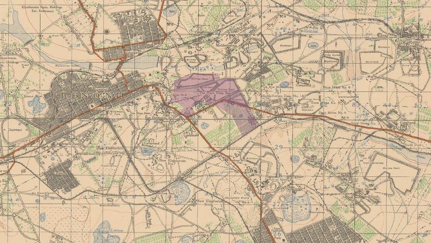
2018/03/14

                                 CREDIT SHEET
Project Director
STEPHAN GAIGHER (BA Hons, Archaeology, UP)
Principal Investigator for G&A Heritage
Member of ASAPA (Site Director Status)
Tel: (015) 516 1561
Cell: 073 752 6583
E-mail: stephan@gaheritage.co.za
Website: www.gaheritage.co.za

Report Author
STEPHAN GAIGHER

 Disclaimer; Although all possible care is taken to identify all sites of cultural importance during the investigation of
   study areas, it is always possible that hidden or sub-surface sites could be overlooked during the study. G&A
    Heritage and its personnel will not be held liable for such oversights or for costs incurred as a result of such
                                                      oversights.

Statement of Independence
As the duly appointed representative of G&A Heritage, I Stephan Gaigher, hereby confirm my
independence as a specialist and declare that neither I nor G&A Heritage have any interests, be it
business or otherwise, in any proposed activity, application or appeal in respect of which the
Environmental Consultant was appointed as Environmental Assessment Practitioner, other than fair
remuneration for work performed on this project.

                             SIGNED OFF BY: STEPHAN GAIGHER

                             ……………………………………………….

HIA: Mackenzie Park Ext. 3                                  ii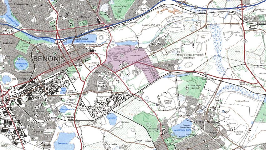
2018/03/14
MANAGEMENT SUMMARY
Site name and location: Proposed Residential Township, Mackenzie Park Extension 3, Situated on Parts of
Remaining Extent of Farm Benoni 77- IR.
Municipal Area: Ekurhuleni Metropolitan Municipality, Gauteng Province.
Developer: Shuma Africa Projects (Pty) Ltd.
Consultant: G&A Heritage, PO Box 522, Louis Trichardt, 0920, South Africa.
38A Vorster St, Louis Trichardt, 0920
Date of Report: 14 March 2018
The purpose of the management summary is to distil the information contained in the report into a format
that can be used to give specific results quickly and facilitate management decisions. It is not the purpose
of the management summary to repeat in shortened format all the information contained in the report, but
rather to give a statement of results for decision making purposes.
This study focuses on the Heritage Impact Assessment for the Proposed Residential Township,
Mackenzie Park Extension 3, Situated on Parts of Remaining Extent of Farm Benoni 77-IR in the
Ekurhuleni Metropolitan Municipality, Gauteng Province.
This study encompasses the heritage impact investigation. A preliminary layout has been supplied to lead
this phase of this study.
Scope of Work
A Heritage Impact Assessment (including Archaeological, Cultural heritage, Built Heritage and Basic
Paleontological Assessment) to determine the impacts on heritage resources within the study area.
The following are the required to perform the assessment:
A desk-top investigation of the area;
A site visit to the proposed development site;
Public participation with Interested and Affected Parties (IAP’s)
Identify possible archaeological, cultural, historic, built and paleontological sites within the
proposed development area;
Evaluate the potential impacts of construction and operation of the proposed development on
archaeological, cultural, historical resources; built and paleontological resources; and
Recommend mitigation measures to ameliorate any negative impacts on areas of archaeological,
cultural, historical, built and paleontological importance.
The purpose of this study is to determine the possible occurrence of sites with cultural heritage
significance within the study area. The study is based on archival and document combined with fieldwork
investigations.
Findings & Recommendations
The area was investigated during a field visit and through archival studies. It is not anticipated that the
development will be bedrock intrusive and as such a paleontological deposits will not be affected.
An old mine shaft and the overburden dump with associated infrastructure were observed within the study
area. Due to the importance of mining in the evolution of the East Rand urban landscape these structures
have significant historic value. For this reason, it is important that the site undergoes a second phase of
investigation to determine its architectural and historic significance before any structures are demolished.
It is recommended that obscured, subterranean sites be managed, if they are encountered.
HIA: Mackenzie Park Ext. 3 iii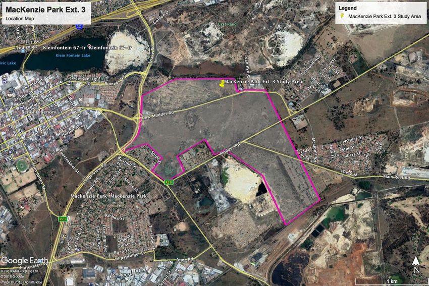
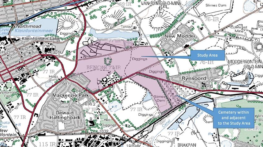
2018/03/14

The Rynsoord Cemetery is situated in the southeastern corner of the site, between Main Reef Road and
the Railway Line. This proximity should be taken into consideration.

Fatal Flaws
No fatal flaws were recorded.

HIA: Mackenzie Park Ext. 3                      iv
2018/03/14

                           TABLE OF CONTENTS

1. Introduction ................................................................................................. 11

2. Background Information ........................................................................... 14

2.1 Project Description and Location ............................................................... 14

2.2 Design Concept .......................................................................................... 16

2.3 GPS Track................................................................................................... 17

3. Regional Cultural Context ........................................................................ 18

3.1 Paleontology ............................................................................................... 18

3.2 Prehistory .................................................................................................... 18

3.3 Stone Age.................................................................................................... 19

3.4 Iron Age ....................................................................................................... 20

3.5 The Historic Era .......................................................................................... 21

3.6 Cultural Landscape ..................................................................................... 23

3.7 Previous Studies ......................................................................................... 32

3.8 Historical Maps............................................................................................ 34

4. Findings ....................................................................................................... 37

4.1 Fieldwork Results........................................................................................ 37

Mining Structures .............................................................................................. 37

Benoni / Rynsoord Cemetery ........................................................................... 37

5. Methodology ............................................................................................... 38

5.1 Inventory...................................................................................................... 38

5.2 Evaluating Heritage Impacts ...................................................................... 38

5.3 Fieldwork ..................................................................................................... 39

5.4 Public Participation ..................................................................................... 39

6. Measuring Impacts..................................................................................... 39

6.1 Type of Resource ....................................................................................... 39

HIA: Mackenzie Park Ext. 3                                                          v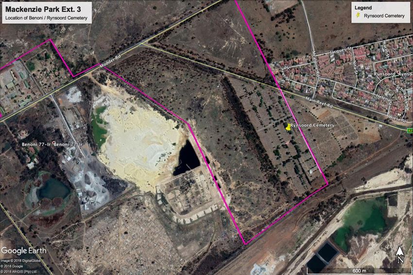
2018/03/14

6.2 Type of Significance ................................................................................... 39

6.2.1 Historic Value ........................................................................................... 39

6.2.2 Aesthetic Value ........................................................................................ 40

6.2.3 Scientific Value......................................................................................... 40

6.2.4 Social Value / Public Significance ........................................................... 41

6.2.5 Ethnic Significance .................................................................................. 41

6.2.6 Economic Significance ............................................................................ 41

6.2.7 Scientific Significance .............................................................................. 41

6.2.8 Historic Significance ................................................................................ 42

6.2.9 Public Significance................................................................................... 42

6.2.10 Other....................................................................................................... 42

6.3 Degrees of Significance.............................................................................. 42

6.3.1 Significance Criteria ................................................................................. 42

6.3.2 Rarity ........................................................................................................ 43

6.3.3 Representivity .......................................................................................... 43

7. Assessment of Heritage Potential ........................................................... 43

7.1 Assessment Matrix ..................................................................................... 43

7.1.1 Determining Archaeological Significance ............................................... 43

7.2 Assessing site value by attribute ................................................................ 45

7.3 Impact Statement........................................................................................ 45

7.3.1 Assessment of Impacts ........................................................................... 45

7.4 Indicators of Impact Severity ...................................................................... 46

7.5 Paleontological sites ................................................................................... 46

7.6 Post-Contact Sites ...................................................................................... 47

7.7 Built Environment ........................................................................................ 47

7.8 Historic Significance.................................................................................... 48

7.9 Architectural Significance ........................................................................... 48

7.10 Spatial Significance .................................................................................. 48

8. Impact Evaluation....................................................................................... 49

HIA: Mackenzie Park Ext. 3                                                          vi
2018/03/14

8.1 Determination of Significance of Impacts .................................................. 49

8.2 Impact Rating System ................................................................................ 49

8.2.1 Rating System Used to Classify Impacts ............................................... 49

9. Anticipated Impact of the Development ................................................. 53

9.1 Obscured or Buried Heritage sites of significance Including Palaeontology53

9.2 Rynsoord Cemetery.................................................................................... 53

9.2 Assessing Visual Impact ............................................................................ 54

9.3 Assumptions and Restrictions .................................................................... 54

9.3.1 Cultural Landscape.................................................................................. 55

9.4 Mitigation ..................................................................................................... 56

10. Resource Management Recommendations and Chance Finds Protocol                                                         56

11. Conclusion ................................................................................................ 57

12. References Cited ...................................................................................... 57

HIA: Mackenzie Park Ext. 3                                                         vii
2018/03/14
List of Figures
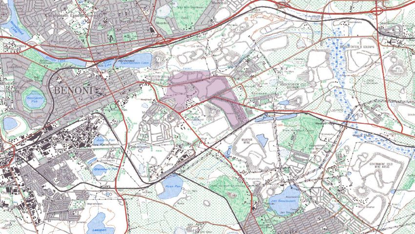
Figure 1. Location Map of the Study Area ....................................................... 15
Figure 2. Google Earth Image of the Study Area ............................................ 15
Figure 3. Design concept.................................................................................. 16
Figure 4. GPS Track Path ................................................................................ 17
Figure 5. PalaeoSensitivity Map....................................................................... 18
Figure 7. (1) handaxe on flake; (2) thick discoidal core; (3) polyhedral core (Pollarolo, Kuman, Bruxelles, 2010)
........................................................................................................................... 19
Figure 8. (1,2) Handaxes with large side removal; (3-6) handaxes (Pollarolo, Susino, Kuman, Bruxelles, 2010)
........................................................................................................................... 20
Figure 9. Earliest known photograph of Benoni (1900 - 1910). Published in East Rand Annual in 1936 22
Figure 10. Logistics Company C/O Snake Road and New Modder Road .... 24
Figure 11. Racetrack......................................................................................... 24
Figure 12. Benoni / Rynsoord Cemetery ......................................................... 25
Figure 13. Benoni / Rynsoord Cemetery ......................................................... 25
Figure 14. Location of the Benoni / Rynsoord Cemetery................................ 26
Figure 15. Location of the Benoni / Rynsoord Cemetery................................ 26
Figure 16. View towards the south from New Modder Road.......................... 27
Figure 17. View towards the south from New Modder Road.......................... 28
Figure 18. Building Rubble within the Study Area ........................................... 28
Figure 19. Study Area along New Modder Road ............................................ 29
Figure 20. Paved road within the Study Area .................................................. 29
Figure 21. View of the derelict mining land on the site's northern boundary . 30
Figure 22. View of the derelict mining land on the site's northern boundary . 30
Figure 23. View of the derelict mining land on the site's northern boundary . 31
Figure 24. View of the derelict mining land on the site's northern boundary . 31
Figure 25. Study Area along Modder Road..................................................... 32
Figure 26. Fairly recent derelict building within the Study Area...................... 32
HIA: Mackenzie Park Ext. 3 viii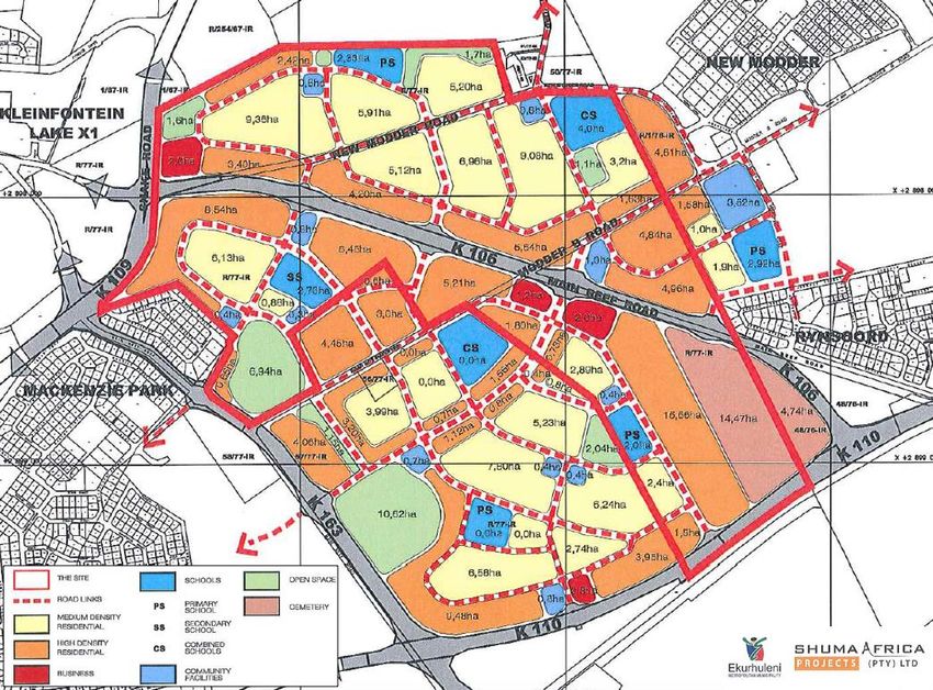
2018/03/14

Figure 27. Topographical Map 2628 AB 1939 ................................................ 34

Figure 28. Topographical Map 2628 AB 1957 ................................................ 34

Figure 29. Topographical Map 2628 AB 1976 ................................................ 35

Figure 30. Topographical Map 2628 AB 1983 ................................................ 35

Figure 31. Topographical Map 2628 AB 1995 ................................................ 36

Figure 32. Topographical Map 2628 AB 2002 ................................................ 36

Figure 33. Topographical Map 2628 AB 2010 ................................................ 37

Figure 34. Palaeontology Sensitivity Map ....................................................... 47

HIA: Mackenzie Park Ext. 3                                            ix
2018/03/14

                              List of Abbreviations
Bp.................................................................................................. Before Present
DoT ............................................................................... Department of Transport
EIA ................................................................................................. Early Iron Age
ESA............................................................................................. Early Stone Age
                                                                                                                -15
Fm ....................................................................................... Femtometre (10 m)
GPS .................................................................. Geographic Positioning System
HIA .........................................................................Heritage Impact Assessment
LIA................................................................................................... Late Iron Age
LSA .............................................................................................. Late Stone Age
MYA ..........................................................................................Million Years Ago
MSA ......................................................................................... Middle Stone Age
NHRA ..................................... National Heritage Resources Act no 22 of 1999
SAHRA ............................................. South African Heritage Resource Agency
S&EIR ............................................Scoping & Environmental Impact Reporting
                                                                                                                -6
Um ........................................................................................ Micrometre (10 m)
WGS 84 .......................................................... World Geodetic System for 1984

HIA: Mackenzie Park Ext. 3                                                        x
Chapter
1 Project Resources
Heritage Impact Report
Heritage Impact Assessment Report for the Proposed
Residential Township, Mackenzie Park Extension 3, situated on
parts of the Remaining Extent of the Farm Benoni 77 - I.R. in
the Ekurhuleni Metropolitan Municipality, Gauteng Province.
1. Introduction
Legislation and methodology
G&A Heritage was appointed by Metroprojects to undertake a heritage impact assessment for the
Proposed Residential Township, Mackenzie Park Extension 3, situated on Parts of the Remaining Extent
of the Farm Benoni 77-IR in the Ekurhuleni Metropolitan Municipality, Gauteng Province.
Section 38(1) of the South African Heritage Resources Act (25 of 1999) requires that a heritage study is
undertaken for:
(a) Construction of a road, wall, power line, pipeline, canal or other similar form of linear
development or barrier exceeding 300 m in length;
(b) Construction of a bridge or similar structure exceeding 50 m in length; and
(c) Any development, or other activity which will change the character of an area of land, or water –
2
(1) Exceeding 10 000 m in extent;
(2) Involving three or more existing erven or subdivisions thereof; or
(3) Involving three or more erven, or subdivisions thereof, which have been consolidated within the past
five years; or
(d) The costs of which will exceed a sum set in terms of regulations; or
(e) Any other category of development provided for in regulations.
While the above describes the parameters of developments that fall under this Act., Section 38 (8) of the
NHRA is applicable to this development. This section states that;
(8) The provisions of this section do not apply to a development as described in subsection
(1) if an evaluation of the impact of such development on heritage resources is required
in terms of the Environment Conservation Act, 1989 (Act 73 of 1989), or the integrated
environmental management guidelines issued by the Department of Environment Affairs
and Tourism, or the Minerals Act, 1991 (Act 50 of 1991), or any other legislation:
Provided that the consenting authority must ensure that the evaluation fulfils the
requirements of the relevant heritage resources authority in terms of subsection (3), and
any comments and recommendations of the relevant heritage resources authority with
regard to such development have been taken into account prior to the granting of the
consent.
In regards to a development such as this that falls under Section 38 (8) of the NHRA, the requirements of
Section 38 (3) applies to the subsequent reporting, stating that;
(3) The responsible heritage resources authority must specify the information to be provided in a
report required in terms of subsection (2) (a): Provided that the following must be included:
(a) The identification and mapping of all heritage resources in the area affected;
11
HIA: Mackenzie Park Ext. 32018/03/14
(b) An assessment of the significance of such resources in terms of the heritage
assessment criteria set out in section 6 (2) or prescribed under section 7;
(c) An assessment of the impact of the development on such heritage resources;
(d) An evaluation of the impact of the development on heritage resources relative to the
sustainable social and economic benefits to be derived from the development;
(e) The results of consultation with communities affected by the proposed development
and other interested parties regarding the impact of the development on heritage
resources;
(f) If heritage resources will be adversely affected by the proposed development, the
consideration of alternatives; and
(g) Plans for mitigation of any adverse effects during and after the completion of the
proposed development.
(1) Ancestral graves,
(2) Royal graves and graves of traditional leaders,
(3) Graves of victims of conflict (iv) graves of important individuals,
(4) Historical graves and cemeteries older than 60 years, and
(5) Other human remains which are not covered under the Human Tissues Act, 1983 (Act
No.65 of 1983 as amended);
(h) Movable objects, including ;
(1) Objects recovered from the soil or waters of South Africa including archaeological and
paleontological objects and material, meteorites and rare geological specimens;
(2) Ethnographic art and objects;
(3) Military objects;
(4) Objects of decorative art;
(5) Objects of fine art;
(6) Objects of scientific or technological interest;
(7) Books, records, documents, photographic positives and negatives, graphic, film or
video material or sound recordings; and
(8) Any other prescribed categories, but excluding any object made by a living person;
(i) Battlefields;
(j) Traditional building techniques.
A ‘place’ is defined as:
(a) A site, area or region;
(b) A building or other structure (which may include equipment, furniture, fittings and articles associated
with or connected with such building or other structure);
(c) A group of buildings or other structures (which may include equipment, furniture, fittings and articles
associated with or connected with such group of buildings or other structures); and (d) an open space,
including a public square, street or park; and in relation to the management of a place, includes the
immediate surroundings of a place.
‘Structures’ means any building, works, device, or other facility made by people and which is fixed to
land and any fixtures, fittings and equipment associated therewith older than 60 years.
‘Archaeological’ means:
(a) Material remains resulting from human activity which are in a state of disuse and are in or on land and
are older than 100 years, including artefacts, human and hominid remains and artificial features and
structures;
(b) Rock art, being a form of painting, engraving or other graphic representation on a fixed rock surface or
loose rock or stone, which was executed by human agency and is older than 100 years including any
area within 10 m of such representation; and
(c) Wrecks, being any vessel or aircraft, or any part thereof, which was wrecked in South Africa, whether
on land or in the maritime cultural zone referred to in section 5 of the Maritime Zones Act 1994 (Act 15 of
1994), and any cargo, debris or artefacts found or associated therewith, which are older than 60 years or
which in terms of national legislation are considered to be worthy of conservation;
(d) Features, structures and artefacts associated with military history which are older than 75 years and
the sites on which they are found.
HIA: Mackenzie Park Ext. 3 122018/03/14
‘Paleontological’ means any fossilised remains or fossil trace of animals or plants which lived in the
geological past, other than fossil fuels or fossiliferous rock intended for industrial use, and any site which
contains such fossilised remains or trace.
‘Grave’ means a place of interment and includes the contents, headstone or other marker of and any
other structures on or associated with such place. The South African Heritage Resources Agency
(SAHRA) will only issue a permit for the alteration of a grave if it is satisfied that every reasonable effort
has been made to contact and obtain permission from the families concerned.
The removal of graves is subject to the following procedures as outlined by the SAHRA:
- Notification of the impending removals (using English, Afrikaans and local language media and
notices at the grave site);
- Consultation with individuals or communities related or known to the deceased;
- Satisfactory arrangements for the curation of human remains and / or headstones in a museum,
where applicable;
- Procurement of a permit from the SAHRA;
- Appropriate arrangements for the exhumation (preferably by a suitably trained archaeologist) and
re-interment (sometimes by a registered undertaker, in a formally proclaimed cemetery);
- Observation of rituals or ceremonies required by the families.
The limitations and assumptions associated with this heritage impact assessment are as follows;
- Field investigations were performed on foot and by vehicle where access was readily available.
- Sites were evaluated by means of description of the cultural landscape, direct observations and
analysis of written sources and available databases.
- It was assumed that the site layout as provided by Metroprojects is accurate.
- We assumed that the public participation process performed as part of the Basic Assessment
process was sufficiently encompassing not to be repeated in the Heritage Assessment Phase.
Table 1. Impacts on the NHRA Sections
Act Section Description Possible Impact Action
National Heritage 34 Preservation of buildings No N/A
Resources Act older than 60 years
(NHRA) 35 Archaeological, No N/A
paleontological and
meteor sites
36 Graves and burial sites No N/A
37 Protection of public No N/A
monuments
38 Does activity trigger a Yes HIA
HIA?
Table 2. NHRA Triggers
Action Trigger Yes/No Description
Construction of a road, wall, power line, pipeline, canal or No N/A
other linear form of development or barrier exceeding
300m in length.
Construction of a bridge or similar structure exceeding No N/A
50m in length.
2
Development exceeding 5000 m Yes Mackenzie Park Ext. 3 (225,06
ha)
Development involving more than 3 erven or sub No N/A
divisions
Development involving more than 3 erven or sub No N/A
divisions that have been consolidated in the past 5 years
HIA: Mackenzie Park Ext. 3 132018/03/14
2
Re-zoning of site exceeding 10 000 m No N/A
Any other development category, public open space, No N/A
squares, parks or recreational grounds
2. Background Information
2.1 Project Description and Location
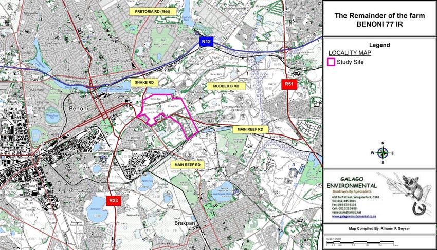
An application is made for the establishment of a residential township, to be known as Mackenzie Park
Extension 3, on parts of the Remaining Extent of the Farm Benoni 77-IR, in the Ekurhuleni Metropolitan
Municipality, Gauteng Province.
The Farm Benoni 77-IR belongs to Government and is situated east of the Benoni CBD in the East Rand
Mining Belt. This land was in the past used for mining purposes, but substantial parts of it have, during
the past two decades, been rehabilitated and now lie vacant. One such parcel, east of Snake Road up to
New Modder and Rynsoord Townships, seems to be ideally suited for infill development, in line with
Ekurhuleni’s stated intent to prioritize vacant land in the Mining Belt for development.
In view of the above, Ekurhuleni Metropolitan Municipality’s Department of Human Settlement identified
the site for an integrated residential development project which will cater for people across the socio-
economic spectrum and which will contribute to alleviating the current housing backlog in Ekurhuleni.
The site is situated in the eastern part of Ekurhuleni, in the Benoni Customer Care Area, only
approximately 1km south of the N12 / Snake Road intersection and approximately 1,5km east of Benoni
CBD. It is close to major employment areas such as the Benoni South and Apex industrial townships and
to the higher-order urban amenities which can be found in the Benoni and Brakpan CBD’s, while it also
abuts a number of established suburbs, such as Mackenzie Park, New Modder and Rynsoord.
The site is very accessible – The R23 abuts it on the west, providing access to the N12 to the north and
to the N17 and the N3 to the south, while a number of local arterial routes (New Modder Road, Modder B
Road and Main Reef Road) run through it, linking it to surrounding centres.
The property is registered under the Certificate of Registered Crown Title T8731/1937.
There are a number of (mostly illegible) endorsements on the Deed, relating mainly to land transfers out
of the Remainder, but also to some servitudes in favour of the local authority, Eskom and Rand Water.
Most of the conditions in the Title Deed will be notarially removed when the Township Register is opened.
Existing servitudes over the site are accommodated in the Layout Plan.
HIA: Mackenzie Park Ext. 3 142018/03/14
Figure 1. Location Map of the Study Area
Figure 2. Google Earth Image of the Study Area
HIA: Mackenzie Park Ext. 3 152018/03/14
2.2 Design Concept
Figure 3. Design concept
From the image above, it is evident that even though the Benoni / Rynsoord Cemetery falls within the
study area, it will still be zoned as such.
HIA: Mackenzie Park Ext. 3 162018/03/14
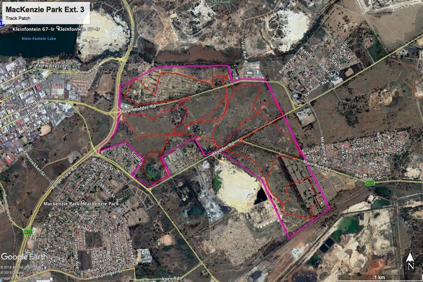
2.3 GPS Track
Figure 4. GPS Track Path
Chapter
Findings
HIA: Mackenzie Park Ext. 3 172018/03/14
2
Heritage Indicators within the receiving
Environment
3. Regional Cultural Context
3.1 Paleontology
The palaeontology of Western Gauteng is well researched in areas. The discovery of the Sterkfontein
skeletons put this area in the forefront of palaeontology worldwide. The rule of “absence of evidence is
not evidence of absence” should be applied to this area. Taken the rich palaeontology of Western
Gauteng it is conceivable that similar finds could be made in this area.
The study area falls within the red, green and blue designations indicating that a Palaeontological Impact
Field Assessment should be conducted and protocols be put in place for any findings.
Figure 5. PalaeoSensitivity Map
3.2 Prehistory
In 1929, archaeologists working in South Africa devised a system of dividing the Stone Age into 3
periods, namely the Early Stone Age, the Middle Stone Age and the Later Stone Age.
HIA: Mackenzie Park Ext. 3 182018/03/14
3.3 Stone Age
No substantial number of Stone Age sites from any period of the Stone Age is known to exist in this area
– primarily as a result of a lack of research and general ignorance amongst the layman in recognizing
stone tools that often may occur. However, it is possible that the first humans in the Benoni area may
have been preceded by Homo erectus, who roamed large parts of the world during the Aucheulian period
of the Early Stone Age, 500 000 years ago. The predecessors of Homo erectus, Australopithecus, which
is considered to be the earliest ancestor of modern humans, lived in the Blaauwbank Valley around
Krugersdorp (today part of the Cradle of Humankind – a World Heritage Site) several million years ago.
During the Middle Stone Age, 200 000 years ago, modern man or Homo sapiens emerged,
manufacturing a wider range of tools, with technologies more advanced than those from earlier periods.
This enabled skilled hunter-gatherer bands to adapt to different environments. From this time onwards,
rock shelters and caves were used for occupation and reoccupation over very long periods of time
(Mitchell 2002). Two Middle Stone Age sites at the Withoek Spruit (Brakpan) were researched 17 years
ago, but no information on this discovery has been published.
Figure 6. (1) handaxe on flake; (2) thick discoidal core; (3) polyhedral core (Pollarolo, Kuman, Bruxelles, 2010)
HIA: Mackenzie Park Ext. 3 192018/03/14
Figure 7. (1,2) Handaxes with large side removal; (3-6) handaxes (Pollarolo, Susino, Kuman, Bruxelles, 2010)
The Late Stone Age, considered to have started some 20 000 years ago, is associated with the
predecessors of the San and Khoi Khoi. San hunter-gatherer bands with their small (microlithic) stone
tools may have lived in Eastern Gauteng, as a magnificent engraving site near Duncanville attests to their
presence in Vereeniging, south of, but close to Ekurhuleni. Stone Age hunter-gatherers lived well into the
19th century in some places in SA, but may not have been present in Brakpan when the first European
colonists crossed the Vaal River during the early part of the 19th century Stone Age sites may occur all
over the area where an unknown number may have been obliterated by mining activities, urbanization,
industrialization, agriculture and other development activities during the past decades (Morris 2004).
Reverent Patterson discovered some Stone Age deposits in Benoni during 1933, close to the train
station. These were probably from the Middle to Late Stone Age.
3.4 Iron Age
th
A considerable number of Late Iron Age, stone walled sites, dating from the 18th and the 19 centuries
(some of which may have been occupied as early as the 16th century), occur along and on top of the
rocky ridges of the eastern part of the Klipriviersberg towards Alberton. These settlements and features in
these sites, such as huts, were built with dry stone, reed and clay available from the mountain and the
Klip River (Mason 1968, 1986).
The Late Iron Age sites within Ekurhuleni’s south-eastern border are a ‘spill-over’ from a larger
concentration which are located further towards the west, in the Witwatersrand, while large
concentrations of stone walled sites are also located directly to the south of Johannesburg, in the
mountainous area around the Suikerbosrand in Heidelberg. The stone walled settlements are
concentrated in clusters of sites and sometimes are dispersed over large areas making them vulnerable
to developments of various kinds. A site consists of a circular or elliptical outer wall that is composed of a
HIA: Mackenzie Park Ext. 3 202018/03/14 number of scalloped walls facing inwards towards one or more enclosures. Whilst the outer scalloped walls served as dwelling quarters for various family groups, cattle, sheep and goat were stocked in the centrally located enclosures. Huts with clay walls and floors were built inside the dwelling units. Pottery and metal items are common on the sites. However, iron and copper were not produced locally on these sites (Killick 2004). Some 100 years earlier, African farmers in the Fokeng cluster built stonewalled settlements in the Tshwane area that emphasised the centre/side axis. From the air, these earlier settlements resemble a 'fried egg'; that is, a smooth outer ring about 60 metres across enclosed in a central cattle byre about 20 metres in diameter. This type has its origins among BaFokeng living near the hill Ntsuanatsatsi in the Free State (see pre history of Bloemfontein). When these early BaFokeng people moved north across the Vaal River, they met the ancestors of Southwest Sotho-Tswana, such as BaRolong and BaThlaping. Their interaction helped to create a new type of stonewalling called Klipriviersburg. Besides Johannesburg, Klipriviersburg walling is also found around Pretoria. All of these people were mixed farmers; that is, they herded cattle as well as sheep and goats, and they cultivated sorghums, millets and various beans and peas. They were also capable of making metal tools and jewellery. The earliest evidence of metal working in the region comes from the site Broederstroom west of Pretoria. Archaeologists have uncovered the remains of at least two stratified villages there that date back to between AD 550 and 700, each with evidence of iron forging. Two major technological steps characterise ancient iron production: smelting and forging. Technically, iron ore is reduced in a furnace to create a bloom. During this smelting process, silica in the host rock melts, flowing off as slag leaving the bloom behind. The bloom has to be forged in an oxidised atmosphere, usually in an open hearth. In both smelting and forging, bellows attached to clay pipes help the operators reach the necessary high temperatures. Culturally, Bantu-speaking people in the recent past compared the smelting process to childbirth, a private and sacred affair. Consequently, the smelter was usually secluded outside the settlement. Forging, in contrast, was comparable to raising the child; and so the forge was located in a public area in the centre of the homestead. The forges at Broederstroom follow this pattern. (http://www.sahistory.org.za/topic/prehistory-pretoria) 3.5 The Historic Era The first inhabitants of this area were Stone Age hunter-gatherers who roamed here some 50 000 years ago. Remnants of their weapons were found in the Rynfield area and near Cranbourne Station many years ago. The first Voortrekker parties crossed the Vaal River and started occupying the area in the 1830’s. Farmers started moving into the area and declared farms for themselves, especially after the singing of the Sand River convention in 1852. Benoni’s inauspicious beginnings were in 1881 when then surveyor general, Johan Rissik, found it difficult to assign title deeds to all unclaimed state property. He named the area ‘Benoni (Son of my Sorrows)’ after the name given by Rachel to her son in the biblical book of Genesis. “Brakpan” was named in 1886, due to the very brackish water from a small pan on the Farm “Weltevreden”. The evolution of the region Southern Transvaal, its industrial development, rate of urban development and settlement pattern were greatly influenced by geology and mining, following the discovery of gold deposits in 1886 and coal in 1888. A gold mine in the Witwatersrand Reef on Rietfontein farm that started up in 1893. Sir George Farrar, the chairman of a mining company, undertook the planning of the rapidly growing mining town of Benoni in 1904. A river was dammed to create a series of reservoirs for mine use. Benoni was declared a township in 1906. HIA: Mackenzie Park Ext. 3 21
2018/03/14

                     Figure 8. Earliest known photograph of Benoni (1900 - 1910). Published in East Rand Annual in 1936

The Brakpan Mines Company sunk its first two gold mine shafts in 1905. Brakpan remained a suburb of
Benoni until 1919 when it was granted the status of a municipality and proclaimed as a town.

The Rand Rebellion (or Rand Revolt) was an armed uprising of white miners in the Area in March 1922.
Following a drop in gold prices, the companies tried to cut their costs by reducing wages and promoting
more African miners to skilled and supervisory positions at lowers rates.

The strike started on 28 December 1921 and became an open rebellion against the state. The workers
armed themselves and took over Brakpan, Benoni and some suburbs of Johannesburg. The strike
continued for three months, involving bloody clashes between the miners and the military workers. On 9
March, Prime Minister Smuts issued mobilization orders for the Active Citizens Force and declared
martial law. The rebellion was crushed by considerable military power (20 000 troops, artillery, tanks and
bomber aircraft) and as the cost of over 200 lives.

During the Apartheid Era (1948 to 1994), it was the discriminatory racial segregation (apartheid)
legislation, enacted by the Nationalist Party (after coming to power in 1948) that extensively transformed
the land-use. Citizens were separated into different townships according to their race with buffer strips of
at least 100m wide or by environmental buffer zones thus the Black South Africans in the area lived in the
Brakpan Old Location.

During the Apartheid Era, designated townships for Blacks were established outside Benoni,
namely Daveyton and Wattville. The township of Actonville was established for the habitation of
Indians, whilst ‘Benoni Proper’ was reserved for ‘whites only’. These various suburbs remain,
although the City is today relatively well integrated and all race groups may live wh ere they
choose. Each of these suburbs have their own interesting histories.

The Brakpan Old Location was the backdrop to many anti-apartheid struggles. The people living in the
location were actively trying to improve their living conditions and to challenge the laws that were
suffocating them.
Mbulelo Vizikhungo Mzamane wrote “Children of Paradise” to detail the area and the events of the time,
through his own eyes as a young boy living in Brakpan Old Location. It is a poignant story of the
innocence and trust of a young, black South African, who does not understand the severity of the
situation he is caught in. Although beautifully told, it does not provide specific historical references to
events unfolding in the area. It does however mention events and places that can be researched through
alternative methods.

Vosloorus was established in 1963 when Black Africans were removed from Stirtonville because it was
considered by the government too close to a white town. Stirtonville, renamed Reiger Park, has since

HIA: Mackenzie Park Ext. 3                                   22
2018/03/14 become home to Boksburg's coloured community. A local authority was established in 1983 when Vosloorus was given full municipal status. It has been said that Former Pres. Nelson Mandela was hiding out in the Stirtonville area and surrounds. The community of Brakpan Old Location were forcibly removed from their homes from 1974 to 1978 and had to re-establish themselves in Tskane approximately 15km South. The Old Location was razed. In 1988, the town councils of Vosloorus and Reiger Park staged a consumer boycott in Boksburg on the East Rand. The boycott by black and coloured residents followed the reintroduction of petty apartheid measures of the Boksburg Town Council, which at the time was controlled by the Conservative Party (CP). The boycott found enthusiastic corporate support. A number of multinational companies like Colgate- Palmolive, American Cyanamid and Unilever provided buses to ferry shoppers to shops in neighbouring towns, cancelled expansion plans and ran advertisements denouncing the racist Council. The economy of the town suffered and several businesses had to close down. Since 1978, the recycling of the mine tailings at Brakpan (the largest such dump in the Witwatersrand) has resulted in the recovery of significant residual quantities of gold and uranium. The Benoni and Brakpan Municipalities were incorporated into the Ekurhuleni metropolitan Municipality in 2001. Over time gold mining in the area has decreased in importance. Today Benoni is focused more on industry and services, rather than mining, and is used as a service hub for other East Rand towns such as Brakpan, Nigel and Springs. Benoni is also the site of the Benoni Heliport, for the use of helicopters. Sources: http://global.britannica.com/EBchecked/topic/77462/Brakpan http://www.sacp.org.za/docs/history/fifty3.html http://www.historyworld.net/wrldhis/PlainTextHistories.asp?ParagraphID=otw http://cals.ukzn.ac.za/Libraries/General_Docs/Mbulelo_Mzamane.sflb.ashx http://www.sahistory.org.za/people/david-wilcox-bopape http://www.liferattle.ca/radio/podcast20110213.html Global.Britannica.com/Brakpan Historyworld.net SA History Online/Boksburg SA History Online/Consumer Boycotts Boksburg Historical.com SA Military History.org Mbulelo Vizikhungo Mzamane, “Children of Paradise” 3.6 Cultural Landscape 3.6.1 Existing land use Three tarred roads traverse the site, namely New Modder Road, Modder B Road and Main Reef Road. As stated previously, the site is mostly vacant, having previously been used for slimes dams which have since been removed. Old slimes paddocks are situated on the northern part of the site, between New Modder Road and the Kleinfontein wetland. A radiation study was conducted over the entire site. The conclusion of the survey is that no reading above 0.5Bq (Bequerel) per gram was encountered on the site and that it is therefore safe for human habitation. There are two old mine shafts on the northern part of the site, between New Modder and Modder B Roads. Buffer zones will be created around them and they will be capped to the satisfaction of DMR. HIA: Mackenzie Park Ext. 3 23
2018/03/14

Department of Transport Roads Depot and nineteen houses abuts New Modder Road on the north and
have been excluded from the proposed township area.

A logistics company (“On the Dot”) is situated on the site in the northwestern quadrant of the Snake Road
/ New Modder intersection.

                     Figure 9. Logistics Company C/O Snake Road and New Modder Road

The “Speedworld Dirt Park” Racetrack is located in the northeastern quadrant of the site on New Modder
Road.

                     Figure 10. Racetrack

HIA: Mackenzie Park Ext. 3                                24
2018/03/14
The Rynsoord Cemetery is situated in the southeastern corner of the site, between Main Reef Road and
the Railway Line.
Figure 11. Benoni / Rynsoord Cemetery
Figure 12. Benoni / Rynsoord Cemetery
HIA: Mackenzie Park Ext. 3 252018/03/14
Figure 13. Location of the Benoni / Rynsoord Cemetery
Figure 14. Location of the Benoni / Rynsoord Cemetery
HIA: Mackenzie Park Ext. 3 262018/03/14
3.6.2 Surrounding land uses include the following:
The site is surrounded by vacant, derelict old mining land and fragmented urban development on all
sides.
The Kleinfontein wetland abuts the site’s northern boundary, with old derelict land and slimes dams north
of the spruit and a narrow strip of industrial development to the north of that adjacent to the N12 freeway.
New Modder residential township abuts the site on the northeast, with Rynsoord residential township
further towards the south. Large tracts of vacant derelict old mining land are situated around these
townships.
Land uses abutting the south and southwest of the site include the Brakpan Raceway, vacant derelict old
mining land and a sand dump which is being rehabilitated, an asphalt manufacturing plant and various
government-related land uses, including the SAPS dog unit, a depot and housing of the Gauteng
Department of Transport. A substantial informal settlement is situated in this area.
Apex industrial township is situated further towards the southwest, west Main Reef Road.
The northwest of the site abuts Mackenzie Park and vacant land.
Figure 15. View towards the south from New Modder Road
HIA: Mackenzie Park Ext. 3 272018/03/14
Figure 16. View towards the south from New Modder Road
Figure 17. Building Rubble within the Study Area
HIA: Mackenzie Park Ext. 3 282018/03/14
Figure 18. Study Area along New Modder Road
Figure 19. Paved road within the Study Area
HIA: Mackenzie Park Ext. 3 292018/03/14
Figure 20. View of the derelict mining land on the site's northern boundary
Figure 21. View of the derelict mining land on the site's northern boundary
HIA: Mackenzie Park Ext. 3 302018/03/14
Figure 22. View of the derelict mining land on the site's northern boundary
Figure 23. View of the derelict mining land on the site's northern boundary
HIA: Mackenzie Park Ext. 3 312018/03/14
Figure 24. Study Area along Modder Road
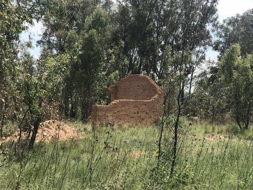
Figure 25. Fairly recent derelict building within the Study Area
3.7 Previous Studies
An extensive research into the SAHRIS database resulted in the identification of the following heritage
related studies that have been performed over the last decade in the study area. Only studies within a
radius of 50km from the study area were considered.
Pistorius, J.C.C. 2006. A Phase I Heritage Impact Assessment (HIA) Study for a Proposed New
Residential Development on the Farm Modderfontein 76IR in Benoni in the Gauteng Province,
South Africa.
HIA: Mackenzie Park Ext. 3 322018/03/14
Van Schalkwyk, J. 2014. Cultural Heritage Impact Assessment for the Proposed Residential
Development, Portion 57, Benoni 77IR, Ekurhuleni, Gauteng Province.
Kusel, U. 2007. Cultural Heritage Resource Impact Assessment of the Farm Vlaklaagte 161
Tsakane Benoni Gauteng.
Van Schalkwyk, J. 2014. Cultural Heritage Impact Assessment for the proposed residential
development, Vlakfontein Portion 50, Benoni, Ekurhuleni, Gauteng Province.
Van der Walt, J. 2008 Cultural Heritage Impact Assessment: Portions 18, 65, 83 and 194 of the
Farm Rietfontein 115 JR, Portion 23 and Remaining Extent of Portion 22 of the Farm
Weltevreden 118 IR, Benoni, Gauteng Province.
Van Der Walt, J. 2014. Archaeological Impact Assessment for the proposed Brakpan Memorial
Park Development, Gauteng Province.
Van Der Walt, J. 2009. Archaeological Impact Assessment: Helderwyk Township development
on the reminder of Portion 62 of the Farm Witpoortjie 117IR, Brakpan, Ekurhuleni, Gauteng
Province.
Pelser, A. 2011. A Phase I Archaeological Impact Assessment for the rehabilitation of the
Boksburg Lake Downstream Wetland in Boksburg, Gauteng Province.
Van der Walt, J., Birkholtz, P. 2012, Phase 1 Heritage Impact Assessment for the Proposed
Development of the ERPM Line Village, Boksburg, Gauteng.
Birkholtz, P., Salomon, A. 2011. Phase 1 Heritage Impact Assessment: Proposed Development
of Farrar Park, Ext. 1 Boksburg, Ekurhuleni Metropolitan Municipality, Gauteng Province.
Birkholtz, P., Salomon, A. 2011. Phase 1 Heritage Impact Assessment: Proposed Development
of Reiger Park Ext. 16 Boksburg, Ekurhuleni Metropolitan Municipality, Gauteng Province.
Birkholtz, P., Salomon, A. 2011. Phase 1 Heritage Impact Assessment: Proposed Development
of Reiger Park Ext. 18 Boksburg, Ekurhuleni Metropolitan Municipality, Gauteng Province.
Van Schalkwyk, J., Terblanche, M. 2013. Cultural Heritage Impact Assessment for the Proposed
Development on Portions 397 and 399 of the Farm Driefontein 85IR, Boksburg, Gauteng
Province.
Birkholtz, P., Salomon, A. 2011. Phase 1 Heritage Impact Assessment: Proposed Development
of Farrar Park Ext. 2, Boksburg, Ekurhuleni Metropolitan Municipality, Gauteng Province.
Birkholtz, P. 2014. Heritage Impact Assessment for Proposed Township Development:
Vosloorus Ext 24, Vosloorus Ext 61 and Vosloorus Ext 63, Boksburg Local Municipality,
Ekurhuleni Metropolitan Municipality, Gauteng Province.
Birkholtz, P. 2011. Phase 1 Heritage Impact Assessment: Proposed Comet Ext 14 Development
Located on Portion 43 of the Farm Driefontein 85-IR, Boksburg, Ekurhuleni Metropolitan
Municipality, Gauteng Province.
Pelser, A. 2011. A Phase 1 Archaeological Impact Assessment for the Rehabilitation of the
Libradene Wetland in Boksburg, Gauteng Province.
Birkholtz, P., Salomon, A. 2011. Phase 1 Heritage Impact Assessment: Proposed Leeuwpoort
North Development located on the remainder of portion 51 and 52 as well as part of portion 22 of
the Farm Leeuwpoort 113 IR, Boksburg, Ekurhuleni Metropolitan Municipality, Gauteng Province.
Magoma, M., Salomon, A. 2013. Archaeological Investigation Study for the proposed Solar
Power farm on Portion 12 & 13 of Farm Villa Liza 675 IR Mapleton, Ekurhuleni Metropolitan
Municipality, Gauteng Province.
Van Schalkwyk, J. 2007. Heritage Survey report for the proposed development on portions 43
and 52 of the farm Vlakplaats in the Boksburg Magisterial District, Gauteng.
Prins, F., Zuma, M. 2010. Cultural Heritage Impact Assessment of the Boksburg Mining Belt
Development. (Comet Extention 8 HIA).
Gaigher, S. 2017. Heritage Impact Assessment for the Proposed Upgrade to Apex Bulk Outfall
Sewer Line Phase 1 and Phase 2 near Benoni, Ekurhuleni Metropolitan Municipality, Gauteng
Province.
Gaigher, S. 2017. Heritage Impact Assessment for the Proposed New Modder Ext 4 Residential
Development on Part of the Remainder of Portion 1 of the Farm Modderfontein 76 IR near
Benoni, Ekurhuleni Metropolitan Municipality, Gauteng Province.
HIA: Mackenzie Park Ext. 3 332018/03/14
3.8 Historical Maps
Figure 26. Topographical Map 2628 AB 1939
Figure 27. Topographical Map 2628 AB 1957
HIA: Mackenzie Park Ext. 3 342018/03/14
Figure 28. Topographical Map 2628 AB 1976
Figure 29. Topographical Map 2628 AB 1983
HIA: Mackenzie Park Ext. 3 352018/03/14
Figure 30. Topographical Map 2628 AB 1995
Figure 31. Topographical Map 2628 AB 2002
HIA: Mackenzie Park Ext. 3 362018/03/14
Figure 32. Topographical Map 2628 AB 2010
Topographical Maps 2628 AB
Mining activities and the Benoni / Rynsoord Cemetery are displayed on the all topographical maps – 1939
right up to the last available map dated 2010.
4. Findings
4.1 Fieldwork Results
th
The field work was conducted on the 6 of March 2018.
The area was accessed by vehicle and investigated on foot.
Mining Structures
The mining structures and remains are protected under the NHRA 25 of 1999 and due to their
contribution to the cultural landscape of the Benoni area it is vital that this be recorded before any
development is embarked on.
Benoni / Rynsoord Cemetery
This is a fairly large cemetery that is located within the proposed development area. It is recommended
that the site be fenced off from the rest of the development. Fencing should not prohibit access to the site
for the next-of-kin or other visitors to graves located here. If the above is not possible, it is recommended
that the graves be relocated to a local cemetery under municipal administration.
HIA: Mackenzie Park Ext. 3 372018/03/14
Chapter
3 Impact Assessment
5. Methodology
This study defines the heritage component of the EIA process being undertaken for the Proposed
Residential Township, Mackenzie Park Extension 3, Situated on Parts of the Remaining Extent of the
Farm Benoni 77- IR in the Ekurhuleni Metropolitan Municipality, Gauteng Province. It is described as a
first phase (HIA). This report attempts to evaluate both the accumulated heritage knowledge of the area
as well as information derived from direct physical observations.
5.1 Inventory
Inventory studies involve the in-field survey and recording of archaeological resources within a proposed
development area. The nature and scope of this type of study is defined primarily by the results of the
overview study. In the case of site-specific developments, direct implementation of an inventory study
may preclude the need for an overview.
There are a number of different methodological approaches to conducting inventory studies. Therefore,
the proponent, in collaboration with the archaeological consultant, must develop an inventory plan for
review and approval by the SAHRA prior to implementation (Dincause, Dena F., H. Martin Wobst, Robert
J. Hasenstab and David M. Lacy 1984).
5.2 Evaluating Heritage Impacts
A combination of document research as well as the determination of the geographic suitability of areas
and the evaluation of aerial photographs determined which areas could and should be accessed.
After plotting of the site on a GPS the areas were accessed using suitable combinations of vehicle access
and access by foot.
Sites were documented by digital photography and geo-located with GPS readings using the WGS 84
datum.
Further techniques (where possible) included interviews with local inhabitants, visiting local museums and
information centers and discussions with local experts. All this information was combined with information
from an extensive literature study as well as the result of archival studies based on the SAHRA (South
African Heritage Resource Agency) provincial databases.
This Heritage Impact Assessment relies on the analysis of written documents, maps, aerial photographs
and other archival sources combined with the results of site investigations and interviews with effected
people. Site investigations are not exhaustive and often focus on areas such as river confluence areas,
elevated sites or occupational ruins.
The following documents were consulted in this study;
- South African National Archive Documents
- SAHRIS (South African Heritage Resources Information System) Database of Heritage Studies
- Internet Search
- Historic Maps
- 1939, 1957, 1976, 1983, 1995, 2002 and 2010 Surveyor General Topographic Map series
- 1952 1:10 000 aerial photo survey
- Google Earth 2018 imagery
- Published articles and books
- JSTOR Article Archive
HIA: Mackenzie Park Ext. 3 38You can also read