Power Line Hazard Assessment Plan (PHAP) User Manual
←
→
Page content transcription
If your browser does not render page correctly, please read the page content below
Power Line Hazard Assessment Plan (PHAP)
       User Manual
       July 2021

       This publication is issued under the Open Government Licence – Alberta
       (http://open.alberta.ca/licence).

       Power Line Hazard Assessment Plan User Manual | Alberta Agriculture and Forestry
       © 2021 Government of Alberta | August 3, 2021 | ISBN XXX-X-XXXX-XXXX-X

Classification: Protected A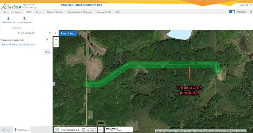
Contents

Revision History ....................................................... Error! Bookmark not defined.
    Disclaimer ...................................................................................................... 3
1.0 Introduction to PHAP ................................................................................... 4
•      1.1 Purpose of PHAP                                                                                           4
•      1.2 Pre-application Requirement                                                                               4
•      1.3 Technical Support                                                                                         4
•      1.4 Password & Username Maintenance                                                                           4
2.0 Accessing the PHAP application ................................................................ 4
•      2.1 Obtaining a GOA User Client ID                                                                            4
•      2.2 Accessing the Application                                                                                 6
3.0 Navigating in PHAP..................................................................................... 7
•      3.1 Activating the Tool Bar                                                                                   7
•      3.2 Using the Navigation Features                                                                             7
              o     3.2.1 Go to Location                                                                             7
              o     3.2.2 Open and close the coordinates widget                                                      7
              o     3.2.3 Right-click on the Map                                                                     8
•      3.3 Layers                                                                                                    8
4.0 How to use the PHAP application ............................................................. 10

• 4.1 Locating the PHAP tool ............................................................................ 10
• 4.2 Drawing a Power Line .............................................................................. 10
• 4.3 Uploading a Shapefile .............................................................................. 10
• 4.4 Inputting PHAP Parameters...................................................................... 11
• 4.5 PHAP Analysis ........................................................................................ 12
              o     4.5.1 Analysis Inputs .................................................................... 12
              o     4.5.2 Analyzing Fire Behaviour Potential ....................................... 12
              o     4.5.3 Tree Strike Risk Analysis ..................................................... 13
              o     4.5.4 PHAP Report and its Application .......................................... 14
              o     4.5.5 Submitting the PHAP Report ................................................ 14

Pr Line Hazard Assessment Plan User Guide | © 2021 Government of Alberta | July 21, 2021
                                                                                                                          2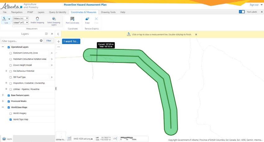
Disclaimer:
In this disclaimer provision:

“Crown” means Her Majesty the Queen in right of the Province of Alberta;

“Minister” means the Minister responsible of Alberta Agriculture and Forestry;

“Their employees” means and includes each, any and every officer, employee, servant and agent of either or both of the
Crown and the Minister and without limiting the generality of the foregoing, and includes employees of the Crown and the
Minister employed in Alberta Agriculture and Forestry;

“PHAP” means the Power Line Hazard Assessment Plan and all programs, hardware, documentation, functions and services
forming a part thereof or associated therewith.

The Crown, the Minister and their employees and the contractors and technical advisors of the aforesaid:

    (a) Make no warranty or representation, whether expressed or implied, to any person with respect to this material or
        documentation of PHAP or as to the service, performance, quality, merchantability or fitness of any part of the
        aforesaid for any purpose; and
    (b) Shall not be liable for any action, damages or claims, whether occasioned by negligence or otherwise, that any
        person, user, subscriber or any employees of the aforesaid may hereafter have, allege or become entitled to
        (including but not limited to any claim of third party contribution of indemnity, any economic or moral loss, or direct,
        immediate, special, indirect or consequential damages which do, may, or are alleged to arise as a result of:
    (c) The use of this material or documentation or PHAP or any service connection therewith; or
    (d) Any error or omissions in the data or any loss or partial loss of data or incomplete retrieval of information, even if any
        of all of the Crown, the Minister or their employees were advised of the possibility of such risk, action, claims or
        damages, including damages sustained or actions brought by third parties and claims made against the subscriber by
        third parties.

The entire risk of loss relating to or associated with the quality and performance of PHAP and any product and results thereof
shall be assumed by the subscriber and by any other user of PHAP.

Pr Line Hazard Assessment Plan User Guide | © 2021 Government of Alberta | July 21, 2021
                                                                                                                                 3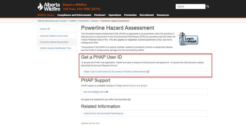
1.0 Introduction to PHAP
1.1 Purpose of PHAP
The purpose of a Power Line Hazard Assessment Plan (PHAP) is to help power line operators in reducing wildfire risk within
their operations, reducing the number of wildfire ignitions caused by power lines and improving partnerships for wildfire risk
reduction. This application can assist power line operators in identifying areas where hazard trees and/or potential vegetation
contacts may exist near their infrastructure that pose a risk of causing a wildfire, and identify areas where these or other power
line related ignitions might support large wildfire growth. Companies may also analyze the fire behaviour potential near assets
to inform mitigation activities to protect their infrastructure. This information can inform power line maintenance as well as the
design and engineering of the power line right-of-way.

NOTE: No information during the PHAP analysis is recorded, stored or collected by the Government of Alberta (GOA). Each
analysis, including data uploaded into the application, remains confidential to the individual or company conducting the
assessment.

1.2 Pre-application Requirement
The PHAP is applicable to all power lines within the province of Alberta. On public land, PHAPs are a pre-application
requirement for the approval of formal power line dispositions that fall within the Forest Protection Area (FPA). This also
applies to Vegetation Control Easements (VCE/RVC), but not to buried power lines. Where the proposed power line intersects
an identified FireSmart Community Zone, the PHAP must be referred to the local Agriculture and Forestry Wildfire Prevention
Officer.

1.3 Technical Support
This guide should provide an answer to the majority of questions that may arise during the PHAP process. If, after reviewing
the user guide, you still have questions or concerns regarding the application, you may email aws.service@gov.ab.ca. Support
is available Monday to Friday from 8:15 a.m. to 4:30 p.m.. When you are reporting an error or issue, please take a screen
capture and include it with your message, as this will help staff to narrow down the underlying cause.

1.4 Password & Username Maintenance
To manage your user name and password, activate your account and/or reset an expired password please visit the following
page: https://extern.wln.gov.ab.ca/help/User_Name_Maint.asp?a=RGE. When your password has been reset or account
changes have been made, you will be required to confirm these changes using the email you registered with before the
changes take effect.

2.0 Accessing the PHAP application
2.1 Obtaining a GOA User Client ID
Users requiring access to PHAP must first obtain a GOA Client ID to access industry online services. User accounts are
managed by Alberta Environment and Parks using the Active Directory Service (ADS) for multiple GOA applications. To obtain
a Client ID first navigate to the PHAP main page here: https://wildfire.alberta.ca/prevention/industry/powerline-hazard-
assessment-plan.aspx (Figure 2.0)

Pr Line Hazard Assessment Plan User Guide | © 2021 Government of Alberta | July 21, 2021
                                                                                                                                 4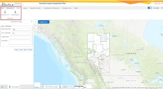
Important note: if you already have an external Client ID and password set, you then only require authorization for PHAP.
Simply email aws.service@gov.ab.ca with your request to access PHAP. Alternatively, you can use the self-registration
function when logging into PHAP.

FIGURE 2.0

This will take you the following page: https://www.alberta.ca/alberta-environment-and-parks-land-forms.aspx#toc-14

Navigate alphabetically to the following section and select “User ID Request Form-EDS-LAT-PCS-IWCP-FireWeb-PHAP”
(Figure 2.1).

FIGURE 2.1

Fill out the User ID form with the appropriate information and submit it to aep.acountmgt@gov.ca. Your application should be
processed within one business day. Note that for PHAP, there are no specific roles within the application. You will receive a
confirmation email once your application is processed and your account is activated.

Pr Line Hazard Assessment Plan User Guide | © 2021 Government of Alberta | July 21, 2021
                                                                                                                                5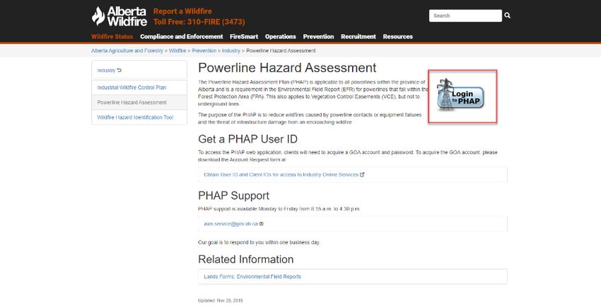
2.2 Accessing the Application
Once you have received your Client ID and password you can access the application from the PHAP external website here:
https://wildfire.alberta.ca/prevention/industry/powerline-hazard-assessment-plan.aspx Use the “Login to PHAP” tab as shown
in Figure 2.1. This application works best with Google Chrome and Microsoft Edge platforms.

FIGURE 2.1

From the PHAP homepage, you will be directed to the SecureXNET login page shown in Figure 2.2. Here your username and
password is authenticated against the ADS database. Enter your Client ID and password and select “GOA Client” from the
drop down box labelled “Account Type”. Usernames for PHAP are entered as firstname.lastname. If you have not logged into
Secure XNET in sixty days, your password will have expired and require a reset. Refer to section 1.4 for instructions.

FIGURE 2.2

Pr Line Hazard Assessment Plan User Guide | © 2021 Government of Alberta | July 21, 2021
                                                                                                                             6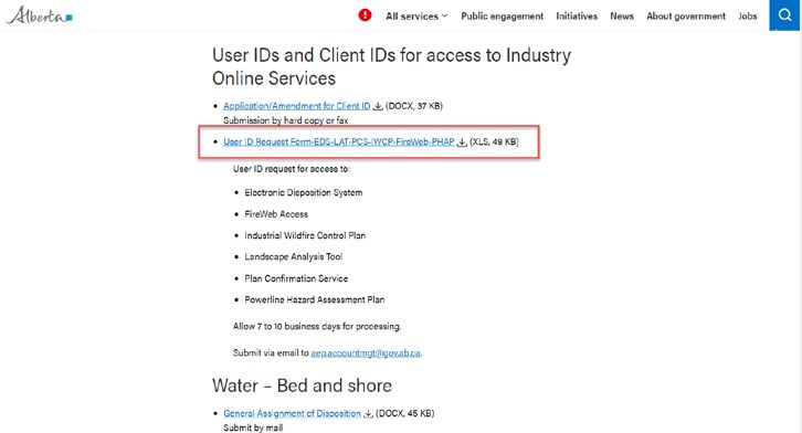
3.0 Navigating in PHAP

This section will highlight some of the more useful features in PHAP for navigating and running the analysis.

3.1 Activating the Tool Bar
When the initial PHAP page loads, the following tab menu should appear at the top of the screen.

If the tool bar tab is not visible, make sure that the “tool label” tab is checked on at the top right of the screen. You may also
need to select the “tools” icon at the top right hand side of the screen to display the tool bar.

3.2 Using the Navigation Features

3.2.1 Go to Location
When you first load the PHAP, you are directed to a provincial map view. A simple way to find your location of interest is from
the navigation tab. To the right is the “go to location” tab with a number of useful features for navigating by legal land location,
place name or address.

3.2.2 Open and close the coordinates widget
The “coordinate widget” is located in the lower left corner of the Map Frame and provides the user with the current coordinates
of the cursor. Click the widget to open and close the tool.

Pr Line Hazard Assessment Plan User Guide | © 2021 Government of Alberta | July 21, 2021
                                                                                                                                       7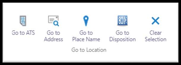
The user moves the cursor around the map and the tool will display
the coordinates in latitude and longitude, or the user may select
another coordinate system using the drop down tool.

WKID meaning: the spatial reference of a map, layer or inputs to and
outputs from a task. Each projected and geographic coordinate system is defined by either a well-known ID (WKID) or a
definition string (WKT). 1

3.2.3 Right-click on the Map
There are additional tools that the user can perform on a location by right-clicking on the map in the Map Frame.

When a location is right-clicked, a green tag appears and a menu opens with the coordinates of the location in decimal
degrees format and displays a variety of functions you can perform.

3.3 Layers
A number of data layers are provided to the user to inform the PHAP analysis. To activate the layers click on “layer list”. To
view the map legend information about each layer select “legend”.

Operational layers: the layers within PHAP that are most pertinent to supporting wildfire risk analysis for power lines are the
following:

           a.   FireSmart Community Zone: areas near communities where complete debris disposal is needed for timber
                harvest operations, as well as a required referral of the completed PHAP to the local Wildfire Prevention Officer
                to support community FireSmart planning.
           b.   FireSmart Consultative Notation Area (CNT): areas where consultation with Alberta Wildfire is required prior to
                approval of new disposition approvals (not all community zones overlap with a CNT).

1
    The WKID meaning was taken from the ArcGIS for Developers site:
     https://developers.arcgis.com/javascript/3/jsapi/spatialreference-amd.html
Pr Line Hazard Assessment Plan User Guide | © 2021 Government of Alberta | July 21, 2021
                                                                                                                                    8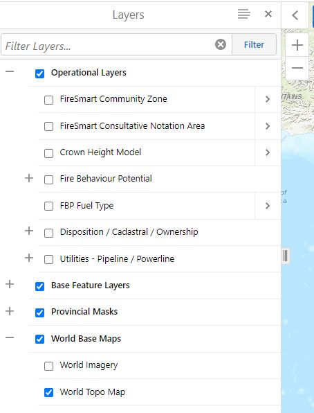
c.   Power line data: power line and pole infrastructure data is provided for most of the major power line operators in
               Alberta.
          d.   Crown Height Model (CHM): canopy height data is derived from a number of LiDAR datasets that have been
               stitched together. It references the tallest tree within the defined 5x5 metre grid cell. The currency of this data
               depends on the date of capture, which is available as a sub-layer.
          e.   Fire Behaviour Potential (FBP): Head Fire Intensity (HFI) that has been re-classed and weighted by Crown
               Fraction Burned (CFB), the percentage of crown consumed. The CFB weighting represents the potential for
               ember generation, which would increase the spread of the wildfire through ember ignition. Grass fuel types are
               not weighted by CFB. Each class indicates the difficulty of controlling the spread of a wildfire on a 90th percentile
               weather day with “low” being the easiest to control to “extreme” having a high likelihood of escaping control.
          f.   FBP fuel types: fuel types as defined by the Canadian Forest Fire Behaviour Prediction System, descriptions can
               be found here: https://cwfis.cfs.nrcan.gc.ca/background/fueltypes/d1
          g.   Disposition/ Cadastral/ Ownership: up to date disposition information for public lands in Alberta, as well as crown
               or titled ownership and cadastral data.
          h.   Mountain pine beetle data: red attack tree survey data is available for the previous 15 years. Larger dots indicate
               a higher count of red trees for that surveyed location.

World base maps
       a. World imagery: a combination of high and low-resolution satellite and aerial imagery for most of the world from
           multiple sources, typically within 3-5 years of currency.

Tip: layer names may be partially displayed in the layer list due to their length. To view the full layer title, expand the
section by clicking on the tab on the right side of the layer menu (Figure 3.1).

FIGURE 3.1

Pr Line Hazard Assessment Plan User Guide | © 2021 Government of Alberta | July 21, 2021
                                                                                                                                   9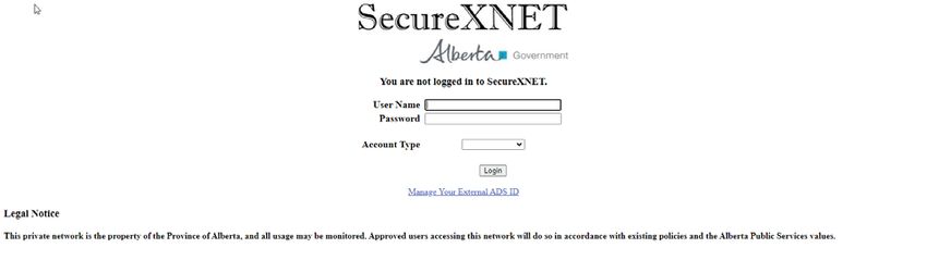
4.0 How to use the PHAP application
4.1 Locating the PHAP tool
To generate a PHAP, the user must select the “PHAP” tab at the top left of the screen (Figure 4.0). This will display two
options to either “draw a power line” or “upload a shapefile”.

FIGURE 4.0

4.2 Drawing a Power Line
Drawing a power line is a simple way to draw a planned or existing right-of-way (ROW) on the map for analysis purposes. This
may be used when small segments need to be analyzed, if a shapefile is not readily available or when analyzing possible
locations for a future ROW. Simply select “draw a power line”, which opens up the menu (Figure 4.0). At the bottom of the
menu, select the “draw” button. Zoom into the location of interest and click once to start the power line segment. Each click will
allow you to change the direction of the line segment. To end the drawing, double click the mouse button. To erase the power
line select “erase”.

Tip: displaying a combination of disposition and power line data in combination with world imagery will help to
ensure that you have correctly drawn in the power line in reference with current infrastructure and other land use
activities.

4.3 Uploading a Shapefile
Uploading a shapefile into PHAP is the most efficient and accurate method for larger right-of-ways or sections of line that will
be analyzed. Select “upload shapefile” from the PHAP menu tab (Figure 4.0) and select “choose file”. Browse to where the file
is located and select the .shp, .dbf and .prj files. All three files must be included for the upload to work successfully. The
shapefile must be in the polyline format. If a point or polygon is used, you will receive an error message.

Pr Line Hazard Assessment Plan User Guide | © 2021 Government of Alberta | July 21, 2021
                                                                                                                                10
4.4 Inputting PHAP Parameters
The following parameters must be known and inputted correctly prior to running the analysis (Figure 4.1).
1. Buffer value (M): this is the full width in metres, (both sides of the line) of the area that you wish to be analyzed for
tree strike and fire potential risk. The default buffer size is 500m. In the example in Figure 4.2 below, a buffer width of
100m was chosen for the analysis.
FIGURE 4.2
2. Tree height: tree height must pre-determined by the user for the analysis based on a company’s risk tolerance
factoring in line strike probability, clear width and other factors. This informs the application of the tree height
threshold to use within the analysis.
3. Project name: the unique identifier of the name of the project being analyzed.
4. Comments: optional information to include about the analysis.
Figure 4.1
5. Once you are satisfied with the input parameters, select “run” to start the PHAP analysis.
Pr Line Hazard Assessment Plan User Guide | © 2021 Government of Alberta | July 21, 2021
114.5 PHAP Analysis
4.5.1 Analysis Inputs
The PHAP analysis generally takes a minute or less to run for small to medium lines. Larger lines or areas will take longer to
analyze.
1. A buffer is automatically drawn around the centerline according to the inputted width by the user.
2. The application analyses the canopy height model to determine which trees within the buffer meet the minimum
determined height (Figure 4.2).
3. The percent total area of fire behaviour potential for spring, summer and fall that overlap with the buffer is calculated.
FIGURE 4.2
PHAP analysis with a 50-metre buffer showing trees in grey boxes that are over 25 metres in height.
4.5.2 Analyzing Fire Behaviour Potential
Fire behaviour potential is a representation of fire intensity that has been weighted by crown fraction burn and re-classed into
categories from low to extreme. It is an estimate of the difficulty of controlling a fire. Intensity was determined using historical
90th percentile weather inputs displayed in a 100 metre x100 meter rasterized cell. Low fire potential indicates that ignition
within this cell will be relatively easy to suppress, increasing proportionally to extreme potential, meaning that fires will prove
extremely difficult to control. Crown fraction burn represents the portion of crown foliage that is consumed by wildfire. The
higher the consumption, the higher likelihood of ember spotting and control difficulty.
If the power line right-of-way transects areas of high to extreme fire potential, then there is a good chance the power line will
be impacted by radiant heat and embers when a fire occurs adjacent to this ROW. Seasonality is important when considering
fire behaviour potential. In the boreal forest in Alberta, the majority of the larger catastrophic wildfires have occurred during
spring when conditions of low fuel moisture and cured grass exist with significant drying supported by high-pressure weather
systems. Typically, these types of spring fires do not occur in the eastern slopes, which are more prone to larger fires in the fall
when the grass has cured. Deciduous (poplar) fuel types typically slow the fire spread in summer months when grass and
deciduous species have fully leafed out, making them less able to sustain fire spread. The boreal forest also experiences large
fires in the summer and early fall months generally driven by spruce, pine and conifer leading mixedwood fuel types. Dry
springs with strong wind events are particularly problematic for power line operators as stands of older aspen and
mixedwood stands support both a high risk of ignition and rapid fire spread.
Pr Line Hazard Assessment Plan User Guide | © 2021 Government of Alberta | July 21, 2021
124.5.3 Tree Strike Risk Analysis
The PHAP application can help identify which stands contain trees of sufficient height to pose a risk to conductors. The CHM
buffer width determines the area in which the CHM is analyzed to identify trees which meet the chosen threshold. The current
CHM model identifies the height of the dominant trees within a 25x25 metre cell.
Aspen and white spruce are common species that cause tree strikes on power line conductors. Approximately 70 per cent of
power line related wildfires are caused by tree strikes normally occurring during gusty wind events. When planning a new
ROW or assessing risk to older lines, it is encouraged that companies use this analysis feature to identify stands that pose a
risk of striking the conductor.
Note that the CHM layer has a “date of capture” layer that shows the year the LiDAR data was collected. For subsequent
years, increased tree growth can be estimated using growth and yield curves. The fuel type layer is also updated annually,
taking into account the previous years harvesting and wildfire data which can be overlaid with the fire potential to confirm the
validity of the current fuels.
4.5.3.1 Informing Tree Freeing and Maintenance Programs
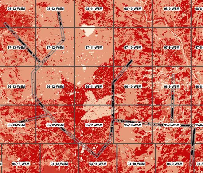
The tree risk analysis can be used to analyze larger networks of power lines for potential tree strike risk. Simply upload a
shapefile with the area to be analyzed and run the PHAP. The CHM analysis will give you an idea of where trees may be tall
enough to strike the line based on your inputs. An example of this is shown in Figure 4.3 below. Areas of darker red indicate
extreme fire behaviour potential, black areas indicate where the tree heights meet or exceed the chosen threshold. Note that
the canopy height model is based on the LiDAR capture date which is noted in the layer named “LiDAR Acquisition
Information”; adjustments can be made to the height used in the analysis to capture height growth since capture date.
FIGURE 4.3
Pr Line Hazard Assessment Plan User Guide | © 2021 Government of Alberta | July 21, 2021
134.5.4 PHAP Report and its Application
PHAP produces a report summarizing the outputs of the analysis in a printable .pdf format. Spring, summer and fall fire
behaviour potential are analyzed within each buffer. The total breakdown is presented using basic analytics.
CHM raster cells that were identified as meeting the height threshold are outlined with black hashed rectangles.
It is recommended that companies look closely at reducing wildfires caused by tree strikes near communities where there are
areas of high fire potential that are adjacent to lines. If there is a risk of a tree strike and the fire potential is low to moderate in
the spring, then a fire igniting here will generally be easier to control.
Strategies for reducing the risk of a wildfire caused by a power line include:
1. ROW widening: in select areas near a wildland-urban interface (WUI) community, where there is significant tree strike
risk and very high to extreme fire potential, a slightly larger ROW may prove beneficial in reducing risk to the
community.
2. System hardening: replacing older infrastructure in areas where there is very high to extreme fire potential is
recommended. Not only do you decrease the likelihood of power-line-caused fires due to current leakage and faults,
you also increase the resiliency of the infrastructure to large wildfires and reduce the chance of outages.
3. Increased tree-free programs and risk patrols in areas of high to extreme spring fire risk where there is a high
probability of tree strikes near values such as communities or critical infrastructure.
4.5.5 Submitting the PHAP Report
The report must be included in the pre-application for new easements. Although Alberta Environment and Parks will refer the
PHAP to Alberta Agriculture and Forestry, it is recommended that the power line company reach out to the local Wildfire
Prevention Officer in advance to discuss how the new ROW could affect community FireSmart planning. The area contact
information is provided below.
Calgary: (403) 297-8800
Edson: (780) 723-8527
Fort McMurray: (780) 743-7125
Grande Prairie: (780) 538-5560
High Level: (780) 926-3761
Lac La Biche: (780) 623-5388
Peace River: (780) 624-6190
Rocky Mountain House: (403) 845-8272
Slave Lake: (780) 849-7431
Whitecourt: (780) 778-7153
Pr Line Hazard Assessment Plan User Guide | © 2021 Government of Alberta | July 21, 2021
14You can also read