Pre Run Information Pack November 2018 - Everything you wanted to know, but were too afraid to ask! - Running Wild
←
→
Page content transcription
If your browser does not render page correctly, please read the page content below
Pre Run Information Pack
             November 2018
Everything you wanted to know, but were too afraid to ask!

                                Australia’s toughest trail runs
                                160/100/60/36km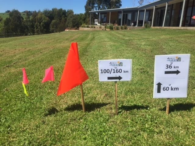
Welcome to the 2018 Alpine Challenge, detailed below is some information for the event, please read this
information prior to the event as this year we will not be holding a pre run briefing, however we will hold a
Q & A session. The information in this pack supersedes any information on the website.
The Q & A session on Friday 23 November will focus on any concerns you may have re; course, water, safety,
checkpoints, drop bags, pacers etc for each distance and especially for the 100 milers and, what to do to avoid
a DNF and finish the curse - oops I meant course plus an update on any changes to the course.
There will be a mini briefing and roll call on Saturday morning immediately prior to the start of each race to
update you on any essential course changes due to flooded rivers, snow, storms, MTB riders, etc .
We will check all runners into the start area to ensure we have a complete list of starters. Please do not be late.
Key Information
Registration/Gear check from 3 PM to 9PM Friday 23 November Falls Creek - Slalom Plaza, FCRM Board Room
Pre run dinner from 6 PM to 7.30 Friday 23 November Falls Creek - Slalom Plaza QT
Q&A Session 1 6.30 – 7.00 23 November Falls Creek - Slalom Plaza, FCRM Lounge
Session 2 7.15 – 7.45 23 November Falls Creek - Slalom Plaza, FCRM Lounge
Run check in / roll call / start
100 mile/100 km Run Pre-race check in: 04:10 A.M. Slalom Plaza, Falls Creek
Start time: 04:30 A.M. Saturday
36/60 km Run Pre-race check in: 08:10 A.M. Slalom Plaza, Falls Creek
Start time: 08:30 A.M. Saturday
---------------------------------------------------------------------------------------------------------------------------------
Registration:
Race numbers / PLBs and race packs will be given out at Registration on Friday afternoon.
Gear checks will be conducted at Registration, please bring your running kit with you.
NB: Where the safety list states spare thermal top and bottom this means you can start the day wearing them
and then place them in your pack.
NBB: – No gear = No start
At registration we will require: confirmation of your phone number, emergency phone number and support
crew contact numbers.
International Entrants:
On arrival in Australia purchase an Australian SIM card & insert this into an unlocked phone. Telstra has the
best coverage over the Alpine Challenge course. You can buy SIM cards in many airports on arrival and in
supermarkets, news agencies, petrol stations. You can buy SIM cards for just $2 and top up using pre-paid
vouchers. This is essential so that we can contact you via SMS or phone in the event of an emergency during
the run.
Navigation – how not to get lost – Avenza downloadable maps
Please download the Avenza maps for your smart phone, these will show your location in real time on the
course. To download follow the instructions here … http://www.terrainium.com.au/blog/alpine-
challenge-2017/
NB – This year’s final 2km is slightly different from the Avenza map due to the National MTB championships
being held at Falls Creek. The course will be marked to the finish from Pretty Valley.
NNB – you must carry a hard copy map as part of your mandatory gear - you can print this off from the
website.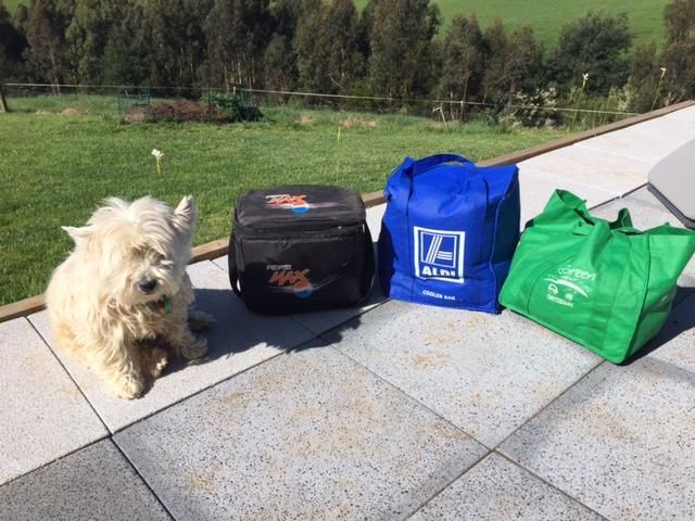
Drop Bags: 100km /100 mile runners only
Please bring your Drop Bags to registration on Friday.
Drop bags must be: - Small, (no larger than a Coles or Woolies cloth shopping
bag) – See photo
- Have your name and race number clearly printed,
- Marked with the location that the drop bag is to go to.
- Have contents packed in a waterproof bag
- Not too heavy
Runners can leave Drop Bags clearly marked with
their; Name, Race Number / Checkpoint
(Langfords Gap / Loch car park / Pretty Valley
Pondage)
at Registration on Friday between 3PM and 9PM.
NB: 160km runners - Drop bags for Loch Car park not delivered by 9PM Friday are not guaranteed delivery.
Drop Bag return: Runners must claim their drop bags after the run by 10.00am on the Monday from the
oversnow transport centre. The organisers are not responsible for returning any Drop Bags (and their
contents) to runners if they are unclaimed by 10.00am on Monday after the run.
Although we will do our best to ensure your drop bags are;
a) delivered
b) intact to checkpoints and
c) returned to the finish,
we are not responsible for lost or damaged drop bags and their contents.
Drop bags are of necessity stacked for transport, so they must be robust and their contents protected in leak-
proof and crush proof (where appropriate) containers as well as protected from rain / water.
DO NOT PUT VALUABLES IN DROP BAGS!
Drop bag locations:
36/60km – No drop bags
100km – Langfords Gap/Pretty Valley
100 Mile – Langfords Gap / Loch Car park /Pretty Valley
NB be aware that in past years drop bags / support crews have failed to meet runners at Loch Car Park due to
road closures as a result of tree falls / slippages – please carry extra supplies – just in case 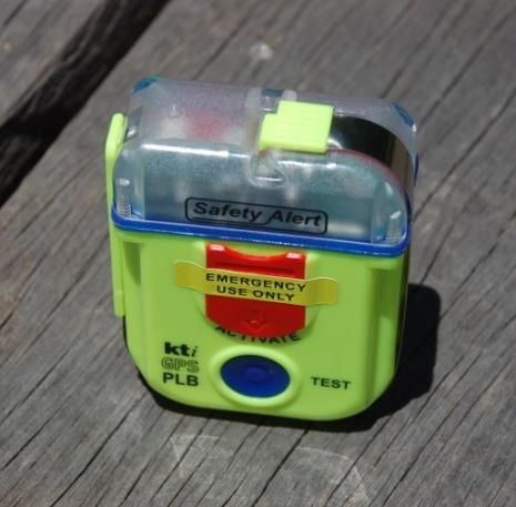
Alpine Challenge 2018 - Cut Off times / Checkpoints – updated 10/9/18
 Marshalls will be at the check points below.
 All participants MUST check in and have their times recorded at ALL checkpoints. It is your responsibility to ensure that your
 number has been recorded. If your number is not recorded you may be disqualified.

  If you arrive at the checkpoint after the cut off you will not be permitted to proceed.
 If Marshalls / Medical advisers feel your health / pace would place you in difficulty of continuing, or due to adverse weather
 conditions the Marshals may direct you NOT to continue.

 The decision of a Marshall/ Medical adviser is final. You will NOT be permitted to proceed after the times below if you are late.

 Cut off times specified below are the times by which you must exit the check point. There will be random gear checks at
 checkpoints, failure to have ALL the mandatory safety gear will lead to participants being withdrawn from the event.

 Relay Team change over: Relay teams may change over members at the checkpoints.
 In the tables below there are target times – you should aim to be at the checkpoint by this time if you want to meet the cut off.
 If you are late meeting a target time you may be allowed to proceed to a checkpoint that has a cut off time. If you are late
 meeting a cut off time you will be pulled from the event.

          Cut Offs—36 km - Start 0830 Saturday – 9 hour cut off
Checkpoint                       Cut Off      Distance km Leg time hr Total km Elevation m                    Refreshments

                                 14.00 Sat        24.5          5:30           24.5       +1140 m   Water - Electrolyte - Fruit - Chips
Warby Cnr
                                                                                                         - Chocolate - Sweets

Falls Creek                      17.30 Sat        11.5          3:30           36

          Cut Offs—60 km - Start 0830 Saturday – 18 hour cut off
                                 Cut Off      Distance    Leg time     Total          Elevation m             Refreshments
Checkpoint       Target time                     km          hr         km

                                 14.00 Sat      24.5        5:30       24.5            +1140 m      Water - Electrolyte - Fruit - Chips
Warby Cnr (1)
                                                                                                         - Chocolate - Sweets

                                 16.00 Sat       9.0        2:00       33.5                         Water - Electrolyte - Fruit - Chips
Langfords Gap
                                                                                                    - Chocolate – Sweets

Pole 333 (1)     10:00 Sat                       14         6:00       47.5             +200m            Water - Chips - Sweets

Pretty Valley                   00:00 Sun         5         2:00       53.5              +200         Water – Fruit - Chips - Sweets

Falls Creek                     02:30 Sun        9.0        2:30       62.5             +200m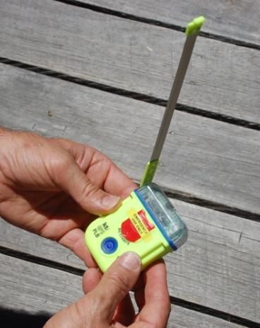
Cut Offs 100 km – Start 0430 – 26 hour cut off
                                        Cut Off     Distance   Leg time   Total   Elevation              Refreshments
Checkpoint                Target time                  km
                                                                  hr       km        m

                                        10:30 Sat     24.5      5:30      24.5    +1140 m Water - Electrolyte - Fruit - Chips -
Warby Cnr (1)
                                                                                                 Chocolate - Sweets

Cleve Cole Hut (Bogong)                 16:00 Sat     14        4:00      38.5    +1000/-            Water - Chips - Sweets
                                                                                   840m

                                                      26        5:30      64.5     +660/-     Water - Electrolyte - Fruit - Chips -
Warby Cnr (2)             20:00 Sat
                                                                                   790m              Chocolate - Sweets

                                        21:30 Sat     9.0        1.30     72.5                Water - Electrolyte - Fruit - Chips -
Langfords Gap
                                                                                              Chocolate – Sweets - Drop Bags

Pole 333 (1)              01:30 Sun                   14        3:00      86.5     +200m             Water - Chips - Sweets

                                        03:30 Sun      5        1:30      91.5      +200        Water – Fruit - Chips - Sweets –
Pretty Valley Pondage
                                                                                                           Drop Bags

Falls Creek                             06:30 Sun     9.0       2:00      100.5    +200m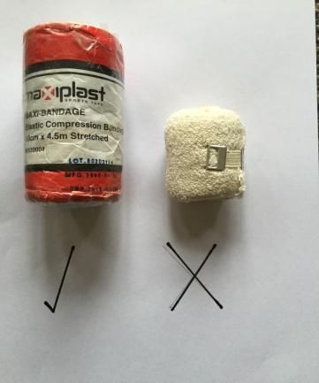
Cut Offs 100 mile – Start 0430 – 42 hour cut off
                                          Cut Off     Distance    Leg time     Total   Elevation              Refreshments
Checkpoint                 Target time                   km
                                                                     hr         km         m

                                         10:00 Sat      24.5        5:30       24.5     +1140 m Water - Electrolyte - Fruit - Chips -
Warby Cnr (1)
                                                                                                       Chocolate - Sweets

Cleve Cole Hut (Mt                       15:30 Sat       14         5.30       38.5     +1000/-           Water - Chips - Sweets
                                                                                         840m

                                                         26         5:30       64.5      +660/-    Water - Electrolyte - Fruit - Chips -
Warby Cnr (2)              19:30 Sat
                                                                                         790m             Chocolate - Sweets

                                         21:00 Sat      9.0         1.30       68.5                Water - Electrolyte - Fruit - Chips -
Langfords Gap
                                                                                                   Chocolate – Sweets - Drop Bags

Pole 333 (1)                             24:00 Sat       14         3:00       92.5      +200m            Water - Chips - Sweets

                                         04:00 Sun      14.5        4:00       107       +700/-    Water - Electrolyte - Tea - Coffee -
Loch Carpark                                                                             460m       Soup – Noodles - Fruit - Chips -
                                                                                                               Drop Bags

Harrietville (Snowline                   10:00 Sun       16         6:00       123.5    -1300m     Water - Electrolyte - Tea - Coffee -
                                                                                                    Soup – Noodles - Fruit - Chips

Diamantina Spur            14:00 Sun                    13.5        4:00       137       +1400                      N/A

                                                        13.5        5:00       150.5     +700/-     Water – Chips - Sweets (Pole 333
                                                                                         460m       CP may relocate to PV on Sunday
Pole 333                   19:00 Sun
                                                                                                               morning
                                                                                                   depending on weather conditions)

                                         20:30 Sun       5          1:30       155.5      +200       Water – Fruit - Chips - Sweets -
Pretty Valley Pondage
                                                                                                               Drop Bags

Falls Creek                              22.30 Sun      9.0         2:00       164.5     +200m

           Water is available from rivers, streams and soaks. Parks Victoria recommends treating all water.
           Given the large number of runners and the remoteness of some checkpoints we recommend that you take water
           from streams and rivers when it is available, do not rely on water being available at all checkpoints.

           Plastic cups will not be available for drinking at the refreshment points. Competitors must be in possession of a
           cup or other container suitable for personal use.

           Each runner must ensure that they carry the minimum amount of water expected as compulsory equipment
           on departure from each refreshment point.

           NB: 100/160km runners - There is a 10km uphill section from Big River to Warby Corner where there is NO water.
           Many runners do this section in the heat of the day. Take on water at Big River.
Alpine Challenge ‐ Event Rules
     The following are a summary of the full set of rules for the event (see website). These rules have been developed to
     enhance participant safety and support the event organiser’s in maintaining a high safety standard. Please accept the rules
     in the spirit of the event.

1.   The organiser’s reserve the right to alter the course without notice and / or cancel the event in consultation with and under
     the direction of Emergency Service agencies.

2.   Participants must register, collect their safety pack and have their gear checked prior to commencement of the event.

3.   Team members must check in / out together at each checkpoint.

4.   All participants must check in / out at all checkpoints.

5.   Participants must offer assistance to competitors in distress failure to do so will lead to disqualification from the event.

6.   Participants must advise the next checkpoint (ASAR) that they come to, of any runner in distress.

7.   Participants injured / exhausted or suffering from exposure should be brought to the nearest checkpoint for assistance. If
     the injury is serious. In the event of hypothermia, onsite assistance should be provided and assistance sought from the
     event organisers on the emergency contact number provided on the back of your race bib.

8.   Under no circumstances are incapacitated injured / distressed participants to be left unattended.

9.   Participants & Support Crew must obey all directions / instructions given by marshals / SAR personnel. Failure to obey a
     safety instruction from an event marshal, SAR personnel or emergency services will lead to their runner being disqualified.

10. Cut offs at checkpoints will be enforced by marshals and are non‐negotiable.

11. Participants wishing to withdraw during the event must report to the nearest checkpoint

12. If a participant leaves the track for a toilet stop, they must leave their pack with race number (ribbon) on the track.

13. Participants leaving the track or checkpoints to sleep, or for any other reason must do so from a designated checkpoint
    (toilet stops excepted). They must notify the checkpoint marshal of their intention and estimated return time.

14. Race bibs must be worn at all times on the front of the body, and ribbons with race numbers displayed on packs.

15. Participants are required to carry a mobile phone during the event – a minimum of 2 per team, or one for each solo runner,
    all runners / teams should have at least one spare phone recharge pack.

16. Participants (100/160km only) are issued with a Personal Location Beacon for the duration of the event and are responsible
    for its return on completion of the Event. Charges will be incurred at the rate of $10 AUD per day for late return.

17. Participants are not permitted to meet support crew at any location except checkpoints (Warby Corner /Langfords
    Gap/Pole 333 / Loch Carpark / Harrietville and Pretty Valley. Support crew are allowed to run with solo runners but cannot
    lead them (pace) or carry any of the race participant’s equipment. Support crews running/walking with solo/team members
    must carry the full list of mandatory safety equipment.

18. Support crew may accompany runners from Pole 333 onwards but only for a maximum of 2 stages. Stages are defined as:
    1) Pole 333 – Loch Car Park 2) Loch Car park to Harrietville 3) Harrietville – Pole 333/PVP 4) Pole 333/PVP - Finish

19. Mandatory safety equipment will be checked prior to and during the event.
    Participant found with equipment that does not meet the minimum mandatory safety equipment specifications will not be
    permitted to start (refer to mandatory safety equipment list).
    Participants found without the mandatory equipment during the event will be withdrawn and disqualified.
Snake Bite – Mandatory Safety Equipment
Want a one stop first aid kit https://trailsurvivor.com.au/products/trailsurvivor-ultra-running-first-aid-kit
Please watch this video on snake bandaging by trail runner Dr Cheryl Martin
https://youtu.be/acnGPNmmOIw
The white crepe bandage on the right is NOT acceptable. Ensure that, as a minimum you bring
an elastic compression bandage 10cm in size. You can obtain these from most chemist stores.
A crepe bandage may assist in covering the bite wound.
Recent research shows that the effectiveness of traditional crepe bandages is significantly
lower than modern elastic bandages in treating a snake bite, and even elastic bandages will be
compromised if they’re not applied at the correct pressure. In most cases it has been found
that not enough pressure is applied when using these bandages, decreasing their efficacy.
In terms of bandaging technique, firm pressure bandaging is required to restrict the lymphatic flow of toxins after snake
bite. Strict limb immobilisation is necessary to minimise lymphatic flow, since walking after snake bite will inevitably
result in the spread of toxins throughout the body, and render any pressure bandaging useless. More detailed insight
can be gained from Australian Venom Research Unity – First aid for snakebite
Gaiters are likely to be effective against snake bite as Australian snakes generally have small fangs. If the snake were
to bite through a closely woven, thick gaiter, the venom will either be absorbed by the gaiter itself, or, due to its
position away from the calf, will lead to the venom running down the inside rather than making contact with skin.
Source: Wild Magazine, Dec 2014
PLB - Mandatory Safety Gear (100/160km runners)
How to use your PLB: User Guide: KTI SA2G: Personal Locator Beacon
Notes for Users: DO NOT test the device – It has been tested. Testing uses precious battery life. Only operate
in a situation of grave and imminent danger.
To Activate:
1. Slide RED protective cover downwards to access the button. ( Fig 1)
2. Release antenna end-lock by sliding forward and set antenna to vertical position. (Fig 2 & 3)
3. Press and hold RED activation button until Green light starts flashing then release button. (Strobe light
will also flash) (Fig 3.)
4. Ensure that PLB is above the water with the antenna in the vertical/upright position,.
5. Leave beacon operating continuously until rescued.
To Deactivate:
Press the blue TEST button until Strobe light stops flashing.Mandatory Safety Gear – 36/60/100/160km
This list has been prepared based on running in good to mild conditions. It should be treated as your minimum safety gear
and should be adjusted upwards in terms of quality, and quantity of gear depending on conditions. Many runners aim to take
the lightest and smallest amount of gear with them. This will not protect you in the Victorian Alps in cold, wet and windy
conditions. The 100 mile event has an average 34% DNF rate because people continue to underestimate the conditions.
All participants are advised that failure to have the approved mandatory safety equipment at the event and at gear checks
during the event will result in disqualification and the participant being removed from the event.
All participants must provide and carry with them the following minimum safety equipment. X means you must have it.
Mandatory Items 100/160k 60k 36k
Waterproof & windproof jacket with hood,(gortex, pertex, entrant, japara, nylon etc) X X X
Waterproof & windproof pants, (gortex, pertex, entrant, japara, nylon or similar) X X X
Spare long sleeved thermal top and long johns (polypropylene, wool or similar). May be X X X
worn at the start of the run.
NB: Not acceptable - Cotton, coolmax, lycra & any non thermal compression garment.
Beanie and or hat and or balaclava or buff (1 only) X X X
Windproof & waterproof gloves (large size dishwashing gloves are waterproof ) X X X
Hard copy waterproof map of the area and course notes (laminated or in a waterproof X X X
map case or zip lock bag). Spatial Vision,Bogong Alpine Area 1:50,000 or off the website
Compass or GPS plus spare batteries for GPS. Find out how to use your map and compass X X X
here http://www.gizmodo.com.au/2015/01/how-to-use-a-map-and-compass/
Lighter or waterproof matches X X X
Whistle X X X
First Aid kit including X X X
Emergency space blanket/bag/light bivvi sack (1 only) or equivalent.
Personal First aid requirements, bandaids, antiseptic, painkillers etc
10 cm elastic bandage for snake bites/sprains.
Fully charged mobile phone and portable mini power bank (1 phone per solo runner/2 X X X
per team or relay team—Telstra provides the best coverage)
Torch/headlamp and spare batteries X X
Back up torch/headlamp (including spare batteries) X
Food—for the run and emergency food if lost (energy chocolate is good) X X X
Water—minimum 2 litres capacity. More recommended if forecast is hot X
Water—minimum 1 litres capacity. More recommended if forecast is hot X Y
Personal cup or other suitable container for drinking at the refreshment points (water X X X
bottle is valid)
Waterproof bag for spare clothing (plastic bags/zip lock bags or dry sacks are fine) X X X
Sun screen X X X
Personal Location Beacon or similar (1 per solo/team, provided in race pack)
X
Emergency heat pack (provided in race pack) X X
Race number (provided in race pack) X X X
Tape with race number for pack (provided in race pack) X X X
Ziplock bag – for your rubbish (provided in race pack) X X X
Unacceptable gear
If you bring this equipment, you will NOT be permitted to start - Water resistant jackets/over-pants, Jacket without a
hood, poncho, “Skins” or equivalent as thermals, Non elasticised snake bite bandage less than 10 cm.What to do if you think you are, or you are lost, injured and need help
(But you won’t get lost cos you have the Avenza download maps )
What to do if you are lost or geographically embarrassed.
1) Stop, stay calm, get out your Smart phone and open your Avenza map. Locate yourself, locate the
route, move back to the route
2) If you do not have a smart phone, get out your map and compass and course notes. Orientate your
map, read the map to ground, read your trip notes and try and work out where you are.
3) If you can’t work out your location and you are still on the track, backtrack to your last known point.
Find yourself and then continue on.
4) If all else fails, call Paul on the emergency number listed on the back of your race bib. If you have
problems getting through, ie only one bar showing in signal strength – try sending an SMS. Stay calm,
do not panic, do not continue moving forward. Stay in one location.
5) Use your whistle to attract attention – 3 long blasts, wait 60 seconds – then another three long blasts
– listen for a reply whistle – 3 short blasts.
6) If you make contact and need to give your GPS coordinates from your mobile phone, follow the steps
below. This will help the ASAR team locate you and if necessary come and get you
How can I display current GPS coordinates on my phone?
1) You can download the free app “Emergency+ “to your smartphone
2) iPhone
You can use your iPhone's built in GPS to display the latitude and longitude coordinates of your current
location. Follow these steps to find your location coordinates in degrees, minutes and seconds:
Make sure that Location Services is ON. Navigate to Settings -> Location Services -> ON 2. In the list of
apps under Location Services, make sure Compass is ON 3. Press the Home button to exit Settings 4.
Open the Compass app
Your current GPS coordinates are displayed at the bottom of the screen in deg.min.sec.
3) Android Phones
Download a free GPS coordinates app such as: My GPS Coordinates or GPS Coordinates
Ensure GPS satellites in Settings, Location access is turned on
Learn about finding your GPS Coordinates using Google maps on your smart phone
https://www.youtube.com/watch?v=HgL_PzImfO0
When should I activate my PLB
In the event that you are seriously lost, and / or injured and cannot make contact with anyone by phone, SMS,
whistle blasts or calling you may as a last resort have to activate your PLB.Course Markings In the first 90km you can expect to see around 10 markers. These are at critical junctions. Once you are past critical junction navigation is reasonable plus you have your map, course notes and Avenza map. Please make sure you carry them and they are easily accessible. In the last 2 km through the village there are around 100 markers and directional signs. Directional arrows are at major junctions Large orange flag – 160km – Washington Creek approx 10 in 200m Pink flag – standard markers Pink flag with reflective tape – Across the “Desert” – Mount McKay to Home Trail – Falls Creek village
Water Locations
100 /160 km (black 100/160, red 160 only)

                       Section                                Water
Falls Creek—Spion Kopje —Warby Corner          Rocky Valley Creek, stream
Warby Corner—Duane Spur—Big River              Big River
Big River—T Spur—Mt Bogong                     Madisons Ck, Cleve Cole Hut
Mt Bogong—Quartz Ridge—Big River               Big River
                                               Big River, No water for 12 km.
Big River—Timms Spur—Warby Corner
                                               Warby Checkpoint.
Warby Corner—Mt Nelse—Langfords Gap            Creeks, Checkpoint
Langfords Gap—Cope Hut—Pole 333                Aqueduct, creek
Pole 333—Cobungra River—Dibbins Hut            Cobungra River
                                               Derrick Hut – small soak,
Dibbins Hut—Swindlers Spur—Loch C/P
                                               Loch Checkpoint
Loch Car park—Bon Accord Spur—Harrietville     Washington Ck, Harrietville
Harrietville—Bungalow Spur—Mt Feathertop       Soak, Federation Hut
Mt Feathertop—Diamantina Spur—Westons Hut—Pole West Kiewa River, Creek at
333                                            Westons
Pole 333—Pretty Valley Pondage—Falls Creek     Pretty Valley Pondage, aid station

60 km

                 Section                            Water
Falls Creek—Spion Kopje F/t—Warby Corner       Rocky Valley Creek, stream
Warby Corner—Mt Nelse—Langfords Gap            Creeks, Langfords
Langfords Gap—Cope Hut—Pole 333                Aqueduct, creek

36 km

                 Section                             Water
Falls Creek—Spion Kopje F/t—Warby Corner        Rocky Valley Creek, stream
Warby Corner—Mt Nelse—Heathy turn off           Creeks
Heathy – Finish                                 Creeks / Aqueduct
Take part in the “I do not throw my rubbish away” campaign
Running Wild is committed to preserving the unique environments we run in. Every year sweeps pick up
rubbish dropped by runners – wrappers, Gels etc, so we would encourage you to join us in this endeavour.
The purpose of the campaign is to raise awareness of runners to respect nature and the environment. For this
reason, we encourage you to:
Pick up any rubbish you see on the trail;
Use the snap lock bags that are in your race pack
Utilise the garbage bags at checkpoint / refreshment area;
Use your own cup / bottle at drink stations – to reduce waste we will no longer provide plastic /paper
cups;
Note that we will disqualify anyone found throwing /dropping garbage on the trail.
The campaign, "I do not throw my rubbish away" is promoted by the magazine Spirit Trail (www.spiritotrail.it)
Dinner Booking – Friday 23 November
2018 Alpine Challenge – Race Dinner / Breakfast
Slalom Plaza - QT
DETAILS TBAHow to plan to finish and avoid a DNF Over the years some simple lessons have been learnt by runners. These are detailed in dot point below to help you complete the Alpine Challenge, one of the hardest and most challenging trail races in Australia. Whilst the information below is mainly relevant to runners in the 100 mile event it is just as valid for runners in the 100km, 60km and 36km distances. Below are the most common reason why people fail to complete the course: Going the wrong way and losing time, Getting lost, Failing to take on nutrition and water, Failing to put on warm clothes at night Allowing negative thoughts to take over Injury In order to have the best chance of completing the course, given your training and physical condition we recommend: Mark up your map with the course route and familiarise yourself with route on the map. Read the course notes and understand where critical points / junctions are. Carry your map in your hand or accessible in the front of your pack. Laminate your course notes and keep them handy on the front of your pack. At junctions check your map and / or Avenza download map and make sure you know where you are and which way you are meant to go, read the signs/directional arrows. Make sure you eat and drink regularly – do not wait until you are thirsty to drink. Prior to dusk, put on extra clothes. The wind comes up and temperatures drop quickly in the Alps at night. You can expect night time temperatures to drop to close to 0c. Do not wait till you have chilled down. Keep a positive frame of mind, break distances down. I.e. you do not have 50km to go to the finish, you have 10km to the next checkpoint, and then 8 to the next one...... Remember – the first 50 miles you do with your body, the last 50 miles you do with your mind. Banish doubts, banish pain, think positive thoughts. Treat niggles / blisters early. Run with someone else, especially on the night section through Mortein Alley “where runners drop like flies”. Pole 333 – Loch CP – Harrietville – Pole 333. This is where most DNF’s occur. Rug up / slow down/ banish the night demons / run with someone else / take on food and water / check your map at junctions / stay positive. Maintain a positive frame of mind, smile and think that the others are suffering more than you
Support Crew Information
Support crews are permitted for runners at the following locations only:
36 km
Warby Corner, Dam Wall (Heathy Spur side)

60/100 km
Warby Corner, Langfords Gap, Pretty Valley car park

160 km
Warby Corner, Langfords Gap, Loch car park, Harrietville, Pretty Valley car park

Access to Checkpoints
Warby Corner – From Falls Creek drive up the bitumen road and cross Rocky Valley Dam, continue along the
road until you get to the junction of Big River Fire trail and High Plains road. Park off the side of the road and
then walk up the Big River Fire Trail for approx 5 km (avoiding side trails) to Warby Corner.
Allow 15 minutes to drive and 1 – 1.5 hours to walk

Langfords Gap – From where you parked at Warby corner follow High Plains road away from falls Creek until
you see the sign pointing to Langfords Gap, turn left into the car park
Allow 10 minutes to drive

Loch car park – From Falls Creek drive down to Mt Beauty, take the Tawonga turnoff over Tawonga Gap to
Harrietville. From Harrietville drive up towards Mount Hotham turning left into the Loch car park. The
checkpoint is located in the day shelter
Allow
45 minutes to drive down from Falls Creek
20 minutes to drive over Tawaonga Gap
1 hour to get to Loch car park

Harrietville – From Loch car park, drive down the mountain to Harrietville. The check point is located at the
pub. Allow 45 minutes to Harrietville

Pretty Valley Pondage – From Falls Creek Village, take the signed turn off to the right before the dam wall to
Pretty Valley. Follow the road over the top of the ski runs, past Mt McKay before descending to Pretty Valley
Pondage and a locked gate. Park in the car park – beware of runners on the road.
Allow 20 minutes to PV car park.
Support Crew Mud Map – Not to scale
    Roads from Tawonga Gap to Loch C/P or Falls Creek may be affected by tree falls in high winds.
    Runners need to carry sufficient supplies in case support crews cannot get to them at a checkpoint

      To Bright
                                                                                                     To Albury

                                           Tawonga Gap Road
                                           Allow 20 Min travel
                                           time

                                                                                              Mount Beauty
                                                                                              Allow 45 min travel
                                                                                              time to Falls Creek
                                                                                              Village
Harrietville
Allow 45 min travel time
to Loch Car Park

                                                                                               Howmans Gap

                                                                                                       4km
                                             Pretty Valley
                                             Pondage.
                                                                                               Falls Creek Village
                                             Drop Bags                Pretty Valley
                                                                                               Start / Finish
                                             Park at car park         Road, Gravel,
                                                                      OK for 2WD
                                                                      Gravel
                                                                                       Cross Rocky           Walk to
                                                                                       Valley Dam            Warby
                                                                                                             Cnr, 5km

                                                                                Big River Fire Trail -Park
      Loch Car
                                                                                Park(Park)
      Drop Bags
      Parking                                                                                    Langfords Gap
                                                                                                 Drop Bags
                                                                                                 Parking
Mount Hotham
Village – Hot food
                                                                                                 Cope Hut
                                                                                                 Parking
You can also read