PROCEEDINGS OF SPIE Front Matter: Volume 9247 - SPIE Digital Library
←
→
Page content transcription
If your browser does not render page correctly, please read the page content below
PROCEEDINGS OF SPIE
       SPIEDigitalLibrary.org/conference-proceedings-of-spie

                   Front Matter: Volume 9247

                                  , "Front Matter: Volume 9247," Proc. SPIE 9247, High-Performance
                                  Computing in Remote Sensing IV, 924701 (2 December 2014); doi:
                                  10.1117/12.2177904

                                  Event: SPIE Remote Sensing, 2014, Amsterdam, Netherlands

Downloaded From: https://www.spiedigitallibrary.org/conference-proceedings-of-spie on 19 Aug 2021 Terms of Use: https://www.spiedigitallibrary.org/terms-of-use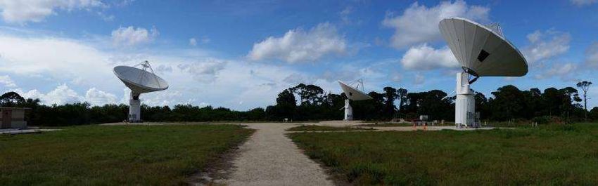
PROCEEDINGS OF SPIE

                   High-Performance Computing in
                   Remote Sensing IV

                   Bormin Huang
                   Sebastian López
                   Zhensen Wu
                   Editors

                   22–23 September 2014
                   Amsterdam, Netherlands

                   Sponsored by
                   SPIE

                   Cooperating Organisations
                   European Association of Remote Sensing Companies (Belgium)
                   Remote Sensing and Photogrammetry Society (United Kingdom)
                   European Optical Society
                   CENSIS—Innovation Centre for Sensor & Imaging Systems
                   EUFAR—European Facility for Airborne Research
                   EARSeL—European Association of Remote Sensing Laboratories
                   TNO
                   ESA

                   Published by
                   SPIE

                                                                                                                                    Volume 9247

                                                                 Proceedings of SPIE 0277-786X, V. 9247
                               SPIE is an international society advancing an interdisciplinary approach to the science and application of light.

                              High-Performance Computing in Remote Sensing IV, edited by Bormin Huang, Sebastian López, Zhensen Wu,
                                Proc. of SPIE Vol. 9247, 924701 · © 2014 SPIE · CCC code: 0277-786X/14/$18 · doi: 10.1117/12.2177904

                                                                         Proc. of SPIE Vol. 9247 924701-1
Downloaded From: https://www.spiedigitallibrary.org/conference-proceedings-of-spie on 19 Aug 2021
Terms of Use: https://www.spiedigitallibrary.org/terms-of-use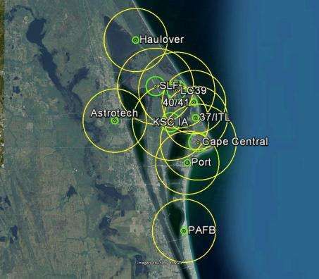
The papers included in this volume were part of the technical conference cited on the cover and
title page. Papers were selected and subject to review by the editors and conference program
committee. Some conference presentations may not be available for publication. The papers
published in these proceedings reflect the work and thoughts of the authors and are published
herein as submitted. The publisher is not responsible for the validity of the information or for any
outcomes resulting from reliance thereon.
Please use the following format to cite material from this book:
Author(s), "Title of Paper," in High-Performance Computing in Remote Sensing IV, edited by
Bormin Huang, Sebastian López, Zhensen Wu, Proceedings of SPIE Vol. 9247 (SPIE, Bellingham, WA,
2014) Article CID Number.
ISSN: 0277-786X
ISBN: 9781628413106
Published by
SPIE
P.O. Box 10, Bellingham, Washington 98227-0010 USA
Telephone +1 360 676 3290 (Pacific Time)· Fax +1 360 647 1445
SPIE.org
Copyright © 2014, Society of Photo-Optical Instrumentation Engineers.
Copying of material in this book for internal or personal use, or for the internal or personal use of
specific clients, beyond the fair use provisions granted by the U.S. Copyright Law is authorized by
SPIE subject to payment of copying fees. The Transactional Reporting Service base fee for this
volume is $18.00 per article (or portion thereof), which should be paid directly to the Copyright
Clearance Center (CCC), 222 Rosewood Drive, Danvers, MA 01923. Payment may also be made
electronically through CCC Online at copyright.com. Other copying for republication, resale,
advertising or promotion, or any form of systematic or multiple reproduction of any material in this
book is prohibited except with permission in writing from the publisher. The CCC fee code is
0277-786X/14/$18.00.
Printed in the United States of America.
Publication of record for individual papers is online in the SPIE Digital Library.
SPIEDigitalLibrary.org
Paper Numbering: Proceedings of SPIE follow an e-First publication model, with papers published
first online and then in print and on CD-ROM. Papers are published as they are submitted and
meet publication criteria. A unique, consistent, permanent citation identifier (CID) number is
assigned to each article at the time of the first publication. Utilization of CIDs allows articles to be
fully citable as soon as they are published online, and connects the same identifier to all online,
print, and electronic versions of the publication. SPIE uses a six-digit CID article numbering system
in which:
The first four digits correspond to the SPIE volume number.
The last two digits indicate publication order within the volume using a Base 36 numbering
system employing both numerals and letters. These two-number sets start with 00, 01, 02, 03, 04,
05, 06, 07, 08, 09, 0A, 0B … 0Z, followed by 10-1Z, 20-2Z, etc.
The CID Number appears on each page of the manuscript. The complete citation is used on the
first page, and an abbreviated version on subsequent pages. Numbers in the index correspond to
the last two digits of the six-digit CID Number.
Proc. of SPIE Vol. 9247 924701-2
Downloaded From: https://www.spiedigitallibrary.org/conference-proceedings-of-spie on 19 Aug 2021
Terms of Use: https://www.spiedigitallibrary.org/terms-of-use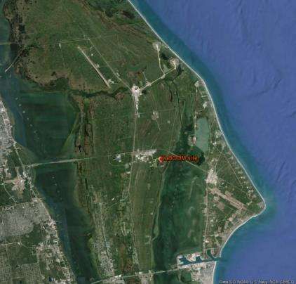
Contents

                                  v      Authors

                                 vii     Conference Committee

                                  ix     Remote sensing at the NASA Kennedy Space Center and the Eastern Range: a
                                         perspective from the ground up (Plenary Paper) [9241-100]

                      SESSION 1          HIGH-PERFORMANCE COMPUTING IN REMOTE SENSING I

                          9247 02        Parallel random selection and projection for hyperspectral image analysis [9247-1]

                          9247 03        FPGA-based architecture for hyperspectral endmember extraction [9247-2]

                          9247 04        Intel Many Integrated Core (MIC) architecture optimization strategies for a memory-bound
                                         Weather Research and Forecasting (WRF) Goddard microphysics scheme [9247-3]

                          9247 05        FPGA implementation of the hyperspectral Lossy Compression for Exomars (LCE) algorithm
                                         (Best Student Paper Award) [9247-4]

                          9247 06        EM scattering from a 2D target above a 1D sea surface using GPU based FDTD [9247-5]

                      SESSION 2          HIGH-PERFORMANCE COMPUTING IN REMOTE SENSING II

                          9247 07        Hybrid DWT-DCT-Hash function based digital image watermarking for copyright protection
                                         and content authentication of DubaiSat-2 images [9247-6]

                          9247 08        Building high-performance system for processing a daily large volume of Chinese satellites
                                         imagery [9247-7]

                          9247 09        Implementation of 5-layer thermal diffusion scheme in weather research and forecasting
                                         model with Intel Many Integrated Cores [9247-8]

                         9247 0A         A composite algorithm for variable size object tracking for high performance FPGA-based
                                         on-board vision systems [9247-9]

                      SESSION 3          HIGH-PERFORMANCE COMPUTING IN REMOTE SENSING III

                         9247 0C         Initial results on computational performance of Intel Many Integrated Core (MIC)
                                         architecture: implementation of the Weather and Research Forecasting (WRF) Purdue-Lin
                                         microphysics scheme [9247-11]

                         9247 0D         GPU efficient SAR image despeckling using mixed norms [9247-12]

                                                                                                                                   iii

                                                                         Proc. of SPIE Vol. 9247 924701-3
Downloaded From: https://www.spiedigitallibrary.org/conference-proceedings-of-spie on 19 Aug 2021
Terms of Use: https://www.spiedigitallibrary.org/terms-of-use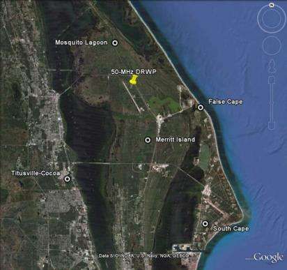
9247 0E        Acceleration of the partitioned predictive vector quantization lossless compression method
                                         with Intel MIC [9247-14]

                          9247 0F        Fast motion detection in coded video streams for a large-scale remote video sensor
                                         system [9247-15]

                      SESSION 4          HIGH-PERFORMANCE COMPUTING IN REMOTE SENSING IV

                         9247 0G         Fast computational method of beam scattering from sea surface [9247-16]

                         9247 0H         A novel highly parallel algorithm for linearly unmixing hyperspectral images [9247-17]

                          9247 0I        The backscattering characteristics and accelerated arithmetic for complex rough target in
                                         THz and laser bands [9247-18]

                          9247 0J        Application of Intel Many Integrated Core (MIC) architecture to the Yonsei University
                                         planetary boundary layer scheme in Weather Research and Forecasting model [9247-19]

                         9247 0K         Efficient parallel implementation of polarimetric synthetic aperture radar data processing
                                         [9247-20]

                      SESSION 5          HIGH-PERFORMANCE COMPUTING IN REMOTE SENSING V

                        9247 0M          Optimizing zonal advection of the Advanced Research WRF (ARW) dynamics for Intel MIC
                                         [9247-22]

                         9247 0O         GPU-based calculation of scattering characteristics of space target in the visible spectrum
                                         [9247-24]

                         9247 0P         GPU-based rectification of high-resolution remote sensing stereo images [9247-25]

                iv

                                                                         Proc. of SPIE Vol. 9247 924701-4
Downloaded From: https://www.spiedigitallibrary.org/conference-proceedings-of-spie on 19 Aug 2021
Terms of Use: https://www.spiedigitallibrary.org/terms-of-use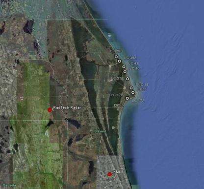
Authors

                              Numbers in the index correspond to the last two digits of the six-digit citation identifier (CID) article
                              numbering system used in Proceedings of SPIE. The first four digits reflect the volume number. Base 36
                              numbering is employed for the last two digits and indicates the order of articles within the volume.
                              Numbers start with 00, 01, 02, 03, 04, 05, 06, 07, 08, 09, 0A, 0B...0Z, followed by 10-1Z, 20-2Z, etc.

                              Al-Mansoori, Saeed, 07                                          Song, Zhan, 0O
                              Alpatov, Boris, 0A                                              Strotov, Valery, 0A
                              Bai, Lu, 0O                                                     Su, Xiang, 0G
                              Barbré, Robert E., Jr., ix                                      Véstias, Mário, 03
                              Callico, Gustavo M., 05, 0H                                     Wang, Qi, 08
                              Cao, YunHua, 0O                                                 Wei, Shih-Chieh, 0E
                              Cho, Hyung-Joon, 0F                                             Wu, Zhensen, 0G, 0I, 0O
                              D’Addario, Larry, ix                                            Xin, Yubin, 08
                              Decker, Ryan K., ix                                             Yang, Pengju, 06
                              Deng, Huawu, 08                                                 Žalik, Borut, 0P
                              Du, Qian, 02                                                    Zhang, Xiaoxiao, 0G
                              García, A., 05
                              Geldzahler, Barry, ix
                              Guerra, Raúl, 0H
                              Guo, Lixin, 06
                              Guo, Xing, 0I, 0O
                              Huang, Allen H.-L., 04, 09, 0C, 0J, 0M
                              Huang, Bormin, 04, 09, 0C, 0E, 0J, 0M
                              Huang, Melin, 09, 0J
                              Huang, Shicun, 08
                              Huddleston, Lisa L., ix
                              Jia, Chungang, 06
                              Kim, Seung-Hwan, 0F
                              Kim, Yong-Sung, 0F
                              Korepanov, Semen, 0A
                              Kunhu, Alavi, 07
                              Li, Xiaochao, 02
                              López, Jose Fco., 05, 0H
                              López, Sebastián, 05, 0H
                              Lukač, Niko, 0P
                              Marpu, Prashanth R., 0K
                              Martinez, Sergio S., 0K
                              Mielikainen, Jarno, 04, 0C, 0M
                              Miller, Michael J., ix
                              Morabito, David D., ix
                              Morgan, Jennifer G., ix
                              Mou, Yuan, 0I
                              Nar, Fatih, 0D
                              Nascimento, José M. P., 03
                              Özcan, Caner, 0D
                              Pan, Zhiqiang, 08
                              Park, Gyu-Hee, 0F
                              Plaza, Antonio J., 0K
                              Roeder, William P., ix
                              Rosário, João, 03
                              Santos, L., 05
                              Sarmiento, Roberto, 05, 0H
                              Seibert, Marc A., ix
                              Şen, Baha, 0D

                                                                                                                                          v

                                                                         Proc. of SPIE Vol. 9247 924701-5
Downloaded From: https://www.spiedigitallibrary.org/conference-proceedings-of-spie on 19 Aug 2021
Terms of Use: https://www.spiedigitallibrary.org/terms-of-use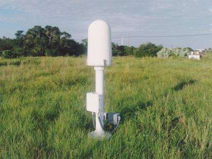
Proc. of SPIE Vol. 9247 924701-6
Downloaded From: https://www.spiedigitallibrary.org/conference-proceedings-of-spie on 19 Aug 2021
Terms of Use: https://www.spiedigitallibrary.org/terms-of-use
Conference Committee

                               Symposium Chair
                                                Charles R. Bostater Jr., Florida Institute of Technology (United States)

                               Symposium Co-chairs
                                                Ulrich Michel, University of Education Heidelberg (Germany)
                                                Bart Snijders, TNO (Netherlands)

                               Conference Chairs
                                                Bormin Huang, University of Wisconsin-Madison (United States)
                                                Sebastian López, Universidad de Las Palmas de Gran Canaria (Spain)
                                                Zhensen Wu, Xidian University (China)

                               Conference Program Committee
                                                Saeed H. Al-Mansoori, Emirates Institution for Advanced Science and
                                                  Technology (United Arab Emirates)
                                                Philip E. Ardanuy, Raytheon Intelligence & Information Systems
                                                  (United States)
                                                Chein-I Chang, University of Maryland, Baltimore County
                                                  (United States)
                                                Yang-Lang Chang, National Taipei University of Technology (Taiwan)
                                                David J. Crain, GeoMetWatch Corporation (United States)
                                                Qian Du, Mississippi State University (United States)
                                                Mitch Goldberg, National Environmental Satellite, Data, and
                                                  Information Service (United States)
                                                Carlos Gonzalez, Universidad Complutense de Madrid (Spain)
                                                Lixin Guo, Xidian University (China)
                                                HungLung Allen Huang, University of Wisconsin-Madison
                                                  (United States)
                                                Tung-Ju Hsieh, National Taipei University of Technology (Taiwan)
                                                Dieter Just, European Organisation for the Exploitation of
                                                  Meteorological Satellites (Germany)
                                                Tsengdar J. Lee, NASA Headquarters (United States)
                                                Francesco Leporati, Università degli Studi di Pavia (Italy)
                                                Prashanth Reddy Marpu, Masdar Institute of Science & Technology
                                                  (United Arab Emirates)
                                                Jarno Mielikainen, University of Wisconsin-Madison (United States)
                                                J. Montgomery, Georgetown University (United States)
                                                Jose M. P. Nascimento, Instituto de Telecomunicações (Portugal)
                                                Abel Paz, Universidad de Extremadura (Spain)

                                                                                                                           vii

                                                                         Proc. of SPIE Vol. 9247 924701-7
Downloaded From: https://www.spiedigitallibrary.org/conference-proceedings-of-spie on 19 Aug 2021
Terms of Use: https://www.spiedigitallibrary.org/terms-of-use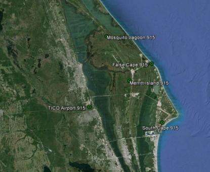
Antonio J. Plaza, Universidad de Extremadura (Spain)
                                                Jeffery J. Puschell, Raytheon Space & Airborne Systems
                                                  (United States)
                                                Shen-En Qian, Canadian Space Agency (Canada)
                                                Stefan A. Robila, Montclair State University (United States)
                                                Joan Serra-Sagrista, Universitat Autònoma de Barcelona (Spain)
                                                Yuliya Tarabalka, INRIA Sophia Antipolis - Méditerranée (France)
                                                Carole Thiebaut, Centre National d'Études Spatiales (France)
                                                Tanya Vladimirova, University of Leicester (United Kingdom)
                                                Shih-Chieh Wei, Tamkang University (Taiwan)
                                                Jiaji Wu, Xidian University (China)
                                                Ye Zhang, Harbin Institute of Technology (China)

                               Session Chairs
                                         1      High-Performance Computing in Remote Sensing I
                                                Bormin Huang, University of Wisconsin-Madison (United States)

                                         2      High-Performance Computing in Remote Sensing II
                                                Sebastian López, Universidad de Las Palmas de Gran Canaria (Spain)

                                         3      High-Performance Computing in Remote Sensing III
                                                Zhensen Wu, Xidian University (China)

                                         4      High-Performance Computing in Remote Sensing IV
                                                Qian Du, Mississippi State University (United States)

                                         5      High-Performance Computing in Remote Sensing V
                                                Saeed H. Al-Mansoori, Emirates Institution for Advanced Science and
                                                  Technology (United Arab Emirates)

                viii

                                                                         Proc. of SPIE Vol. 9247 924701-8
Downloaded From: https://www.spiedigitallibrary.org/conference-proceedings-of-spie on 19 Aug 2021
Terms of Use: https://www.spiedigitallibrary.org/terms-of-use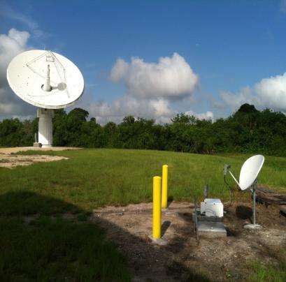
Plenary Paper

                    Remote sensing at the NASA Kennedy Space Center and the Eastern
                                 Range: a perspective from the ground up
                                                       Lisa L. Huddlestona*, William P. Roederb,
                                               David D. Morabitoc, Larry D'Addarioc, Jennifer G. Morgana,
                                                        Robert E. Barbré, Jr.d, Ryan K. Deckere,
                                                 Barry Geldzahlerf, Marc A. Seiberta, Michael J. Millera
                                  a
                                 National Aeronautics and Space Administration, Kennedy Space Center, FL,
                                            b
                                              United States Air Force, Patrick Air Force Base, FL,
                    c
                      National Aeronautics and Space Administration, Jet Propulsion Laboratory, California Institute of
                                                                 Technology
                           d
                             National Aeronautics and Space Administration, Marshall Space Flight Center, Jacobs
                             e
                              National Aeronautics and Space Administration, Marshall Space Flight Center, AL
                                     f
                                      National Aeronautics and Space Administration, Headquarters, DC
                                                                                  ABSTRACT

                This paper provides an overview of ground based operational remote sensing activities that enable a broad range of
                missions at the Eastern Range (ER), which includes the National Aeronautics and Space Administration (NASA)
                Kennedy Space Center (KSC) and U.S. Air Force Cape Canaveral Air Force Station (CCAFS).
                Many types of sensors are in use by KSC and across the ER. We examine remote sensors for winds, lightning and
                electric fields, precipitation and storm hazards. These sensors provide data that are used in real-time to evaluate launch
                commit criteria during space launches, major ground processing operations in preparation for space launches, issuing
                weather warnings/watches/advisories to protect over 25,000 people and facilities worth over $20 billion, and routine
                weather forecasts. The data from these sensors are archived to focus NASA launch vehicle design studies, to develop
                forecast techniques, and for incident investigation. The wind sensors include the 50-MHz and 915-MHz Doppler Radar
                Wind Profilers (DRWP) and the Doppler capability of the weather surveillance radars. The atmospheric electricity
                sensors include lightning aloft detectors, cloud-to-ground lightning detectors, and surface electric field mills. The
                precipitation and storm hazards sensors include weather surveillance radars.
                Next, we discuss a new type of remote sensor that may lead to better tracking of near-Earth asteroids versus current
                capabilities. The Ka Band Objects Observation and Monitoring (KaBOOM) is a phased array of three 12 meter (m)
                antennas being built as a technology demonstration for a future radar system that could be used to track deep-space
                objects such as asteroids. Transmissions in the Ka band allow for wider bandwidth than at lower frequencies, but the
                signals are also far more susceptible to de-correlation from turbulence in the troposphere, as well as attenuation due to
                water vapor, which is plentiful in the Central Florida atmosphere. If successful, KaBOOM will have served as the
                pathfinder for a larger and more capable instrument that will enable tracking 15 m asteroids up to 72 million kilometers
                (km) away, about half the distance to the Sun and five times further than we can track today.
                Finally, we explore the use of Site Test Interferometers (STI) as atmospheric sensors. The STI antennas continually
                observe signals emitted by geostationary satellites and produce measurements of the phase difference between the
                received signals. STIs are usually located near existing or candidate antenna array sites to statistically characterize
                atmospheric phase delay fluctuation effects for the site. An STI measures the fluctuations in the difference of
                atmospheric delay from an extraterrestrial source to two or more points on the Earth. There is a three-element STI
                located at the KaBOOM site at KSC.
                *
                    Corresponding author: lisa.l.huddleston@nasa.gov; phone 1 321 861-4952; fax 1 321 861-7907

                                             Sensors, Systems, and Next-Generation Satellites XVIII, edited by Roland Meynart,
                                            Steven P. Neeck, Haruhisa Shimoda, Proc. of SPIE Vol. 9241, 924102 · © 2014 SPIE          ix
                                                         CCC code: 0277-786X/14/$18 · doi: 10.1117/12.2085784

                                                                         Proc. of SPIE Vol. 9247
                                                                                            9241 924701-9
                                                                                                 924102-1
Downloaded From: https://www.spiedigitallibrary.org/conference-proceedings-of-spie on 19 Aug 2021
Terms of Use: https://www.spiedigitallibrary.org/terms-of-use
Keywords: Remote sensing, Eastern Range (ER), Kennedy Space Center (KSC), Cape Canaveral Air Force Station
(CCAFS) weather, radar, lightning sensors, Doppler Radar Wind Profilers (DRWPs), antenna arrays, atmospheric
fluctuations, coherent uplink, phased arrays, adaptive optics, site test interferometers (STIs)
1. INTRODUCTION
Remote sensing has become a common term in atmospheric and environmental discussions. The vast majority of the
references deal with data produced by space based or "satellite remote sensing" instruments. There is however a broad
range of remote sensing applications that are ground based. A number of these applications are currently in use at the
Eastern Range (ER, Appendix A contains an acronym list) which includes Kennedy Space Center (KSC) and Cape
Canaveral Air Force Station (CCAFS) in Florida (FL) to support a broad range of National Aeronautics and Space
Administration (NASA), United States Air Force (USAF) and commercial space launch missions. This paper describes
the vital role that ground based remote sensing plays in launch operations, personnel safety, resource protection, and
historical databases for mission planning and forecast improvement; in deep space investigations; and in research to
measure the effects of turbulence in the atmosphere on space communication, navigation and radar signals.
2. WEATHER AND LAUNCH OPERATIONS
Comprehensive weather services to the United States of America's space program at the ER is provided by the USAF's
45th Weather Squadron (45WS)1. To provide these services, the ER and 45WS use extensive networks of ground-based
instrumentation to ensure successful launch operations and to aid in vehicle design. These networks comprise the most
unique and dense suite of weather sensors found in operational meteorology today. Lightning detection systems,
specifically the Launch Pad Lightning Warning System (LPLWS), the Four Dimensional Lightning Surveillance System
(4DLSS), and the National Lightning Detection Network (NLDN), are used to detect lightning and assess the Lightning
Launch Commit Criteria (LCC). The C-Band Weather Radar assists in applications that include high precision lightning
forecasting, evaluating lightning LCC, stringent convective wind prediction, severe weather warnings, hail detection,
heavy rain advisories, and warning of local tropical system threats. The Doppler Radar Wind Profiler (DRWP) system
provides wind profiles used to evaluate loads on both day-of-launch and during vehicle design assessments.
Weather is the leading cause for launch scrubs and delays and has a large impact on many aspects of space launch
activities. These include active launch operations, ground processing operations in preparation for launch, post-launch
operations, various special missions, routine 24/7 weather watch and warning responsibilities for personnel safety,
resource protection and mission planning. During launch countdowns, the 45WS forecasts and evaluates the Lightning
LCC, Range LCC, and User LCC2. [2] The Lightning LCC are a set of complex rules used to avoid natural and rocket
triggered lightning3,4,5. The Range LCC include boundary layer profiles of wind, temperature and moisture that are
primarily used for predicting transport and dispersion of atmospheric constituents. This is especially important in the
event of an explosion or other major malfunction where toxic chemicals are released into the atmosphere. Many
atmospheric phenomena generate and/or store electrical charge that is insufficient to cause natural lightning. However,
when a large rocket flies near those areas of electric charge, the long conductive exhaust plume and length of the metal
rocket can amplify the associated electric fields by a factor of over 100. If the amplified electric field exceeds the
breakdown voltage of the air, a rocket triggered lightning occurs. While the lightning can damage the rocket itself, or
more likely the onboard electronics, the greatest concern is the lightning may damage the flight termination system. This
would stop the ability of the flight controllers from being able to destroy the rocket if it goes too far off course. The User
LCC are limits for various weather categories such as near surface winds so the rocket can safely clear the launch tower,
temperature for mechanical integrity of the rocket, and precipitation to avoid damaging the rocket while in-flight.
Requirements also exist for upper level winds to avoid over stressing the space launch vehicle as it counter-steers
through the actual winds versus the planned winds to stay on the correct trajectory and achieve the desired orbit. The
User LCC varies between launch vehicle programs and different configurations of vehicles in the same program6.
The 45WS is responsible for the weather safety of over 25,000 personnel and resource protection for over $20 billion of
facilities, not including the payloads and space launch vehicles. Each year, the remote sensing capabilities at KSC
facilitate the issuance of over 2,500 weather warnings, watches, and advisories. These include warnings for tornadoes,
large hail, strong winds, and imminent or occurring lightning; watches for convective winds, steady state winds,
developing lightning, and heavy rain; and advisories for temperature. Over 5,000 ground processing operations are
x
Proc.
Proc.of
ofSPIE
SPIEVol.
Vol.9247
9241 924701-10
924102-2
Downloaded From: https://www.spiedigitallibrary.org/conference-proceedings-of-spie on 19 Aug 2021
Terms of Use: https://www.spiedigitallibrary.org/terms-of-useperformed annually in preparation for space launches7. Major ground processing operations include vehicle rollouts to
the launch pads, stacking and destacking rocket segments, transporting and mounting and demounting payloads, and
large crane operations. Crane lifts can be very wind sensitive, especially when lifting fueled solid rocket boosters, multi-
billion dollar payloads, or multi-million dollar rocket segments. Minor operations can be as simple as performing
corrosion maintenance on the launch pads. Many of these processing operations are conducted outside and must be
curtailed under certain weather conditions. Some processing operations have restrictive weather limits that can result in
weeks of delay6.
The hazards of lightning, both natural and triggered, are well known and include direct and indirect effects. Direct
effects include heating, pitting or melt-through of conducting materials, puncturing or splintering of nonmetallic
surfaces, burning holes in the skin, the welding or fusing of hinges and bearings; damage to antennas and/or lights; and,
rarely, explosions due to the ignition of fuel vapors8. Indirect effects include any momentary upsets or permanent
damage caused by the transient voltages and currents that are induced by direct or nearby discharges8. For most
spacecraft, the penalties in added cost and weight of hardening against these hazards are too great, so the only option is
avoidance9. Lightning is also a significant weather safety hazard, being the third leading source of storm deaths in the
United States10.[10] Lightning advisories are issued for 10 areas, consisting of circles with a 9.26 kilometer (km, 5
nautical mile (NM)) or 11.11 km (6 NM) radii safety buffer centered on operationally significant sites: seven areas with
considerable overlap on CCAFS/KSC, one with little overlap on KSC, one at Patrick Air Force Base (AFB), and one for
a satellite processing facility at Titusville (Figure 1). A Phase-1 Lightning Watch is issued for one or more of these areas
if lightning is expected with a desired lead-time of 30 min. A Phase-II Lightning Warning is issued when lightning is
imminent or occurring in one or more of these areas. One of the greatest challenges is the ability to reliably cancel these
lightning advisories more quickly to allow outdoor work to resume, while still maintaining safety6. As one might expect
with all the thunderstorm activity, convective wind warnings are also important, with an average of over 175 warnings
each year. The convective wind warnings have unusually precise requirements and large desired lead-times6.
In addition to those items already discussed, four other aspects of launch are evaluated for weather concerns. The first
launch aspect is 'LOADS', which refers to the aerodynamic loading on the rocket as it counter-steers against the upper-
level winds to stay on the desired trajectory. If the actual winds differ too much from the assessed winds, the rocket
could destroy itself. The LOADS community of aeronautical engineers continually analyzes the observed winds and
assesses their impact to the vehicle to prevent this from happening. There is an extensive archive of vertically complete
wind profiles generated by the Marshall Space Flight Center (MSFC) Natural Environments (NE) group using the
DRWP network at the ER. This archive is used to mitigate the multiple shortcomings of utilizing balloon-based
measurements for space vehicle loads and trajectory assessments. Launching vehicles into space requires accurately
characterizing the wind environment that the vehicle will experience through ascent. Specific effects of the ascent winds
on launch vehicles depend on the characteristics of the vehicle components and the magnitude of the wind acting on
those components11. Range Safety evaluates the second, third, and fourth aspects of launch: 'Toxic Dispersion', 'BLAST',
and 'Debris'12. Toxic dispersion from nominal and catastrophic launches is analyzed to ensure that they will not exceed
allowable toxic exposure limits for the on-base and nearby civilian populations. 'BLAST' analyzes the likelihood of
windows in nearby towns being broken and causing a safety hazard if a rocket explodes13. The 'Debris' program
considers if parts of the rocket from a nominal or catastrophic launch would fall outside of the allowed impact areas6.
xi
Proc.
Proc. of
of SPIE
SPIE Vol.
Vol. 9247
9241 924701-11
924102-3
Downloaded From: https://www.spiedigitallibrary.org/conference-proceedings-of-spie on 19 Aug 2021
Terms of Use: https://www.spiedigitallibrary.org/terms-of-usePAFB
Central
Figure 1. The 10 lightning warning circles used by 45 WS.
2.1 Eastern Range Weather Systems
The ER possesses one of the world’s most dense operational networks of weather instrumentation14. This
instrumentation is used to minimize the impact of weather while ensuring the safe processing and launching of space
vehicles. Some, but not all, of these weather instruments use remote sensing. For example, the ER uses a network of 28
weather towers that measures wind, temperature, and moisture in the first few hundred feet of the atmosphere. However,
this paper will focus only on the ER weather instruments that use ground-based remote sensing. These include lightning
detection systems, the DRWPs, and the weather radar. The ground-based remote sensing weather sensors and the data
they provide are listed in Table 1.
Table 1. Ground-based remote sensing weather sensors at the Eastern Range
Sensor Data Provided Main Operational Applications
Four Dimensional Lightning Cloud-to-Ground Lightning Assess risk of induced current damage,
Surveillance System - return strokes (not flashes) Lightning warnings (approaching storms),
(4DLSS) - latitude, longitude Evaluate Lightning LCC
- date, time
- peak current, polarity
Lightning aloft Lightning warnings
- step leaders Evaluate Lightning LCC
- latitude, longitude, height
- date, time
Launch Pad Lightning Surface electric field Evaluate Lightning LCC
Warning System (LPLWS)
Weather Radar Reflectivity Lightning prediction, Lightning LCC
evaluation, severe weather warnings,
precipitation detection, general weather
support
Doppler velocity Severe weather warnings
Spectral width None
Differential reflectivity Possibly lightning onset and hydrometeor
identification for lightning cessation, hail
xii
Proc.
Proc.of
ofSPIE
SPIEVol.
Vol.9247
9241 924701-12
924102-4
Downloaded From: https://www.spiedigitallibrary.org/conference-proceedings-of-spie on 19 Aug 2021
Terms of Use: https://www.spiedigitallibrary.org/terms-of-useSensor Data Provided Main Operational Applications
warnings, tornado detection, etc.
Phase differential Possibly hydrometeor identification for
lightning cessation, hail, tornado, etc.
Correlation coefficient Possibly hydrometeor identification for
lightning cessation, hail, tornado, etc.
50-MHz Doppler Radar Vertical wind profiles Evaluate LOADS
Wind Profiler (50DRWP) - wind speed/direction
vs. height (base-top)
915-MHz Doppler Radar Vertical wind profiles Evaluate toxic dispersion, BLAST, and
Wind Profiler (915DRWP) - wind speed/direction Debris
vs. height (base-top)
2.2 Lightning Detection Systems
The ER is well instrumented with respect to lightning detection sensors. These sensors exist not only because lightning
can adversely affect the vehicle and corresponding operations, but also because central Florida is the area of highest
lightning activity in the United States (U.S.)15 The ER utilizes the Launch Pad Lightning Warning System (LPLWS), the
Four Dimensional Lightning Surveillance System (4DLSS), and the National Lightning Detection Network (NLDN) to
detect lightning.
The LPLWS consists of a network of 31 field mills distributed in and around the launch and operations areas of CCAFS
and KSC. The location of the 31 mills is shown in Figure 2 and picture of one of the field mills is shown in Figure 3 The
network measures the electric field at the surface, which is used to infer electric fields aloft - a key to evaluating the
danger of triggered lightning during launch operations14. In the Lightning LCC, field mills can be used to either avoid
launch under hazardous conditions, or to allow safe launch that otherwise would have been falsely identified as
hazardous. The one-minute average of the electric field mill network may not exceed -1 or +1 kilovolts per meter (kV/m)
within 9.26 km (5 NM) of the launch pad or the lightning flash at any time within 15 minutes prior to launch. This field
mill criteria becomes -1.5 or +1.5 kV/m if there are no clouds within 18.52 km (10 NM) of the flight path except those
that are transparent3,4,5.
The 4DLSS detects both cloud-to-ground return strokes and lightning aloft16,17.[16] The 4DLSS was a major upgrade to
the previous Lightning Detection and Ranging (LDAR) system that detected lightning aloft and the Cloud to Ground
Lightning Surveillance System (CGLSS)16,17. The cloud-to-ground lightning part of the network consists of a network of
six low frequency (LF) magnetic direction-finding and time-of-arrival (IMPACT) sensors located in and around the
launch and operations areas of CCAFS and KSC (Figure 4). A picture of one of these sensors is shown in Figure 5. They
are deployed on relatively short baselines and operate at low gain to ensure the requirements for high location accuracy
and detection efficiency of cloud-to-ground strikes are satisfied14. This part of 4DLSS provides the latitude, longitude,
time, peak current, and polarity for each return stroke within a lightning flash. The lightning aloft part of 4DLSS
consists of a network of nine receiver sites which detect inter-cloud, intra-cloud and cloud-to-ground lightning.
Lightning aloft is geolocated using VHF time-of-arrival between multiple pairs of sensors14. The locations of the
sensors is shown in Figure 6 with an example of one of the sensors is at Figure 7. The time-of-arrival differences
between multiple pairs of sensors is used to locate the three dimensional (3-D) structure of the lightning. The 4DLSS is
being replaced with a new system to overcome sustainment problems of the old sensors and take advantage of
improvements in lightning detection technology. The new system is the Mesoscale Eastern Range Lightning Network
(MERLiN).
The 45WS also has a direct link to the NLDN, which is a network of about 130 cloud-to-ground sensors across the
contiguous U.S18. The NLDN is also has a relatively new low detection efficiency capability for detecting lightning aloft.
This NLDN link is used as a back-up to the cloud-to-ground portion of 4DLSS, for cloud-to-ground lightning detection
capability for occasional missions beyond the range of 4DLSS, and as supplemental quality control of 4DLSS cloud-to-
ground lightning.
xiii
Proc.
Proc.of
ofSPIE
SPIEVol.
Vol.9247
9241 924701-13
924102-5
Downloaded From: https://www.spiedigitallibrary.org/conference-proceedings-of-spie on 19 Aug 2021
Terms of Use: https://www.spiedigitallibrary.org/terms-of-useFigure 2. Field mill sensor locations. Figure 3. A field mill sensor.
.,
:l'
Figure 4. CGLSS sensor locations. Figure 5. A CGLSS sensor.
Figure 6. An LDAR-II sensor. Figure 7. LDAR-II sensor locations.
xiv
Proc.
Proc.of
ofSPIE
SPIEVol.
Vol.9247
9241 924701-14
924102-6
Downloaded From: https://www.spiedigitallibrary.org/conference-proceedings-of-spie on 19 Aug 2021
Terms of Use: https://www.spiedigitallibrary.org/terms-of-use2.3 Weather Radar
One of the most important weather sensors is the C-band (5 cm) Radtec Titan Doppler Radar with 4.3 m diameter
antenna and 250 kW average transmitted power (TDR 43-250) manufactured by Radtec Engineering, Inc19. The space
program on the ER makes use of several atypical applications of weather radar20. These applications include high
precision lightning forecasting, evaluating lightning LCC, stringent convective wind prediction, severe weather
warnings, hail detection, heavy rain advisories, and warning of local tropical system threats20. The location of the 45WS
radar and a picture of the radar are shown in Figure 8 and
Figure 9, respectively.
The TDR 43-250 radar is a dual polarization Doppler weather surveillance radar that detects reflectivity, Doppler
velocity, spectral width, differential reflectivity, phase differential, and correlation coefficient. Reflectivity indicates the
intensity of precipitation, and the shape and motion of thunderstorms that can imply the type and intensity of hazard they
may produce. Reflectivity is especially useful in forecasting the onset of lightning in locally developing
thunderstorms21,22 and in evaluating Lightning LCC. Doppler velocity can detect storm rotation that can indicate severe
weather, especially tornadoes. Differential reflectivity, phase differential, and correlation are new dual polarization
capabilities that should have many new capabilities including lightning formation21,22, lightning cessation, hail detection,
tornado detection23, and eventually Lightning LCC evaluation.
The 45WS also has a direct feed from the Weather Surveillance Radar – 1988 Doppler (WSR-88D radar) at Melbourne,
FL. This radar is part of the Next Generation Weather Radar (NEXRAD) network shared by the Department of Defense
(DoD), National Weather Service (NWS), and the Federal Aviation Administration (FAA). This radar is an S-band (10
cm) dual polarization Doppler weather surveillance radar. This radar serves as a back-up to the Radtec radar and
provides dual wavelength capability in combination with the 45WS radar.
Figure 8. Locations of radars used by 45WS. Figure 9. 45WS C-band weather radar.
2.4 Doppler Radar Wind Profilers
A Doppler Radar Wind Profiler (DRWP) is a radar system designed to detect the Doppler shift of clear-air turbulence in
order to measure vertical profiles of wind. DRWPs work by transmitting radio pulses along two or more beams and
using the Doppler shift of the returned signals from the two vectors to calculate the wind vector, and use different
frequencies and different transmission powers depending on maximum height of wind required. DRWP systems are
remote sensors and the maximum height probed varies with atmospheric conditions and especially latitude24. The MSFC
NE group generates an extensive archive of vertically complete wind profiles using the DRWP network at the ER to
xv
Proc.
Proc.of
ofSPIE
SPIEVol.
Vol.9247
9241 924701-15
924102-7
Downloaded From: https://www.spiedigitallibrary.org/conference-proceedings-of-spie on 19 Aug 2021
Terms of Use: https://www.spiedigitallibrary.org/terms-of-usemitigate the shortcomings of utilizing balloon-based measurements for space vehicle loads and trajectory assessments.
Launching vehicles into space requires accurately characterizing the wind environment the vehicle will experience
during ascent. Specific effects of the ascent winds on launch vehicles depend on the characteristics of the vehicle
components and the magnitude of the wind acting on those components12. The shortfall of balloon measurements of
winds are long sensing time (over 1.5 hours to measure winds from surface to ~30,000 m), downwind drift of the balloon
(up to 280 km downwind or more at ~30,000 m), and pendulum motion of the sensor at the end of the 30 m string
attached to the balloon.
2.4.1 50-MHz DRWP
Every launch passes through the atmosphere. Winds below altitudes of 18 - 20 km (60 - 65 kft) are a major concern for
safety and mission assurance, guidance and steering, and aerodynamic loads. The 50-MHz DRWP is located just east of
the Shuttle Landing Facility at KSC (Figure 10). The former 50-MHz DRWP consisted of an irregular octagon-shaped
antenna field, which spanned 15,600 square meters (m) and consisted of coaxial-collinear elements set 1.5 m above the
ground plane made of copper wire. These elements sent electronic pulses at 49.25 MHz through three beams. One beam
pointed vertically, and two oblique beams pointed 15° off zenith at azimuths of 45° and 135° East from due North
(Figure 11). To measure wind velocities, the 50-MHz DRWP sent radio pulses in the three beam directions sequentially
and measured the return signals that were reflected by temperature and humidity fluctuations in the atmosphere. Bragg
Scattering designates this process, where changes in temperature and humidity with length scales of about half of the
DRWP's wavelength, (~3 m for the 50-MHz DRWP), produce the return signal. A Fast Fourier Transform converted the
signal in the time-domain to the frequency domain (Doppler power spectra) over 256 frequency bins at each range gate.
There were 111 range gates from 2,666-18,616 m every 145 m and profiles were generated every three minutes12.
Figure 10. 50-MHz DRWP location at the ER. Figure 11. A schematic of the DRWP’s beam
configuration12.
Currently this system is being replaced by a new 50-MHz DRWP manufactured by DeTect, Inc. The antenna of the new
system will have a full beam steering (FBS) capability. (NASA will use specific pointing directions, however.) It is of a
scalable design and is primarily soft-fail. The new antenna is comprised of 640 Yagi elements arranged in a thinned
pattern. Each Yagi element transmits at the same power level and the antenna amplitude taper minimizes sidelobes.
This new 50-MHz DRWP, which is based on the NOAA National Profiler Network24 contains a solid state 250 kW
transmitter, solid state programmable phase switching, and permits additional operating modes such as 4-beam and
Velocity Azimuth Display (VAD) modes without modification.
xvi
Proc.
Proc.of
ofSPIE
SPIEVol.
Vol.9247
9241 924701-16
924102-8
Downloaded From: https://www.spiedigitallibrary.org/conference-proceedings-of-spie on 19 Aug 2021
Terms of Use: https://www.spiedigitallibrary.org/terms-of-use2.4.2 915-MHz Boundary Layer DRWP Network
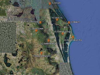
A network of five 915-MHz DRWPs is arranged in a diamond-shaped pattern around the periphery of the ER (Figure
12). The 915-MHz DRWP is smaller than the 50-MHz DRWP due to its antenna structure, and thus one can use more of
them in a given region. Figure 13 shows a picture of one of the 915-MHz DRWPs in the region. The network's
configuration allows for each 915-MHz DRWP to potentially sample a different atmospheric boundary layer regime,
especially in a dynamic environment12. This network was installed to fill the gap from the top of the wind towers to the
lowest gate of the 50-MHz DRWP. Vertical profiles are generated from 120-5,000 m every 100 m and profiles are
generated every fourteen minutes. The system's primary mission objectives are: (1) to collect wind profiles for use by the
Launch Weather Officer to monitor rapidly changing weather conditions, help ensure that launch constraints are
satisfied, and to provide Range Users with timely guidance during the countdown and launch pad operations; (2) to
monitor rapidly changing weather conditions that could affect ground and launch operations by Range Safety and as an
input to the Range Safety models used to predict the transport and diffusion of airborne contaminants released from
ground level spills; and (3) to provide forecasters with a continuous description of the intermediate levels of the
atmosphere for routine weather forecasting and the early detection of hazardous conditions25.
\. 9; 5
l
Meritb
l
t !
+
)t
SoatnYC ape -9!5
Figure 12. 915-MHz DRWP locations at the ER. Figure 13. A 915-MHz DRWP at the ER.
3. KA BAND OBJECT OBSERVATION AND MONITORING
3.1 KaBOOM
The weather sensing technologies for processing and launching rockets will be of little use if a piece of orbital debris
destroys a spacecraft in orbit or if a potentially hazardous asteroid or comet is on a collision course with the Earth.
Therefore, NASA has embarked on a path to implement a high power, high resolution radar system to better track and
characterize near-Earth objects (NEOs) and orbital debris. KaBOOM is a phased array of three 12 meter (m) diameter
antennas at KSC. NASA is exploring the use of small diameter antennas as a phased radar array that is both scalable and
extensible to achieve high power, high resolution, high reliability, simultaneous multiple direction operations, low life
cycle cost, and elimination of power density restrictions. Applying this technique of coherent uplink arraying would
produce a more reliable, available, scalable, extensible radar with a lower life cycle cost26.
3.2 Potentially Hazardous Asteroids (PHA’s)
If an object is verified to be on an Earth colliding trajectory, it seems likely that this collision possibility will be known
several years prior to the actual event27. With this lead time, existing technology could be used to mitigate the threat to
the Earth. In the short term, the probability of an Earth impact is low, however, over longer periods of time, the
probability of Earth impact is not negligible. One can view the probability of potential Earth impact events based on
xvii
Proc.
Proc.of
ofSPIE
SPIEVol.
Vol.9247
9241 924701-17
924102-9
Downloaded From: https://www.spiedigitallibrary.org/conference-proceedings-of-spie on 19 Aug 2021
Terms of Use: https://www.spiedigitallibrary.org/terms-of-usecurrently available observations in the Jet Propulsion Laboratory (JPL) Near-Earth Object (NEO) Program Sentry Risk
Table at http://neo.jpl.nasa.gov/risk/.
Potentially Hazardous Asteroids (PHAs) are defined based on the asteroid's potential to make threatening close
approaches to the Earth. Specifically, all asteroids with an Earth Minimum Orbit Intersection Distance (MOID) of 0.05
AU (4,650,000 miles) or less, and asteroids smaller than about 150 m (500 ft) in diameter are not considered PHAs.
There are currently 1487 known PHAs27.
This "potential" to make close Earth approaches does not mean a PHA will impact the Earth. It only means there is a
possibility for such a threat. By monitoring these PHAs using phased array antennas such as those being demonstrated
by KaBOOM, and updating their orbits, we will be able to better predict the close-approach statistics and their Earth-
impact threat27.
Besides 24/7 availability for planetary protection (NEO tracking and characterization), NASA has several other uses for
uplink arraying: improved detection and tracking of small (≤ 1 - 10 cm) orbital debris particles; rapidly available high
power emergency uplink capability for spacecraft emergencies; radio science experiments (tomography of planetary
atmospheres, general relativity tests, mass determinations, occultations, surface scattering, etc.); and beam sailing
propulsion capability26.
3.3 The Demonstration Project
The KaBOOM demonstration consists of a phased array of three 12 m diameter antennas, shown in Figure 14 below. It
is intended to extend prior experiments to higher frequencies, and will eventually operate near 30 GHz. Its main features
are the ability (a) to produce phase-aligned signals at a distant target without external calibration, and (b) to use a
downlink signal (if one is simultaneously present) to measure the effects of tropospheric turbulence along the signal
paths and apply real-time corrections to the uplink signal. The effects of tropospheric turbulence increase in proportion
to signal frequency, as do the effects of errors in the instrumentation28,29, making the KaBOOM demonstration
particularly challenging.
In 2008, uplink arraying demonstrations were carried out by two different groups at JPL, one using two and three of the
Goldstone Deep Space Network (DSN) site's 34 m at 7.2 GHz30 and another using five 1.2 m antennas at 14 GHz31. Both
demonstrations were successful. The systems were stable and the expected change in power at the target with number of
active antennas was observed. (For identical antennas and transmitters, the received power for an N-antenna array is N2
times that of one antenna.) There was no correction for atmospheric turbulence in either case.
In 2010, NASA funded an uplink array demonstration at 8 GHz using three 12 m antennas in Melbourne, FL. That
experiment seemed to show that phase-aligned signals at the target can be achieved without external calibration by using
internal phase-transfer electronics and correcting for measured mechanical differences among the antennas29,32.
Furthermore, it was demonstrated that real-time compensation for tropospheric turbulence may be possible when there is
a strong reference source in the antenna beams, such as a beacon on the target satellite. The atmosphere compensation
was demonstrated not only in clear, relatively dry air, but also during Tropical Depression 16/Tropical Storm Nicole
(Figure 15)32. The present KaBOOM demonstration is using the very same 12 m antennas and some of the electronics
that were used in the Melbourne experiment, although completely new electronics and more precise mechanical
measurements will be needed at 30 GHz.
xviii
Proc. of SPIE Vol. 9247
9241 924701-18
924102-10
Downloaded From: https://www.spiedigitallibrary.org/conference-proceedings-of-spie on 19 Aug 2021
Terms of Use: https://www.spiedigitallibrary.org/terms-of-useFigure 14. KaBOOM antennas at KSC.
Tropical Atlantic - Water Vapor Loop
Figure 15. Tropical Atlantic water vapor loop showing environmental conditions during testing of the real-time atmospheric
fluctuation compensation test in September 2010. Tropical Depression 16, September 29, 2010, 04:45 UTC. Light rain and
substantial irregular water vapor content along pathway.
4. SITE TEST INTERFEROMETERS
4.1 Transition to Higher Frequencies
As NASA progresses into the 21st century, its communications network systems (e.g., Deep Space and Near Earth
Networks) are expected to transition frequencies above 30 GHz. These systems will be required to provide services with
a system availability of higher than 99% (versus the current 90% availability) and gigabit data rates (versus current ~
megabit data rates). However, the atmospheric phase stability (time delay fluctuations) and attenuation of a particular
site must be well characterized.
A Site Test Interferometer (STI) measures the difference in signal delay from a celestial source (typically a geostationary
satellite) to two or more points on the Earth. Variations in that delay difference are primarily due to turbulence in the
troposphere, which creates a difference in the mean refractive indices along the paths33.
xix
Proc. of SPIE Vol. 9247
9241 924701-19
924102-11
Downloaded From: https://www.spiedigitallibrary.org/conference-proceedings-of-spie on 19 Aug 2021
Terms of Use: https://www.spiedigitallibrary.org/terms-of-useAn STI constructed by the JPL and based on a design provided by the Harvard Smithsonian Center for Astrophysics
(CfA) has been installed at KSC. Nearly identical instruments have been deployed by JPL at five additional sites around
the world, and other STIs have been in operation at radio observatories for many years. The KSC STI uses three small
(0.8 m) antennas in a triangular configuration with spacings of 135 to 289 m to receive and process signals from a
commercial geostationary satellite (NIMIQ 5, azimuth 163.8° and elevation 55.6°). The observed turbulence varies with
weather and season, but its effect over ~200 m distance scales is not measurable by ordinary meteorological instruments,
hence the need for a specialized instrument. While the STI is designed to provide a long-term statistical characterization
of the site, it will also help KaBOOM to determine how much its signals are being disrupted by the atmosphere in near-
real-time, and thus provide a measure of how well KaBOOM's atmosphere compensation process is working34.
4.2 Operational Sites
Two STIs have been operating at the NASA DSN site in Goldstone, California for several years33. These instruments
have two and three antennas, respectively, with element separations of ~200 m. Three-element STIs have also been
installed at the Canberra and Madrid DSN sites. The antennas continuously observe signals emitted by geostationary
satellites, and the phase difference of the received signals is measured. During post-processing, long period trends due to
satellite motion and instrumental drift are removed. Fluctuations in the resulting phase delay residuals are dominated by
the troposphere on timescales ranging fromFigure 16. Location of the KaBOOM antennas and STI
instrument at KSC.
26
16
C49
0.8
0,7
0.6
as
e .,
0.3
0.I
a1
0
-
-I:
,
i
WNW!
j
/
I
.
r/
-
Figure 17. Foreground: one of three small antennas
that make up the STI instrument. Background: one of
the larger antennas of the KaBOOM demonstration.
Op.1.
-
- Acg i3
-Sep-13
- Oct-13
- Nov-13
- Dec-13
lan-14
Feb14
Mar-14
Ay-14
May-14
- lun 14
11 13 15 17 19 21 23 25 27 29 31 1 2 3 4 5 6 7 9 10
Day of Month Zenith Delay RMS, ps
K5CBeeeme1 K5C6ese109 2 x5C6eselhe3
Figure 19. Monthly cumulative distribution curves of
Figure 18. Delay RMS in 600-s blocks referenced to zenith delay RMS for the KSC STI (warmer months
zenith for the KSC STI (all three baselines). shown in reddish curves, winter months in bluish/purplish
curves.
.
5. CONCLUSION
Remote sensing in meteorology is normally thought of as being done from satellites. However, ground-based remote
sensing is also important in operational meteorology. As is described, ground-based remote sensing is critical to the
success of America's space program at NASA's Kennedy Space Center and Cape Canaveral Air Force Station in Florida.
In addition, the Ka Band Object Observation and Monitoring project, which is a unique application of remote sensing
being developed to improve capability for tracking space debris and near Earth asteroids will become more important as
future satellites are deployed and greater use is made of Low Earth Orbit (LEO). Site Test Interferometers, which will
allow for scheduling observations to minimize atmospheric degradation on the project's operations is an example of the
emerging ground based technology that will support and enhance future remote sensing capabilities.
xxi
Proc. of SPIE Vol. 9247
9241 924701-21
924102-13
Downloaded From: https://www.spiedigitallibrary.org/conference-proceedings-of-spie on 19 Aug 2021
Terms of Use: https://www.spiedigitallibrary.org/terms-of-useREFERENCES
[1] Boyd, B. F., Madura, J. T., and Adams, M. E., "Meteorological support to the United States Air Force and NASA at
the Eastern Range and Kennedy Space Center," Paper 93-0753, AIAA 31st Aerospace Sciences Meeting and Exhibit,
(January 1993).
[2] Hazen, D. S., Roeder, W. P., Boyd, B. F., Lorens, J. B., and Wilde, T. L., "Weather impact on launch operations at
the Eastern Range and Kennedy Space Center," Preprints, Sixth Conf. on Aviation Weather Systems, Amer. Meteor.
Soc., pp. 270-275. (1995).
[3] Krider, E .P., Koons, H. C., Walterscheid, R. L., Rust, W. D., and Willett, J. C., " Natural and triggered lightning
launch commit criteria (LCC), " Aerospace Report No. TR-99(1413)-1, 15 January 1999.
[4] Krider, E. P., Christian, H. J., Dye, J. E., Koons, H. C., Madura, J. T., Merceret, F. J., Rust, D. L., Walterscheid, R.
L., and Willett, J. C., " Natural and triggered lightning launch commit criteria (LCC)," Conference on Aviation,
Range and Aerospace Meteorology, (2006).
[5] McNamara, T. M., Roeder, W. P., and Merceret, F. J., "The 2009 update to the lightning launch commit criteria, "
14th Conference on Aviation, Range, and Aerospace Meteorology, (2010).
[6] Roeder, W. P., Hajek, D. L., Flinn, F. C., Maul, G. A., and Fitzpatrick, M. E., "Meteorological and oceanic
instrumentation at Spaceport Florida - opportunities for coastal research," 5th Conference on Coastal Atmospheric
and Oceanic Prediction and Processes, (2003).
[7] Boyd, B. F., Roeder, W. P., Lorens, J. B., Hazen, D. S., and Weems, J., "Weather Support to Pre-launch operations
at the Eastern Range and Kennedy Space Center," Preprints 6th Conference on Aviation Weather Systems, pp. 135-
140, (1995).
[8] Walterscheid, R. L., Willett, J. C., Krider, E. P., Gelinas, L. J., Law, G. W., Peng, G. S., Seibold, R. W., Simmons,
F. S. and Zittel, P. F., "Triggered lightning risk assessment for reusable launch vehicles at four regional spaceports, "
Aerospace Report No. ATR-2010(5387)-1, (30 April 2010).
[9] Willett, J.C., Merceret, F. J., Krider, E. P., Dye, J. E., O'Brien, T. P., Rust, W. D., Walterscheid, R. L., Madura, J.
T., and Christian, H. J., "Rationales for the Lightning Flight Commit Criteria," NASA/TM-2010-216291, 236 pp.
(2010).
[10] Roeder, W. P., "Lightning has fallen to third leading source of U.S. storm deaths," 2012 Annual Meeting of the
National Weather Association, (2012).
[11] Barbré, R.E., "Characteristics of the Spliced KSC Doppler Radar Wind Profiler Database". Jacobs ESSSA Group
Analysis Report. ESSSA-FY13-1935.
[12] Boyd, B. F., Harms, D. E., Fitzpatrick, M. E., Stout, R. P., Rosati, P. N., Berlinrut, D. D., Parks, C. R., and
Overbeck, K. B., "Weather Support To Range Safety," Joint Army Navy NASA Air Force Safety & Environmental
Protection Subcommittee, CPIA Pub. 687, Vol. I, pp. 59-69. (1999).
[13] Boyd, B. F., Harms, D. E., Rosati, P. N., Parks, C. R., and Overbeck, K. B., "Weather Support To Range Safety For
Forecasting Atmospheric Sonic Propagation," 9th Conference on Aviation, Range, and Aerospace Meteorology, pp.
432-437. (2000).
[14] Harms, D.E., Boyd, B. F., Flinn, F. C., McNamara, T. M., Madura, J. T., Wilfong, T. L., and Conant, P. R.,
"Weather system upgrades to support space launch at the Eastern Range and Kennedy Space Center." 12th
Symposium on Meteorological Observations and Instrumentation, (2003).
[15] Huffines, G. R. and Orville, R. E., "Lightning ground flash density and thunderstorm duration in the continental
United States: 1989-96," Journal of Applied Meteorology, 38, 1013-1019 (1999).
[16] Roeder, W.P. and Saul, J. M., 2012. "Four Dimensional Lightning Surveillance System: Status and Plans," 22nd
International Lightning Detection Conference, (2012).
[17] Roeder, W. P., "The Four Dimensional Lightning Surveillance System," 21st International Lightning Detection
Conference, (2010).
[18] Cummins, K. L., Cramer, J. A., Biagi, C. J., Krider, E. P., Jerauld, J., Uman, M. A., Rakov, V. A., "The U.S.
National Lightning Detection Network: Post upgrade status, " 2nd conference on Meteorological Applications of
Lightning Data, (2006).
[19] Roeder, W.P., McNamara, T. M., Boyd, B. F., and Merceret, F. J., "The new weather radar for America's space
program in Florida: an overview," 34th Conference on Radar Meteorology, (2009).
[20] Roeder, W.P., T.M. McNamara, T. M., B.F. Boyd, B. F., J.W. Weems, J. W., and S.B. Cocks, S. B., "Unique uses of
weather radar for space launch". 32nd Conference on Radar Meteorology, (2005).
xxii
Proc. of SPIE Vol. 9247
9241 924701-22
924102-14
Downloaded From: https://www.spiedigitallibrary.org/conference-proceedings-of-spie on 19 Aug 2021
Terms of Use: https://www.spiedigitallibrary.org/terms-of-useYou can also read