PUBLIC CONSULTATION DRAFT - PROPOSED EDGAR ROAD AND SWEYNE ROAD CONSERVATION AREA CHARACTER APPRAISAL AND MANAGEMENT PLAN Thanet District Council
←
→
Page content transcription
If your browser does not render page correctly, please read the page content below
PROPOSED EDGAR ROAD AND SWEYNE ROAD
CONSERVATION AREA

CHARACTER APPRAISAL AND MANAGEMENT
PLAN

Thanet District Council

PUBLIC CONSULTATION DRAFT
2

This document has been written for Thanet District Council by:

The Conservation Studio
1 Querns Lane,
Cirencester,
Glos GL7 1RL.

T: 01285 642428
E: info@theconservationstudio.co.uk
W: www.theconservationstudio.co.uk
3

Contents

Executive Summary

PART 1 THE PROPOSED EDGAR ROAD AND SWEYNE ROAD CONSERVATION AREA
– CHARACTER APPRAISAL

Executive Summary

1     Introduction
      1.1    Summary of the special interest of the proposed Edgar Road and Sweyne
             Road Conservation Area
      1.2    The control of conservation areas
      1.3    Community involvement

2     Location and setting
      2.1    Location and context
      2.2    Setting, topography and geology
      2.3    Biodiversity

3     Historical development
      3.1    Archaeology
      3.2    The development of Margate
      3.2    The development of the proposed Edgar Road and Sweyne Road
             Conservation Area
      3.4    Activities

4     Spatial analysis
      4.1    General character and plan form
      4.2    Focal points, focal buildings, views and vistas
      4.3    Boundaries
      4.4    Public realm

5     The buildings of the conservation area
      5.1   Building types and dates
      5.2   Listed buildings
      5.3   Locally listed buildings
      5.4   Positive buildings
      5.5   Building styles, materials and colours

6     The extent of intrusion or damage
      6.1   Key negative features
      6.2   Summary of issues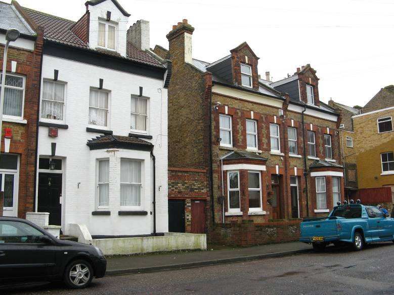
4

PART 2 THE PROPOSED EDGAR ROAD AND SWEYNE ROAD CONSERVATION AREA
- MANAGEMENT PLAN

1     Introduction
      1.1    The purpose of the Management Plan
      1.2    Relevant documents
      1.3    Summary of issues

2     Recommended actions
      2.1  The control of new development
      2.2  The protection of views
      2.3  The public realm
      2.4  The control of car parking and traffic
      2.5  The control of unlisted buildings (Article 4 Directions)
      2.6  Building condition and the role of grant aid
      2.7  The Local list
      2.8  Site specific recommendations
      2.9  Education and guidance
      2.10 Monitoring and review

3     Action Plan

4     Contact details

APPENDICES

Appendix 1   Map 1 Townscape Appraisal Map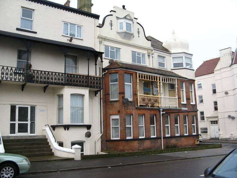
5

EXECUTIVE SUMMARY

Cliftonville in east Margate is a well preserved seaside resort, and most of the original
streets, spaces and buildings remain relatively unaltered. Built to high standards of design
and construction from the 1860s onwards, the buildings provide a fine example of historic
seaside architecture which is compatible in quality to similarly dated seaside developments
elsewhere in England. Against this remarkable survival must be balanced the fact that
today, the Margate Central and Cliftonville West wards are amongst the most deprived
wards in the south east (as defined by the Indices of Deprivation 2007).

In their report following a recent visit to Margate, the Urban Panel of the Commission for
Architecture and Built Environment (CABE) stated that “Cliftonville could, by a different fluke
of social history and demographics, be one of the most desirable parts of the country to live".
For the past few years, the District Council and its partners have been taking a strategic
approach towards the social and economic regeneration of Margate Central and West
Cliftonville, as evidenced by the designation of new conservation areas, the provision of
grant aid, and the provision of new planning policies and guidance. A successful future can
often be secured by keeping and improving that which is best from the past.

Cliftonville has also been identified as important part of the local heritage by officers of the
District Council, by English Heritage (this Appraisal was in the main grant funded by English
Heritage), and by the local community, which has been consulted on initial drafts of this
document.

Edgar Road

Conservation Area designation is not intended to prevent change or adaptation but simply to
ensure that any proposals for change are properly considered. Restoration of the historic
built environment will not impede its regeneration, and, indeed, designation will enable the
District Council as the planning authority to incrementally improve the appearance of the
buildings and the spaces between them, providing an impetus for private investment.
Further work is being done by the District Council under separate initiatives to encourage
larger residential units and the creation of more owner-occupied property.
6

This document provides a detailed analysis of the special interest of the proposed Edgar
Road and Sweyne Road Conservation Area and records those features which make the
Conservation Area worthy of designation (the ‘Character Appraisal’). It also provides
proposals for enhancements (the ‘Management Plan’), most of which will be the
responsibility of either Thanet District Council or Kent County Council (as Highways
Authority). All of the recommendations will, of course, be subject to funding and staff
resources being made available.

The production of up-to-date Character Appraisals assists the Council in making decisions
on planning applications within or on the edges of the Conservation Area. Character
Appraisals also help the local community understand what is ‘special’ about their area and
encourages local involvement in the planning process. Whilst some of the recommendations
in the Management Plan will have to remain aspirational for the time being, it is considered
good practice to identify where improvements are needed so that actions can be taken
promptly if, and when, funding becomes available.

Subject to public consultation, it is anticipated that the proposed Edgar Road and Sweyne
Road Conservation Area could be designated during 2011 by Thanet District Council. Other
conservation areas may be designated in Cliftonville as part of a review of the Cliftonville
area which commenced in the summer of 2010. This Character Appraisal and Management
Plan will be subject to a six week public consultation between (fill in dates) after which any
necessary amendments will be made to the document and the accompanying mapping. The
final Appraisal and Management Plan will be approved by the Council in due course as a
material document for development management purposes.

This Edgar Road and Sweyne Road Conservation Area Character Appraisal with its
attendant Management Plan has been produced for the Council by The Conservation
Studio. The survey work and background research were undertaken between August 2010
and March 2011. The general format of these documents follows guidance produced by
English Heritage on the effective management of conservation areas.
7

PART 1 – THE PROPOSED EDGAR ROAD AND SWEYNE ROAD
CONSERVATION AREA CHARACTER APPRAISAL
1      INTRODUCTION

1.1   Summary of the special interest of the proposed Edgar Road and Sweyne Road
Conservation Area

Along with Gordon Road, Stanley Road and St Paul’s Road, Edgar Road and Sweyne Road
form part of the distinctive grid pattern of streets which were developed in the late 19th
century as part of Cliftonville, a residential suburb located on the eastern edge of the old
fishing village of Margate. Between 1880 and 1910 Cliftonville became a very popular and
upmarket centre for visitors, who were drawn to its many hotels and guest houses, all
located in close proximity to the beach.

This mainly residential proposed Conservation Area lies between the commercial properties
in the Northdown Road Conservation Area, and the seaside promenades and open spaces
which are now part of the Cliftonville Cliff Top Conservation Area. Edgar Road owes much
of its grandeur and larger scaled buildings to its close proximity to Dalby Square and at one
time the northern end of the road was terminated by the impressive bulk of the Cliftonville
Hotel, although this building was been replaced in the 1960s by new buildings of much
lesser merit.

Gordon Road

Throughout the Conservation Area, long terraces of well preserved three or four storey
terraced properties, most of them built from 1880 onwards, define the overall character of
the streetscape. Most of the frontages were complete by 1900 although there were some
gaps, particularly along the north-western end of Edgar Road and in St Paul’s Road, which
have since been infilled by more modern development.
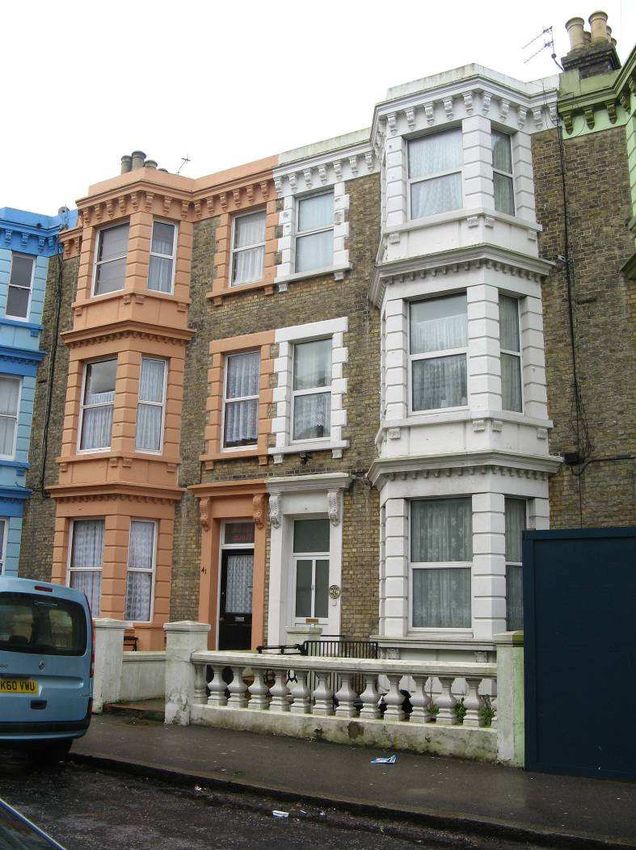
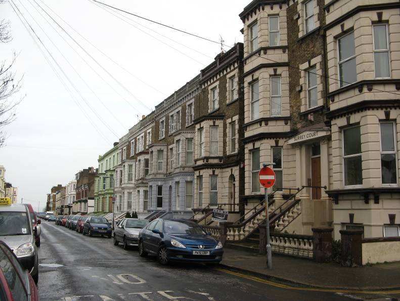
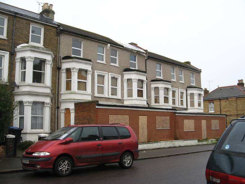
8

The most impressive houses face Edgar Road and are built using Italianate details with large
canted bays to the front and small front gardens fronted by impressive balustraded walls
which reflect the detailing of the buildings behind. Most of them are stuccoed and painted
white or cream, with the occasional use of a rather garish colour such as bright blue or
orange – an issue which is discussed in the Management Plan. Some of the houses have
raised ground floors, so there are wide front steps leading up to the entrances, often
retaining their original cast iron railings. In the past, these houses has suffered from a
general lack of investment, but two groups are currently (Spring 2011) being refurbished to a
very high standard to provide high quality apartments. Further terraced houses can be seen
in Gordon Road and Sweyne Road, though the details are simpler. Whilst most of the larger
terraced houses have been converted into flats or HMOs (Houses in Multiple Occupation),
there are smaller family houses in St Paul’s Road and Stanley Road, where they are largely
arranged in pairs – these appear to date to the 1890s.

There are a few non-residential buildings in the Conservation Area. Cliftonville Hall and a
former school, now used by a Children’s Charity, can be found in St Paul’s Road. Both date
to the 1890s. A private club is located in Percy Road, and there are two care homes and a
hotel (the Glenwood) in Edgar Road.

Issues facing the Conservation Area include the possible serving of an Article 4 Direction to
control front gardens, boundaries and roof details; possible additions to Thanet District
Council’s ‘Local List’ of important buildings; the enhancement of both private and public
spaces within the Conservation Area; the control of new development; the use of colour; the
poor condition of some of the existing historic buildings; and the protection of important
views.

1.2    The control of conservation areas

Conservation areas are designated under the provisions of Section 69 of the Planning
(Listed Buildings and Conservation Areas) Act 1990. A conservation area is defined as “an
area of special architectural or historic interest the character or appearance of which it is
desirable to preserve or enhance”.

Section 71 of the same Act requires local planning authorities to formulate and publish
proposals for the preservation and enhancement of these conservation areas. Section 72
also specifies that, in making a decision on an application for development within a
conservation area, special attention must be paid to the desirability of preserving or
enhancing the character or appearance of that area.

In response to these statutory requirements, this document defines and records the special
architectural and historic interest of the proposed Edgar Road and Sweyne Road
Conservation Area Conservation Area and identifies opportunities for enhancement. It is in
conformity with recently published English Heritage guidance as set out in Understanding
Place: Conservation Area Designation, Appraisal and Management. Additional government
guidance regarding the management of historic buildings and conservation areas can be
found in ‘Planning Policy Statement 5: Planning and the Historic Environment’ (PPS5),
published in March 2010.
9

This document therefore seeks to:

      •   Define the special interest of the proposed Edgar Road and Sweyne Road
          Conservation Area and identify the issues which threaten its special qualities (in the
          form of the ‘Character Appraisal’);

      •   Provide guidelines to prevent harm and also achieve the enhancement of the
          Conservation Area (in the form of the ‘Management Proposals Plan’).

1.3       Community involvement

Informal consultations were carried out with the local community on the proposals for the
new Cliftonville conservation area designations in October 2010, after which a Character
Appraisal and Management Plan for each of the new conservation areas was prepared.
Following this six week public consultation on the Council’s website between (fill in dates),
amendments to the text and mapping will be made as appropriate. Finally, each Character
Appraisal and Management Plan will be adopted by the Council as a material document for
development management purposes.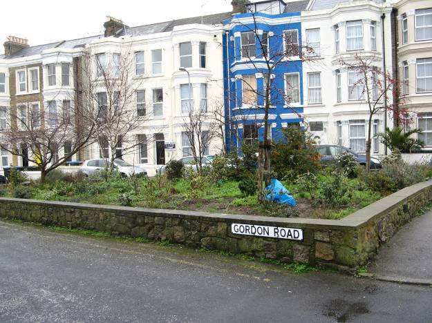
10

2      LOCATION AND LANDSCAPE SETTING

2.1    Location and context

The proposed Edgar Road and Sweyne Road Conservation Area is located within the
western part of Cliftonville, a 19th century expansion of the medieval port of Margate, which
lies immediately to the west. Margate is located on the Isle of Thanet, a coastal district at
the eastern extremity of the county of Kent in south east England. Margate, Ramsgate and
Broadstairs are the principal settlements in Thanet District, and each is famous for its
seaside setting and attractive historic town centres.

Margate is approximately 76 miles south east of London by road and is accessed via the M2
and the A299, the Thanet Way. Railway routes lead to Canterbury, Dover and along the
north coast via Herne Bay and Whitstable to London.

The proposed Edgar Road and Sweyne Road Conservation Area abuts the already
designated Dalby Square Conservation Area to the west, and the proposed Northdown
Road Conservation Area to the south. To the immediate north, the proposed Cliftonville Cliff
Top Conservation Area lies along the seafront, separating the proposed Edgar Road and
Sweyne Road Conservation Area from the promenade and beach.

Properties at the seaward end of Sweyne Road

The Conservation Area lies within the Cliftonville West Ward of Thanet District Council. The
area of Cliftonville is 2.7 hectares and the population (in the 2001 census) was 12,900.
Demographically, the population is predominantly white European.

2.2    Landscape setting, topography and geology

Margate is located over solid chalk, with high chalk cliffs rising to either side of the beach
and harbour in the centre of the town. The Dane valley rises gently southwards through the
town from this beach. Cliftonville lies on roughly level ground on the eastern cliff tops above
the town about 20 metres above sea level, although cuts have been made through the cliffs
11

in previous centuries to allow access to the sandy beaches below Two of these, Newgate
Gap and Hodges Gap, lie within the proposed Cliftonville Cliff Top Conservation Area. A
slight north to south incline in ground level reinforces the opportunities for long views over
the seascape to the north of these cliffs. To the south of Northdown Road, the land falls
steeply – this is most evident in the proposed Grotto Hill Conservation Area.
12

3      HISTORICAL DEVELOPMENT

3.1    Archaeology

Archaeological remains are frequently found in the Cliftonville and Margate areas. The
remains of all periods from the Neolithic to Modern are recorded within the area and consist
of both burial and settlement archaeology.

Archaeological remains of Roman date have been recorded within the Dalby Square
Conservation Area and there is a high potential for further remains of this and other periods
to be present there.

Romano-British activity seems to cluster around both sides of the Dane valley leading up to
the present harbour with most of the activity concentrated at the seaward end of the valley
on both high ground and further down the valley sides. Activity is similarly recorded further
inland, also along the valley sides. A Romano-British cremation burial dating to between 75
and 125 AD was found by workmen excavating a trench in Arthur Road, Cliftonville. The pit
contained a carinated urn in Upchurch Ware filled with ashes and burnt human bone, and
was accompanied by a stamped Samian platter. The burial is recorded by the workmen as
having been truncated by former Victorian ground works and sealed by a floor. Other
Roman burials are known from the Britannia Public House, Fort Hill site, located to the west
of Cliftonville.

3.2    The development of Margate

Margate developed from a minor medieval port to a seaside resort from the mid-18th century
onwards. By 1800 the town had assembly rooms, residential squares, bathing
establishments, libraries and theatres, all designed to cater to the needs of aristocratic
visitors – the only class of society to take ‘holidays’. In 1828 increased numbers resulted in
Holy Trinity Church being built on what was then the eastern edge of the town, close to what
was to become Ethelbert Road, as a chapel-of-ease to St John’s – it was soon extended to
provide 800 rented pews and 1,200 free seats. In 1845 the land which was to later develop
as Cliftonville was still fields with a Coastguard Station on the cut through the high cliffs
which dropped down to the beach (now Hodges Gap). The arrival of the railway in 1846,
and the addition of a further line and station in 1863, changed the type of visitor to the town
from a limited number of wealthy long stay guests to a greater number of short stay visitors
with less per capita income.

The town’s established place in public consciousness was a good foundation for creating a
new resort in Cliftonville, a resort that reversed the popular perception that Margate was
increasingly becoming an attraction to the pleasure-seeking working classes. Cliftonville’s
distance from the town centre, and its open cliff-top walks, were promoted as part of its
exclusivity – Cliftonville was a place where one stayed to improve one’s health and peace of
mind, all year around if necessary. In 1824 Clifton Baths were built to provide an opportunity
to bath in heated seawater ‘for the nobility and gentry’, and in 1855 Thomas Pettman leased
the cliff-top shoreline from the Marquis of Conyngham so he could access his Bathing
Platform down one of the old gaps on the cliff face (Newgate Gap) which had been created
by farmers collecting seaweed from the beach. At this time other major land-owners in
Cliftonville included the Church Commissioners and charities such as the Bethlehem
Hospital and the Ragged School Union.
13

The exclusivity of Cliftonville was bolstered by the area’s relative isolation. Until the building
of a tramway in 1901 the only method of transport from Margate’s stations was by horse
brake. Access was improved in the late 1880s by the building of Marine Drive which
completed the seafront thoroughfare from Buenos Ayres to Eastern Esplanade. Between
1880 and 1899 the station of the London, Chatham and Dover Railway Company was
known as ‘Margate and Cliftonville’ (it was later to be known as ‘Margate West’). Plans for a
branch line from Margate to Cliftonville, with a terminus at the rear of Dalby Square, were
first proposed in 1893 but were never implemented.

The association of the area with a ‘better class of person’ became the key selling point for
the new resort. The entry for Cliftonville in the Ward Locke Guide of 1903 stated:

       It is the most exclusive and aristocratic part of Margate. It cannot be said too often
       that there are two Margate’s and that Cliftonville has scarcely anything in common
       with the area frequented by the vulgar tripper. Cliftonville has magnificent hotels with
       their private orchestras and admirable cuisine catering for all types of continental
       clientele. It has been often said that on a Sunday morning between Newgate
       Gapway and Hodges Flagstaff one may see the prettiest and best dressed women in
       Europe’.

The centrepiece of this ‘Margate New Town’ was Dalby Square, with a massive terrace of
seven houses, Warrier Crescent, on the south side. This space had been laid out by the
1850s, and was originally called Ethelbert Square, the name being changed to Dalby Square
in the 1870s after the then mayor (and local builder), Thomas Dalby Reeve, who also owned
both the Clifton Baths and the Hall by the Sea. The Reeve family was one of the early
developers of the Cliftonville estate, and Dalby Reeve’s son Arthur, after whom Arthur Road
is named, married George Sanger’s daughter Harriet. George Sanger and his brother John
Sanger, who is buried in Margate Cemetery, were circus proprietors who were famous for
their equestrian spectacles. They leased the Agricultural Hall at Islington and their show
was eventually purchased in 1874 by the American showman P T Barnum.

In 1868 the Cliftonville Hotel, located at the eastward end of Dalby Square, was opened. It
is noted that at that time it sat ‘on an island site in the middle of corn fields’. The hotel had
250 bedrooms, a dining room which could hold over 300 people, a ballroom, a palm court
and facilities for croquet, tennis and archery amidst formal gardens along the cliff top. In all,
the hotel provided the accommodation for about 50% of all hotel guests in Cliftonville, but by
1890 this figure had dropped to around 15% as so many other hotels had been built.

Another important contribution to the locality was provided by the large number of private
schools. A resort guide of 1893 described Cliftonville as:

       ‘The end of the town affected by visitors who like a good address, and also by ladies’
       schools, if one may judge by the endless chain of them travelling churchwards on
       Sundays.’

Northdown Road was developed from the 1870s onwards– it is shown as nearly completely
built-up as far as Harold Road on the 1899 Map, although in 1900 less than 12 shops are
recorded. However, by 1912 many of these new houses had been converted into
commercial premises, no doubt assisted by the provision of the new tramway from Margate
town centre in 1899. St Paul’s Church (now St Michael and St Bishoy’s Church) was
consecrated in 1873 and St Stephen’s Wesleyan Methodist Church was opened in 1876 –
14 they are both in Northdown Road. St Anne’s Roman Catholic Church was built on the Eastern Esplanade in 1926. In 1900 the Cliftonville Hydro Hotel with 110 bedrooms was opened, later being renamed the Grand Hotel (from 1956 this formed part of Butlins). By 1900 a grid pattern of streets off Northdown Road had also been completed (Edgar, Sweyne, Godwin, Harold, Norfolk and Surrey Roads), all with a mixture of houses and guest houses along them. In 1913 ‘Bobby’s’ was opened as a department store in Northdown Road, although it closed in 1973. Along the seafront, the Oval, a former school cricket field, was excavated in 1897 and an amphitheatre created with a new bandstand being added in 1903. This area became the centre of Cliftonville’s entertainments for the next 50 years with many concerts and other events taking place. In 1906 mixed sea bathing was finally allowed in Margate, and by 1913 donkey (or ‘Jerusalem pony’) rides were being provided by local gypsies along the sea shore. After World War 1 the Borough of Margate was increasingly seeing Cliftonville as the prime attraction of the town and in 1920 the Council acquired the cliff top land from Sacketts Gap to the Borough’s eastern boundary – 61 acres in all. This land was used to provide new public walks and pleasure grounds, continuing the 19th century concept of promoting Cliftonville as a health-giving place where the benefits of sea water and sea air were unparalleled. The Clifton Baths site was acquired by John Henry Iles, the promoter of Dreamland and Ramsgate Dog Track, in the early 1920s, and the buildings were demolished and redeveloped by 1926 as the complex which later became known as the Lido. The attractions included a café, cinema, and concert hall as well as an open air seawater bathing pool on foreshore land which was leased from the Council – this could accommodate up to 1,000 bathers. The growth of Cliftonville during this period between the late 19th and the early part of the 20th century is demonstrated by the number of Cliftonville school children – around 2,000 in 1885 and about 5,000 in 1922. Cliftonville continued to thrive until World War 2, and Dalby Square particularly was noted for the prestigious hotels, guest houses and convalescent homes which fronted it. However, the War saw the evacuation of schools to other parts of the country and most never returned. Warrier Crescent suffered bomb damage and was only partially reconstructed after the War – it was finally demolished in its entirety in 1988. Holy Trinity Church was also bombed in 1943, leaving a tower which has also been demolished – the site is now a car park. From the 1960s onwards the provision of cheap holidays to Spain and other exotic locations completed a process which had begun some 30 years earlier. Many of the bigger hotels closed or were converted into flats, the demolition of the Cliftonville Hotel in 1961 being particularly disastrous as it was replaced with a poorly designed complex of buildings which are currently used as a café, public house, bowling alley and other leisure-related facilities.
15
3.3 The development of the proposed Edgar Road and Sweyne Road Conservation
Area
This Conservation Area was largely developed between the late1870s and 1900. By 1845
development from Margate town centre had only reached as far as what was to become
Ethelbert Road, which today forms the western boundary of Cliftonville. The National
Freehold Land Society first leased out plots from Ethelbert Road to Godwin Road, the first
development occurring around Dalby Square, which was laid out by the 1850s. The massive
scale of the prestigious houses around Dalby Square was continued into the immediately
adjoining Edgar Road, but started much later – the map of 1879 shows both Edgar Road
and Sweyne Road laid out but without any buildings apart from Nos. 1-4 Edgar Road, and
the Clubhouse in Percy Road, which were both close to the Cliftonville Hotel (now
demolished). However, the map of 1899 shows all of the present buildings in the
Conservation Area apart from the north side of St Paul’s Road, where the houses date to the
1920s or later. Many of the new buildings were built as hotels or guest houses, uses which
continued until relatively recently, and, because of this, the buildings in Edgar Road and to a
degree, Gordon Road, are on a much larger scale than the smaller properties in Stanley
Road or St Paul’s Road.
Nos. 1-4 Edgar Road Glenwood Hotel, Edgar Road
3.4 Activities
The Conservation Area is mainly in residential uses, with most of the buildings (but not all)
having been divided into flats or houses in multiple occupation (HMO’s). Whilst a detailed
survey has not been carried out, there may be only a few houses still in single family
occupation, the most concentrated groups being in Stanley Road, St Paul’s Road, and
possibly in Sweyne Road, where the buildings are smaller so conversion to flats was more
difficult. In the past, many of the larger buildings in Edgar Road were used as hotels, but the
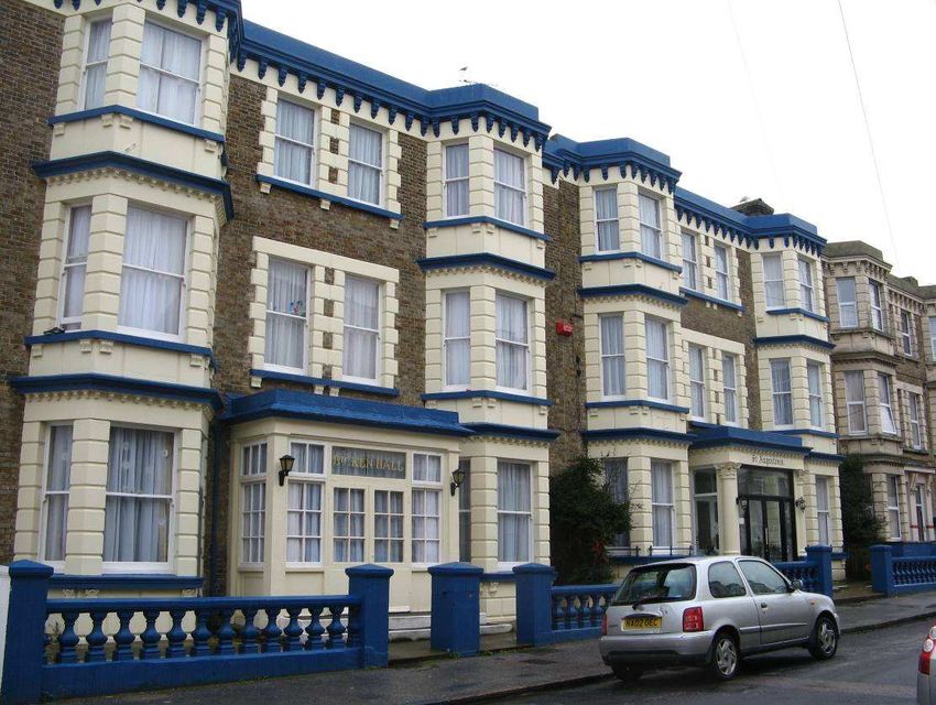
only survival of this use appears to be the Glenwood (Nos. 20-23 consec.) in Edgar Road.
Further hotels are shown in the same street on quite recent maps but one on the west side
of the road is now the Montagu Care Home, and a larger hotel complex further south now
forms part of a large site (Nos. 37-51 Edgar Road) which at the time of survey was being
converted into flats by a developer called Pinnacle Real Estate Ltd, who are also converting
Nos. 26, 27 and 28 Edgar Road on the opposite side of the road. It is not clear what St
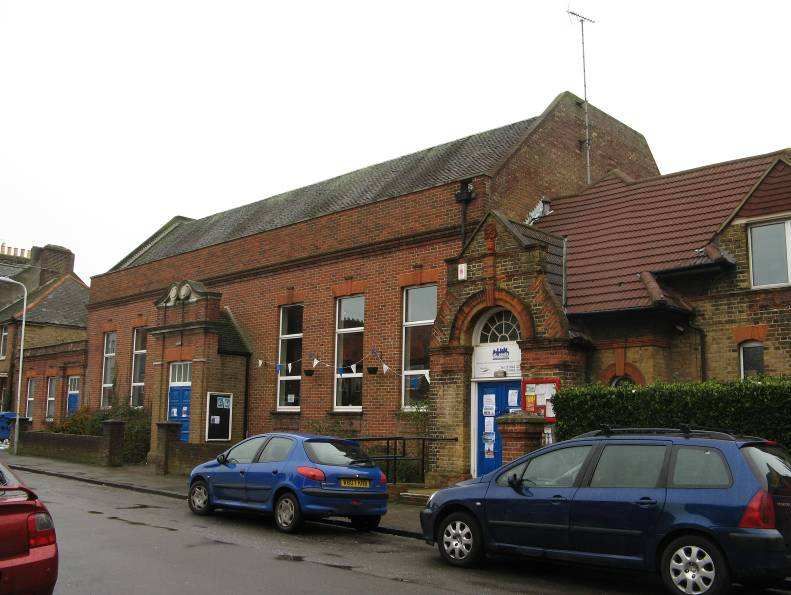
Augustines on the east side of Edgar Road is used as – the four buildings which together16 form the unit may be either a hotel or some form of housing – but the buildings are well maintained and the sash windows original. Opposite, No. 64 is the Elizabeth Anne Care Home. The Clubhouse in Percy Road is also in some sort of use as a bar or club and appears to be open to members only. In St Paul’s Road there is a notable late 19th century hall which is owned and managed by the St Paul’s Community Trust – Cliftonville Hall is the only community building in Cliftonville and therefore provides a number of important local services as well as being a focus for community interaction. A former school on the opposite side of the road is now used by the Sure Start Children’s Centre.
17

4      SPATIAL ANALYSIS

4.1    General character and plan form

The proposed Edgar Road and Sweyne Road Conservation Area was built on open fields as
part of the development of Cliftonville between the 1880s and 1890s, when the streets to
either side of Northdown Road were laid out in a grid pattern, those on the north connecting
the commercial core of Cliftonville with the seaside activities along the promenades. This
provided a perfect location for hotels and guest houses, with the added attraction of the
close proximity of the area’s principal hotel, the Cliftonville, which was located at the
northern end of Edgar Road. As a result, many of the original buildings in the Conservation
Area were large, four storey Italianate terraced houses which have since been largely
converted into flats. These are concentrated in Edgar Road, with slightly less prestigiously
detailed houses (though of a similar size) in Gordon Road. However, the map of 1907
confirms that the north-western end of Edgar Road was only partially developed as some of
the back gardens to the houses facing Dalby Square carried through to Edgar Road, and
these plots were therefore developed much later – hence the infill buildings in this part of the
Conservation Area. More modest two storey houses, arranged in pairs or short terraces,
can be seen in St Paul’s Road and Stanley Road. All of the houses follow a common
building line, and many have small front gardens or front areas with front steps to raised
ground floors and basements below. Where there are gardens, the provision of small
amounts of planting and a few small trees provide some softening to the views along the
streets. Many of these have notable boundary walls, particularly in Edgar Road.

West side of Edgar Road

The plan form of the Conservation Area is simple and was constrained by Dalby Square to
the west, Northdown Road to the south, and the seaside promenades and other open
spaces to the north. The two main streets, Edgar Road and Sweyn Road, lie at right angles
to the sea although this pattern was slightly changed in the centre of the Conservation Area
in Gordon Road. Here, the space between the long terraced buildings on either side of the
road was widened to create a small raised ‘green’, which has been landscaped with plants
18

and some trees. A few street trees also remain. Improvements to the ‘green’ are further
discussed in the Management Plan.

4.2      Focal points, focal buildings, views and vistas

Focal points and focal buildings:

The simple grid pattern of streets, and the cohesive development on either side of each
road, means that there are no focal points and that no one building particularly stands out.
The ‘green’ in Gordon Road provides some open space but its present appearance is poor
and it is heavily enclosed by parked cars. St Michael and St Bishoy’s Church (the former St
Paul’s Church) is a focal building along St Paul’s Road, but of course it lies within the
adjoining Northdown Road Conservation Area. Other, though lesser, focal buildings are:

•     Nos. 1-4 Edgar Road
•     Cliftonville Hall, St Paul’s Road
•     Building on the corner of Percy Road and Sweyne Road

View down Gordon Road to Stanley Road         View from seaward end of Sweyne Road

Views and vistas

Views along each of the two main streets are of some note, particularly down Edgar Road,
where the views are framed by the very substantial Italianate buildings on either side.
However, there are no views out of the Conservation Area apart from glimpses from the
northern end of Sweyne Road over modern development towards the cliff-top promenade
and The Oval. Stimpson House is a large block of flats which has recently been built on the
east side of Sweyne Road (i.e. outside the Conservation Area) which effectively blocks any
further views to the north-east, and views from the northern end of Edgar Road are similarly
blocked by the 1960s development which replaced the Cliftonville Hotel.

The most important views are marked on the Townscape Appraisal Map but the omission of
any particular view does not mean that it is not significant.
19

4.4     Boundaries

The orientation of the buildings to the street, with small front gardens or basement areas,
means that front boundaries are extremely important in the Conservation Area although
unfortunately they have been neglected, removed or altered in many locations. Where there
are basements, the front steps are often particularly important and many are bounded by
their original plinth walls with cast iron railings of various designs. Examples can be seen on
the south side of St Paul’s Road (Nos. 1-17 odd) where the houses have half basements
defined by a low brick plinth walls and cast iron railings with very decorative ‘flower’ panels
set into short spiked uprights with spear heads (similar railings can be seen in the Ethelbert
Road and Athelstan Road Conservation Area). No. 9 Edgar Road has highly decorative
‘Gothic’ cast iron railings protecting the basement front area – these are in good condition
but painted an unfortunate orange colour. Elsewhere, many of the front boundaries are
simply low brick walls (often painted), with moulded stone copings, as can be seen
throughout Gordon Road.

Railings in front of No. 9 Edgar Road           Typical wall detail, Edgar Road

The most visually dramatic boundaries in the Conservation Area can be found in Edgar
Road where many of the houses retain their original stuccoed balustraded front walls set
between simple piers, also stuccoed. These reflect the detailing on the houses next to them.
It is imperative that these walls are protected, and where they have been removed they
should be restored at the earliest opportunity.

Less attractive are the modern boundaries to properties in St Paul’s Road including concrete
blocks and timber trelliswork, and further modern boundaries can be seen throughout the
Conservation Area, all of which should ultimately be removed and replaced with details
which are more in keeping. In Sweyne Road, Nos. 40-46 even have ground floor extensions
which have infilled the small front gardens to the great detriment of the streetscape.

4.5     Public realm

The public realm covers the spaces between the buildings including pavements, roads,
street lighting, street furniture, and any other features of local significance. Most of them will
be the responsibility of the Highways Department of Kent County Council.
20

There is little original floorscape in the Conservation Area apart from some setted or stone
slab gutters and narrow (150 mm) granite kerbing. These can be seen in many locations in
the Conservation Area. Decorative cast iron coal holes do remain in the pavements outside
the houses in several locations, often set into the original sandstone flag. One example on
Edgar Road is marked Stevens Bros Margate and Broadstairs.

Cast iron coal hole cover in Edgar Road      ‘Cliftonville’ nameplate for St Paul’s Road

Otherwise, the features are all modern – steel street lights, modern black and white street
name plates (black lettering on white), and tarmacadam (or concrete slab) pavements and
carriageway surfaces. A few original ‘Cliftonville’ street nameplates remain, such as the one
for St Paul’s Road – these are cast iron with decorative mouldings and white lettering on
black background. A further blue enamel street nameplate (probably 1930s) also remains
above the modern version, all three on the same corner of St Paul’s road and Edgar Road.
21

5        THE BUILDINGS OF THE CONSERVATION AREA

5.1      Building types and dates

Nearly all of the buildings in the proposed Conservation Area were built as family houses or
as small hotels or guest houses between the late 1870s and the early 20th century. St Paul’s
Road contains a group of possibly 1920s houses (Nos. 10-18 even) with 1960s or later infill
immediately to the west. There is further modern infill in Edgar Road (Nos. 52-55 consec.)
and more recent flat development further north along the street. St Paul’s Community Hall
and the adjoining former school building probably date to around 1900.

5.2      Listed buildings

There are currently no listed buildings in the proposed Conservation Area.

5.3      Locally listed buildings

There are currently no locally listed buildings in the proposed Conservation Area, but the
Management Plan includes a recommendation to add the following buildings to the emerging
Local List:

•     St Paul’s Community Hall, St Paul’s Road
•     Stay Safe Children’s Centre, St Paul’s Road

St Paul’s Community Hall, St Paul’s Road

5.4      Positive buildings

Most of the buildings in the proposed Conservation Area have been identified on the
Townscape Appraisal Map as being positive buildings of townscape merit. Buildings
identified as being positive will vary, but commonly they will be good examples of relatively
unaltered historic buildings where their style, detailing and building materials provides the
streetscape with interest and variety. Most importantly, they make a positive contribution to
22

the special interest of the conservation area. In the Edgar Road and Sweyne Road
Conservation Area, most of these buildings date to between the 1870s and the early 20th
century, where they form cohesive terraces with well preserved elevations. Slightly later
buildings of slightly lower quality can be found in St Paul’s Road, dating to the 1920s or
1930s (Nos. 10-18 even), but is considered that these are also positive although careful
restoration of their front facades would be welcome. Similarly, Sweyne Road contains
several groups of rather altered historic buildings where improvements are needed, such as
the removal of the ground floor extensions to Nos. 40/42.

Typical ‘positive’ property in Edgar Road

The identification of these ‘positive’ buildings follows advice provided within English
Heritage’s Understanding Place: Conservation Area Designation, Appraisal and
Management, which provides a helpful list of criteria for their selection. The guidance
advises that a general presumption exists in favour of retaining those buildings which make
a ‘positive’ contribution to the character or appearance of a conservation area.

Proposals to demolish such buildings will therefore be assessed against the same broad
criteria as proposals to demolish listed buildings. This implies therefore that all buildings
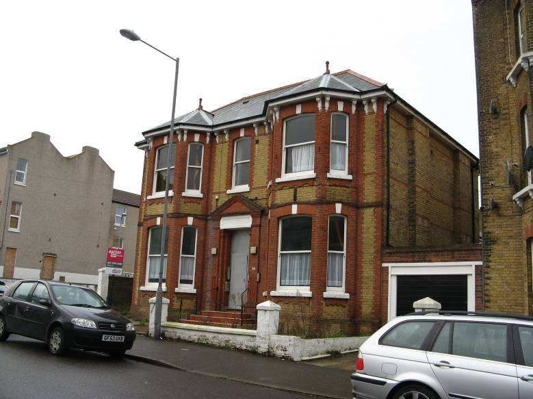
23

marked as ‘positive’ on the Townscape Appraisal Map will be retained in the future unless a
special case can be made for demolition.

5.5    Building styles, materials and colours

Terraced residential property dating to the late 19th century provides the predominant
building type in the Conservation Area. None of the properties in the Conservation Area are
shown on the map of 1879 apart from Nos. 1-4 Edgar Road and the Clubhouse in Percy
Road, and it can therefore be safely assumed that most of the buildings date to between the
very late 1870s and 1899, when the map of that date confirms the completion of nearly all of
the street frontages. The largest and highest status buildings are to be found in Edgar
Road, with slightly smaller terraced houses, with less decoration, in Gordon Road and parts
of Sweyne Road. All of these are largely stuccoed with Italianate details (for the earlier
examples) or more Gothic details (for the houses which date from around the 1890s
onwards). Stanley Road and St Paul’s Road contain mainly paired or terraced brown brick
houses, stylistically a little later in date (1890-1900).

Houses in Stanley Road

Nos. 1-4 Edgar Road are the earliest buildings in the Conservation Area and are shown on
the 1872 map. They form a tall (four plus half basement) storey terrace built from red and
yellow brick with canted bay windows to all but the top floor. Heavily moulded parapets
conceal the roofs. Their principal feature is the survival of a first floor continuous balcony
with its original cast iron railings which stretches across all four facades, and is topped by a
curved canopy which may have once have been covered in lead. All of these properties are
in poor condition. Around the corner in Percy Road, the Clubhouse is a three storey
symmetrical house with a hipped slate roof, two over two timber sashes, and central front
door. These details, and the rusticated quoins to the corners, suggest a date of around
1860-1870.

The remaining terraced houses in Edgar Road are the largest and most impressive in the
Conservation Area, being similar in detailing but later in date to the prestigious Italianate
houses which face neighbouring Dalby Square. They are three or four storeys high with
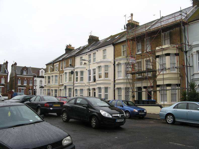
24

canted bay windows and slate roofs concealed by parapets. Some of the ground floors are
raised with half basements which once provided the kitchens and other service rooms for the
family houses which lay above. The stucco and brick elevations are often lined out to
replicate stone and there are also stone string courses with decorative cornicing. Some of
the original single paned timber sash windows remain, but largely they have been replaced
in uPVC, usually with a fixed lower pane which does not replicate the overall design. The
small front gardens are often bounded by balustraded stucco walls which are extremely
important in views along the street. No. 41 retains its original decorative tiled entrance path,
as well as its cast iron area railings, which can also be found in front of many houses in the
road. There has been some infilling on the north-west side of the road, a small terrace (Nos.
52-55 consec.) being particularly unfortunate as it neither replicates the scale or building line
of the historic buildings to either side. A larger development towards the northern end of the
road is more successful in townscape terms. Whilst most of the properties have been
painted cream, a number have been painted with garish colours such as green, orange and
blue. It is assumed that these inappropriate colours will not be replicated when the
restoration of the houses by Pinnacle is completed. The principal building of the Glenwood
Hotel is to be found in No. 19 Edgar Road, but it has expanded into part of the slightly lower
terrace on the south side (Nos. 20-25 consec). These six properties, two and a half storeys
high, are built from red brick with ground floor and basement canted bays. The roofs are
slated, and stylistically, these houses are more in keeping with the red brick houses in
neighbouring Stanley Road.

Gordon Road houses with original windows       Nos. 10-18 St Paul’s Road

The terraced houses which face Gordon Road are three storeys high without half
basements. They also have canted bay windows but these are only two storeys high, with
the sashes separated by brick piers with capitals decorated with leaf mouldings in the Gothic
style. On the west side of the road, the eaves retain corbelled brick details with pitched roofs
facing the street. These are usually covered in modern tiles but originally would have been
slate – a few examples remain. On the east side of the road, the pitched roofs are partially
concealed by moulded parapets. Some of the houses have converted their attics, so roof
lights or dormers have been added to these front-facing roof slopes. Simple brick chimney
stacks, often with ten original clay pots, are a notable feature. A few areas of brown brick
can be seen, but mostly the buildings are painted a cream colour which provides a more
cohesive streetscape although the occasional house has been painted a less appropriate
colour, such as bright blue. Many of the original four panelled timber front doors remain
25

The houses along Stanley Road, which face down Gordon Road, date to the 1880s or even
1890s and are two storeys high plus a half basement and original attic rooms, lit by a single
well detailed dormer. They are built using brown brick, with red brick dressings to the
windows and ground floor canted bays. Some of the original slate roofs remain but often
these have been replaced in concrete tiles. Key stones over each window are often picked
out in white against the red and dark brown background. Most but not all of the original
windows and front doors have been replaced in uPVC or similar – No. 2 retains its original
four panelled front door with heavy mouldings.

St Paul’s Road contains the Community Hall and adjoining former school, which are
described in greater detail in the Management Plan. The Hall lies next to a short terrace
(Nos. 1-17 odd) of two storey late 19th century houses which are built from brown brick with
red brick dressings similar to the properties in Stanley Road, although a few have been
painted. Again, many of these have original dormers with carved barge boards, and, below,
there are canted bay windows to the half basement and ground floors. Decorative cast iron
railings protect the small front areas. Nos.1-4 consec. are similar but smaller, with no
basements and more shallow pitched roofs which are partially concealed by brick parapets
which are decorated with corbelling.

Corner building, Sweyne Road

On the opposite side of the road, Nos. 10-18 even. St Paul’s Road probably date to the
1920s with gables separating areas of false timbering in the Tudorbethan style. Roof
dormers with curved metal covered canopies are an unusual feature and appear to be
original. The ground floor bay windows and front doors are protected by a long mono-
pitched roof which stretches across all of the facades to create covered porches. Whilst
most of the windows have been replaced apart from No.16 (which pleasingly retains all of its
original features), it is considered that this terrace could be upgraded by the use of a
common palette of colours and window details to recreate the cohesiveness of the original
design.
26

Whilst some of Sweyne Road is shown as developed on the 1879, these buildings on the
east side of the road have now been much altered (or demolished) and are not included in
the Conservation Area. Most of the buildings on the west side of the road, which are within
the Conservation Area, date to the 1880s or 1890s, the later buildings being closer to
Northdown Road. The northern end of the road, where it meets Queen’s Parade, contains
an interesting corner building of c1905 with typically Edwardian details including an ogee
roofed corner feature and decorative first floor balconies with original timber railings. A wide
gable facing Percy Street is another dominant feature. Next door, a very altered three and a
half storey building is notable for its ornate cast iron first floor balcony railings with curved
ogee roof above.

The remaining houses in this group as far as the junction with Stanley Road are quite mixed,
with an initial group of three and a half storey painted brick houses with full height canted
bays and concealed roofs, leading on to a number of yellow brick with red brick dressings
properties which presumably are slightly later in date. No 36 retains its original front door
with two curved glazed panels over a single heavily moulded panel below. Next door, No.
38 is an unusual building in that it is (just) a free standing double fronted two storey villa,
with double height canted bays, Gothic detailing, and a pitched roof facing the street. This
property is unusually well preserved with its original sash windows and slate roof covering.

No. 38 Sweyne Road

Further along Sweyne Road, the first four properties (which form part of a larger three storey
terrace) have been ruined by ground floor extensions and pebble-dashed brickwork which
should all be removed so that the facades match the terrace of which they form a part. The
restoration of the front gardens would be particularly welcome. This three storey group have
two storey canted bays with Gothic foliage details, the detailing continuing into the
neighbouring properties which are only two storeys high. All are built from brown brick with
mainly concrete tiled roofs facing the street. The final group of properties, between the
junction of St Paul’s Road and Northdown Road, are also late 19th century and built from
brown brick with red brick dressings and canted bay windows – one has been completely
27

rebuilt as a rather poor copy of its neighbours. Original dormers which break through the
eaves lines have curved bargeboards which add to the variety of rooflines in views along the
road. These properties are very similar to the houses along the south side of Stanley Road,
but larger.
28

6        THE EXTENT OF INTRUSION OR DAMAGE

6.1      Key negative features

This Character Appraisal concludes that the most significant negative features of the
proposed Edgar Road and Sweyne Road Conservation Area are (street by street):

Edgar Road

Spatial:

•     The loss of front boundaries, including original railings and balustraded front boundary
      walls, and the use of modern boundary treatments
•     A general lack of any green space or trees
•     Poor quality pavements, many of which have been poorly resurfaced after work by the
      utility companies
•     Modern street lighting and overhead cables
•     Dominance of parked cars along both sides of the road

Buildings:

•     Poor quality ground floor extension to No. 64 (Elizabeth Anne Care Home)
•     Modern development (Nos. 52-55 consec.) whose scale and relationship to the street is
      inappropriate (including the creation of off-street car parking spaces)
•     Use of garish colours for external painting of walls and details
•     A plethora of satellite dishes on many buildings
•     The replacement of original timber sash windows using uPVC with top hung lights (or
      similar)
•     The National Tyre and Autocare Centre at the southern end of Edgar Road, which lies
      just within the Northdown Conservation Area, with its bright red and yellow façade
•     Ugly 1960s development at the north-western end of the road, within the Cliftonville Cliff
      Top Conservation Area
•     The high number of flats and houses in multiple occupation
•     Some of the buildings, particularly Nos. 1-4 Edgar Road, are in poor condition
•     Exposed flank walls at road junctions

Gordon Road and Stanley Road:

Spatial:

•     The ‘green’ in the middle of the road is in urgent need of better quality planting and
      maintenance in general
•     Indiscriminate car parking
•     Poor quality modern street lighting
•     Back access alleys are in need of improvements

Buildings:

•     Use of concrete tiles for the many of the roofs
29
• Loss of chimney pots and chimney stacks
• Over-dominant roof dormers and roof lights on front roof slopes
• The high number of flats and houses in multiple occupation (though Stanley Road does
have some houses which appear to be in use as family dwellings)
• Poorly maintained buildings, many of them in need of redecoration and repair
• Many of the buildings on the west side of Gordon Road have one or more satellite dishes
• Use of different paint colours for the elevations, which reduces the cohesiveness of the
groups
• Changes to windows and front doors, usually in uPVC
• Poorly maintained or missing front boundaries
St Paul’s Road:
Spatial:
• The north side of St Paul’s Road contains a group of 20th century house of varying ages
of no special interest whose contribution to the character and appearance of the
Conservation Area is, at best, considered to be ‘neutral’
• Pavements covered in poor quality concrete flags or tarmacadam
• Poor quality street lighting
• The impact of the garish colours on the setting of Cliftonville Hall by the adjoining
National Tyres and Autocare centre
• Glimpses down poorly maintained back access alleys
Buildings:
• Poor maintained front boundaries, and the use of poor quality modern materials for front
boundaries
• Loss of front gardens to car parking
• Some of the buildings are in need of routine maintenance and repairs
• Use of uPVC for windows and front doors
Sweyne Road:
Spatial:
• Dominance of parked cars
• Very little greenery or trees
• Poor quality modern street lighting
Buildings:
• Satellite dishes on many of the buildings
• Use of uPVC for many of the windows
• Buildings have lost original features and window openings have been changed
• Front extensions have been added to several of the houses
• The high number of flats and houses in multiple occupation
• Many of the properties are in urgent need of routine maintenance of more through
repairs30
• Poor quality front boundaries, some of which have been removed or allowed to
deteriorate
• Empty and boarded-up properties
6.2 Summary of issues
Taking the ‘negative features’ identified above into account, the following issues are
considered to be the most pressing matters which need to be addressed by the
Management Plan for the proposed Edgar Road and Sweyne Road Conservation Area:
The control of new development
• Ensuring that all new development is of the highest possible standards
The protection of views
• Protecting and enhancing the important views into, out of, and around the Conservation
Area
The public realm
• Upgrading the space between the buildings – the pavements, street surfaces, street
lighting and signage
The control of car parking and traffic
• Providing guidance to reduce traffic and control car parking
The control of unlisted buildings (Article 4 Directions)
• Preserving and enhancing the existing historic buildings in the Conservation Area,
particularly:
• Front boundaries
• The creation of car parking areas
• Roof materials and chimneys
• Painting of previously unpainted surfaces
Building condition and the role of grant aid
• The need for repairs and restoration works, including the need for grant aid
The Local list
• Suggestions for Local Listing
Site specific recommendations
• Gordon Road green
Education and guidance
• Education and publicity, including encouraging civic pride and a sense of place
Monitoring and enforcement
• Providing a strategy to carry forward the recommendations in the Management Plan
• Continuing to monitor the condition of the proposed Conservation Area, including regular
updates of the Management Plan31
• Taking record photographs on a four year cycle to assist with monitoring and to use in
any future enforcement proceedings32
PART 2 THE PROPOSED EDGAR ROAD AND SWEYNE ROAD
CONSERVATION AREA MANAGEMENT PLAN
1 INTRODUCTION
1.1 The purpose of the Management Plan
Part 1 of this document, the Character Appraisal, has identified the special positive qualities
of the proposed Edgar Road and Sweyne Road Conservation Area which make the
conservation area unique. Part 2 of this document, the Management Plan, builds upon the
positive features and addresses the negative features which have been identified to provide
a series of recommendations for improvement and change, most of which are the
responsibility of Thanet District Council or Kent County Council.
The involvement and approval of the local community in the formulation and delivery of
these documents helps to strengthen their status and will hopefully mean that the various
actions identified in the Management Plan will have greater impact and longevity. For Edgar
Road and Sweyne Road, this has been achieved through the current six week public
consultation exercise. Any necessary amendments will then be made before the final
version of the document is completed. The document will be adopted by the Council as a
‘material’ document for development management purposes.
1.2 Relevant documents
The structure and scope of this document is based on the suggested framework published
by English Heritage in Understanding Place: Conservation Area Designation, Appraisal and
Management (2011). Both the Conservation Area Character Appraisal and the Management
Plan should be subject to regular monitoring and reviews, as set out in section 3.
Other relevant documents include:
• The Planning (Listed Buildings and Conservation Areas) Act 1990
o This Act sets out the legislative background for the control of conservation
areas and listed buildings.
• Planning Policy Statement 5 (PPS5)
o This provides recent (March 2010) government policies which relate to the
historic built environment, and is accompanied by detailed guidance on the
interpretation of the PPS by English Heritage.
• The Kent Design Guide
o This advocates high quality design for all new development and provides
detailed guidance.
Documents produced by Thanet District Council:
• The Thanet local Development Framework (which is incrementally replacing the Thanet
Local Plan 2006)
• The Margate Renewal Study (undated but post-2006)
o This document was commissioned by the Margate Renewal Partnership to
carry out a study of the drivers of deprivation in Margate Central and33
Cliftonville West Wards and make recommendations on future regeneration
activity to tackle deprivation.
• Conservation Areas in Thanet – Conservation Areas Management Plan (March 2008)
o This document sets out the Council’s approach to the management of the
conservation areas within Thanet – it draws on both national and local
planning policies
Documents produced by Thanet District Council which relate specifically to Cliftonville:
• West Cliftonville Neighbourhood Renewal Area (2006)
o This report produced by Thanet District Council and consultants identifies the
need to improve the housing stock in four parts of Thanet including Cliftonville
West, and provides some policy guidance.
• The Cliftonville DPD (February 2010)
o This document provides planning policies for the Cliftonville West Renewal
Area (in advance of the Core Strategy) to be used to inform development
control decisions on the large number of planning applications which are
submitted in the area – its main thrust is to enhance the existing building
stock in terms of physical condition and use (particularly the reduction in
number of poor quality flats and their replacement with family houses),
encourage community pride in the area, and support the growth of high
quality tourism-related facilities. One of the outcomes of this DPD is the
imposition of a surcharge on local landlords which is aimed at encouraging a
reduction in the number of small residential units, and an increase in the
number of family dwellings within the Cliftonville area.
1.3 The scope of this Management Plan
This Management Plan has been drawn up following detailed survey work of the proposed
Edgar Road and Sweyne Road Conservation Area by The Conservation Studio in
collaboration with Thanet District Council’s conservation staff. Its recommendations relate
specifically to the Conservation Area, and it is not intended to include general advice about
the control of conservation areas, which is set out in the Council’s document Conservation
Areas in Thanet – Conservation Areas Management Plan (March 2008 presently under
revision). This document also includes advice about the quality of new development which
will be needed in all of Thanet’s conservation areas, and may be amended and updated in
the future once the current work on the new conservation areas in Cliftonville is complete.You can also read