Public Hearings Committee - May 04, 2021 - Norfolk County
←
→
Page content transcription
If your browser does not render page correctly, please read the page content below
Working together with our community

                                                                                Page 1 of 15

                     Public Hearings Committee – May 04, 2021
Subject: OPNPL2020234 and ZNPL2020235 – An application has been received to
amend the Official Plan to include a site-specific policy to the existing 'Agricultural'
designation to permit 'Farm Condominium Dwelling Units' with resort-oriented on-farm
diversified uses including food and beverage services, group tourist cabins and
conference centre. A Zoning By-Law amendment is also associated with this application
to add a special provision to the current 'Agricultural' zone to permit single detached
dwellings and on-farm diversified uses including tourist cabins, riding arena and stables,
wedding & conference centre and a saloon. G. DOUGLAS VALLEE LTD. on behalf of
JEFF BOUCK has put forth the application affecting the lands described as 436 Front
Road, St. Williams, Ontario.

Report Number:             CD 21-30
Division:                  Community Development
Department:                Planning
Purpose:                   For Information

Executive Summary:
An application has been received to amend the Official Plan and Zoning By-Law for
lands currently designated and zoned ”Agricultural” with the following site specific
proposed additional permitted uses:

Official Plan Amendment: to add a Site-Specific Policy to permit “Farm Dwelling Units”
in the form of a condominium, with On-Farm diversified Uses including tourist cabin,
saloon and a conference centre in the form of a multi-purpose riding arena/stable
(barn);

Zoning By-Law Amendment: to add a Special Provision to permit 23 Farm Dwelling
Units within a condominium with On-Farm diversified Uses including an 8 bed tourist
cabin, a saloon and a multi-purpose conference centre with a height allowance of 20
feet.

This report is being presented as part of the statutory public meeting required by the
Planning Act. A subsequent report will be brought forward containing a recommendation
for Council consideration.

Date Report Template Last Revised: May 22, 2020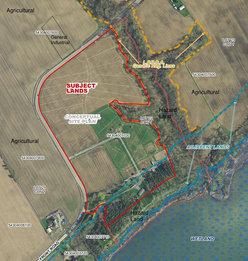
CD 21- 30 Page 2 of 15
Site Features and Land Use:
The lands are approximately 23.6 hectares in area and are located at 436 Front Road,
St. Williams, Norfolk County. The property is outside the urban settlement boundary and
lies between Port Rowan and Booths Harbour. The subject lands have a gradual
descending slope from Front Road toward Lake Erie and a greater slope within the
Significant Woodland area to the east of the property boundary.
‘Agricultural’ Lands predominantly surround the property with a small parcel of General
Industrial (MG) use at the opposite side of Front road. There is a ‘Hazard Land’ zone
with “Significant Woodlands” at the east side, which is extended to the south along Lake
Erie.
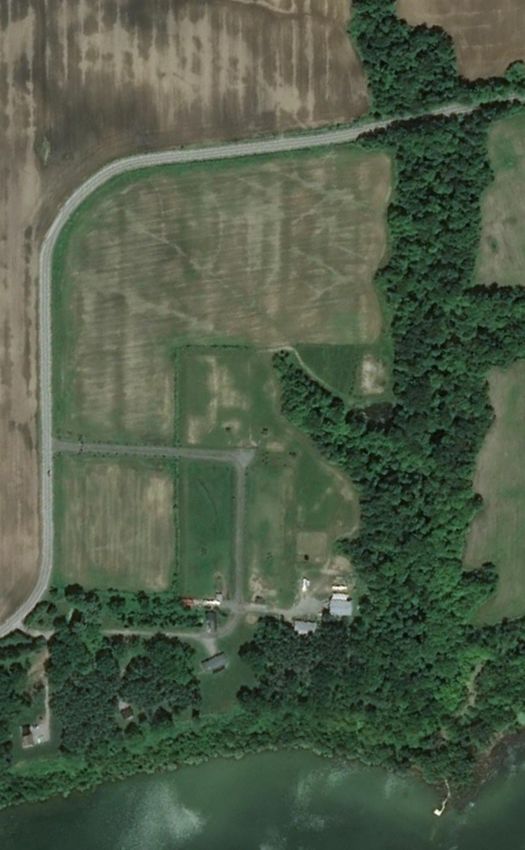
Figure 1: The subject lands and surrounding land-uses.
CD 21- 30                                                                      Page 3 of 15

A portion of the land is currently rented out for cash crops, and the balance of the land
is used as a horse ranch with several dwelling units already located on the site used by
family members.

            Figure 2: The site entrance from Front Road at west side of the property.

The Proposal: The development concept proposes a combination of resort-oriented
condominium development consisting of 23 farm dwelling units (including the existing
primary dwelling) which will share a redeveloped ranch and stable area. To make the
proposal financially viable and to utilize the existing farmland and natural characteristics
of the Lake Shore area, the proposal includes certain functions in the form of ‘On-Farm
Diversified Uses,’ and identified their linkage to Official Plan policies. The proposed ‘On-
Farm Diversified Uses,’ are listed below:

       1. A country style Inn/Tourist Cabins for short term accommodations: a
          secondary use of primary ‘Agricultural’ land;
       2. A commercial indoor and outdoor riding arena: a secondary use of primary
          equestrian activities of the property;
       3. A saloon: to promote local products, food and beverage, integrating local agri-
          food network;
       4. A wedding and conference Centre within the riding arena/stable: to promote
          agri-tourism in the Lakeshore Policy Area.
The concept is unique in nature and heavily influenced by local farmland settings and
the Lakeshore area’s unique natural features. The proposal emphasizes the Lakeshore
Special Policy Area Secondary Plan that supports sustainable tourism and recreational
opportunities within the Plan area to accommodate both tourists and County residents.
The policies identified in the Planning Justification Report dated November, 2020,
prepared by Vallee Consulting Engineers in support of the development include:
CD 21- 30                                                                  Page 4 of 15

       •    Section 11.4.4 that promotes ‘Agri-tourism and Resource-based Tourism’
            uses within the agricultural designated area along Lakeshore Special Policy
            Area (LSPA);

       •    Section 11.6.1.3 related to ‘Unique Tourism Development Proposals’ that
            provides a framework to evaluate and review unique tourism development
            proposals which are not contemplated by the Official Plan within the LSPA
            Agricultural Area;

       •    Section 11.6.3 related to ‘Accommodations’ that supports the provision of
            roofed accommodations within the LSPA to provide overnight
            accommodations to support the County’s tourism and economic development
            objectives.

                             Figure 3: Development Concept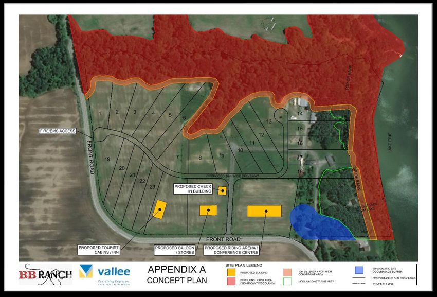
CD 21- 30                                                                    Page 5 of 15

Discussion:

Land-use Compatibility: The subject property is located in a predominantly agricultural
area. The closest dwelling to the subject property is claimed to be the property owner’s
son and who supports the proposed development. The Planning Justification Report
dated November 24, 2020, prepared by G. Douglas Vallee Limited, mentioned two other
dwellings within 200 metres of the subject property. All adjacent dwellings are zoned as
‘Agricultural.’ Significant woodlands also surround the subject property at the east and
south side along the Lakeshore area. A portion of the lands are currently rented out for
cash crops, and the balance of the land is used as a horse ranch and primary residence
of the owner.

The property is located between Port Rowan and Booths Harbour with various tourist
and recreational functions within 1 kilometre, including lifestyle residential
condominiums for retirees and seniors, motor homes, boathouses, marina and various
recreational facilities. The subject lands are also located on the Lake Erie shoreline with
direct access to the Big Creek Circle Cycling Route, Wine Tour Cycling Route and
Waterfront Cycling Route.

Resort-oriented residential condominiums, tourist activities, and agri-tourism are
historically present in the locality. The Planning Justification Report states that the
proposed Farm Condominium Dwelling Units will share the redeveloped ranch and
stable areas. There will be no overall increase in the existing ranch and stable areas.
Planning Staff recommends a consolidation of all On-farm Diversified Use structures to
reduce the physical footprint on agricultural activities and maximize the preservation of
existing cash-crop production, or other possible production opportunities in the future.

New Lot Creation in ‘Agricultural’ Land: Staff believes that creating 23 new lots (as
shown in the concept plan) may need a creative approach to be consistent with PPS
policy 2.3.4.3 and Official Plan policy 7.2.3. As the proposed development will operate
under a condominium corporation, the individual units can still function without creating
separate lot configurations. For the purpose of Official Plan and Zoning applications,
staff suggests exploring the possibility of considering the whole land as one lot under a
full condominium development. Legal advice may be necessary to explore if individual
buildings can be owned by individual owners while sharing other spaces as a common
element. This may eliminate the need for creating separate lots. There are examples of
resort-oriented residential condominium which can be found within one kilometre of the
subject site.

On-farm Diversified Use: Both PPS 2020 and Norfolk County Official Plan encourages
On-farm Diversified Uses under certain conditions. The permitted uses include but are
not limited to home occupations, home industries, agri-tourism uses including overnight
tourist accommodation and uses that produce value-added agricultural products,
including those that use crops from other producers. Different municipalities have minor
deviations on required details, such as the variety of uses and sizes, which is basically
CD 21- 30                                                                    Page 6 of 15

defined by their own municipal context. In addition to PPS 2020 policies, Norfolk Official
Plan and Lakeshore Special Policy Area (LSPA) Secondary Plan also provide direction
and guidelines in more detail about On-farm Diversified Uses. Based on these policies,
the following are planning comments concerning the proposed on-farm diversified uses:

   1. Small-scale roofed and overnight accommodation in the form of an Inn or Group
      Tourist Cabins - consistent with section 7.2.2 b) of the Official Plan and section
      11.4.4 of the LSPA Secondary Plan;
   2. A saloon with food and beverage services: This use can be considered ‘on-farm
      diversified’ provided that locally and on-site produced products are incorporated
      into the services;
   3. A conference centre in the form of a multi-purpose riding arena/stable (barn) to
      host weddings, team-building events and conferences - consistent with section
      7.2.2 b) of the Official Plan and section 11.4.4 of the LSPA Secondary Plan.
The details of the On-farm Diversified Uses can be further reviewed during the
subsequent stage of the planning process. However, the overall size of the On-farm
Diversified Use should be addressed through the zoning by-law amendment. It is also a
point worthy of mentioning that section 7.2.2 ix) of the Official Plan does not permit
severance of land for on-farm diversified uses. On-farm Diversified Use is not intended
for new lot creation; rather, the use is considered an accessory of the existing
agricultural activities.

Minimum Separation Distance (MDS): According to the Planning Justification Report
dated November 24, 2020, prepared by G. Douglas Vallee Limited, the subject property
currently has approximately 262 square metres of stable area. The proposed
development intends to remove the stable facilities and relocate them to newer
structures. When the facilities are replaced, they must be constructed in accordance
with applicable Minimum Distance (MDS) formulae. There are no current or proposed
manure storage facilities for the property as manure will continue to be removed from
the lands.

The stable facilities' new location should be located with a certain distance from lot
lines, road allowance, and other dwelling types and land uses. Given the nature of the
proposal, staff may need input from OMFRA in the calculation of MDS.

Servicing: According to the Planning Justification Report dated November 24, 2020,
prepared by G. Douglas Vallee Limited, private water and sanitary services are
proposed for each individual farm dwelling, Inn or Tourist Cabins, saloon and riding
arena/stable/conference centre/barn. Until such time that a hydro-geological and
geotechnical study is completed, it cannot be determined if private cisterns, potable
water wells, or both are best suited for overall development. Private septic and tile bed
systems are envisioned for each use. The technical details will be reviewed during the
site plan stage, and approval should be conditional upon submission of all technical
reports to the satisfaction of the County.
CD 21- 30                                                                    Page 7 of 15

Traffic: A high-level traffic analysis has been submitted to demonstrate existing and
proposed volumes of traffic based on the development concept. The development
concept shows 23 farm residential dwellings. Based on this proposal, the traffic count
for peak hour on Saturday will be one car in every minute. The on-farm diversified uses
such as the conference centre are event-driven and will occasionally add to the traffic
on Front Road and are not included in this forecast.

According to Planning Justification Report, the volume of current and projected traffic is
low and does not seem to warrant the need for any road improvements. G. Douglas
Vallee Limited provided this basic review on a high-level basis; therefore, it is
recommended that a full traffic impact study be submitted by a qualified professional
with a future site plan application.

Technical Studies: Further to the overall Planning Justification Report which provides
initial Technical Overviews, the applicant is aware that there are requirements for full
assessment reports which will be required to ensure technical details are addressed
appropriately. A high level overview of the following reports have been included with
the Planning Justification Report. Some items, such as Agricultural Impact and
Environmental Impact, may require more assessment and justification prior to any land
use decision and others will need more detailed assessment at subsequent stages of
the planning process.

       1) Agricultural Impact Assessment, - to mitigate the impacts of any non-
       agricultural uses on agricultural operations.
       2) Environmental Impact Study – to mitigate and/or protect any identified
       sensitive features;
       3) Full Traffic Study
       4) Geotechnical Report and Slope Stability analysis/erosion analysis
       5) Functional Servicing Report
       6) Stormwater Management Report
       7) Archaeological Report

A holding provision may be necessary as part of the zoning amendment to ensure that
further technical study and analysis is reviewed to the satisfaction of the County during
the next stages of the planning process, and an appropriate development agreement is
registered on title.

Site plan control: In accordance with Section 41 of the Planning Act and Site Plan
Control By-law 2014-97, the proposed development will be required to go through a site
plan application process to ensure County’s development standards are maintained
through the establishment of a site plan agreement.

Circulation Comments:
The technical comments received from departments and agencies to date are attached
within Appendix A and form part of this Statutory Public Meeting report. Comments from
the Ministry of Municipal Affairs and Housing (MMAH) are still pending and will be
CD 21- 30                                                                     Page 8 of 15

provided to the applicant as soon as received and presented in the future report once
received. Key technical comments from Staff and Agencies include:

   1. Detailed information in relation to Minimum distance separation (MDS)
      calculations;
   2. Consolidation of all On-farm diversified uses to minimize the overall lot coverage
      area;
   3. Confirmation of the development away from Hazard lands;
   4. Alternative approach to define the condominium development without creating 23
      lots;
   5. Confirmation of new location for the stable and barn; and
   6. Requirement of Functional Servicing report and Traffic Impact Study.

Regard For Public Input:
No formal public input has been received for this application. This report is being
presented as part of the statutory public meeting, and any public comments will be
considered for future recommendation.

Planning Considerations:

It is owner’s responsibility to be aware of and comply with all relevant federal or
provincial legislation, municipal by-laws or other agency approvals.

Provincial Policy Statement, 2020

The PPS was issued under Section 3 of the Planning Act and the current PPS (2020)
came into effect on May 1, 2020. In this regard, Section 3 of the Planning Act requires
that land use planning decisions “be consistent” with the PPS.

Section 2.3.4 related to ‘Lot Creation and Lot Adjustments’ states that the creation of
new residential lots in prime agricultural areas shall not be permitted, except for surplus
dwellings in an active farm operation.

Planning Comments: Staff believes that creating 23 new lots (as shown in the concept
plan) may need a creative approach to be consistent with policy 2.3.4.3. Planning Staff
will work with the Applicant to identify an alternative approach to address the PPS policy
directions.

Policy 2.3.6 related to ‘Non-Agricultural Uses in Prime Agricultural Areas’ states that
Planning authorities may only permit non-agricultural uses in prime agricultural areas
with certain conditions including:

   1. the land does not comprise a specialty crop area;
   2. the proposed use complies with the minimum distance separation formulae;
CD 21- 30 Page 9 of 15
3. there is an identified need within the planning horizon provided for in policy 1.1.2
for additional land to be designated to accommodate the proposed use; and
alternative locations have been evaluated, and
I. there are no reasonable alternative locations which avoid prime agricultural
areas; and
II. there are no reasonable alternative locations in prime agricultural areas with
lower priority agricultural lands.
Planning Comments: The proposed development will be further reviewed to conform
to the above-noted conditions for non-agricultural uses in prime agricultural lands.
Note: Endangered and threatened species and their habitat are protected under the
provinces Endangered Species Act, 2007 (ESA). The Act prohibits development or site
alteration within areas of significant habitat for endangered or threatened species
without demonstrating that no negative impacts will occur. Ministry of Environment,
Conservation and Parks (MECP) provides the service of responding to species at risk
information requests and project screenings. The applicant is advised to discuss the
proposed activity and have their project screened with MECP by contacting at
SAROntario@ontario.ca.
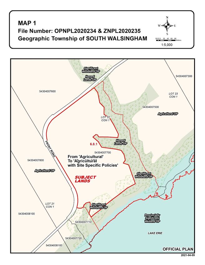
Norfolk County Official Plan
The subject lands are designated as ‘Agricultural’ and ‘Hazard Lands’ in the Official
Plan. A small part of the land is designated as Provincially Significant Wetland along
Lake Erie Shoreline. There is also a strip of significant woodlands along east and south
property line near the water edge. The subject lands are within the Lakeshore Special
Policy Area as per Schedule A-1 of the Official Plan. Appendix B of the secondary plan
identified the subject lands mostly as medium agricultural priority.
Figure 4: Agricultural
Priority in Appendix B of
the LSPA Secondary
Plan.
Section 7.2.2, related to ‘Agricultural Designation’ provides direction on ‘On-farm
Diversified Use’. Section 7.2.2 b) states, “the use may include, but is not limited to,
home occupations, home industries, agri-tourism uses including overnight tourist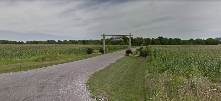
CD 21- 30                                                                    Page 10 of 15

accommodation and uses that produce value-added agricultural products, including
those that use crops from other producers.”

Section 7.2.2 also states, “the use is compatible with, and will not hinder, surrounding
agricultural operations;” and “severances to separate the on-farm diversified uses from
the farm property will not be permitted.”

Section 7.2.2, also states that limited non-agricultural uses may be permitted in the
Agricultural Designation provided that certain policies are met including condition that
the use shall be located on lower priority agricultural land unless it has been
demonstrated that there are no reasonable alternative locations that avoid the use of
prime agricultural lands.

Planning Comment: The development proposal will be tested through the policies of
Section 7.2.2 to determine the permissibility of the proposed development from a land-
use perspective. This will be further analyzed during the recommendation report.

Significant woodlands are located on the subject lands, and are considered to be a
Natural Heritage Feature. Section 3.5.2 b) states, “Development or site alteration
proposed in, or adjacent to, a Natural Heritage Feature(s), shall be subject to the
completion of an Environmental Impact Study. Development or site alteration in, or
adjacent to, such features shall not be permitted unless it has been demonstrated that
there will be no negative impacts on the natural features or on their ecological functions
that cannot be adequately mitigated.

Planning Comment: Planning Staff will further work with the applicant to ensure that
that no developments are proposed within the Significant Woodlands or Hazard Lands
area. A Full Environment Impact Assessment will be required during the subsequent
stage of the planning process to the County's satisfaction.

Section 7.3.2 – Hazard Lands Policies states, “Development on Hazard Lands which
would aggravate or contribute to the hazard shall not be permitted”. The County’s policy
on Hazard Lands is that new development should only occur in areas that are not
susceptible to hazards.

Planning Comment: The Applicant is working with LPRCA and the County Staff to
identify the development limit considering the Hazard Land Zone and LPRCA regulated
buffer from the Top of the Slope.

Lakeshore Special Policy Area (LSPA) Secondary Plan

Section 11.4 related to Agricultural Strategy outlines a sustainable approach to
protecting the County’s agricultural resources while promoting the long-term economic
viability of agricultural operations.
CD 21- 30                                                                  Page 11 of 15

When evaluating proposals for non-agriculture uses in the LSPA Agricultural Area, this
kind of development shall be directed to lower priority agricultural land.

Planning Comments: The subject lands are within medium priority agricultural land as
shown on Appendix “B” of the plan. According to PPS policy direction, the applicant will
provide justification that alternate locations have been evaluated.

In recognition of the unique agri-tourism and resource based tourism uses associated
with the lakeshore, such uses are promoted in accordance with the policies of Section
11.4.4 (Agri-Tourism and Resource Based Tourism Uses) of this Plan. In addition to the
uses permitted within the Agricultural Designation in Section 4.2 (Agricultural
Designation) of LPSA, the following additional secondary uses shall be permitted:

   1. small inns, which shall be defined as roofed accommodations with 8 guest rooms
      or less;
   2. restaurants, directly associated with a winery, agri-tourism or resource-based
      tourism use;
   3. retail stores, directly associated with a winery, agri-tourism or resource-based
      tourism use; and
   4. banquet and conference centres, directly associated with a winery, agri-tourism
      or resource-based tourism use;

Planning Comments: In section 11.4.4 Resource-Based Tourism is considered as a
secondary use. It is understood that the site-specific Official Plan and Zoning By-law
Amendment will allow the proposed resource-based tourism, including Inn or Tourist
Cabins as secondary use. A site-specific Zoning By-law amendment will establish site-
specific development parameters related to gross floor area, number of rooms or seats,
height, setbacks and massing, among other matters.

Section 11.6.1.3 related to ‘Unique Tourism Development Proposals’ provides a
framework to evaluate development proposals that are not contemplated by the Official
Plan within the LSPA Agricultural Area. The secondary plan states that such unique
tourism development proposals cannot be anticipated by the Official Plan given their
unique market and locational characteristics. The LSPA also states that in such cases,
an Official Plan amendment will be required and a comprehensive review of the LSPA
secondary Plan may be required if further amendment is essential to this document,
Key development criteria for assessing such unique proposal includes:

   •   the use shall be located adjacent to an Urban Area, Hamlet Area or Resort Area;
   •   the use shall have frontage on to, or is adequately accessible from Ontario’s
       South Coast Scenic Route;
   •   there shall be a demonstrated basis and need for the proposed use;
   •   the use shall be located on land that do not comprise specialty crop land;
   •   the use shall be located on lower priority agricultural land in accordance with
       Section 11.4.2 (Priority Agricultural Land), when possible;
CD 21- 30 Page 12 of 15
• the use shall be located in an area where there will be little or no impact on
agriculture;
• the use shall protect and enhance the areas significant natural features, cultural
resources and views;
• the use shall comply with the Minimum Distance Separation Formulae;
• the use shall be located on an arterial or collector road;
• the use shall not be permitted in Provincially Significant Features and Hazard
Lands,
Planning Comments: The above mentioned development criteria will be further
reviewed and utilized to assess the various components of the proposal. A conformity
check will be provided within the future recommendation report.
Norfolk County Zoning By-Law 1-Z-2014
As per Schedule A-12 to the Zoning By-law of Norfolk County 1-Z-2014 (the “Zoning By-
law”), the subject lands are zoned as Agricultural (A), Hazard Land (HL) and Provincially
Significant Wetland Zone (PSW).Zones. It is apparent that no modification of Hazard
Lands (HL) and PSW will be required. Special provisions are proposed to permit certain
non-agricultural and On-farm Diversified Uses.
Agricultural (A) Zone
Section 12.1 of the Zoning By-law outlines the zoning provisions for lands zoned ‘A’.
The permitted uses within the ‘A’ zone include animal kennels, bed and breakfasts,
cannabis production and processing, single-detached dwellings, farms and farm
associated uses. Based on these permitted uses, the subject lands' current zoning does
not permit the proposed resort oriented residential condominium and other on-farm
diversified uses. As such, a zoning by-law amendment is required to permit the
proposed development.
A Special Provision with the current ‘Agricultural’ zone is required to permit the following
uses:
1. 23 Resort Farm Condominium Dwelling Units;
2. The conference centre with the riding arena (barn) and wedding function to a
height of 20 metres. The size and parking numbers to be determined;
3. An Inn or Tourist Cabins with maximum 8 beds. The area and parking numbers
to be determined;
4. A saloon with food and beverage services. The area and parking numbers to be
determined;
5. Amendments of 12.3 related to on-farm diversified uses as appropriate.CD 21- 30 Page 13 of 15
Strategic Plan Linkage:
This report aligns with the 2019-2022 Council Strategic Priorities "Foster Vibrant,
Creative Communities" and "Create an Optimal Place for Business”.
Explanation: The proposed development will facilitate and promote resource-based
tourism with natural heritage and recreational facilities and contribute to alternative
overnight accommodation, agri-tourism and agri-food network.
Conclusion: The purpose of this report is to summarize the planning application
proposal, provide the comments received from applicable departments and agencies,
summarize comments received from member of the public, and to provide general
information in relation to the overall application. A staff report with related
recommendations will be submitted to Council for consideration at a later date.
Recommendation(s):
That Report CD 21-30, Public Hearing report for OPNPL2020234 and ZNPL2020235 be
received for information;
THAT any outstanding technical comments and requirements necessary prior to
bringing forward a recommendation report be addressed;
AND THAT any comments received as part of the statutory public meeting be
considered in a future recommendation staff report.
Attachment(s):
Maps 1 to 2
Appendix A Circulation Comments
Appendix B Concept Plan
Appendix C Planning Justification Report dated November 24, 2020, prepared by G.
Douglas Vallee Limited
Submitted By:
Brandon Sloan, BES, MCIP, RPP Reviewed By:
General Manager Tricia Givens, M.Sc.(PL), MCIP, RPP
Community Development Division Director of Planning
185 Robinson Street Community Development Division
Simcoe, Ontario, Canada, N3Y 5L6 185 Robinson Street
519-426-5870 ext. 1348 Simcoe, Ontario, Canada, N3Y 5L6
519-426-5870 ext. 1893
Prepared By:
Mohammad Alam, MPL, MUD, MCIP, RPP
Senior Planner
Community Development Division
519-426-5870 x. 1828CD 21- 30 Page 14 of 15
CD 21- 30 Page 15 of 15
Appendix A

Circulation Comments

Note: Staff may provide additional comments during the review process and as new
information becomes available.

Finance

Reviewed - This application would have a positive impact on assessment growth and
tax revenues. The amount of growth is dependent on the assessment of the property by
the Municipal Property Assessment Corporation (MPAC). Norfolk County would also
receive Development Charges in accordance with the most recent Development
Charges By-law. However it should be noted that the current By-Law provides an
exemption for roofed accommodations. The cost of this exemption would be funded by
the levy.

Development Agreement Administrator

Reviewed - Recommend that a Holding (H) Provision be added to the lands and remain
in place until a development agreement has been executed and registered on title.

Building Department

Reviewed – No Comment.

Fire and Rescue Services

Reviewed - The Fire Department has no concerns with this rezoning proposal.

Geographic Information Systems Services

Reviewed - No Comment.

Development Engineering

Reviewed:

1. As per Development Engineering’s Pre-Consultation Meeting Minutes, a Functional
Servicing Report (FSR) as per Norfolk County Design Criteria is required at OPA/ZBA
stage.
2. As per Development Engineering’s Pre-Consultation Meeting Minutes, a Traffic
Impact Study (TIS) completed to Norfolk County’s ISMP – Appendix J: TIS Guidelines is
required at OPA/ZBA stage.
3. If the applicant’s intent is to connect to the municipal watermain, water modelling will
be required.
Long Point Conservation Authority

Reviewed:

Comments for Council Report:
Long Point Region Conservation Authority staff have reviewed the above-noted
application as part of the Official Plan and Zoning By-law amendment affecting 436
Front Road in St. Williams, Norfolk County.

The subject lands are prone to flooding and erosion from Lake Erie and flooding and
erosion from a watercourse draining into Lake Erie. The lands also contain and are
located adjacent to Provincially Significant Wetlands.

Delegated Responsibility from the Ministry of Natural Resources and Forestry,
Section 3.1 of the Provincial Policy Statement, 2020
Conservation Authorities have been delegated responsibilities from the Minister of
Natural Resources and Forestry to represent the provincial interests regarding natural
hazards encompassed by Section 3.1 of the Provincial Policy Statement, 2020 (PPS).
The overall intent of Section 3.0 - Protecting Public Health and Safety of the PPS is to
reduce the potential public cost or risk to Ontario’s residents from natural or human-
made hazards.

Section 3.1.1 of the Provincial Policy Statement states that “Development shall be
generally directed to areas outside of:

    a) Hazardous lands adjacent to the shorelines of the Great- Lakes – St. Lawrence
       Rive Systems and large inlands lakes which are impacted by flooding hazards,
       erosion hazards, and/or dynamic beach hazards,
    b) Hazardous lands adjacent to river, stream and small inland lake systems which
       are impacted by flooding hazards and/or erosion hazards.”

The east side of the proposed development contains a watercourse and the associated
ravine that is subject to flooding and erosion. The development lot lines should reflect a
setback that accounts for toe erosion (typically 15 meters, unless further investigated)
plus stable slope allowance (3 times the height of the slope measure land-ward from the
toe erosion allowance, or determined through a valid study) plus a 6 meter erosion
access allowance.

The south side of the proposed development contains a slope that is approximately 21
meters high. The development lot lines should reflect a setback that accounts for
erosion of the shoreline, estimated to be approximately 0.3 metres/year plus a stable
slope allowance (3 times the height of the slope measure land-ward from the toe) plus a
6 meter erosion access allowance.

Community Development Division, Planning Department, Norfolk County, Page 2 |
If any geotechnical investigations are to be undertaken relating to the ravine or
shoreline slopes, the proponents are encouraged to contact LPRCA to scope the level
of review required.
Provided all development (dwelling, accessory buildings, septic systems, etc.) can be
located outside of the erosion hazards as outlined above, LPRCA has no concerns as it
relates to section 3.1 of the Provincial Policy Statement.
Stormwater Management
LPRCA technical staff will review the Functional Servicing Report and Stormwater
Management Report when available.
Ontario Regulation 178/06
A portion of the subject lands area located within the Regulated Area as described in
Ontario Regulation 178/06. Any development as defined in the Conservation Authority
Act proposed within this area requires permission prior to development occurring.
Zoning Administrator
Reviewed:
1. Zoning table for each use on property needs to be provided
2. Parking needs to be provided on site (parking lot layout)
3. Attached MDS needs to be confirmed it is met by providing a site plan
4. Location of where horses are being housed needs to be indicated (i.e. riding
arena, separate barn)
5. Setbacks to property lines need to be provided for proposed buildings
6. Building heights, elevations need to be provided
7. Tourist cabins need to meet building code standards or if modular home/ trailer
being used need to meet CSA A277 or CSA Z240 structural
8. Suggest zone change to Open Space or Open Space Tent and Trailer instead of
on-farm diversification. Riding arena could be classified as “place of sports and
recreation”.
Ministry of Municipal Affairs and Housing ‘One Window Service’
Reviewed:
Thank you for circulating Official Plan and Zoning By-law Amendment Applications
OPNPL2020234/ ZNPL202023 to the Ministry of Municipal Affairs and Housing. This
matter was further circulated through the One Window Planning Service to the Ministry
of Agriculture, Food, and Rural Affairs (OMAFRA), the Ministry of Natural Resources
and Forestry (MNRF), and the Ministry of the Environment, Conservation and Parks
(MECP). It is recognized that the official plan amendment (OPA) is exempt from the
Minister’s approval and the following One Window comments are provided to the
County for its consideration in making decisions on these matters.
Community Development Division, Planning Department, Norfolk County, Page 3 |The subject lands are located at 436 Front Road in the Township of South Walsingham, Norfolk County. The subject lands are designated Agricultural in the Norfolk County Official Plan and are part of the Agricultural Area in the Lakeshore Special Policy Area. The OPA proposes a site-specific policy to permit the development of a multi-purpose resort facility including a wedding and conference centre, horse riding arena, saloon, inn and tourist cabins, and 27 single-detached residential condominium dwellings. It should be noted that condominium development constitutes lot creation for the purposes of the PPS. The subject site is prime agricultural land with a Canada Land Inventory (CLI) class 2 soil classification and is part of the prime agricultural area. Consideration has been given to this matter in terms of the criteria and policies of the Provincial Policy Statement, 2020 (PPS).The following comments identify matters that the County should consider in its review of the application including matters where additional information may be needed from the applicant to demonstrate consistency with provincial policy. The PPS permits agricultural uses, agriculture-related uses and on-farm diversified uses in the prime agricultural area (2.3.3.1). Non-residential uses are permitted in limited instances subject to several criteria including evaluating alternative locations to avoid prime agricultural areas and mitigating the impacts of any new or expanding non- agricultural uses on surrounding agricultural operations (2.3.6). No information has been provided to demonstrate that mitigation was considered. The County should review the OPA to determine if the proposed uses are permitted in the prime agricultural area. The County is also encouraged to request an Agricultural Impact Assessment to ensure sufficient planning justification has been provided about mitigating the impacts of non- agricultural uses on agricultural operations. The PPS does not allow the creation of new residential lots in prime agricultural areas, with the exception of a residence surplus to a farming operation (2.3.4.1, 2.3.4.3). The proposed OPA would allow for the development of a 27 lot residential condominium development, which constitutes lot creation for the purposes of the PPS. The County is encouraged to review whether the residential development that could result from this OPA is consistent with the PPS. PPS policies 2.3.6.1 b) and 2.3.3.3 require compliance with Minimum Distance Separation (MDS) formulae when considering non-agricultural uses and lot creation in prime agricultural areas. Policy 2.3.6.2 identifies that impacts from new or expanding non-agricultural uses on surrounding agricultural operations and lands should be mitigated to the extent feasible, which is supported by compliance with the MDS formulae. While the MDS formulae is shown in the Planning Justification Report, limited information is provided to demonstrate that the MDS Implementation Guidelines were used to support this MDS evaluation. The County is encouraged to review the MDS calculations provided by the applicant to ensure compliance with the MDS formulae. The MDS Implementation Guidelines should be considered in this review including Guidelines 16 and 40. Section 1.6.6 of the PPS provides direction on servicing, including servicing requirements for the creation of new lots (1.6.6.6). No information has been provided to demonstrate how the proposed development would be serviced. In order to ensure that the proposal is consistent with the policies in section 1.6.6, the County should request a Community Development Division, Planning Department, Norfolk County, Page 4 |
servicing strategy from the applicant. MECP approval of the sanitary servicing will be
required if any use exceeds 10,000 liters a day.

The subject site contains a significant woodland. The PPS does not allow development
in significant woodlands or on adjacent lands unless it has been demonstrated there are
no negative impacts on the natural features or their ecological function (2.1.5, 2.1.8).
The County should request a scoped Environmental Impact Study identifying the
potential impacts on the natural features to inform its review of the application.

The following background documents may assist the County’s review of this application:
       • OMAFRA’s ‘Guidelines on Permitted Uses in Ontario’s Prime Agricultural Areas’
       (http://www.omafra.gov.on.ca/english/landuse/permitteduses.htm)
       • OMAFRA's draft ‘Guidance Document for Agricultural Impact Assessments’
       (http://www.omafra.gov.on.ca/english/landuse/aia.htm).

Community Development Division, Planning Department, Norfolk County, Page 5 |
BANK
TOP OF
1 2 3 4 14
5
TOP OF BANK
6
13
FIRE/EMS ACCESS
15
LAKE ERIE
12
FRONT RO
11 16
10
7 8 9 17
19
TOP
20
AD
18
21
OF B
PROPOSED 10m WIDE DRIVEWAY
22
ANK
23 PROPOSED CHECK
IN BUILDING
E T B A CK
S
91.5m L AKE
FR O M
FRONT ROAD
PROPOSED TOURIST PROPOSED SALOON PROPOSED RIDING ARENA /
CABINS / INN / STORES CONFERENCE CENTRE
SITE PLAN LEGEND
APPENDIX A PROPOSED BUILDING 10m SETBACK FROM HIGH
CONSTRAINT AREA
30m AQUATIC SAR
OCCURRENCE BUFFER
PROPOSED LOT AND ROAD LINES
CONCEPT PLAN HIGH CONSTRAINT AREA
(SIGNIFICANT WOODLAND)
MEDIUM CONSTRAINT AREA
PROPERTY LINENovember 24, 2020
County of Norfolk
Robinson Administration Building
185 Robinson Street, Suite 200
Simcoe, ON N3Y 5L6
Attention: Mohammad Alam, Senior Planner
Reference: Planning Justification Report - BB Ranch
G. Douglas Vallee Limited on behalf of BB Investments Ltd.
436 Front Rd, South Walsingham, Norfolk County
Roll # 3310 543 040 07700
Our Project 10-094
Introduction:
G. Douglas Vallee Limited has been retained by Jeff Bouck of BB Investments Ltd. to make application
for an Official Plan and Zoning By-law Amendment to permit a mulit-purpose Horse Riding
Arena/Stable/Wedding and Conference Centre (Barn), Saloon, Resort Oriented Residential
Condominium, and Inn/Tourist Cabins on the property located at 436 Front Road in St. Williams, Norfolk
County.
It is proposed to add a special policy to the Agricultural Designation of the Official Plan and Lakeshore
Special Policy Area Secondary Plan and a special exception to the Agricultural Zone of the Zoning By-
law to permit the uses and modifications to zone provisions. If the land use concept is approved,
subsequent development applications such as a site plan, removal of holding and condominium
exemption along with supporting studies will be required to be submitted and subject to the review and
approval by the County.
This application does:
• Establish a unique resort-oriented • Comply with the general intent and
development based on the primary land purpose of the Lakeshore Special Policy
use of horse ranching and horseback Secondary Plan.
riding. • Maintain consistency with the intent of
• Provide a unique tourist destination with the Provincial Policy Statement 2020.
overnight and roofed accommodation. • Add to the mix of housing types
• Facilitate visitor attendance to local area established in the County.
marine and commercial businesses be • Generate an acceptable level of traffic.
providing accommodations within close • Utilize private servicing infrastructure
proximity. and do not create adverse affects on the
• Avoid consumption of production crop County water and sanitary sewer
lands. systems.
• Avoid impacts on surrounding lands. • Protect existing significant woodlands.
• Comply with the general intent and • Avoid hazard lands.
purpose of the Norfolk County Official • Represent good planning.
Plan.
2 Talbot Street North, Simcoe, ON N3Y 3W4 Phone: 519 426-6270 Fax: 519 426-6277 www.gdvallee.ca
G. Douglas Vallee LimitedBB Investments Ltd. Official Plan and Zoning By-law Amendment
436 Front Road, St. Williams, Norfolk County
Our Project 10-094 Page 2
Purpose:
The purpose of this Planning Justification Report is to provide planning support and information to the
County to consider when reviewing the proposed applications for an Official Plan and Zoning By-law
amendment. Specifically, it is proposed to permit a horse ranch in the form of a resort with the following
uses:
a) Saloon (dining); d) A wedding and conference centre within
b) A country style Inn/Tourist Cabins for the Riding Arena/stable; and
short term accommodations; e) Resort oriented residential
c) An indoor riding arena and outdoor condominium dwelling lots.
riding area;
There is an existing residence on the subject property which is intended to be replaced with a new
single detached dwelling and function as the owners primary dwelling.
Site Description:
The lands are approximately 23.6 hectares in area and are located at 436 Front Road, St. Williams,
Norfolk County. The property is outside the urban settlement boundary and lies between Port Rowan
and Booths Harbour. The topography of the development area has a gradual descending slope from
Front Road toward Lake Erie and a greater slope within the Significant Woodland area to the east of
the property boundary.
A portion of the lands is currently rented out for cash crops and the balance of the lands is used as a
horse ranch and primary residence of the owner. The significant woodland feature remains intact with
the exception of an overgrown spruce plantation where the trees are generally in poor health and would
pose a hazard to any adjacent development and therefore should be removed.
The lands are nestled on the Lake Erie shoreline with direct access to the Big Creek Circle Cycling
Route, Wine Tour Cycling Route and Waterfront Cycling Route.
Currently, a single driveway serves as the main access to the property and dwelling. An existing culvert
exists on Front Road along the northerly property line which provides access to large farm vehicles
currently cultivating and harvesting the lands. Figure 1 represents an aerial image of the subject lands
and describes its configuration considering the current uses, woodland features and the Lake Erie
shoreline.
Figure 2 represents a development concept plan showing the resort oriented condominium lots,
driveway access, proposed saloon, riding arena/conference centre (barn) and Inn/Tourist Cabins. It
also demonstrates the natural feature areas, protected lands, buffer areas, the lakeshore of Lake Erie
and Front Road.
G. DOUGLAS VALLEE LIMITED
Consulting Engineers, Architects & Planners
Authorized by the Association of Professional Engineers of OntarioBB Investments Ltd. Official Plan and Zoning By-law Amendment
436 Front Road, St. Williams, Norfolk County
Our Project 10-094 Page 3
Background and surrounding uses:
The subject lands are approximately 23.6 hectares in area and have traditionally been used for a horse
ranch and the growing and harvesting of cash crops. The proposed development lands appear to have
been vacant with the exception for some open storage associated with farming activities according to
1964 Aerial photography. Surrounding land uses are agricultural with limited residential dwellings in
closer proximity.
Figure 1: Subject Lands
G. DOUGLAS VALLEE LIMITED
Consulting Engineers, Architects & Planners
Authorized by the Association of Professional Engineers of Ontario
to offer professional engineering services.BB Investments Ltd. Official Plan and Zoning By-law Amendment
436 Front Road, St. Williams, Norfolk County
Our Project 10-094 Page 4
Figure 2:
Supporting Information:
Supporting information has been prepared and submitted with the applications including:
• Opportunities and Constraints Analysis (prepared by GeoProcess Research Associates, dated
October 9, 2020)
This analysis was completed to assess the opportunities and constraints of the subject lands to
ensure protection of the woodland, natural heritage and living land and aquatic species in the
area. The concept plan was developed to completely avoid development within these areas
and their buffers. The anticipated site plan approval application will include a full Environmental
Impact Study to examine these areas in detail and identify any areas that may contribute to the
developable area without causing any impacts on these features.
• Agricultural Impact Assessment (AIA)
A high-level agricultural impact assessment has been included in this Planning Justification
Report to demonstrate efficient use of agricultural lands, preservation of crop lands and policy
conformity. Pending approval of this application from the County, an AIA may be prepared by
an expert as part of the site plan approval process, if necessary
G. DOUGLAS VALLEE LIMITED
Consulting Engineers, Architects & Planners
Authorized by the Association of Professional Engineers of Ontario
to offer professional engineering services.BB Investments Ltd. Official Plan and Zoning By-law Amendment
436 Front Road, St. Williams, Norfolk County
Our Project 10-094 Page 5
Environmental Opportunities and Constraints
GeoProcess Research Associates have prepared an Environmental Opportunities and Constraints
Analysis to identify areas where development of the subject lands can occur, areas where development
cannot occur and areas where further study would be required in order to enhance the developable
area while continuing to protect natural heritage features ecological and hydrologic functions, species
at risk and their associated habitats. Figure 2 shows the development concept, unconstrained by
regulated areas. As stated in this report,
“The analysis considers federal, provincial, conservation authority and local municipal/county
policies associated with natural heritage features and any additional requirements such as
setbacks or permits.”
The analysis identifies that if development is to occur within any of the following setbacks, an
Environmental Impact Study will be required:
a) Any development proposed within the LPRCA regulated area;
b) Any development proposing a reduction in the natural heritage setbacks as identified by the
Norfolk County Official Plan;
c) A LPRCA regulated watercourse subject to a non-developable setback of 15 m at the top of
bank. (Top of bank staking will be established through a future EIS);
d) Significant Woodland established at dripline plus 10 metres. (Dripline staking will be
established through a future EIS);
e) A 30 metre buffer to a small watercourse located towards the south-westly portion of the
property; and
f) A 120 metre setback to the LPRCA regulated wetland area.
The proposed development plan has been designed to avoid any of these area list above. This
approach has placed the protection of the natural environment at the forefront of the development
review process and demonstrates that the development outside of these setbacks will have no
significant impact on the natural features and their ecological and hydrologic functions. Based on the
analysis provided by GeoProcess, the overall net developable area of the Study Area is approximately
14.2 to 15.4 ha.
Further study in the form of an Environmental Impact Study will be required to be submitted with a future
site plan application to:
a) Establish driplines to the woodland feature;
b) Establish top of bank for a stable slope adjacent to a watercourse (this can be refined through
a Geotechnical Investigation, if necessary);
c) Consider where potential reductions to the natural heritage setbacks may occur by
addressing natural heritage features including Significant Woodlands, Significant Wetlands,
Fish Habitat and Erosion Hazards; and
d) Demonstrate that proposed development within setbacks or the LPRCA regulated area has
no negative impacts on the natural features or on their ecological functions.
G. DOUGLAS VALLEE LIMITED
Consulting Engineers, Architects & Planners
Authorized by the Association of Professional Engineers of Ontario
to offer professional engineering services.BB Investments Ltd. Official Plan and Zoning By-law Amendment
436 Front Road, St. Williams, Norfolk County
Our Project 10-094 Page 6
The proposed concept plan for the development does not encroach into any environmental setbacks or
the LPRCA regulated area. Accordingly, the proposed development is suitable for the subject lands
from an environmental perspective considering the policies of the PPS, County Official Plan and
LPRCA.
Future supporting studies will be prepared and submitted for County review pending a positive decision
by Council for the proposed Official Plan, Secondary Plan and Zoning By-law amendments. As
indicated in the County pre-consultation meeting comments, the following will be provided at the site
plan application stage:
1) Agricultural Impact Assessment, if 5) Geotechnical Report and Slope Stability
necessary analysis/erosion analysis
2) Environmental Impact Study 6) Functional Servicing Report
3) Archaeological Assessment 7) Stormwater Management Report
4) Traffic Study 8) Water modelling (if connection to
municipal water is proposed)
Appendices to this report include the following:
Appendix A – Draft Concept Plan
Appendix B – Provincial Policy Statement 2020 Policy Compliance
Appendix C – Norfolk County Official Plan Policy Compliance
Appendix D – Lakeshore Secondary Plan Area Policy Compliance
Appendix E – Minimum Distance Separation Calculations
Appendix F – Traffic Information (Photo’s)
This application was submitted to include the information and material required under Section 22(4) and
34 (10.1) of the Planning Act as part of a complete application.
Planning Applications:
Official Plan Amendment
The lands are designated Agricultural, Significant Woodlands and Hazard Lands in accordance with the
Official Plan. The proposed resort development generally complies with the County Official Plan;
however, amendments are required as follows:
1) Modify the existing Agricultural designation to add a site-specific policy to permit:
a. Multiple resort oriented roofed and overnight accommodation in the form of a primary
farm dwelling unit condominium;
b. On-farm diversified uses including:
i. A saloon with food and beverage services; and
ii. Small-scale roofed and overnight accommodation in the form of an Inn or Group
Tourist Cabins; and
iii. A conference centre in the form of a multi-purpose riding arena/stable (barn), to
host weddings, team building events and conferences.
G. DOUGLAS VALLEE LIMITED
Consulting Engineers, Architects & Planners
Authorized by the Association of Professional Engineers of Ontario
to offer professional engineering services.BB Investments Ltd. Official Plan and Zoning By-law Amendment
436 Front Road, St. Williams, Norfolk County
Our Project 10-094 Page 7
2) Modify the existing Hazard Land designation limits based on a future Environmental Impact
Study and a future Geotechnical Study, if required;
3) Modify the existing Significant Woodlands designation based on a future Environmental Impact
Study and a future Geotechnical Study, if required.
4) Site specifically amend Section 7.2.2 c) to allow resort oriented on-farm diversified uses and
exemptions to size limitation policies.
Lakeshore Special Policy Area Secondary Plan Amendment
The lands are designated as a Natural Heritage Area in accordance with Schedule “F” of the Lakeshore
Special Policy Area Secondary Plan (Lakeshore Secondary Plan). The schedule also identifies that the
lands are adjacent to a conceptual Secondary Tourism Node. Schedule G-2 identifies the lands as
Stopover Habitat Study area and Unevaluated Small Forest Patches Study area. The lands closest to
the shoreline appear to included in the Important Bird Study Area of the Long Point Peninsula and
Marshes area; however, the area for development is generally located outside of the bird study area.
An Environmental Impact Study will be prepared in consultation with the County and Long Point Region
Conservation Authority to scope the study appropriately. Appendix B of the Lakeshore Secondary Plan
identifies the lands primarily as medium priority soils. The proposed resort development generally
complies with the Lakeshore Secondary Plan; however, amendments are required as follows:
1) Amend Section 11.4.4 a) ii. to increase the number of guest rooms in the proposed Inn or
grouped Tourist Cabins to greater than 8 pending completion of supporting studies to confirm
suitability for on-site water and waste water control;
2) Amend Section 11.4.4 c) v. and 11.6.1.3 a) v. to allow for development on medium priority soils;
and,
3) Amend Section 11.4.4 c) x. and 11.6.1.3 a) xi. to permit the development on a local road rather
than an arterial or collector road.
Zoning By-law Amendment
The lands are primarily zoned Agricultural Zone (A) in accordance with the County Zoning By-law. The
lands are also subject to a Hazard Land Zone (HL) and Provincially Significant Wetland Zone (PSW).
No modifications to the PSW lands are proposed. Modifications to the Hazard Land zone are proposed,
subject to refinement through a future Environmental Impact Study, if required.
The proposed resort development generally complies with the Agricultural Zone; however, amendments
are required as follows:
1) To amend Section 12.1.1 to permit the resort list of uses to include: Resort oriented primary
farm dwellings (Single detached dwellings) in the form of a condominium; an Inn or Tourist
Cabins, a wedding and conference centre use within the multi-purpose riding arena/stable, and
a saloon.
2) To site specifically amend land use schedule A-11 to permit the development concept subject
to the completion and approval of an EIS to refine natural and protected environmental features
on the subject property.
3) To amend Section 12.3 on-farm diversified uses to remove 12.3 c) through f).
G. DOUGLAS VALLEE LIMITED
Consulting Engineers, Architects & Planners
Authorized by the Association of Professional Engineers of Ontario
to offer professional engineering services.You can also read