READER - THE INTERNATIONAL WATERWAY OF THE DANUBE - Extract of relevant passages from the "Manual of Danube Navigation", via donau (2019) and of ...
←
→
Page content transcription
If your browser does not render page correctly, please read the page content below
READER – THE INTERNATIONAL WATERWAY
                       OF THE DANUBE

        Extract of relevant passages from the „Manual of Danube Navigation”, via donau
                                                  (2019) and of other relevant sources.

Pictures: viadonau in Manual on Danube Navigation (2019), p 79, 106
Danube navigation at a glance                                                                                                15

                                                                                        Source: viadonau/Thomas Bierbaumer
Motor cargo vessel entering the lock at Ybbs-Persenbeug

The capacity of the Danube waterway is a key factor within the inland navigation
system. It is determined above all by the nautical conditions (meaning the navigability
of the waterway with an economically viable draught loaded of the vessels over the
course of the year); these factors directly influence the loading capacities of the vessel
types in operation. Good nautical conditions and suitable, ongoing maintenance of the
waterway infrastructure allow shipping companies to offer reliable and competitive
transport services. This is a significant precondition for the sustained integration of
green inland navigation within the logistical concepts of a modern economy.

Danube ports

Inland ports enable the combination of the transport modes waterway, road and
rail. Working in multimodal logistics chains, rail and road act as partners to water-
way transport by enabling the pre- and end-haulage of inland navigation transports.
The ports are the important interfaces in this regard.

Over recent decades, the Danube ports have underwent profound transformation
from conventional inland ports to modern logistics hubs. In addition to basic ser-
vices such as transhipment and storage, ports offer an extensive range of logistics
services, including commissioning, distribution, project logistics and many more.
As production sites as well as cargo collection and distribution centers, they are
extremely well integrated into regional economies and contribute substantially to
economic growth and the creation of employment.
16                                                                                                       Danube navigation at a glance

                                              The three most important Danube port locations in terms of transhipment are
                                              Izmail (Ukraine), Linz (Austria) und Galaţi (Romania). The seaport at Constanţa
                                              (Romania) has a particular status. It is connected to the Danube via the Danube-
                                              Black Sea Canal and plays an important role as a transhipment gateway to the Black
                                              Sea, thereby facilitating trade with Asia, the Middle East and the Black Sea region.

                                              Inland vessels

                                              Essentially, a distinction can be made between two types of inland vessel used for
                                              cargo transport: Motor cargo vessels, which are equipped with an engine and a
                                              cargo hold, and vessel convoys comprising a motor cargo vessel or pusher and one
                                              or more non-motorised pushed lighters that are connected to the pushing vessel.

                                              The main goods that are transported on the Danube and its navigable tributaries be-
                                              long to the groups of ores, metal products, mineral-based raw materials, petroleum
                                              products and agricultural commodities.

                                              Besides cargo transport, passenger transport is playing an increasingly important
                                              role as well. River cruises especially are becoming more and more popular. As a re-
                                              sult, the number and quality of passenger vessels deployed on the Danube are rising.

                                              Logistics solutions by inland vessel
              In this manual, we are          The Danube is of particular importance as a transport mode for many trading and
              seeking to provide decis-       industrial companies located along the Danube corridor. Bulk freight capacity, low
     ion-makers in the logistics sector       transport costs and free capacities all add up to make inland navigation the logical
     with all the expertise they need on      partner for resource-intensive industries. Project cargo (especially high & heavy
     logistics solutions by inland vessel.    cargo) and other high-quality general cargo are now being transported on the Danu-
     The success stories and practical        be in ever increasing numbers in addition to traditional bulk cargo.
     examples included in the manual
     are explicitly intended as invitations   The chapters ‘Logistics solutions: The market for Danube navigation’ and ‘Logistics
     to emulate these options.                solutions: Multimodal transport’ provide a clear overview of the possible uses for
                                              inland navigation. They also describe in more detail the logistics service providers
                                              represented on the Danube, as well as business and legal aspects.

                                              Austrian transport policies have introduced a large number of initiatives to support
                                              the use of the Danube waterway.

                                              River Information Services
                                              A cornerstone of the technological modernisation of inland navigation has been the
                                              implementation of River Information Services, or RIS for short. RIS are tailored infor-
                                              mation and management services for inland navigation that raise transport safety
                                              and help improve the cost-effectiveness, reliability and plannability of transports.
                                              They include electronic navigational charts, tracking and tracing of vessels or cur-
                                              rent online information on water levels.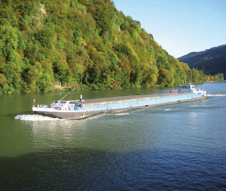
Danube navigation at a glance                                                                               17

Strengths and weaknesses of Danube navigation
The principal strengths of Danube navigation are the ability to transport large
quantities of goods per vessel unit, its low transport costs and its environmental
friendliness. Furthermore, it is available around the clock, with no prohibition on
driving at weekends or during the night and can provide a high degree of safety and
low infrastructure costs.

The weaknesses lie in its dependence on fluctuating fairway conditions and the
consequent, varying degree of the vessel load factor, the low transport speed and
network density, which often necessitate pre- and end-haulage by road or rail.

The opportunities of Danube navigation are the high free capacities of the waterway,
international development initiatives such as the Strategy for the Danube Region,
the internalisation of external costs at European level, cooperation with road and
rail, as well as the use of modern and harmonised River Information Services (RIS).

The threats to Danube navigation are found in the different political and hence bud-
getary importance assigned to this transport mode in the individual Danube states,
as well as in the need to modernise many Danube ports and parts of the Danube
fleet.

   STRENGTHS                                   WEAKNESSES

  •   Low transport costs                     • Dependence on variable fairway
  •   Bulk freight capacity                     conditions
  •   Environmental friendliness              • Low transport speed
  •   Safety                                  • Low network density,
                                                often requiring pre-/end-haulage
  •   Availability around the clock
  •   Low infrastructure costs

   OPPORTUNITIES                               THREATS
   • Free capacities of the waterway          • Inadequate maintenance of the waterway
   • Rising demand for green                    in some Danube riparian countries
     transport modes                          • Administrative barriers lead to
   • Modern and internationally                 competitive disadvantages
     harmonised information services (RIS)
                                                                                         Source: viadonau

                                                (e.g. time-consuming/expensive checks)
   • Cooperation with road and rail           • High requirement to modernise
   • International development initiatives      the ports and fleets
     (e.g. Strategy for the Danube Region)

SWOT analysis of Danube navigation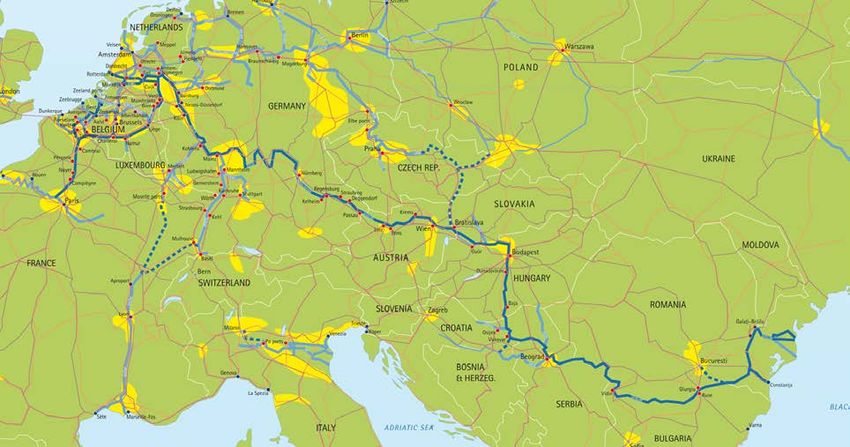
20                                                                                                         Danube navigation at a glance

                                               Infrastructure costs

                                               Infrastructure costs are comprised of the costs for building and maintaining trans-
                                               port routes. As in most cases it is possible to make use of the inland waterways as
                                               natural infrastructure, the infrastructure costs are low for inland navigation. Detailed
                                               comparisons with land transport modes in Germany are available: They indicate that
                                               the infrastructure costs per tonne-kilometre for road and rail are four times higher
                                               than for waterways ( PLANCO Consulting & Bundesanstalt für Gewässerkunde,
                                               2007).

                                               Current cost estimates of infrastructure projects in the riparian states suggest that
                                               improving the complete infrastructure of the 2,415 km Danube waterway would cost
                                               1.2 billion Euros in total. This is more or less equivalent to the costs of constructing
                                               around 50 km of road or rail infrastructure. Current European rail tunnel projects
                                               each cost 10 to 20 billion Euros.

                                               Relevance of Danube navigation
                                               Danube waterway transport in a European comparison

               Statistical data for the        In total, 558 million tons of goods were transported on the inland waterways of the
               EU-28 countries were            European Union in 2017. The transport performance was 147 billion ton-kilometres.
     taken from the online database of         Accordingly, the average distance of waterway freight transport was 263 km.
     Eurostat, the statistical office of the
     European Union:                           The Main-Danube Canal creates an important basis for the 3,500 km, central Rhine-
     ec.europa.eu/eurostat;                    Main-Danube inland waterway, which extends through all of European mainland
     this comprises of estimated and           from the Port of Rotterdam on the North Sea to the Seaport of Constanţa on the
     preliminary values. Values for            Black Sea. With a transport volume of 186 million tons, the Rhine has significantly
     the Danube region are based on            higher utilisation than the Danube, which was used to transport 39 million tons in
     enquiries by viadonau, which were         2017. Nonetheless, goods are transported for longer distances on the Danube, as
     conducted on the basis of national        shown by the transport performance for these two key European waterways: 25
     statistics.                               billion ton-kilometres on the Danube (mean transport distance approx. 600 km)
                                               compared to 40 billion ton-kilometres on the Rhine (mean transport distance approx.
                                               200 km).

                                               If one considers the transport volumes along the Danube waterway and its navigab-
                                               le tributaries in the individual Danube riparian states, by far the largest transport
                                               volume for 2017 was recorded by Romania with 19.1 million tons, followed by Serbia
                                               with 12.5 million tons and Austria with 9.5 million tons.

                                               Maritime transport on the Danube, i.e. transport on river-sea or sea-going vessels
                                               on the Lower Danube (Romania and Ukraine), accounted for 5.8 million tons in 2017,
                                               whereby the majority was transported via the Sulina Canal.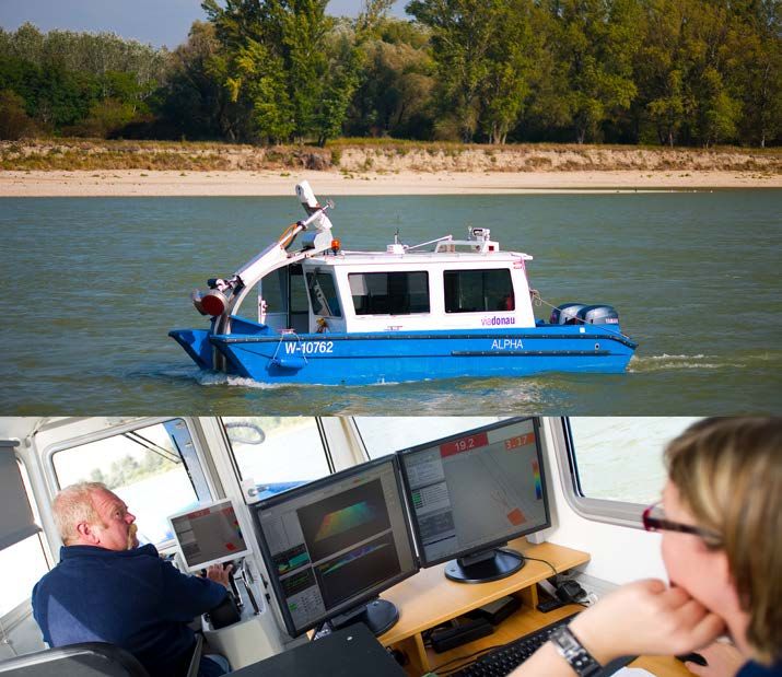
Danube navigation at a glance                                                                                                                                            21

                                                                                                                             Source: viadonau, Central Commission for the
                                                                                                                             Navigation of the Rhine
The European inland waterways Rhine and Danube in comparison

    Modal split

    In the 28 countries of the European Union, waterways made up a 6.0% share of                      Detailed statistics on the
    the modal split in 2017 – which means that 6.0% of all freight ton-kilometres were                topic of transportation in
    handled on waterways. This share differs sharply in the individual EU states. The        the European Union:
    Netherlands, for instance, have important seaports and a highly integrated inland        epp.eurostat.ec.europa.eu
    waterway network which is divided into small sections. This results in the highest
    inland navigation share of the 28 EU countries (44.7% in 2017).

    The infrastructural circumstances in the Danube region are different: Goods trans-
    port by waterway is concentrated on one main river. While it is able to transport very            Statistics on Danube
    large quantities of freight to some extent, the small number of branches also means               navigation from the
    that it can only be used in focused regional areas. The Danube is therefore confined     Danube Commission:
    to a limited form of transport requiring longer pre- and end-haulage by road and rail.   www.danubecommission.org
    This is why the waterways tend to account for a smaller share of the national modal
    split in the countries of the Danube region.

       Danube freight transport in Austria                                                            Annual reports on
                                                                                                      Danube navigation in
       In a longtime average, around 10 million tons of goods are transported on the         Austria are published
       Austrian Danube each year. Around a third of these goods are ores and scrap           by viadonau and are available to
       metals, while petroleum products, agricultural products and forestry products         download at www.viadonau.org
       each account for around one eighth of the transported goods.

       The waterway share in the modal split in the Austrian Danube corridor is
       roughly 10%. The Danube plays an important role mainly in upstream trans-
       port, especially in imports via the eastern border. In this area, the Danube is
       approximately neck and neck with rail transports.
Objectives and strategies                                                                                                                   29

Belgrade Convention                                                                                 The signatory states of
                                                                                                    the Belgrade Convention
The Convention Regarding the Regime of Navigation on the Danube was signed by            are Bulgaria, Germany, Croatia,
all Danube riparian states (‘Belgrade Convention’ of 1948). Its main objectives are to   Moldova, Austria, Romania, Russia,
safeguard the freedom of navigation on the Danube for all states as well as to oblige    Serbia, Slovakia, Ukraine and
the Danube states to maintain their sections of the Danube waterway to a navigable       Hungary.
condition.

                                                                                                                         Source: INTERACT
Area of application of the Danube Strategy

The implementation of the Belgrade Convention, together with adherence to its                       Further information about
provisions, is supervised by the Danube Commission which is based in Budapest.                      the Danube Commission,
The Commission is made up of the signatory states of the Belgrade Convention.            including the text of the Belgrade
                                                                                         Convention:
Danube River Protection Convention                                                       www.danubecommission.org

The International Commission for the Protection of the Danube River (ICPDR) was                     Further information about
founded in 1998 and is located in Vienna. The dedicated aim of the ‚Danube River                    the Danube River Protec-
Protection Commission’ is the implementation of the Convention on Cooperation for        tion Commission and the Danube
the Protection and Sustainable Use of the Danube River (‘Danube River Protection         River Protection Convention:
Convention’) as well as that of the Water Framework Directive (WFD) of the European      www.icpdr.org
Union in the Danube region. The signatories of this convention – along with members
of the commission – are 14 Danube states and the European Union.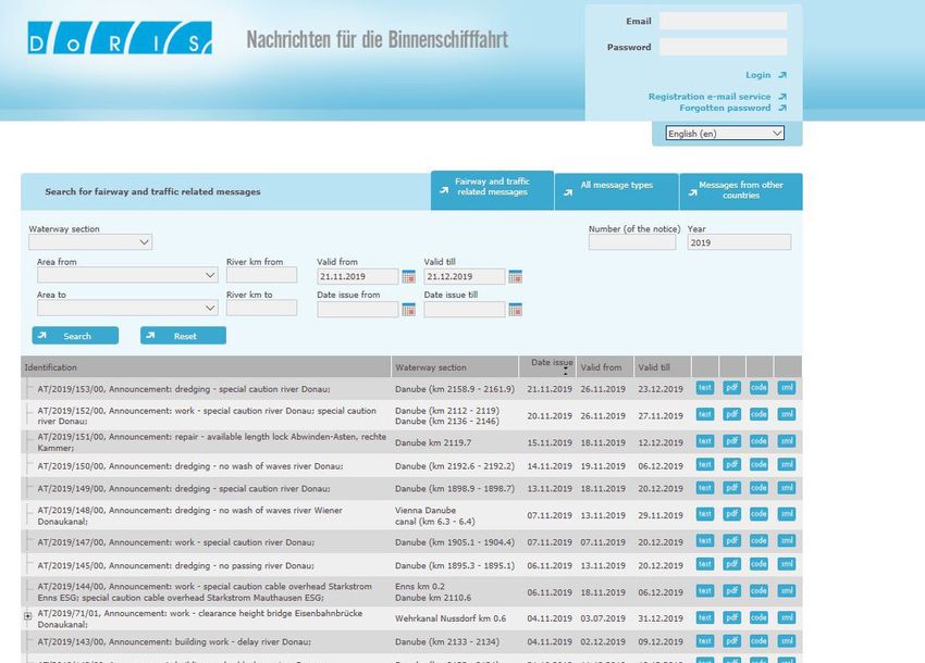
38                                                                   System elements of Danube navigation: Waterway

     The Danube and its tributaries
     Geopolitical dimensions

     On its way from the Black Forest, in Germany, to its mouth in the Black Sea in Roma-
     nia and the Ukraine, the Danube passes through ten riparian states, which makes it
     the most international river in the world.

                         River-km 2,414.72                                                 River-km 2,414.72

                                              Germany                      Germany
                         River-km 2,223.15
                                                                                           River-km 2,201.77

                                              Austria                      Austria

                                                                                           River-km 1,880.26
                         River-km 1,872.70

                                              Slovakia                     Slovakia
                         River-km 1,811.00
                                                                                           River-km 1,708.20

                                              Hungary                      Hungary
     Right Danube bank

                                                                                                               Left Danube bank
                         River-km 1,433.00                                                 River-km 1,433.00

                                              Croatia
                         River-km 1,295.50
                                                                           Serbia

                                                                                           River-km 1,075.00
                                              Serbia

                         River-km 845.65

                                                                           Romania
                                              Bulgaria

                         River-km 374.10
                                                                                                               Source: viadonau

                                              Romania
                                                                           Moldova           River-km 134.14
                                                                                             River-km 133.59
                                                                           Ukraine
                         River-km 0                                                              River-km 0
                         Danube riparian states and common border stretches on the navigable Danube waterway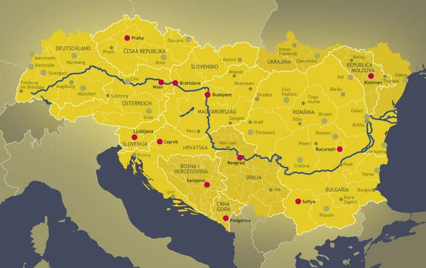
System elements of Danube navigation: Waterway                                                                                   39

With a total length of 1,075 kilometres, Romania has the largest share of the Da-
nube, representing almost a third of the entire length of the river. Thereof, some 470
kilometres make up the common state border with Bulgaria. Moldova has the smal-
lest share of the Danube with only 550 metres. Four countries, i.e. Croatia, Bulgaria,
Moldova and Ukraine, are situated on only one bank of the river.

The Danube marks a state border along 1,025 km of its length, which corresponds to
36% of its entire length (calculated from the confluence of the Breg and Brigach head-
streams in Germany to Sulina at the end of the Danube’s middle delta distributary in
Romania) or to 42% of its navigable length (Danube waterway from Kelheim to Sulina).

                                                                                                 Source: viadonau/Pilo Pichler

River basin district and discharge

The river basin district is the catchment area where all water from land surfaces,
streams and ground water sources drains into the respective river. The river basin of
the Danube covers 801,463 km². It lies to the west of the Black Sea in Central and
South-Eastern Europe.

The diagram on the following page shows the structure of the average discharge for the
entire length of the Danube, depicting the water distribution of the Danube’s main tribu-
taries and their geographical position (right bank, left bank). The term ‘discharge’ refers to
the amount of water which passes by at a certain spot of the watercourse over a specific
unit of time. Generally, discharge is indicated in cubic metres per second (m³/sec). At its
mouth, the Danube has an average discharge of about 6,550 m³/sec, which makes the
Danube the river with the highest runoff in Europe.

In terms of average inflow, the five major tributaries of the Danube are the Sava
(1,564 m³/sec), Tisa/Tisza/Tysa (794 m³/sec), Inn (735 m³/sec), Drava/Drau
(577m³/sec) and Siret (240 m³/sec).

The longest tributary of the Danube is the Tisa/Tisza/Tysa with a length of 966
kilometres, followed by the Prut (950 kilometres), Drava/Drau (893 kilometres), Sava
(861 kilometres) and Olt (615 kilometres).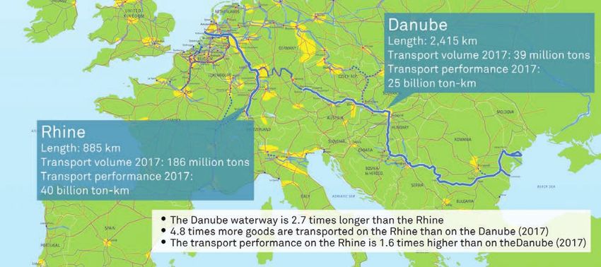
40                                                                        System elements of Danube navigation: Waterway

             River kilometre                                      Breg         Brigach
     2,845

                         non-navigable section                    Iller
                            of the Danube                       Lech
                                                                               Altmühl
                                                                               Naab                                   Kelheim
     2,414
                                                                              Regen
                                                               Isar
                                                        Inn
                                                Traun
                                                Enns
                                               Ybbs
                                                                                 Kamp
     2,000                                                      Vienna           March
                                                          1,917 m3/sec
                                     Leitha, Rába                                    Váh
                                                                                    Hron
                                                                                   Ipel’ / Ipoly
                                                              Budapest
                                                          2,352 m3/sec
                                               Sió
     1,500
                                      Drava

                                                                                              Tisa
                     Sava                                                                       Tamiš
               Morava
                                                                                                   Nera
                                                          Drencova
     1,000                                               5,480 m3/sec
                Timok

                 Iskar                                                                             Jiu
                                                              Corabia
                                                                                                    Olt
                                                         5,780 m3/sec

                                                                                                                                Source: viadonau based on Komoli, 1992
                                                                                                     Vede a
               Jantra
      500                                                                                            Argeş

                                                                                                     Ialomiţa
                                                                                                         Siret
                                                               Brăila
                                                                                                           Prut
                                                              6,147 m3/sec

       0
                                                              right bank     left bank
                                                                                                           average discharge
                         0      1,000       2,000 m3/sec            66%      34%

                    Average discharge of the Danube from its source to its mouth, based on data for the years 1941–2001
System elements of Danube navigation: Waterway 41
Length and gradient
With a length of 2,845 kilometres, the Danube is Europe’s second-longest river
after the Volga. In one of its first hydrographic publications, the European Danube
Commission, which was established in 1856, stated that the Danube originates at
the confluence of its two large headstreams, the Breg and the Brigach, at Donau-
eschingen in the Black Forest in Germany and that from this confluence the river has
a length of 2,845 kilometres (measured to its mouth in the Black Sea at river-km 0 in
Sulina at the middle distributary of the Danube delta). When measuring the distance
from the origin of the longer of the two headstreams, the Breg, at Furtwangen to the
Black Sea at Sulina, the overall length amounts to 2,888 kilometres.
Due to the high gradient in the first third of its course (over a length of 1,055 kilome-
tres), the upper part of the Danube has the characteristics of a mountain river. For
this reason, nearly all river power plants, taking advantage of the gradient of a water-
course, are located on this part of the Danube. Only after the change of gradient at
Gönyű in the north of Hungary (river-km 1,791) does the river gradually change into a
lowland river.
While the Upper Danube has an average height difference of slightly more than 0.5
metres per kilometre, the average height difference on the Lower Danube is only
slightly more than 4 centimetres per kilometre. The following illustration shows the
gradient curve of the Danube from its source at Donaueschingen to its mouth in the
Black Sea.
Height in m
700
Donaueschingen (DE)
600
Upper Danube Central Danube Lower Danube
500
565 m on 1,054 km 68 m on 860 km 39 m on 931 km
400
Kelheim (DE)
2,411 Regensburg (DE)
300 2,370
Source: viadonau
200
Vienna (AT)
1,929
Gönyű (HU)
100 1,791 Belgrade (RS)
1,170 Iron Gate (RS/RO)
931 Sulina (RO)
0
2,845 2,600 2,400 2,200 2,000 1,800 1,600 1,400 1,200 1,000 800 600 400 200 0
Distance to the Black Sea in km
Gradient curve of the Upper, Central and Lower Danube42 System elements of Danube navigation: Waterway
Classification of inland waterways
Working Party on Inland Wa- A waterway is a body of surface water serving as a route of transport for goods and/
ter Transport of the UNECE’s or passengers by means of vessels. Navigable inland transport routes are called in-
Inland Transport Committee: land waterways. Natural inland waterways are provided by rivers and lakes, whereas
www.unece.org/trans/main/sc3/ canals are artificial waterways.
sc3.html
In order to create the most uniform conditions possible for the development,
maintenance and commercial use of Europe’s inland waterways, in 1996 the In-
land Transport Committee of the United Nations Economic Commission for Europe
(UNECE) adopted the European Agreement on Main Inland Waterways of Internati-
onal Importance (AGN) ( United Nations Economic Commission for Europe, 2010).
The Agreement, which came into force in 1999, constitutes an international legal
framework for the planning of the development and maintenance of the European
inland waterway network and for ports of international importance, and is based on
technical and operational parameters.
By ratifying the Agreement, the contracting parties express their intention to imple-
ment the coordinated plan for the development and construction of the so-called
E waterway network. The E waterway network consists of European inland water-
ways and coastal routes which are of importance for international freight transport,
including the ports situated on these waterways.
E waterways are designated by the letter ‘E’ followed by a number or a combination
of numbers, whereby main inland waterways are identified by two-digit numbers and
branches by four- or six-digit numbers (for branches of branches). The international
waterway of the Danube is designated as E 80, and its navigable tributary the Sava,
for example, as E 80-12.
Waterway classes are identified by Roman numbers from I to VII. Waterways of class
IV or higher are of economic importance to international freight transport. Classes I
to III identify waterways of regional or national importance.
The class of an inland waterway is determined by the maximum dimensions of the
vessels which are able to operate on this waterway. Decisive factors in this respect
are the width and length of inland vessels and convoys, as they constitute fixed re-
ference parameters. Restrictions regarding the minimum draught loaded of vessels,
which is set at 2.50 metres for an international waterway, as well as the minimum
height under bridges (5.25 metres in relation to the highest navigable water level)
can be made only as an exception for existing waterways.
The following table shows the parameters of international waterway classes based on
type of vessels and convoys which can navigate the waterway of the respective class.System elements of Danube navigation: Waterway 43
Motor cargo vessels
Type of vessel: general characteristics
Water-
Max. length Max. width Draught Min. height under
way Designation Deadweight T (t)
L (m) B (m) d (m) bridges H (m)
class
IV Johann Welker 80-85 9.5 2.5 1,000-1,500 5.25 / 7.00
Va Large Rhine vessel 95-110 11.4 2.5-2.8 1,500-3,000 5.25 / 7.00 / 9.10
Vb Large Rhine vessel 95-110 11.4 2.5-2.8 1,500-3,000 5.25 / 7.00 / 9.10
VIa Large Rhine vessel 95-110 11.4 2.5-2.8 1,500-3,000 7.00 / 9.10
VIb Large Rhine vessel 140 15.0 3.9 1,500-3,000 7.00 / 9.10
VIc Large Rhine vessel 140 15.0 3.9 1,500-3,000 9.10
VII Large Rhine vessel 140 15.0 3.9 1,500-3,000 9.10
Source: United Nations Economic Commission for Europe, 2010
Pushed convoys
Type of convoy: general characteristics
Water-
Width Draught Min. height under
way Formation Length L (m) Deadweight T (t)
B (m) d (m) bridges H (m)
class
IV 85 9.5 2.5-2.8 1,250-1,450 5.25 / 7.00
Va 95-110 11.4 2.5-4.5 1,600-3,000 5.25 / 7.00 / 9.10
Vb 172-185 11.4 2.5-4.5 3,200-6,000 5.25 / 7.00 / 9.10
VIa 95-110 22.8 2.5-4.5 3,200-6,000 7.00 / 9.10
VIb 185-195 22.8 2.5-4.5 6,400-12,000 7.00 / 9.10
VIc 270-280 22.8 2.5-4.5 9,600-18,000 9.10
195-200 33.0–34.2 2.5-4.5 9,600-18,000 9.10
VII 275-285 33.0–34.2 2.5-4.5 14,500-27,000 9.10
Waterway classes according to the AGN
In 1998, the UNECE Inland Transport Committee first published an Inventory of Main
Standards and Parameters of the E Waterway Network, the so-called ‘Blue Book’, ‘Blue Book’ database:
as a supplement to the AGN ( United Nations Economic Commission for Europe, www.unece.org/trans/main/sc3/
2012). The ‘Blue Book’ contains a list of the current and planned standards and para- bluebook_database.html
meters of the E waterway network (including ports and locks) as well as an overview
of the existing infrastructural bottlenecks and missing links. This publication, which
supplements the AGN, allows for the monitoring of the current state of implementa-
tion of the agreement on an international basis.44 System elements of Danube navigation: Waterway
The international Danube waterway
The most important inland waterway axis on the European mainland is the Rhine-
Main-Danube Corridor. The Rhine and Danube river basins, which are connected
by the Main-Danube Canal, are the backbone of this axis. The Main-Danube Canal
was opened to navigation in 1992 and created an international waterway between
the North Sea in the West and the Black Sea in the East. This waterway has a total
length of 3,504 kilometres and provides a direct waterway connection between 15
European countries.
North
Sea
Rhine
Main-Danube Canal
Main
Source: viadonau, Inland Navigation Europe
Danube
Black
Sea
The inland waterway axis Rhine-Main-Danube
The navigable length of the Danube available to international waterway freight
Danube Commission: transport is just under 2,415 kilometres, starting from Sulina at the end of the
www.danubecommission.org middle Danube distributary into the Black Sea in Romania (river-km 0) to the end
of the Danube as a German federal waterway at Kelheim (river-km 2,414.72). The
Kelheim–Sulina main route is subject to the Convention Regarding the Regime of
Navigation on the Danube of 18 August 1948 (‘Belgrade Convention’), which ensures
free navigation on the Danube for all commercial vessels sailing under the flags of all
nations.
For more information According to the definition of the Danube Commission, the international Danube
concerning the Danube waterway can be subdivided into three main sections for which the nautical charac-
Commission and the Belgrade teristics are provided in the following table. This division into three main sections is
Convention, refer to the chapter based on the physical-geographical characteristics of the Danube river.
‘Objectives and Strategies’.System elements of Danube navigation: Waterway 45
Upper Danube Central Danube Lower Danube
Source: viadonau, Danube Commission
Kelheim – Gönyű Gönyű – Turnu-Severin Turnu-Severin – Sulina
Length of section 624 km 860 km 931 km
River-km 2,414.72–1,791.33 1,791.33–931.00 931.00–0.00
Ø gradient per km ~ 37 cm ~ 8 cm ~ 4 cm
Height of fall ~ 232 m ~ 68 m ~ 39 m
Upstream travel speed
9–13 km/h 9–13 km/h 11–15 km/h
of vessels
Downstream travel
16–18 km/h 18–20 km/h 18–20 km/h
speed of vessels
Nautical characteristics of the different Danube sections
The waterway classes of the various sections of the Danube and the largest pos-
sible vessel units (convoys) which are able to operate on these sections are shown
in the following diagram. This diagram also includes the differences in the possible
combinations of vessels in convoys for upstream and downstream travel as well as
the impounded and free-flowing sections of the Danube waterway.
Mai
n 38
4 km MD
171-Canal
km
Upp
km
er D
anu
be 6
69
24 k impounded
m
km
en
km
32
free-flowing
of
52
sh
Cen
ey
tral
il
-V
Dan
all
ube
va
m
ing
v
860
l
0k
a
ne
au
km
ub
isl
an
64
ch
ra
at
ch
Wa
St
Br
a-
ge
Low
er D
nn
ar
rg
anu
ch
Vie
be 9
be
31 k
dis
m
m
m
Ba
4k
vo
I
ίko
86
+I
rg
ge im
bu
bč
I
Re lhe
ate
ns
Ga
u
76 Ke
sa
ail
a
nG
i
va
nn
as
ţ
2,3 411
ala
Izm
Iro
sla
p
3P
Vie
Sa
st
0G
2,
ati
90
nt
23
pe
20
10
15
pla
2,
Br
da
1,9
ina
1,8
85
Bu
r
we
Bla stan Sul
1,8
la
40
Po
răi
1,6
ţa
0B
a
Se
cs
17
n
há
ck
Co
UNECE Waterway
Waterway classes
classes
Mo
*
48
1,4
VII
e
ad
Source: viadonau
VIc
lgr
Be
Se eta-
VIb
rin
68
ve
rnu b
VIa
1,1
Tu 1 Dro
* The Lower Danube is navigable for
Vb
93
pushed convoys that are composed of
Va more than nine pushed lighters
Maximum possible dimensions of convoys on the Danube waterway according to waterway classes46 System elements of Danube navigation: Waterway
From Regensburg to Budapest (except for the Straubing–Vilshofen section in Bava-
ria) the Danube is classified as waterway class VIb and is navigable by 4-unit pushed
convoys. The 69-km nautical bottleneck between Straubing and Vilshofen on the
Bavarian section of the Danube is classified as waterway class VIa and is navigable
by 2-lane 2-unit convoys.
Between Budapest and Belgrade the Danube is basically navigable by 2-lane and
3-lane 6-unit convoys. Here, the Danube is classified as waterway class VIc.
On the section downstream from Belgrade to the Danube delta (Belgrade–Tulcea)
the Danube is classified as waterway class VII (highest class according to the UNECE
classification). This entire section is navigable by 9-unit convoys while some subsec-
tions are suitable for even larger convoys.
Apart from the Kelheim–Sulina main route, several navigable distributaries and side
arms, canals and tributaries form an integral part of the Danube waterway system.
Apart from the Kelheim–Sulina section, all other transport routes are national
waterways which are each subject to different regulations. The table on the following
page provides an overview of these waterways.
The length of navigable waterways in the Danube basin (Danube including all navi-
gable distributaries and side arms, canals and tributaries) comes to approximately
6,300 kilometres. 58% or 3,600 kilometres of these are waterways of international
importance, i.e. waterways of UNECE class IV or higher.
GERMANY
212.95 river-km Donau POLAND UKRAINE
Prague 53.95 river-km Dunaj
CZECH REPUBLIC MOLDOVA
SLOVAKIA 0.55 river-km
Main-Danube Canal 172.06 river-km Dunaj Dunaj
Danube
HUNGARY Chişinău
Vienna 378.00 river-km Duna
Danube Tisza Prut
AUSTRIA Danube delta
350.45 river-km Donau
Danube ROMANIA Sulina
1,075.00 river-km Dunărea
SWITZERLAND
SLOVENIA CROATIA
137.50 river-km Dunav
Drava
ITALY Constanţa
Source: viadonau
Danube
BOSNIA AND
Capital (with port) HERZEGOVINA Black Sea
Adriatic Sea
SERBIA
Significant port 587.35 river-km Dunav BULGARIA
Lock 471.55 river-km Dunav
Overview of the waterways in the Danube regionSystem elements of Danube navigation: Waterway 47
UNECE
Name of waterway Riparian countries Navigable length Number of locks
Waterway class
Distributaries of the Danube:
Kilia arm / Bystroe arm Romania + Ukraine 116.60 km VII / VIa 0
Sulina arm Romania 62.97 km VII 0
Sfântul Gheorghe arm Romania 108.50 km VIb + Vb 0
Side arms of the Danube:
Bala / Borcea Romania 116.60 km VII 0
Măcin Romania 98.00 km III 0
Szentendre Hungary 32.00 km III 0
Canals:
Danube-Black Sea Canal Romania 64.41 km VIc 2
Poarta Albă-Midia Năvodari
Romania 27.50 km Vb 2
Canal
Hidrosistem Dunav-Tisa-
Serbia 657.50 km I - III 15
Dunav
Main-Danube Canal Germany 170.78 km Vb 16
Tributatries of the Danube:
Prut Moldova + Romania 407.00 km II 0
Serbia + Croatia +
Sava 586.00 km III + IV 0
Bosnia and Herzegovina
Source: viadonau
Tisa/Tisza Serbia + Hungary 685.00 km I - IV 3
Drava/Dráva Croatia + Hungary 198.60 km I - IV 0
Váh Slovakia 78.85 km VIa 2
Important waterways in the Danube region
System elements of waterway infrastructure
The size of inland vessels or convoys suitable for specific inland waterways depends
mainly on the current infrastructure parameters of the waterway in question. The
following factors of waterway infrastructure influence navigation:
• Waterway and fairway (depth and width, curve radii)
• Lock chambers (available length and width of lock chambers, depth at pointing sill)
• Bridges and overhead lines (clearance and available passage width under
bridges and overhead lines)
In context with these determinants there are further framework conditions which
may influence navigation on a certain waterway section:
• Waterway police regulations (e.g. maximum permissible dimensions of
vessel units, limitations on the formation of convoys)
• Traffic regulations (e.g. one-way traffic only, maximum permissible speed on
canals or in danger areas)48 System elements of Danube navigation: Waterway
• Navigation restrictions and suspensions due to adverse weather conditions
(floods, ice formation), maintenance and construction works at locks, accidents,
events etc.
Water levels and gauges of reference
A water gauge measures the gauge height which corresponds to the height of water
at a certain point in the reference profile of a body of water, i.e. the water level. In
general, gauge heights are measured several times a day. Nowadays, they are also
published on the Internet by the national hydrographic services.
Source: viadonau/Andi Bruckner
11
10
W = 95 cm
9
8
Gauge staff at a gauging site; sample water level at gauge: 95 cm
It has to be kept in mind that the water level measured at a water gauge does not
allow for any conclusions about the actual water depth of a river to be made and
hence about current fairway depths. This is due to the fact that the gauge zero, i.e.
the lower end of a gauge staff or altitude of a gauge, does not correspond with the
location of the riverbed. The gauge zero can lie above or below the medium riverbed
level of a river section. In rivers, the flow of the current and the riverbed change fairly
often and hence the gauge zero of a water gauge cannot be constantly realigned.
When assessing the currently available water depths within the fairway, boat mas-
ters refer to gauges of reference, which are relevant for certain sections of inland
waterways. The water levels at the water gauge of reference are decisive for the
draught loaded of vessels, for the passage heights under bridges and overhead lines
as well as for restrictions on or suspension of navigation in periods of floods.
Reference water levels
The mean sea level measured at a gauging site of the nearest ocean coast serves as
the reference for determining the absolute or geographic level of a gauge zero on the
earth’s surface, the so-called absolute zero point. Hence, the water gauges along the
river Danube have different reference points: the North Sea (Germany), the Adriatic
Sea (Austria, Croatia, Serbia), the Baltic Sea (Slovakia, Hungary) and the Black Sea
(Bulgaria, Rumania, Moldova, Ukraine).
As the water level at a gauge changes continually, reference water levels or characteris-
tic water levels have been defined in order to gain reference values, e.g. on the maintai-
ned depth of the fairway. Characteristic water levels are statistical reference values for
average water levels which have been registered at a certain gauge over a longer period
of time. The most important reference water levels for inland waterway transport are:System elements of Danube navigation: Waterway 49
• Low navigable water level (LNWL) Low navigable water level
(LNWL) = the water level
• Highest navigable water level (HNWL) reached or exceeded at a Danube
water gauge on an average of 94% of
If the highest navigable water level (HNWL) is reached or exceeded by over a certain days in a year (i.e. on 343 days) over
degree, the authority responsible for the waterway section concerned may impose a a reference period of several deca-
temporary suspension of navigation for reasons of traffic safety. des (excluding periods with ice).
Highest navigable water level
Fairway and fairway channel (HNWL) = the water level reached or
exceeded at a Danube water gauge
The term fairway refers to the part of an inland waterway that is navigable for on an average of 1% of days in a year
shipping at a particular water level and that is marked by fairway signs. The fairway (i.e. on 3.65 days) over a reference
channel is the area of a body of inland water for which the waterway administration period of several years (excluding
seeks adherence to certain fairway depths and fairway widths for navigation purpo- periods with ice).
ses. The fairway channel is therefore part of the fairway. A ‘minimal’ cross section is
assumed on rivers in determining the cross-section of the channel, so its depth and
width. It is derived from the ‘most shallow’ and ‘narrowest’ points of a certain river
section at low water. For the Danube, the fairway channel depth determined for a
‘minimal’ cross section refers to the low navigable water level (LNWL). The current
fairway channel depth can be calculated with the following formula:
Current water level at gauge of reference
+ Minimum fairway channel depth at LNWL
- LNWL value for gauge of reference
= Current minimum fairway channel depth
In order to provide navigation with sufficient fairways channel depths of natural water-
ways during periods of low water levels and enable cost-effective transport on a river
even during such adverse water levels, river engineering measures may be taken. This
usually involves the installation of groynes that keep the river’s water yield in the fair-
way channel during low water levels. Groynes are structures which are normally made
up of armour stones which are dumped into a certain area of the riverbed at a right
angle or with a certain inclination. River engineering structures which are constructed
parallel to a river’s flow are called training walls and have the purpose of influencing
the flow direction of a body of water and stabilising its cross section.
Source: viadonau
Declining groyne, i.e. adjusted to the river’s flow direction, for river regulation at low water levels50 System elements of Danube navigation: Waterway
The authorities and organisations responsible for maintaining a waterway aim to
keep fairways at a constant minimum depth, e.g. by conservational dredging measu-
res in the fairway. These so-called minimum fairway channel depths are geared to
low navigable water level (LNWL) as a statistical reference value for the water level.
As there are no guaranteed minimum fairway channel depths at LNWL on the
For more information on Danube (with the exception of the Bavarian section of the Danube in Germany), boat
the interdependency of masters and shipping operators have to plan their journeys according to the fairway
available fairway channel depths channel depths which are currently available at the most shallow stretches of the
and the cost-effectiveness of Da- waterway or according to the admissible maximum draught loaded (= draught of a
nube navigation, refer to the section vessel when stationary) as foreseen by waterway police regulations.
‘Business management and legal
aspects’ in the chapter ‘Logistics The Romanian section of the Danube between Brăila and Sulina is also termed the
solutions: The market for Danube maritime Danube as this section is also navigable by river-sea vessels and sea-going
navigation’. vessels. 170 kilometres long, this river section is maintained by the Romanian River
Administration of the Lower Danube for vessels with a maximum draught of 7.32
metres. Beyond this, the Kilia/Bystroe arm, which is not subject to the Belgrade Con-
vention and which falls under the Ukrainian waterway administration, is navigable by
river-sea vessels and sea-going vessels.
Draught loaded, squat and underkeel clearance
Fairway depths available in the fairway channel determine how many tons of goods
may be carried on an inland cargo vessel. The more cargo loaded on board of a vessel,
the higher is its draught loaded, i.e. the draught of a ship when stationary and when
carrying a certain load. The draughts loaded usable for navigation companies have a
decisive influence on the cost-effectiveness of inland waterway transport.
Immersion depth = In calculating the potential draught loaded of a vessel on the basis of current fair-
draught loaded (vvessel = 0) + way or fairway channel depths, the dynamic squat as well as an appropriate safety
squat (vvessel > 0) clearance to the riverbed, the so-called underkeel clearance, have to be considered in
order to prevent groundings of cargo vessels in motion. The immersion depth of a ship
equals the sum of its draught loaded (loaded vessel in stasis; velocity v = 0) and its
squat (loaded vessel in motion; velocity v > 0).
Fairway channel
Towpath Staff gauge
Cross section of
an inland vessel Water level
Draught
Dive loaded
depth
Squat
Fairway
LNWL value
Source: viadonau
Underkeel channel
clearance depth
Gauge zero
Riverbed
Parameters of fairway channel (schematic presentation)System elements of Danube navigation: Waterway 51
Squat refers to the level to which a ship sinks while it is in motion compared to its
stationary condition on waterways with a limited cross section (i.e. rivers and canals).
A loaded vessel has a squat within a range of about 20 to 40 centimetres. As the
squat of a vessel is continually changing according to the different cross sections of
a river and the different velocities of a vessel, the boatmaster should not calculate
the safety clearance between the riverbed and the bottom of the vessel too tightly
when determining the draught loaded of his vessel.
This safety clearance is termed underkeel clearance and is defined as the distance
between the bottom of a vessel in motion and the highest point of the riverbed. Underkeel clearance =
Underkeel clearance should not be less than 20 centimetres for a riverbed made fairway channel depth –
of gravel or 30 centimetres for a rocky bed in order to prevent damage to the ship’s (draught loaded + squat)
propeller and/or its bottom.
Fairway signs
The width and the course of the fairway are marked by internationally standardised
fairway signs such as buoys or traffic signs ashore. Resolutions of the Working
Group on Inland Water
In 1985, the Inland Transport Committee of the United Nations Economic Commis- Transport of the UNECE’s Inland
sion for Europe (UNECE) adopted the European Code for Inland Waterways (CEVNI) Transport Committee:
in Resolution No 24 ( United Nations Economic Commission for Europe, 2015). www.unece.org/trans/main/sc3/
Among other things, CEVNI specifies standardisation of the fairway signs at Euro- sc3res.html
pean level and is fleshed out by the Guidelines for Waterway Signs and Marking ( ECE/TRANS/SC.3/115/Rev.5
United Nations Economic Commission for Europe, 2016a).
In regard to the marking of fairway limits in the waterway, the right side of the fairway
is indicated by red, cylindrical fairway signs, while the left side is delimited by green,
cone-shaped signs. The terms ‘right side’ and ‘left side’ of the waterway or fairway or
the fairway channel, apply to an observer looking downstream, i.e. in the direction in
which the water is flowing. Buoys (with or without red or green lights), floats or floa-
ting rods can be used as floating fairway signs. They must be fitted with a cylindrical
or conical top mark if their own shape is not cylindrical or conical.
Floating fairway signs must be equipped with radar reflectors to ensure that they
show up on the ship radar. They may be the aforementioned top marks or separate
signs that are attached on or in the fairway signs.
Together with the floating signs on the waterway, fixed fairway signs on land indicate
the course of the fairway relative to the banks and show the points at which the fair-
way comes closer to either of the banks. Square boards, either with or without a red
or green light, are used as land-side fairway signs.
Red and green rhythmic lights on the fairway signs help to improve transport safety
during poor visibility and at night. Rhythmic lights emit light of constant intensity
and colour with a certain, recurring succession of light signals and interruptions.
The Danube Commission adopted the UNECE provisions for the Danube waterway in
its Basic Rules of Navigation on the Danube (DFND) ( Danube Commission, 2010)
and in the accompanying Instruction for installation of fairway signs on the Danube
( Danube Commission, 2015).52 System elements of Danube navigation: Waterway
Source: viadonau/Thomas Hartl
Manipulation of a red buoy to indicate the right-hand limit of the fairway on the Austrian section of the Danube
Landing sites
Landing sites are specially marked areas on the banks of a waterway at which ves-
sels or floating bodies can berth. There may be many reasons why a ship would have
to interrupt its travel and berth at a landing site. Loading and unloading of cargo, em-
barking or disembarking of passengers, bunkering of fuel, adherence to rest periods,
crew changes, provisioning, visits to doctors or the authorities, repairs, health and
technical emergencies etc. However, landing sites are often reserved for certain ve-
hicles only (e.g. landings for small vessels, fuel landings, fire brigade landings) or are
used for a special function (transhipment sites, waiting berths, emergency berths).
A distinction can also be made between public and non-public landing sites.
Landing sites are marked by navigation signs that indicate the direction of the
landing site (relative to the navigation sign), its length, berthing rules and possibly
the maximum berthing period or vehicles that are exclusively permitted to use the
landing site, among other things.
The banks of a landing site are structurally designed either in slanted shoring
(riprap) or vertical shoring (wall or sheet piling). Vertical shoring enables direct
berthing close to the bank and increases safety when departing or boarding the
vessel. Established alternatives to vertical shoring include dolphins or pontoons that
are equipped with additional walkways that enable the crew to board or disembark
safely.
Some landings are equipped with additional facilities for navigation, including the
supply of shore-side power and drinking water, waste disposal, places to deposit a
car or lighting.System elements of Danube navigation: Waterway 53
Source: viadonau
Cargo vessel at a Danube landing site
River power plants and lock facilities
Barrages, i.e. facilities which impound a river with the aim of regulating its water
levels, are often created in the form of river power plants, which convert the power of
the flowing water into electrical energy. In this process they make use of the incline
created by impounding the water between the water upstream and downstream of
the power plant (headwater and tailwater).
A river power plant usually comprises of one or several powerhouses, the weir and
the lock with one or more lock chambers. Locks enable inland vessels to negotiate
the differences in height between the impounded river upstream of a power plant
and the flowing river downstream of a power plant.
The most common type of lock on European rivers and canals is the chamber lock
whereby the headwater and the tailwater are connected via a lock chamber which
can be sealed off at both ends. When the lock gates are closed, the water level in
the lock chamber is either raised to the headwater level (admission of water from
the reservoir) or lowered to the tailwater level (release of water into the section
downstream of the power plant). No pumps are required for the admission and
release of the water.
Depending on the direction in which a vessel passes through a lock, the terms used
are upstream locking (from tailwater to headwater) or downstream locking (from
headwater to tailwater). Once a vessel which needs to pass through a lock has been
announced via radio, the locking is carried out by the lock manager. A locking opera-
tion takes approximately 40 minutes, about half of which is required to navigate the
vessel into and out of a lock chamber.54 System elements of Danube navigation: Waterway
Source: viadonau
Lock facility at the river power plant at Vienna-Freudenau (river-km 1,921.05)
The fairway depth in a lock chamber is determined by the depth at the pointing sill –
the distance between the surface of the water and the pointing sill, i.e. the threshold
of a lock gate which forms a watertight seal with the gate to avoid drainage of the
lock chamber.
Special protective devices protect the lock gates from damage caused by vessels.
Stop logs serve to seal off lock chambers from headwater and tailwater in order to
drain lock chambers. They are used mainly for reasons of lock overhaul, i.e. for main-
tenance work or for the replacement of lock components.
There are a total of 18 river power plants on the Danube, with 16 of these power
plants located on the Upper Danube due to the high gradient of the river between
Kelheim and Gönyű. 14 of the 18 lock facilities on the Danube have two lock cham-
bers, thus enabling the simultaneous locking of vessels sailing upstream and
downstream.
The lock facilities downstream of Regensburg all feature a minimum utilisable
length of 226 metres and a width of 24 metres which enables locking of convoys
made up of at least two pushed lighters which are coupled in parallel.System elements of Danube navigation: Waterway 55
Lock chambers
No. Lock/power plant Country River-km Length (m) Width (m) Number
1 Bad Abbach DE 2,397.17 190.00 12.00 1
2 Regensburg DE 2,379.68 190.00 12.00 1
3 Geisling DE 2,354.29 230.00 24.00 1
4 Straubing DE 2,327.72 230.00 24.00 1
5 Kachlet DE 2,230.60 226.50 24.00 2
6 Jochenstein DE/AT 2,203.20 227.00 24.00 2
7 Aschach AT 2,162.80 230.00 24.00 2
8 Ottensheim-Wilhering AT 2,147.04 230.00 24.00 2
9 Abwinden-Asten AT 2,119.75 230.00 24.00 2
10 Wallsee-Mitterkirchen AT 2,095.74 230.00 24.00 2
11 Ybbs-Persenbeug AT 2,060.29 230.00 24.00 2
12 Melk AT 2,038.10 230.00 24.00 2
13 Altenwörth AT 1,980.53 230.00 24.00 2
14 Greifenstein AT 1,949.37 230.00 24.00 2
15 Freudenau AT 1,921.20 275.00 24.00 2
Source: viadonau
16 Gabčíkovo SK 1,819.42 275.00 34.00 2
17 Ðerdap/Porțile de Fier I RS/RO 942.90 310.00* 34.00 2
863.70
18 Ðerdap/Porțile de Fier II RS/RO 310.00 34.00 2
862.85
*The lock Ðerdap / Porțile de Fier I consists of two consecutive lock chambers which require two-stage lockage
Lock facilities along the Danube
Bridges
Bridges can span a waterway, a port entrance or a river power plant and hence a lock
facility. On free-flowing, i.e. unimpounded river sections, water levels can be subject
to considerable fluctuations which influence the potential passage under bridges at
high water levels.
Depending on the distances between the individual bridge pillars there will be one
or more – in most cases two – openings for passage of vessels. If a bridge has two
openings for passage which are dedicated for navigation purposes, one is generally
used for upstream traffic and the other for downstream traffic. Suitable navigation
signs that are mounted directly on the bridge indicate whether the passage through
a bridge opening is permitted or forbidden.
Whether a vessel can pass under a bridge depends on the vertical bridge clearance
above the water level and on the air draught of the vessel. The air draught of a
vessel is the vertical distance between the waterline and the highest fixed point of a
vessel once movable parts such as masts, radar devices or the steering house have56 System elements of Danube navigation: Waterway
been removed or lowered. The air draught of a vessel can be reduced by ballasting
the vessel. For this purpose, ballast water is pumped into the ballast tanks or solid
ballast is loaded.
Bridge clearance
Highest
fixed point
Air draught
Source: viadonau
Fairway width
Air draught of a vessel and vertical bridge clearance as determining parameters for passages under bridges
Apart from the height of the bridge openings and a vessel’s air draught, the bridge
profile is another factor which determines whether a vessel is able to pass under a
bridge. For sloped or arch-shaped bridges, not only a vertical but also a sufficiently
dimensioned horizontal safety clearance must be ensured. As the figures indicating
the height and width of an opening for passage below a bridge always refer to the
entire width of the fairway, the clearance below the crest of arch-shaped bridges, i.e.
below the centre of the bridge, is higher than at the limits of the fairway.
On free-flowing sections of rivers, vertical bridge clearance is indicated in relation
to the highest navigable water level (HNWL), whereby the indicated passage height
corresponds to the distance in metres between the lowest point of the lower edge of
the bridge over the entire fairway width and the highest navigable water level. The
width of the fairway below a bridge is indicated in relation to low navigable water le-
vel (LNWL). In river sections regulated by dams, the maximum impounded water level
serves as the reference value both for the vertical and the horizontal bridge clea-
rance. The reference level on artificial canals is the upper operational water level.
Between Kelheim and Sulina, a total of 129 bridges span the international Danube
waterway. Of these 129 Danube bridges, 21 are bridges over locks and weirs.
By far the greatest frequency of bridges is found on the Upper Danube (89 bridges):
41 bridges span the German section of the Danube, 41 the Austrian and seven the
Slovakian or Hungarian sections of the Danube. On the Central Danube there are a
total of 33 bridges; on the Lower Danube there are only seven.System elements of Danube navigation: Waterway 57 Fairway maintenance The necessary works for the maintenance of the fairway on natural waterways such as rivers depend on the general characteristics of the respective river: In free-flowing sections the flow velocity of the river is higher than in impounded sections, in artifi- cial canals or in sections flowing through lakes. The transport of sediments (e.g. gravel or sand) is an important dynamic process in free-flowing sections of rivers, especially in periods with higher water levels and the corresponding higher flow velocities of the river. Along with the respective discharge of the river, this transportation of sediment leads to continuous change in the morphology of the riverbed, either in the form of sedimentation or erosion. In shallow areas of the river this continuous change of the riverbed can lead to restrictions for navigation with regard to the minimum fairway parameters (depth and width) to be provided by waterway administrations, i.e. reduced depths and widths of the fairway. Legal and strategic framework The overriding aim with regard to the maintenance and optimisation of waterway infra- structure by the Danube riparian states is the establishment and year-round provision of internationally harmonised fairway parameters. The recommended minimum fairway parameters for European waterways of interna- tional importance – including the Danube – are listed in the European Agreement on Main Inland Waterways of International Importance (AGN) ( United Nations Econo- mic Commission for Europe, 2010). With regard to the fairway depths to be provided by waterway administrations, the AGN makes the following provisions: On waterways with fluctuating water levels the value of 2.5 metres minimum draught loaded of vessels should be reached or exceeded on 240 days on average per year. However, for upstream sections of natural rivers characterised by frequently fluctuating water levels due to weather conditions (e.g. on the Upper Danube), it is recommended to refer to a period of at least 300 days on average per year. Based on the Convention Regarding the Regime of Navigation on the Danube, which was signed in Belgrade on 18 August 1948 (‘Belgrade Convention’), the Danube Commis- sion recommended the following fairway parameters for the Danube waterway: 2.5 m minimum fairway depth (1988), respectively 2.5 m minimum draught loaded of ves- sels (2013) below low navigation water level (LNWL) (i.e. on 343 days on average per year) on free- flowing sections and a minimum fairway width of between 100 and 180 metres, dependent on the specific characteristics of the river section concerned ( Commission du Danube, 1988 or Danube Commission, 2011). On 7 June 2012, the transport ministers of the Danube riparian states met for the first time at the European Union’s Council of Transport Ministers in Luxemburg to agree on a Declaration on effective waterway infrastructure maintenance on the Danube and its navigable tributaries. The riparian states are committed to maintaining adequate fairway parameters for good navigational status according to the provisions of the ‘Belgrade Convention’ and – for those countries who have ratified it – the AGN.
58                                                                                          System elements of Danube navigation: Waterway

              Information about the        Clear guidelines to achieve the targets enshrined in the declaration were prepared in
              Master Plan and its          2014 by Priority Area 1a – Inland Waterways – within the EU Strategy for the Danube
     monitoring:                           Region in a central document, the Fairway Rehabilitation and Maintenance Master
     www.danube-navigation.eu/             Plan for the Danube and its Navigable Tributaries. The Master Plan indicates the
     documents-for-download                shallow sections along the Danube that are critical for navigation and describes the
                                           medium-term measures that are necessary in the area of waterway management in
              FAIRway Danube project:      order to alleviate these shallow sections. The Master Plan was jointly adopted by the
              www.fairwaydanube.eu         majority of the Danube transport ministers in 2014, providing significant political
                                           backing. The transport ministers confirmed once again in 2016 and 2018 that they would
              Further information on       provide the necessary funding at national level. Implementation of the Master Plan is
              the EU Strategy for the      reviewed twice each year.
     Danube Region and on the EU’s
     trans-European transport network      As a flanking measure, the transnational FAIRway Danube project, which is co-
     is found in the chapter ‘Objectives   funded by the EU, will carry out key aspects of the Master Plan by 2021 and in doing
     and Strategies’ of this manual.       so will make a significant contribution to its implementation.

                                                                                                                                             Source: Administraţia Fluvială a Dunării de Jos
                                           Bathymetric survey of the maritime Danube stretch in Romania near Tulcea

                                           Fairway maintenance cycle

                                           In the case that the minimum fairway parameters are not achieved, the responsible
                                           waterway administration is obliged to take suitable measures in order to re-estab-
                                           lish them. This is generally accomplished by dredging shallow areas (fords) within
                                           the fairway. Dredging is an excavation operation with the purpose of removing bot-
                                           tom sediments (sand and gravel) and disposing of them at a different location in the
                                           river in due consideration of ecological aspects.

                                           Where recurring dredging is necessary at certain fords, it is possible to implement
                                           hydraulic engineering optimisation measures in order to ensure adherence to the
                                           defined fairway parameters for navigation. Doing so significantly reduces ongoing
                                           dredging operations and improves availability of the fairway.
You can also read