Reality Capture of Buildings Using 3D Laser Scanners
←
→
Page content transcription
If your browser does not render page correctly, please read the page content below
Preprints (www.preprints.org) | NOT PEER-REVIEWED | Posted: 18 January 2021                              doi:10.20944/preprints202101.0331.v1

          Article

          Reality Capture of Buildings Using 3D Laser Scanners
          Avar Almukhtar1, *, Henry Abanda2, Zaid O. Saeed3 and Joseph H.M. Tah 4

                                       1 Dr. Avar Almukhtar, Lecturer at the School of the Built Environment, Oxford Brookes University; a.almu-
                                         khtar@brookes.ac.uk
                                       2 Dr. Henry Abanda, Reader at the School of the Built Environment, Oxford Brookes University ; fa-

                                         banda@brookes.ac.uk
                                       3 Zaid O. Saeed, Architect Engineer, MSc. Construction Project Management from School of the Built Envi-

                                         ronment, Oxford Brookes University ; Zaidosama94cpm@gmail.com
                                       4 Professor Joseph H.M. Tah, Pro Vice Chancellor and Dean, Faculty of Technology, Design and Environ-

                                         ment, Oxford Brookes University; jtah@brookes.ac.uk
                                       * Correspondence: a.almukhtar@brookes.ac.uk ; fabanda@brookes.ac.uk

                                       Abstract: The urgent need to improve performance in the construction industry has led to the
                                       adoption of many innovative technologies. 3D laser scanners are amongst the leading technologies
                                       being used to capture and process assets or construction project data for use in various applications.
                                       Due to its nascent nature, many questions are still unanswered about 3D laser scanning, which in
                                       turn contribute to the slow adaptation of the technology. Some of these include the role of 3D laser
                                       scanners in capturing and processing raw construction project data. How accurate is the 3D laser
                                       scanner or point cloud data? How does laser scanning fit with other wider emerging technologies
                                       such as Building Information Modelling (BIM)? This study adopts a proof-of-concept approach,
                                       which in addition to answering the afore-mentioned questions, illustrates the application of the
                                       technology in practice. The study finds that the quality of the data, commonly referred to as point
                                       cloud data is still a major issue as it depends on the distance between the target object and 3D laser
                                       scanner’s station. Additionally, the quality of the data is still very dependent on data file sizes and
                                       the computational power of the processing machine. Lastly, the connection between laser scanning
                                       and BIM approaches is still weak as what can be done with a point cloud data model in a BIM
                                       environment is still very limited. The aforementioned findings reinforce existing views on the use
                                       of 3D laser scanners in capturing and processing construction project data.

                                       Keywords: 3D Laser Scanners 1; Point-cloud Data 2; Reality Capture; BIM; Refurbishment

                                       1. Introduction
                                            The construction industry is in a state of constant change as it evolves from weak
                                       productivity driven by poor management and outdated methods, to adopting new
                                       building technologies (Larsen, et al., 2016; Omar et al. 2018). In the architecture,
                                       engineering, and construction (AEC) domain, 3D models are increasingly being used to
                                       improve project management. The 3D models contain vital data associated with building
                                       projects crucial for Building Information Modelling (BIM) processes, far better than
                                       traditional construction approaches. BIM workflows provide the opportunity to organise
                                       project data, such as building geometry, construction typology, and material properties
                                       that can be used in making informed decisions (Ham and Golparvar-Fard, 2015; Sanhudo,
                                       Ramos, Martins, Almeida, Barreira, Simões, and Cardoso, 2020). While BIM facilitates the

            © 2021 by the author(s). Distributed under a Creative Commons CC BY license.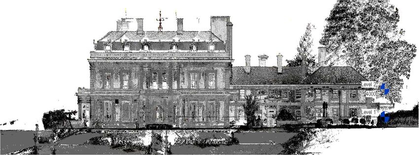
Preprints (www.preprints.org) | NOT PEER-REVIEWED | Posted: 18 January 2021                   doi:10.20944/preprints202101.0331.v1

                                    collaboration of supply chain members, the disparate backgrounds and the fact that they
                                    work on different aspects also present challenges related to data quality. Firstly, the
                                    various actors produce and capture different data at different stages of the project life
                                    cycle making it difficult to be able to obtain a complete model reflecting the project at any
                                    given time. Secondly, the different actors may decide to withhold models from others for
                                    various reasons such as professional secret or because they may not be involved in the
                                    later stages of the project. Thus, obtaining an accurate model that reflects the ‘as-is
                                    condition’ or ‘as-built’ in a project being deliver using BIM, talk less of traditional methods
                                    is hardly possible.
                                         In recent years, major technological advances allowed for detailed three-dimensional
                                    (3D) models to represent the ‘as-is condition’ of buildings (Lagüela et al., 2014; Sanhudo
                                    et al., 2018). Collecting the best and most accurate data about real-world conditions often
                                    known as ‘as-built’ or ‘as-is condition’ is what is known as reality capture. 3D laser
                                    scanning is a reality capture technique. There are many reasons for real capturing of
                                    project data which include: progress monitoring during construction project phase,
                                    facility operations for maintenance work (Shalabi and Turkan, 2017), sustainability, and
                                    waste management (Jalaei, Zoghi, Khoshand, 2019; Wang & Kim, 2019). The captured data
                                    using 3D laser scanners is often called ‘point cloud’.
                                         While BIM’s capability to support information creation, coordination, exchange, and
                                    application through the course of a building’s lifecycle has been firmly established in the
                                    literature (Chan et al, 2019), the need for capturing 3D models or ‘point cloud data’ for
                                    existing buildings and civil infrastructure is becoming increasingly important and crucial
                                    for the development of the industry (Pica and Abanda, 2019). That said, digitalizing
                                    substantial amounts of geometric information, which may be outdated or even non-
                                    existent, can be overwhelming. Thus, appropriate survey techniques are required for
                                    capturing, managing, and visualizing building information are needed (Sanhudo, Ramos,
                                    Martins, Almeida, Barreira, Simões, and Cardoso, 2020).
                                         Traditionally, as-built documentation using conventional surveying methods, such
                                    as a total station or a measuring tape, are labour-intensive, costly, and error-prone. In
                                    addition, only a portion of site elements can be monitored for practicality as traditional
                                    instruments can only provide spot measurements (Maalek, Lichti, and Ruwanpura, 2019).
                                    However, during the last decade, several new survey systems have been developed in the
                                    AEC industry to reflect different life cycles of a project (Remondino, 2011). While each of
                                    these techniques has its own advantages and limitations, it is important to understand the
                                    process from survey to 3D modelling, focusing on single precision data, overall accuracy,
                                    costs, acquisition, and processing times (Remondino et al., 2014; Guidi et al., 2014; Fassi,
                                    et al., 2013; Campi et al, 2017).
                                         This paper first discusses recent literature then goes on to explain the methodology
                                    used for both the development of a systematic review of 3D point cloud data, laser
                                    scanning, and the survey process in section 3. It then goes on to discuss the acquisition
                                    and processing of 3D point cloud data and BIM integration. The paper finally concludes
                                    with research findings and recommended future work in section 4.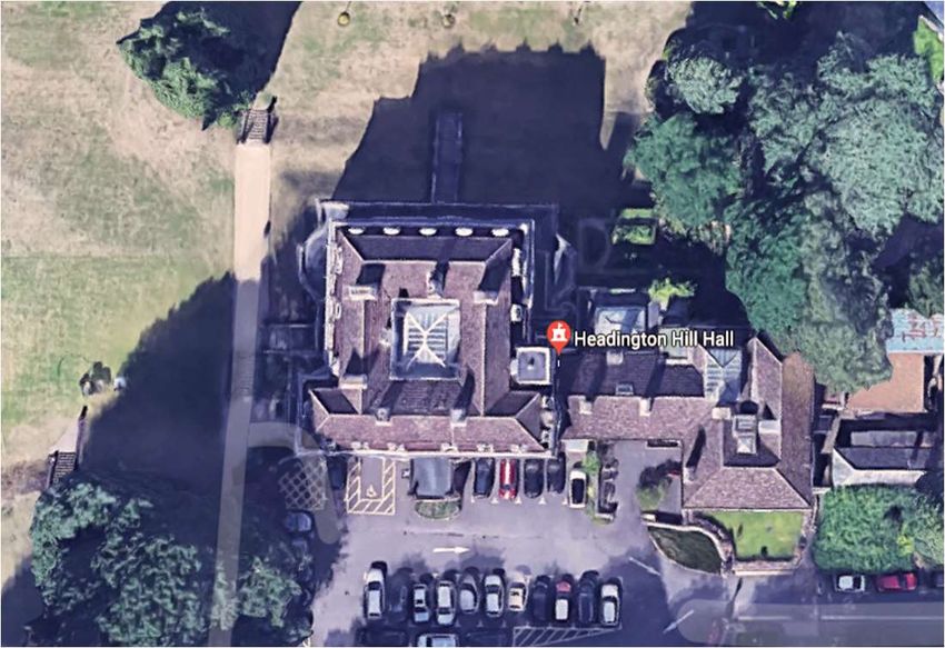
Preprints (www.preprints.org) | NOT PEER-REVIEWED | Posted: 18 January 2021                    doi:10.20944/preprints202101.0331.v1

                                    2. Related Studies
                                         As one of the most widely used 3D imaging techniques, laser scanning is utilized for
                                    a wide range of processes including surveying, manufacturing inspection, quality control
                                    of building construction, and restoration of heritage buildings. Laser scanning devices are
                                    now integrated within numerous built environment applications (Pärn and Edwards,
                                    2017), and are a consolidated technology for the collection, documentation, and analysis
                                    of three-dimensional data on the as-built status of buildings and infrastructure (Baladoa
                                    et al, 2018). Laser scanning, also known as high-definition surveying (HDS) or reality
                                    capture, is a means of using a laser to map an area with high accuracy. On a construction
                                    site, it is used to capture detailed data, providing accurate information for all stages of the
                                    project. The acquired data provides construction professionals with what is known as a
                                    ‘point cloud’, which is, a database connecting points in a 3D coordinate system. Point
                                    cloud systems keep an extremely accurate digital record of an object or space as it pertains
                                    to a project (Xiong, Adan, Akinci and Huber, 2013), and are composed of raw information
                                    that is processed to extract useful information for the applications they are intended to
                                    serve (Baladoa, et al, 2018). 3D point cloud data from 3D laser scanners are able to capture
                                    the surface geometries of target objects in an accurate and efficient manner, and provide
                                    accurate and fast records of the 3D geometries of construction-related objects (Wang &
                                    Kim, 2019).
                                         Laser scanning has been extensively applied in conjugation with BIM to cover several
                                    aspects of construction such as monitoring (Bosché, et al., 2015; Sanhudo, Ramos, Martins,
                                    Almeida, Barreira, Simões, and Cardoso, 2020), cost estimation and quality assessment
                                    (Kim, et al., 2016), 3D visualization and spatial analysis (Chao Chen et al., 2019) in an effort
                                    to increase accuracy, reduce errors, and rework. However, to present, very little literature
                                    provides a complete framework for the acquisition of point cloud data and how it is
                                    applied in BIM, with most studies focusing on the process after the data has been exported
                                    to BIM (Sanhudo, Ramos, Martins, Almeida, Barreira, Simões, and Cardoso, 2020). In
                                    addition, the literature has shown that the demand for 3D models in the AEC industry is
                                    constantly increasing (Cheng, Han, Li, Chen, Xing, Zhao, and Li, 2018), leading to the
                                    development of various technologies that are able to capture or measure existing
                                    buildings or structures within the built environment, and then present them in 3D for
                                    modelling purposes (Cheng, Han, Li, Chen, Xing, Zhao, and Li, 2018).
                                         Although laser scanners have been proven to provide high performance reality
                                    capture in an outdoor environment (Fryskowska et al., 2015; Cheng, Han, Li, Chen, Xing,
                                    Zhao, and Li, 2018), there is still a clear knowledge gap between the theory of laser
                                    scanning and its application for construction mapping due to technical limitations on
                                    portability and site constraints, and the cost of high-performance 3D laser scanners.
                                    Despite that increasing productivity in the construction industry could add up to $1.6
                                    trillion USD in value (McKinsey & Research), many construction professionals are still
                                    hesitant to adopt these technologies. This is mostly due to limited knowledge, and a lack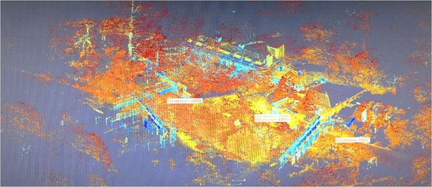
Preprints (www.preprints.org) | NOT PEER-REVIEWED | Posted: 18 January 2021                     doi:10.20944/preprints202101.0331.v1

                                    of a comprehensive framework that could assist built environment professionals during
                                    various lifecycles of a project.
                                         Notwithstanding the numerous advantages of laser scanning such as shorter survey
                                    duration that results in the acquisition of over a million points per second, and improved
                                    accuracy that captures complex shape geometries (Lagüela et al., 2014; Fröhlich and
                                    Mettenleiter, 2004; Sanhudo, Ramos, Martins, Almeida, Barreira, Simões, and Cardoso,
                                    2020), some limitations are still evident (Bhatla et al., 2012). These include the cost of
                                    equipment, the need for professional operators, integration with BIM systems, and the
                                    conversion of point cloud data into geometric forms that may be used to create the labelled
                                    BIM model elements (Göçer,         Hua, and Göçer, 2016; Sanhudo, Ramos, Martins, Almeida,
                                    Barreira, Simões, and Cardoso, 2020). This paper attempts to investigate the theoretical
                                    and practical challenges of using laser scanners. It provides a brief literature review on
                                    the use of 3D laser scanners. Followed by a systematic review followed by a field study
                                    for surveying, acquisition, and processing of 3D point cloud for both exterior and interior
                                    spaces. Both the results of the systematic review and the case study were used to propose
                                    a framework that reviews various 3D laser scanners for data acquisition and different
                                    software platforms for 3D point cloud data processing to explore its interoperability
                                    (integration) with BIM systems.
                                         Despite the multiple applications of laser scanning alongside BIM in the current
                                    research, most studies focused on the process after the point cloud data exportation, with
                                    little attention being given to the acquisition of the data itself.   In (Tang et al., 2010; Tang
                                    et al., 2011; Hichri et al., 2012), the authors divide the process of creating as-built BIM
                                    using laser scanning in three steps: data acquisition; data processing; and BIM integration.
                                    However, in most cases, the first two steps are simply briefly discussed, with the focus on
                                    BIM modelling; similarly, in (Wang et al., 2015), the authors present a methodology for
                                    the automatic extraction of BIM components from point cloud data, with the methodology
                                    starting after the point cloud data has been acquired (Sanhudo, Ramos, Martins, Almeida,
                                    Barreira, Simões, and Cardoso, 2020). Finally, in (Wang, et al. 2015) and (Lagüela et al.,
                                    2013), the authors respectively, propose methodologies that fuse laser scanning, infrared
                                    thermography and BIM for energy analysis. The focus of both articles fall on the processes
                                    after the acquisition of the point cloud, although Lagüela et al. (2013) identify the need for
                                    three scan station positions, referring to important aspects for the registration of the
                                    acquired scans (Sanhudo, Ramos, Martins, Almeida, Barreira, Simões, and Cardoso, 2020).
                                         Based on the systematic review, a significant number of research papers about point
                                    cloud from 3D laser scanners have been published in the past decade. However, most of
                                    the earlier publications have been about point cloud applications in the industrial and
                                    manufacturing sector. It has only been recently that point cloud applications have gained
                                    momentum in the construction industry. Therefore, the literature search was mainly
                                    focused on the last five years, corresponding to the period where much interest in the
                                    automation of construction processes has been focused. An attempt to summarize the
                                    evolution of research in 3D point cloud and 3D laser scanning through a systematic review
                                    from academic papers published from 2015 to 2020 is undertaken.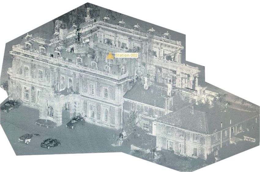
Preprints (www.preprints.org) | NOT PEER-REVIEWED | Posted: 18 January 2021                        doi:10.20944/preprints202101.0331.v1

                                      3. Materials and Methods
                                                 This paper has been developed based on a 3 step methodology: Systematic Review;
                                            Field Survey (Point Cloud Model development), and Framework proposal. A systematic
                                            review of literature is adopted in order to identify knowledge gaps which is further
                                            supported by a field survey. The survey was conducted using a 3D laser scanner which
                                            was followed by point cloud processing and BIM integration. The proposed framework
                                            was then developed from the knowledge and data acquired from both methods. The
                                            hardware and software with well-documented interoperability were chosen for the field
                                            survey. The Trimble TX8 laser scanner was used for the point cloud data acquisition, as it
                                            allows for simple surveying with a high degree of accuracy. Realworks and Autodesk
                                            Revit, were utilized to provide a greater understanding of the acquired point clouds and
                                            their relationship with BIM modelling. The details of the methods are discussed in the
                                            ensuing sections.

                                            3.1. Systematic Review
                                                 The systematic review aims to provide a thorough analysis of the applications of 3D
                                            point cloud data in the construction industry. Furthermore, it attempts to summarize the
                                            evolution of research in 3D point cloud and 3D laser scanning from academic papers
                                            published from 2015 to 2020. Following the review of different applications, discussions
                                            are provided regarding how to properly acquire and process point cloud data to fulfil the
                                            needs of construction applications.
                                                 The papers were obtained from selected peer-reviewed academic journals and
                                            databases. These include Science Direct, Emerald, Ebsco and Google Scholar. The search
                                            term used for literature search related to the acquisition and processing of point clouds
                                            were ‘3D Laser Scanning’ + ‘3D Pont Cloud’. The ‘3D Laser Scanning’ + ‘3D Pont Cloud’
                                            and ‘Scan to BIM’ search terms yielded results for Science Direct, Ebsco and Google
                                            Scholar and nothing for Emerald. A second attempt was undertaken whereby the term
                                            “abstract” was affixed to the terms ‘3D Laser Scanning’ + ‘3D Pont Cloud’ and ‘Scan to
                                            BIM’ to form ‘3D Laser Scanning’ + ‘3D Pont Cloud’ + ‘abstract’ and       ‘Scan to BIM’ +
                                            ‘abstract’ which yielded results from Emerald.    To facilitate understanding, the search
                                            results will be summarised in Tables 1, 2, 3 & 4 for Science Direct, Ebsco, Emerald, and
                                            Google Scholar respectively.

                                                          Table 1. Science Direct Results

                                        Using ‘3D laser scanning’ + ‘point clouds’ as a search term

              Journal                                                                              Year                    Papers
           1 ISPRS Journal of Photogrammetry and Remote Sensing                                  2019, 2017                   2
           2 Automation in Construction                                                             2019                      1
           3 Journal of Cultural Heritage                                                           2018                      1
           5 Measurement                                                                            2015                      1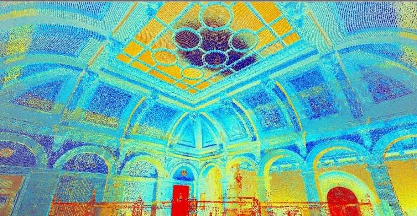
Preprints (www.preprints.org) | NOT PEER-REVIEWED | Posted: 18 January 2021                        doi:10.20944/preprints202101.0331.v1

           6 Pattern Recognition                                                                   2015                       1
                                                        Using ‘Scan to BIM’ as search term

           1 Journal of Building Engineering                                                       2020                       1
           2 Advanced Engineering Informatics                                                      2018                       1
                                                                                                   2016                       1
           3 Automation in Construction                                                            2017                       1
                                                                                                   2016                       1
                                                                                                   2015                       2
           4 Procedia Engineering                                                                  2017                       1
           5 Simulation Modelling Practice and Theory                                              2015                       1
                                                Based on Table 1, a total of 15 research papers published from 2015 until January 2020
                                          were identified. These results are from a combination of ‘3D Laser Scanning’ + ’3D Pont
                                          Cloud’ and then ‘Scan to BIM’ in the Science Direct search engine.

                                                                 Table 2. Ebsco Results

                                          Using ‘3D laser scanning’ + ‘point clouds’ as a search term

                                                      Journals                                            Year             Papers
              1     Sensors                                                                               2017                2
                                                                                                          2015                4
                                                                                                          2019                1
              2     Journal of Cultural Heritage                                                          2018                1
                                                                                                          2015                1
                                                                                                          2019                1
              3     Pattern Recognition                                                                   2018,               1
                                                                                                          2015                1
              4     International Journal of Distributed Sensor Networks                                  2018                1
              5     IEEE Transactions on Geoscience & Remote Sensing                                      2016                3
              6     Journal of Sustainable Forestry                                                       2019                1
              7     Geomechanik und Tunnelbau                                                             2017                1
              8     Automation in Construction                                                            2019                1
                                                                                                          2018                1
              9     International Journal of Pattern Recognition & Artificial Intelligence                2015                1
             10     Remote Sensing                                                                        2019                2
                                                                                                          2016                1
                                                                                                          2017                1
             11     Journal of Coastal Research                                                           2016                1
             12     ISPRS Journal of Photogrammetry & Remote Sensing                                      2018                1
                                                                                                          2019                1
                                                                                                          2016                1
             13     Instrumentation, Mesures, Métrologies                                                 2018                1
             14     ISPRS International Journal of Geo-Information                                        2019                1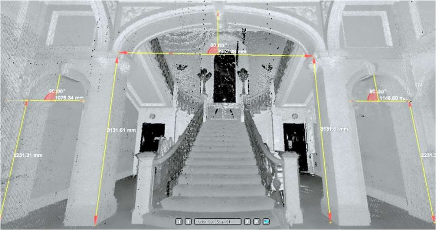
Preprints (www.preprints.org) | NOT PEER-REVIEWED | Posted: 18 January 2021                 doi:10.20944/preprints202101.0331.v1

             15    Computers & Geosciences                                                      2017                 1
             16    International Journal of Remote Sensing                                      2016                 1
                                                                                                2015                 1
             17    International Journal of Agricultural & Biological Engineering               2016                 1
             18    Engineering Geology                                                          2015                 1
                                                                                                2019                 1
             19    Geomatics & Information Science of Wuhan University                          2015                 1
             20    International Journal of Pavement Engineering                                2017                 1
             21    International Journal of Applied Earth Observation & Geoinformation          2016                 1
             22    Journal of Computing in Civil Engineering                                    2016                 1
             23    Bulletin of Engineering Geology & the Environment                            2016                 1
             24    International Journal for Light & Electron Optics                            2015                 1
             25    Archives of Photogrammetry, Cartography & Remote Sensing                     2015                 3
             26    Advanced Engineering Informatics                                             2018                 1
             27    Journal of Applied Geodesy                                                   2015                 1
             28    Measurement                                                                  2015                 1
             29    International Journal of Production Research                                 2017                 1
             30    Mathematical Problems in Engineering                                         2018                 1
             31    Journal of the Institute of Science & Technology                             2018                 1
             32    Landslides                                                                   2018                 1
             33    Annals of Botany                                                             2018                 1
             34    Computer-Aided Design & Applications                                         2019                 1
             35    Computer-Aided Design                                                        2015                 1
             36    Estuarine Coastal & Shelf Science                                            2018                 1
             37    Ecology & Evolution                                                          2018                 1
             38    Agricultural & Forest Meteorology                                            2019                 1
             39    Computers & Electronics in Agriculture                                       2017                 1
             40    Geophysical Research Abstracts                                               2019                 2
             41    Engineering Structures                                                       2016                 1
                                                       Using ‘Scan to BIM’ as search term
              1    Remote Sensing                                                                       2019         3
              2    Advanced Engineering Informatics                                                     2018         3
                                                                                                        2017         1
                                                                                                        2016         1
                                                                                                        2015         1
              3    Automation in Construction                                                           2019         2
                                                                                                        2018         3
                                                                                                        2017         4
                                                                                                        2016         1
                                                                                                        2015         1
              4    Simulation Modelling Practice & Theory                                               2015         1
              5    Journal of Architectural Education                                                   2019         1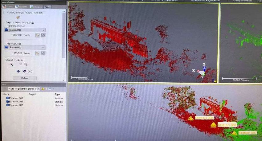
Preprints (www.preprints.org) | NOT PEER-REVIEWED | Posted: 18 January 2021                        doi:10.20944/preprints202101.0331.v1

              6    Computer-Aided Civil & Infrastructure Engineering                                            2017          1
              7    Journal of Computing in Civil Engineering                                                    2016          2
                                               Based on Table 2, a total of 88 research papers published from 2015 until January 2020
                                          were identified. These results are from a combination of ‘3D Laser Scanning’ + ’3D Pont
                                          Cloud’ and then ‘Scan to BIM’ in the Ebsco search engines.

                                                             Table 3. Emerald Results

                                       Using the term ‘3D Laser Scanning’ + ‘3D Pont Cloud’ + ‘abstract’

                                                   Journals                                            Year                 Paper

              1    International Journal of Building Pathology and Adaptation                           2018                  1
              2    Journal of Facilities Management                                                     2019                  1
              3    International Journal of Intelligent Computing and Cybernetics                       2019                  1
              4    Built Environment Project and Asset Management                                       2017                  1
              5    Engineering, Construction and Architectural Management                               2019                  1
              6    Sensor Review                                                                        2017                  1
              7    Assembly Automation                                                                  2019                  1
                                               Using ‘Scan to BIM’ + ‘abstract’ as a search term
              1    Journal of Facilities Management                                                     2019                  1
              2    Built Environment Project and Asset Management                                       2017                  1
              3    Structural Survey                                                                    2016                  1
                                               Based on Table 3, a total of 10 research papers were identified published from 2015
                                          until January 2020. These results from a combination of ‘3D Laser Scanning + ’3D Pont
                                          Cloud’ + ‘abstract’ and then ‘Scan to BIM’ + ‘abstract’ in the Emerald search engines.

                                                        Table 4. Google Scholar Results
                                           Using ‘3D laser scanning’ + ‘point clouds’ as search term
                                                   Journal                                             Year                Papers
              1     Pattern Recognition                                                                2015                   1
              2     Automation in Construction                                                         2019                   1
              3     European Journal of Remote Sensing                                                 2016                   1
              4     Sensors                                                                            2017                   1
              5     Applied Mechanics and Materials                                                    2015                   1
              6     American Journal of Engineering Research                                           2018                   1
              7     IEEE Access                                                                        2018                   1
              8     Revista de la Facultad de Ingeniería U.C.V                                         2017                   1
              9     Bulletin of Surveying and Mapping                                                  2017                   1
              10    Computer Science                                                                   2016                   1
              11    Journal of Shandong University of Technology                                       2017                   1
              12    Metal Mine                                                                         2017                   1
              13    Nonferrous Metals Science and Engineering                                          2017                   1
              14    Journal of Wuhan University of Technology                                          2017                   1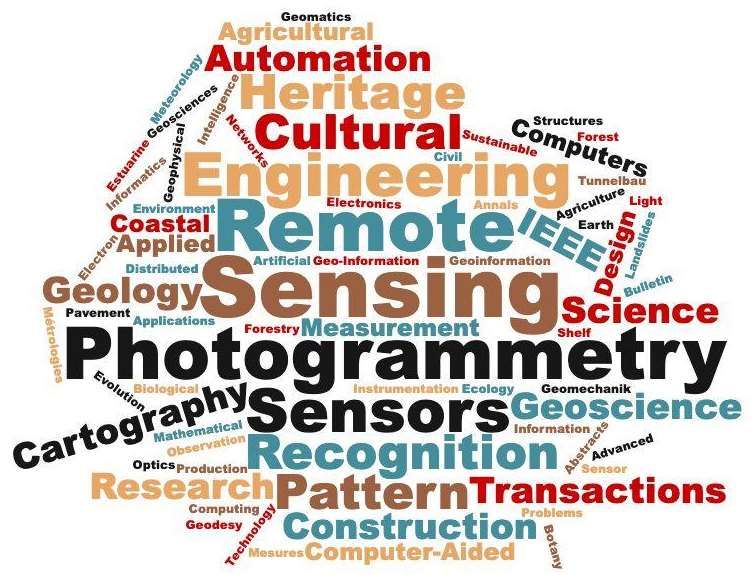
Preprints (www.preprints.org) | NOT PEER-REVIEWED | Posted: 18 January 2021                       doi:10.20944/preprints202101.0331.v1

              15    ISPRS Journal of Photogrammetry and Remote Sensing                                 2019                     1
              16    Construction Management and Economics                                              2015                     1
                                                      Using “Scan to BIM” as search term
              1    Automation in Construction                                                          2015                     1
              2    The International Archives of the Photogrammetry, Remote Sensing                    2019                     3
                   and Spatial Information Sciences                                                    2017                     1
              3    Advanced Engineering Informatics                                                    2018                     1
              4    Architectural Engineering and Design Management                                     2019                     1
              5    Architecture and Civil Engineering                                                  2016                     1
              6    Virtual Archaeology Review                                                          2019                     1
              7    Geo Business                                                                        2015                     1
              8    European Real Estate Society                                                        2019                     1
              9    Construction Research Congress                                                      2018                     1
             10    Remote Sensing                                                                      2019                     2
                                             Based on Table 4, a total of 16 research papers published from 2015 until January 2020
                                        were identified. These results are from a combination of “3D Laser Scanning +3D Pont
                                        Cloud” and then “Scan to BIM” in the Google Scholar search engines.
                                             Given that the aim of the systematic review was to understand the evolution of re-
                                        search in 3D point cloud and 3D laser scanning, it is imperative to investigate trends in
                                        various disciplines and areas of applications. To gain insights into the application of 3D
                                        laser scanning in the different domains, a word cloud was generated from all the articles
                                        obtained using ‘3D Laser Scanning’ + ‘3D Pont Cloud’. The result is presented in Figure 1.

                                        Figure 1. Word cloud from the 4 databases obtained using the search terms ‘3D Laser Scanning’ +
                                        ‘3D Pont Cloud’
                                             Based on Figure 1, the result shows that the application of laser scanning in
                                        ‘construction’ as a discipline is very limited. This can be seen at the bottom of the point
                                        cloud above. For example, The European Journal of Remote Sensing and The American
                                        Journal of Engineering Research discuss the density and the size of point cloud data in the
                                        natural environment with the focus on forest and vegetation. Furthermore, IEEE Access
                                        and sensors explore point cloud data, its intensity and use in tunnel inspections.
                                        Moreover, Applied Mechanics and Materials and Revista de la Facultad de Ingeniería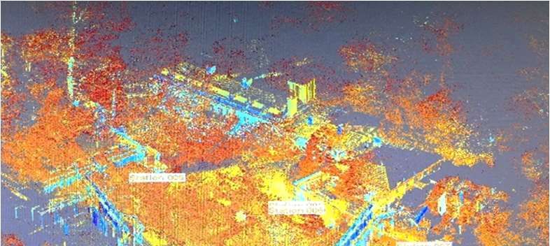
Preprints (www.preprints.org) | NOT PEER-REVIEWED | Posted: 18 January 2021                   doi:10.20944/preprints202101.0331.v1

                                    U.C.V focus on the methods of processing point cloud data using software such as
                                    Geomagic and Cyclone for diagnostics and registration. Nonferrous Metals Science and
                                    Engineering also focused on point cloud data processing, while Computer Science
                                    discussed the display speed of point cloud data for visualisation purposes. Metal Mine
                                    proposed a method to automatically extract boundary features of a surface from the point
                                    cloud data. Finally, Automation in Construction, Pattern Recognition, and Construction
                                    Management and Economics overlap with the results from Science Direct.
                                         The word cloud in Figure 1 shows that the literature focuses on the technical side of
                                    3D point cloud and 3D laser scanners as the main journals are on remote sensing,
                                    photogrammetry, and sensors, while published papers in the construction field is limited.
                                         To gain insights into the application of 3D laser scanning, a word cloud was
                                    generated from all the articles obtained using ‘Scan-to-BIM’, as shown in Figure 2.

                                    Figure 2. Word cloud from the 4 databases obtained using the search term: “Scan-to-BIM”
                                         It can be inferred from Figure 2 that 3D laser scanning applications are quite common
                                    in construction practice as a process. In addition to the findings that emerged from the
                                    systematic review presented and discussed in Tables 1, 2, 3 &4 and Figures 1 &2, a detailed
                                    examination of the articles also revealed some interesting results. This include:
                                    Automated processing of point cloud data based on material and colour, which identifies
                                    topologies (building elements) based on texture, intensity value, and RGB colour space
                                    that aims to identify the spatial relationships between building elements and their surface
                                    properties (Wang and Kim, 2019). Additionally, Xiong’s et al. work attempts to
                                    automatically identify walls, floors, ceilings, and any significant rectangular openings
                                    (e.g., doorways and windows) (Xiong, Adan, Akinci and Huber, 2013). All this can lead
                                    to imprecise quality assurance and progress estimates, which was mentioned by Chen and
                                    Cho (2019) as concerning visibility issues in Scan to BIM applications. Additionally, the
                                    relationship of point cloud intensity, the processing and the quality of data (Fryskowska
                                    and Stachelek, 2018).
                                    3.2. Field Survey: point-cloud model develpoment
                                         The following field survey is the core of the ‘proof-of-concept’ approach used for this
                                    study and was imperative to describe the case study building and the technologies used
                                    in data acquisition and analysis. The Headington Hill building, a historic mansion built in
Preprints (www.preprints.org) | NOT PEER-REVIEWED | Posted: 18 January 2021 doi:10.20944/preprints202101.0331.v1
1824, and is located on the Oxford Brookes University Campus in Oxford, UK. The main
reason for selecting the building lay in the historical value of the asset and the rich detail
level on the external and internal envelope of the building. The uniqueness and the ap-
propriate scale of the building allowed the collection of sufficient data from the scans to
examine the feasibility and accuracy of the 3-D laser scanning device. The aerial view is
presented in Figure 3.
West Elevation
Headington Hill
Building
Main Hall
South Elevation
Figure 3. 3D model and aerial view of Headington Hill Building
The main surveying equipment used was 3D laser scanner, Trimble TX8 mark. The
key technical specifications of Trimble TX8 are listed in Table 5.
Table 5. the technical specifications of Trimble TX8 Laser Scanner
Scan Parameter Trimble TX8 Specifications
Maximum range (m) 120 m
Minimum range (m) 0.6 m
Field of view (degree) 360°X317° degree
Scanning Speed 1Milion point/second
Scan Duration (seconds) 60 second
Scan Accuracy (mm)Preprints (www.preprints.org) | NOT PEER-REVIEWED | Posted: 18 January 2021 doi:10.20944/preprints202101.0331.v1
Having examined the case study building to accomplish this ‘proof-of-concept’
method, the following framework will be examined. See Figure 4.
Data Processing
Revit
Trimble TX8
Data Registration
Scanning
Transmission to
Data Export
Exterior Scans
Data Organization Sketch up
Interior Scans
Data De-noising CAD
Software
Figure 4. Cloud-data Examination Framework
The first step was to capture the building data using the Trimble TX8. This involves
exterior and interior scans with different characteristics in term of station point distance,
number of cloud points, level of detail and level of accuracy. The scanning strategy was
based on the positioning of the scanning device to capture the external envelope of the
building and formulate a coherent 3-D model through capturing the external elevations
of the building from various stations with different angles, distances, and heights. The
interior scanning strategy was based on scanning the internal spaces of the building in
separation, then merging the scanned spaces into a single model that represents the inter-
nal envelope of the building. Interior scans are classified by floor level and involves a
number of scans that shape the 3-D model of the floor. Common spaces with double floor
heights were scanned from various points and floor levels to formulate a unified cloud
model that illustrates the spaces without the duplications of cloud points.
3.2.1. Scanning Process
The surveying was conducted in two phases, one each for the exterior envelope and
interior spaces of the building. Phase 1 was conducted through five station points sur-
rounding the exterior elevations to shape a comprehensive field of view and enable the
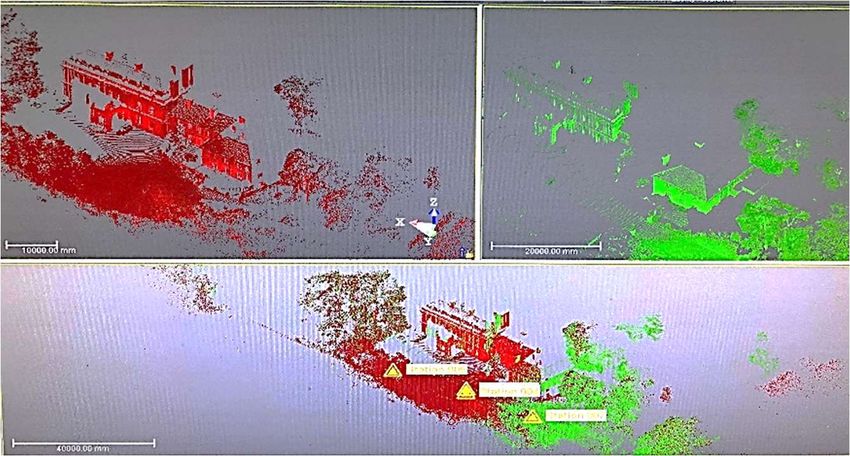
device to identify and integrate the external surfaces. Figure 5 shows station points loca-
tion on site. Station A and station B cover the western elevation, while station D, C, E cover
eastern elevation. Station A, C together cover southern elevation and station E covers the
apparent part of the northern elevation. The station points were placed in different dis-
tances from the nearest building surface. Station A was 15.5 m away from the nearest sur-
face, while station C was 6.5 m away from the nearest surface. Station D recorded the
farthest distance of 22.5 m. The variation in point distances relates to the desired angle,
field of view of the scans and the existing site situation, limits, and obstacles.Preprints (www.preprints.org) | NOT PEER-REVIEWED | Posted: 18 January 2021 doi:10.20944/preprints202101.0331.v1
Figure 5. External scanning points placement on the Headington Hill building site
Noticeably, the distance between the station point and the nearest building surface
affected the cloud points number of each scan. The cloud points acquired from station A
scan was at a distance of 1.5M, while cloud points of station C and E were 11M and 34M
respectively. Table 6 demonstrates the distances of the stations along with the acquired
cloud points from each station.
Table 6. list of acquired cloud points of external scans along with station points distances
Station Distance from nearest building surface (meters) Cloud Points
Station A 15.5 m 1,035,939
Station B 20 m 1,178,415
Station C 6.5 m 1,428,007
Station D 22.5 m 1,072,529
Station E 13.6 m 1,389,529
Phase 2 was conducted in two stages, stage one focused on the ground floor of the
building where 7 station points were utilized to obtain cloud data for the main hall, com-
mon areas, and rooms. Stage two focused on the first floor where 5 station points were
placed to scan the main hall ceiling, major staircase, and upper floor common areas to
integrate these scans with the ground floor cloud data. Figure 6 shows the distribution of
the station points on the ground and first floor levels of the building. It is of note that scans
were only conducted on accessible areas of the building.
(a) Ground Floor Plan (b) First Floor Plan
Figure 6. Headington Hill building plan: (a) ground floor plan; (b) first floor main hall plan
Although, the distance variations between the surfaces and station points in exterior
scanning affected the cloud points density, this effect appeared less in interior scanning
because of the similarity of distances from the nearest internal surface making the point
cloud much denser and more more complex than the external scans. See Table 7.Preprints (www.preprints.org) | NOT PEER-REVIEWED | Posted: 18 January 2021 doi:10.20944/preprints202101.0331.v1
Table 7. lists acquired cloud points of internal scans along with station points distances
Station Distance from nearest building surface (meters) Cloud Points
(millions)
Station 1 3m 1,879,252
Station 2 4.5 m 1,864,804
Station 3 2.5 m 1,865,083
Station 4 3.5 m 1,857,055
Station 5 4m 1,861,777
Station 6 2m 1,843,463
Station 7 3.5 m 1,873,135
Station 8 5m 1,875,792
Station 9 5m 1,878,262
Station 10 5m 1,835,489
Station 11 4.5 m 1,894,394
Station 12 4.5 m 1,895,844
3.2.2. Exporting Scanning-data: Trimble TX8 to Trimble Realworks
This step involves importing the captured data from a USB flash in the TX8 into a
point cloud processing software, which in the case of this study is Trimble Realworks.
3.2.3. Point Cloud Processing
The scanned stations acquired through survey were processed in a software compat-
ible with Trimble TX8 scanner namely, Trimble Realworks software. Data processing was
conducted in three stages; stage 1 related to cloud data registration, while stage 2 involved
filtering registered data and stage 3 was concerned with investigating the resulting cloud
model. Each stage will be discussed in more detail in the ensuing sections.
3.2.3.1. Point Cloud Registration
The first step in processing cloud data is registering the cloud stations acquired
throughout the surveying process. The registration process was conducted through two
phases, phase 1 refers to external scans while phase 2 focuses on internal scan registration.
Station registration is based on two methods, either cloud-based registration (clouds reg-
istered according to surfaces matchings or proximities) or target-based registration
(clouds registered according to a selected reference plane, sphere or object). Cloud-based
registration was utilized in registering the cloud points, the registration was conducted
through two stages. Stage 1 concerned with an automatic registration of cloud points
based on surface matching by which cloud points were identified, and registered. Auto-
matic cloud registration specifies properties of each cloud station such as point density,
station height, matching errors, cloud point number and cloud stations clashes. Figure 7
illustrates the results of automatic cloud points registration.Preprints (www.preprints.org) | NOT PEER-REVIEWED | Posted: 18 January 2021 doi:10.20944/preprints202101.0331.v1
Figure 7. Automatic Point Cloud Registration
Automatic cloud registration (stage 1) defines and registers cloud station points, sur-
faces, and volumes, therefore, these cloud stations appear as distinguished clouds merged
according to proximities of station surfaces. The resulting cloud stations necessitate an-
other stage of registration (stage 2) to organize, assemble, and establish an integrated
cloud model. Stage 2 focuses on manual cloud registration. In this stage registered cloud
stations were adjusted and organized to achieve full surface matching. Manual cloud reg-
istration methods are based on selecting a reference cloud station and a moving cloud
station where the latter can be moved, rotated, and adjusted to match shared surfaces of
the reference cloud station. Manual registration provides a surface matching test between
the two stations, where matching test result with acceptable low error (usuallyPreprints (www.preprints.org) | NOT PEER-REVIEWED | Posted: 18 January 2021 doi:10.20944/preprints202101.0331.v1
1 2 3
Complete Cloud-model
4 5 6
Figure 9. Point Cloud Registration stages: (1) automatic registration; (2,3,4,5,6) manual registration
Figure 10. Headington Hill building exterior cloud model
3.2.3.2. Point Cloud De-noising
3-D laser scanners capture and scans all physical objects that appear in the field of
view during the scanning process. For instance, the Trimble TX8 captures all existing ob-
jects on site such as moving objects, plants and trees, neighbouring buildings, and the
surrounding environment.
All these objects add massive points to the cloud, complicating the cloud model and
point cloud production due to the extensive point number resulting from unwanted ob-
jects. Some objects create barriers and visual obstacles to the model, and therefore require
visual treatment to produce a clear, understandable cloud model. De-noising refers to the
process of excluding undesirable physical objects captured during the scanning process.
In this paper, the purpose of point cloud de-nosing was to:
Reduce cloud points through eliminating undesirable objects, neighboring buildings,
unrelated visual context to ease and reduce time required to process scanned clouds.Preprints (www.preprints.org) | NOT PEER-REVIEWED | Posted: 18 January 2021 doi:10.20944/preprints202101.0331.v1
Extract visual barriers overlaying building elevations, interior spaces, and surfaces to
obtain a clear, functional field of view.
Decrease cloud model complexity and focus on cloud model components.
The de-noising process was conducted through two methods provided by the Trim-
ble Realworks software as the following:
Regional de-noising: enables eliminating large areas such as surrounding environment
and neighboring buildings.
Segmental de-noising: enables eliminating single objects, undesirable existing elements
on site and visual barriers.
Figure 11 presents exterior and interior cloud model of Headington Hill building
prior de-nosing the cloud model and after implementing de-noising methods.
Reginal de-noising
(a) (b)
Segmental de-noising
Segmental de-noising
(a) (b)
Segmental de-noising
Figure 11. Point cloud de-noising: (a) prior de-noising; (b) after de-nosing
Point cloud de-noising decreases complexity, volume of cloud model through elimi-
nating the un-desirable physical object. Exterior cloud de-noising in the case study
showed higher points reduction due to the massive points acquired from various elements
on site, while interior cloud de-noising showed lower points reduction due to contextual
limits of interior scans. Table 8 lists cloud points prior and after cloud de-noising as well
as redacted points from each cloud model.
Table 8. Cloud points prior and after cloud de-noising
Cloud Model Cloud points prior de-noising Cloud points after de-noising Redacted points
Exterior Model 8,224,818 4,093,981 4,130,837
Interior Model 52,278,405 50,127,390 2,0151,015
3.2.3.3. Point Cloud InvestigationPreprints (www.preprints.org) | NOT PEER-REVIEWED | Posted: 18 January 2021 doi:10.20944/preprints202101.0331.v1
After registering and de-noising cloud stations, the acquired cloud model was inves-
tigated by set of tools provided in the Trimble Realworks software. The aim of the inves-
tigation was to test reliability and accuracy of the resulting cloud model. Point cloud in-
vestigation was conducted for two main principles in 3-D laser scanning, the first principle
related to the tools and options of measuring cloud models as well as accuracy of the
measurement. The second principle related to the penetrability of laser beams through
building elements.
Realworks software provides various measurement tools including basic measure-
ment means such as horizontal and vertical measurement as well as advanced tools such
as angular, plane, and geometry measurements. Points in the cloud formed reference
points for measurement, where, in a distance between (5mm-10mm) a point was tangible
as reference of measurement. Selected reference points were connected with another tan-
gible point to generate the readings. In Figure 12, main hall elements were measured, no-
ticeably areas with low intensity of points showed errors in measurement between
(10mm-20mm), while areas with high intensity of points showed accurate readings. The
reason of various measurement readings lay in the intensity of scanned points on different
surfaces, where Areas with higher number of points showed more accurate readings.
Figure 12. Inveistigation of the main hall elements of Headington Hill building
Another aspect of the investigation was testing penetrability of the Trimble TX8 laser
beams through various surfaces. Trimble TX8 generates laser beams with diameters of 6-
10-34mm based on the distance from the nearest surface. Laser beams penetration through
building elements such as walls, ceilings, structural elements was limited due to material
specifications of these elements. The building facade was included large stones blocks
with thickness of up to 600 mm that forms the external façade of the building. The nature
and specifications of the external walls as well as internal walls, ceilings, and structural
elements obstructed laser beams penetration. Figure 13 illustrates penetrability of laser
beams through different surfaces, (b) represents laser penetration in the glass roof of the
main hall, noticeably laser beams penetrate through low point intensity areas as showed
in the points test, (c) represents laser penetration through the roof structure of the main
hall, the points test shows limited penetration and high reflection of laser beams. As a
result, the penetrability test has indicated that opaque materials with high point intensity
reflect laser beams, while transparent materials with low point intensity are penetrated by
the beams. The Point cloud investigation has indicated a relationship between scannedPreprints (www.preprints.org) | NOT PEER-REVIEWED | Posted: 18 January 2021 doi:10.20944/preprints202101.0331.v1
point intensity, accuracy of measurement readings, and penetrability of laser beams.
Surfaces with higher points intensity showed accurate readings and high reflectivity for
laser beams, while surfaces with lower point intensity showed minor errors in reading
and higher penetrability for laser beams.
(a)
Glass 90% penetrated
Low points Density
(b)
Roof
Intensity area
Roof 90% reflected
High points Density
(c)
structure 10% penetrated (d)
Intensity area
Figure 13. (a) original photograph; (b) main hall glass roof; (c) main hall roof structure; (d)
penetrability test
3.3. Cloud Model Integration with BIM
The point cloud process generated a unified, integrated cloud model which was a
result of linking and merging several point clouds. The created cloud model was
integrated with BIM applications by exporting cloud the model to CAD software, then
applicable BIM strategies were investigated on the model. Trimble Realworks provides
two main methods of integrating cloud model with BIM applications. The methods of
exporting cloud model are listed below:
Built-in Plugin: a plugin provided by Trimble Realworks enables direct export of
cloud model to SketchUp software.
Cloud Export: a method enables exporting cloud model to other file formats compati-
ble with various software.
Trimble Realworks enables exporting a cloud model in various file formats. Table 9
lists commonly used file formats in CAD software, as well as, exporting availability in
Trimble Realworks along with compatible software for these formats and format integra-
tion with BIM applications.
Building on Table 9, all other file formats that can allow interoperability between the
software involved in the 3D printing process are presented in Table 10.
Table 9. key file formats in CAD with exporting availability of these formats in Trimble Realworks
File Format Availability Compatible Software BIM Applications
DWG Available AutoCAD Suite, Revit Required
DXF Available AutoCAD Suite, Revit Upon request
IFC Not available Revit, Costx, Navisworks Required
SKP Built-in plugin SketchUp, 3ds Max, Revit Upon request
OBJ Available 3ds Max Upon request
KMZ Available Google Earth Upon requestPreprints (www.preprints.org) | NOT PEER-REVIEWED | Posted: 18 January 2021 doi:10.20944/preprints202101.0331.v1
FBX Available 3ds Max, AutoCAD Suite Upon request
PDF Not available Adobe Acrobat, AutoCAD Suite Upon request
DGN Available AutoCAD Suite, Revit Upon request
ACIS Not available AutoCAD Suite Upon request
Table 10. Interoperable file formats between different 3D printing related software systems
3D-laser scanner Software File in (input to software) File out (output from
software)
Trimble TX Trimble Realworks RWP, XYZ, E57, LAS, LAZ, ZFS, RSP, E57, ASC, LAS 1.2, LAS 1.4,
3D laser scanner dependant
[Data output format FLS, DP, PTX, PTS LAZ, POD, PTS, PTX, TZF,
(RWP)] BSF, KMZ, DWG, DXF,
DGN, FBX, OBJ
software
FARO [Data output FARO Scene FLS, XYZ, CVS, COR, CPE PTC, PTX, PST, XYZ, DXF,
format (FLS)] IGES, VRML, E57
Leica [Data output Leica Cyclone XYZ, PTS, PTX, LAS, E57, ZFS, DP XYZ, PTS, PTX, E57, DXF,
format (PTX and PCI/CWF, DBX, gbXML
PTS)]
LiDAR360 LiData, las, laz, asc, neu, xyz, pts, csv, ply LiData, las, laz, asc, neu,
3D laser scanner non
xyz, pts, csv, ply
dependant software
PolyWorks IGES, STEP, DXF, JT, OBJ, PLY, POL, STL, IGES, STL, DXF
VRML 2.0
Point Cloud based software
PointCab dp, e57, asc, fws, lsproj, fls, las, laz, lsdx, dwg, dxf, dae, 3ds
lse, dae, 3ds, ifc, stl, mpc, ply, ptg, ptx,
rps, pvtp, vtp, xyz, zfs, .zfprj
Autodesk Recap ASC, CL3, CLR, E57, FLS, FWS, ISPROJ, RCS, RCP, PCG, PTS, E57,
LAS, PCG, PTG, PTS, PTX, RDS, TXT, DXF, DWG
XYB, XYZ, ZFS, ZFPRJ, DXF, DWG
Autodesk Revit DWG, RVT, DXF, gbXML, RCP, DWF DWG, DXF, gbXML, FBX,
BIM Based tools
DGN, ACIS, IFC
Bentley POD, OBJ, SHP, DXF, DWG, ESRI, E57, POD, PTS, XYZ
ZFS, LAZ, LAS, FLS, FWS, XYZ, PTS,
PTX, PTZ, TXT, LWO, CL3, BIN, RSP,
3DD
ArchiCAD DWG, IFC, 3DS, 3DM, SKP, KMZ, STL, PDF, DWF, DXF, DWG,
PDF, DXF DGN
visualisation
FARO SCENE WebShare rcp, pod, xyz, e57
Web-based
Leica PegasusPreprints (www.preprints.org) | NOT PEER-REVIEWED | Posted: 18 January 2021 doi:10.20944/preprints202101.0331.v1
Flyvast LAS, LAZ, XYZ, PTX, PLY, OBJ FLY, dxf, shp
Voxxlr IFC, Dxf, e57, pts, ply, las, laz
Noticeably, Trimble Realworks lacks the ability to export cloud model in the IFC file
format (Industry foundation classes) which is commonly utilized in exchanging BIM
models. The absence of the IFC file format requires third-party software, in this case Revit,
to generate IFC file formats for cloud models to integrate with specific software such as
Costx, Navisworks that are essential for implementing BIM strategies.
The resulting case study cloud model was exported in DWG file format and imported
into the Revit software that is commonly used for BIM applications. In Revit, the cloud
model was recognized as a 3D asset formed by millions of points, these points were visible
but intangible (not solid or physical). Revit generated horizontal, vertical sections for the
model as well as elevations, 3-D navigation. Figure 14 (a&b) illustrate the eastern elevation
as well as the cross section of the main hall of Headingtion Hill building, as shown below.
Figure 14. (a) Eastern elevation of Headington Hill Building; (b) Cross-section of the main hall
Generating drawings from the cloud model was the first step in attaining cloud
model integration with BIM applications. The resulting drawings can be utilized in docu-
menting the historical building. Furthermore, the drawings were measurable, accurate
and exportable to other BIM software programs. Revit was only considered a third-partyPreprints (www.preprints.org) | NOT PEER-REVIEWED | Posted: 18 January 2021 doi:10.20944/preprints202101.0331.v1
software in this study by which IFC formats were established from the cloud model and
enabled complete integration with other BIM applications such as Costx which is a spe-
cialist program in quantity take-off. Hence, material quantities in the building can be cal-
culated, investigated, and analysed. Another possible application, is the use of structure
analysis software which analyses the physical condition of the building and indicates de-
fect points in the structure. Such data can be used in rehabilitating historical buildings or
renovating external or internal envelopes and for documentation purposes of historic
buildings. Also, the IFC cloud model data is crucial for the facility management of build-
ings. Additionally, BIM applications can expand to cover maintenance issues in the build
environment. The acquired IFC model can be used in the maintenance process. Regular
and advanced maintenance activates to be modeled and tested in the cloud model before
implementation. Figure 15 demonstrates BIM applications of cloud models using third-
party software.
Figure 15. Cloud model integration with BIM applications
4. Findings and Discussion
This study has yielded 3 main findings. Firstly, despite the multiple applications of
laser scanning alongside BIM in the existing research, most studies focus on the process
after the point cloud data exportation, with little attention being given to the acquisition
of the data itself. Therefore, it becomes imperative to further examine the data acquisition
phase. Additionally, to ensure the direct communication or exchange of data in the
scanning workflow, software and hardware requirements, and their interoperability
within the BIM system have been examined and presented in Table 10.
Secondly, the intensity of point cloud data before and after the de-nosing process
varies significantly for exterior 3D point cloud models compared to the interior. The de-
noising process of the case study has shown that for the exterior, the number of point
clouds was decreased by 50%, while for the interior there was a reduction of less than 1%.
Lastly, the penetrability of laser beams through various surface materials depends
on the surface material of various building components such as walls, columns, and
windows. For example, stone used for exterior walls showed a much higher penetration
rate compared to glassed surfaces. This could be interpreted incorrectly for auto detection
of various building elements or surfaces based on the intensity of surface material as it
was in this case where the colour of the arcade space was the same as the glass roof.
5. ConclusionPreprints (www.preprints.org) | NOT PEER-REVIEWED | Posted: 18 January 2021 doi:10.20944/preprints202101.0331.v1
This study has examined the applications of 3D laser scanners in construction. A
systematic review and a proof-of-concept method were used in this study to shed light on
various factors influencing the use of laser scanner and their integration into BIM. It was
found that, despite the recent interest in 3D laser scanners, research on its applications are
still lagging in the construction field compared to other disciplines. Furthermore, it
emerged that most studies have seldom focused on the data processing phase. Also, this
study has found that issues with intensity quality of point cloud data vis-à-vis the position
of 3D laser stations revealed through de-noising. Lastly, the study revealed issues around
the penetrability of laser beams through various surface materials. As this is a crucial issue
for automated detection of various building elements that could be used for automated
progress monitoring and detection of discrepancy in construction. These findings reveal
the need for further exploratory research to be conducted in the field of 3D laser scanning
applications in construction practice.
6. References
1. Bosché, F., Ahmed, M., Turkan, Y., Haas, C.T. and Haas, R., 2015. The value of inte-
grating Scan-to-BIM and Scan-vs-BIM techniques for construction monitoring using
laser scanning and BIM: The case of cylindrical MEP components. Automation in
Construction, 49, pp.201-213.
2. Díaz-Vilariño, L., Frías, E., Balado, J. and González-Jorge, H., 2018. Scan planning
and route optimization for control of execution of as-designed BIM. International Ar-
chives of the Photogrammetry, Remote Sensing & Spatial Information Sciences.
3. Campi, M., di Luggo, A. and Scandurra, S., 2017. 3D modeling for the knowledge of
architectural heritage and virtual reconstruction of its historical memory. The Inter-
national Archives of Photogrammetry, Remote Sensing and Spatial Information Sciences, 42,
p.133.
4. Chan, D.W., Olawumi, T.O. and Ho, A.M., 2019. Perceived benefits of and barriers to
Building Information Modelling (BIM) implementation in construction: The case of
Hong Kong. Journal of Building Engineering, 25, p.100764.
5. Cheng, L., Chen, S., Liu, X., Xu, H., Wu, Y., Li, M. and Chen, Y., 2018. Registration of
laser scanning point clouds: A review. Sensors, 18(5), p.1641.
6. Fassi, F., Fregonese, L., Ackermann, S. and De Troia, V., 2013. Comparison between
laser scanning and automated 3d modelling techniques to reconstruct complex and
extensive cultural heritage areas. International archives of the photogrammetry, remote
sensing and spatial information sciences, 5, p.W1.
7. Fröhlich, C. and Mettenleiter, M., 2004. Terrestrial laser scanning–new perspectives
in 3D surveying. International archives of photogrammetry, remote sensing and spatial
information sciences, 36(Part 8), p.W2.
8. Fryskowska, A. and Stachelek, J., 2018. A no-reference method of geometric content
quality analysis of 3D models generated from laser scanning point clouds for
hBIM. Journal of Cultural Heritage, 34, pp.95-108.Preprints (www.preprints.org) | NOT PEER-REVIEWED | Posted: 18 January 2021 doi:10.20944/preprints202101.0331.v1
9. Göçer, Ö., Hua, Y. and Göçer, K., 2016, October. A BIM-GIS integrated pre-retrofit
model for building data mapping. In Building Simulation (Vol. 9, No. 5, pp. 513-527).
Tsinghua University Press.
10. Guidi, G., Russo, M. and Angheleddu, D., 2014. 3D survey and virtual reconstruc-
tion of archaeological sites. Digital Applications in Archaeology and Cultural Herit-
age, 1(2), pp.55-69.
11. Ham, Y. and Golparvar-Fard, M., 2015. Mapping actual thermal properties to build-
ing elements in gbXML-based BIM for reliable building energy performance model-
ing. Automation in Construction, 49, pp.214-224
12. Hichri, N., Stefani, C., De Luca, L., Veron, P. and Hamon, G., 2013. From point cloud
to BIM: a survey of existing approaches.
13. Jalaei, F., Zoghi, M. and Khoshand, A., 2019. Life cycle environmental impact assess-
ment to manage and optimize construction waste using Building Information Mod-
eling (BIM). International Journal of Construction Management, pp.1-18.
14. Kim, M.K., Wang, Q., Park, J.W., Cheng, J.C., Sohn, H. and Chang, C.C., 2016. Auto-
mated dimensional quality assurance of full-scale precast concrete elements using
laser scanning and BIM. Automation in Construction, 72, pp.102-114.
15. Lagüela, S., Díaz-Vilariño, L., Armesto, J. and Arias, P., 2014. Non-destructive ap-
proach for the generation and thermal characterization of an as-built BIM. Construc-
tion and Building Materials, 51, pp.55-61.
16. Lagüela, S., Díaz-Vilariño, L., Martínez, J. and Armesto, J., 2013. Automatic thermo-
graphic and RGB texture of as-built BIM for energy rehabilitation purposes. Automa-
tion in Construction, 31, pp.230-240.
17. Larsen, J.K., Shen, G.Q., Lindhard, S.M. and Brunoe, T.D., 2016. Factors affecting
schedule delay, cost overrun, and quality level in public construction projects. Jour-
nal of Management in Engineering, 32(1), p.04015032.
18. Maalek, R., Lichti, D.D. and Ruwanpura, J.Y., 2019. Automatic recognition of com-
mon structural elements from point clouds for automated progress monitoring and
dimensional quality control in reinforced concrete construction. Remote Sens-
ing, 11(9), p.1102.
19. Nocerino, E., Menna, F. and Remondino, F., 2014. Accuracy of typical photogram-
metric networks in cultural heritage 3D modeling projects. International Archives of
the Photogrammetry, Remote Sensing & Spatial Information Sciences, 45.
20. Omar, H., Mahdjoubi, L. and Kheder, G., 2018. Towards an automated photogram-
metry-based approach for monitoring and controlling construction site activities.
Computers in Industry, 98, pp.172-182.
21. Pärn, E.A. and Edwards, D.J., 2017. Conceptualising the FinDD API plug-in: A study
of BIM-FM integration. Automation in Construction, 80, pp.11-21.
22. Pica D. & Abanda F.H. (2019) Emerging BIM-3D-Laser Scanning Integration in Con-
struction Practice. In: The 11th International Conference (CITC-11), Construction in
the 21st Century, September 9-11, 2019, London, UK
23. Remondino, F., 2011. Heritage recording and 3D modeling with photogrammetry
and 3D scanning. Remote sensing, 3(6), pp.1104-1138.You can also read