Recent Trends In the South China Sea Disputes
←
→
Page content transcription
If your browser does not render page correctly, please read the page content below
Recent Trends
  In the South China Sea
                          Disputes

                             By Boston Global Forum
                                    June 2015

The report is derived from Boston Global Forum conferences and is produced by the
Boston Global Forum (BGF) in cooperation with the Center for International Studies,
University of Social Sciences and Humanities, Ho Chi Minh City (SCIS) and the South
China Sea Chronicle Initiative.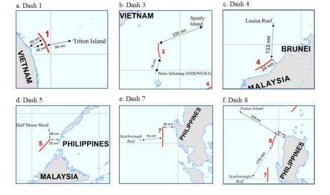
Table of Contents

INTRODUCTION ....................................................................................................................................................................... 1
1.       SOUTH CHINA DISPUTES ........................................................................................................................................... 1
     1.2           Islands ....................................................................................................................................................................... 1
     1.2           Maritime delimitation ........................................................................................................................................ 3
     1.3           Freedom of navigation ....................................................................................................................................... 6
2.       POLICY RECOMMENDATIONS .................................................................................................................................. 8
     2.1           ASEAN-Intra Solution ......................................................................................................................................... 8
         a. Avoiding the misfortune of non-appearance ................................................................................................. 9
         b. Facing the situation of non-appearance ........................................................................................................ 10
     2.2           US-ASEAN’s cooperative patrols .................................................................................................................. 11
     2.3           SCS Threat Index and SCS Monitor: Approaches and Methodologies .......................................... 12
APPENDIX ................................................................................................................................................................................. 14
     Appendix 1 - The use or Threat of Force in the South China Sea Disputes since 1945: A Timeline
     .................................................................................................................................................................................................. 14
     Appendix 2 - Non-exhaustive Chronologies of China’s continuous attacks on Vietnamese
     Fishermen since 2002 to June 2014 ......................................................................................................................... 28
     Appendix 3 - Case: Default of appearance and the South China Sea ........................................................... 29
     Appendix 4 – Boston Global Forum Contributors ............................................................................................... 31
         1.1           Working Group ............................................................................................................................................... 31
         1.2           Editors ................................................................................................................................................................ 31
         1.3    Participants in the Boston Global Forum Conference on Managing Peace and Security in
         the South China Sea..................................................................................................................................................... 31
INTRODUCTION
The maritime disputes in the South China Sea have recently grown more complex and heated,
given the issues at hand, the number of countries involved, and unwillingness among these
countries to genuinely cooperate with each other to find peaceful solutions to their problems.
The six countries involved: Brunei, China, Indonesia, Malaysia, the Philippines and Vietnam, all
neighbour in the South China Sea and have claimed overlapping maritime zones in the region.
All of them, save for Indonesia, claim sovereignty over maritime features in the area.
As part of the effort to ease world tensions, Boston Global Forum held several live and online
international conferences and symposia focusing on practical solutions over claims in the South
and East China Seas.
Conference participants included leading officials, scholars and policy analysts who have
studied, written, lectured and published on the issue. A list of main contributors and conference
participants is appended to this report.
1. SOUTH CHINA DISPUTES
These South China Sea disputes generally fall into three categories: (a) islands, (b) maritime
delimitation, and (c) freedom of navigation.
1.2 Islands
The large number of islands and archipelagos in the area can be categorized into three groups,
the Paracel “islands”, Macclesfield Bank including Scarborough Shoal, and Spratly “islands”.
With respect to Paracel “islands”, both Vietnam and China claim sovereignty over all maritime
features including islands, islets and reefs. On the other hand, all the maritime features in
Macclesfield Bank and Scarborough Shoal areas are claimed by both the Philippines and China.
More importantly, the Spratly “islands” can be seen as a noodle bowl of claims in which China,
Vietnam, Malaysia, Brunei and the Philippines declare their sovereignty over part or all of the
maritime features in this area.
Another aspect of the disputes relate to the legal status of the maritime features in the South
China Sea. The regime of islands, as provided in Article 121 of the United Nations Convention
on the Law of the Sea (“the Convention”) remains unclear as it governs that “an island is a
naturally formed area of land, surrounded by water, which is above water at high tide”1. The
vague terms of article 121 of the Convention, has resulted in the claimants in the South China
Sea having differing views on the application and interpretation of the article with regard to the
definition of an island. China’s position is that all the maritime features in the Paracel and
Spratly “islands” that are visible at high tide, are in China’s view islands; therefore, they are
entitled to claim not only the territorial sea surrounding them but also the Exclusive Economic
Zone (EEZ) as well as continental shelf2. The Philippines, in contrast, rejects this viewpoint.
1http://www.un.org/depts/los/convention_agreements/texts/unclos/part8.htm, access on 28 September 2014.
2 Thao, Nguyen Hong, ‘Vietnam and the Code of Conduct for the South China Sea’, Ocean Development &
International Law, vol.32, issue 2, 2001, p. 109.
1Indeed, two of the claims the Philippines brought before the arbitral tribunal under annex VII to
the Convention against China are that some of the features in Scarborough Shoal and the
Spratly area do not qualify as islands or even rocks3.
On the other hand, Vietnam, in a letter to the Secretary-General of the United Nations on 18
May 2009, has adopted the position that “the Spratly Islets do not generate exclusive economic
zones and continental shelves and that any zones around these [so called] islands should be
limited to territorial seas”4. What’s more, according to the Vietnam government, the maritime
features in the Paracel “islands” should not be given full effect5.
Malaysia and Brunei have not expressly declared their attitudes toward the legal status of those
maritime features in the Spratly “islands”. Nonetheless, owing to their claims of 200 nautical mile
EEZs based on their main coastal areas, one could assume that Malaysia and Brunei have no
interest in giving the maritime features in this area full effect or to consider them as islands6.
In short, there are two separate aspects of the disputes in the South China Sea related to those
maritime features in the area:
the dispute regarding sovereignty over the so-called islands; and
the dispute over the legal status of those islands.
While sovereignty is not a subject-matter of the United National Convention of the Law of the
Sea (UNCLOS), the dispute over the “islands” legal status is considered one of the core
concerns of UNCLOS and, as a result, falls entirely within the compulsory procedure for dispute
settlement under Part XV of the Convention.
Thus, the principle of sconsent plays a less impressive role in the judicial dispute settlement
means.
3 In the submission to the Arbitral Tribunal established under Annex VII of UNCLOS, the Philippines hold the view
that:
Michief Reef, McKennan Reef, Gaven Reef and Subi Reef are submerged features which are not above sea level at
high tide and thus do not qualify as islands or rocks in terms of Article 121 UNCLOS. None of them are located on
China’s continental shelf, while Mischief Reef and McKennan Reef are part of the continental shelf of Philippines.
China’s occupation of and construction activities on these four maritime features are unlawful and shall be
terminated. (See Republic of the Philippines (RP), Department of Foreign Affairs (DFA), Notification and Statement
of Claim (22 January 2013) Annex I, Doc B.2, Bullet points 3-5.)
Scarborough Shoal, Johnson Reef, Cuarteron Reef, and Fiery Cross Reef shall be considered as rocks under article
121(3) UNCLOS, and may only generate entitlement to a territorial sea. Having unlawfully claimed maritime
entitlement beyond 12 nautical miles from these features, China shall refrain from preventing Philippines vessels
from exploiting the living resources in the waters adjacent to Scarborough Shoal and Johnson Reef, and from
undertaking other activities inconsistent with UNCLOS at or in the vicinity of these features. (See Republic of the
Philippines (RP), Department of Foreign Affairs (DFA), Notification and Statement of Claim (22 January 2013) Annex
I, Doc B.2, Bullet points 6-7).
See also Gau, Michael Sheng-Ti, ‘Issues of jurisdiction in cases of default of appearance’, in Stefan Talmon and Bing
Bing Jia, The South China Sea Arbitration: A Chinese Perspective, Oxford and Portland, Oregon, 2014, p. 81.
4 Vietnam, Letter to Secretary-General of the United Nations, Doc. No. 240/HC-2009, New York, 18 August 2009.
5 McDorman, Ted L., ‘The South China Sea after 2009: clarity of claims and enhanced prospects for regional
Ccoperation?’, Ocean Yearbook Online, Volume 24, Issue 1, p. 517.
6 Ibid, pp. 517, 521.
21.2 Maritime delimitation
Although maritime delimitation is one of the optional exceptions to compulsory procedures
under UNCLOS7, International Courts/Tribunals have heard a number of cases on this subject.
The newest case, brought before the International Tribunal for the Law of the Sea (ITLOS) is the
dispute concerning delimitation of the maritime boundary between the Republic of Ghana and
the Republic of Côte d'Ivoire8. This is a superb example of turning to ITLOS when it comes to
resolving delimitation of maritime zones disputes, and shows how it is a good practice of
sovereign states to make use of international judicial bodies. On the other hand, the claimant
states in the South China Sea had never turned to an international court or tribunal for recourse
until 2013. That occurred when the Philippines instituted arbitral proceedings against China
based on the United Nations Conventions on the Law of the Sea (UNCLOS). This was done in
accordance with the dispute settlement provisions of UNCLOS, particularly under Annex VII,
“with respect to the dispute with China over the maritime jurisdiction of the Philippines in the
West Philippine Sea.”9 Not surprisingly, China refused to appear.
While the bilateral disputes in the region are certainly difficult, the multilateral nature of
overlapping maritime zone claims in the South China Sea adds to the complexity. Since the
South China Sea is a semi-enclosed sea, the maritime zones of the neighbouring countries
inevitably have maritime zones that overlap each other. In addition, all the claimants in this area
claim 200 nautical mile EEZs and up to 350 nautical mile continental shelves10. Nonetheless,
not every state in the South China Sea involved in a dispute has expressed a willingness to
resolve such disputes peacefully and in accordance with the procedures set out in UNCLOS.
(See table 2)
Table 2: Agreements and Submissions of ASEAN countries concerning maritime delimitation
States Documents Notes
Vietnam – Malaysia Memorandum of Understanding of 5 June Recognizing that there are
199211 overlapping area in the
Gulf of Thailand
Vietnam – Malaysia Joint Submission of information to the Recognizing “there are
commission on the limits of the unresolved disputes in the
continental shelf respecting the outer limit defined area” 13 in the
of the continental margin beyond 200 nm South China Sea
7 UNLOS, Article 298.
8 https://www.itlos.org/fileadmin/itlos/documents/press_releases_english/PR_222_EN.pdf access on 1 March 2015.
9 http://www.pca-cpa.org/showpage.asp?pag_id=1529 access on 28 September 2014.
10 Thao, Nguyen Hong and Amer, Rames, ‘A new legal arrangement for the South China Sea?’, Ocean development &
International Law, Vol. 40, Issue 4, 2009, pp. 334-335. See also, China 1998 Law on the Exclusive Economic Zone and
Continental Shelf, Articles 4 and 14; Vietnam 2013 Sea Law, Article 15; Malaysia and Vietnam Joint Submission to the
UN Commission on the Limits of the Continental Shelf in 2009; The Philippines 2009 Baseline Law; Bunei Preliminary
Submission concerning the outer limits of its continental shelf.
11 1992 Memorandum of Understanding between Malaysia and the Socialist Republic of Vietnam for the Exploration
and Exploitation of Petroleum in a Defined Area of the Continental Shelf Involving the Two Countries,
http://cil.nus.edu.sg/1992/1992-memorandum-of-understanding-between-malaysia-and-the-socialist-republic-of-
vietnam-for-the-exploration-and-exploitation-of-petroleum-in-a-defined-area-of-the-continental-shelf-involving-the-
two-c/ access on 15 February 2015.
3in the southern part of south china sea
identifying 200 nm limits12
Vietnam – Indonesia Treaty concerning the delimitation of the Establishing continental
continental shelf boundaries14 shelf boundaries in the
South China Sea.
Brunei Preliminary Submission concerning the Extending EEZ and
outer limits of its continental shelf15 continental shelf and
recognizing the future
delimitation of boundaries
with neighbours in the
future
The Philippines Instituted arbitral proceedings against the Recognizing the situation
People’s Republic of China under Annex of overlapping maritime
VII to the United Nations Convention on zones in the South China
the Law of the Sea (the “Convention”), Sea.
“with respect to the dispute with China
over the maritime jurisdiction of the
Philippines in the West Philippine Sea.
The table, illustrates two significant points must be considered. First, it could be seen that
almost all the states neighbouring the South China Sea extend their EEZs and continental
shelves mostly from their mainland. Second, those countries acknowledge the existence of a
dispute concerning maritime delimitation in the area and have, either explicitly stated or implied
that they are willing to resolve their disputes peacefully.
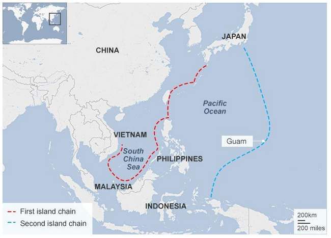
China, in particular, has attached a map to the Note Verbale with a nine-dash line that appears
to indicate its maritime claim in the South China Sea. However, in the Note Verbale of 2009,
China declared that: “China has indisputable sovereignty over the islands in the South China
Sea and the adjacent waters, and enjoys sovereignty rights and jurisdiction over the relevant
water as well as subsoil thereof16”.
At the time of this report, however, China had not officially explained its positions towards this
map. Two plausible explanations for China’s nine-dash map exist.
13 McDorman, Ted L., ‘The South China Sea after 2009: clarity of claims and enhanced prospects for regional
Ccoperation?’, Ocean Yearbook Online, Volume 24, Issue 1, pp. 507, 508
12 Joint Submission of information to the commission on the limits of the continental shelf respecting the outer limit of
the continental margin beyond 200 nm in the southern part of south china sea identifying 200 nm limits,
http://www.un.org/depts/los/clcs_new/submissions_files/mysvnm33_09/mys_vnm2009excutivesummary.pdf access
on 15 February 2015.
14 Treaty concerning the delimitation of the continental shelf boundaries,
http://www.un.org/depts/los/doalos_publications/LOSBulletins/bulletinpdf/bulletin67e.pdf access on 15 February
2015.
15 Preliminary Submission concerning the outer limits of its continental shelf,
http://www.un.org/depts/los/clcs_new/submissions_files/preliminary/brn2009preliminaryinformation.pdf access on
15 February 2015.
16 Chinese Note Verbale CML/18/2009 to the United Nations,
http://www.un.org/depts/los/clcs_new/submissions_files/vnm37_09/chn_2009re_vnm.pdf access on 13 February
2015.
4A first interpretation of the map is that China claimed sovereignty over all the maritime features
(most of them would be islands, in the South China Sea); therefore, China would be entitled to
enjoy the maritime zones, including the EEZs and continental shelves, attributed to them17.
This argument is also based on China’s domestic laws and announcement. Article 2 of the 1992
China territorial sea law and article 2 of the 1998 China EEZ and continental shelf law are two
prime examples18. In addition, China has repeated such a view in its 2011 Note Verbale stating:
“China’s Nansha Islands are fully entitled to Territorial Sea, (EEZ), and Continental Shelf”19. The
maritime zones claimed by China, according to this view, would not be generated from the main
land, but obviously from the archipelagos in the area. Second, China has expressed an interest
in the so-called “historic claims”, and the nine-dashed line map demonstrated China’s
sovereignty over the maritime spaces lying within those lines under the name of “historic water”
or “historic title”. Also in its 2011 Note Verbale, China declared that “China’s sovereignty and
related rights and jurisdiction in the South China Sea are supported by abundant historical and
legal evidence”20.
Nevertheless, whatever it is, the nine-dashed line of China illustrates undeniably that the
“maritime spaces” claimed by China overlap with its neighbours’ maritime zones extended from
their mainlands and indicate the existence of a dispute (See the Map 3)
In conclusion, the issues over maritime delimitation in the South China Sea are extremely
complicated and difficult to resolve. Such disputes cover matters that go far beyond the scope of
compulsory procedure provided in Part XV of UNCLOS. If the disputes are to be resolved
peacefully, unlikely consent by the neighboring states would be vital.
Despite the obstacles, two positive signs have emerged (1) there are more than two parties with
essential interests in the disputed maritime zones and (2) not every state in the area is opposed
to settling the dispute via peaceful means—including judicial procedure in good faith.
17 Gau, Michael Sheng-Ti (2014), Issues of Jurisdiction in Cases of Default of Appearance, The South China Sea
Arbitration: A Chinese Perspective, Stefan Talmon and Bing Bing Jia, Oxford and Portland, Oregon, 2014, p. 88
18 1992 Law of the People's Republic of China Concerning the Territorial Sea and the Contiguous Zone, article 2: “The
land territory of the People's Republic of China includes the mainland of the People's Republic of China and its
offshore islands, Taiwan and all islands appertaining thereto including the Diaoyu Islands; the Penghu Islands; the
Dongsha Islands; the Xisha Islands; the Zhongsha Islands and the Nansha Islands; as well as all the other islands that
belong to the People's Republic of China”. 1998 Law on the Exclusive Economic Zone and the Continental Shelf of the
Republic of China, article 2: “The exclusive economic zone of the Republic of China denotes the sea area contiguous
to the outer limits of the territorial sea and to a distance measuring outwardly 200 nautical miles from the baseline of
the territorial sea. The exclusive economic zone prescribed in the preceding paragraph comprises the water body, the
seabed and the subsoil. The continental shelf of the Republic of China is the submarine area that extends beyond its
territorial sea through the natural prolongation of its land territory to the outer edge of the continental margin. The
submarine area prescribed in the preceding paragraph comprises the seabed and subsoil.”
19 Permanent Mission of the People’s Republic of China, Note Verbale CML/8/2011, April 14, 2011, available from
DOALOS at: http://www.un.org/Depts/los/clcs_new/submissions_files/mysvnm33_09/chn_2011_re_phl_e.pdf.
20 Permanent Mission of the People’s Republic of China, Note Verbale CML/8/2011, April 14, 2011, available
fromDOALOS at: http://www.un.org/Depts/los/clcs_new/submissions_files/mysvnm33_09/chn_2011_re_phl_e.pdf.
5Map 3: Distance between dashes and land features21
1.3 Freedom of navigation
Freedom of navigation is an often overlooked issue in the South China Sea.
This principle, “generated by Grotius in the 17th century22 and is still being respected”23, simply
means that the sea is open to all nations to freely navigate and fish. It is considered as “one of
the pillars of the law of the sea and was at the origin of modern international law 24”. More
importantly, any disputes related to freedom of navigation of state parties are always the subject
of compulsory procedures included in Part XV of UNCLOS.
Most of the disputed maritime spaces do not lie within territorial seas of claimant states, but
within their EEZs or even beyond. According to Articles 58 and 87 of the Convention, ships of all
states shall enjoy the freedom of navigation in such areas, and while coastal states, can lawfully
construct artificial islands and installations in their EEZs, they cannot impede international
navigation25 . Now in order to assert their sovereignty and jurisdiction over disputed maritime
21 United States Department of State, Limits in the Sea – No.143 China: Maritime Claims in the South China Sea, p. 5
22 R.R. Churchill & A.V. Lowe (1999), The Law of the Sea, 3rd ed., Manchester University Press, 1999,
23 Trang, N. M Pham & Vu, M. Truong, ‘From Clash of Vision to Power Struggle: The US, China, and Freedom of
Navigation’, http://www.e-ir.info/2014/10/31/from-clash-of-vision-to-power-struggle-the-us-china-and-freedom-of-
navigation/, accessed on 20 January 2015
24 Rüdiger Wolfrum , ‘Freedom of Navigation: New Challenges’,
https://www.itlos.org/fileadmin/itlos/documents/statements_of_president/wolfrum/freedom_navigation_080108_eng
.pdf, accessed on 07 September 2014.
25 UNCLOS, Articles 56 and 60.
6features over overlapping maritime zones, claimant states in the South China Sea have been
carrying out a number of activities that may violate the navigational rights of others.
South China Sea states have unilaterally claimed sovereignty over maritime features and have
occupied them, and built fortifications and other structures on them, For example, Malaysia built
structures on Investigator Shoal and on Erica Reef in the Spratly archipelagos 26 . Vietnam
upgraded its structures on Cornwallis South Reef and Alison Reef in the middle of the Spratly
area27. However, the most startling example may be found in the September 2014 BBC report
on China’s constructiuon of an island factory in the South China Sea28. According to the report,
China was also creating new land from the reefs in the disputed area by dredging up millions of
tonnes of rock and sand on the sea floor and is also building a sea wall in the area.
Moreover, China unilaterally launched a prohibition on fishing in the disputed area challenging
the jurisdiction of other neighbouring countries and provoking strong reactions29.
Against such a backdrop, the Philippines brought the dispute concerning freedom of navigation
between it and China to an annex VII arbitral tribunal. One of these claims concerns China
26 Yann-heui Song & Stein Tonnesson, ‘The impact of the law of the sea convention on conflict and conflict
management in the South China Sea’, Ocean Development and International Law, Vol. 44, Issue 3, p.249.
27 Ibid.
28 China’s Islands Factory, http://www.bbc.com/news/magazine-29107792 access on 18 October 2014
29 Thao, Nguyen Hong, ‘Vietnam and the Code of Conduct for the South China Sea’, Ocean Development &
International Law, vol.32, issue 2, 2001, p. 107.
7unlawfully interfering the Philippines navigational and fishing rights granted by UNCLOS within
and beyond its EEZ30.
In a nutshell, the South China Sea states must seriously consider the issue of freedom of
navigation—a principle well-established under customary international law and protected by the
Convention. The disputes related navigation generally fall within the scope of compulsory
procedure so that state consent and failure to appear cannot significantly impact the judicial
proceedings.
2. POLICY RECOMMENDATIONS
2.1 ASEAN-Intra Solution
When it comes to settling international disputes, the countries involved must refrain from
unilateral action, be open to negotiation and co-operate with each other in the exercise of their
rights and in the performance of their duties as sovereign nations. Furthermore, the 1982 Law of
the Sea Convention demands that when state parties are involved in a dispute in enclosed or
semi-enclosed seas they should “endeavour, directly or through an appropriate regional
organization to co-ordinate the management, conservation, exploration, and exploitation of the
living resources of the sea and also to co-ordinate their activities“ with respect to the protection
and preservation of the marine environment”31.
While those countries in the South China Sea have made efforts to settle disputes in
accordance with the Law of the Sea, nearly all of their regional organizations or cooperative
marine management mechanisms fail to work effectively32. It seems that non-judicial peaceful
means to settle the disputes in the South China Sea have been exhausted. Mark Valencia has
observed: “Indeed, when countries in Asia think maritime, they think first and foremost about
boundary disputes, not protection of the deteriorating marine environment or management of
dwindling fisheries”33.
30 Gau, Michael Sheng-Ti, ‘Issues of jurisdiction in cases of default of appearance’, in Stefan Talmon and Bing Bing Jia
, The South China Sea Arbitration: A Chinese Perspective, Oxford and Portland, Oregon, 2014, p. 97
31 UNCLOS, Article 123
32 Dyke, Jon M. Van & Broder, Sherry P. observed that: “The Coordinating Body on the Seas of East Asia (COBSEA) has
been mostly dysfunctional and the Partnership in Environmental Management for the Seas of East Asia (PEMSEA) has been
modest in its accomplishments. No effective organization to manage the shared fisheries has been established”, Dyke, Jon M.
Van & Broder, Sherry P., ‘Regional maritime cooperation in the South China Sea: COBSEA and PEMSEA” in Keyuan
Zou & Yann-Huei Song, Major Law and Policy Issues in the South China Sea – European and American Perspectives,
Ashgate Publishing Limited, 2014, p.17.
Bateman, Sam hold the view that: “There is still no effective regime in the South China Sea for cooperative marine
management and good order at sea: for the safety and security of shipping; the preservation, protection and conservation of the
marine environment; the exploration and exploitation of marine resources; the prevention of illegal activity at sea; and the
conduct of marine scientific research”, Bateman, Sam (2014), ‘Maritime boundary delimitation, excessive claims and
effective regime building in the South China Sea’, Keyuan Zou & Yann-Huei Song, Major Law and Policy Issues in the
South China Sea – European and American Perspectives, Ashgate Publishing Limited, 2014, p.131.
33 Valencia, Mark, ‘Northeast Asia: Navigating Neptune’s neighborhood’ in Benjamin L.Self, and Yuki Tatsumi,
Confidence-Building Measures and Security Issues in Northeast Asia, Report No. 33, Washington DC: Stimon Center, 2000,
p.20. See also, Bateman, Sam (2014), ‘Maritime boundary delimitation, excessive claims and effective regime building
8In these situations involving South China Sea territories, binding solutions, adjudicated by the
Court are the best possible means to settle the disputes.
a. Avoiding the misfortune of non-appearance
Of the six countries involved in disputes in the South China Sea, (Brunei, China, Malaysia,
Indonesia, the Philippines, and Vietnam) all except China, are parties to the Association for
South East Asia Nations (ASEAN). These nations are closely connected geographically,
economically and politically under the ASEAN umbrella. They have expressed or implied a
willingness to settle disputes among them in accordance with UNCLOS, which necessitates
intra-ASEAN dispute settlement litigation.
There are two good reasons for ASEAN countries initiating a legal proceeding to settle the
disputes among them in the South China Sea.
First, the element of state consent to the proceedings is strong in this instance, which
will likely eliminate the occurrence of non-appearance. Support also leads to the
prospect of genuinely respecting the judgment of the Court/Tribunal 34 . Indeed, the
judicial solution for the disputes in South China Sea has long been recognized among
ASEAN countries.
ASEAN, has held a number of conferences and meetings to discuss the disputes in the
South China Sea. During these sessions, all their neighbours have expressed their deep
concerns over the issues and have encouraged them to solve their problems peacefully
under the regime of UNCLOS and international law35. Furthermore, they have already
considered judicial settlement, which entails binding decisions provided by the
Convention.
Indeed, the Philippines initiated arbitration proceedings against China in January 2013.
Vietnam also sent its statement of interest to the same arbitral tribunal36. On the other
hand, one should not overlook the Philippines-Vietnam-Malaysia-Indonesia strategic
cooperation. These four states should develop and adopt a common position on various
aspects of the law of the sea in the South China Sea. For ASEAN, operating in the
context of a regional power shift, normative and legal approaches were and will remain
the most feasible solution when dealing with stronger nations37.
Secondly, when it comes to the difficult situation with China—a stronger state in the
region—ASEAN nations with the judgment of an international Court/Tribunal will be able
in the South China Sea’, Keyuan Zou & Yann-Huei Song, Major Law and Policy Issues in the South China Sea – European
and American Perspectives, Ashgate Publishing Limited, 2014, p.132.
34 “[Jonathan Charney] found that cases with contemporaneous consent or submitted by special agreement received a
high degree of compliance…[Leo Gross] found that cases initiated by special agreements held more promise of being
effective than those brought under the optional clause or compromissory clauses (where one of the parties is more
likely to be an unwilling participant” in Paulson, Colter , ‘Compliance with final judgment of the International Court
of Justice since 1987’, AJIL vol 98, No. 3 (Jul. 2004), p. 435.
35 ‘ASEAN wants UN law to settle South China Sea row’, http://globalnation.inquirer.net/43756/asean-wants-un-law-
to-settle-south-china-sea-row/ accessed on 26 February 2015.
36 ‘Vietnam Files Statement of Interest with the Permanent Court of Arbitration’, http://cogitasia.com/vietnam-files-
statement-of-interest-with-the-permanent-court-of-arbitration/ access on 25 February 2015.
37 Minh Vu, Truong and Trang, Pham, ‘International Law and South China Sea’,
http://thediplomat.com/2014/12/international-law-and-the-south-china-sea/ access on 25 February 2015.
9to appear well-prepared. By insisting on negotiation with China as the only solution,
ASEAN nations can maintain a solid legal footing supported by evidence. China should,
indeed, consider this approach when it wants to peacefully settle disputes with ASEAN
nations. Conversely, when China finds itself indispensable to the judicial proceedings
initiated by ASEAN countries, it can lawfully request to intervene in the case. Under the
Statute of ITLOS and the Statute of the ICJ, state parties are provided the rights to
intervene when considering that it has an interest of a legal nature which may affect by
the decision in the dispute38. The ICJ was used to grant the intervention of Poland and
Cuba in the S.S. Wimbledon case and the Asylum case respectively39.
b. Facing the situation of non-appearance
Since the case of Nicaragua versus the U.S., the situation of non-appearance by one or more
parties has been virtually non-existent for more than 25 years. Then came the Arctic Sunrise
case of 2013 with Russia refusing to appear at the proceeding. In the same year, the world
witnessed another case of default by failure to appear in the South China Sea during a dispute
between the Philippines and China, in which China enthusiastically showed its determination to
not appear before the Court. With default by failure to appear re-emerging, the applicant and the
party that fails to appear should consider several points.
The applicant, in the case of non-appearance, should skillfully break down the dispute into
several separate claims. For example, in the case between the Philippines and China, the
Philippines brought five claims against China. Those claims concerned the challenge of China’s
nine-dash-line, the legal status of several maritime features adjacent to Scarborough Shoal and
Johnson Reef, China’s activities preventing the Philippines from exercising its sovereignty rights
in the South China Sea and, finally, freedom of navigation40. Of course, choosing the subject-
matter entirely falling within the framework of compulsory procedure in Part XV of UNCLOS is
crticial, especially issues related to the legal status of islands and freedom of navigation—two
prime examples of South China Sea disputes.
The party that fails to appear should consider the risk of non-compliance to a judgment they
may dislike. According to Guzman, the act of a state party failing to comply with the judgment of
the Court/Tribunal can be seen as the ignorance to its obligation under international law. Such
behavior may damage its reputation in an international era41. To be sure, a reciprocal attitude by
other states can be expected when a compliant state is the applicant 42 . Finally, the worst
situation is that the act of non-compliance may increase political tension 43 and provoke
retaliatory sanctions44. It is the so-called Three-Rs-of-non-compliance: Reputation, Reciprocity
and Retaliation.
38 Statute of ITLOS, Article 31 and 32; Statute of the ICJ, Article 62 and 63.
39 Damrosch, Fisler Lori, The International Court of Justice at a Crossroads, Transnational Publishers, Inc., 1987, p.376-
377.
40 Gau, Michael Sheng-Ti, ‘Issues of jurisdiction in cases of default of appearance’, in Stefan Talmon and Bing Bing Jia,
The South China Sea Arbitration: A Chinese Perspective, Oxford and Portland, Oregon, 2014, p. 81-82.
41 Guzman, Andrew, ‘International tribunals: a rational choice analysis’, 157 U. PA. L. REV. 171 (2008), p.191.
42 Ibid, p.191.
43 Llamzon, Aloysius P., ‘Jurisdiction and compliance in the recent decisions of the International Court of Justice’, Eur
J Int Law 2007 18: 815-852, p.821.
44 Guzman, Andrew, ‘International tribunals: a rational choice analysis’, 157 U. PA. L. REV. 171 (2008), p.191.
102.2 US-ASEAN’s cooperative patrols
China’s accelerated construction activities in the South China Sea have further intensified the
ongoing maritime disputes between Beijing and its Southeast Asian neighbours, particularly the
Philippines and Vietnam. More than just complicating the ongoing disputes at the expense of
other claimant states, China’s land reclamation activities signal a growing military assertiveness,
as the People’s Liberation Army (PLA) moves towards “peripheral defense” and consolidation of
its strategic depth in the area 45 . China’s man-made islands fortify its already expansive
presence in the contested areas, fulfilling Beijing’s broader grand strategy of dominating
adjacent waters, particularly vital Seal Lines of Communication (SLOCs) in the South China
Sea. The ongoing construction activities could very well pave the way for the establishment of a
Chinese Air Defense Identification Zone (ADIZ), as Beijing completes a network of airstrips and
military garrisons across the Paracels and the Spratlys. These are real implications for freedom
of navigation and flight in the area.
There are growing fears—especially in Manila and Hanoi—that China will increasingly interfere
with activities of other littoral countries with regard to marine surveillance, research, fishing,
hydrocarbon exploration and development in the South China Sea. Most importantly, China’s
actions represent a fundamental challenge to the sovereignty claims of neighbouring states,
undermining their ability to lawfully exercise jurisdiction, in accordance with the United Nations
Convention on the Law of the Sea (UNCLOS), within their EEZs and continental shelf.
At stake is no less than the vital interests of a number of ASEAN nations as well as the U.S.
naval primacy in the Pacific. The situation demands a more robust American counter-strategy,
given the limited capabilities of Southeast Asian claimant states to rein in China’s territorial
assertiveness on their own. But the United States need not act unilaterally, nor should its
response be primarily military. The best way forward is a cooperative approach, with
Washington utilizing its unique convening power to assemble a coalition of forces to ensure
maritime stability in the region.
In a recent meeting with ASEAN naval leaders, Vice Admiral Robert Thomas, commander of the
U.S. Pacific Fleet, called for Southeast Asian nations to form a multilateral naval force in order
to carry out cooperative patrols in the South Sea46. This proposal resembles existing practices
in the area such as the joint anti-piracy patrols in the Malacca Strait, carried out by Malaysia,
Singapore, Indonesia, and Thailand. Apart from a joint patrol force, the U.S. has also proposed
the establishment of a South China Sea International Operations Center in Indonesia47. The
proposal was advanced by Admiral Harry B. Harris, commander of the U.S. Pacific Command
(PACOM) during a Congressional hearing at the end of 2014. Jakarta was proposed as the
location for the Center since it is the capital of ASEAN’s informal leader, has no direct claim in
the South China Sea and has repeatedly expressed its willingness to mediate the disputes
between Beijing and ASEAN nations. The Center would also serve as a vital element in broader
45 RAND Corporation, China’s Incomplete Military Transformation, February 2015,
http://www.uscc.gov/sites/default/files/Research/China%27s%20Incomplete%20Military%20Transformation_2.11.15.
pdf. Accessed on May 8, 2015.
46 Chen, Sharon, U.S. Navy Urges Southeast Asian Patrols of South China Sea, Bloomberg,
http://www.bloomberg.com/news/articles/2015-03-18/u-s-navy-urges-joint-southeast-asia-patrols-of-south-china-sea.
Accessed on May 8, 2015.
47 Benson, W. Jeff, Lt. Cmdr, U.S Should Consider Establishing a South China Sea International Operations Center in
Indonesia, USNI News, http://news.usni.org/2015/03/09/essay-u-s-should-consider-establishing-a-south-china-sea-
international-operations-center-in-indonesia. Accessed on May 8, 2015.
11international efforts to ensure maritime security and freedom of navigation in the Indian and
Pacific Oceans as well.
These proposals reflect Washington’s preference for a cooperative strategy to manage
emerging threats to regional security. The U.S focus on cooperative security and multilateral
approaches to maritime security has been reflected in a number of policy papers since 2007,
namely the American Sea Services, which includes the Navy, the Marine Corps and the Coast
Guard48. Such a cooperative strategy rests on two principles: the necessity of comprehensive
collaboration among all concerned nations to manage specific threats such as the ongoing
construction activities in the South China Sea that threaten regional security and a growing
emphasis on burden-sharing and multilateralism in light of the United States’ fiscal and defense
budget constraints.
It is time for ASEAN to consider adopting the U.S. proposals to manage the conflicts in the
South Sea, lest its very relevance will come under question. After all, ASEAN and China have
barely moved beyond their largely symbolic but inconsequential non-binding Declaration of
Conduct on Parties in the South China Sea (DOC) in 2002. There have been no concrete
advancemes in terms of establishing a legally-binding Code of Conduct (CoC), while ASEAN
struggles to adopt unity in language and in action to manage the South China Sea disputes.
2.3 SCS Threat Index and SCS Monitor: Approaches and
Methodologies
Relevance. Increasing security threats and instability in the South China Sea are largely the
responsibility of national misinformation, misperception and mismanagement of the states
involved. As this observer points out: “The lack of maritime domain awareness (MDA) in the
South China Sea is an endemic problem that has strategic and operational consequences.
Countries in the region remain insufficiently equipped to monitor their near seas, creating an
environment prone to accidents, miscalculation and adventurism”49.
In the absence of an effective conflict mechanism and MDA in the South China Sea,
approaches to regional stability and national security vary widely among state, creating
dangerous weak links when there are competing territorial claims and overlapping maritime
zones.
Building regional maritime threat awareness has now become a necessary and important step
toward dealing with security, with the South China Sea Threat Index and South China Sea
Monitor serving this purpose. The SCS Monitor and SCS Index were created to assess the
maritime security and regional stability in the South China Sea region and to provide an
objective platform for academic and policy debate over priorities required to strengthen security,
as well as to encourage governments and international community to take actions. The indexes
monitor and publicize the balance between peace and conflict by presenting the current
security-status in the South China Sea region based on specific indicators in any easy to grasp
format.
48 American’s Sea Services, Forward, Engaged, Ready, A Cooperative Strategy for 21 st Century Seapower, March
2015, http://www.navy.mil/local/maritime/150227-CS21R-Final.pdf. Accessed on May 8, 2015.
49 Ely Ratner (2014), A Summer Calendar for Advancing U.S. Policy toward the South China Sea, Center for a New
American Security.
12By fostering more public information, as well as indicators about maritime activity and
transformation in the South China Sea, the SCS Threat Index and SCS Monitor could inform the
public about bad behavior and provide “the international community with a more accurate
account of who is actually doing what”50.
Approaches and Methodology. In an attempt to draw together the multitude of valuable studies
on disputes, the Index uses a wide-ranging definition that includes both positive measures of
stability and indicators of instability. The index assesses stability/instability-tendencies in five
categories:
(a) The use of force in the South China Sea
(b) The level of regional institutionalization
(c) The development of land reclamation and construction in the contested sea
(d) Arms races between involved states
(e) Survey of security and South China Sea experts (100-150 experts)51.
Current research projects and publications at the SCS team examine the cause-and-effect
relationships and consequences of the five categories. A monthly email update pools key
papers surrounding the issue—presenting latest surveys, documents, comments and speeches.
---
50Ely Ratner (2014), Ibid.
51Adopting the methodology of Global Threat Index developed by Professor Thomas E. Patterson. See more:
http://www.bostonglobalforum.org/2014/12/professor-thomas-patterson-introduced-global-threats-index/
13APPENDIX
Appendix 1 - The use or Threat of Force in the South China Sea
Disputes since 1945: A Timeline
Prepared by the South China Sea Chronicle Initiative
According to Ian Brownlie in his classic book International Law and the Use of Force by States,
the use of force is conducted not only by military forces but also by law enforcement agencies.52
Brownlie’s view has been widely accepted. Based on his perspective, the following activities are
considered for the timeline:
+ Fire opening or fire exchange between state forces or from a state force against civil activities
on the sea (for example: fishing)
+ Armed ships (either military or other law enforcement agencies) blocking unarmed forces of
another state to peacefully occupy an island/feature (for example, the Spratlys in 1988 or
Mischief Reef in 1995)
+ Armed ships (either military or other law enforcement agencies) blocking civil activities,
attacking, ramming and sinking unarmed fishing vessels of another state.
+ Other confrontation involved armed forces of states.
Timeline
July 1971: A Philippine fishing vessel was fired by Taiwanese forces stationed on Itu Aba.53
January 1974: Battle of Paracel islands:
According to Bill Hayton citing Chinese navy’s official history and US military documents 54 ,
China had planned the battle some time earlier than 1974. Mao Zedong and Zhou Enlai issued
the order for the operation since 1973. The Chinese military secretly started training around
September 1973 and a tightening of security was observed in the Chinese port of Beihai. From
mid-December, six fishing trawlers with hundreds of Chinese commandos were observed
52“There can be little doubt that 'use of force' is commonly understood to imply a military attack, an 'armed attack' by
the organised military, naval, or air forces of a state; but the concept in practice and principle has a wider
significance. The agency concerned cannot be confined to the military and other forces under the control of a ministry
of defense or war, since the responsibility will be the same if a government acts through 'militia', 'security forces', or
'police forces' which may be quite heavily armed and may employ armored vehicles. Moreover, governments may
act by means of completely 'unofficial' agents, including armed bands, and 'volunteers', or may give aid to groups of
insurgents on the territory of another state.” Cited from Ian Brownlie (1963): International Law and the Use of Force by
States, p. 361.
53 Park Hee Kwon, "The Law of the Sea and Northeast Asia: A Challenge for Cooperation," Kluwer Law International
Publisher, 2000: p. 92
Christopher C. Joyner, "The Spratly Island dispute: What role for normalizing relations between China and Taiwan?"
New England Law Review, no. 3, 1998, vol. 32
54 Bill Hayton, “The South China Sea: The Struggle for Power in Asia,” Yale University Press 2014: p. 73
14leaving the port each day and returning in the evening. This phenomenon continued for around
ten days. Some other researches also note that the number of Chinese fishing vessels entering
the waters of the Crescent group controlled by Republic of Vietnam suddenly increased in the
second half of 1973.55
A Chinese report on the events of the Paracel battle says the conflict originated when the
Vietnamese "illegally" arrested Chinese fishermen during November 197356.
On 9 January 1974, Chinese fishermen moved to Robert Island close to Pattle island occupied
by Republic of Vietnam.57
On 11 January 1974, China’s Foreign Ministry claimed its sovereignty over Paracels and
Spratlys. On 12 January 1974, the spokesperson of the Republic of Vietnam rejected Chinese
claim. In the following days, China sent people and ships into the waters around the Robert,
Duncan and Drummond islands and land on these islands, erected tower and hoisted Chinese
flag.58
On 16 January 1974, Vietnamese Navy saw two Chinese "armored fishing trawlers" were laying
off Drummond Island supporting troops from the PLA that have occupied the island. Chinese
troops were also observed on Duncan Island, with a PLAN landing ship moored on the beach.59
In the evening of the same day, the Council of Cabinet of the Republic of Vietnam Government
convenes a meeting, concluding that "the situation in Paracel has become alarming" and
announced the Directive of the RVN President ordering the navy to use “to the maximum extent
55 Alan Dupont and Christopher G. Baker, "East Asia’s Maritime Disputes: Fishing in Troubled Waters," The
Washington Quarterly vol. 37 (1): p. 84
Dieter Heinzig, “Disputed Islands in the South China Sea: Paracels, Spratlys, Pratas, Macclesªeld Bank,” Wiesbaden,
Germany: Otto Harrassowitz, 1976: p. 34
56 China Navy Encyclopedia, vol. 2, Beijing: Sea Tide Press, 1998: p. 1747. Cited in Bruce A. Elleman, "China's 1974
naval expedition to the Paracel Islands," in the book "Naval Power and Expeditionary Wars: Peripheral Campaigns
and New Theatres of Naval Warfare," Routledge 2010: p. 145
57 Xu Ge, “Tiemao gu haijiang: gongheguo haizhan shiji” [Steel anchors consolidating maritime frontiers: Record of
the republic’s naval battles] Beijing: Haichao chubanshe, 1999: pp. 289–290. Cited in M. Taylor Fravel, "Power Shifts
and Escalation Explaining China’s Use of Force in Territorial Disputes," International Security, vol. 32 (3), Winter
2007/08: p. 75
58 Statement dated 16 January 1974 on the Communist China's violation of the Sovereignty of the RV over Hoang Sa
and Truong Sa Archipelagoes. File No 4617-DII-CH, National Archives Center II, Ho Chi Minh City:
“On 11 January 1974, the Foreign Ministry of the Communist China suddenly and falsely claimed its sovereignty
over Paracel and Spratly of the RV. One day after that, the spokesperson of the RV rejected that groundless claim.
However, in the past few days, the Chinese Communist Government not only did not withdraw its irrational claim
but also brazenly infringed on the territory of the RV by sending people and ships encroaching in the waters around
the Robert Island, Duncan Island and Drummond of the Paracel Archipelago of the RV. These people also dared to
land on these islands, erected tower and hoisted the flag of the Communist Chinese, thus fragrantly violated the
sovereign and territorial and territorial integrity of the RV." Cited in Luu Anh Ro, “China's use of "Fishermen
disguise - strange boat" tactic to gradually take the upper hand bểo launching a strike to seize Vietnam's Paracel
archipelago - as reflected in the archives of the Republic of Vietnam (1954-1974)," Proceedings of the conference "Paracel -
Spratly Archipelagoes: Historical truth," Da Nang 19-21 June 2014
59 Bill Hayton, Ibid., supra note 3: p. 74
Vinh Truong. "Vietnam War: The New Legion." Volume 2. Trafford Publisher 2010: p. 471
15the international law and other measures to chase them away.” “If they use force, we respond
with force,” written the Directive.60
On 17 January, 15 Vietnamese navy soldiers were landed on Money Island. By the morning of
Friday, 18 January, four Vietnamese warships consisting of three destroyers and a corvette
were on station in the islands and the flotilla’s commander, Captain Ha Van Ngac attempted to
land on Duncan Island. Two Chinese corvettes steamed into the path of the Vietnamese
vessels. Ngac aborted the landing.61
The main battle officially started on 19 January, after Chinese troops opened fired at the
Vietnamese troop arriving on Duncan island and waving a white flag, signaling a desire to talk.
Two Vietnamese soldiers were killed. The Vietnamese troop retreated. Two hours later,
Vietnamese ships opened fire on the Chinese vessels. At the end, the China’s PLA-N fleet
made up of four Hainan class fast attack craft, two mine sweepers and two fishing boats defeat
the South Vietnamese force of three destroyers and a corvette. Saigon also said that China
used ariplanes to bomb Vietnamese positions on Pattle, Robert and Money islands. By the
afternoon of 20 January, Chinese forces successfully seized the three islands previously
occupied by Vietnamese forces. The two Chinese fishing boats participating in the battle were
found to be the same boats that had been in secret training in Beihai a month before.62
1976: Vietnamese forces garrisoned on Southwest Cay fire on a Philippines aircraft that flew
close to the island.63
60 Minutes No 32/55 of the Cabinet Council's Meeting on 16 January 1974, File No 6375 - DII-CH
"The Foreign Ministry shall make every possible international and legal effort to reaffirm for the last time our
sovereignty over Paracel, from historical aspect to international public law of international conferences... Use all
channels to communicate with the violating countries; solemnly and widely publicize the actions and statements... of
the Government within today, 16 July 1974. For foreign ships and boats curently present at the islands, the navy uses
to the maximum extent the international law and other measures to chase them away. If they use force, we respond
with force. Naval troops land on Robert and Duncan, take away foreign flag, install the Vietnamese flag and chase
the foreigners away. The Navy is responsible for preventing all acts of installing flag and landing of people in the
remaining islands, such as Drummond and Money. If necessary, the Navy must mobilize additional vehicles for the
maximum protection of the Vietnamese sovereignty over Crescent Island and take all necessary measures."
61 Bill Hayton, Ibid., supra note 3: pp. 74-75
62 Bill Hayton, Ibid., supra note 3: pp 75-76
Vinh Truong, Ibid., supra note 8: pp. 472-473
Janes Fighting Ships. 1989-90 (London: Janes Defense Data, 1990), pp. 109, 111. Cited in John W.Garver. “China's
Push through the South China Sea: The Interaction of Bureaucratic and National Interests.” The China Quarterly No.
132 (Dec., 1992): p. 1001
"Saigon Says China Bombs 3 Isles and Land Troops," The Associated Press, 20 January 1974
David K. Shipler, "Saigon Forces Pull Back," The New York Times 20 January 1974
David K. Shipler, “Saigon Says Chinese Control Islands, But Refuses to Admit Complete Defeat," The New York Times
20 January 1974
63Mark J. Valencia, “The Spratly Islands: Dangerous Ground in the South China Sea” Pacific Review, Vol. 1, No. 4,
1988: p. 439. Cited in Clarence J. Bouchat. "Dangerous Ground: The Spratly Islands and U.S. Interests and
Approaches." United States Army War College Press 2013: p. 14
1628 July 1980: According to Vietnamese sources, the Philippine troops launch Operation
Polaris-I to occupy Commodore Reef in the Southern Spratly archipelago. On August 11, 1980,
the Vietnamese Government sends diplomatic notes to protest the above-use-of-force actions
by the Philippines.
During 1988-1989: Several dozen Chinese warships conduct large naval exercises coinciding
with its occupation of several reefs in the Spratlys, consisting of Fiery Cross Reef, Huges Reef,
Cuarteron Reef, Gaven Reef and Subi Reef.64 Vietnamese media reports that China occupies
these reefs after successfully using several warships to block Vietnamese transport ships from
entering the features.65
14 March 1988: China forces Vietnam out of Johnson South Reef in a skirmish in which 64
allegedly unarmed Vietnamese navy engineers were killed.66
March 1992: In response to reports of oil drilling, Chinese marines land on Da Ba Dau reef,
near the Vietnamese-held island of Sin Cowe East, triggering a military clash on 19 March 1992.
Four months later, Chinese marines landed on Da Lac reef on Tizard Bank.67
June to September 1992: China seizes 20 Vietnamese cargo ships coming from Hong Kong.68
July 1994: China sends naval ships to blockade operations of a Vietnamese oil rig within
Vietnam’s internationally recognized territorial waters over Tu Chinh (Vanguard Bank) oil
exploration blocks 133, 134, and 135. China claims the area as part of their Wan' Bei-21 (WAB-
21) block.69
February 1995: Sino–Filipino conflict over Mischief Reef. China forces start occupying Mischief
Reef and establish several buildings there. They claim the buildings are “shelters for fishermen”.
However, the Philippine government publishes pictures of several Chinese navy supply vessels
Jon M. Van Dyke & Dale L. Bennett. "Islands and the Delimitation of Ocean Space in the South China Sea." Ocean
Yearbook Online, Volume 10, 1993: p. 59
64 Keith Jacobs, "China's Military Modernization and the South China Sea," Jane's Intelligence Review 4, 6 (June 1992,
pp. 278-281. Cited in Sam Bateman & Ralf Emmers, “Security and International Politics in the South China Sea:
Towards a Co-operative Management Regime," Rougtledge 1 December 2008: p. 49
65 Mai Thanh Hai, "Giữ Trường Sa trước tham vọng bá quyền - Kỳ 4: Những cuộc đối đầu căng thẳng," Thanh Nien
Online 24 October 2014, available online at http://www.thanhnien.com.vn/chinh-tri-xa-hoi/giu-truong-sa-truoc-tham-
vong-ba-quyen-ky-4-nhung-cuoc-doi-dau-cang-thang-504848.html (accessed date: 10 November 2014)
66 Lt. Colonel Zumwalt, “The Massacre “Not Heard Around the World,” US Daily Review 2014. See also the video
released by China: https://www.youtube.com/watch?v=uq30CY9nWE8
67 Tai Ming Cheung, "Fangs of the Dragon," Far East Economic Review (13 August 1992): p. 19. Cited in Lt. Michael
Studeman, U.S. Navy, "Calculating China's Advances in the South China Sea Identifying the Triggers of
"Expansionism," Naval War College Review 51, no. 2 (Spring 1998): pp. 68-90
Sujit Dutta, "Securing the Sea Frontier: China’s Pursuit of Sovereignty Claims in the South China Sea," Strategic
Analysis, vol. 29 (2), Apr-Jun 2005: p. 288
Da Ba Dau is currently unoccupied, according to Vietnamese journalists who visited Spratly islands
68 Stein Tonnesson, “Vietnam's Objective in the South China Sea: National or Regional Security,” Contemporary
Southeast Asia, Vol. 22 No. 1, April 2000: p. 210
69 Michael Klare, “Resource Wars: The New Landscape of Global Conflict,” Macmillian Publisher 17 May 2001: p. 124
US Energy Information Administration, Analysis Briefs, "South China Sea", March 2008. Cited in Adam B. Lowther,
“The Asia-Pacific Century: Challenges and Opportunities,” Taylor & Francis, 28 August 2013: p. 122
Philip Shenon, “China Sends Warships to Vietnam Oil Site,” The New York Times 21 July 1994
17You can also read