Recovery plan for the southern cassowary - Casuarius casuarius johnsonii Prepared by Peter Latch for the Cassowary Recovery Team
←
→
Page content transcription
If your browser does not render page correctly, please read the page content below
Recovery plan for the southern cassowary
       Casuarius casuarius johnsonii
    Prepared by Peter Latch for the Cassowary Recovery Team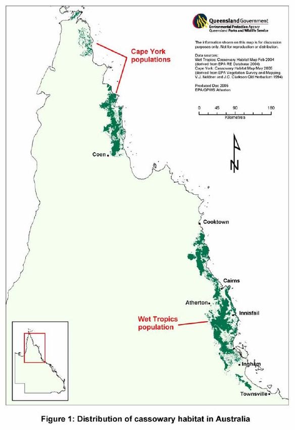
Title: Recovery plan for the southern cassowary Casuarius casuarius johnsonii

Prepared by: Peter Latch for the Cassowary Recovery Team

© The State of Queensland, Environmental Protection Agency, 2007

Copyright protects this publication. Except for purposes permitted by the Copyright Act,
reproduction by whatever means is prohibited without the prior written knowledge of the
Environmental Protection Agency. Inquiries should be addressed to PO Box 15155,
CITY EAST, QLD 4002.

Copies may be obtained from the:
Executive Director
Sustainable Communities
Environmental Protection Agency
PO Box 15155
CITY EAST QLD 4002

Disclaimer:
The Australian Government, in partnership with the Environmental Protection Agency,
facilitates the publication of recovery plans to detail the actions needed for the conservation
of threatened native wildlife.

This State approved recovery plan was prepared with financial support form the Australian
Government and has been adopted as a National Recovery Plan under the provisions of the
Commonwealth Environment Protection and Biodiversity Conservation Act 1999.

The attainment of objectives and the provision of funds may be subject to budgetary and
other constraints affecting the parties involved, and may also be constrained by the need to
address other conservation priorities. Approved recovery actions may be subject to
modification due to changes in knowledge and changes in conservation status.

Publication reference:
Latch, P. 2007. National recovery plan for the southern cassowary Casuarius casuarius
johnsonii . Report to Department of the Environment, Water, Heritage and the Arts,
Canberra. Environmental Protection Agency.

                                                                                                  2
Contents
Executive Summary................................................................................................................... 4
1. General information............................................................................................................... 5
Conservation status ......................................................................................................... 5
International obligations .................................................................................................. 5
Affected interests ............................................................................................................ 5
Consultation with Indigenous people .............................................................................. 5
Benefits to other species or communities ........................................................................ 5
Social and economic impacts........................................................................................... 6
2. Biological information ........................................................................................................... 6
Species description .......................................................................................................... 6
Life history and ecology ................................................................................................... 6
Distribution, abundance and population trends ................................................................ 7
Habitat critical to the survival of the species .................................................................... 7
Important populations....................................................................................................... 8
Figure 1: Distribution of cassowary habitat in Australia ................................................... 9
Figure 2: Distribution of cassowary habitat in the Wet Tropics ........................................ 10
3. Threats .................................................................................................................................... 11
Biology and ecology relevant to threats ........................................................................... 11
Identification of threats ..................................................................................................... 11
Areas and populations under threat ................................................................................. 14
4. Evaluation of previous recovery plan .................................................................................. 14
5. Recovery Objectives, Performance Criteria and Actions .................................................. 16
Overall objective............................................................................................................... 16
Specific objective 1: Protect essential cassowary habitat and landscape corridors......... 16
Specific objective 2: Institute a more coordinated and stronger planning response to
development issues in cassowary habitat........................................................................ 18
Specific objective 3: Implement strategies to protect cassowary populations by
minimising the adverse impacts of roads, dogs, pigs and cyclone events ....................... 19
Specific objective 4: Develop an effective cassowary rescue, rehabilitation and release
programme....................................................................................................................... 21
Specific objective 5: Cassowary populations are monitored to assess population size,
trends and status.............................................................................................................. 21
Specific objective 6: Improve understanding of cassowary ecology and threats to its
survival. ............................................................................................................................ 23
Specific objective 7: Engage the community in cassowary conservation and education . 24
Specific objective 8: Manage the recovery programme ................................................... 26
Summary table ................................................................................................................. 27
6. Management practices .......................................................................................................... 29
7. Evaluation of recovery plan .................................................................................................. 29
8. Costs of recovery................................................................................................................... 29
References.................................................................................................................................. 31
Appendix 1 Recovery team membership................................................................................. 34
Appendix 2 Regional Ecosystems designated as essential cassowary habitat .................. 35
Appendix 3 Habitat definitions used in cassowary mapping ................................................ 38
3Executive Summary
Species
The southern cassowary Casuarius casuarius johnsonii is a large flightless bird found in north
Queensland rainforests and associated vegetation mosaics.
Current species status
The southern cassowary is listed as ‘Endangered’ under the Commonwealth Environment
Protection and Biodiversity Conservation Act 1999. Under the Queensland Nature Conservation
Act 1992, the Wet Tropics population is listed as ‘Endangered’ and the Cape York populations are
listed as ‘Vulnerable’.
Habitat and distribution summary
Although occurring primarily in rainforest and associated vegetation, the cassowary also uses
woodland, swamp and disturbed habitats for a year-round supply of fleshy fruits. It occurs in three
broad populations. In the Wet Tropics it is distributed widely from Cooktown to just north of
Townsville. Core habitat is coastal lowlands between Ingham and Mossman, and uplands in the
southern Atherton Tablelands and other ranges. On Cape York, it occurs as two disjunct
populations in vine-forest communities: one in MacIlwraith and Iron Ranges, the other in Shelburne
Bay.
Threats summary
The Wet Tropics cassowary population is impacted upon by eight main threats. These same
threats are absent or of lesser significance for the Cape York population.
1. Habitat loss from clearing: more than 80 per cent of coastal lowland habitat has gone.
2. Habitat fragmentation: much of remaining habitat is fragmented, isolating groups and disrupting
movement.
3. Habitat degradation: through invasion of weeds such as pond apple, and changed fire regimes.
4. Roads and traffic: cassowaries are killed by vehicles on roads.
5. Dog attacks: urban development brings more domestic dogs.
6. Hand feeding: brings cassowaries closer to vehicle traffic and dogs.
7. Diseases: aspergillosis, avian tuberculosis and parasites.
8. Natural catastrophic events: cyclones.
Overall recovery objective
The overall objective of this recovery plan is to protect cassowaries, habitats and corridors from
threats through better planning, monitoring and community involvement.
Summary of recovery actions
The following recovery actions are required:
y complete the mapping of essential cassowary habitat and identify areas and corridors to
protect, restore and manage
y develop and implement Cassowary Conservation Local Area Plans as part of local planning
y minimise cassowary road deaths and dog attacks, and assess impact of pigs
y implement a translocation plan as part of rescue, rehabilitation and release
y establish a monitoring programme in key habitats
y develop and implement a population survey methodology based on faecal DNA
y study cassowary population at Mission Beach and determine genetic structure and
y involve community in cassowary conservation.
Evaluation and review
Members of the recovery team will review and evaluate progress annually. An independent
external examiner will review and evaluate performance of the recovery plan within five years of
the plan being adopted.
41. General information
Conservation status
The southern cassowary Casuarius casuarius johnsonii is listed as ‘Endangered’ under the
Commonwealth Environment Protection and Biodiversity Conservation Act 1999 (EPBC Act) and
under the Queensland Nature Conservation Act 1992 (NC Act) the Wet Tropics population is listed
as ‘Endangered’ and the Cape York populations are listed as ‘Vulnerable’.
International obligations
The southern cassowary is not listed under any international agreements. This recovery plan is
consistent with Australia’s international responsibilities.
Affected interests
Given their extensive distribution throughout the Wet Tropics and Cape York, cassowaries occur
on many land tenures. Cassowaries are of great conservation interest to the general community,
are of significant cultural importance to Aboriginal communities and of scientific interest to
researchers. Affected government authorities, organisations and individuals include:
• Environmental Protection Agency (EPA)
• Wet Tropics Management Authority
• Queensland Department of Natural Resources and Water
• Queensland Department of Primary Industries and Fisheries
• Queensland Department of Main Roads
• Local governments of Atherton, Cairns, Cardwell, Cook, Douglas, Dalrymple, Eacham,
Herberton, Hinchinbrook, Johnstone, Mareeba and Thuringowa
• Regional Natural Resource Management Bodies (NRM) – Terrain Queensland NRM (Far
North Queensland), Cape York Community Engagement Group
• Aboriginal communities, councils and representative bodies – Aboriginal Rainforest Council
and Girringun Aboriginal Corporation
• Land and Sea Management Centres on Cape York
• Local community conservation groups
• Conservation groups including the Cairns and Far North Environment Centre, Birds Australia
and Wildlife Preservation Society of Queensland
• Scientific research organisations including CSIRO and universities
• Private landholders
• Tourism bodies and local operators and
• Zoological institutions and associated industry organisations e.g. the Australasian Regional
Association of Zoological Parks and Aquaria (ARAZPA)
Consultation with Indigenous people
In the implementation of recovery actions, consideration will be given to the interests of Indigenous
people whose land the cassowary is found on, and involvement from these groups encouraged.
The plan allows for traditional owners to be represented through Aboriginal corporations, Land and
Sea Management Centres and communities. The Aboriginal Rainforest Council represents 17
Traditional Owner groups in the Wet Tropics and the Girringun Aboriginal Corporation represents
Traditional Owners at a sub-regional level in the southern part of the Wet Tropics Region. Both
helped develop the plan and are part of the recovery team.
Benefits to other species or communities
The cassowary is a major disperser of rainforest plant seeds and the only long distance disperser
of some species with large fleshy fruits. Because it is essential to forest ecology and habitats of
diverse species, the cassowary is a “keystone” species (i.e. one whose conservation is crucial to
other species and ecosystems).
In the Wet Tropics, 800,000ha of essential cassowary habitat includes 91 Regional Ecosystems of
which 15 are ‘Endangered’ and 23 ‘Of concern’ under the Vegetation Management Act 1999 (VM
Act) (Appendix 2). Its habitat includes more than 106 plant species and 37 animal species
5identified as threatened under State and Commonwealth legislation. Protection of cassowary
habitat will secure the habitat of many other species and ecological communities.
Social and economic impacts
The implementation of this recovery plan is unlikely to cause significant adverse social and
economic impacts. Issues surrounding protection and retention of habitat and any likely impact on
landholders have been considered in the development of the Wet Tropics Regional Vegetation
Management Codes for Broadscale Clearing and for Ongoing Clearing Purposes developed under
the VM Act. In addition, the use of economic and other incentives for retaining cassowary habitat is
subject to various actions within the plan.
Successful recovery efforts may have positive social, economic and educational impacts. The
cassowary is a flagship for Wet Tropics rainforest conservation. As this plan intends to raise the
profile of the cassowary, it may offer new economic opportunities and benefits to local
communities.
2. Biological information
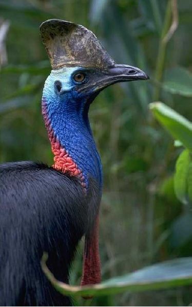
Species description
Cassowaries belong to the ratite group of large flightless land birds. Of the three species, only the
southern cassowary, Casuarius casuarius johnsonii, is found in Australia. It is the largest native
vertebrate in Australian rainforests. Adults grow to two metres tall with males up to 55kg and
females, usually larger, up to 76kg (Westcott and Reid 2002, QPWS unpub. data).
Newly hatched chicks are striped dark brown and creamy white. After three to six months the
stripes fade and the plumage changes to brown. As the young mature the plumage darkens, the
wattles and casque develop and the skin colour on the neck and wattles brighten.
Adults have shiny black plumage and a distinctive neck and head: brilliant blue and purple with
long, drooping red wattles and amber eye. The tall helmet or casque on maturing birds grows with
age. Each leg has three toes, with the inside toe bearing a large dagger-shaped claw. The sexes
are fairly similar though females are slightly larger. Cassowaries mature at about three years of
age.
Life history and ecology
Although occurring primarily in rainforest and associated vegetation mosaics, the cassowary also
uses woodland, swamp and disturbed habitats as intermittent food sources and as connecting
habitat between more suitable sites (Crome and Moore 1993; Bentrupperbäumer 1998). It requires
a high diversity of fruiting trees to provide a year-round supply of fleshy fruits. While some habitats
may be important only briefly in the annual cycle of food production, they may be crucial to the
survival of cassowaries whose home range encompasses them (Bentrupperbäumer 1998). Crome
and Moore (1990) suggest that at times of food stress in the rainforest, such as after cyclones,
food resources in non-rainforest habitats may be more important.
Their diet includes fleshy fruits of up to 238 plant species, including seven exotics (Westcott et al.
2005). While fallen fruit is the primary food source, cassowaries also eat small vertebrates,
invertebrates, fungi, plants and carrion (Marchant and Higgins 1990). They forage for about 35 per
cent of the day, mainly early morning and late afternoon (Westcott et al. 2005).
A large majority of seeds ingested by cassowaries retain their viability and are passed whole
(Stocker and Irvine 1983, Crome and Moore 1990, Bentrupperbäumer 1992). It has been
demonstrated that passage of some seeds through cassowaries can improve germination rates
(Webber and Woodrow 2004).
Cassowaries are one of only a few frugivores that can disperse large rainforest fruits and are the
only long distance dispersal vector for large seeded fruits (Crome and Moore 1988, 1990; Westcott
et al. 2005). It has been estimated that on average cassowaries move four per cent of seeds they
6consume more than 1km and an estimated average maximum distance of 1.473km (Westcott at al.
2005). These data indicate that cassowaries have the potential to provide significantly longer
dispersal on occasion, as much as 5.41km. The combination of long distance dispersal ability and
landscape scale movement means that cassowaries play a significant role in moving seeds
between populations and into new regenerating areas (Westcott et al. 2005). The loss of
cassowaries from part or all of their range results in relatively rapid changes in fruit dimensions and
population level dynamics, particularly for large-seeded species (Westcott et al. 2005).
The cassowary is territorial and solitary, with contact between mature individuals generally only
tolerated during mating. Sexes will maintain independent but overlapping home ranges with female
home ranges encompassing those of one to several males (Bentruperbäumer 1998). Home ranges
fluctuate depending on season and availability of fruit, with estimates of between 0.52km2 to
2.35km2 recorded (Bentrupperbäumer 1998; Moore and Moore 2001). Cassowaries may also
tolerate each other in areas of super abundant fallen fruit and have been known to congregate in
areas when artificially fed on a regular basis (QPWS unpublished).
Females lay three to five olive-green eggs, generally between June and October. Males incubate
the clutch for about 50 days before raising the young alone for about a year (Bentrupperbäumer
1998). Young birds must then seek their own home range, but with limited opportunities,
particularly due to high fragmentation and loss of habitat, the sub-adult mortality rate is probably
high.
Distribution, abundance and population trends
Cassowaries in the Wet Tropics were historically distributed between Cooktown in the north, south
to Townsville and west to the extent of rainforest including the entire rainforested portion of the
Atherton Tableland (Marchant and Higgins 1990). Present distribution remains similar but greatly
reduced and fragmented by forest clearance. Areas in which cassowaries are thought to be extinct
include large parts of the Atherton Tablelands, the lower Goldsborough Valley, the floor of the
Whyanbeel valley, the Clohesy River region and the Cassowary Range (Crome and Moore 1990).
The species has seldom been reported from around Cooktown, and near Townsville it only occurs
in low abundances in higher altitude areas of Bluewater and Mt Spec. Core habitat remains in the
rainforest and associated habitats of the coastal lowlands between Ingham and Mossman, and the
upland areas incorporating Seaview and Kirrama Range, the southern Atherton and Evelyn
Tablelands, the Lamb Range and the Carbine, Finnegan and Thornton uplands.
Cassowaries on Cape York Peninsula historically extended from just west of the tip of the Cape (at
the mouth of the Jardine River) and down the east coast to at least as far south as Massey River
(Thomson 1935) and probably further south into the Princess Charlotte Bay area (QPWS 2003).
Cassowaries are known today from all historical sites with the exception of those in the far north.
Cassowaries are suspected to have disappeared from the Lockerbie Scrub near Bamaga, as there
have been no sightings since 1986 (QPWS 2003). Cassowaries on Cape York occur as two
disjunct populations: a southern population centred on the vine forests of the MacIlwraith and Iron
Ranges and a northern population centred on the much less extensive vine forests north of
Shelburne Bay (Appendix 4: Figure 1). Vine-forests are very poorly developed south of the
Princess Charlotte Bay area (Neldner and Clarkson 1995) and it is likely that the Cape York
cassowary populations have been disjunct from the Wet Tropics population since well before the
arrival of Europeans.
In 1988 the Wet Tropics population was estimated at between 2500–4000 adults (Crome and
Moore 1990), by 2001 it was estimated at less than 1500 (Moore and Moore 2001). These
estimates have been based on extrapolated survey data from several focal area studies (Moore
and Moore 1999a, c, d, f; Moore and Moore 2001) but there are no detailed descriptions of the
process used to arrive at Wet Tropics-wide estimates.
Habitat critical to the survival of the species
As a significant amount of cassowary habitat has been lost through clearing, all remaining habitat
utilised by cassowaries is considered important. Three categories of habitat utilised by cassowaries
7have been identified and mapped in the Wet Tropics by EPA (see Appendix 4: Figure 2) and are
based on the Regional Ecosystem (RE) mapping. While three categories have been defined (see
Appendix 3) it is the category of ‘essential habitat’, defined as being necessary for the persistence
of cassowary populations in perpetuity, that is deemed to be the best estimate of habitat critical to
the survival of the species. Essential cassowary habitat has been afforded protection under the VM
Act and is the priority target for protection in this plan.
More than 800,000ha of essential cassowary habitat has been mapped in the Wet Tropics of which
84 per cent falls within the Wet Tropics World Heritage Area (WHA). While the majority of habitat
lies within protected tenures (including both the WHA and the EPA estate) 11 per cent exists
outside these areas, primarily on freehold land. In all, 91 RE types comprise essential habitat, the
majority of which are rainforest.
Preliminary mapping of cassowary habitat on Cape York has been undertaken (QPWS 2003) but
this is subject to further analysis and adoption of the method used in the Wet Tropics mapping. On
Cape York, 98 per cent of all cassowary records that could be confidently associated with a habitat
type were from seven vine forest types (after Neldner and Clarkson 1995). The majority of records
are from mesophyll forest types (43 per cent) and notophyll vine-forest (24 per cent). The extent of
vine forest on Cape York in which cassowaries have been recorded is 488,547ha (QPWS 2003).
Important populations
Crome and Moore (1990) identified areas of high cassowary activity or ‘hotspots’ around Mission
Beach, Coquette Point (Moresby Range), Graham Range, Woopen/Badgery Creeks (upper
Russell and North Johnstone River valleys), and the Wallaman Falls/Mt Fox areas. They further
suggested that the Black Mountain corridor (Macalister Range), the Lamb Range to Davies Creek
and the slopes on the north and east shores of Lake Tinaroo, appeared to be important for
cassowary populations. Six priority Regional Cassowary Management Areas are identified as
having extreme current/potential threats to their cassowary populations (see Moore and Moore
1999a, c, d, e, f). They are the Daintree lowlands, Kuranda and Black Mountain Road, sections of
the Cairns foothills, Innisfail, Mission Beach and Paluma/Mt Spec.
Given their spatial and probable long-term temporal isolation from one another, the Wet Tropics
and Cape York populations might well represent distinct genetic populations, but no population
genetics data exists to confirm this. There appear to be at least ten subpopulations that have
become isolated by clearing in the Wet Tropics (Garnett and Crowley 2000; QPWS 2002).
89
10
3. Threat0.s
Biology and ecology relevant to threats
It is difficult to assess the impact of threats to cassowaries when comparatively little is known of
their ecology and behaviour, as well as use of fragmented habitats, immigration and birth rates.
The extent and pattern of cassowary movement and remnant use is probably dependent on
broader landscape patterns such as size of remnants available and the landscape context, type of
vegetation in the remnant, proximity of other remnants and intact habitat, presence of other birds,
food sources and fruiting phenology.

For small isolated populations there may be no substantial recruitment of new individuals due to
available habitat occupied by adults and increased mortality of chicks and juveniles caused by
dogs and cars. A lack of area suitable for juveniles to forage away from resident adults will also
increase pressures on available resources, reducing the capacity of the local population to
withstand cycles of environmental stress, for example, periods of low fruiting. The genetic health of
isolated populations may be compromised by the effects of genetic drift and the loss of viability due
to inbreeding depression.

Cassowaries are solitary, long-lived, slow-reproducing animals with lengthy parental care and
probable low natural juvenile survival. The slow recruitment rate of cassowaries makes it difficult to
determine the long-term viability of isolated populations. The persistence of individuals in patches
of remnant habitat may not necessarily mean that the population is viable and will persist
long-term.

Management responses such as the selective re-introduction of captive reared cassowaries is
likely to be problematic, given that potential ‘unoccupied’ sites are unlikely to support any new birds
reintroduced there. Therefore captive breeding for larger scale recovery release purposes is
unlikely to be viable.

Identification of threats
Known and potential threats to cassowaries in the Wet Tropics area are well documented (Crome
and Moore 1990; Garnett and Crowley 2000; QPWS 2002). Many threats are localised and don’t
operate across the extent of cassowary distribution. For example, road mortality tends to be a
major issue in those areas where substantial urban/peri-urban development encroaches into
cassowary habitat. Some threats target particular age groups; subadults and chicks, for example,
are the most vulnerable to dog attack. Other factors such as habitat fragmentation may cause
birds, particularly dispersing subadults, to travel further to access food and new habitat therefore
increasing the risk of road mortality for that age class.

Little is known about the status of the Cape York population. Habitat is largely intact and not
threatened by clearing and mortality from vehicle strikes or domestic dogs is unknown. Hunting
may have contributed to the decline of cassowaries in the Lockerbie Scrub area, but it is not
considered to be a threat at present (QPWS 2003). More information is required to determine the
status of, and threats to, the Cape York population.

Habitat loss
The major threat to the long-term survival of Wet Tropics cassowaries is clearing and
fragmentation of habitat. Vegetation loss is most extensive in the lowlands. By 1983, 57 per cent of
lowland rainforest had been cleared with most of the rest highly fragmented (Winter et al. 1987). By
1997, 81 per cent of native vegetation had gone. In the past decade, clearing rates have slowed
from 3000ha to 1000ha a year but are relatively constant (DNRM 2005).

While Wet Tropics Vegetation Management Codes regulate clearing, housing development still
threatens local populations as supporting habitat is cleared. In Mission Beach incremental losses
to severely fragmented habitat may eventually destroy the viability of the local population. Even low
density housing brings more traffic and dogs. As small incremental habitat loss is a major threat, it
warrants more attention in the planning process.

                                                                                                    11
Habitat fragmentation
Habitat fragmentation resulting from clearing disrupts movement paths, may segregate feeding and
breeding sections of an individual’s range, and could lead to genetic isolation and local extinctions.
The presence of a cassowary in an isolated forest patch does not indicate a secure local
population. Cassowaries may persist but no longer breed or sub-adults might not survive. Crome
and Moore (1988, 1990) have documented disappearance or severe decline in several forest
patches. This process is evident on coastal lowlands, such as Moresby Range (Moore 1999d) and
Mission Beach (Moore and Moore 2001).
Habitat degradation
Selective logging, weed invasion and disturbance to rainforest by changed fire regimes are all
considered factors that degrade habitat quality for cassowaries, by decreasing shelter and
degrading breeding sites and food sources. Crome and Moore (1988) suggest that cassowaries
can tolerate some structural damage to their habitat and that an intermediate level of damage,
particularly that which promotes high species diversity, may favour them. Severe fires can
progressively destroy rainforest on steep slopes, however the maintenance of sclerophyll
communities utilised by cassowaries is dependant on the presence of fire.
Pond apple, Annona glabra, one of the most threatening environmental weeds of the Wet Tropics
(Werren 2001) has invaded a wide range of cassowary habitat. It is a semi-deciduous woody tree
that forms dense thickets. Where pond apple dominates a community it replaces a diverse annual
cycle of fruits with a single species, rendering the area unsuitable for cassowary foraging for all but
the pond apple fruiting season. As the pond apple fruit is an attractive food source for cassowaries,
they aid in its dispersal thus exacerbating its spread (Setter et al. 2002). When cassowaries feed
on pond apple along main roads the risk of vehicular strike is significantly increased (A&RMCANZ
2001).
Roads and traffic
Some 3777km of highways, roads and tracks criss-cross the Wet Tropics World Heritage Area
(WTMA 2004). Roads fragment habitat, create barriers to cassowary movement, produce edge
effects, introduce exotic species and cause substantial mortality through direct strikes. Roads are
also precursors to future impacts, because they often facilitate land development and the further
expansion of the road network itself. Crome and Moore (1993) found that the home ranges of
approximately half of the cassowaries in the Daintree lowlands are intersected by roads. Most
other significant cassowary population areas such as Mission Beach are also either fragmented or
surrounded by roads.
Because of its fragmented distribution, road mortality is likely to have highly significant impacts on
the cassowary population. During 2001–05 28 cassowaries or 76 per cent of the total cassowary
deaths recorded at Mission Beach were killed on roads (QPWS unpublished data). Given that
cassowaries are long-lived, slow-reproducing animals with lengthy parental care and low juvenile
survival, each road death of an adult bird may potentially influence population dynamics and the
population’s reproductive fitness (Bentrupperbäumer 1998).
Dogs
Dog attacks on cassowaries are known to cause injury and death and their presence potentially
affects cassowary feeding, movements and behaviour (Crome and Moore 1988; Crome and Moore
1990). After vehicle strikes, dog attack may be the second most important recorded source of
cassowary mortality (Bentrupperbäumer 1998; QPWS unpublished data). Of the six recorded
cassowary deaths attributed to dog attack at Mission Beach between 1992–2005, five were
subadults or chicks. Mortality in these age groups could be a significant impediment to recruitment
in cassowary populations.
It is difficult to quantify the threat dogs pose. Actual deaths could be higher as attacks may go
undetected or unreported. Without controls on roaming and adequate education on responsible pet
ownership, the potential impact of dogs may be substantial in and near residential areas.
12Pigs
Feral pigs are a major Wet Tropics pest and significant threat to World Heritage values (WTMA
2004). However, there is no evidence that feral pigs adversely affect cassowary survival (McIlroy
2001; DEH 2005). They reportedly destroy nests and eat cassowary eggs (Crome and Moore
1988; Crome and Moore 1990; Mitchell 1993; Mitchell 2000) but the significance is unknown.
Cassowaries raise chicks every year in Wet Tropics areas with large pig populations (e.g. Jarra
Creek and Cowley beach), predation on eggs or chicks may have little impact on populations
(S. Burnett unpub. data).
Pigs may compete for food but how much they eat or disperse seed is unclear. Pigs degrade
habitat and water quality by wallowing and rooting around watercourses and swamps. As
cassowaries depend on fresh water for daily drinking and bathing (Bentrupperbäumer 1998),
changes in water availability and quality could threaten populations.
Human Interaction
Hand-feeding of cassowaries is a risk to both birds and humans, and despite being illegal
(Queensland Nature Conservation Regulation 2006), people still feed them. Wild cassowaries
conditioned to human food sources can be aggressive when protecting or seeking other human
food. Regularly fed birds may then become a hazard. Of 150 recorded incidents (Kofron 1999) of
cassowary attacks on humans, 75 per cent were known or suspected as being feeding-related.
As birds become less wary of humans, they may become more vulnerable to dog attack and road
mortality as they move around looking for food. Hand-feeding at roadsides by people results in
cassowaries being attracted to roads and consequently hit by traffic. Birds have also been
observed to congregate in areas when artificially fed on a regular basis (QPWS unpublished); the
impact this has on the ecology and social dynamics of the population is not known.
Disease
The possibility of avian diseases in cassowaries is serious given worldwide evidence that wildlife
diseases pose a growing threat in conservation biology (Daszek et al. 2000; Daszak et al. 2001). It
may become a management issue particularly for local populations under stress (Crome and
Moore 1990). Known diseases include internal parasites (particularly ascarids), aspergillosis,
Aspergillus fumigatus, and avian tuberculosis (TB), Mycobacterium avium. Immature birds (8–12
months) could be most affected (Dr Annabelle Olsson pers. comm).
Avian TB is a ubiquitous disease with the organism found in the environment including soil and
water. A chronic wasting disease, it has been diagnosed post mortem with six recent cases (2002–
05) in Mission Beach and Atherton Tablelands areas (QPWS unpublished data). Aspergillosis, the
most common mycotic infection of the respiratory tract in birds is possibly a secondary disease of
debilitated cassowaries causing respiratory symptoms and ultimately mortality (Romer 1997).
Because aspergillosis is an opportunistic infection, stress and malnutrition may contribute to
immunosuppression and increased susceptibility to the disease (Oglessbee et al. 1997).
Natural catastrophic events
Tropical cyclones are an integral part of the natural history of north Queensland (Webb 1958;
Unwin et al. 1988). Webb (1958) estimated that none of the rainforests of the lowlands and foothills
of north Queensland could escape severe or general cyclone damage for more than 40 years. Two
severe cyclones since the mid 1980s have caused considerable and widespread disturbance to
cassowary habitat; Cyclone Winifred in 1986 and Cyclone Larry in 2006. Extensive disturbance to
coastal lowland habitat by Winifred is documented (Unwin et al. 1988) while preliminary
assessment of Cyclone Larry impacts indicates considerable damage to forest structure far greater
and more widespread than that of Winifred (QPWS unpub.data). Although vegetative recovery of
forests appears rapid and widespread following cyclones (Unwin et al. 1988; Applegate and Bragg
1992), fires and weed invasion in disturbed areas potentially places habitat at further risk of
degradation. There is little empirical evidence of the impact of cyclones on cassowary populations
but observations of structural damage to habitat suggest the impact could be considerable.
Cyclonic events will continue to adversely affect cassowary populations. Particularly small and
13fragmented populations that are vulnerable to threats posed by development, isolation and other
pressures.
Areas and populations under threat
Eight key Wet Tropics areas identified in the Cassowary Recovery Plan 2001–05 (QPWS 2002)
are still seriously threatened by development pressures. Populations in these areas are therefore
considered to be under the greatest threat.
• Mission Beach
• Daintree/Mossman lowlands
• Kuranda/Black Mountain corridor
• Cairns hill slopes
• Mulgrave Valley/Malbon-Thompson Range
• southern Atherton Tablelands
• Graham/Palmerston/Moresby Range
• Kennedy Valley/Murray River floodplain
The Cape York populations are considered to be under less threat than the Wet Tropics population
(QPWS 2003) but a more detailed assessment is needed.
4. Evaluation of previous recovery plan
This recovery plan is a revision of the Recovery plan for the southern cassowary Casuarius
casuarius johnsonii 2001–05. The overall objective of the previous recovery plan was to secure
and enhance the status of the cassowary through an integrated programme of investigations, on
ground management, public awareness raising and capacity building during the life of the plan.
The following is an overview of the outcomes of the previous actions.
Action 1.1: Identify priority areas for protection
This action was implemented by developing a Wet Tropics cassowary habitat map. This map is
being used by state and local government in assessing development applications. The 11 per cent
of cassowary habitat currently falling outside protected and world heritage areas (mainly on
freehold land) now receives priority conservation action.
Action 1.2: Restore linkages to reverse the problems of habitat fragmentation
Linkages and corridors were identified as part of the planning process for the Wet Tropics
Conservation Strategy and through the habitat mapping process. These linkages are informing
community driven restoration projects. Australian Rainforest Foundation is funding development of
a detailed corridors plan for Mission Beach. At a local government level work has commenced on
identifying key core habitat areas and linkages and developing strategies to rehabilitate and protect
them. Much community restoration work on cassowary corridors has been completed through the
Australian Government-funded projects in the coastal lowlands and on the Atherton Tablelands.
Action 1.3: Incentives to protect cassowary habitat on private lands
More cassowary habitat has been protected under the Nature Refuge programme, which provides
landholders with support and opportunities to obtain funding for management of their properties.
Action 1.4: Memorandum of Understanding between State Government departments
State government agencies have been actively involved in the recovery of the cassowary. The
Queensland Department of Main Roads (QDMR) has erected extensive signage, reduced speed
limits and implemented traffic calming. QDMR, with support from EPA, is also funding the
monitoring of a trial cassowary-crossing culvert at Mission Beach. The Queensland Department of
Natural Resources and Water (DNRW) has also been involved in cassowary recovery through feral
pig control programmes.
14Action 2.1: Management of road mortality
In response to cassowary road mortality issues at Mission Beach, the QDMR erected extensive
signage, reduced speed limits and implemented traffic calming. The Cassowary Management
Strategy for Tully–Mission Beach Road is seen as a model for future road management work.
QDMR, with support from EPA, is also funding the monitoring of a trial cassowary-crossing culvert
at Mission Beach. Identification and monitoring of cassowary crossing points and cassowary ‘black
spots’ is being undertaken by EPA. All road strikes, injuries and deaths reported to EPA are
entered into a database.
Action 2.2: Dog control
Various community organisations and local councils have promoted information identifying the
detrimental affect of dogs attacking or disturbing cassowaries. Local residents have been
encouraged to control roaming dogs by EPA through the ‘Be Cass-O-Wary’ programme and by
other organisations.
Action 2.3: Pig control
Feral pig control programmes continue to be implemented by DNRW.
Action 2.4: Cassowary rescue programme
EPA continues to manage a successful cassowary rescue, rehabilitation and release programme
with rehabilitation facilities at Mission Beach and Hartley’s Creek Crocodile Farm. EPA has the
lead role in responding to cassowary incidents. Procedures are in place to respond to any sick,
injured or killed cassowary. Comprehensive training for staff has been provided in all aspects of
cassowary emergency response, handling and transport procedures. Translocation of successfully
rehabilitated sick or injured birds continues and problem birds have also been successfully
translocated.
Action 3.1: Cassowary population monitoring
Effective population monitoring has been constrained by lack of population monitoring techniques.
EPA and CSIRO have begun the development of a faecal DNA identification technique and this
technique will be progressed in this plan. The use of camera traps as a remote survey and
monitoring technique has been extensively trialed in the Wet Tropics and Cape York. This
technique proved problematic and was not pursued. The technique relied on taking high quality,
profile photos of the cassowaries for accurate identification, however it was difficult to consistently
obtain such images.
Information relating to cassowary sightings and incidents continue to be maintained by EPA in a
GIS-based database. This database informs management decisions such as habitat distribution
mapping, development assessment and other planning matters. The database records data on
sightings and on sick, injured or dead cassowaries as well as post mortem results and
cassowary/human incidents.
Action 3.2: Education, communication and community action
Through the efforts of the Cassowary Advisory Group, EPA and WTMA cassowary recovery
receives comprehensive publicity via the print, electronic and broadcast media. In response to
incidents involving cassowary/human interactions and the need for a more consistent and
overarching framework for the delivery of cassowary conservation messages generally EPA has
developed a cassowary education strategy. Through the theme ‘Be Cass-O-Wary’ the message of
‘never feed cassowaries’ is actively promoted. Brochures and posters have been produced and
disseminated through local communities. Television Community service announcements supported
by WTMA and the CAG outlining the no feeding message have been broadcast. Temporary
signage about the issues of feeding and the consequences for doing so have been placed in areas
where feeding is suspected.
A cassowary education kit has been developed by WTMA and the Cassowary Advisory Group and
has been distributed through schools in the Wet Tropics.
15Interpretation material has also been produced and is displayed by ARAZPA member zoos and
wildlife parks to promote cassowary conservation.
Action 3.3: Indigenous community involvement
Aboriginal communities in the Wet Tropics and Cape York have been engaged in recovery actions.
‘Cassowary and Culture’ posters have been developed, distributed and promoted through Cape
York Aboriginal communities. Girringun Aboriginal Corporation has developed a short educational
film/documentary about the cassowary including aspects of its cultural significance to the rainforest
Aboriginal people as well as scientific information about the cassowary.
Action 3.4: Recovery coordination
This recovery plan has been effectively coordinated to achieve the objectives set.
Action 4.1: Population assessment techniques
The use of camera traps as a remote survey and monitoring technique was extensively trialed in
the Wet Tropics and Cape York. This technique proved problematic and was not pursued.
Action 4.2: Population trends and effects of different threats
Information on cassowary sightings and incidents continue to be maintained by EPA in a GIS-
based database. An honours project has been developed to investigate the mortality of sub-adults
at Mission Beach. The ecological significance of the cassowary as a disperser of seeds in the
landscape is the subject of a major CRC Rainforest project (CSIRO/EPA). Results are currently
being prepared for publication with one significant paper published (Westcott et al. 2005).
Research will continue to inform future recovery actions.
5. Recovery objectives, Performance Criteria and Actions
Overall objective:
To secure the long-term protection of cassowary populations through improved planning
mechanisms supported by robust monitoring, threat abatement and community
engagement programmes.
Specific objective 1: Protect essential cassowary habitat and landscape corridors
Action 1.1 Complete mapping of essential cassowary habitat
Performance criterion 1.1 Cassowary map updated for the Wet Tropics and Cape York populations
Essential cassowary habitat in the Wet Tropics has been mapped and is based on the Queensland
Herbarium Wet Tropics Interim Regional Ecosystem (RE) 1:100,000 mapping Version 4. With the
release of Version 5 of the Wet Tropics RE mapping, a priority action is to update the cassowary
map in line with this new RE coverage. Preliminary mapping of Cape York cassowary habitat
(QPWS 2003) is subject to further analysis and adoption of the Wet Tropics mapping methodology
(see Kutt et al. 2004).
Potential contributors: EPA, WTMA, CYNRM, Terrain NRM
Action 1.2 Identify and prioritise areas of essential habitat for protection and management
Performance criterion 1.2 Essential habitat areas assessed and assigned a priority ranking
EPA mapping identifies essential cassowary habitat but not local or regional areas targeted for
cassowary conservation. The map serves as a baseline for more detailed plans. Once Action 1.1 is
complete, priority conservation areas will be identified and appropriate conservation
recommended. Data to be considered includes fragmentation and other threats, cassowary
ecology, and planning issues such as land tenure, development pressures and regional ecosystem
conservation status.
16Assessment will build upon completed work (e.g. Moore and Moore 1999a,c,d,e,f). Assessment
criteria will be developed to ensure that a consistent and defensible approach is taken to priority
ranking. The priority assessment process will be based on GIS and field-derived data. This action
will underpin development of Local Area Cassowary Conservation Plans (see Actions 2.2 and 2.3)
or other possible planning instruments.
Potential contributors: EPA, WTMA, Terrain NRM, ARF, local councils, CAG, community groups
Action 1.3 Identify and prioritise habitat corridors for protection, restoration and
management
Performance criterion 1.3 Priority habitat corridors identified, mapped and assigned a conservation
priority ranking
To link isolated cassowary populations, a network of corridors needs to be established. Local
governments have started identifying core habitat areas and links, and rehabilitation and protection
strategies. With Australian Government funding, communities have restored many corridors in
coastal lowlands and the Atherton Tablelands.
Broad landscape links identified under Wet Tropics Regional Vegetation Management Codes and
in the Wet Tropic Conservation Strategy (WTMA 2004) form the basis for the 25 landscape
corridors in this plan. These corridors are north/south, and broadly east/west between coastal
habitats and footslopes and ranges (Appendix 4: Figure 2). Detailed macro-scale corridor plans are
needed to identify specific areas for protection, restoration and management. Combined with
Action 1.2, these plans will help develop Cassowary Conservation Local Area Plans. A monitoring
programme will be established to assess effectiveness of corridors (Action 5.4). Information from
appropriate genetic analysis (Action 6.2) may be informative about population connectivity afforded
by existing and planned corridors.
Potential contributors: EPA, DNRW, ARF, Terrain NRM, CYNRM WTMA, CSIRO, ARF, local
councils, community groups,
Action 1.4 Investigate strategies to conserve cassowary habitat on private lands
Performance criterion 1.4 Conservation measures for private land identified and additional areas of
cassowary habitat are protected and being managed by landholders
Recovery will be more effective if habitat and connecting habitat on private lands, particularly
coastal lowlands, are also managed for conservation. Building on Actions 1.2 and 1.3 and
Cassowary Conservation Local Area Plans, this action will investigate the adoption of appropriate
strategies and conservation incentives to involve landholders in the management of cassowaries
on their land. Non-regulatory financial incentives include grants, rate deferrals and rebates,
conservation or management agreements, covenants, revolving funds and development benefits.
A number of initiatives are underway. The Australian Rainforest Foundation is developing different
ways to assist landholders in cassowary conservation through the acquisition, covenanting and
on-selling of cassowary habitat. EPA is negotiating nature refuges on properties supporting
cassowary habitat. Several Wet Tropics shire councils have a rate deferral incentive scheme to
encourage voluntary habitat retention. Terrain NRM has plans to research and implement financial
incentives under the Wet Tropics NRM Plan.
Substantial liaison will be sought with the community to canvass opinion regarding incentives for
the protection and management of significant habitat. Local authorities will be involved in
documenting the best ways to maximise cassowary habitat protection through local planning
schemes. These outcomes will indicate the level of funding required to achieve effective habitat
conservation on private lands.
Potential contributors: EPA, CY Land and Sea Centres, CYNRM, Terrain NRM
Specific objective 2: Institute a more coordinated and stronger planning response to
development issues in cassowary habitat
17Action 2.1 Strengthen linkages with other planning mechanisms to ensure an integrated
and more consistent approach to cassowary conservation
Performance criterion 2.1 Review of effectiveness of current planning instruments completed with
recommendations implemented
A number of local, regional, state and national strategic NRM plans complement, support and/or
guide development and implementation of cassowary recovery actions. These include:
• FNQ Regional Plan
• Wet Tropics NRM Plan
• Local government planning schemes
• Regional Coastal Management Plans
• Wet Tropics Conservation Strategy
• Wet Tropics Aboriginal Cultural and Natural Resource Management Plan and
• Draft Mahogany Glider Recovery Plan and the draft Mabi Forest Recovery Plan.
This action aims to better integrate cassowary recovery with natural resource planning and
investment at the regional and local levels through improved consultation with stakeholders and
promotion of the recovery plan as the major strategic document directing cassowary conservation
effort. The recovery team will engage all planning bodies to develop a consistent approach to
cassowary conservation. This process will also examine opportunities for sharing resources and for
submitting shared competitive funding bids as opportunities arise.
This action will audit cassowary protection within local government planning and help develop
better planning scheme mechanisms to protect cassowary habitat. The outcome will complement
development of Cassowary Conservation Local Area Plans and Action 2.3.
Potential contributors: EPA, Terrain NRM, WTMA, local councils
Action 2.2 Develop and implement Cassowary Conservation Local Area Plans
Performance criterion 2.2 Three Cassowary Conservation Local Area Plans developed, endorsed
by recovery team and implemented
This action provides a mechanism to build upon the outcomes of Actions 1.2, 1.3 and 1.4 to
implement on-ground protection and conservation actions through a coordinated Cassowary
Conservation Local Area Plan. These plans will be non statutory and rely on partnership
arrangements between stakeholders. These plans will also build upon earlier regional cassowary
management plans (e.g. see Moore and Moore 1999a, 1999c, 1999d)
The planning process will ensure all stakeholders are involved and that local issues are addressed
within the context of broader cassowary conservation priorities. The local community will retain
ownership of the plan. A local planning group should be formed for each area, comprising
representatives from state and local government, community conservation groups, private
landholders, Aboriginal groups and industry.
Plans will prioritise actions, assign costs and identify potential participants and funding sources. In
the life of this plan it is envisaged that at least three plans be developed and implemented on a
priority basis. A Mission Beach Local Area Plan is to be developed as a priority. Other plans will be
developed and will be identified through Action 1.2.
Potential contributors: Terrain NRM, EPA, WTMA, ARF, local councils, community and
conservation groups, Aboriginal groups, industry
Action 2.3 Investigate development of other statutory planning instruments to minimise
impacts of development on cassowaries
Performance criterion 2.3 Report prepared outlining options for development of statutory planning
instruments to minimise impacts of development on cassowaries
It is the preferred intent of this recovery plan to develop non-statutory mechanisms to protect and
manage cassowary habitat and reduce threats through a consultative local planning process
18(Actions 2.1 and 2.2). However in response to ongoing development pressures on habitat in some
of the more urbanised areas the development of a new appropriate statutory planning instrument
may also be required to ensure development is compatible with cassowary conservation.
One such instrument could be a State Planning Policy (SPP). Developed under the Integrated
Planning Act 1997 a SPP could provide a high level of direction and support to government and
others called on to make planning decisions on development relevant to cassowary conservation.
The anticipated outcome of a SPP would be to ensure that future development in cassowary
habitat is compatible with conservation of the species. It may also provide protection measures to
address issues arising from new developments including incremental habitat loss, the impacts of
roads, dog control and the provision and protection of habitat links.
Potential contributors: EPA, WTMA, Department of Local Government, Planning, Sport and
Recreation (DLGPSR), local councils, community groups
Specific objective 3: Implement strategies to protect cassowary populations by
minimising the adverse impacts of roads, dogs, pigs and cyclone events
Action 3.1 Minimise cassowary road mortality and injury
Performance criterion 3.1 Strategies to minimise cassowary road mortality incorporated into road
planning and construction and a monitoring programme established to evaluate cassowary road
management strategies
Strategies for reducing road deaths at Mission Beach, Daintree and Kuranda were identified by
Moore and Moore 1999 a,b,c, 2001. Based on this work, the Department of Main Roads (DMR)
erected signs, cut speed limits and calmed traffic at Mission Beach as part of the Cassowary
Management Strategy for Tully–Mission Beach Road (DMR 2001). This approach could be used
as a model in planning, building, maintenance, upgrading – and public education. While many
proposed DMR strategies such as under road crossing structures need more research, priority
work will continue at all identified areas.
Driver behaviour, vehicle strike frequencies, cassowary crossing points and ‘black spots’ should be
monitored. All strikes, injuries and deaths should be reported to EPA and entered into a database,
with road-strike data analysed for population viability models. Where possible, monitoring will be
integrated into Local Area Cassowary Conservation Plans.
Potential contributors: EPA, WTMA, Terrain NRM, DMR, local councils
Action 3.2 Implement appropriate dog control to minimise dog attacks on cassowaries
Performance criterion 3.2 Responsible dog ownership education programme developed and
promoted in the community with support from local councils
Shire councils will be encouraged to adopt and enforce dog registration, control regulations and
incentives to minimise the incidence of roaming dogs. Regulatory mechanisms and financial
inducements will be investigated and appropriate methods will be provided and promoted to all
shires throughout cassowary habitat. A responsible dog-ownership education programme will also
be developed and promoted through community education. Educational material will be developed
and public promotional campaigns initiated. Appropriate pig-trapping programmes will be
encouraged to try to phase out pig hunting using dogs in cassowary habitat. An educational
pamphlet will be produced for local shire councils.
Potential contributors: EPA, WTMA, Terrain NRM, CYNRM, councils, conservation groups.
Action 3.3 Assess potential impacts of pigs on cassowaries
Performance criterion 3.3 Impacts of pigs on cassowaries assessed
As recommended in the Australian Government’s Threat Abatement Plan for Pigs (DEH 2005) this
action aims to quantify the impact of feral pigs on cassowaries and to determine the relationship
between feral pig density and the level of damage. This action will:
19You can also read