REDEFINING THE UPPER JURASSIC MORRISON FORMATION IN THE GARDEN PARK NATIONAL NATURAL LANDMARK AND VICINITY, EASTERN COLORADO
←
→
Page content transcription
If your browser does not render page correctly, please read the page content below
GEOLOGY OF THE INTERMOUNTAIN WEST
                                                                             an open-access journal of the Utah Geological Association
                                                                                                                     ISSN 2380-7601
                       Volume 6                                                                                                  2019

 REDEFINING THE UPPER JURASSIC MORRISON FORMATION IN THE GARDEN
 PARK NATIONAL NATURAL LANDMARK AND VICINITY, EASTERN COLORADO
                                                Kenneth Carpenter and Eugene Lindsey

                                                 Theme Issue
                                     An Ecosystem We Thought We Knew—
                               The Emerging Complexities of the Morrison Formation
                                 SOCIETY OF VERTEBRATE PALEONTOLOGY
                                                   Annual Meeting, October 26 – 29, 2016
                                                          Grand America Hotel
                                                        Salt Lake City, Utah, USA

© 2019 Utah Geological Association. All rights reserved.
For permission to copy and distribute, see the following page or visit the UGA website at www.utahgeology.org for information.
Email inquiries to GIW@utahgeology.org.
GEOLOGY OF THE INTERMOUNTAIN WEST
                                                                               an open-access journal of the Utah Geological Association
                                                                                                                       ISSN 2380-7601

                         Volume 6                                                                                                                       2019

                        Editors                                                                              UGA Board
   Douglas A. Sprinkel            Thomas C. Chidsey, Jr.                                      October 2018 – September 2019
  Utah Geological Survey          Utah Geological Survey              President           Peter Nielsen            peternielsen@utah.gov            801.537.3359
       801.391.1977                    801.537.3364                   President-Elect     Leslie Heppler           lheppler@utah.gov                801.538.5257
  GIW@utahgeology.org             tomchidsey@utah.gov                 Program Chair       Gregory Schlenker        gcsgeoscience@gmail.com          801.745.0262
                                                                      Treasurer           Dave Garbrecht           garbrechtd@yahoo.com             801.916.1911
     Bart J. Kowallis                 Steven Schamel                  Secretary           George Condrat           gcondrat@loughlinwater.com       435.649.4005
                                                                      Past President      Paul Inkenbrandt         paulinkenbrandt@utah.gov         801.537.3361
Brigham Young University           GeoX Consulting, Inc.
      801.422.2467                     801.583-1146
  bkowallis@gmail.com              geox-slc@comcast.net                                               UGA Committees
                                                                      Environmental Affairs    Craig Eaton           eaton@ihi-env.com              801.633.9396
                                                                      Geologic Road Sign       Terry Massoth         twmassoth@hotmail.com          801.541.6258
                                                                      Historian                Paul Anderson         paul@pbageo.com                801.364.6613
                                                                      Outreach                 Greg Nielson          gnielson@weber.edu             801.626.6394
                                                                      Membership               Rick Ford             rford@weber.edu                801.626.6942
                                                                      Public Education         Paul Jewell           pwjewell@mines.utah.edu        801.581.6636
                                                                                               Matt Affolter         gfl247@yahoo.com
                                                                      Publications             Paul Inkenbrandt      paulinkenbrandt@utah.gov       801.537.3361
                                                                      Publicity                Paul Inkenbrandt      paulinkenbrandt@utah.gov       801.537.3361
 Society of Vertebrate Paleontology                                   Social/Recreation        Roger Bon             rogerbon@xmission.com          801.942.0533

               Editors
       Kelli C. Trujillo — University of Wyoming                                               AAPG House of Delegates
   John Foster — Utah Field House of Natural History                  2017–2020 Term           Tom Chidsey           tomchidsey@utah.gov            801.537.3364
                   State Park Museum
        Cary Woodruff — University of Toronto
     Octavio Mateus — Universidade Nova de Lisboa
                                                                                        State Mapping Advisory Committe
                                                                      UGA Representative       Jason Blake           blake-j@comcast.net            435.658.3423

                   Production
       Cover Design and Desktop Publishing                                                  Earthquake Safety Committe
               Douglas A. Sprinkel                                    Chair                    Grant Willis          gwillis@utah.gov               801.537.3355

                           Cover                                                                    UGA Website
Jurassic Morrison Formation as exposed at                                                         www.utahgeology.org
Cope’s Nipple lying between the orange Pen-                           Webmasters               Paul Inkenbrandt      paulinkenbrandt@utah.gov       801.537.3361
nyslvanian Fountain Formation and overly-
ing Cretaceous Lytle Formation capping the                                                             UGA Newsletter
                                                                      Newsletter Editor        Bill Lund             uga.newsletter@gmail.com       435.590.1338
butte to the left. Photo courtesy of Dan Gre-
nard (retired, Bureau of Land Management,
                                                                      Become a member of the UGA to help support the work of the Association and
Cañon City, Colorado).                                                receive notices for monthly meetings, annual field conferences, and new publi-
                                                                      cations. Annual membership is $20 and annual student membership is only $5.
                                                                      Visit the UGA website at www.utahgeology.org for information and membership
                                                                      application.

This is an open-access article in which the Utah                      The UGA board is elected annually by a voting process through UGA members.
Geological Association permits unrestricted use,                      However, the UGA is a volunteer-driven organization, and we welcome your
distribution, and reproduction of text and figures that               voluntary service. If you would like to participate please contact the current
are not noted as copyrighted, provided the original                   president or committee member corresponding with the area in which you would
author and source are credited.                                       like to volunteer.

 Utah Geological Association formed in 1970 from a merger of the Utah Geological Society, founded in 1946, and the Intermountain Association of Geologists, founded
 in 1949. Affiliated with the American Association of Petroleum Geologists.

                                                                                 i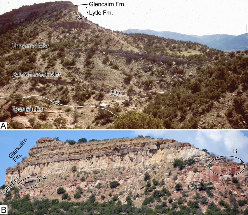
GEOLOGY OF THE INTERMOUNTAIN WEST
                                                                               an open-access journal of the Utah Geological Association

                           Volume 6                                                                                                                       2019

Redefining the Upper Jurassic Morrison Formation in the Garden Park National Natural
Landmark and Vicinity, Eastern Colorado
Ken Carpenter1,2 and Eugene Lindsey3
1
 Prehistoric Museum, Utah State University Eastern, Price, UT 84501; Ken.Carpenter@usu.edu
2
  Museum of Natural History, University of Colorado, Boulder, CO 80302
3
 Department of Earth Sciences, Denver Museum of Nature and Science, Denver, CO 80205 (deceased)
                                                                       ABSTRACT
          The Garden Park National Natural Landmark (GPNNL) is north of Cañon City, Colorado, and en-
     compasses all of the major historical dinosaur quarries of the Upper Jurassic Morrison Formation in this
     area. The formation there can be divided into the lower redefined Ralston Creek Member and an upper
     unnamed member. The Morrison Formation is bracketed below by the J-5 unconformity and above by the
     K-1 unconformity.
          The Ralston Creek Member is composed of up to 55 m of arkosic conglomerate, sandstone, siltstone,
     and gypsum conformably underlying the unnamed member. Fossil fishes previously used to infer a Middle
     Jurassic age are non-diagnostic. A diplodocid skeleton 4 m above the J-5 unconformity from the west-ad-
     jacent Shaws Park, and a radiometric date of 152.99 + 0.10 Ma from the Purgatoire River area demonstrate
     that the Ralston Creek rightly belongs in the Morrison Formation and correlates with the Tidwell and
     Salt Wash Members on the Colorado Plateau. The Ralston Creek was deposited in a broad playa complex
     analogous to those of central Australia and here called the Ralston Creek boinka. Groundwater flux played
     an important role in gypsum deposition in gypsisols and playa lakes. The overlying unnamed member in
     the GPNNL can be subdivided on the west side of Fourmile Creek into a lower part composed largely of
     mudstone with many thin, discontinuous channel sandstone beds, and a thicker upper part containing
     more persistent tabular sandstone beds; this subdivision does not occur east of Fourmile Creek. Several
     thin limestone beds occur in the Ralston Creek Member and in the lower part of the unnamed upper
     member. The limestone contains fresh water ostracods and aquatic mollusks indicating a lacustrine origin.
     However, these fauna are apparently stunted and the ostracod valves closed indicating periodic hypersaline
     conditions.
          All detrital rocks in the Morrison Formation at Garden Park are composed of varying amounts of
     quartz, potassic feldspar, and the clay minerals illite, smectite, and kaolinite. Mapping of the clay minerals
     in the unnamed member reflect various paleosols throughout the mudstone interval, including protosols
     and argillisols. At the top of the formation, a sandstone previously assigned to the Morrison is reassigned
     to the overlying Cretaceous Lytle Formation based on similar weathering characteristics, mineral content,
     and fabric. Thus, the K-1 unconformity between the Morrison and overlying Lytle rests on the uppermost
     occurrence of the Morrison Formation mudstone-sandstone-limestone complex and beneath the blocky,
     cliff-forming Lytle Formation.
Citation for this article.
Carpenter, K., and Lindsey, E., 2019, Redefining the Upper Jurassic Morrison Formation in Garden Park National Natural Landmark and vicinity,
eastern Colorado: Geology of the Intermountain West, v. 6, p. 1–30.
© 2019 Utah Geological Association. All rights reserved.
For permission to use, copy, or distribute see the preceeding page or the UGA website, www.utahgeology.org, for information. Email inquiries to GIW@utahgeology.org.

                                                                                 1
Redefining the Upper Jurassic Morrison Formation in the Garden Park National Natural Landmark and Vicinity, Eastern Colorado
                                                       Carpenter, K., and Lindsey, E.

                   INTRODUCTION                            nated by Cross (1894), and the West Alameda Parkway
                                                           road cut along the same hogback (now called Dinosaur
     The Garden Park National Natural Landmark Ridge) is the principle reference section for the Mor-
(GPNNL)—formely named the Garden Park Geologi- rison Formation and is attributed to Waldschmidt and
cal Resources Area—is managed by the Bureau of Land LeRoy (1944).
Management and encompasses all of the classic dino-
saur sites in the Upper Jurassic Morrison Formation
north of Cañon City, Colorado (figures 1, 2A, and 2B;
                                                                    Previous Studies in the GPNNL
Monaco, 1998; Carpenter, 1999; Foster, 2003). The Mor-         The Morrison Formation can be traced almost with-
rison Formation can be widely traced throughout the out interruption for about 200 km from its stratotype
western United States (Mook 1916; Craig and others, near the town of Morrison to Garden Park in south-cen-
1955). It was named by Whitman Cross (1894), with the tral Colorado. There, it is exposed along the canyon and
stratotype given for exposures immediately east of the tributaries of Fourmile Creek. The first, albeit brief, de-
town of Morrison, Colorado (figure 3A). The forma- scription of the Morrison Formation in Garden Park
tion was defined as “…prevailingly greenish, pinkish or was by Cross (1894) as part of his description of the
gray shales and marls. Sandstone occurs at the base and geology of the Pikes Peak area. This was followed by a
is also intercalated at numerous horizons in the upper more detailed description by Hatcher (1902), who at-
part of the section with varying development” (Cross, tempted to place stratigraphically the historic dinosaur
1894, p. 2). The age was assumed to be Jurassic based on quarries of O.C. Marsh (Yale University) and E.D. Cope
the dinosaurs collected in the vicinity of the type local- (Academy of Natural Sciences of Philadelphia). The first
ity. Ethridge (1896, p. 60–62) described the formation stratigraphic section was presented by Mook (1916),
in greater detail, but it was Lee (1920) who refined the who noted a thickness of 97.2 m (originally reported in
boundaries of the stratotype and published a measured feet as 319 ft). This contrasted with about 106.7 m (orig-
section.                                                   inally reported in feet as 350 ft) given by Cross (1894)
     More than two decades later, Waldschmidt and Le- and 137.2 m (originally reported in feet as 450 ft) by
Roy (1944) designated the West Alameda Parkway road- Hatcher (1902). The disparity in thickness is due to lack
cut 2.5 km north of Morrison, Colorado, as a new stra- of agreement for the upper contact with the Cretaceous
totype for the Morrison Formation (figure 3B) and this beds. Subsequent studies on the Morrison of Garden
is still widely followed (e.g., Lockley and others, 2015). Park prior to the start of our work were mostly theses
Their justification for moving the stratotype was based or dissertations, with a few exceptions (Giltner, 1953;
on the entire Morrison Formation being exposed along Schulze, 1954; De Lay, 1955; Saylor, 1955; Frederiksen
the road cut, which had been only completed a few years and others, 1956; Hassinger, 1959; Sackett, 1961; Cram-
before, and because the exposure was readily accessible. mer, 1962; Brady, 1967; Enciso, 1981; Sweet, 1984a;
Such a relocation of the stratotype was not addressed by Johnson, 1991).
the stratigraphic code operating at the time (Committee        Beginning in the early 1990s, the Denver Museum
on Stratigraphic Nomenclature, 1933), but the current of Natural History (now the Denver Museum of Nature
North American Stratigraphic Code forbids it: “Once a and Science) began detailed paleontological and geo-
unit or boundary stratotype section is designated, it is logical studies there. The result of these studies are pre-
never abandoned or changed; however, if a stratotype sented in Ague and others (1995), Harris and Carpen-
proves inadequate, it may be supplemented by a prin- ter (1996), Small and Carpenter (1997), Alf (1998), Bray
cipal reference section …” (North American Commis- and Hirsch (1998), Carpenter (1998a, 1998b, 2019),
sion on Stratigraphic Nomenclature, 2005, Article 8(e)). Carpenter and Tidwell (1998), Evanoff and Carpen-
Therefore, the stratotype for the Morrison Formation ter (1998), Harris (1998), Kirkland and others (1998),
remains on the western face of the hogback on the east McIntosh and Carpenter (1998), Tidwell and Carpen-
edge of the town of Morrison as was originally desig- ter (1998), Brill and Carpenter (2001), Chure (2001),

Geology of the Intermountain West                                  2                                                       2019 Volume 6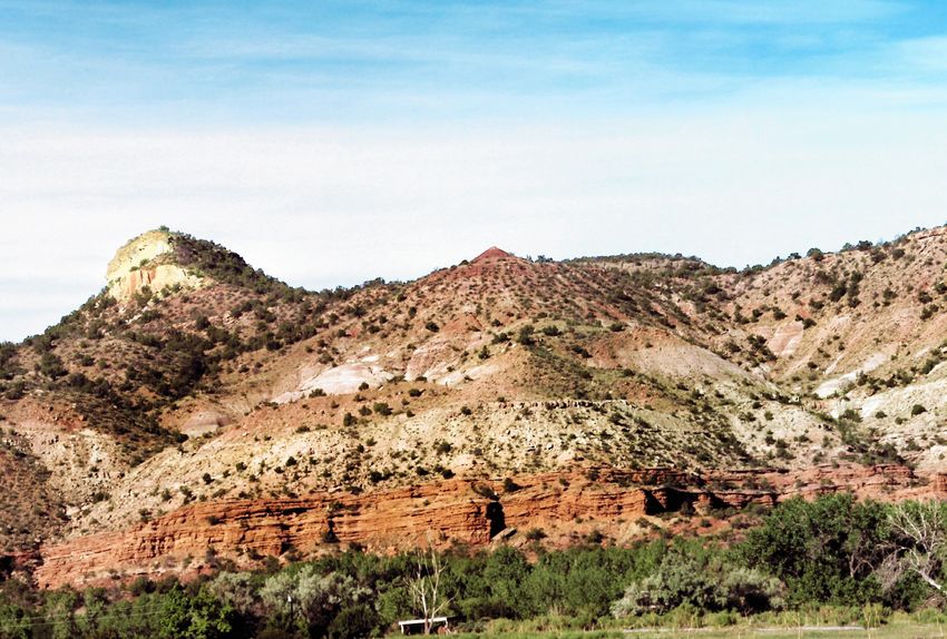
Redefining the Upper Jurassic Morrison Formation in the Garden Park National Natural Landmark and Vicinity, Eastern Colorado
                                                      Carpenter, K., and Lindsey, E.

Figure 1. Simplified geological map of the Garden Park National Natural Landmark, which is about 9 km north of Cañon
City, Colorado. Map courtesy of E. Evanoff (University of Northern Colorado).

Geology of the Intermountain West                                  3                                                      2019 Volume 6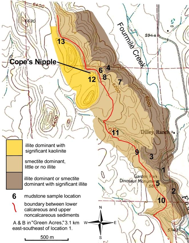
Redefining the Upper Jurassic Morrison Formation in the Garden Park National Natural Landmark and Vicinity, Eastern Colorado
                                                       Carpenter, K., and Lindsey, E.

Figure 2. (A) Felch Quarry 1 is in the lower part of the unnamed member of the Morrison Formation. A marked change oc-
curs from the alternating thin beds of greenish-gray mudstone and sandstone underlying the channel sandstone beds, which
lie immediately below the quarry floor, to mixed red and gray bentonitic mudstones above. (B) Cope’s Nipple Quarry in the
upper part of the unnamed member. The illitic mudstone beds are predominately red to maroon with some green lenses. The
sandstone beds in this interval are mostly tabular.

McWhinney and others (2001), and Rougier and others                    4B, and 4D). This unconformity, the J-5, represents a
(2015). Ancillary work on the stratigraphy of Morrison                 time gap of approximately 159 million years. The un-
Formation in Garden Park are presented in Peterson                     named upper member (the “traditional” Morrison of
and Turner (1998) and Turner and Peterson (1999).                      previous usage in eastern Colorado) is overlain by mas-
                                                                       sive sandstone beds of Cretaceous age originally called
                          Methods                                      the Dakota Formation by Cross (1894). Scott and others
                                                                       (1978) and Wobus and others (1985) placed these sand-
    As part of our work on the geology of the Morrison
                                                                       stones in the Lower Cretaceous Purgatoire Formation
Formation in the Garden Park area, one of us (Lindsey)
                                                                       in their mapping around Cañon City and Garden Park,
prepared a geological map for a 1.25 km2 area west of
                                                                       following the terminology of Finlay (1916) for south-
Fourmile Creek where most of the classical dinosaur
                                                                       ern Front Range northeast of Cañon City. They further
quarries are located (e.g., figure 2). Thin sections of
                                                                       subdivide the Purgatoire into the basal Lytle Member,
sandstone samples from the upper unnamed member
                                                                       a sandstone, and the overlying Glencairn Member, a
were examined with a petrographic microscope, and
                                                                       sandstone and shale unit. Kues and Lucas (1987) and
clay minerals in mudstone samples were analyzed with
                                                                       Mateer (1987) proposed abandoning the term Purga-
X-ray diffraction. The results of these analyses were
                                                                       toire Formation and elevating the Lytle and Glencairn
used to help reconstruct paleoenvironments at the time
                                                                       to formation status, a proposal accepted by us. Com-
of deposition.
                                                                       bined, these two Cretaceous formations are about 91 m
                                                                       thick in the Garden Park area.
   MORRISON FORMATION OF GPNNL                                             The placement of the K-1 unconformity between
   We divide the Morrison Formation throughout                         the Morrison and Lytle Formations is controversial.
GPNNL into two members; the lower Ralston Creek                        Two massive cliff-forming sandstone beds cap the me-
Member (new ranking) and an unnamed upper mem-                         sas throughout Garden Park (figures 4A and 5). Peter-
ber (figures 4A and 4B). The Ralston Creek Member                      son (U.S. Geological Survey, verbal communication
unconformably overlies the conglomeratic, brick-red to                 to Lindsey, 1995; see also Peterson and Turner, 1998,
orange Pennsylvanian Fountain Formation (figure 4A,                    figure 5) described a maroon-colored paleosol marking
Geology of the Intermountain West                                  4                                                       2019 Volume 6
Redefining the Upper Jurassic Morrison Formation in the Garden Park National Natural Landmark and Vicinity, Eastern Colorado
Carpenter, K., and Lindsey, E.
93
Figure 3. Morrison Formation
58
west of Denver. (A) Type locality
of the Morrison Formation on the
121
west facing slope of the Dakota
Golden
6 Hogback immediately behind the
Colfax Ave
town of Morrison (foreground).
40
Denver This 1899 photograph was taken
6th Ave
6
five years after the naming of the
Morrison Formation by Cross
40 26
Alameda Ave (1894). Quarry 10 of Arthur Lakes
from which Apatosaurus ajax
Wadsworth Blvd
was excavated is circled. (B) The
y
kw
aP
93
"type" locality of Walschmidt and
ed
am
LeRoy (1944) along the Alameda
Al
Hog B
B
Enlarged Parkway at what is now Dinosaur
ack R
Area
8 Ridge. Photograph in (A) is from
d
470
A Colorado Denver Public Library, Western
74
121 N History Collection X-11159. In-
Morrison
8
0 1 2 3 4 5 kilometers
dex map by Doug Sprinkel (Utah
3 miles
0 1 2
Geological Survey).
the K-1 unconformity at the top the lower sandstone with scarce microcline, and 1% to 5% maroon iron ox-
identified as Morrison. This is seen, for example, on ide. In contrast, sandstones in the unnamed member
the southeast side of Cottage Rock (figure 5B) and on are heterolithic, coarser grained, have larger quantities
the unnamed butte immediately west of Cope’s Nipple. of cement that range from calcite to clay and oxide mix-
Both sandstone beds 1 and 2 (figure 5B) are composed tures, and all have potassic feldspars. In light of these
of 95% rounded quartz grains, 0.2 to 0.8 mm, and an in- observations, we conclude that paleosol of Peterson and
terstitial mosaic of subangular quartz grains measuring Turner (1998) is a local diagenetic feature and we place
0.02 to 0.04 mm. Both are cemented with a mixture of the K-1 unconformity 15 m lower (figure 5B) at the base
clay and iron oxide comprising 5% of the rock. Feldspar of the lower sandstone (no. 1) of the Lytle Formation.
and calcite are absent in both. Petrographic examina- We also note that there is a local intra-Lytle erosion sur-
tion shows paleosol of Peterson and Turner (1998) to face at the top of lower sandstone (no. 1; figure 5B).
be composed of 75% to 85% subrounded quartz grains Overlying the Lytle Formation is the Glencairn For-
measuring 0.2 to 0.5 mm, 10% to 15% potassic feldspar, mation. It is the uppermost rock on most of the larger
Geology of the Intermountain West 5 2019 Volume 6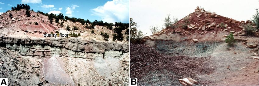
Redefining the Upper Jurassic Morrison Formation in the Garden Park National Natural Landmark and Vicinity, Eastern Colorado
                                                       Carpenter, K., and Lindsey, E.

Figure 4. (A) View west across Fourmile Creek from County Road 9 towards Cope’s Nipple and the “Valley of Death” (see fig-
ure 1). The J-5 unconformity is visible as the abrupt contact between the Pennsylvanian Fountain Formation and the Ralston
Creek Member of the Morrison Formation. This is about 16 m lower than placed by Peterson and Turner (1998) noted on
the right side (J-5 of P&T). The lithological and color change marking the lighter colored lower and pinkish upper portions
(generally more vegetated reflecting a change in soil clay minerals) of the unnamed member is visible below Cope’s Nipple
and in the Valley of Death. The Cretaceous Lytle Formation has a lower (1) and upper (2) sandstone. The K-1 unconformity
is at the base of sandstone 1. (B) Ralston Creek Member in Shaws Park, showing the location of the diplodocid quarry 4 m
above the Fountain Formation. Downslope wash of weathered Ralston Creek hides most of the abrupt contact of the J-5 un-
conformity. (C) Angular quartz pebbles of the conglomeratic sandstone in the diplodocid quarry. Camera lens cap ~7.5 cm
across. (D) Channel sandstone about 2 m above the J-5 unconformity at the top of the orange-colored Fountain Formation,
west side of Fourmile Creek. Photograph in A, courtesy of Dan Grenard (retired, Bureau of Land Management, ) and D. Vicki
Garrisi (True West Properties).

Geology of the Intermountain West                                  6                                                       2019 Volume 6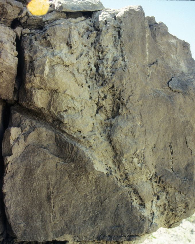
Redefining the Upper Jurassic Morrison Formation in the Garden Park National Natural Landmark and Vicinity, Eastern Colorado
                                                      Carpenter, K., and Lindsey, E.

Figure 5. (A) West side of Shaws Park showing the entire Morrison Formation below an unnamed butte. The reddish colors
characteristic of the upper part of the formation along Felch Creek are absent here. (B) Cretaceous Lytle Formation sand-
stone beds 1 and 2 below the capping Glencairn Formation on Cottage Rock. Purple paleosol A and red paleosol B were
considered the K-1 unconformity by Peterson and Turner (1998). We place the K-1 below sandstone 1. Photograph courtesy
of Vicki Garrisi (True West Proerties).

mesas in Garden Park (figures 4A, 5A, and 5B). It is a and contradictory depositional histories.
tan to olive, thin-bedded sandstone with some shale
layers. Sand grains range from medium to coarse and                    Nomenclature History
are rounded. Calcite is absent. Quartz comprises 85%
to 90% of the rock and iron oxide and clay cement is         In the Cañon City embayment (which includes
about 5%.                                                Garden Park at the north), the Morrison Formation
                                                         rests upon strata that have been called the Ralston For-
                                                         mation (De Lay, 1955; Frederickson and others, 1956;
      THE RALSTON CREEK MEMBER
                                                         Hassinger, 1959; Sackett, 1961; Cramer, 1962), the
    We reassign the strata previously called the Ralston Ralston Creek Formation (Brady, 1967, 1969; Enciso,
Creek Formation as the lowest member of the Morrison 1981; Sweet, 1984a; Carter, 1984; Gong, 1986; Richard-
Formation in Garden Park, along the Front Range, and son, 1987; Johnson, 1991; Anderson and Lucas, 1994),
in the Denver Basin. Doing so eliminates lithostrati- the “Ralston Creek Formation” (in quotes, Schultze and
graphic correlation inconsistencies, conflicting ages, Enciso, 1983), the Todilto Formation (De Ford, 1929;

Geology of the Intermountain West                                  7                                                      2019 Volume 6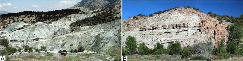
Redefining the Upper Jurassic Morrison Formation in the Garden Park National Natural Landmark and Vicinity, Eastern Colorado
                                                       Carpenter, K., and Lindsey, E.

Heaton, 1950), the Wanakah Formation (Schaeffer and                    Cañon City embayment and south along the east side
Patterson, 1984), and the Bell Ranch Formation (Peter-                 of the Wet and Sangre de Cristo Mountains, the Ralston
son, 1994; Peterson and Turner, 1998; Turner and Peter-                Creek includes arkosic conglomerate, sandstone, and
son, 1999). Other names that have been applied to the                  mudstone that probably represent alluvial fans com-
strata in the northern part of the Front Range, which                  ing off the remnants of the ancestral Rocky Mountains
marks the western edge of the Denver Basin, include the                (De Ford, 1929; De Lay, 1955; Fredrickson and others,
Windy Hill Sandstone Member of the Sundance For-                       1956; Metz, 1959; Hassinger, 1959; Sackett, 1961; Cra-
mation (Pipiringos and O’Sullivan, 1976; Imlay, 1980)                  mer, 1962; Johnson, 1991). Calcite and dolomite are
and Canyon Springs Member of the Sundance Forma-                       common carbonate minerals in the non-gypsum facies
tion (Pipiringos and O’Sullivan, 1978). The same strata                as either cement, limestone, or calcrete (Carter, 1984;
in southeast Colorado have been referred to as the part                Gong, 1986; Richardson, 1987).
of the Morrison (Lee, 1902), an unnamed “middle unit
of Jurassic age” (Oriel and Mudge, 1956), Bell Ranch                            Ralston Creek Member Contact
(Prince, 1988), and Ralston Creek (Hager, 2015). In
Kansas, the gypsum-rich strata are included in the base                    The contact between the Ralston Creek (Member)
of the Morrison Formation (Merriam, 1955).                             and Morrison (unnamed member of the Morrison For-
     The Ralston Formation [sic] was proposed in Le-                   mation [our usage]) was placed by LeRoy (1946, p. 53)
Roy's (1944) dissertation and officially published two                 at a disconformity below the “basal sandstone of the
years later (LeRoy, 1946). The strata lay between the Ly-              Morrison.” This criterion assumed that the lowest sand-
kins and Morrison Formations on the west side of the                   stone cropping out intermittently from the talus, soil,
Dakota Hogback west of Denver, Colorado. Van Horn                      and vegetation was the same all along the Dakota Hog-
(1957) amended the name to the Ralston Creek Forma-                    back. Later work demonstrated that this was not the
tion because two other formations were already named                   case. Instead, the basal Morrison sandstone was actu-
Ralston (principle of homonymy, North American                         ally lenticular sandstone bodies that were laterally dis-
Commission on Stratigraphic Nomenclature, 2005, Ar-                    continuous and were at slightly different stratigraphic
ticle 7(b)). LeRoy (1946) designated the stratotype at the             positions relative to one another (Scott, 1963; Johnson,
southwest end of Ralston Reservoir for 25.3 m (original-               1991). Elsewhere in eastern Colorado, various conflict-
ly reported in feet as 83 ft) of thin beds of predominately            ing criteria have been used to mark the contact: (1) the
gray shale and marlstone, and yellow sandstone and silt-               combination of loss of gypsum, presence of limestone,
stone. The selection of this stratotype is unfortunate be-             welded cherts, and ledge-forming, massive sandstone
cause the strata there are not typical of the gypsiferous              beds (De Lay, 1955; Saylor, 1955; Frederickson and oth-
Ralston Creek that underlies most of the Denver Basin.                 ers, 1956; Carter, 1984), (2) the top of the highest chert
LeRoy (1946) noted that the gypsiferous facies in the                  bed (Oriel and Craig, 1960), (3) the base of the low-
Ralston occurred about 19.5 km south near the town                     est sandstone (Sackett, 1961), (4) the top of the high-
of Morrison. It is unfortunate that LeRoy did not con-                 est conglomerate and gypsum bed or color change to
tinue to trace the Ralston Creek farther south along the               gray and green mudstones (Cramer, 1962; Brady, 1967),
Front Range because the gypsum-free shale-marlstone                    (5) the first laterally extensive limestone bed (Enciso,
(i.e., mudstone and calcareous mudstone) facies of the                 1981), (6) at the base of the lowest welded chert (Sweet,
stratotype was atypical. Throughout eastern Colorado,                  1984a; Peterson and Turner, 1998), (7) the change from
the Ralston Creek mostly consists of variegated mud-                   sand-sized grains to clay-sized grains and loss of gyp-
stone (mostly shades of gray and green with some red)                  sum (Prince, 1988), and (8) at the top of a blue chert bed
interbedded with gypsum (including some anhydrite)                     (Hager, 2015). Giltner (1953), Merriam (1955), Johnson
beds, and sandstone (Heaton, 1939; Saylor, 1955; Fred-                 (1959), and Johnson (1991) concluded that no solution
rickson and others, 1956; Johnson, 1962; Prince, 1988;                 was possible and included the lithofacies in the Morri-
Johnson, 1991; Hager, 2015). In the western part of the                son Formation. In doing so, they reverted back to the

Geology of the Intermountain West                                  8                                                       2019 Volume 6
Redefining the Upper Jurassic Morrison Formation in the Garden Park National Natural Landmark and Vicinity, Eastern Colorado
Carpenter, K., and Lindsey, E.
definition of the Morrison Formation given by Cross ber is predominately composed of 21 to 24 m of gray,
(1894) and Mook (1916), which included gypsum beds. greenish-gray to light-brown sandstone, siltstone, and
The use of the welded chert boundary is strongly ad- mudstone, and lesser amounts conglomerate. The con-
vocated by Peterson and Turner (1998) as a nearly iso- glomerate beds, mostly confined to the lower part, are
chronous boundary in the lower part of the Morrison composed of subrounded- to rounded, pebble- to pea-
Formation. King and Merriam (1969) contend that the sized fragments of quartz (figure 4C) and metaintru-
source of the silica forming the welded chert is from the sives derived from the reddish Pikes Peak Granite of
devitrification of glassy volcanic ash fall. This hypoth- late Mesoproterozoic age (1.1 Ga, Anderson and Cull-
esis is supported by the discovery of partially devitri- ers, 1999). The sandstone beds consist of subrounded
fied glass shards in the Morrison of the Front Range by to well-rounded, coarse- to fine-grained sand, and the
Keller (1962; see also Johnson, 1991). Using the welded siltstone beds are composed of quartz and potassic feld-
chert in the Morrison, however, is at odds with how it spar grains with calcite cement. The quartz:feldspar ra-
was first described by Ogden (1954, p. 914), who iden- tios range between 70:30 and 90:10. Together, quartz
tified the welded chert as “near the top of the Ralston and feldspar comprise 40% of the rock at the base of the
formation” and used that to correlate with occurrences formation and 75% near the top. Clay content ranges
in the Sundance Formation of northern Colorado and from 50% at the base of the formation to 10% to 15%
Wyoming. near the top. East of Fourmile Creek, along the north
In Garden Park, both Hassinger (1959) and Sweet facing scarp of Felch Creek (figure 6A), the Ralston
(1984a) noted that welded chert beds occurred in fa- Creek is composed of sandstone, siltstone, mudstone,
cies identified as the lower Morrison Formation; welded and some thin gypsum beds. The gypsum content in-
chert is seen, for example, in sandstone beds near the creases eastwards across the Cañon City embayment
bridge across Fourmile Creek. Prince (1988) on the oth- (figures 6B and 6C) as noted by De Lay (1955), Fred-
er hand, noted a change in the stratigraphic position of rickson and others (1956), Cramer (1962), and Carter
the welded chert from near the top of the Ralston Creek (1984). Poorly preserved fossil fish have been recovered
lithofacies to near the bottom of the Morrison lithofa- from sandstone beds near the base along Felch Creek
cies along the Purgatoire River. Cramer (1962) noted (Dunkle, 1942; Schultze and Enciso, 1983; Schaeffer
that the chert is common in a 18.3-m-thick (originally and Patterson, 1984), and are discussed further below.
reported in feet as 60 ft) zone of calcareous sediments Composition of the conglomerate and mineral con-
that span Ralston Creek and Morrison lithofacies. En- tent of the sandstone and siltstone beds suggest that
ciso (1981) concluded that the cherts represented silici- the Ralston Creek Member received sediments from
fied evaporites and discounted the importance of the the same source as the underlying Fountain Forma-
welded cherts as a reliable marker. Joeckel and others tion, and/or that the Ralston Creek is derived, at least
(2007) also noted that chert replaced evaporites in the in part, from reworking the Fountain; this is elaborated
Morrison of Kansas. At best, we conclude that the weld- further below. A partial diplodocid sauropod skeleton
ed chert zone is a broad band that straddles the upper was collected in this conglomeratic facies 4 m above the
Ralston Creek and lower Morrison lithofacies and is not Fountain Formation near the Shaws Park-Garden Park
a reliable isochronous surface; it may define a broad zone divide (figures 4B and 5A); it is under study by Virginia
affected by changing groundwater chemistry during the Tidwell (volunteer, Denver Museum of Nature and Sci-
Late Jurassic (see further below). Whether this holds ence).
true for the welded cherts in other formations, such as Age of the Ralston Creek Member
the Sundance, we cannot say.
The correlation of the Ralston Creek Member along
all or part of the Front Range to the Cañon City embay-
Ralston Creek Member in Garden Park
ment has been demonstrated by De Lay (1955), Saylor
West of Fourmile Creek, the Ralston Creek Mem- (1955), Frederickson and others (1956), and especial-
Geology of the Intermountain West 9 2019 Volume 6Redefining the Upper Jurassic Morrison Formation in the Garden Park National Natural Landmark and Vicinity, Eastern Colorado
Carpenter, K., and Lindsey, E.
Figure 6. Lateral changes in the Ralston Creek Member. (A) Exposure along Felch Creek, east of Fourmile Creek with prom-
inent sandstone lenses in the lower part and thinner calcic sandstone, siltstone, and mudstone beds in the upper; some
gypsisol horizons also occur in this upper part. (B) Alternating petrogypsic horizons, mudstone and sandstone at Cram-
er’s (1962) measured section 12 in Eightmile Park. This site is about 12.2 km southeast of (A). (C) Repetitious alternating
gray-weathering gypsisols, and gypsiferous fine-grain sandstone and grayish-green mudstone of a playa margin facies in a
road cut of Colorado State Highway 115, 21.5 km east of (A). (D) Alternating thin, laterally discontinuous gypsum beds,
reddish- to greenish-gray mudstone with nodular gypsum along the Purgatoire River, PRC site of Hager (2015); 173.75 km
southeast of (A). Rock hammer for scale. Photograph (D) courtesy of Paul Myrow (Colorado College).
ly Johnson (1991). Their results contrast with Peterson and therefore older than the type Ralston Creek west of
and Turner (1998) who are of the opinion that the strata Denver” (Peterson and Turner, 1998, p. 26). The Mid-
in Garden Park cannot be assigned to the Ralston Creek dle Jurassic age was inferred from the fish taxa Hulet-
because “some of these beds are Middle Jurassic in age tia americana and Todiltia schoewei that were reported
Geology of the Intermountain West 10 2019 Volume 6Redefining the Upper Jurassic Morrison Formation in the Garden Park National Natural Landmark and Vicinity, Eastern Colorado
Carpenter, K., and Lindsey, E.
from near the base of the strata along Felch Creek (Enci- of the Ralston Creek along the Purgatoire River (figure
so, 1981; Schultze and Enciso, 1983; Schaeffer and Pat- 6D). Schumacher (reported in Hager, 2015) obtained a
terson, 1984). These taxa are also present in the Todilto U-Pb date of 151.46 ± 3.1 Ma in the same general area
Formation of New Mexico and in the Hulett Sandstone from an ash just above the upper-most gypsum bed in
Member of the Sundance Formation in the Big Horn traditional Morrison lithofacies. These dates straddle
Basin, Wyoming (Schultze and Enciso, 1983; Schaeffer the Kimmeridgian-Tithonian boundary at 152.1 ± 0.9
and Patterson, 1984). Lucas and others (1985) using re- Ma (Cohen and others, 2013) and show that the Ralston
gional correlation concluded that the Todilto Formation Creek strata are coeval with the Salt Wash Member of
of New Mexico is middle Callovian, and Imlay (1982) the Morrison Formation of the Colorado Plateau (Tru-
concluded the Hulett Sandstone of Wyoming is lower jillo and Kowallis, 2015) and possibly the Tidwell
Callovian. Member as well.
Two crucial, but overlooked, comments regarding The younger age (Late Jurassic) for the Ralston
the specimens from Garden Park are that the specimens Creek strata does much to resolve the alleged 10 Ma-old
are poorly preserved (Dunkle, 1942) and are of juve- disconformity that is supposed to separate the Ralston
niles in which the diagnostic characteristic features of Creek and Morrison (unnamed member of our usage)
the adults are not yet developed (Schultz and Enciso, Formations (Schultze and Enciso, 1983; Schaeffer and
1983). The descriptions of Todiltia by Schultz and En- Patterson 1984; de Albuquerque, 1988; Anderson and
ciso (1983) are not of the Garden Park specimens, but Lucas, 1994, and others). We agree with De Ford (1929,
on the better-preserved specimens from the Todilto For- p. 78), Schulze (1954), Fredrickson and others (1956),
mation of New Mexico. Furthermore, Kirkland (1998) Hassinger (1959), Brady (1967, 1969), Enciso (1981),
described a second species of Hulettia—H. hawesi— Schultze and Enciso (1983), Sweet (1984a), Richard-
from the Morrison Formation suggesting that, at least son (1987), and Johnson (1991) that the contact is con-
at the generic level, Jurassic freshwater fishes may be formable, except locally beneath the lowest sandstone
long lived. However, Schultz (retired, University of of the typical Morrison (unnamed member of our us-
Kansas, verbal communications to Carpenter, 2017) is age). Peterson and Turner (1998, p. 27) acknowledged
not convinced that H. hawesi is diagnostic because the the difficulty in identifying an unconformity (contrary
crucial skull is unknown. At best, the specimens from to their figure 5); “the upper contact of a ‘Ralston Creek
the Ralston Creek strata indicate the presence of primi- Formation’ would have to be determined by the pres-
tive actinopterygians. Finally, if as we show below, the ence of a thick or moderately thick sandstone bed at the
Ralston Creek is nonmarine, then the fish from Garden base of a restricted Morrison Formation. But where a
Park were probably freshwater and are doubtfully the reasonably thick sandstone bed is absent, the similarity
same taxa as from the marine Sundance and Todilto of limestone-bearing red and green mudstone in both
Formations. We therefore contend that the Middle Ju- formations would make it difficult if not impossible to
rassic age for the Ralston Creek Member has not been establish a contact between the two formations.”
established based on the fossil fishes. In addition, it seems inconceivable for there not to
There is now evidence for a Kimmeridgian age be paleosol development in the mudstone marking the
for the Ralston Creek strata making it 10 Ma young- alleged 10 Ma disconformity or unconformity such as
er than previously considered. This evidence includes that seen separating the Upper Jurassic Morrison For-
the diplodocid skeleton collected 4 m above the Penn- mation from the Lower Cretaceous Cedar Mountain
sylvanian-age Fountain Formation in strata previously Formation in eastern Utah (e.g., Kirkland and Madsen,
identified as Ralston Creek (De Lay, 1955; Fredrickson 2007; Kirkland and others, 2016). Schulze (1954) and
and others, 1956; Enciso, 1981; Schultze and Enciso, Hassinger (1959) made a similar observation, noting
1983; Gong, 1986; Richardson, 1987 ), and a zircon that the gypsum at the top of the Ralston Creek does
206
Pb/238U weighted mean date of 152.99 ± 0.10 Ma re- not show erosion or weathering that would be expected
ported by Hager (2015, appendix C) from near the top for long subareal exposure.
Geology of the Intermountain West 11 2019 Volume 6Redefining the Upper Jurassic Morrison Formation in the Garden Park National Natural Landmark and Vicinity, Eastern Colorado
Carpenter, K., and Lindsey, E.
Finally, excluding the dubious identification of the eton found in the Jurassic near the Trias or red beds. It
fishes, other fossil evidence suggests a greater affinity shows several vert. and what looks to be the sacrum”
of the Ralston Creek with the Morrison Formation as (letter to John Hatcher, December 1, 1901, Carnegie
acknowledged by LeRoy (1946) and by Curtis (1963). Museum archives). Unfortunately, the skeleton cannot
Cramer (1962) reported palynomorphs from low in the be found in the Carnegie Museum collections. The “red
Ralston Creek strata in Garden Park, including the chei- beds” were assume by Hatcher (1902) to be Triassic but
rolepidiacean conifer Classopollis minor (abundant), are now known as the Pennsylvanian Fountain Forma-
the araucariacean Callialasporites dampieri (as Zonal- tion.
apollenites dampieri, common), Monosulcites sp. (com-
mon), and the caytoniaceous seed ferns Caytonipollen- Ralston Creek as a Member
ites sp. and Vitreisporites sp. (rare). Baghai-Riding and
others (2014) and Dangles and others (2014) report a Our proposal to include the Ralston Creek strata
small assemblage of palynomorphs from near Colorado in the Morrison Formation is not without precedence
Springs, which Paul Myrow (Colorado College, verbal as other authors have included Ralston Creek in the
communications to Carpenter, 2017) states is high in Morrison along the Front Range (Heaton, 1950; Im-
the Ralston Creek. Taxa include the ferns Ischyospo- lay, 1952; Boos and Boos, 1957; Grose, 1960; Pipirin-
rites marburgensis (abundant) and Cyathidites minor gos and O’Sullivan, 1976, in part; and Johnson, 1991).
(abundant), the cheirolepidiacean conifer Classopollis O’Sullivan (1992) even recommended designation of
(abundant), araucariacean conifer Araucariacites spp. the Ralston Creek as a member; “The gypsum-bearing
(rare), possible taxodiacean conifer Exesipollenites tu- beds in the Front Range embayment probably should
mulus (rare), and bisaccates (pine, voltziales, or podo- be assigned to the Morrison Formation as a lower
carp – rare), as well as the probable freshwater dinofla- member,” a conclusion we had independently reached
gellates Spiniferites and cf. Odontochitina (rare). as well. We therefore formally reassign (North Ameri-
Other plants reported from the Ralston Creek in- can Commission on Stratigraphic Nomenclature, 2005,
clude leaves of the cupressacean Elatides williamsoni Article 19(b)) the Ralston Creek as a basal member of
and the cone Palissya sp. (this identity is doubtful be- the Morrison Formation, with the stratotype at Ralston
cause Palissya is Rhaetian–Lower Jurassic, Pattemore Reservoir as originally designated by LeRoy (1946) for
and others, 2014), and the Kimmeridgian charophytes the “Ralston Formation” (North American Commis-
Aclistochara sp. and Echinochara spinosa (LeRoy, sion on Stratigraphic Nomenclature, 2005, Article 8(e)).
1946; Van Horn, 1957; Peck, 1957; Scott, 1962, 1963). The Ralston Creek has four lithofacies as first not-
Microbialites (mats, stromatolites, biolaminates) also ed by Frederickson and others (1956) that grade into
have been reported (Cramer, 1962; Enciso, 1981; de one another west-to-east: (1) a conglomerate facies
Alburquerque, 1988). Invertebrates include freshwater (figure 4b and 4C), (2) a sandstone facies (figure 4D),
gastropods Lymnaea morrisonensis and Gyraulus vet- (3) a gypsum-mudstone facies (figure 6B and 6C), and
ernus, the unionid cf. Vetulonaia faberi, and ostracods (4) a sandstone-mudstone-gypsum facies (figure 6D).
indent. (LeRoy, 1946; Van Horn, 1957; Scott, 1962, Owing to the contentious nature of the upper contact
1963). Yen (1952) noted that G. veternus is widely dis- in the gypsum-mudstone facies (see above), we place
tributed in the Morrison Formation. the contact with the overlying unnamed member at the
Vertebrate fossils include the diplodocid skeleton highest readily traceable gypsum or gypsiferous bed
in Shaws Park mentioned above, unidentified dinosaur (North American Commission on Stratigraphic No-
bones (Richardson, 1987), and large ornithopod tracks menclature, 2005, Article 23(a)). So defined, the con-
reported by Prince (1988). Another dinosaur skeleton tact is not isochronous, nor does it need to be (North
was reported in a letter by William Utterback from the American Commission on Stratigraphic Nomenclature,
Carnegie Museum who was digging at Cope’s Nipple 2005, Article 22 (e)). The bottom contact is the J-5 un-
(see Carpenter, 2019); “Have portions of a small skel- conformity, which is well expressed where: (1) the con-
Geology of the Intermountain West 12 2019 Volume 6Redefining the Upper Jurassic Morrison Formation in the Garden Park National Natural Landmark and Vicinity, Eastern Colorado
Carpenter, K., and Lindsey, E.
glomerate beds of the Ralston Creek Member lap onto ably, these conditions were present at the time of glau-
Precambrian granites west of Cañon City, (2) it overlies conite production in the Ralston Creek Member, with
the Pennsylvanian Fountain Formation in the GPNNL, a potassium source from the weathering of potassium
(3) it overlies the Triassic-age Lykins Formation east of feldspars in the Precambrian Pikes Peak granite. Finally,
Cañon City (figure 6B), and (4) it laps onto older rocks J. Ridgely (in Prince, 1988) noted that the geochemical
subsurface in eastern Colorado and western Kansas (De signature of the Ralston Creek gypsum is nonmarine in
Ford, 1929; Heaton, 1939; De Lay, 1955; Merriam, 1955; origin, which we look at next.
Saylor, 1955; Fredrickson and others, 1956; Oriel and Groundwater, not subaquatic precipitation, is the
Mudge, 1956; Hassinger, 1959; Sackett, 1961; Cramer, major source for nonmarine evaporites because ground-
1962; Schultz and Enciso, 1986; Richardson, 1987; de water leaches minerals from the surrounding sediments
Albuquerque, 1988; Prince, 1988; Johnson, 1991; Hager, and bedrock, and then precipitates evaporite minerals
2015). in arid and semiarid climates (Rosen, 1994; Warren,
2016). Rosen and Warren (1990a, 1990b) present five
Gypsum of the Ralston Creek Member criteria to distinguish between groundwater-formed
gypsum and subaquatic-formed (playa lake and marine
The gypsum facies of the Ralston Creek Member evaporite basin) gypsum, which we apply to the Ralston
have greatly influenced previous interpretations of the Creek gypsum: (1) individual gypsum layers are typi-
depositional environment. These hypotheses range from callyRedefining the Upper Jurassic Morrison Formation in the Garden Park National Natural Landmark and Vicinity, Eastern Colorado
Carpenter, K., and Lindsey, E.
Figure 7. Comparison of playa and marine gypsum. (A) Playa gypsum has vertically oriented crystals that formed within
soils of the playa margin. (B) These crystals grow by displacing the substrate silt and clay, which is crowded to edges, thus
outlining the crystals. (C) Slabbed section showing the internal crystal fabric and displaced substrate outlining the crystals.
Dark speckles in the center are tiny gypsum or selenite crystals; sample taken from just right of (B). Images (A) and (B) from
road cut in figure 6C. (D) Bed of weathered marine gypsum (center band) at the base of the Piper Formation (equivalent to
Sundance Formation) south of Big Pryor Mountain, Montana. (E) Marine gypsum is not dominated by vertically oriented
crystals as seen in a close-up of the weathered gypsum (black box in D). Displaced substrate outlines the crystals, which are
better seen in (F), a polished slabbed section (sample NH.101.11) on display at the Draper Museum of Natural History in
Cody, Wyoming (bright flares are reflections of display lights). This sample shows the characteristic “chicken wire” texture of
marine gypsum. Scales in cm.
vas, 2007; Warren, 2016), although context helps (e.g., dry most of the year. Rosen (1994) and Briere (2000)
marine invertebrates in associated shale or limestone). set an annual minimum for being dry at 50% and 75%,
On a regional scale, playa lake gypsum beds are inter- respectively. In the geological record, we can only make
spersed with gypsiferous paleosols (e.g., figures 6C and assumptions about how long a playa is dry annually.
6D) that formed in a zone marginal to the strandline. We assume from studies of modern playas that those in
For clarification, we use “playa” in the restrict- the geologic past were dry for a significant part of the
ed sense of Rosen (1994) and Briere (2000) with one year, thus our vague qualifier “most of the year.” A playa
slight modification; a playa is a discharging intraconti- complex is an intracontinental depositional basin that
nental basin with a negative water balance, remaining features multiple playas (see Jacobson and Jankowski,
Geology of the Intermountain West 14 2019 Volume 6Redefining the Upper Jurassic Morrison Formation in the Garden Park National Natural Landmark and Vicinity, Eastern Colorado
Carpenter, K., and Lindsey, E.
1989, figure 13; Warren, 2016, figure 2.22) and is the ancestral Rockies was insufficient to produce an effec-
concept we envision for the depositional environment tive rain shadow in the manner analogous to the Basin
of the Ralston Creek. and Range-created playas today (Rosen, 1994). Because
groundwater apparently could flow northwards down
Geologic Setting and Depositional the potentiometric gradient towards the Sundance sea,
Environment of the Ralston Creek Member the Ralston Creek depositional basin is a through-flow
or open playa complex as defined by Rosen (1994) and
The Ralston Creek was deposited in a broad, Chivas (2007). This through-flow groundwater system
575-km-wide basin that was bounded on the west by with local surface discharge (playa lakes) being sur-
the low remnants of the ancestral Rocky Mountains and rounded by topographically low relief is similar to a
on the east by the Cambridge arch-central Kansas uplift system called a boinka in Australia (Macumber, 1991;
(Merriam, 1955) (figure 8). The basin was also bounded Rosen, 1994).
on the south by the Sierra Grande (Apishpa) and Ci- The formation of gypsisols (as defined by Mack
marron arches (Prince, 1988), but was mostly open to and others, 1993) is a “bottom up” phenomenon due to
the north towards the Sundance sea, which was located evaporative pumping at the surface, whereas most soils
at this time in central or northern Wyoming. The base form from the top down. The predominance of gypsum
of the Ralston was deposited on an irregular terrain over other evaporites in the Ralston Creek Member is
with up to 33 m of relief (De Lay, 1955; Merriam, 1955; probably due to two equally important phenomena.
Frederickson and others, 1956; Richardson, 1987). The The first phenomenon is the attainment of a steady state
ancestral Rockies at this time were very low, and prob- flux ratio, whereby groundwater outflow (evaporation,
ably measured in tens to hundreds of meters, not thou- through-flow, etc.) to inflow is such that only one or two
sands of meters, because they were eroded and buried evaporite minerals precipitate rather than a spectrum
in the short time represented by Ralston Creek Member. (Wood and Sanford, 1990, in contrast to the brine evo-
If start of Ralston Creek deposition was about the same lution concept of Eugster and Hardie, 1978). As a result,
time as the start of the gypsiferous Tidwell Member on more soluble minerals such as halite, may never form.
the Colorado Plateau, then deposition of the Ralston Or if they do form when the flux ratio changes due to
Creek Member took about 4 million years (see Trujil- increase groundwater outflow (e.g., during drought),
lo and Kowallis, 2015). The inferred low profile of the they will quickly dissolve when the system returns to
Figure 8. Reconstruction of the Ralston Creek boinka, a huge complex of playa lakes and gypsisols. View towards the north
from what is now southeastern Colorado. The basin is bounded to the west by low remnants of the ancestral Rocky Moun-
tains, to the east by the Cambridge arch-central Kansas uplift, and along the south by the Sierra Grande (Apishpa) and Ci-
marron arches. The open northern end of the basin is marked by vegetation. Thick beds of gypsum east of the present Front
Range suggests long-lived playa lakes were present near the ancestral Rocky Mountains. Although the landscape may look
barren, it was probably covered with gypsophilic and other xeric plants (see discussion by Czaja and others, 2014).
Geology of the Intermountain West 15 2019 Volume 6Redefining the Upper Jurassic Morrison Formation in the Garden Park National Natural Landmark and Vicinity, Eastern Colorado
Carpenter, K., and Lindsey, E.
the steady state position with seasonal rain. Richardson unnamed member with the underlying Ralston Creek
(1987) reported salt pseudomorphs at the top of lime- Member across eastern Colorado and western Kansas.
stone beds in the Ralston Creek near Cañon City, and The termination of gypsum deposition was gradual as
Hager (2015) reported salt casts in the Ralston Creek the overtopping Morrison facies was deposited pro-
along the Purgatoire River. Presumably these are halite gressively farther eastward through time as evidence by
pseudomorphs or casts. The second phenomenon was the stratigraphic position of the gypsum facies relative
that inflow groundwater along the basin margins was to a tuff marker bed (Cramer, 1962). This sedimenta-
already saturated with dissolved gypsum from older, ry change was undoubtedly accompanied by a change
gypsum-rich bedrock present along the margins of the in groundwater chemistry, which probably resulted in
basin (e.g., Triassic Lykins Formation along the west formation of a welded chert zone. The progressive east-
side, and Permian Flower-Pot, Blaine, and Dog Creek ward shift in facies explains the observation by Fred-
Formations along the east side). A strong correlation be- erickson and others (1956) and Prince (1988) that the
tween gyspic soils and underlying gypsum-rich parent welded cherts are time transgressive.
rock has been noted before (e.g., Bockheim, 2014; Cas- The change in groundwater chemistry at this time
by-Horton and others, 2015). Gypsic soils also contain may explain the abundant lacustrine carbonates in the
gypsum nodules that may be up to several centimeters lower part of the Morrison Formation in eastern Col-
in diameter (Carter, 1984). In the Ralston Creek, these orado (Giltner, 1953; Prince, 1988; Dunagan, 1998).
nodules occur in mudstone, siltstone, and fine-grained What would have been playa lakes depositing gypsum,
sandstone, and may coalesce into discontinuous irregu- were now freshwater lakes maintained by groundwater
lar beds (e.g., figure 6C and 6D). (Dunagan, 1998). A shift in the outflow/inflow ratios
Based on the 152 Ma radiometric dates high in the during droughts may explain the presence of the occa-
Salt Wash and Ralston Creek Members (see above), the sional evaporites and temporary playa lakes (Giltner,
ancestral Rocky Mountains must have acted as a topo- 1953; Sweet, 1984a, 1984b; Dunagan, 1998).
graphic barrier between the two depositional systems As is typical for modern playa areas, eolian sand
(see Craig and others, 1977). As described above, con- grains (frosted, unimodal, and usually rounded) occur
glomerates in the western outcrops of the Ralston Creek in the Ralston Creek Member, with the thickest eolian
indicate low gradient alluvial fans on the eastern side of deposits downwind on the east side of the basin (Mer-
the remnant mountains, and the isopleth map of grain- riam, 1955; Frederickson and others, 1956). Some of
size distribution given by Craig and others (1955, fig- the grains are probably recycled from the older eolian
ure 27) shows a decrease in sorting in the eastern-most Entrada Sandstone. De Lay (1955) reported chert ven-
portions of the Salt Wash. A similar decrease in sorting tifacts near the base of the Ralston Creek in the west-
was cited by them as evidence for proximity of the Salt ern part of the Cañon City embayment. The presence
Wash in south-central Utah and northeastern Arizona of microbial mats, stromatolites, etc. (de Albuquerque,
to a source area. Thus, the eastern-most Salt Wash must 1988) indicates the presence of more permanent brine
have been deposited near a source area, which would lakes. These microbialites form in the strandline (War-
have been the western side of the ancestral Rockies. ren, 2016).
Termination of Ralston Creek deposition was
marked by overtopping of the ancestral Rockies as evi-
THE UNNAMED MEMBER
denced by the sandstone-mudstone facies of the typical
Morrison in unconformable contact with Precambri- The unnamed member of the Morrison Formation
an granites along the Wet Mountains (Brady, 1967), in in the GPNNL is what has traditionally been referred
the present day intermountain basins (e.g., North and to as the Morrison Formation since the introduction
Middle Park, Wellborn, 1977; South Park, Fisher, 1977; of the term “Ralston Formation” into the Cañon City
Fraser Basin, Shroba and others, 2010; Webster Park, embayment by DeLay (1955) and Saylor (1955) for the
De Ford, 1929), and in the conformable contact of the gypsiferous facies. The unnamed member is predom-
Geology of the Intermountain West 16 2019 Volume 6Redefining the Upper Jurassic Morrison Formation in the Garden Park National Natural Landmark and Vicinity, Eastern Colorado
Carpenter, K., and Lindsey, E.
inantly gray-green to rusty red mudstone, with many All of the historic dinosaur quarries in Garden Park
sandstone lenses, mostly discontinuous, but with a few occur in the unnamed member of the Morrison Forma-
thicker, more persistent beds (figure 4A; Evanoff and tion (see Carpenter, 1998b; Monaco, 1998). Therefore,
Carpenter, 1998). Color variations of the mudstone we discuss its sedimentology further. As noted above,
beds are in part stratigraphic and in part reflect the the unnamed member west of Fourmile Creek can be
oxidation state of the contained iron. In the vicinity of informally subdivided based on color. The lower part
Fourmile Creek, gray-green is the dominant color of the consists predominantly of pastel gray-green mudstone
lower part of the member, and various shades of reddish and light grayish-white to pastel green sandstone, which
color in the upper part (figure 2). This allows the mem- make up to 13% to 14% in the measured sections. Gray
ber to be subdivided informally here into lower and or green mudstone clasts from bank collapse are com-
upper parts. This two-part color separation is absent mon in some sandstone beds, such as Felch Quarry 1,
in the eastern portion of GPNNL (“Green Acres” area, showing that the gray and green colors of the mudstone
figure 9) and to the west in the Shaws Park area (figure
are primary in origin. The upper part of the unnamed
5A). A cyclical sandstone-mudstone unit lies at the base
member consists of predominately reddish to maroon
of the unnamed member along Fourmile Creek (fig-
mudstone, with lenses of green to greenish-gray pa-
ure 9B), which can be traced to below Felch Quarry 1
leosols (figure 2B; Carpenter, 2019). The mudstones are
(figure 2A). All detrital rocks in the unnamed member
predominately smectitic, but with an illite-kaolinite as-
are predominately clay, quartz, and potassic feldspar in
varying quantities, and with, or without, calcite cement. semblage (see below). Tabular reddish-white to yellow-
Thin limestone beds are also present in the lower part, ish-colored sandstone also occurs (figures 2B and 4A).
with one prominent bed in “Egg Gulch” (figure 1). The Correlations within the Morrison throughout Garden
different lithologies are discussed further below. Trujil- Park are difficult due to the discontinuous, lensy nature
lo and Kowallis (2015) report a single-crystal 40Ar/39Ar of the sandstone and limestone beds, and to Quaternary
laser probe date of 152.29 ± 0.27 Ma from a bentonite cover and landslide deposits that are mostly developed
mine in “Green Acres.” This mine is about 56 m above on the smectitic clays. A stratigraphic map and cross
the Ralston Creek Member (Peterson and Turner, 1998, section that features the entire stratigraphic section
figure 5 place the mine at 8 m above the Ralston Creek, of the Morrison Formation west of Fourmile Creek is
which is well below the bentonitic mudstone beds that shown on figure 10.
occur above the local clay change).
Figure 9. (A) Bentonitic green-gray mudstone beds of the middle and upper part of the unnamed member as exposed in
“Green Acres.” A bentonite mine 250 m to the left out of frame produced an 40Ar/39Ar date of 152.29 ± 0.27 Ma (Trujillo and
Kowallis, 2015). Two quarries in the area produced partial skeletons of Diplodocus longus and Camarasaurus grandis. (B)
alternating beds of thin sandstone and mudstone of the lower part of the unnamed member as exposed near the Fourmile
Creek bridge. Felch Quarry 1 is on the other side of the hill (see figure 2A). Photograph courtesy of Dan Grenard (retired,
Bureau of Land Management).
Geology of the Intermountain West 17 2019 Volume 6You can also read