Remote Sensing in Urban Forestry: Recent Applications and Future Directions - MDPI
←
→
Page content transcription
If your browser does not render page correctly, please read the page content below
remote sensing
Review
Remote Sensing in Urban Forestry:
Recent Applications and Future Directions
Xun Li 1 , Wendy Y. Chen 1 , Giovanni Sanesi 2 and Raffaele Lafortezza 1,2, *
 1    Department of Geography, The University of Hong Kong, Pokfulam Road, Hong Kong SAR, China;
      u3003456@connect.hku.hk (X.L.); wychen@hku.hk (W.Y.C.)
 2    Department of Agricultural and Environmental Sciences, University of Bari “Aldo Moro”,
      Via Amendola 165/A, 70126 Bari, Italy; giovanni.sanesi@uniba.it
 *    Correspondence: raffaele.lafortezza@uniba.it or raffa@hku.hk

 Received: 22 March 2019; Accepted: 8 May 2019; Published: 14 May 2019

 Abstract: Increasing recognition of the importance of urban forest ecosystem services calls for
 the sustainable management of urban forests, which requires timely and accurate information on
 the status, trends and interactions between socioeconomic and ecological processes pertaining to
 urban forests. In this regard, remote sensing, especially with its recent advances in sensors and
 data processing methods, has emerged as a premier and useful observational and analytical tool.
 This study summarises recent remote sensing applications in urban forestry from the perspective of
 three distinctive themes: multi-source, multi-temporal and multi-scale inputs. It reviews how different
 sources of remotely sensed data offer a fast, replicable and scalable way to quantify urban forest
 dynamics at varying spatiotemporal scales on a case-by-case basis. Combined optical imagery and
 LiDAR data results as the most promising among multi-source inputs; in addition, future efforts should
 focus on enhancing data processing efficiency. For long-term multi-temporal inputs, in the event
 satellite imagery is the only available data source, future work should improve haze-/cloud-removal
 techniques for enhancing image quality. Current attention given to multi-scale inputs remains limited;
 hence, future studies should be more aware of scale effects and cautiously draw conclusions.

 Keywords: remote sensing; urban forest; Ecosystem services; LiDAR; multi-source data

1. Introduction
     The world is experiencing accelerated urbanisation and growth of cities [1,2], which have
dramatically changed the urban landscape [3–5]. Though frequently escaping our notice, a mosaic of
fragmented habitats exists, ranging from remnant natural, modified natural, semi-natural, emulated
natural or entirely human-created, where diverse trees and other vegetation thrive [6,7]. Collectively,
all woods and trees within a city boundary are defined as an urban forest, including individual trees,
forest stands, and their associated biotic and abiotic components [8–11]. Complex forest patches
are a critical component of urban ecosystems. They provide a full spectrum of ecosystem services,
referring to the benefits that human populations obtain directly or indirectly [7,12,13] from natural
ecosystems [14,15], which serve as the basis of economic development and social wellbeing [16–18].
Some well-recognised and well-studied examples of urban forest ecosystem services include alleviating
summer heat through evaporation and shading [19,20], reducing stormwater runoff by intercepting
and absorbing water and improving infiltration [21,22], enhancing air quality by removing gaseous
pollutants and particulate matter [23], reducing greenhouse gas emissions by storing and sequestering
a considerable amount of carbon [24–27]; addressing food security by supplying food, medicine
and materials [28], pollination [29–31], outdoor recreation opportunities [1,32], as well as serving as
important places for aesthetics and spirituality [33,34].

Remote Sens. 2019, 11, 1144; doi:10.3390/rs11101144                      www.mdpi.com/journal/remotesensing
Remote Sens. 2019, 11, 1144                                                                          2 of 20

     In line with the increasing recognition of the importance of urban forest ecosystem services,
there are calls around the world for the adequate installation and sustainable management of urban
forests to maintain environmental health, improve the resilience of urban ecosystems, and enhance the
quality of urban life [2,35,36]. Given their great socio-ecological complexity and dynamics, urban forests
are by no means stationary [4,11,37]. The successful management of urban forests for the steady and
sustainable provision of a full spectrum of ecosystem services requires timely and accurate information
on the status, trends, and information about interactions between socioeconomic and ecological
processes pertaining to urban forests occurring at multiple temporal and spatial scales [2,35,38,39].
Traditionally, such information has been obtained by random field sampling and visual interpretation
of aerial photos, which are expensive, generally labour-intensive and time-consuming, and usually
cannot provide complete coverage of relatively large areas of interest [40–42]. These traditional
approaches have curtailed the accurate, consistent, replicable, and spatially explicit measurement
of spatiotemporal changes of urban forests and the associated evaluation of ecosystem service
provision [43,44]. Consequently, research faces challenges due to non-uniform and multifunctional
approaches, different methodologies, and a lack of relevant information [27].
     Fortunately, remote sensing, especially the latest advanced techniques and sensors (e.g.,
light detection and ranging LiDAR technology, hyperspectral imagery, high spatial resolution satellite
imagery), has emerged as a premier and useful observational and analytical tool that offers a fast,
replicable, objective, efficient, scalable, and cost-effective way to assess and quantify urban forest
dynamics at varying spatiotemporal scales [5,43,45]. For instance, the structural (3D arrangement
of vegetation, such as tree height, volume and size of foliage and stems), compositional (species
richness and diversity), and functional (ecological processes) characteristics of an individual tree,
urban forest patch, or all urban forests in large areas can be detected, measured, mapped, inventoried,
classified, monitored, modelled, and evaluated using remote sensing techniques [35,46]. Over the
past decade, the application of remote sensing in urban forestry, particularly the quantification of
biophysical dimensions of urban forests and associated ecosystem services, has increased [43,44,47,48],
although its use is still comparatively modest for studying spatially and spectrally complex urban
forest ecosystems [35,49].
     In this study, we aim to summarise recent applications of remote sensing in urban forestry from
the perspective of three distinctive themes, i.e., multi-source, multi-temporal, and multi-scale (referring
to studies conducted at different spatial scales) inputs. The state-of-art is evaluated on the basis of
empirical studies from the past decade. In particular, we exemplify how highly detailed and replicable
information on urban forests can be successfully derived from remotely sensed imagery over areas at
various spatiotemporal scales, which significantly surpasses the capacities of traditional inventory
or image analysis techniques [50]. Lastly, we discuss the potential of remote sensing to improve the
reliability and accuracy of mapping urban forest structural, functional and configurational properties
and dynamics, as well as of estimating a suite of ecosystem services.

2. Remote Sensing Applications in Urban Forests
     To summarise recent applications of remote sensing in the field of urban forestry, we focused
our search on research articles published in peer-reviewed journals, in English, within the time span
between January 2013 and March 2019. Multiple databases, including ISI Web of Science, Elsevier’s
Scopus, Google Scholar and ScienceDirect, were browsed using the terms “remote sensing OR LiDAR”
AND “urban forest OR tree OR plant OR vegetation OR greenspace”. More than 200 studies were
found to satisfy the aforementioned conditions. These studies were further filtered based on the
following criteria:

(1)   The research must focus exclusively on urban forests or greenspaces. Studies involving natural
      forests are excluded.
Remote Sens. 2019, 11, 1144 3 of 20
(2) The research must use remotely sensed data obtained from airborne/spaceborne imagery or
LiDAR. Studies involving data based on other techniques, such as pure photogrammetry or
terrestrial-based methods, are excluded.
(3) The research must involve at least one of the three themes: multi-source, multi-temporal,
and multi-scale inputs. Studies unrelated to any of these themes are excluded.
The final number of studies found totalled 63; these were classified in terms of 10 different
applications and three distinctive themes (Table 1). A detailed description of each study is reported in
Supplementary Materials. The articles cover remote sensing applications in diverse areas, including
measurement of urban forest attributes (e.g., biomass, species composition, canopy cover and spatial
configuration) and quantification of ecosystem services (e.g., carbon storage, water retention, air quality
improvement, and urban heat island mitigation). In the following sections, the articles are reviewed and
discussed in terms of the themes multi-source, multi-temporal and multi-scale input; their strengths
and limitations are summarised in Table 2.
2.1. Theme 1: Multi-Source Input
A shift from the use of single-source remote sensing data (11 of 63) to multi-source remote sensing
data (52 of 63) in urban forest studies has been observed thanks to the emergence of diverse airborne
and spaceborne platforms and the rapid development of remote sensing techniques. Examples of
these are the emerging very high spatial resolution (VHSR) and high spatial resolution (HSR) sensors,
hyperspectral sensors and high point density LiDAR technology. Table 3 lists the remote sensing
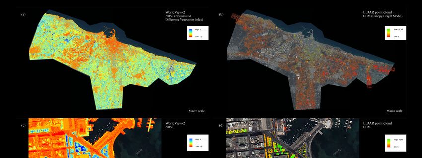
products/platforms used for urban forest studies. Two examples, as shown in Figure 1, are satellite
imagery (WorldView-2 NDVI) and LiDAR point-cloud data (canopy height model) applied to urban
forests at both macro- and micro-scale. Quantum leaps in computing power have enabled researchers
to fuse, process and model data from various sources at an unprecedented level of spatial and
temporal resolution.
2.1.1. Multiple Sources of Satellite Imagery
The combination of multiple sources of satellite imagery offers new potential in ecological research.
In fact, the majority of studies addressing the link between urban greenspace and urban heat island
rely on satellite images from multiple sources (Table 1). While HSR optical images, such as SPOT and
IKONOS, are able to classify vegetation coverage and other land uses at a fine level, these optical
sensors do not provide thermal infrared information. Indeed, land surface temperature has been
derived from other images with thermal bands, such as Landsat and Terra/MODIS sensors. As satellite
images from various sources complement one another, scientists overcome the technical challenges
associated with a limited spatial, spectral, temporal, and radiometric resolution by creatively combining
various satellite sources. Moreover, the increasing availability of free data is an incentive to utilise
multiple sources of satellite imagery. Although there are certain advantages of fee-based imagery
(e.g., very high spatial, temporal and spectral resolution) that cannot be replaced by open-access
data, these data sharing platforms allow researchers to download a variety of satellite images from
high-quality sources. Two such examples are the online platform operated by the United States
Geological Survey (USGS) (https://earthexplorer.usgs.gov/) and the Sentinel online platform operated
by the European Space Agency (ESA) (https://sentinel.esa.int/web/sentinel/home). Other ready-made
global/regional land cover and land use products, such as CORINE and Geo-Wiki, can be directly used
for analysis. Nonetheless, research should be the foremost consideration when it comes to the selection
of satellite imagery.
For example, Ren et al. [51] examined the relationship between urban park features and park
cool island intensity in Changchun, China using multi-source satellite imagery. The urban land
surface temperature was derived from Landsat-5 Thematic Mapper (TM) thermal band using the
mono-window method proposed by Qin et al. [52]. SPOT images were used to extract urban park
spatial features like size and shape.Remote Sens. 2019, 11, 1144 4 of 20
Kong et al. [53] used two sources of satellite imagery, IKONOS and Landsat-5 (TM) images,
to explore the impacts of spatial greenspace pattern on the urban heat island effect in a large metropolitan
area in eastern China. The HSR IKONOS images were used to classify land use into six types. Band 6
of Landsat-5 (TM) imagery was able to provide thermal infrared data that could be used to estimate
land surface temperature. Aligned with the spatial resolution of the land use map, the land surface
temperature map was resampled at 5 m × 5 m. The land use map was employed to calculate landscape
indices, which were used to estimate the spatial pattern of greenspace and to analyse its relationship
with land surface temperature. It was found that the greenspace pattern significantly influenced the
urban cooling effect. Greater urban cooling effects were observed in areas with a high percentage of
greenspace cover and level of greenspace fragmentation.
In addition to quantifying the urban cooling effect of urban greenspaces, multi-source remote
sensing has also been recently applied to address other research objectives. Modugno et al. [54] mapped
forest fires in the wildland-urban interface areas across Europe based on the harmonised land use and
land cover change map CORINE 2006. The CORINE land cover product derived from multi-source
satellite imagery is a commonly used dataset for European continental scale studies [55,56] and has
been updated every six years since 2000. The CORINE 2006 dataset selected in this study is based on
SPOT-4/-5 and IRS P6 satellite imagery. The forest fire information was extracted from the Burned
Surfaces Product, which was derived from the European Forest Fire Information System using MODIS
images. It revealed all forest fires burning 40 ha of surface area. Instantly accessible harmonised
datasets (e.g., CORINE land cover product and burned surfaces product) based on multi-source satellite
imagery have enabled researchers to evaluate attributes of urban forests with high efficiency.
In general, the application of the multi-source approach could be limited by two technical barriers.
First, weather conditions (e.g., haze and cloud coverage) and different image dates; both pose major
challenges and there is no guarantee that all images obtained within a certain time period are of high
quality for classification purposes. For example, in their 20-year temporal analysis, Di Leo et al. [57]
discarded poor-quality images affected by cloudiness or haze. The feasibility of using multiple sources
of satellite imagery should be a primary consideration, especially for time-sensitive research. Second,
satellite images are rarely available at both HSR and spectral resolution. Hyperion EO-1 imagery is
one of the few hyperspectral satellite images with 242 bands, yet it only has a spatial resolution of
30 m. Till now, few tree-level studies (e.g., identifying individual tree species and tree crowns) have
relied solely on multiple source applications of satellite images.
2.1.2. Satellite Imagery and Airborne LiDAR
Due to the strengths in providing spectral details and 3D point clouds, VHSR/HSR satellite
imagery and airborne LiDAR data were suited for the estimation of urban forest structure, attributes
and carbon storage. The integration of optical satellite imagery and LiDAR data allows us to identify
the urban forest structure more accurately in a complex urban environment. HSR multispectral imagery
is able to produce precise vegetation coverage, upon which LiDAR point-cloud data are based and can
be further used to estimate tree-level structure.
For example, Raciti et al. [58] mapped carbon storage of urban trees in Boston City using
LiDAR data coupled with VHSR satellite images. QuickBird imagery was first employed to derive
the Normalised Difference Vegetation Index (NDVI) values for extracting the vegetation cover.
Subsequently, 3D airborne LiDAR point-cloud data were used to delineate individual tree crowns
within the vegetation coverage. LiDAR-based tree height data were further used to estimate biomass
and carbon storage. The results showed that previous work using single-source remotely sensed data
tended to overestimate carbon storage in Boston. The QuickBird-LiDAR approach presented in this
study displayed high accuracy in estimating stereo features of urban trees, like volume and biomass.
Similarly, Schreyer et al. [59] developed a more specific method to combine LiDAR data and VHSR
satellite images to evaluate the carbon storage of urban trees in Berlin, Germany. Airborne LiDAR
was first employed to generate a digital surface model (DSM) and a digital terrain model (DTM).Remote Sens. 2019, 11, 1144 5 of 20
After a vegetation mask was created based on QuickBird imagery, the DSM and DTM were used to
derive a canopy height model (CHM). Using a two-step approach [60,61], dendrometric parameters
including tree location, number, height, crown width and diameter at breast height were generated
from the CHM. These parameters were then used to calculate carbon storage and distribution among
urban trees.
Parmehr et al. [62] used a novel data fusion strategy to identify urban tree canopy cover with
WorldView-2 imagery and airborne LiDAR data. The investigators adopted an automatic co-registration
method, which was proposed by Parmehr et al. [63]. The co-registration of satellite imagery to LiDAR
data is a process known as point-cloud colourisation. It attaches spectral information to the LiDAR
point cloud so that each colourised LiDAR point has additional RGB and NDVI values. The NDVI
values can improve the accuracy of identifying LiDAR tree points during the segmentation of trees
from other urban objects. Data fusion of LiDAR point-cloud data and spectral imagery has great
potential in increasing the accuracy of estimating tree structure in complex urban environments with
diversified tree canopy shapes and terrains.
While most recent studies agree that the combination of satellite imagery and LiDAR data can lead
to higher estimation accuracy, a publication by Singh et al. [64] challenges this consensus. The authors
found that with the help of a random forest classification method, LiDAR-derived topography metrics
could detect understory plant invasion in urban forests with the highest accuracy, exceeding IKONOS
data by 17.5% and combined LiDAR and IKONOS data by 5.3%. In this case, they inferred that the
temporal lag that took place between LiDAR and IKONOS data collection might have affected the
accuracy of identifying the fast-growing invasive species, Ligustrum sinense. The off-nadir effect of tall
trees [65] would also hamper HSR satellite imagery in detecting understory features in a heterogeneous
urban environment.
Although some researchers argue that airborne LiDAR alone is capable of producing an accurate
tree-level analysis, the abundance of spectral details provided by satellite imagery should be
corroborated; managed properly it can significantly enhance estimation accuracy as opposed to
using LiDAR data alone. Point-cloud colourisation is a promising technique for remote sensing data
fusion. By combining every LiDAR point with spectral information extracted from satellite imagery,
the colourised 3D point clouds with NDVI can be employed not only for segmenting individual trees
but also for distinguishing trees from their surrounding urban environments. Nonetheless, it should be
noted that the estimation accuracy of combining satellite imagery and LiDAR data would be reduced
if the fetch interval between the two data sources is relatively long, or if the research objects are
understory urban forests.
2.1.3. Satellite Imagery and Aerial Imagery
In practice, the combination of satellite imagery and aerial imagery has seldom been adopted,
given that aerial imagery can replace satellite imagery in terms of optical capability. Only when
extra data, such as infrared and thermal infrared data, are needed would such a combination become
necessary. The majority of recent publications utilising both satellite and aerial imagery (three of five)
have studied the mitigation effect of urban forests on the urban heat island. For example, Sung [66]
estimated how the woodlands’ tree protection policy adopted by The Woodlands Township, Texas,
USA, affected the urban heat island at the neighbourhood level. The author compared the land surface
temperature of two neighbourhoods in the woodlands and five control neighbourhoods in other urban
areas. The land surface temperature was obtained from the thermal bands of Landsat-5 (TM) imagery.
Unlike most urban cooling studies that used HSR satellite imagery to extract land use information,
this study exploited the US National Agricultural Imagery Program’s (NAIP) aerial imagery to classify
land cover at a fine scale. An object-based method was coupled with a support vector machine (SVM)
classifier to identify trees. When dealing with high-resolution imagery, object-based methods have
been reported to be superior to pixel-based methods for their ability to reduce noise and increase
accuracy [67,68]. Aerial imagery is superior to satellite imagery in terms of concurrent high spatialRemote Sens. 2019, 11, 1144 6 of 20
and spectral resolution. However, prohibitive flight costs limit its use to small/moderate areas. In the
US, NAIP has been offering aerial imagery with continental coverage during the agricultural growing
seasons to the public since 2003. NAIP imagery with four spectral bands is acquired at a 1-m ground
sample distance with horizontal accuracy that matches within 6 m of ground control points, which
can be used during image inspection and processing. A number of recent urban forest studies have
benefitted from free NAIP images.
2.1.4. Airborne LiDAR and Aerial Imagery
The integration of airborne LiDAR and aerial imagery has recently gained popularity in tree-level
urban forest inventories. It has great potential not only for enhancing estimation accuracy but also
for increasing the number of identifiable tree species. However, the limited coverage and expensive
flight costs of LiDAR hamper its use at a large scale. Alonzo et al. [69], for example, found that by
using fused HSR hyperspectral AVIRIS imagery with high point density LiDAR data, 29 common
urban tree species at crown level could be clearly identified. This was a substantial improvement
compared to 15 species identified using AVIRIS imagery alone, as reported in an earlier study [70].
Even though the addition of LiDAR data could increase the overall accuracy by only 4.2%, it was able
to enhance the classification accuracy of certain species, especially small crowned species, by more than
10%. Later, Alonzo et al. [43] found that fused airborne LiDAR and aerial imagery could outperform
field-plot data when measuring the uneven distribution of canopies across the city. Compared to
field-plot data, the consistency of airborne fused data is very suitable for measuring hard-to-access
urban areas or for large-scale measurements that require replication. These studies confirm the merits
of using hyperspectral imagery and LiDAR data fusion in mapping crown-level tree species in a highly
heterogeneous urban environment.
Zhang et al. [71] designed a framework to integrate airborne LiDAR data and aerial images for
a tree-level urban forest inventory. Above-ground points were separated from ground points in the
LiDAR data. The authors innovatively used NDVI values derived from hyperspectral images to
separate vegetation points from non-vegetation points. The ground points and vegetation points were
used to isolate individual trees with a treetop detection algorithm and a tree boundary extraction
algorithm. Lastly, tree species could be delineated in the hyperspectral images. Although this method
was able to increase the accuracy of tree-level identification, it was computationally demanding and not
scalable to larger spatial scales. Future work should focus on algorithm optimisation and computing
hardware upgrade to improve data processing efficiency.
The high point density of airborne LiDAR coupled with the high spectral resolution of aerial
imagery is an exciting approach for fine estimation. High-density 3D point clouds and high spatial and
spectral resolutions together can ensure high estimation accuracy. More importantly, unlike satellite
imagery, the quality of the fused data is not compromised by synoptic conditions, because the data are
obtained via active sensors. However, expensive flight costs and time-consuming data processing limit
its tractability for large-scale applications.
2.2. Theme 2: Multi-Temporal Input
Cross-sectional modelling of urban forest attributes and their ecosystem services might be
biased by unobserved factors. A useful strategy to mitigate this bias is to replicate observations
of the same units over time, thus time-invariant and location-specific unobserved factors can be
controlled [72]. In particular, multi-temporal remotely sensed data carry great potential for capturing
local details and have greater potential to improve estimation accuracy based on locally detailed
and spatially explicit data input. For example, using multi-temporal image data can increase the
success rate of mapping urban tree species composition as phenological information is retrieved [41,48];
this could be of vital importance for urban forests due to their compositional and configurational
complexity and heterogeneity. Due to such potential, empirical studies have made use of short or
long series multi-temporal remote sensing datasets to estimate changes in urban forest compositionalRemote Sens. 2019, 11, 1144 7 of 20
and configurational attributes (e.g., dominant species, forest age, canopy density); hence, a reliable
relationship between urban forests and the ecosystem services they provide is established.
2.2.1. Short Series Data Input
Some studies have utilised short series (usually only two) datasets to estimate changes in urban
heat island effects and the urban forest structure during a given time span, especially before and
after a certain event. Rogan et al. [73] integrated satellite and aerial images to examine the change in
urban heat island effect induced by eradicating the invasive Asian Longhorned Beetle, which caused
the elimination of 30,000 trees since 2008 in central urban areas in Massachusetts, USA. Landsat-5
(TM) thermal images acquired in the summertime in 2008 and 2010 were used to obtain land surface
temperature. NAIP images also acquired in both years during leaf-on conditions were used to extract
tree canopy cover. The authors found that the large amounts of tree loss and increased impervious
surface between 2008 and 2010 were significant in determining the increased land surface temperature.
Similarly, Landsat-5 and -8 images from 2004 and 2014 were examined to detect changes in urban
forest structure in Jinjiang city, southern China [74]. Combined together with ground observations and
spatial statistical modelling, the mechanisms that influence the surface temperatures of urban forest
canopies were successfully explored.
Qian et al. [75,76] utilised HSR and multispectral satellite images to explore the changes in urban
greenspace configuration induced by the 2008 Olympic Games in Beijing, China. Taking advantage of
both the HSR and multispectral features of SPOT and ALOS images taken in 2005 and 2008, fine-scale
greenspace coverage and landscape indices were derived for spatial analysis. The authors found
that holding the Olympic Games in Beijing not only incentivised the local government to increase
greenspace coverage but also changed the spatial pattern of greenspaces across the city.
2.2.2. Long Series Data Input
The majority of recent studies uses multi-temporal data to study changes in urban forests and the
induced socioeconomic and environmental effects based on long series data input (16 of 26). The ability
of multi-temporal remote sensing to monitor long-term changes in urban vegetation cover, urban
forest structure, and urban heat island is profound. Its potential also lies in monitoring changes
at various scales, from a small urban park to a metropolitan city and even to an entire region or
nation. Landsat imagery has been largely used by long-term studies owing to its long and continuous
time-series. MODIS imagery is also popular in urban heat island studies because it has a superior
temporal resolution than Landsat. The advantages of using multi-temporal satellite images for a
long-term, multi-temporal study are apparent: low cost, instant access, and short revisit period.
Yang et al. [77] estimated the changes in urban greenspace coverage in 30 major Chinese cities at
regional level between 1990 and 2010. Landsat-5 (TM) and Landsat-7 Enhanced Thematic Mapper Plus
(ETM+) images acquired in 1990, 2000 and 2010 were used to classify land cover into five types with
the SVM method. They found highly divergent trends of urban greenspace changes across different
cities, which could be explained by varied developmental patterns and government policies.
Adam and Smith [78] explored the relationship between vegetation cover and urban heat island
effect across the greater Sydney metropolitan region, in Australia. All available MODIS thermal band
scenes (102 in total) with less than 5% cloud cover in the summertime between 2000 and 2011 were
used as the land surface temperature index. The vegetation cover indices (e.g., foliage projective cover,
fractional cover of photosynthetically active vegetation) were extracted based on Landsat imagery
and ancillary data within the same time-series. All indices were resampled to 1 km2 to match MODIS
spatial resolution. Unlike most previous studies that employed single-phase remotely sensed data and
a single mode of measuring vegetation cover, the multi-temporal satellite imagery employed in this
study was capable of accounting for temporal variability and estimating the regional effects of varying
density and structure of vegetation cover.Remote Sens. 2019, 11, 1144 8 of 20
Bae and Ryu [79] examined the spatial and temporal variations of soil organic carbon stock in
a constructed urban park in Seoul, Korea, and explored how soil organic carbon stock was shaped
by land use and land cover changes. In their study, the NDVI values were derived from MODIS
data. Landsat-7 and -8 time-series images acquired between 2003 and 2013 were collected to measure
the temporal changes in NDVI values and land use pattern. Changes in the soil organic carbon
concentration of topsoil were quantified based on land use types. The results indicated that land
use history of the urban park played an important role in the temporal variations of the soil organic
carbon concentrations.
Di Leo et al. [57] explored the role of urban green infrastructure in mitigating the urban heat
island effect over 20 years in an urban area in sub-Saharan Africa. A total of 16 processed satellite
images acquired from Landsat-5 (TM), Landsat-7 (ETM+) and Landsat-8 Operational Land Imager and
Thermal Infrared Sensor (OLI/TIRS) between 1991 and 2013 were used to extract data on greenspace
cover and land surface temperature. Data alignment was required for multi-temporal images from
different Landsat sensors. On the one hand, the spatial resolutions of the thermal bands of the three
Landsat sensors were different: 120 m for Landsat-5, 60 m for Landsat-7, and 100 m for Landsat-8.
On the other hand, the thermal resolutions were also divergent: Landsat-5 and Landsat-7 had only one
thermal band (Band 6), while Landsat-8 had two thermal bands (Band 10 and Band 11). This study
demonstrates the advantages of multi-temporal satellite images in supporting spatiotemporal studies
of urban forests and the urban heat island. However, the insufficient number of high-quality periodic
satellite images for a 20-year analysis constitutes a critical limitation in this study.
Overall, for long-term high-frequency monitoring it is difficult to ensure that all images are
cloud-free, despite the tools available on Earth Explorer and Google Earth Engine that allow researchers
to select the most cloud-free scenes from the library. Sensor anomalies, as found with Landsat
(https://www.usgs.gov/land-resources/nli/landsat/landsat-known-issues), may also impact long-term
data collection. Accordingly, multi-source data are sometimes required to compensate the need for
high-quality images.
2.3. Theme 3: Multi-Scale Input
The relationship between urban forests and ecosystem services has been shown to vary across
space at different scales [72,80]. Indeed, one of the key advantages of remote sensing is its scalability.
Correspondingly, a more recent theme in remote sensing application in urban forests is the emergence
of multi-scale studies, expanding from micro-scale (e.g., individual tree and park patch) to meso-scale
(e.g., city) and macro-scale (e.g., regional analysis), although relatively limited attention has been given
to this aspect (eight of 63 studies). Multi-scale studies are complex to carry out and require a thorough
knowledge of different sensors and algorithms for fusing multiple images.
2.3.1. Local- and City-Scales
Duncan et al. [72] assessed how urban vegetation configuration (grass, shrub and tree) influences
urban temperatures in Perth, Australia. The authors used multi-temporal, very fine spatial (20-cm) and
vertical (1-mm) resolution aerial imagery (provided by Urban MonitorTM from the Commonwealth
Scientific and Industrial Research Organisation), as well as MODIS land surface temperature data (from
the Terra satellite and Aqua satellite) for the 2003 to 2016 time period. In the study, local detailed and
multiple time-period inputs were incorporated into urban climate modelling at local- and city-scales.
The benefit of urban forests in mitigating runoff in highly urbanised central Beijing (the capital
city of China) was measured in another study using IKONOS images with four spectral bands captured
in July 2012 [81]. In this study, spatial data pertaining to land cover types (including the tree canopy of
an urban forest) were extracted and used as input of a hydrologic model to simulate various runoff
scenarios from small sites to the entire study area.
More generally, a spatially explicit multi-scale indicator was developed to integrate social data
(residents’ perception of multiple ecosystem services provided by urban forests) with remote sensingRemote Sens. 2019, 11, 1144 9 of 20
data (from high-resolution satellite images and LiDAR) to understand how the provision of ecosystem
services is distributed in a city and predict how people perceive their provision across the entire urban
landscape [5]. In particular, this modelling process and the indicator proposed can be easily scaled up
to large regional scale and beyond.
2.3.2. City- and Regional Scales
Due to the considerable spatial heterogeneity of urban forests across large areas, regional analysis
of urban forests and associated ecosystem services using remote sensing techniques is still rarely
conducted. Nevertheless, urban tree canopy cover in Los Angeles and Sacramento, California was
mapped using QuickBird satellite and aerial imagery [82]. Combined with field survey data (e.g.,
age and species composition of urban trees), carbon storage and sequestration density were quantified
across the study region.
At the national level, Landsat-5 (TM) and Landsat-7 (ETM+) SLC-on images with a processing
level at Level 1T of 30 Chinese cities in 1990, 2000, and 2010 (obtained from the Earth Resources
Observation and Science Center, USGS) were used to investigate changes in urban green spaces [77].
Combined with socioeconomic and natural data, the potential driving forces behind the identified
changes were then explored.
3. Challenges and Future Directions
The volume of remote sensing images continues to grow at an enormous rate due to rapid
advances in sensor technology and the launch of new satellite constellations. Consequently, an
increasing amount of images from various sensors have become available, including multi-resolution
and multi-temporal as well as multi-spectral band images. Despite this upsurge in trends, challenges
have emerged in the field of urban forestry concerning the use of remote sensing techniques and
the realisation of their full potential. First, although many remote sensing data and products are
available (Table 3), there are technical issues with regard to data fusion and synergy (such as fusing
optical, hyperspectral imagery, synthetic aperture radar remote sensing data that operate at disparate
resolutions and use diverse acquisition approaches) as well as data matching to meet urban foresters’
practical needs [35]. Second, a direct link is still lacking between ecological and geographical features,
which can be extracted from remote sensing, and the adequate monitoring and modelling of ecosystem
services provision, which usually requires diverse data inputs and sophisticated data processing [27].
Third, although several urban forest management software programmes (e.g., i-Tree developed by
the USDA Forest Service) have standardised remote sensing data inputs, they are far from being
developed as internationally transferable tools due to insufficient field calibration and validation [83].
And fourth, the techniques employed for urban tree/forest recognition, classification, segmentation and
change detection from remote sensing data are still in their infancy, even though the key advantage
of remote sensing technology lies in its capability of integrating data from multiple sources with
multi-spatial/spectral/temporal resolutions that can provide enhanced data on urban forest resources
and more robust and interpretable information for assessing ecosystem services.Remote Sens. 2019, 11, 1144 10 of 20
In line with the aforementioned challenges, we present a set of future research directions on the
application of remote sensing in an urban forest as follows:
(1) There is a need for robust algorithms to fully automate the co-registration of data captured
by multiple sensors as well as an optimal combined strategy of fusion algorithms to integrate
multi-source remote sensing data at the pixel, feature and landscape levels.
(2) Another direction is to calibrate modelling techniques (such as processing accuracy and efficiency
in dealing with spatial/temporal co-registration and high data dimensionality) to long-term time
series so that past and present monitoring and analyses can evolve to innovative forecasting
with regard to the dynamics of urban forests and their ecosystem services. Ultimately, temporal
analysis would become a precursor to predicting the future and informing long-term urban forest
strategy based on trends derived from past observations [84].
(3) Owing to the complexity of natural and anthropogenic factors in urban areas, urban forest
studies relying on remote sensing data at a larger scale are still at the experimental stage [27,50].
Multi-scale analyses would help to access spatial information over a wide range of scales from
local to regional and even global. Yet, scale variations should be carefully considered when using
remote sensing applications to inform land-use policies and the related estimation of ecosystem
services provision.
4. Concluding Remarks
In tandem with the ever-growing availability of high-resolution remotely sensed imagery from
diverse airborne and spaceborne platforms, research continues to broaden the application and utilisation
of remote sensing techniques to support and advise urban forest studies, such as the accurate modelling
and quantification of urban ecosystem services [27,35]. To effectively and adequately realise the
potential of remote sensing, a strong connection and collaboration between urban foresters and remote
sensing experts is highly advised. This conjoint synergy would allow to recognise and address the
aforementioned challenges as well as ensure the optimisation of urban forests and their ecosystem
services for long-term human wellbeing.Remote Sens. 2019, 11, 1144 11 of 20
Table 1. Classified studies in terms of applications and themes.
Themes
Multi-Source Multi-Temporal Multi-Scale
Applications Single Remote Satellite Imagery Satellite Imagery
Multiple Sources of Airborne LiDAR Local-/District- City-Regional
Sensing Data and Airborne and Aerial Short Series Long Series
Satellite Imagery and Aerial Imagery City Level Level
Source LiDAR Imagery
Tree biomass [58,85] [47]
Forest inventory [86] [71]
Canopy cover [81] [87] [62,88] [89] [90,91] [87,89,91] [42,92] [81]
Urban heat island [93] [51,53,57,74,78,94–97] [66,72,73] [98] [73,74,99] [57,72,78] [72,93]
Carbon storage [82] [79] [58,59] [43,44,100] [79,92] [82]
Water retention [81] [81]
Air quality [101] [102] [103] [101]
Forest fire [54,104] [105] [104]
Tree species [48,101,106–108] [102,109,110] [64,111,112] [113] [43,69,103,114–116] [108,109] [48,106,107] [101]
Greenspace
[117] [75–77,118–120] [5] [75,76] [77,117–120] [5,75] [77]
configurationRemote Sens. 2019, 11, 1144 12 of 20
Table 2. Strengths and limitations of multi-source, multi-temporal and multi-scale inputs.
Strengths Limitations
Multi-Source
• Involves low labour and high efficiency in data processing • Involves a trade-off between the highest quality spatial,
Single remote sensing data source
temporal and spectral resolution available
• Suitable for studying the urban heat island and greenspace (spatial)
configuration within cities • Image data processing is complex and requires data
• A large amount of open-access images are available fusion algorithms to extract similar features from multiple
Multiple sources of satellite imagery • Dataset availability across a long time span (e.g., Landsat) allows images with different spectral bands
historical long-term studies • Unsuited for studies on understory urban forests
• Multiple sensors (e.g., high spatial and spectral resolution, thermal
band) allow a wide range of applications in urban forest studies
• Suitable for urban forest inventories, tree biomass and carbon storage • Relatively high cost for LiDAR data acquisition
Satellite imagery assessment, as well as tree species identification and processing
and airborne LiDAR • Point-cloud colourisation technique allows tree-level analysis by • Final accuracy is affected by the fetch interval between the
having 3D point clouds with spectral detail two data sources: satellite images and LiDAR
• Aerial imagery with higher spatial resolution can improve the • Airborne imagery acquisition requires more resources and
Satellite imagery
classification of satellite images in urban forest applications a careful plan and cannot be reiterated often due to costs
and aerial imagery
involved in the process
• Suitable for urban forest inventories, tree biomass and carbon storage • Airborne LiDAR acquisition requires more resources and
Airborne LiDAR
calculations, and tree species identification that require high a careful plan and cannot be reiterated often due to costs
and aerial imagery
estimation accuracy at small scale involved in the process
Multi-temporal
• Suitable to estimate short-term changes in urban heat island effects, • Results need to be interpreted carefully, especially for the
Short series canopy cover, tree species and greenspace spatial configuration, short-term assessment of urban forest ecosystem services
especially before and after a certain event
• Data quality of long-series imagery is particularly
Long series • Suitable for long-term phenological studies on urban forest areas dependent on weather conditions and availability of
cloud-free images
Multi-Scale
• Suitable to determine the relationship between urban forest and • Multi-scale studies are complex to carry out and require
Local-/district-city level ecosystem services at the local scale and to scale up this relationship through knowledge of different sensors and algorithms
at city level for fusing multiple images
• Suitable for assessing the impact of green infrastructures on large • Mapping green infrastructures at multi-scale requires
City-regional level urban areas and to scale up the relative ecosystem services for the thorough knowledge of different sensors and algorithms
whole city region for fusing multiple imagesRemote Sens. 2019, 11, 1144 13 of 20
Table 3. Description of commonly used remote sensing products/platforms for urban forest studies.
Spatial Resolution Number of Bands Revisit Time Thermal Data Free of Charge Temporal Coverage Spatial Coverage
2.5 m panchromatic
ALOS 5 46 days No No 2006–2011 Global
10 m multispectral
15 m visible near infrared
ASTER 30 m shortwave infrared 14 16 days No Yes 2000–present Global
90 m thermal infrared
0.82 m panchromatic
IKONOS 5 3 days No No 1999–present Global
3.2 m multispectral
30 m multispectral
Landsat-5 (TM) 7 16 days Yes Yes 1984–2012 Global
120 m thermal
15 m panchromatic
Landsat-7 (ETM+) 30 m multispectra 8 16 days Yes Yes 1999–present Global
l60 m thermal
15 m panchromatic
Landsat-8 (OLI/TIRS) 30 m multispectral 11 16 days Yes Yes 2013–present Global
100 m thermal
250/500/1000 m multispectral
MODIS 36 1/4/8/16 days Yes Yes 2000–present Global
500/1000 m thermal
NAIP aerial imagery 1 m multispectral 3/4 Sub-annual No Yes 2003–2015 CONUS
RapidEye 6.5 m multispectral 5 1 day No No 2008–present Global
Sentinel-2A (MSI) 10/20/60 m multispectral 13 10 days No Yes 2015–present Global
5/10 m panchromatic
SPOT-5 6 3 days No Yes 2002–present Global
10/20 m multispectral
0.5 m panchromatic
WorldView-2 9 1 day No No 2009–present Global
1.84 m multispectral
0.31 m panchromatic
WorldView-3 9 1 day No No 2014–present Global
1.24 m multispectralRemote Sens. 2019, 11, 1144 14 of 20
Remote Sens. 2019, 11, x FOR PEER REVIEW 15 of 21
Figure
Figure 1. 1.Examples
Examplesofofsatellite
satellite imagery
imagery and
andLiDAR
LiDARpoint-cloud
point-cloud data: (a) (a)
data: WorldView-2
WorldView-2NDVI at city-regional
NDVI level, (b)
at city-regional LiDAR
level, point-cloud
(b) LiDAR Canopy Canopy
point-cloud Height Model (CHM)
Height Model
at city-
(CHM) atregional level, (c)
city- regional WorldView-2
level, NDVI atNDVI
(c) WorldView-2 local-/district-city level, (d) LiDAR
at local-/district-city point-cloud
level, (d) CHM local-/district-city
LiDAR point-cloud level.
CHM local-/district-city level.Remote Sens. 2019, 11, 1144 15 of 20
Supplementary Materials: The following are available online at http://www.mdpi.com/2072-4292/11/10/1144/s1.
Author Contributions: Conceptualisation, R.L., X.L. and W.Y.C.; sources of review studies, X.L.; writing—original
draft preparation, X.L.; writing—review and editing, W.Y.C., R.L. and G.S.; visualisation, X.L.; supervision, R.L.
Funding: This research was funded by The University of Hong Kong, Seed Fund for Basic Research, 2018–2020.
Acknowledgments: The authors also wish to acknowledge Yole DeBellis for contributing to the review of this
work and for editing the language of the manuscript.
Conflicts of Interest: The authors declare no conflict of interest.
References
1. Nesbitt, L.; Hotte, N.; Barron, S.; Cowan, J.; Sheppard, S.R.J. The social and economic value of cultural
ecosystem services provided by urban forests in North America: A review and suggestions for future
research. Urban For. Urban Green. 2017, 25, 103–111. [CrossRef]
2. Davies, H.J.; Doick, K.J.; Hudson, M.D.; Schaafsma, M.; Schreckenberg, K.; Valatin, G. Business attitudes
towards funding ecosystem services provided by urban forests. Ecosyst. Serv. 2018, 32, 159–169. [CrossRef]
3. Fahey, R.T.; Casali, M. Distribution of forest ecosystems over two centuries in a highly urbanized landscape.
Landsc. Urban Plan. 2017, 164, 13–24. [CrossRef]
4. Roman, L.A.; Pearsall, H.; Eisenman, T.S.; Conway, T.M.; Fahey, R.T.; Landry, S.; Vogt, J.; van Doorn, N.S.;
Grove, J.M.; Locke, D.H.; et al. Human and biophysical legacies shape contemporary urban forests:
A literature synthesis. Urban For. Urban Green. 2018, 31, 157–168. [CrossRef]
5. Lafortezza, R.; Giannico, V. Combining high-resolution images and LiDAR data to model ecosystem services
perception in compact urban systems. Ecol. Indic. 2019, 96, 87–98. [CrossRef]
6. Kowarik, I. Novel urban ecosystems, biodiversity, and conservation. Environ. Pollut. 2011, 159, 1974–1983.
[CrossRef]
7. Chen, W.Y. Urban Nature and Urban Ecosystem Services. In Greening Cities; Springer: Berlin/Heidelberg,
Germany, 2017; pp. 181–199.
8. Nowak, D.J.; Noble, M.H.; Sisinni, S.M.; Dwyer, J.F. People & trees—Assessing the US urban forest resource.
J. For. 2001, 99, 37–42.
9. Konijnendijk, C.C.; Ricard, R.M.; Kenney, A.; Randrup, T.B. Defining urban forestry—A comparative
perspective of North America and Europe. Urban For. Urban Green. 2006, 4, 93–103. [CrossRef]
10. Kenney, W.A.; Van Wassenaer, P.J.; Satel, A.L. Criteria and indicators for strategic urban forest planning and
management. Arboric. Urban. For. 2011, 37, 108–117.
11. Steenberg, J.W.; Duinker, P.N.; Nitoslawski, S.A. Ecosystem-based management revisited: Updating the
concepts for urban forests. Landsc. Urban Plan. 2019, 186, 24–35. [CrossRef]
12. Elmqvist, T.; Setala, H.; Handel, S.N.; van der Ploeg, S.; Aronson, J.; Blignaut, J.N.; Gomez-Baggethun, E.;
Nowak, D.J.; Kronenberg, J.; de Groot, R. Benefits of restoring ecosystem services in urban areas. Curr. Opin.
Environ. Sustain. 2015, 14, 101–108. [CrossRef]
13. Long, L.C.; D’Amico, V.; Frank, S.D. Urban forest fragments buffer trees from warming and pests. Sci. Total
Environ. 2019, 658, 1523–1530. [CrossRef]
14. Costanza, R.; d’Arge, R.; De Groot, R.; Farber, S.; Grasso, M.; Hannon, B.; Limburg, K.; Naeem, S.; O’Neill, R.V.;
Paruelo, J.; et al. The value of the world’s ecosystem services and natural capital. Nature 1997, 387, 253–260.
[CrossRef]
15. De Groot, R.S.; Alkemade, R.; Braat, L.; Hein, L.; Willemen, L. Challenges in integrating the concept of
ecosystem services and values in landscape planning, management and decision making. Ecol. Complex.
2010, 7, 260–272. [CrossRef]
16. Endreny, T.; Santagata, R.; Perna, A.; De Stefano, C.; Rallo, R.F.; Ulgiati, S. Implementing and managing
urban forests: A much needed conservation strategy to increase ecosystem services and urban wellbeing.
Ecol. Model. 2017, 360, 328–335. [CrossRef]
17. Canetti, A.; Garrastazu, M.C.; de Mattos, P.P.; Braz, E.M.; Netto, S.P. Understanding multi-temporal urban
forest cover using high resolution images. Urban For. Urban Green. 2018, 29, 106–112. [CrossRef]
18. Song, X.P.; Tan, P.Y.; Edwards, P.; Richards, D. The economic benefits and costs of trees in urban forest
stewardship: A systematic review. Urban For. Urban Green. 2018, 29, 162–170. [CrossRef]Remote Sens. 2019, 11, 1144 16 of 20
19. Doick, K.J.; Hutchings, T. Air Temperature Regulation by Urban Trees and Green Infrastructure; Forestry
Commission: Edinburgh, UK, 2013.
20. Wang, Z.H.; Zhao, X.X.; Yang, J.C.; Song, J.Y. Cooling and energy saving potentials of shade trees and urban
lawns in a desert city. Appl. Energy 2016, 161, 437–444. [CrossRef]
21. Armson, D.; Stringer, P.; Ennos, A.R. The effect of street trees and amenity grass on urban surface water
runoff in Manchester, UK. Urban For. Urban Green. 2013, 12, 282–286. [CrossRef]
22. Coutts, A.M.; Tapper, N.J.; Beringer, J.; Loughnan, M.; Demuzere, M. Watering our cities: The capacity
for Water Sensitive Urban Design to support urban cooling and improve human thermal comfort in the
Australian context. Prog. Phys. Geogr. 2013, 37, 2–28. [CrossRef]
23. Baro, F.; Chaparro, L.; Gomez-Baggethun, E.; Langemeyer, J.; Nowak, D.J.; Terradas, J. Contribution of
Ecosystem Services to Air Quality and Climate Change Mitigation Policies: The Case of Urban Forests in
Barcelona, Spain. Ambio 2014, 43, 466–479. [CrossRef]
24. Nowak, D.J.; Greenfield, E.J.; Hoehn, R.E.; Lapoint, E. Carbon storage and sequestration by trees in urban
and community areas of the United States. Environ. Pollut. 2013, 178, 229–236. [CrossRef]
25. Chen, W.Y. The role of urban green infrastructure in offsetting carbon emissions in 35 major Chinese cities:
A nationwide estimate. Cities 2015, 44, 112–120. [CrossRef]
26. Giannico, V.; Lafortezza, R.; John, R.; Sanesi, G.; Pesola, L.; Chen, J.Q. Estimating Stand Volume and
Above-Ground Biomass of Urban Forests Using LiDAR. Remote Sens. 2016, 8, 339. [CrossRef]
27. Tigges, J.; Lakes, T. High resolution remote sensing for reducing uncertainties in urban forest carbon offset
life cycle assessments. Carbon Balance Manag. 2017, 12. [CrossRef]
28. Hurley, P.T.; Emery, M.R. Locating provisioning ecosystem services in urban forests: Forageable woody
species in New York City, USA. Landsc. Urban Plan. 2018, 170, 266–275. [CrossRef]
29. Aleixo, K.P.; de Faria, L.B.; Groppo, M.; Castro, M.M.D.; da Silva, C.I. Spatiotemporal distribution of floral
resources in a Brazilian city: Implications for the maintenance of pollinators, especially bees. Urban For.
Urban Green. 2014, 13, 689–696. [CrossRef]
30. Lowenstein, D.M.; Matteson, K.C.; Minor, E.S. Diversity of wild bees supports pollination services in an
urbanized landscape. Oecologia 2015, 179, 811–821. [CrossRef]
31. Potter, A.; LeBuhn, G. Pollination service to urban agriculture in San Francisco, CA. Urban Ecosyst. 2015, 18,
885–893. [CrossRef]
32. Meyer, M.A.; Rathmann, J.; Schulz, C. Spatially-explicit mapping of forest benefits and analysis of motivations
for everyday-life’s visitors on forest pathways in urban and rural contexts. Landsc. Urban Plan. 2019, 185,
83–95. [CrossRef]
33. Eriksson, L.; Nordlund, A.; Olsson, O.; Westin, K. Beliefs about urban fringe forests among urban residents
in Sweden. Urban For. Urban Green. 2012, 11, 321–328. [CrossRef]
34. Haase, D.; Frantzeskaki, N.; Elmqvist, T. Ecosystem Services in Urban Landscapes: Practical Applications
and Governance Implications. Ambio 2014, 43, 407–412. [CrossRef]
35. Singh, K.K.; Gagne, S.A.; Meentemeyer, R.K. Urban forests and human well-being. In Comprehensive Remote
Sensing; Liang, S.L., Ed.; Elsevier: Oxford, UK, 2018; Volume 9, pp. 287–305.
36. Sass, C.K.; Lodder, R.A.; Lee, B.D. Combining biophysical and socioeconomic suitability models for urban
forest planning. Urban For. Urban Green. 2019, 38, 371–382. [CrossRef]
37. Hotta, K.; Ishii, H.; Sasaki, T.; Doi, N.; Azuma, W.; Oyake, Y.; Imanishi, J.; Yoshida, H. Twenty-one years of
stand dynamics in a 33-year-old urban forest restoration site at Kobe Municipal Sports Park, Japan. Urban For.
Urban Green. 2015, 14, 309–314. [CrossRef]
38. Dobbs, C.; Escobedo, F.J.; Zipperer, W.C. A framework for developing urban forest ecosystem services and
goods indicators. Landsc. Urban Plan. 2011, 99, 196–206. [CrossRef]
39. Bartesaghi-Koc, C.; Osmond, P.; Peters, A. Mapping and classifying green infrastructure typologies for
climate-related studies based on remote sensing data. Urban For. Urban Green. 2019, 37, 154–167. [CrossRef]
40. Myeong, S.; Nowak, D.J.; Duggin, M.J. A temporal analysis of urban forest carbon storage using remote
sensing. Remote Sens. Environ. 2006, 101, 277–282. [CrossRef]
41. Pu, R.L. Mapping urban forest tree species using IKONOS imagery: Preliminary results. Environ. Monit.
Assess. 2011, 172, 199–214. [CrossRef]Remote Sens. 2019, 11, 1144 17 of 20
42. Song, Y.; Imanishi, J.; Sasaki, T.; Ioki, K.; Morimoto, Y. Estimation of broad-leaved canopy growth in the urban
forested area using multi-temporal airborne LiDAR datasets. Urban For. Urban Green. 2016, 16, 142–149.
[CrossRef]
43. Alonzo, M.; McFadden, J.P.; Nowak, D.J.; Roberts, D.A. Mapping urban forest structure and function using
hyperspectral imagery and lidar data. Urban For. Urban Green. 2016, 17, 135–147. [CrossRef]
44. Chen, G.; Ozelkan, E.; Singh, K.K.; Zhou, J.; Brown, M.R.; Meentemeyer, R.K. Uncertainties in mapping forest
carbon in urban ecosystems. J. Environ. Manag. 2017, 187, 229–238. [CrossRef]
45. Fassnacht, F.E.; Latifi, H.; Sterenczak, K.; Modzelewska, A.; Lefsky, M.; Waser, L.T.; Straub, C.; Ghosh, A.
Review of studies on tree species classification from remotely sensed data. Remote Sens. Environ. 2016, 186,
64–87. [CrossRef]
46. Singh, K.K.; Chen, G.; McCarter, J.B.; Meentemeyer, R.K. Effects of LiDAR point density and landscape
context on estimates of urban forest biomass. ISPRS J. Photogramm. 2015, 101, 310–322. [CrossRef]
47. Lee, J.H.; Ko, Y.K.; McPherson, E.G. The feasibility of remotely sensed data to estimate urban tree dimensions
and biomass. Urban For. Urban Green. 2016, 16, 208–220. [CrossRef]
48. Pu, R.L.; Landry, S.; Yu, Q.Y. Assessing the potential of multi-seasonal high resolution Pleiades satellite
imagery for mapping urban tree species. Int. J. Appl. Earth Obs. 2018, 71, 144–158. [CrossRef]
49. Herold, M.; Roberts, D.A.; Gardner, M.E.; Dennison, P.E. Spectrometry for urban area remote
sensing—Development and analysis of a spectral library from 350 to 2400 nm. Remote Sens. Environ.
2004, 91, 304–319. [CrossRef]
50. Wilkes, P.; Disney, M.; Vicari, M.B.; Calders, K.; Burt, A. Estimating urban above ground biomass with
multi-scale LiDAR. Carbon Balance Manag. 2018, 13. [CrossRef]
51. Ren, Z.B.; He, X.Y.; Zheng, H.F.; Zhang, D.; Yu, X.Y.; Shen, G.Q.; Guo, R.C. Estimation of the Relationship
between Urban Park Characteristics and Park Cool Island Intensity by Remote Sensing Data and Field
Measurement. Forests 2013, 4, 868–886. [CrossRef]
52. Qin, Z.; Karnieli, A.; Berliner, P. A mono-window algorithm for retrieving land surface temperature from
Landsat TM data and its application to the Israel-Egypt border region. Int. J. Remote Sens. 2001, 22, 3719–3746.
[CrossRef]
53. Kong, F.H.; Yin, H.W.; James, P.; Hutyra, L.R.; He, H.S. Effects of spatial pattern of greenspace on urban
cooling in a large metropolitan area of eastern China. Landsc. Urban Plan. 2014, 128, 35–47. [CrossRef]
54. Modugno, S.; Balzter, H.; Cole, B.; Borrelli, P. Mapping regional patterns of large forest fires in Wildland-Urban
Interface areas in Europe. J. Environ. Manag. 2016, 172, 112–126. [CrossRef]
55. Stuczynski, T.; Siebielec, G.; Korzeniowska-Puculek, R.; Koza, P.; Pudelko, R.; Lopatka, A.; Kowalik, M.
Geographical location and key sensitivity issues of post-industrial regions in Europe. Environ. Monit. Assess.
2009, 151, 77–91. [CrossRef]
56. Suau-Sanchez, P.; Burghouwt, G.; Pallares-Barbera, M. An appraisal of the CORINE land cover database in
airport catchment area analysis using a GIS approach. J. Air Transp. Manag. 2014, 34, 12–16. [CrossRef]
57. Di Leo, N.; Escobedo, F.J.; Dubbeling, M. The role of urban green infrastructure in mitigating land surface
temperature in Bobo-Dioulasso, Burkina Faso. Environ. Dev. Sustain. 2016, 18, 373–392. [CrossRef]
58. Raciti, S.M.; Hutyra, L.R.; Newell, J.D. Mapping carbon storage in urban trees with multi-source remote
sensing data: Relationships between biomass, land use, and demographics in Boston neighborhoods.
Sci. Total Environ. 2014, 500, 72–83. [CrossRef]
59. Schreyer, J.; Tigges, J.; Lakes, T.; Churkina, G. Using Airborne LiDAR and QuickBird Data for Modelling
Urban Tree Carbon Storage and Its Distribution-A Case Study of Berlin. Remote Sens. 2014, 6, 10636–10655.
[CrossRef]
60. Hyyppa, J.; Hyyppa, H.; Leckie, D.; Gougeon, F.; Yu, X.; Maltamo, M. Review of methods of small-footprint
airborne laser scanning for extracting forest inventory data in boreal forests. Int. J. Remote Sens. 2008, 29,
1339–1366. [CrossRef]
61. Popescu, S.C.; Wynne, R.H. Seeing the trees in the forest: Using lidar and multispectral data fusion with
local filtering and variable window size for estimating tree height. Photogramm. Eng. Remote Sens. 2004, 70,
589–604. [CrossRef]
62. Parmehr, E.G.; Amati, M.; Fraser, C.S. Mapping Urban Tree Canopy Cover Using Fused Airborne Lidar and
Satellite Imagery Data. SPRS Ann. Photogramm. Remote Sens. Spat. Inf. Sci. 2016, 3, 181–186. [CrossRef]You can also read