Report on the Nexus Humera case study in Ethiopia - Dutch Climate Solutions research programme - Deltares
←
→
Page content transcription
If your browser does not render page correctly, please read the page content below
Report on the Nexus
       Humera case study in
       Ethiopia
       Dutch Climate Solutions research programme

ECN-E--18-020 - March 2018                          www.ecn.nl
Report on the Nexus Humera case study in Ethiopia

Author(s)                                                                                                               Disclaimer
Arend Jan van Bodegom - Wageningen Centre for                       Although the information contained in this document is derived from
Development Innovation, Wageningen University & Research         reliable sources and reasonable care has been taken in the compiling of
                                                               this document, ECN cannot be held responsible by the user for any errors,
Eskedar Gebremedhin - Deltares
                                                                inaccuracies and/or omissions contained therein, regardless of the cause,
Nico van der Linden - Energy research Centre of the                     nor can ECN be held responsible for any damages that may result
Netherlands (ECN)                                                   therefrom. Any use that is made of the information contained in this

Nico Rozemeijer - Wageningen Centre for Development            document and decisions made by the user on the basis of this information

Innovation, Wageningen University & Research                            are for the account and risk of the user. In no event shall ECN, its
                                                               managers, directors and/or employees have any liability for indirect, non-
Jan Verhagen - Wageningen University & Research                material or consequential damages, including loss of profit or revenue and
                                                                                                                loss of contracts or orders.

In co-operation with

      Page 2 of 67                                                                                           ECN-E--18-020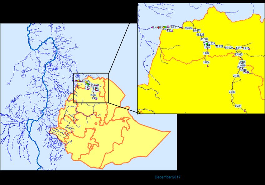
Preface This report is deliverable D26 of the Dutch Climate Solutions research programme. The programme acts as a platform for the Energy research Centre of the Netherlands (ECN) to support the Netherlands Directorate-General for International Cooperation (DGIS) in the realisation of Dutch policy objectives concerning poverty reduction and sustainable development. Support is delivered through the provision of demand-led, product-driven research and knowledge development. Particular attention is paid to expanding the contribution of Dutch expertise, innovation and technology to international climate assistance. The main question address within this programme is how to leverage climate and private sector investments for sustainable and climate smart development, for with the consideration of the water-energy-food nexus is key. Accordingly key research questions dealt with are: a) How do we create a sustainable and effective balance in the water, energy and food sectors to achieve the Sustainable Development Goals, in the face of climate change, and b) what is the role and potential of climate finance to bring about transformative change in developing countries? The program combines mutually reinforcing research and recommendations on the level of multilateral finance architecture, Dutch development aid and the Dutch climate technology sector to propose an integrated approach to support the climate technology sector and explore climate finance mechanisms through which the Dutch water-food-energy sectors can export their Climate Smart Solutions. The Dutch Climate Solutions programme is funded by the Netherlands Ministry of Foreign Affairs and implemented by a consortium coordinated by the ECN. The consortium comprises the following organisations: Energy research Centre of the Netherlands (ECN) Deltares Stichting DLO, Wageningen UR Duisenberg School of Finance (until 1 October 2015). The Dutch Climate Solutions programme is registered under ECN project number 5.2734. The sole responsibility for the content of this report lies with the authors. It does not represent the opinion of the Netherlands Ministry of Foreign Affairs, and the Ministry is not responsible for any use that may be made of the information contained herein. ECN-E--18-020 Page 3 of 67

Table of contents

Abbreviations                                                                                       5
Summary                                                                                             6
1.   Introduction                                                                                   8
     1.1       Background                                                                           8
     1.2       General and specific objectives of the study                                         9
     1.3       Description of stakeholders consulted and research methodology                      10
2.   Description of the case study area                                                            12
     2.1       Brief physical and social description of Humera woreda                              12
     2.2       Projected climate change                                                            17
     2.3       Current water, energy, food/land policy environment                                 17
3.   Analysis of the Nexus elements and development of integrated strategies for sustainable
     development of the region                                                               20
     3.1       The sesame value chain                                                              20
     3.2       The water sector – the Tezeke river basin in kafta Humera sub catchment             23
     3.3       The energy sector in Kafta Humera                                                   32
     3.4       Food security and sesame production potential                                       41
     3.5       Towards a Nexus Policy Strategy for sustainable development                         45
4.   Concluding                                                                                    53
     4.1       Conclusions                                                                         53
     4.2       The Nexus approach – what have we learnt in Humera woreda?                          55
     4.3       Nexus and climate finance                                                           56
Literature cited                                                                                   58
Persons consulted                                                                                  60
Annexes                                                                                            61

Page 4 of 67                                                                             ECN-E--18-020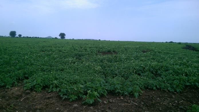
Abbreviations

CRGE            Climate Resilient Green Economy
CSA             Central Statistics Agency
ECN             Netherlands Energy Research Centre
GTP             Growth and Transformation Plan
SBN             Sesame Business network
IAIP            Integrated Agro-Industrial Park
LEAP            Long-range Energy Alternatives Planning system
MASL            Metres Above Sea level
Qtl             Quintal (100 kg)
RIBASIM         River Basin Simulation Model
WEF             Water, Energy, Food
WUR             Wageningen University & Research

ECN-E--18-020                                                    Page 5 of 67
Summary

The Nexus approach aims to analyse the linkages between the water, energy and food sectors and
especially the trade-offs (developing one sector at the expense of the other) and possible
synergies (innovative win-wins) between the sectors. The approach aims to break down the walls
that so often prompt the relevant ministries and organisations to focus on their mandates and
work in isolation from each other. Especially in the light of rapid population growth - as is the case
in Ethiopia - and uncertain climate change outcomes is it important to zoom in and interconnect
the three fundamental assets of people’s livelihoods: water, energy and food.

The approach was applied in Humera woreda in western Tigray in August 2017 to provide insights
as to how a nexus approach could work, how possible nexus solutions could be integrated into
government programmes and business strategies, and how a contribution could be made to
sustainable development of the economy of Humera woreda. The focus of the case study in
Humera was the emerging development of a large-scale Agro-industrial Park and its role in
potentially boosting sesame production in the area. The latter angle was analysed in close contact
with the Sesame Business Network (SBN) project that operates from Humera. A team from
Deltares, ECN and Wageningen University joined by SBN staff conducted the case study, and
reported its findings in a workshop for stakeholders in Mekelle in December 2017 and to the Royal
Dutch Embassy in Addis Ababa.

Applying a nexus approach proved to be very helpful in encouraging sectoral authorities to look
beyond their sector boundaries of policy and practice, and think through the implications of the
decisions they make. It was acknowledged that these specific sectors of water, energy and food
are indeed interrelated. In addition, the case study proved to be a valuable addition to the
feasibility study conducted for the Bae’ker Agro-industrial park in which the long term implications
of full production on energy, water and food consumption were not included. Different scenarios
for 2030 and 2050 were designed and evaluated.

In the case study three different models were applied: the LEAP model for the energy sector, the
RIBASIM model for the water sector, and the Water-limited yield model for the agricultural sector.
The models were run on the basis of collected data, for different scenarios and based on
assumptions that were tested with stakeholders. Generally speaking one can conclude that the
planned development of Bae’ker Industrial Park will not jeopardize sustainable development of
energy, water and food sectors in Kafta Humera. Resources are also sufficient to allow for the
envisaged expansion of the irrigation schemes, and to keep the projected increased population
food-secure. Apart from rampant deforestation and the projected depletion of wood resources in

Page 6 of 67                                                                               ECN-E--18-020

2034 with expected negative implications for water sources, soils and climate, the Nexus analysis
did not reveal any other trade-offs to be made between the water, energy and food sectors. The
expected shortage of wood (and therefore charcoal) will have to be covered in future by a
combination of investments in the forestry sector and related sustainable use of forests, more
efficient use of wood and transition to other energy sources such as electricity. This transition is
considered to be achievable.

Climate change predictions for Northern Ethiopia show a slight rainfall increase as well as a
temperature increase. In addition it is expected that the chances of extreme weather events will
increase. This can be extreme rainfall or extreme drought. One of the scenarios simulated
therefore was based on 1984 drought conditions. If such conditions reoccur in future, major water
shortages can be expected in Kafta Humera. The Tekeze river system is expected to yield too little
water to meet all demands from the growing population and industry.

In case of drought like the one of 1984 in which rainfall dropped to 50% of the normal, the
agricultural yields would also equally drop 50%. When combined with extreme high temperatures
                                                 . Most likely local food production will not be able
to sustain the population and preparation for such extreme events is key. The latter is an
important addition. In 1994 Ethiopia was still recovering from turbulent historic events. In 2018,
Ethiopia has a stable government and is believed to be capable of managing the impact of
droughts.

Overall, the Nexus analysis is good news for the sesame sector that aims to add value to primary
production: under average conditions there is sufficient land, water and energy potential in
Humera to fully develop a sesame agro-processing industry in the Bae’ker IAIP.

ECN-E--18-020                                                                              Page 7 of 67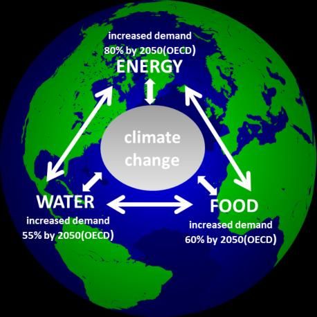
1. Introduction

1.1      Background
According to UN DESA1 the current world population of 7.3 billion is projected to reach 8.5 billion
by 2030, 9.7 billion in 2050 and 11.2 billion in 2100. Most of this increase is expected to be
concentrated in nine countries: India, Nigeria, Pakistan, the Democratic Republic of Congo,
Ethiopia, the United Republic of Tanzania, the United States of America, Indonesia and Uganda.
Based on these population trends and on rapid urbanization and rising living standards, it is
estimated that by 2050 global energy demand will increase by 80%, water demand by 55% and
food demand by 60%2. These trends are placing increasingly
competitive demands upon finite natural resources for
agriculture, energy and water. The effects of climate change
pose an additional challenge, as heavy flooding in coastal areas
and severe droughts in more arid regions could further
exacerbate this competition and seriously impede economic
growth.

So far, energy, food and water challenges have mainly been
addressed within the sectors concerned. This has resulted in
policies and interventions that focus primarily on individual
sectors, rather than considering the broader cross-sectoral
impact. This lack of coordination, dialogue and collaboration among sectors can significantly affect
the efficiency and effectiveness of policies and may also prevent appropriate measures from being
taken. So there is an urgent need to address these challenges simultaneously and develop an
integrated approach. Balancing the trade-offs between these sectors will be essential if we are to
achieve sustainable development and ensure water, energy and food security by maximising the
potential synergies and efficient solutions.

The growing need for integrated resources management thinking is what triggered the
development of the Water-Energy-Food (WEF) Nexus concept which stems from system analysis
and is centred around the many links that exist between the water, energy and food sectors.
Water, for example, is used in agricultural production processes and for cooling the waste heat
from power plants; energy is used for irrigation (pumping water), food production processes and

1
    UN DESA: World Population Prospects, the 2015 Revision
2
    OECD Environmental Outlook to 2050: The Consequences of Inaction-Key facts and figures.

Page 8 of 67                                                                                  ECN-E--18-020
power in agricultural machinery and tractors; and palm oil is used for cooking and is a key ingredient in food production, but it is also used to produce biofuel. Taking into account these links while designing policies to ensure long term water-food-energy supply security could result in more development using fewer natural resources. Nexus and the private sector The World Economic Forum, a private sector initiative, embraced the concept and argued that there are important links between water, food, energy and climate change. It has since published several books and articles on the issue, with many detailed figures about current and future use of resources and challenges to be faced (see Hoff, 2011). Business drivers for interest in nexus thinking are (Reynolds and Cranston, 2014): business stability (avoid scarcity resources and environmental damage caused by flood, drought, storm etc.), burden of future regulations in the market and reputation. To secure the involvement of the private sector, scale is needed, and investment in natural capital. Researching the applicability of the Nexus approach in Kafta Humera To research the usefulness of the Nexus approach one needs a geographical area for testing. The selection of the area was a rather pragmatic process. We needed an area where already contacts existed (‘feet on the ground’) and where there were possibly issues regarding food, energy and water. Through the BENEFIT programme, Wageningen University and Research has good contacts with ministries and agencies in Ethiopia. One of the components of BENEFIT is the Sesame Business Network (SBN). The staff of the SBN project showed interest in the nexus approach and this study has been conducted jointly. They suggested to focus on the Humera area in Tigray province. The area features extensive sesame production, and an industrial park that will be established to process agricultural products from the area. The establishment of this industrial park is an ambitious project and in combination with a considerable increase of the population in the area, it could have a serious impact on the availability of water, energy and food. This makes the industrial park an interesting focal point for applying a nexus approach. The case study research has been conducted by institutes from the Netherlands water sector (Deltares), the food sector (Wageningen University and Research) and the Netherlands energy sector (ECN) and is therefore well positioned to investigate the WEF Nexus and to contribute to the debate on long-term water, food and energy supply security challenges. The consortium was joined by the SBN project team to research the Humera case study in August 2017. 1.2 General and specific objectives of the study General objectives of the case study are: 1. Applying a nexus approach at local or sub-national level by providing insights into how possible nexus solutions can be integrated into government programmes and business strategies. 2. Contribute to the sustainable development and diversification of the economy of the Humera woreda, Ethiopia, by assessing - with stakeholder participation - the trade-offs and synergies between the Agriculture and Food sector at the one hand and the Water and Energy sectors at the other hand in the target area; and propose concrete actions. ECN-E--18-020 Page 9 of 67
Specific objectives are:
1. Assess the sesame value chain and proposals for adding value within Ethiopia, with a focus on
the implications for the long-term demand and supply of energy, water and food.
2. Assess future water and energy needs for the urban and rural populations, industrial and
agricultural activities.
3. Assess the future food requirements of Humera woreda vis-a-vis the expanding sesame
production and required need for water, energy and land.
4. Develop a strategy for sustainable development of the water, energy and food sectors in
Humera woreda taken into account the interdependencies between these sectors and the
changing weather patterns due to climate change.
5. Propose sustainable options to deliver the needed additional energy and water while securing
food for all.
1.3 Description of stakeholders consulted and research methodology
The following groups have been involved in the case study:
Governmental officials at central level (Addis Ababa)
Embassy of the Kingdom of the Netherlands in Addis Ababa
Government at Humera woreda level as well as Tigray State level
Farmers’ organisations and other relevant NGOs
Research organisations
Agro-industry in the selected area, if possible Dutch private sector working in selected area
BENEFIT project and most notably the Sesame Business network (SBN) project staff at national
scale and at the level of the selected area
Projects in the selected area working on water, climate and energy.
Methodology
The work in Ethiopia was executed during three missions to the target area and desk work in the
Netherlands:
3. Mission 1: Preparatory mission to the capital of Ethiopia, Addis Ababa, in order to familiarize
the Dutch Climate Solution team with the energy, water and food situation in the target area,
to collect data and to conduct reconnaissance interviews with representatives of ministries
and other stakeholders, including staff of the BENEFIT programme in Ethiopia and The
Netherlands;
4. Mission 2: visit to the target area to talk directly to stakeholders and collect relevant
information and data.
5. Desk work in the Netherlands to analyse the situation, to identify the trade-offs and possible
synergies and to assess possibilities for climate funding of proposed activities. Develop
(simplified) business cases to show the benefits and costs and how the solution could be
financed.
6. Mission 3: Capacity building and consultation workshop with stakeholders:
a. Presentation of the results of the first field mission and the desk analysis. A validation and
feedback workshop was organised in Mekelle on the 6th of December, 2017. In attendance
were staff from Tigray State Government, government departments at Humera Woreda
level and from the SBN Project;
b. Discussion and adaptation of the models that were developed for the three sectors, adapt
them to local needs and realities;
c. Presentation of a simulation game to the stakeholders; and
d. Discussion of results with the Royal Netherlands Embassy in Addis Ababa.
7. Preparation of final report.
Page 10 of 67 ECN-E--18-020Development of demand and supply scenarios for 2030 and 2050
The Nexus approach aims at analysing the linkages, the trade-offs and possible synergies between
the Water, Energy and Food sectors as explained above. For natural resource analysis and policy
development it is relevant to do so for today but especially for the future. This section aims to map
out the demand and supply of water, energy and food for 2030 and 2050 respectively. Because it
is impossible to predict the future we described four different scenarios:
0. The base line situation (current status of WEF use and production) in Kafta Humera
1. The reference scenario in 2030 and 2050. This scenario includes the development of
Bae’ker Integrated Agro-Industrial Park (IAIP), the projected population growth based on
20073 urban and rural population growth percentages, all policies such as the Growth and
Transformation Plan II and the Climate Resilient Green Economy implemented as planned,
the planned 20.000 ha irrigation schemes in the woreda, and the ongoing deforestation.
2. The “expanded irrigation scenario” in 2030/50. This scenario builds upon the reference
scenario but includes an additional 200.000 ha of irrigation to boost agricultural
production in the region.
3. The “Nexus policy Strategy” for 2030/50. For this scenario we have included typical nexus
policy measures such as a 100 MW solar power plant at Bae’ker, use of efficient cook
stoves, afforestation, solar powered irrigation, biofuel production, the construction of a
multi-purpose4 water reservoir in the Tekeze River. These options are ideas that are not
yet part of existing policies. A possible strategy is presented in section 3.5.
4. An “Extreme drought scenario”, analysing extreme climatic impact” (assuming another
1984 drought as part of the above 3 scenarios)5.
3
The data from the 2017 population census were not out at the time of writing this report.
4
Multi-purpose means storing water for generating electricity, for irrigation and drinking water supply.
5
Research in Ethiopia showed that droughts are likely to occur again, but this time it will probably not lead
to a famine as in 1984. Ethiopia has been very active on matters such as reforestation and soil and water
conservation. The land is now much less vulnerable for the occurrence of droughts. Source: Sil Lanckriet,
Amaury Frankl, Enyew Adgo, Piet Termonia, and Jan Nyssen. Droughts related to quasi-global
oscillations: a diagnostic teleconnection analysis in North Ethiopia. International Journal of Climatology,
2014.
ECN-E--18-020 Page 11 of 672. Description of the case
study area
2.1 Brief physical and social description of Humera woreda
Location, climate and population data
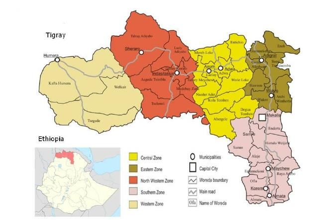
Kafta Humera (district or woreda) is located in north-western Ethiopia, in the western part of
Tigray Regional State, 991 km away from Addis Ababa. Kafta Humera borders the woredas
Tsegede and Wolkayte in the south (together they form Tigray western Zone) and with Sudan in
the west (see map). In the north, the Tekeze River (a tributary of the Nile) separates the district
from Eritrea. The district administrative centre is Humera town (Setit). The altitude range is 560-
1849 m.a.s.l. The district covers an area of around 7000 Km2. The area is part of a semi-arid agro-
climatic zone. The geological classifications of the district are mainly early tertiary volcanic and
Pre-Cambrian rocks. The dominant soil types are Chromic Eutric and Calcic Combisols; Chromic
and Orthic Luvisols and Chromic and Pellic Vertisols (EMA, 1988). The vegetation communities in
the districts include Acacia-Commiphora, Combretum-Terminalia and dry evergreen woodlands
(Eshete et al., 2011).
Figure 1 Map of Kafta Humera in Tigray State
Page 12 of 67 ECN-E--18-020Rainfall in the study area is generally characterized by low inter annual and seasonal variability.
The mean of rainfall is 540.6 and varies from 357.8mm and 650mm minimum and maximum
respectively. The median rainfall of the study area is 549.5mm annually and the coefficient of
variation of the annual rainfall was low (16.7 %) implying limited variability of rainfall. On average
the main rainy season (June –September) contributes 85% to the annual rainfall totals.
These figures are contradicted by other reports. The June 2015 “Agronomy Feasibility Report of
Tekeze Humera pump irrigation” report (page 4) for example states that data from the
metrological station located in Humera town show sixteen years (1996-2011) of annual rainfall
with an average of 1052.04mm. The SBN project estimates rainfall figures between 600 (min.) and
1000 mm (max) per annum. The mean minimum temperature ranges between 17.50C and 22.20C,
while, the mean maximum temperature varies between 33 and 41.7 0 Celsius. Mean monthly
evapotranspiration rate of the study area ranged between 141.6 in December and 200.7
mm/month in April. Source: Awetahegn Niguse et al (2015, page 24 – 26).
Population in the district has increased from 48,690 in 1994 to 92,144 in 2007 meaning a
population growth rate of 3.6% per year. According to CSA (1994, 2007), the majority of the
people (about 67%) are living in rural areas while about 33% are urban inhabitants. With these
2007 census figures the population density of the district is 14.56/km2, which is less than the zone
average of 28.9 and the national average 77.72. A total of 23,449 households were counted in this
district and the average household size was estimated to be 3.93 persons. The "food security and
vulnerability study in selected towns in Tigray (WFP, 2009) found an average household size to be
4.5. Tessema (p. 28) measured the average household size in Humera in 2007 as 4.2. Nega et al
(2010) measured an average household size for Humera (rural) of 4.72; and 4.98 for Humera
Town. For the analysis in this report it is proposed to stick to an average household size of 4.5.
Population growth was partly caused by natural growth but especially the result of resettlement
programmes over the past 30 years by government offering land to farmers originating from the
highlands.
Current population figures are not available (2017). The last population census is from 2007; the
2017 census has been conducted but confirmed figures will only be available in mid-2018. We
therefore estimate population figures for 2017, 2030 and 2050 by extrapolating the figures from
the 2007 census. The numbers are in the table 1a and table 1b below. The population numbers in
Humera woreda are expected to triple between 2017 and 2050.
Table 1a Estimated population increase Humera in 2030 and 2050 using geometric method (Sources: CSA 2007
Population census; Federal Democratic Republic of Ethiopia (August 2013))
2017 2030 2050
Rural Urban Total Rural Urban Total Rural Urban Total
Kafta Humera 68,574 50,321 118,895 71,112 91,049 162,161 75,202 226,711 301,913
Humera Town
36,074 36,074 65,271 65,271 162,524 162,524
Total 154,969 227,433 464,437
ECN-E--18-020 Page 13 of 67Table 1b Tigray population growth rate percentage based on CSA population projections 2008-2037 Urban 4.667 Rural 0.28 Land use and farming systems in Humera The land use system is characterized by a mixed farming system dominated by arable farming; and this includes cereals (31.24%), pulses (5.94%), oilseeds, predominantly sesame (60.87%) and vegetables (1.95%). The economy of the district is centred on the production of sesame, cotton and sorghum. Many farmers (69%) are practicing a mix of cereal-livestock farming, while 28% cultivates annual crops and 3% livestock rearing. Regarding land ownership and land distribution/holding about 75% of farmers possesses own land (meaning state leasehold), 25% is renting (CSA, 2007). "Land ownership" is mixed. One can largely differentiate between "investor farmers" and "small- scale farmers". In Humera over 500 large scale investor farmers cultivate lands over 50 hectares, some even over 600 hectares of sesame, while small scale farmers cultivate up to 3 hectares/household. It is estimated that in the district, investors cultivate 58% of the cultivated land while local farmers use the remaining 42% (KHDLR, 2007). The average land size per farming household in Humera is 6,23 Tsimad (around 1.5 hectare). The average land size is relatively big for Ethiopian standards because part of western Tigray was used as resettlement area in 2002/2003, and farmers were allocated 2 hectares per household (Abay, 2005; Tessema, 2007). In the whole of Tigray region every household possesses around two plots of land. In Kafta Humera however the average is 1.15 as indicated in the 2011 Tigray Baseline Socioeconomic Survey. “Big” land sizes, low population density and agricultural potential of the area explain why the three woredas (Kafta-Humera, Welkayte and Tsegede) in western Tigray are (in 2009) the only ones out of 34 in the region that are food secure (WPF/VAM, 2009). The main land use categories of Kafta Humera, and changes over a 25 year period, are below in table 2 (Binyam, 2012). Table 2 Areas of Land use and land change of Kafta Humera District for the Years 1985, 1995 and 2010 Land Use and land 1985 1995 2010 cover Area (ha) (%) Area (ha) (%) Area (ha) (%) Agricultural land 148,772.34 23.51 178,640.37 28.23 247,509 39.11 Bare land 27,832.68 4.40 28,433.61 4.49 33,796.62 5.34 Wood land 266,879.88 42.17 225,538.11 35.64 162,973.26 25.75 Shrub land 96,540.03 15.25 108,364.5 17.12 107,579.07 17.00 Grass land 92,158.29 14.56 914,09.94 14.44 80,667.99 12.75 Water body 694.53 0.11 491.22 0.08 351.81 0.06 Page 14 of 67 ECN-E--18-020
The most conspicuous trend is that agricultural land has expanded (+15.5% of total Humera land
area) while woodland has decreased with 16.4%. Table 3 shows that these trends have increased
after 1995.
Table 3 Rate of Changes in land use (1985-2010)
1985 to 1995 1995 to 2010
ha/year % per year ha/year % per year
Agricultural land 2986.80 2.01 4591.24 2.57
Bare land 60.09 0.22 357.53 1.26
Wood land -4134.18 -1.55 -4170.99 -1.85
Shrub land 1182.45 1.22 -52.36 -0.05
Grass land -74.84 -0.08 -716.13 -0.78
Water body -20.33 -2.93 -9.29 -1.89
The current land use is estimated as follows in table 4:
Table 4 The current land use (Source: 2013 baseline survey conducted by the SBN project)
2013 SBN baseline figures Kafta Humera
1 Cultivated land Ha 388,880
2 Forest land Ha 240,000
3 Grazing land Ha 36,800
4 Gdmagdmi Ha 28,142
5 Wasteland Ha 23,830
Total Ha 717,652
The same SBN Project base-line survey estimates the total arable land availability at 396,852
hectares meaning that the future agricultural expansion potential in the woreda is limited.
Deforestation
Northern Ethiopia in general and the Tigray Region in particular, is facing a severe woody biomass
shortage. An investigation of the fuel supply and demand behaviour of farm households in rural
Tigray showed that biomass fuels, especially woody biomass and dung cover about 96% of the
total fuel consumption in the Region. The daily per capita energy consumption was estimated
around 2kg in Humera by Tessema, 2007. Zenebe Gebreegziabher (WUR PhD thesis, 2007)
calculated the following figures for Tigray:
For rural households - Wood: 625 kg/yr/hsh and Charcoal: 2 kg/yr/hsh
For urban households - Wood: 1883 kg/yr/hsh and Charcoal: 542 kg/yr/hsh.
ECN-E--18-020 Page 15 of 67The latter figures are used in the models presented below. Nearly all the households and small
business (restaurants, coffee shops, small scale agro-processing) in Humera (Kafta and Setit) use
firewood, charcoal or dung as fuel. Converting forest land in agricultural land and sourcing
firewood goes hand in hand (Binyam, 2012, p. 77-78).
In Kafta Humera satellite imagery in 2000 (before resettlement) and 2007 (after resettlement) was
used to measure the degree of change in land use and cover related to settlement. The results of
this analysis showed a decrease in woodland by 25.8% and an increased in arable land by 21.8%,
and in 2011 after ten years arable land increased almost by 100%, woody vegetation cover
reduced by 42% (Moti et al., 2011).
The figures from the various sources are not completely consistent. However the trend is clear:
there is expansion of agricultural land at the expense of woodland. This is summarized in table 5
which shows that in 2013 240,000 ha of woodland was left in Kafta Humera.
Table 5 Summary of Deforestation and annual change in Kafta Humera (Source: Binyam (2012), SBN project Baseline
Survey 2013)
1985 1995 % /year 2010 %/year 2013
Woodland 266879 225538 -1.55 162973 -1.85
Shrubland 96540 108364 1.22 107579 -0.05
Total 363419 333902 270552 240000
Livestock production system
Next to crop production also animal rearing is a main income generating system. Cattle population
in the study area is currently estimated to be 51,369 heads. Goat population is estimated to be
19,245; sheep population 11,152, and equine (only donkey) 5083 heads. The major feed resource
in the area is forage obtained from the rangelands. Almost the total area of the Kafta-Humera
woreda excluding the cultivated land by commercial and smallholder farmers is rangeland. It
covers about 43% of the total land of the woreda. Crop residues from sesame, sorghum and others
are also a good source of animal feed (Kidane, 2011).
Table 6 Summary of Deforestation and annual change in Kafta Humera (Source: Binyam (2012), SBN project Baseline
Survey 2013)
1985 1995 % /year 2010 %/year 2013
Woodland 266879 225538 -1.55 162973 -1.85
Shrubland 96540 108364 1.22 107579 -0.05
Total 363419 333902 270552 240000
Page 16 of 67 ECN-E--18-020Livestock production system Next to crop production also animal rearing is a main income generating system. Cattle population in the study area is currently estimated to be 51,369 heads. Goat population is estimated to be 19,245; sheep population 11,152, and equine (only donkey) 5083 heads. The major feed resource in the area is forage obtained from the rangelands. Almost the total area of the Kafta-Humera woreda excluding the cultivated land by commercial and smallholder farmers is rangeland. It covers about 43% of the total land of the woreda. Crop residues from sesame, sorghum and others are also a good source of animal feed (Kidane, 2011). 2.2 Projected climate change This section draws upon two sources: the 2015 MER report on Ethiopia’s Climate Change Profile, and the Government of Ethiopia’s strategy paper on Climate Resilient Green Economy. Climate change projections are impossible to generalise for the whole country that consists of very diverse agro-ecological zones. Still, generally speaking the country is expected to face increasingly unpredictable rains, and increased variability of seasons. The lowlands are vulnerable to increased temperatures and prolonged droughts which may affect livestock rearing. The highlands may suffer from more intense and irregular rainfall, leading to erosion, which together with higher temperatures leads to lower total agricultural production. This, combined with an increasing population, may lead to greater food insecurity in some areas. In Humera the average temperature is expected to increase with 1 degree in 2030 and another degree in 2050; rainfall will increase slightly but especially rainfall variability and seasonal variability are likely to change. This makes rainfall less predictable, and means higher chances of heavy precipitation during the rainy season, and can lead to extreme events (flooding, storms, dry spells) (MER report, page 4). For Humera this could mean that fragile crops such as sesame can be seriously affected, and that extreme rainfall or extreme drought can lead to soil erosion especially after concluding that deforestation in the Humera area is very serious. Extreme events are estimated to reduce total GDP by 1% to 4%. Soil erosion has been estimated to reduce agricultural GDP by 2% to 3% (around 1% of total GDP) (CRGE, page 5). The above climate change projections are included in all scenarios that are presented in this study. 2.3 Current water, energy, food/land policy environment There are a number of policy documents that are relevant for the Humera Nexus case study: Second Growth and Transformation Plan (GTP II) 2015/16-2019/20 In general, during the period of the second Growth and Transformation Plan on Agriculture, objectives are set to further enhance the benefit of citizens that would receive from the fast and sustained growth, ensure structural transformation within the sector and across the overall economy and build agricultural production capacity. The major agriculture and rural transformation targets of GTP II are broadly set in terms of increasing crop and livestock production and productivity, promoting natural resource conservation and utilization, ensuring food security and disaster prevention and preparedness: ECN-E--18-020 Page 17 of 67
1. Increasing Crop Productivity and Production: the crop subsector constitutes the major
       share of agricultural GDP. Accordingly, increasing the production and productivity of major
       crops will continue to be a priority in the next five years so as to maintain the fast and
       sustained growth achieved during the last decade. In this regard, improving the supply and
       application of agricultural inputs and effectiveness of agricultural extension services will
       be given due priority. Establishing effective agricultural marketing systems through
       forming and strengthening cooperatives will also be an important priority area. The
       participation of the private sector in this endeavour will be encouraged and supported as
       well.
    2. Increasing Livestock Productivity and Production: The productivity of the livestock sub
       sector has been at its low during the implementation of the first Growth and
       Transformation Plan (2010/11-2014/15). Special emphasis will be given to the livestock
       subsector with the objective of adequately exploiting its potential for growth, export
       earnings and job creation. The strategies set to realize these objectives are: improving
       animal health, animal feed and animal breed with targets to increase the productivity of
       meat, milk, honey and eggs.
    3. Natural Resource Conservation and Utilization: During the first Growth and
       Transformation plan, remarkable achievements have been made in terms of natural
       resource conservation and utilization. Hence, scaling-up this strategy will be a priority. In
       this regard, expanding small-scale irrigation in tandem with natural resource conservation
       to increase agricultural productivity and production would help enhance the economic
       contribution of natural resources.
    4. Food security, disaster prevention and preparedness: The governments is committed to
       ensuring food security and strengthen the capacity of disaster prevention and
       preparedness by increasing agricultural productivity and production and implementing
       other safety net and risk reduction programs.

As part of the Growth and Transformation Plan (GTP), the Ministry of Industry and Ministry of
Agriculture planned to establish 4 Integrated Agro-Industrial Parks (IAIPs) in the near future. One
of them is located in Humera woreda (35 km south of Humera Town), in Bae’ker. The objectives of
establishing this park is to boost agricultural business development, to attract private investment
in food processing and create jobs and rapid rural economic growth (Federal Democratic Republic
of Ethiopia, 2015, page 3). The production area expected to supply the IAIP with raw material
covers not only Humera but the entire Western and North-western Tigray sub-regions.

GTP II also promote irrigation to ensure sustainable food production systems and implement
resilient agricultural practices that increase productivity and production, that help maintain
ecosystems, that strengthen capacity for adaptation to climate change, extreme weather, drought,
flooding and other disasters and that progressively improve land and soil quality.

In GTP II efforts will be made to increase forest contribution to the economy and ecology, through
sustainable forest development and conservation activities. More specifically through initiating the
identification, demarcation, registration and protection of forest resources and also undertaking
research-based forestry development.

Page 18 of 67                                                                           ECN-E--18-020
Water in GTP II
With regard to water and sanitation, according to the GTP I standard, it is planned to increase
access to clean water from 84% in 2014/15 to 100% at national level during GTP II period. On the
other hand, rural water supply coverage (GTP II standard of 25 l/c/d within 1km radius) will
increase from 59% in 2014/15 to 85% by 2019/20. Similarly, urban water supply (based on the
ranking of the demand: 100, 80, 60 , 50 and 40 litres/person /day from first to fifth level towns,
respectively) access to clean water is planned to increase from 51% to 75%.
Accordingly, national water supply coverage is planned to increase from 58% to 83% in the same
period. In addition, dysfunctional rural water supply systems will be reduced from 11.2% to 7%
and Urban Fault Waters (UFW) is planned to decrease from 39% to 20% in the plan period. Ground
water exploration coverage will increase from 13% to 25% during the same period.
The Climate Resilient Green Economy (CRGE)
The CRGE vision is a zero net carbon economy by 2025, and the ambition is to generate all
electricity from renewable energy resources with up to 20% wind and solar, 10% geothermal and
70% hydropower.
The Green Economy (GE) Strategy sets out the plans for developing a low carbon economy in
Ethiopia. Detailed analysis showed that GHG emissions in Ethiopia would rise from 150 MtCO2e
per year in 2010 to 400 MtCO2e in 2030 under a conventional development path (‘business as
usual’ scenario). The GE Strategy identified and prioritised more than 60 initiatives, which together
enable the country to achieve the development goals while limiting GHG emissions in 2030 to
today’s levels. These initiatives would save 250 MtCO2e per year with around 90% of low-carbon
development opportunities coming from the Agriculture and Forestry sectors. For more than 80%
of the options, the ‘abatement cost’ was less than $15 t/CO2e. These options can be seen as ‘no
and low regrets’ offering positive return on investments and therefore directly enhancing
economic growth. Continued planning and implementation will make Ethiopia’s middle-income
economy carbon neutral.
The GE Strategy is built on four pillars, these are:
1. Improving crop and livestock production practices for higher food security and farmer
income while reducing emissions (agricultural and land use efficiency measures).
2. Protecting and re-establishing forests for their economic and ecosystem services, including
as carbon stocks (increased GHG sequestration in forestry).
3. Expanding electricity generation from renewable sources of energy for domestic and
regional markets.
4. Leapfrogging to modern and energy-efficient technologies in transport, industry, and
buildings (CRGE, page 10).
ECN-E--18-020 Page 19 of 673. Analysis of the Nexus
elements and development
of integrated strategies for
sustainable development
of the region
3.1 The sesame value chain
3.1.1 Sesame production in Kafta Humera
Kafta Humera is a prime sesame production
area in Ethiopia6. Around 30% of the national
production originates from Humera. The cash
crop is produced during the rainy season (June-
October) and is predominantly (95%) exported
in raw form to China, Israel, Turkey and USA.
The main end products in these countries are
sesame oil and tahini. Production is done partly
by smallholders - around 25.000 households (Hagose, 2017, p.3) - and around 500 investor
farmers. The latter own (read: lease from the State at soft terms) land ranging from 50 - >600
hectares. Smallholders typically own less than 3 hectares. Yield levels are relatively low with an
average of 559 KG/hectare (see table 7):
6
Information in this section is obtained from the SBN Project.
Page 20 of 67 ECN-E--18-020Table 7 Sesame production in Kafta Humera 2007-2016 (Source: SBN Project)
Cultivated land Total production Productivity per
Year
(ha) in qtl. hectare in qtl
2007 203,270.00 998,071.00 4.91
2008 223,918.00 1,403,548.00 6.27
2009 226,788.00 1,428,956.00 6.30
2010 264,657.00 2,143,722,00 8.10
2011 253,099.00 1,792,110.00 7.08
2012 248,068.50 881,553.00 3.55
2013 217,094.25 1,160,038.00 5.34
2014 240,324.00 962,087.00 4.00
2015 180,369.00 667,636.00 3.70
2016 205,113.00 1,355,192.00 6.61
Average 226,270.08 1,279,291.30 5.59
*Note: 1 quintal – qtl = 100 kg
Reasons for low production are manifold:
1. Sesame is a crop sensitive to weather conditions (water logging, droughts, winds during
harvesting). Two out of 5 harvests are considered reasonable, mainly due to favourable
weather;
2. Poor agronomic practices (little rotation practiced, poor pest&disease control, poor
fertilizer regimes);
3. Use of poor seed varieties;
4. Little mechanization, and poor harvesting practice and storage resulting in high post-
harvest losses (sometimes 30%);
5. Poor market infrastructure and low market prices for farmers due to a range of reasons
such as poor farmer organisation, power of traders and brokers, poor financial position of
farmers forcing them to see when prices are low, etc.; and
6. Absence of sesame processing facilities in the region keep prices low and do not provide
an incentive for investments in farmers in order to increase production.
The economic loss of low yields is substantial. With a potential to double the yield to 1.2 ton/ha
and a price of 40,000 ETB/ton, this loss may amount to 127,929x30,000= 5.1 billion ETB (117
million Euro).
3.1.2 The IAIP in Bae’ker and its consequences for water, sesame and population
As part of the Growth and Transformation Plan (GTP), the Ministry of Industry and Ministry of
Agriculture has started with the construction of Bae’ker Integrated Agro-Industrial park (IAIP) 35
kms south of Humera Town. The objectives of establishing this park is to boost agricultural
business development, to attract private investment in food processing and create jobs and rapid
ECN-E--18-020 Page 21 of 67rural economic growth. The production area expected to supply the IAIP with raw material covers
not only Humera but the entire Western and North-western Tigray sub-regions. However, impact
will be biggest in Humera: the demand for water; the demand for energy, the influx of labour, and
the increased demand for raw material (sesame, sorghum, fruits and vegetables, honey, dairy,
meat and other animal products) that necessitates an increase of production as and when the IAIP
of 150 hectares big is in full operation in 2026.
Projected water requirements (predominantly from ground water and tapping it from a nearby
seasonal stream): 6,777 cum/day. (IAIP Feasibility report, 2015, page 159). Projected power
demand: 45.47 MVA (taken from the power station in Humera). (IAIP Feasibility report, 2015, page
166).
The production requirements for the IAIP to become in full operation are substantial especially for
sesame, the main crop in the region (IAIP Feasibility report, p. 121). See table 8 which gives figures
for Humera woreda and for West Tigray, which contains apart from Humera, two other woredas.
Table 8 Production of main agricultural products in MPTA in Humera woreda and West Tigray (3 woredas) (Source: IAIP
Feasibility Report, 2015; production figures from the Agricultural Bureau, Humera)
2015 Production 2016 Production Required by
IAIP
Humera West Tigray Humera West Tigray
Sorghum 451,287 662,988 461,377 659,987 61,602
Sesame 66,763 98,598 135,519 178,132 245,645
* Note: MTPA = Metric Tonnes per Annum
With an average yield level of sesame of 559 kg/ha and an average annual production of 127.929
tons over the past 10 years it means that the amount of land under sesame in western Tigray and
most likely in Humera has to double to meet IAIP demand. This does not seem to be a wise option:
suitable land is not available anymore; increased sesame production will be at the expense of food
production, and deforestation will be enormous with negative impact on soils and climate.
Increased production to meet IAIP demand has to come from improved production technology
(such as irrigation, mechanisation, disease control, fertilisation, improve agronomic practices) in
the sesame sector resulting in a doubling of yields.
The IAIP is projected to provide employment for 779.000 people (IAIP Feasibility report, 2015,
page 343). This staggering amount does not only include people directly employed in the industrial
park (109.000) but also those employed in the surrounding rural areas (a radius of 30 km) that
produce the raw material (410.000). It is assumed that this number includes the seasonal labour
force that annually comes from the highlands to assist in growing sesame. The estimated indirect
employment (260.000) is generated in primary, secondary and tertiary sectors including banks,
logistics, insurance, trading, brokerage, etc.
Page 22 of 67 ECN-E--18-020Table 9 Projected employment at Bae’ker IAIP in 2026 (Source: Bae’ker IAIP Feasibility study (undated/not published)
Persons employed Assumed external origin
Direct employment at IAIP 109,147 54,574
Employment generated at RDC level 4,617 2,309
Additional employment generated in the Agro
405,774 202,887
Commodities Procurement Zone (ACPZ)
Total estimated direct employment 519,538 259,769
Estimated indirect employment 259,769 129,885
Total estimated employment 779,307 389,654
* Note: an assumed 25% of projected employment comes from beyond West Tigray – to be added to
projected population growth of the zone in 2030 and 2050.
Our assumption is that 50% of these projected employment numbers (400.000) originate from
Kafta Humera. 25% (200.000) are assumed to be seasonal labourers who will only marginally affect
water and energy consumption. 25% (200.000) of the employees are expected to migrate into
Humera and take up residency. This number has added to the projected population growth in
2030 and 2050 which therefore will change as follows:
Table 10 Estimated population increase due to Bae’ker IAIP influx
2017 2030 2050
Rural Urban Total Rural Urban Total Rural Urban Total
Kafta
68,574 50,321 118,895 71,112 291,049 362,161 75,202 426,711 501,913
Humera
Humera 36,074 36,074 65,271 65,271 162,524 162,524
Town
Total 154,969 427,433 664,437
These figures show that when we include an expected influx of employees to work at Bae’ker IAIP,
the population numbers in Humera woreda are expected to quadruple between 2017 and 2050.
3.2 The water sector – the Tezeke river basin in kafta Humera sub
catchment
The total annual volume of water flowing from the Tekeze basin is about 7.36 million m3 with a
peak flow rate in July and August. However, due to topographic positions, it has been challenging
to use a substantial amount of this volume of water. The streambed is 20 - 100m below the
potential arable land; consequently, the river water has been inaccessible unless an expensive
water lifting mechanism is introduced.
ECN-E--18-020 Page 23 of 67Additionally, due to seasonal inflow variation from the tributaries of Tekeze, the river has a
minimal flow rate during the remaining period of the year (September – June)7. Despite these
challenges, Tekeze river basin has the potential to provide a sufficient amount of water for
different purposes.
The current water demand in Humera is mostly covered by ground water, although the potential
has not been thoroughly prospected. This potential is believed to be very limited. To some extent,
water for Humera area is drawn from the Tekeze River and distributed in bags on donkeys.
However, the water from these surface sources is heavily contaminated with resulting health
issues. A supply of clean drinking water for Humera and its nearby farms would do much to
improve general health8.
3.2.1 Assessment of current water demand – the baseline situation
Domestic water supply for Kafta Humera and Humera town is mostly provided from ground water.
On the other hand, the irrigation water demand for the 2000ha pilot irrigation area in Kafta
Humera is supplied from Tekeze River. Based on the current urban and rural population in Kafta
Humera and Humera town, the total water demand is computed and presented in Table 11 and
Table 12 respectively. 20 l/cap/day for urban and 16 l/cap/day9 for rural areas are considered to
estimate the total demand10. DMI (Domestic Municipal and Industrial) demand incorporates all the
demand in the urban setting. Referring to the project report of Humera and nearby towns’ water
supply detail design main report, other urban demand is also included.
Table 11 Kafta Humera current (2017) water demand and supply analysis using RIBASIM
Kafta Humera 2017
Rural Population 68574
Urban Population 50321
3
Rural demand (m /day) 1156
3
Urban demand (m /day) 1007
3
Total Population demand water supply (m /day) 2163
3
Other Urban demand (m /day) 3854
3
Total demand (m /day) 6017
3
Water supply GW (m /day) 6017
Drinking Water Supply Deficit (m3/day) 0.00
Irrigation (ha) 2000
3
Irrigation (m /ha) 6000
3
Irrigation from Tekeze (m ) 12,000,000
7
http://www.iwmi.cgiar.org/assessment/files/pdf/publications/WorkshopPapers/DesignPerformance_Ka-
hsay.pdf
8
http://documents.banquemondiale.org/curated/fr/115661468275709895/pdf/multi-page.pdf
9
We note that GTP II mentions a planned 25 litre per person per day but we decided to keep our
estimated consumption low.
10
file:///D:/Project/Collaborative%20modelling/120987004/Mission%20doc/Urban%20Water%20Supply
%20Universal%20Access%20Plan.pdf
Page 24 of 67 ECN-E--18-020Table 12 Humera Town current (2017) water demand and supply analysis
Humera Town 2017
Urban Population 36074
3
Urban demand (m /day) 721
3
Other demand (m /day) 518
3
Total demand (m /day) 1239
3
Water supply GW (m /day) 1239
3
Deficit (m ) 0.00
3.2.2 Water demand scenarios for 2030 and 2050
In order to fully analyse and investigate the availability of water in Kafta Humera, various scenarios
are considered (see chapter 1): the reference scenario for both 2030 & 2050, the expanded
irrigation scenario, the Nexus policy strategy measures and Extreme drought scenario. The
reference scenario and expanded irrigation scenario are first investigated by only looking at the
available ground water resources in the area. As the results show significant deficits, the Nexus
policy measures are applied for each of these scenarios and simulated in the RIBASIM model using
the hydrological conditions of Tekeze River Basin. The Tekeze river basin is part of the existing
regional model (Nile Basin Model); also this model is built on RIBASIM11.
All the existing demands and proposed demands are included in the model in Figure 2.
11
RIBASIM (River Basin Simulation Model) is a generic model package developed by Deltares for analysing
the behaviour of river basins under various hydrological conditions. The model package is a
comprehensive and flexible tool which links the hydrological water inputs at various locations with the
specific water-users in the basin. For more information: https://www.deltares.nl/en/software/ribasim/
ECN-E--18-020 Page 25 of 67Figure 2 RIBASIM model schematization of Tekeze river basin in Western Tigray
The reference scenario
Element 1: A scenario based on the geometric population projections 2030, 20,000 ha
irrigated area and including the industrial park permanent 200,000 employee settling in
Kafta Humera.
Element 2: A scenario based on the geometric population projections 2050, 20,000 ha
irrigated area and including the industrial park permanent 200,000 employee settling in
Kafta Humera.
There are three important assumptions made:
1. We assume that the water needs of current population and current developments in
Humera are covered by ground water supplies, and that these supplies are recharged
annually.
2. We take along the assumption from the Bae’ker Feasibility study that the water demand
by Bae’ker IAIP is also covered by ground water.
3. We assume that current ground water extraction is at its maximum. In the absence of
ground water studies we cannot assume otherwise. To conduct a ground water study in
Humera would be a wise investment considering the planned developments, and expected
population growth
The additional demand due to population growth and various developments in 2030 and 2050 will
be added to the total demand of the respective year. The demand that exceeds the ground water
supply is considered as the deficit. Tables 13, 14 and 15 show the calculated demand, supply and
deficit for Kafta Humera, Bae’ker industrial park and Humera Town.
In 2030, the industrial park becomes fully functional, and 20,000ha of irrigation will be used for
agricultural production with 600mm of water as crop water requirement in a 3 month of growing
Page 26 of 67 ECN-E--18-020season. For Kafta Humera, domestic drinking water and irrigation water demands are included.
The resulting demand, supply and deficit is presented in Table 13.
Table 13 Kafta Humera water demand, supply and deficit in 2030 & 2050
Kafta Humera 2030 2050
Rural Population 71112 75202
Urban Population 91049 226711
3
Rural demand (m /day) 1199 1268
3
Urban demand (m /day) 1821 4534
3
Total Population demand water supply (m /day) 3019 5081
3
Other Urban demand (m /day) 7518 17635
3
Total demand (m /day) 10537 40351
3
Water supply GW (m /day) 6017 6017
3
Drinking Water Supply Deficit (m /day) 4521 34334
irrigation (ha) 20,000 20,000
3
irrigation (m /ha) 6000 6000
3
Deficit for Irrigation (m ) 120,000,000 120,000,000
According to the feasibility study, all demand from the industry (6777 m3/d) is planned to be fully
supplied from ground water source. Assuming there is a sustainable ground water supply, the only
water deficit will be the demand that is from the extra 200,000 permanent employees coming
outside the region. 20 l/cap/day is used to compute the demand of the permanent employees. The
resulting water demand, supply and deficit is presented in Table 14.
Table 14 Bae’ker industrial park water demand, supply and deficit in 2030 & 2050
Bae’ker industrial park 2030 2050
3
Demand (m /day) of the industry 6777 6777
External employees 200000 200000
3
Demand (m /day) from external employees 4000 4000
3
Total demand (m /day) 10777 10777
3
Water supply GW (m /day) 6777 6777
3
Deficit (m /day) 4000 4000
ECN-E--18-020 Page 27 of 67You can also read