REPORT TO THE KURRAJONG HEIGHTS COMMUNITY - Prepared by Brian Williams Captain & Gary Jol Senior Deputy Captain - Volunteer Fire ...
←
→
Page content transcription
If your browser does not render page correctly, please read the page content below
REPORT TO THE
                                             KURRAJONG HEIGHTS
                                                COMMUNITY
           Prepared by
     Brian Williams Captain
                &
 Gary Jol Senior Deputy Captain

Photo credit: https://maps.six.nsw.gov.au/

MARCH 2020                                   KURRAJONG HEIGHTS RFS BRIGADE REPORT TO COMMUNITY   1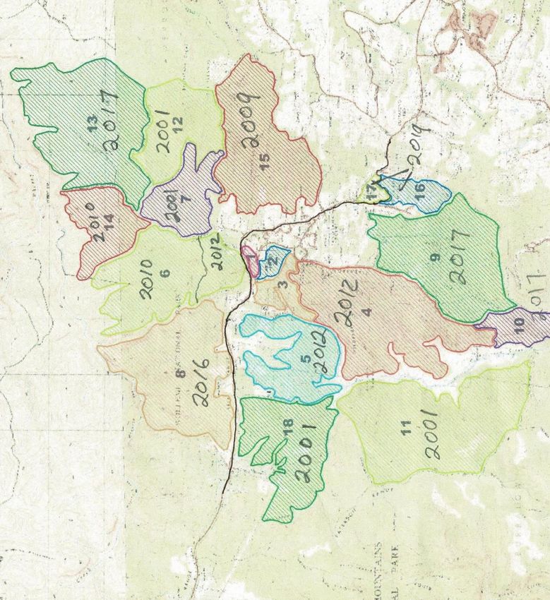
CONTENTS
   • Introduction
        •    Meet the team; Brigade activities
        •    Fire science explained
        •    Kurrajong Heights environment
   • Background & History
        •    The early days
        •    The Mosaic Approach
        •    Major Fires History
   • 2019
        •    Preparation – around the village
        •    Preparation – National Parks
        •    Gospers Mountain Fire
        •    Backburning operations
   • 2020
        •    Backburning operations
        •    KH Brigade Summary
        •    Current status
   • Frequently Asked Questions                               Photo credit: Kurrajong Heights RFS Facebook page

        •    How are Hazard Reductions approved?
        •    What is Aboriginal burning?
        •    Do Large Air Tankers help?
        •    Does HR increase CO2 levels?
        •    What’s next? Actions ….

MARCH 2020                                KURRAJONG HEIGHTS RFS BRIGADE REPORT TO COMMUNITY                       2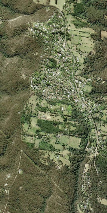
INTRODUCTION

                                         MEET THE TEAM

                                                                                                           Photo credit: Jeremy Braithwaite
                                                              Photo credit: Jeremy Braithwaite

   • The Kurrajong Heights Brigade is a small but            • We respond to situations at Kurrajong Heights,
     dedicated team                                            around the Hawkesbury, around the state and
        • For a small team we have large range of              interstate
          skills, experience and knowledge                   • Most of our members are long serving, with
   • Our roles include:                                        some members dedicating more than 50 years
        •    Fire ground fire fighting and prevention          service to the community
        •    Command and control positions
                                                             • Every member of the brigade is a volunteer
        •    Logistics
        •    Communication                                     who receives no financial reward
        •    Air observer                                    • Our Facebook page is
        •    Remote area fire fighting (RAFT)                     https://www.facebook.com/KurrajongHeightsRFS

MARCH 2020                           KURRAJONG HEIGHTS RFS BRIGADE REPORT TO COMMUNITY                                                        3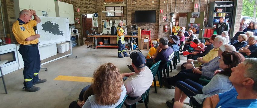
INTRODUCTION

                              BRIGADE ACTIVITIES
   • Issue permits
   • Emergency response
        •    Bush fires
        •    Structure fires
        •    Motor vehicle crashes
        •    Search and rescue                                Photo credit: Kurrajong Heights RFS             Photo credit: Kurrajong Heights RFS

        •    Ambulance assist                                 Facebook page                                   Facebook page

                                                                         Head on crash on Bellbird Hill
        •    Storm damage
   • Training
        • Essential basic and advanced fire
          skills and qualifications
        • Truck licence
        • Cadet training
        • Recertifications
   • Hazard Reduction & Fire Fighting
                                                               Photo credit: Kurrajong Heights RFS Facebook page

MARCH 2020                     KURRAJONG HEIGHTS RFS BRIGADE REPORT TO COMMUNITY                                                                    4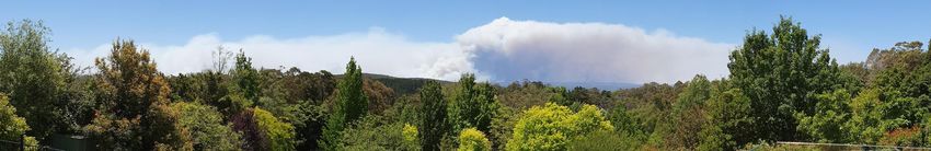
INTRODUCTION

                      FIRE SCIENCE EXPLAINED/1
   • Fuel load increases by 2 tonnes
     per hectare per annum. The fire
     intensity grows exponentially
        • After 10 years the unmanaged fuel
          load will be 20 tonnes per hectare
          and will have a fire intensity of
          4,000 kW/m2
        • Each kW is the same as a 1 bar
          radiator
        • 2,000kW/m2 is the maximum that
          can be tackled by fire brigade
          tankers. 4,000 is the maximum by             * https://www.dfes.wa.gov.au/safetyinformation/fire/bushfire/BushfireInfoNotesPublications/DFES-InfoNote-ForestFuelLoadsinUrbanInterface.pdf
          any man using any device i.e. LAT
   • Some recent fires have registered                                                                                           Fires run on a combination of
     an intensity of 100,000 kW                                                                                                  oxygen, heat & fuel

                                                                                                                                 Reduce the fuel = reduce the
   People burn the fuel or the fuel burns the people                                                                             fire

MARCH 2020                      KURRAJONG HEIGHTS RFS BRIGADE REPORT TO COMMUNITY                                                                                                                     5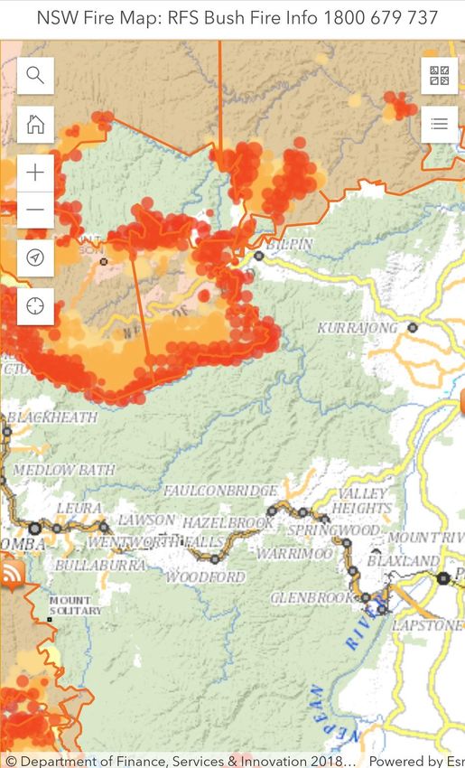
INTRODUCTION

                      FIRE SCIENCE EXPLAINED/2
   • Hazard Reduction (HR) burns are
     a ‘cold fire’
        • Leaves gullies unburnt as retreat
          areas for animals
        • Hollow logs retained & recolonised
        • Koalas just run up the trees & are
          safe
   • Wild fires over country with no                   Photo credit: Jeremy Braithwaite

     hazard reduction are ‘hot fires’
                                                                 This is taken from the lookout at Burralow Rd in
        • Every living thing is destroyed                            mid-January following the back burn on
        • Complete silence after a fire                           December 22nd. It was a cold fire and all the
                                                                             leaves are still on the trees
        • Soil runs off with the first rain
             • Chokes creeks and gullies                             It could be safely burnt thanks to HR in 2012
             • Kills the fish
                                                                  The window for HR is not narrow and ideal
        • May take 100 years to recover
                                                                conditions usually exist for 4+ months every year

MARCH 2020                     KURRAJONG HEIGHTS RFS BRIGADE REPORT TO COMMUNITY                                     6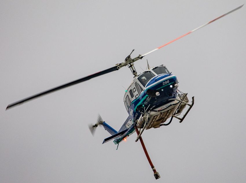
INTRODUCTION

             KURRAJONG HEIGHTS ENVIRONMENT
   • We’re in the worst possible
     environment to defend
        • Surrounded by bush on 4 sides
        • Top of a mountain … for every 10
          degrees of slope the fire doubles in
          speed and the intensity quadruples

   • Hawkesbury BFMC* covers
        • 2793 square kilometres
        • Windsor in the south
        • Berambing in the west
        • 80km north of Windsor on the Putty
          Road
        • East to the Old Great North Road

   * Bush Fire Management Committee
                                                                      3D Map of Kurrajong Heights

MARCH 2020                   KURRAJONG HEIGHTS RFS BRIGADE REPORT TO COMMUNITY                      7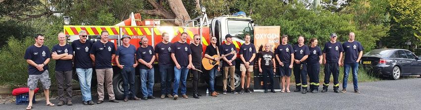
BACKGROUND & HISTORY

                            THE EARLY DAYS/1
   • Brigade established 68 years ago
        • Small number of families on the
          mountain
        • Everyone pitched in
        • Hazard reduction was a walk on a
          Sunday afternoon with a box of wax
          matches
   • First fire engine was Land Rover
     ute                                                    Photo credit: Kurrajong Heights RFS Facebook page

        • Still in the fire shed
        • Some knapsacks and flat shovels
   • Shed opening in 2004
        • Many members still with us
   • Never lost a house on the
     mountain

                                                            Photo credit: Kurrajong Heights RFS Facebook page

MARCH 2020                  KURRAJONG HEIGHTS RFS BRIGADE REPORT TO COMMUNITY                                   8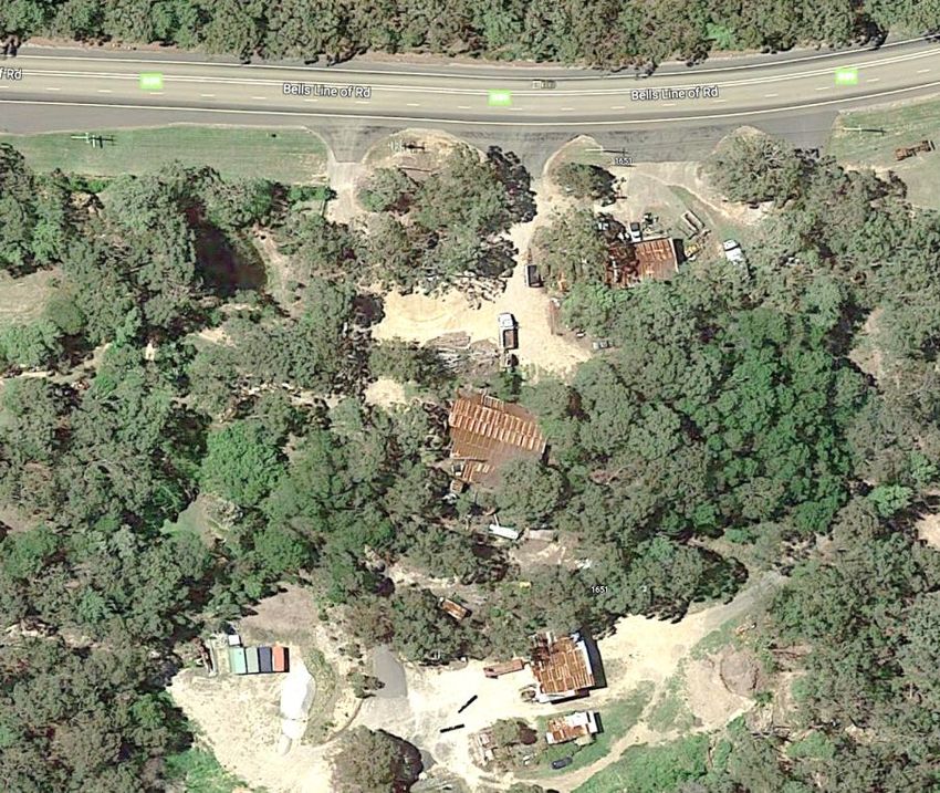
BACKGROUND & HISTORY

                             THE EARLY DAYS/2
   • Prior to the 1990’s much of the
     hazard reduction work was
     conducted by loggers like the
     Bucketts:
        • They logged up to 90km from the mill
        • They’d put in all the tracks we’d use for
          fire trails
        • They logged selectively and would thin
          the forests and do hazard reduction
        • All at zero cost to the community
   • Stock were grazed through the area
   • By the end of the 1990’s most of the
     Crown Land and State Forests had
                                                            Photo credit: Google Maps

     been turned into National Parks                                           The Buckett family mill on
        • The logging and grazing have stopped                                     Bells Line of Road
        • From this time the fuel loads have
          grown and grown and grown

MARCH 2020                    KURRAJONG HEIGHTS RFS BRIGADE REPORT TO COMMUNITY                             9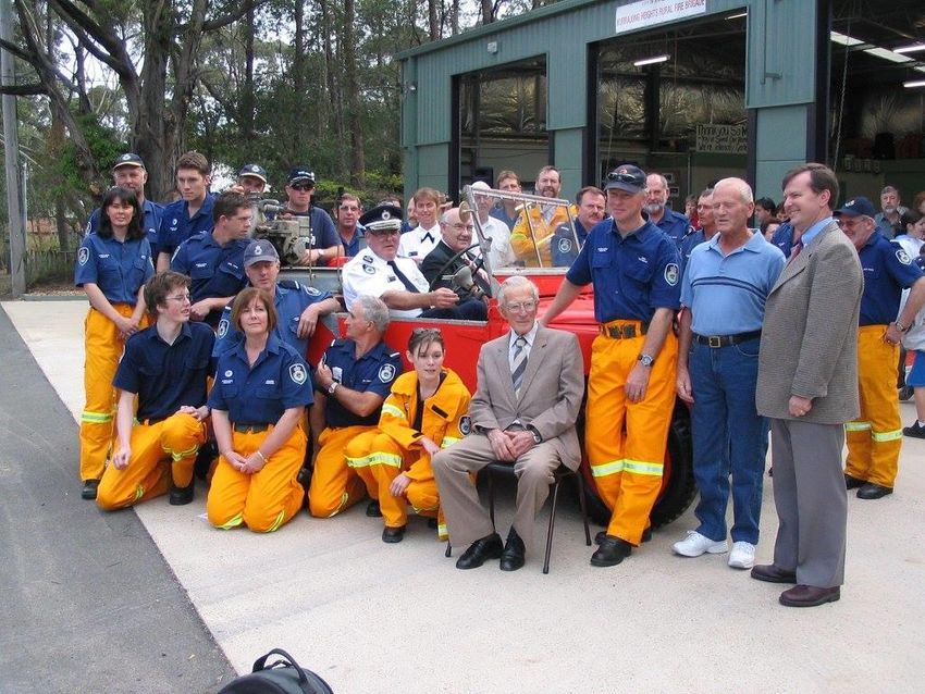
BACKGROUND & HISTORY

                        THE MOSAIC APPROACH
   • The KH Mosaic approach to
     hazard reduction has been in use
     since the brigade’s inception
        • The zone pattern is three plots deep
          and the cycle of hazard reduction is
          12 years
        • In an extreme fire at least one of
          the zones will provide a ‘block’
        • The low heat burn protects fauna
          and flora
        • Each burn only covers about 70% of
          the area – stay out of the gullies
   • Time since HR burn                                 Our mosaic approach burns slowly down the slope.
        • 1 year – fire can self extinguish            Koalas go up the trees and snakes go into the ground.
                                                         The RFS preferred approach is to burn a complete
        • 5 years – fire can be easily managed         circle. It takes less time but destroys more fauna and
        • 9 years – fire manageable because                                       flora
          it’s slowed by adjoining block
MARCH 2020                   KURRAJONG HEIGHTS RFS BRIGADE REPORT TO COMMUNITY                                  10
BACKGROUND & HISTORY
MAJOR FIRES HISTORY
• All our major fires have started in
the Wollemi or Blue Mountains
National Parks & have been
mainly driven by hot and strong
NW winds
• In 2001 the fire entered Yarramundi
and Blaxland Ridge with the loss of
14 houses. 4 people sustained
injuries. A further 12 houses were
destroyed in the Blue Mountains
• In 2013 the State Mine Fire quickly
moved to Bilpin covering over 30km
in one day. It was stopped by a
back burn along the Mountain
Lagoon Rd
MARCH 2020 KURRAJONG HEIGHTS RFS BRIGADE REPORT TO COMMUNITY 112019
PREPARATION
AROUND THE VILLAGE/1
• This shows each part of the
mosaic and the year of HR
• 7, 11, 12 & 18 were burnt in
2001 … 18 years
• 1, 2 & 3 had not been burnt for
11 years
• 15 was burnt in 2009 … 10 years
• Part of 6 & 14 were burnt in
2010 … 9 years
• 4, 5 and part of 6 were burnt in
2012 … 7 years
• 8 was burnt in 2016 … 3 years
• 9, 10 & 13 were burnt in 2017 …
2 years
• 16 & 17 were burnt in 2019 …
1 year
MARCH 2020 KURRAJONG HEIGHTS RFS BRIGADE REPORT TO COMMUNITY 122019
PREPARATION
AROUND THE VILLAGE/2
• This is the same map
showing all the areas that
had not had Hazard
Reduction for 9 years or
more shaded in red
• Any fire coming from the
West or the North would be
potentially unstoppable
• This is why we advised you to
evacuate before the bad day
on December 21st
MARCH 2020 KURRAJONG HEIGHTS RFS BRIGADE REPORT TO COMMUNITY 132019
PREPARATION – NATIONAL PARKS
• National Parks manages over 7
million hectares of land
• It completed HR over 135,000
hectares in 2019
• In the previous 5 years a total of
635,000 hectares were burnt
• This amount is double what was
burnt in the previous decade
• This is an average of 1.9% per
annum
• Another way to look at this is it
would take more than 50 years to
complete HR in our parks
• Clearly these targets are not
compatible with responsible
management of our bushland and
the safety of our community National Parks completely encircle Sydney
and comprise 69% of our Hawkesbury land
MARCH 2020 KURRAJONG HEIGHTS RFS BRIGADE REPORT TO COMMUNITY 142019
GOSPERS MOUNTAIN FIRE/1
Photo credit: Jeremy Braithwaite
• The Gospers Mountain Fire
started with a lighting strike on
October 26th
• After a couple of weeks it reached
the Putty Rd
• By mid November it had crossed the
Putty Rd and was threatening St
Albans and the Upper Macdonald
MARCH 2020 KURRAJONG HEIGHTS RFS BRIGADE REPORT TO COMMUNITY 152019
GOSPERS MOUNTAIN FIRE/2
Photo credit: Jeremy Braithwaite
• On 23rd November Mountain • Explained how they would put in
containment lines along Mountain Lagoon
Lagoon Brigade called a Rd and across to Colo Heights
community meeting • Brian Williams attended
• 3rd from left, front row
MARCH 2020 KURRAJONG HEIGHTS RFS BRIGADE REPORT TO COMMUNITY 162019
GOSPERS MOUNTAIN FIRE/3
15th December
View from Burralow Rd lookout
Photo credit: Jeremy Braithwaite
MARCH 2020 KURRAJONG HEIGHTS RFS BRIGADE REPORT TO COMMUNITY 172019
GOSPERS MOUNTAIN FIRE/4
• This shows the status on 18th
December
• The containment lines from Bilpin
to Mountain Lagoon to Colo are in
and the back burn has advanced
towards the main fire front
• The back burn from Mt Wilson to
Bell was unsuccessful and crossed
Bells Line of Road into the Grose
Valley
• We hold a community meeting at
Kurrajong Heights and advise all
residents who are not well prepared
AND able bodied to evacuate
• A majority of residents took this
advice, left their properties well
prepared, and had maps and
instructions. This made our jobs a
lot easier
MARCH 2020 KURRAJONG HEIGHTS RFS BRIGADE REPORT TO COMMUNITY 182019
GOSPERS MOUNTAIN FIRE/5
MARCH 2020
Photo credits: Jeremy Braithwaite KURRAJONG HEIGHTS RFS BRIGADE REPORT TO COMMUNITY 192019
GOSPER MOUNTAIN FIRE/5
Position on 20th
December
Red dots are active
hotspots and show
what is burning
Red shaded area
shows what has been
burnt
RFS issues fire path
prediction for 21st
December showing
Kurrajong Heights
being engulfed by fire
MARCH 2020 KURRAJONG HEIGHTS RFS BRIGADE REPORT TO COMMUNITY 202019
GOSPERS MOUNTAIN FIRE/6
• December 21st
• Very hot and windy conditions
• Heavy smoke and an inversion
layer damped the wind, but the
the fire was very close to Kurrajong
Heights by late afternoon
• Then suddenly a huge southerly
arrived
• Gary Jol was at the top of Warks
Hill Rd when it hit
• All the smoke cleared and the
whole fire erupted. “We looked
at each other and our hairs were
standing on end …”
• The fire took off and destroyed a Photo credit: Lyn Ward
number of buildings around Bilpin Photo taken by Lyn Ward from Grose Vale Road near
• Without our mosaic pattern of Kurrajong looking up to the escarpment
hazard reduction in place,
particularly behind Glen Huntley,
this fire could have proved
devastating for Kurrajong Heights
MARCH 2020 KURRAJONG HEIGHTS RFS BRIGADE REPORT TO COMMUNITY 212019
GOSPERS MOUNTAIN FIRE/7
TERRY HILLS RFS HILLBILLY CIDER
https://www.facebook.com/125790644233859/videos/181614176419955 https://www.facebook.com/353839928032375/videos/443050466364257
MARCH 2020 KURRAJONG HEIGHTS RFS BRIGADE REPORT TO COMMUNITY 222019
BACKBURNING OPERATIONS/1
• December 22nd
• The wind died down and a week of
calm weather was forecast
• Under our emergency powers we
were able to immediately put into
place the protection that we had
not been allowed to do earlier:
• Back burning and containment
lines around Kurrajong Heights and
down Burralow Rd and all the way
to the Grose River … in total more
than 20km
• The back burn was very successful
and joined up with the main fire
• Bowen Mountain remained
exposed and Kurrajong Heights
remained exposed to a fire from
the North
MARCH 2020 KURRAJONG HEIGHTS RFS BRIGADE REPORT TO COMMUNITY 232019
BACKBURNING OPERATIONS/2
• December 29th on our Facebook page:
• Crews have been working tirelessly the last few days on
local containment lines for the Gospers Mountain Fire.
Burralow Rd, Tabaraga and Donnas Track containments
have linked up with Wentworth Creek, Blue Mountains
• The Gospers Mountain Fire is still active in the vicinity of
Mt Lagoon/Glenara Road area. This means the fire is
working its way towards Wheeny Creek
• There is currently RAFT teams working in this area to
keep the fire on the ‘Mt Lagoon’ side of Wheeny Creek.
We are hoping it will eventually come to a stop and burn
itself out
• There are 3 fallback lines in place. Crews, machinery etc
have also been working on these.....
• From ‘Rossi’s’ along the Middle Island track to
Middle Island
• From ‘Rossi’s’ towards Little Island
• From East Street / Leidich Lane to Douglas Farm
Rd
• These containment lines will be used if the Wheeny
Creek containment lines cannot hold the main fire front
that is approaching
• We could only send the RAFT teams into the Wheeny Creek
area because of prior Hazard Reduction
Photo credit: Joep Berben
MARCH 2020 KURRAJONG HEIGHTS RFS BRIGADE REPORT TO COMMUNITY 242020
BACKBURNING OPERATIONS/3
• January 7th
• Another hot day and the wind is
from the west
• The containment lines that have
been put down in the Grose from
Donna’s Track are all successful
• The rains come!
• At long last the weather comes to
our aid
• The Gospers Mountain fire was
officially declared to be contained
on the 14th January
• Previous longest fire was 44 days.
This was 79 days
Photo credit: FiresNSW app
MARCH 2020 KURRAJONG HEIGHTS RFS BRIGADE REPORT TO COMMUNITY 252020
KURRAJONG HEIGHTS BRIGADE SUMMARY
• Over 79 days, our 31 active
members were part of 107
crews tasked during the
campaign
• The Gospers Mountain fire is
believed to be the world’s
largest fire from a single
ignition point, burning
approximately 515,000
hectares, with a perimeter
of 1,380 km
• This fire was dangerous,
exhausting and
devastating. Even for
seasoned fire fighters it Photo credit: Jeremy Braithwaite
was difficult to come to
terms with amount of loss
and devastation
MARCH 2020 KURRAJONG HEIGHTS RFS BRIGADE REPORT TO COMMUNITY 262020
THANK YOU ALL VERY MUCH!!
• The support given to us by our
community during this time was
invaluable
• Our community generously donated
time, food, drinks, money and their
moral support
• People came to the fire shed to help
and to feed us
• These businesses all made an
incredible contribution
• Special mention to Lochiel House who
were just incredible
• Many thanks also to all the
neighbouring brigades, others
from further afield and a very
special thanks to Fire & Rescue
NSW
• Your support really meant a great
deal to all of us
MARCH 2020 KURRAJONG HEIGHTS RFS BRIGADE REPORT TO COMMUNITY 272020
CURRENT STATUS
• Our main exposures
• Areas to the north and north
east of Kurrajong Heights
• 20 years of fuel is of major
concern
• The community needs to
remain vigilant to see that
these fuels are reduced as
soon as possible
MARCH 2020 KURRAJONG HEIGHTS RFS BRIGADE REPORT TO COMMUNITY 28FREQUENTLY ASKED QUESTIONS
QUESTIONS
• How are Hazard Reductions
Approved?
• What is Aboriginal Burning?
• Do large Air Tankers help?
• Does Hazard Reduction increase
CO2 levels?
• Your questions
• What’s Next? Actions …
MARCH 2020 KURRAJONG HEIGHTS RFS BRIGADE REPORT TO COMMUNITY 29FREQUENTLY ASKED QUESTIONS
HOW ARE HAZARD REDUCTIONS
APPROVED?/1
• All HR burns must comply with the
Bushfire Environmental Assessment
Code. Requires
• All land owners and managers approval
• Determination of vegetation types. This
is used to determine the fire interval
• Fire intervals at Kurrajong Heights range
from 10 to 25 years
• Identification of all threatened species
• Identification of aboriginal heritage sites
• The threatened species list extends to
many pages
• Failure to observe all requirements is a
criminal act
MARCH 2020 KURRAJONG HEIGHTS RFS BRIGADE REPORT TO COMMUNITY 30FREQUENTLY ASKED QUESTIONS
HOW ARE HAZARD REDUCTIONS
APPROVED?/2
• Once the Environmental
Bushfire Assessment Code
has been navigated the
brigade can submit a
proposal to the Hawkesbury
Bush Fire Management
Committee
• The proposal may not even
get past the planning sub-
committee
• The HBFMC members
represent many different
agencies and groups
• The approval process can be
long and complicated. From
application to completion of
the hazard reduction can take
many years
MARCH 2020 KURRAJONG HEIGHTS RFS BRIGADE REPORT TO COMMUNITY 31FREQUENTLY ASKED QUESTIONS
WHAT IS ABORIGINAL BURNING?/1
• A different form of mosaic burning where each
vegetation type is burnt at different times of
the year
• When one vegetation is ready to burn the
neighbouring vegetation will be green and will put
the burn out
• They never light a fire unless they know where it
will go and where it will stop
• Cool burns give off a white smoke and do not go up
the trees or into the canopy
• During the fire the insects and other small animals
can crawl up the trees to safety, while ants and
snakes can retreat down into their nests
• The fire is burnt in a circular pattern from the www.mulong.com.au: Local community, rangers and rural fire service
members ‘walk with the fire’, out on country at a Cape York fire workshop
right ignition point
• Initially the country may be burnt every year
until weeds and other invasive species are
removed. In healthy country it may be every 2
or 3 years or more between burns
• Some country like rainforest is not burnt; but
the country round it is burnt to protect it
• Hazard Reduction is a by-product of restoring a
healthy landscape with abundant food for
people, animals and birds. This country will not
generate a mega fire
www.mulong.com.au: In 2015, the Tasmanian Aboriginal Fire
Team reimplemented traditional burning – an historic event
MARCH 2020 KURRAJONG HEIGHTS RFS BRIGADE REPORT TO COMMUNITY 32FREQUENTLY ASKED QUESTIONS
WHAT IS ABORIGINAL BURNING?/2
Further reading:
• Victor Steffensen’s book “Fire
Country” was released on 18th
February and describes his life’s
work learning how to manage the
land with fire and teaching the
skills to others. Required reading!
• Victor’s website:
http://www.mulong.com.au/
• Koori Firesticks:
http://www.kooricountryfiresticks.com.au/home.html
• Living Projects. Land management
around the country:
http://www.livingknowledgeplace.com.au/ausmap.php
https://www.booktopia.com.au/fire-country-victor-steffensen/book/9781741177268.html
MARCH 2020 KURRAJONG HEIGHTS RFS BRIGADE REPORT TO COMMUNITY 33FREQUENTLY ASKED QUESTIONS
DO AIRCRAFT HELP?
• Benefits
• LATs drop a large load of retardant in one
place
• Helicopters can slow impact of fire and
have short turn around time
• Helicopters can assist and communicate
with ground crew closely
• Disadvantages
• LATs are expensive and have a long turn
around time
• Aircraft are restricted by smoke and wind
• Aircraft are governed by air bases, fuel, Photo credit: Flight Global
water or retardant sources and external
priorities
• We have to clear the area before a LAT
drop. If you were underneath it could The retardant contains a pink dye and
really harm you is meant to be bio degradable. If it
• When aircraft are required for fire suppression
it is clear that this is managing under crisis drops on your roof it will also get in
your water tank and this will need to
be emptied and professionally
cleaned
MARCH 2020 KURRAJONG HEIGHTS RFS BRIGADE REPORT TO COMMUNITY 34FREQUENTLY ASKED QUESTIONS
DOES HR INCREASE CO2 LEVELS?
• The quick answer is no
• The choice is essentially between
trying to suppress large wildfires
caused by minimal HR or conduct
frequent HR burns
• The megafires release 40 or 50
million tonnes of CO2
• They also destroy the tall trees
which are required to capture the
carbon
• The HR burns, or better the Read the full paper by Roger Underwood, David
Packham and Phil Cheney:
aboriginal burns, release a small
https://www.bushfirefront.org.au/resources-
amount of carbon which is quickly 2/further-reading/bushfires-and-global-warming/
recaptured and are essentially
neutral in terms of CO2 emissions
MARCH 2020 KURRAJONG HEIGHTS RFS BRIGADE REPORT TO COMMUNITY 35FREQUENTLY ASKED QUESTIONS
IS CLIMATE CHANGE A FACTOR?
• Climate change can produce
longer hotter summers and
increased fuel loads
• Increases the imperative for HR
• During a major fire
• A 1 or 2 degree temperature
increase makes little difference to
the fire behaviour
• The main contributor to fire
intensity is the fuel loads
• Double the fuel load = double the
rate of spread AND quadruple the
intensity of fire
• The danger for us is if the correct
management of the bush gets
lost in political debate * https://www.dfes.wa.gov.au/safetyinformation/fire/bushfire/BushfireInfoNotesPublications/DFES-InfoNote-ForestFuelLoadsinUrbanInterface.pdf
• But once everyone in the
community understands that
aboriginal burning can restore the
bush and make it pristine again, we
have a clear way forward
MARCH 2020 KURRAJONG HEIGHTS RFS BRIGADE REPORT TO COMMUNITY 36FREQUENTLY ASKED QUESTIONS
WHATS NEXT? ACTIONS ….
• We will face the same catastrophic
fires over and over again unless
something changes
• You can make this change happen and
be part of the solution
• You can do this by lobbying for
widespread low intensity, cool
burning hazard reduction
• Lobby by writing one email and
collectively send to the following:
• Local Government
• State Government
• Federal Government
• Hawkesbury RFS
• RFS Commissioner
• Director General Office of
Environment and Heritage
• NPWS Office, Richmond
• Hawkesbury Bush Fire Management
Committee c/- RFS
MARCH 2020 KURRAJONG HEIGHTS RFS BRIGADE REPORT TO COMMUNITY 37FURTHER READING
LINKS TO RELEVANT INFORMATION
• There are some excellent • Leading bushfire experts include:
resources to increase your • Victor Steffensen
bushfire knowledge and • David Packham
• Phil Cheney
understanding • Vic Jurskis
• Some websites include:
• The Volunteer Fire Fighters
Association
www.volunteerfirefighters.org.au
• Bushfire Front
www.bushfirefront.org.au
MARCH 2020 KURRAJONG HEIGHTS RFS BRIGADE REPORT TO COMMUNITY 38You can also read