Requested Plan Change to the Hamilton District Plan: Waikato Section (2012) - 19 June 2013 - EPA NZ
←
→
Page content transcription
If your browser does not render page correctly, please read the page content below
Requested Plan Change to the
 Hamilton District Plan: Waikato
                  Section (2012)
                         19 June 2013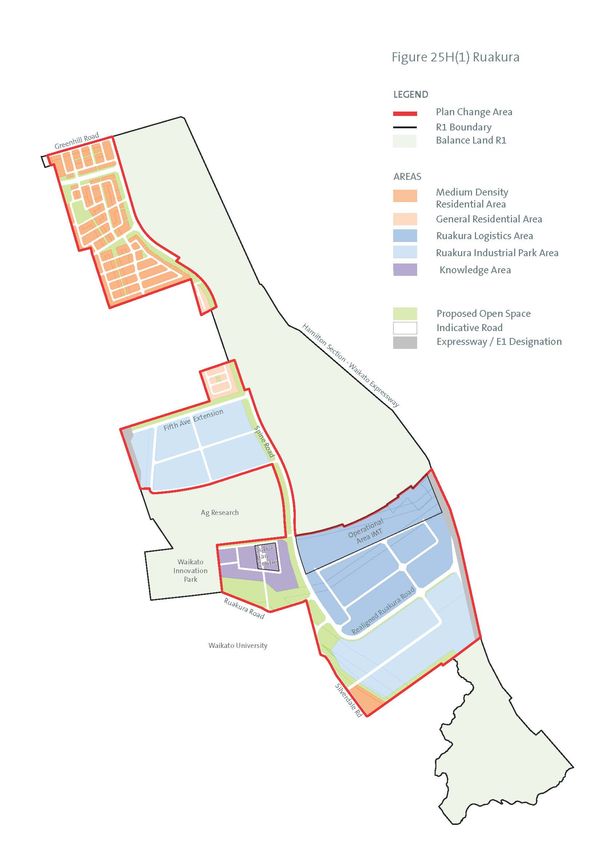
Explanatory Note [This does not form
part of the plan change request]
In 2005 a strategic agreement was reached between Hamilton City Council and
Waikato District Council to transfer approximately 822ha of land from the Waikato
District to Hamilton City. The Local Government Act order which put in place the
transfer referred to this land as “R1”. On 1 July 2011this land became part of Hamilton
City.

Where boundary adjustments occur, section 81(3) of the Resource Management Act
sets out that changes to bring the transferred land into the new authority’s district plan
should occur as soon as practicable but within 2 years. Until this occurs, the land
remains subject to the Hamilton District Plan: Waikato Section, which is a separate
statutory planning document from the Waikato District Plan.

At the time of the transfer, the Waikato Regional Council and the Future Proof group
were putting in place a strategic direction for the Region which identified the R1 land
was an important future employment location for Hamilton City. This direction was
supported by Hamilton City Council’s strategic planning approach which saw the
provision of employment and economic activity on the eastern side of Hamilton would
assist in balancing the economic activity of the City which was heavily concentrated
on the western side of the Waikato River and putting pressure on the capacity of the
limited number of bridges across the river, particularly during peak traffic times.

A structure planning process was undertaken to consider the urban development of
the R1 land. This process included identifying and planning for a secure economic
anchor for the area to facilitate the desired employment growth for the City. An
intermodal terminal (freight and logistics infrastructure) was identified as the preferred
anchor capitalising on the location which adjoins the existing rail corridor and strategic
road connections under construction such as Waikato Expressway and E1 arterial road.

The Structure Plan was adopted by Hamilton City Council and the necessary provisions
to implement the plan were incorporated into the Proposed Hamilton District Plan. The
Proposed Hamilton District Plan was notified in 2012 and is currently working through the
planning process.

However, the Hamilton District Plan: Waikato Section which currently applies to the R1
land includes an Urban Expansion Policy Area which restricts most land use and
subdivision activities on the R1 land by identifying them as Prohibited Activities for which
no resource consent applications can be lodged or approved. These provisions were
imposed by the Waikato District Council, prior to the land transfer and have been
historically used throughout the Waikato District to prevent development which may
foreclose future urban use for Hamilton City.

The structure planning process also informed the Proposed Regional Policy Statement
which incorporates the same strategic direction for Ruakura. While the Proposed
Regional Policy Statement is not yet operative, the provisions applying to Ruakura are
beyond challenge.

                                                                                               1
As a consequence of the extensive planning and investigation work and the
endorsement of the structure plan at both the regional and district level, it is considered
inappropriate for the operative planning provisions to maintain such a restrictive control
on the land.
Therefore Tainui Group Holdings Limited and Chedworth Properties Limited, who own
three quarters of the land in R1, make this Plan Change request to enable the
commencement of the planning for the first stages (approximately 389ha) the R1 land
in accordance with the adopted Ruakura Structure Plan . This “Plan Change” land will
be subject to a new Schedule 25H Ruakura to be inserted in Chapter 25 Rural of the
Hamilton District Plan: Waikato Section. The Schedule will provide a new set of provisions
for activities on the land consistent with the adopted structure plan. Schedules are an
existing planning tool used in the Hamilton District Plan: Waikato Section to provide for
specified development and is currently applied to the Waikato Innovation Park
(Schedule 25B) and AgResearch developments (Schedule 25C).
The new Schedule 25H Ruakura will provide a Ruakura Logistics Area (incorporating the
Intermodal Terminal (IMT)), Ruakura Industrial Park Area, Knowledge Area, Residential
Areas and Open Space Areas along with indicative roads. The Plan Change land is all
in the ownership of one of the two plan change applicants with the exception of five
properties located within the proposed Ruakura Logistics Area. Importantly this plan
change is to the Hamilton District Plan: Waikato Section so if approved will only have
interim effect until the Proposed Hamilton District Plan review process is completed and
the Plan is made operative. The Requested Plan Change amends the Prohibited
Activity rules to enable the planning and development of the future roading network
required to develop the land. The plan change applicants consider that it is desirable in
the long term for the provisions on the land to be consistent with the Proposed Hamilton
District Plan and for that reason have sought to change the operative planning
document applying to the land rather than seek to accelerate the Proposed Hamilton
District Plan provisions for the entire R1 land.
The land brought forward for development is not anticipated to be fully developed
before the Proposed Hamilton District Plan concludes the plan change process, rather it
is to provide potential investors in the facility with the certainty that the Ruakura
Logistics facility is going to be provided for in the planning framework.
In addition to inserting the new Schedule 25H Ruakura, the Plan Change results in the
following three other consequential amendments:
1. Amend Planning Map 20 to identify the area subject to the new Schedule 25H
and remove the Urban Expansion Policy Area notation;
2. Amend Rule 25.5 Prohibited Activities in the Rural Chapter clauses (d),( e) and
(f) to allow subdivision in the Schedule 25H area and the development of new
roads in the entire R1 area; and
3. Amendments to the policy framework in Chapter 6 Built Environment to provide
for Schedule 25H Ruakura.
Given the time sensitivities surrounding the proposed Intermodal Terminal, it is
considered that the landowners cannot await the outcome of the Proposed Hamilton
District Plan. Unlike the remainder of Hamilton City where the operative planning
2provisions allow a resource consent to be lodged and considered on its merits, the R1
land is frustrated by the historical prohibited activities rules applied in the Waikato
District. With the transfer of this area to Hamilton City and the completion of a
comprehensive structure planning process for this area the prohibited activity rule is no
longer appropriate to the circumstances of the R1 land.
The following document sets out the four components of the requested plan change to
the Hamilton District Plan: Waikato Section 2012.
The amendments involve:
1. Add Schedule 25H Ruakura to Chapter 25 (text and maps)
2. Amendments to Rule 25.5 Prohibited Activities
3. Amendments to Chapter 6 Built Environment
4. Amendments to Planning Maps 14 and 20
31. Schedule 25H Ruakura
(a) Amend Chapter 25 Rural Zone by inserting the following new schedule following
schedule 25G- Maramarua McCorquindale and Aramiro Forests.
Schedule 25H Ruakura
25H.1 Introduction
25H.1.1 Application of the Schedule
In this schedule Ruakura means the land shown in Figure 25H(1).
25H.1.2 Application of Rural Zone Rule
All rules in Chapter 25: Rural Zone apply to the Ruakura Schedule Area except where
inconsistent with a rule in this schedule, in which case the rule in the schedule will apply.
Where reference is made in this schedule to the provisions of the Operative HDP these
rules form part of the schedule and supersede the equivalent chapter 25 rule.
25H.1.3 Relationship to Other Schedules in this Chapter
This Schedule is proximate to land covered by Schedules 25B and 25C.
It is noted that the Schedules in 25B and 25C will continue to apply until such time as the
use within these areas changes in accordance with the Schedule in 25H Ruakura.25H.2
Schedule 25H Ruakura.
25H.2.1 Purpose
The purpose of Schedule 25H Ruakura is to put in place some of the key elements of the
Ruakura Structure Plan. The Ruakura Structure Plan is incorporated into the Proposed
Hamilton District Plan (2012).
4Figure 25H(1) Ruakura
525H.2.2 Overview of Areas Schedule 25H Ruakura
Ruakura comprises the following areas:
• Ruakura Logistics Area (see Rule 25H.3)
• Ruakura Industrial Park Area( Rule see 25H.4)
• Knowledge Area(see Rule 25H.5)
• General Residential Area (refer rule 25H.6 and Hamilton District Plan Residential
zone)
• Medium Density Residential Area; providing for 5 areas to be the subject of a
Comprehensive Development Plan (see Rule 25H.7)
• Open Space Area (refer Rule 25H.8 and Hamilton District Plan Recreation
General zone)
• Roads
The Schedule also identifies the following provisions which take precedence over any
more general rule in the Plan:
• Noise and Vibration Rules
• Staging
• General Rules
• Definitions
25H.3 Ruakura Logistics Area
25H.3.1 Purpose
(a) Ruakura is strategically located and is of an appropriate scale to satisfy growing
national demand for enhanced freight-handling infrastructure. It is ideally
placed to process containers originating at the Ports of Tauranga and
Auckland, and as such has the ability to realise significant agglomeration
benefits. It is the preferred location in Hamilton City to establish an inland port.
(b) Agglomeration benefits arise from the fact that production costs fall as related
businesses cluster together, share infrastructure, provide economies of scale and
reduce the cost of handling and moving freight between Auckland, Bay of
Plenty and Waikato regions. With a direct connection to the Waikato
Expressway, environmental benefits, including reduced carbon emissions and a
reduction in congestion, can also be realised.
(c) The inland port will be developed adjacent to the existing rail infrastructure (East
Coast Main Line) and the Waikato Expressway. The location of both road and
rail infrastructure allows the proposed port to be intermodal, so freight can be
transferred between rail and road transport. Railway sidings will be required off
6the main line and other critical infrastructure includes the development of
container hardstand areas, lighting masts, security infrastructure, CCTV,
communications and data management, as well as fire and hazardous
substance response facilities. The development of a comprehensive stormwater
management and treatment network through an Integrated Catchment
Management Plan will also need to be planned for at the outset of
development.
(d) Due to the costs involved in developing an inland port, and the nature of the
infrastructure (such as security and MAF/Customs facilities), it is important that
the freight and logistics area is occupied by businesses which use the port’s
facilities, rather than more general industrial or employment activities. A critical
mass of such businesses is required for the inland port to be economically
successful.
(e) The Logistics Area will generally comprise large warehouses and large areas of
hardstand. Logistics and freight-handling activities include container storage,
container unloading/loading, MAF/Customs procedures, warehousing,
distribution/consignment activities, utilities and all ancillary activities including
container, equipment and fleet maintenance and administration activities.
Note
1. There are a small number of existing residential dwellings within or near to the Ruakura
Logistics Area, in particular in an area zoned Country Living. While acknowledging that the
amenity of these dwellings may be affected by the construction and operation of the
Waikato Expressway and the operation of the main trunk railway line, adverse effects that
may result of inland port and logistic activities shall be addressed by controls on noise and
glare. As many of these dwellings are located on large rural or lifestyle properties a notional
residential curtilage of 20m from the external walls of any dwelling shall determine where
these amenity controls are to be measured.
25H.3.2 Rules – Activity Status Table
Activity Class
Logistics and freight-handling activities P
Logistics and freight-handling infrastructure P
New buildings accessory buildings and alterations and additions P
(outside the Interface Design Control Area)
New buildings (within an Interface Design Control Area) C
Alterations and additions to existing buildings within the Interface C
Design Control Area (other than minor works)
Minor works to an existing building P
P
Food and beverage outlets and dairies not exceeding 100m2 gross
floor area
Demolition/removal of existing buildings P
7Maintenance and repair to existing buildings (except scheduled P
heritage buildings)
Farming P
Short-stay worker accommodation C
Ancillary residential units C
All other activities which do not meet the requirements of Rule D
25H.3.5
25H.3.3 Rules –General Rules
25H.3.3.1 Application
(a) All permitted activities listed in table 25H.3.2 shall comply with the standards set
out in 25H.3.5:
(b) All controlled activities, shall:
(i) be assessed against the Purpose for the Ruakura Logistics Area in
25H.3.1;
(ii) be assessed against the relevant assessment criteria in 25H.3.4; and
(iii) comply with the standards set out in 25H.3.5.
25H.3.4 Assessment Criteria
25H.3.4.1 Controlled Activities: Matters of Control
(a) In determining any application for resource consent for a controlled activity, the
Council shall reserve its control over the following matters.
Activity Matters of Control
i. New buildings within an 1) Impact of building design,
Interface Design Control external appearance,
Area* signage and configuration
on the public realm
ii. Alterations and additions
particularly when viewed
within the Interface Design
from open space areas,
Control Area (other than
arterial roads and the
minor works)*
Waikato Expressway.
2) Site layout
3) Landscaping
iii. Short-stay worker 1) Noise
accommodation*
2) Industrial hazard risk
iv. Ancillary residential units*
3) Reverse sensitivity
825H.3.5 Rules – Standards
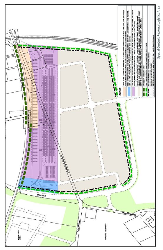
The following standards apply to the areas identified on Figure 25H(2) Special Controls
Ruakura Logistics Area.
25H.3.5.1 Site Coverage
Site coverage Maximum site coverage
80%
25H.3.5.2 Permeable Surfaces
Permeability Minimum 20%
25H.3.5.3 Building Height
a) Height of buildings(including loading Maximum 20m
ramps, link spans, machinery rooms
and cranes and other lifting or
stacking equipment outside the
Inland Port)
b) Height of loading ramps, link spans, Maximum 35m
machinery rooms and cranes and
other lifting or stacking equipment
within the Inland Port
c) Height of container stacking within Maximum 25m
the Inland Port, except as identified
in (d) below
d) Height of container stacking within Maximum 12m
100m of the northern boundary of
the Inland Port, or within 100m of the
Spine Road as identified on Schedule
25H Ruakura
e) Height of container stacking outside Maximum 12m
the Inland Port
f) Height of lighting towers, poles, Maximum 35m
aerials and flagpoles
25H.3.5.4 Building Setbacks
i. Any transport corridor boundary 10m
ii. Any boundary adjoining the Waikato Expressway 15m
designation
iii. Any boundary adjoining the Railway designation 0m
iv. Internal boundaries within the Ruakura Logistics Area 0m
(excluding as provided for by i – iv above)
925H.3.5.5 Landscape Screening
(a) Each stage of the inland port shall be accompanied by a planting strip not less
than 5m wide, on the northern boundary with a minimum height of 1.5m. The
planting strip must be established prior to the establishment of that stage of the
inland port. It must be maintained thereafter to provide for the screening of the
facility from residential dwellings located on Ryburn Road. The landscape
screening must either be located:
i. Within the northern boundary of the site, or
ii. Within the Ryburn Road, road reserve, subject to an appropriate
legal agreement between Tainui Group Holdings Limited and
Hamilton City Council. Tainui Group Holdings Limited would have
sole responsibility for the funding and ongoing maintenance of the
planting.
(b) Where fencing is required to meet specialised security needs (e.g. Ministry of
Agricultural quarantine specifications) a 6m high permeable fence may be
used, provided that a 10m wide planting or buffer strip shall be provided along
boundaries with any transport corridor or open space area.
25H.3.5.6 Interface Standards
(a) No storage, stacking, loading or unloading of containers shall take place
forward of the front building line of any building fronting a transport corridor or
the Waikato Expressway.
25H.3.5.7 Noise and Vibration Standards
(a) Activities should also comply with any relevant noise and vibration rule in 25H.9.
25H.3.5.8 Staging
(a) Activities should also comply with any staging rule in 25H.10.
1011
25H.4 Ruakura Industrial Park Area

     25H.4.1 Purpose
       (a) The Ruakura Industrial Park Area is an important component of the overall
           development concept for Ruakura. Ruakura is strategically located and is of an
           appropriate scale to enable the development of a large, structure planned
           urban extension. The core to the development concept is the creation of an
           inland port surrounded by a logistics hub.

       (b) Key attributes of the Ruakura Industrial Park Area include its location adjoining
           strategic infrastructure, including the expressway, the inland port, and key
           educational, research and innovation facilities and the co-locational benefits for
           businesses that are derived from these facilities. Its location means it also has an
           important role as a gateway into Hamilton.

       (c) The industrial park concept will be achieved by requiring a high standard of
           design for all buildings, landscaping and buffer areas and restricting certain
           types of industrial activities. This includes requiring setbacks from sensitive land
           uses including a 40m setback from existing residential development to the south-
           east of the Structure Plan area.

       (d) The provisions also seek to ensure that the Ruakura Industrial Park Area is not
           occupied by land uses that are non-industrial, unless they are either ancillary to
           industrial use, support industrial uses, or are more appropriately located within an
           industrial environment than a business centre. This will reduce the potential for
           industrial land to be diluted by non-industrial uses, resulting in pressure for new
           industrial land to be zoned elsewhere, and for existing industrial land to be
           rezoned to commercial use.

     25H.4.2 Rules – Activity Status Table
          Activity                                                              Class
              a) New buildings                                                    P
              b) New buildings (within an Interface Design Control                C
                 Area)
              c) Industrial activity excluding Activities (f) to (j) below        P
              d) Any activity requiring an air discharge consent under           RD
                 the Waikato Regional Plan within 100m of residential
              e) Logistics and freight-handling activities                        P
              f)   Any noxious or offensive activity                             NC
              g) Motor vehicle dismantling and repair                            NC
              h) Recycling Plants including the associated storage of            NC
                 metals, plastics, glass, electronic components or
                 batteries prior to processing

12
i) Processes involving the flaring or incineration of trade NC
wastes or refuse
j) The manufacture or blending of bulk products of NC
fertiliser, animal feed, roading materials, gardening
materials, concrete and aggregate
k) Offices NC
l) Ancillary offices P
m) Retail NC
n) Wholesale retail and trade supplies RD*
o) Transportation service centre RD*
p) Drive-through services RD*
q) Commercial motor vehicle sales and servicing RD*
r) Motorised recreation activity D
s) Yard-based retail other than as provided for as a NC
permitted activity
t) Food and beverage outlets and dairies not exceeding P
250m2 gross floor area
u) Ancillary retail P
v) Emergency service facilities RD*
w) Passenger transport facilities P
x) Transport depot RD*
y) Parking lots and parking buildings P
z) Accessory buildings P
aa) Minor works to an existing building P
bb) Alterations and additions (other than minor works) P
cc) Ancillary residential unit RD*
dd) Childcare facilities RD*
ee) Permitted activities which fail to meet the criteria in RD
Rule25H.4.5
ff) All other activities which do not meet the requirements NC
of Rule 25H.4.5
25H.4.3 Rules – General Rules
25H.4.3.1 Application
(a) All permitted activities listed in Table 25H.4.2 shall comply with the standards set
out in 25H.4.5:
(b) All activities listed in Rule 25H.4.2, other than permitted activities, shall:
13(i) be assessed against the Purpose for the Ruakura Industrial Park Area in
25H.4.1;
(ii) Comply with the general standards in Rule 25H.4.5 and, where relevant, the
specified standard in Rule 25H.4.6,
(iii) Be assessed against the assessment criteria in Rule 25H4.4
25H.4.3.2 Notification Rule
(a) Except as provided for by sections 95A(2)(b) and (c), 95B(2) and (3) and 95C(1)
to (4) of the Act applications for any Restricted Discretionary Activity identified
with an asterisk (*) in the table above will be considered without notification or
the need to obtain approval from affected persons.
25H.4.4 Assessment Criteria
25H.4.4.1 Controlled Activities: Matters of Control
(a) In determining any application for resource consent for controlled activity, the
Council shall reserve its control over the following matters.
Activity Specific Matter of Control
i. New buildings (within an 1. Impact of building design,
Interface Design Control external appearance, signage
Area)* and configuration on the
public realm particularly when
viewed from open space
areas, arterial roads and the
Waikato Expressway.
2. Site layout
3. Landscaping
25H.4.4.2 Restricted Discretionary Activities: Matters of Discretion
(a) In determining any application for resource consent for a restricted discretionary
activity, Council shall have regard to the matters referenced below, to which
Council has restricted the exercise of its discretion.
Activity Specific Matter of Control
i. Any activity requiring an air 5.
discharge permit under the
Waikato Regional Plan within
100m of residential
ii. Wholesale retail and trade 1, 2, 6, 7, 8.
supplies*
iii. Transportation service 1, 2, 6, 7, 8
centre*
iv. Drive-through services* 1, 2, 6, 7, 8
14v. Commercial motor vehicle 1, 2, 6, 7, 8
sales and servicing*
vi. Transport depot* 2, 7, 8
vii. Ancillary residential units* 6, 7, 8, 9
viii. Childcare facilities* 6, 7, 8, 9.
ix. Emergency services facilities* 7.
x. Any permitted or other 3, 4
activities not complying with
any relevant standard in Rule
25H.4.5
xi. Any activity not complying 7.
with the Transportation
Service Centre access
standard in Rule 25H.4.6.2
25H.4.4.3 Ruakura Industrial Park Area Restricted Discretionary Assessment
Criteria
The following criteria relate to those matters identified in 25H.4.4.2:
1. The extent to which the appearance, scale and design of buildings, site layout,
landscaping, on site infrastructure and parking areas make a positive
contribution to local character and streetscape amenity.
2. The extent to which the proposal is consistent with any approved ICMP.
3. The extent that any specific area of non-compliance will result in adverse
impacts on amenity, including shading, noise and visual dominance when
viewed from the public realm or residential properties.
4. The extent that any area of non-compliance will result in adverse effects on the
effective operation infrastructure (including water supply, wastewater and
stormwater networks).
5. Whether activities under 25H.4.2(d) can be adequately managed or sited to
reduce impact on surrounding residential areas.
6. The extent to which the proposal would result in cumulative demand for non-
industrial uses.
7. The extent to which the proposal integrates with and minimizes effects on the
safe and efficient functioning of the transport network including the Waikato
Expressway.
8. The extent to which the amenity and safety of future occupiers will be
protected, particularly in regards to noise and hazardous substances.
9. The extent to which the proposed development would result in reverse sensitivity
issues that could adversely affect the efficient functioning of the adjoining
business areas.
1525H.4.5 Rules – Standards
25H.4.5.1 Building Setbacks
Building setback from Minimum distance
a) Transport corridor boundary 5m
– local and collector
transport corridors
b) Transport corridor boundary 15m
– arterial transport corridors
c) Waikato Expressway 40m from the edge of the
designation expressway carriageway for
protected premises and facilities
15m from designation boundary for
other buildings
d) Any boundary adjoining 8m
any Residential, or
Recreation/Open Space
Areas
e) Other boundaries 0m
f) Any boundary adjacent to 40m
a Residential Area
25H.4.5.2 Building Height
a) Maximum building height 20m
b) Maximum container 6m
stacking height
25H.4.5.3 Height in Relation to Boundary
(a) No part of a building may penetrate a height control plane rising at an angle of
45 degrees (except for the southern boundary where it is measured at 28
degrees) starting at an elevation of 3m above the boundary of any adjacent
Residential, or Open Space Areas .
25H.4.5.4 Site Coverage
Maximum 75%.
25H.4.5.5 Site Landscaping
(a) In addition to the requirements for planting and buffer strips, 20% of the site area
shall be landscaped. This requirement may be reduced to 10% of each site
where:
i. The reduction in landscaping is used for car parking purposes.
16ii. Such car parking is designed in such a way as to be
substantially hidden from view from the road and adjoining
properties by either:
1. Excavation
2. Mounding
3. Landscape planting or
4. A combination of one or more of the foregoing, so as
to be visually integrated into the remaining
landscaped area.
iii. Except that landscaping shall always be provided for in
required yards adjoining public open space reserve vested in
Council and stormwater detention ponds.
25H.4.5.6 Site Layout
(a) No more than 50% of the area between a building on the site (where that
building is within 15m of the front boundary) and the front boundary of the site
shall be used for car parking and/or vehicle manoeuvring. Rear sites are
excluded from this requirement.
(b) No plant or machinery (including air-conditioning units) relating to the activity
shall be placed within any building setback.
25H.4.5.7 Interface Standards
(a) No storage, loading or unloading of containers shall take place forward of the
front building line of any building fronting a transport corridor or the Waikato
Expressway.
25H.4.5.8 Noise and Vibration Standards
(a) Activities should also comply with any relevant noise and vibration rule in 25H.9.
25H.4.5.9 Staging
(a) Activities should also comply with any staging rule in 25H.10.
25H.4.6 Rules – Specific Standards
25H.4.6.1 Ancillary Retail
(a) Ancillary retail activity shall not occupy more than 10% of the floor space of the
principal industrial activity on the site.
25H.4.6.2 Transportation Service Centres
(a) Transportation Service Centres shall be provided with access directly from a
State Highway or shall have frontage to an arterial road.
1725H.5 Knowledge Area
25H.5.1 Purpose
(a) The extent of the area is strategically important. It assists in enabling the City and
wider catchment to meet its social, cultural and economic needs and provides
an opportunity through development to achieve connectivity between existing
key educational and innovation facilities.
(b) Future development within the area will strengthen the economic base of the
region, generating positive economic and social outcomes. The potential for
new research and innovation activities related to the operation of activities
within the Ruakura Logistics Area represents further opportunities for the City.
(c) The ongoing development of the area provides the opportunity to create a
wider range of activities that complement the surrounding research and
innovation functions. It is recognised that the enduring success of such activities
rely increasingly upon being able to provide research facilities near related
commercial activities, which will increase the end value of innovation and
research.
(d) The Knowledge Area also needs to provide supporting retail and commercial
activities which act as a focal point and increase the attractiveness for
innovation and research activities to establish here. The area is centred on a
‘main street’ precinct with a large public plaza. This area makes provision for a
passenger transport hub to provide connectivity to the Central City.
(e) Development concepts for activities within the area were developed as part of
the Ruakura Structure Plan. This identifies the area as being appropriate for a
suburban centre. Activities within suburban centres shall serve the suburban
catchments. These activities will be developed at a scale that reflects this role.
25H.5.2 Rules – Activity Status
Activity Class
a) Farming, pastoral grazing, horticulture and farm P
management activities associated with research
establishments, including worker and staff
accommodation
b) Minor works P
c) Alterations and additions to existing buildings P
d) Any new buildings P
e) All other research, and innovation activities testing, P
evaluation and laboratory activities
f) Tertiary education and specialised training facilities P
g) Ancillary offices to permitted research, innovation, P
education and laboratory activities
18h) Commercialisation of activity ancillary to research, P
innovation, education and laboratory activities
i) Support/ancillary services to research and innovation P
activities including (but not limited to) workshops, plant
and vehicle depots, heating and power generators,
laundries, telecommunications and data facilities
j) Passenger transport facilities and transport depots P
(passengers)
k) Ancillary residential units (e.g. for research and innovation P
employees, including caretakers and maintenance
workers)
l) Informal recreation, park maintenance buildings and P
yards, seating, sculptures and art installations
m) Places of assembly RD
n) Community centres, libraries and childcare centres P
o) Parking lots P
p) Visitor accommodation RD
q) Healthcare services RD
r) Any noxious or offensive activity NC
25H.5.3 Rules – General Rules
25H5.3.1 Application
(a) All permitted activities listed in Table 25H.5.2 shall comply with the standards set
out in 25H.5.5:
(b) All activities listed in Rule 25H.5.2, other than permitted activities, shall:
(i) be assessed against the Purpose for the Ruakura Knowledge Area in
25H.5.1;
(ii) Comply with the general standards in Rule 25H.5.5
(iii) Be assessed against the assessment criteria in Rule 25H5.4
25H.5.3.2 Suburban Centre
(a) Within the area identified as a Suburban Centre on the Ruakura Schedule the
operative Hamilton District Plan Suburban Centre Zone rules apply.
25H.5.3.3 Notification Rule
(a) Except as provided for by Section 95A(2)(b) and (c), 95B(2) and (3) and 95C(1)
to (4) of the Act applications for any Restricted Discretionary Activity identified
with an asterisk(*) in the table above will be considered without notification or
the need to obtain approval from affected persons.
1925H.5.4 Assessment Criteria
25H.5.4.1 Restricted Discretionary Activities: Matters of Discretion
(a) In determining any application for resource consent for a restricted discretionary
activity, Council shall have regard to the matters referenced below, to which
Council has restricted the exercise of its discretion.
Activity Specific Matter of Discretion and
Assessment Criteria Reference
Number 25H.3.7
i. Places of assembly* 1, 2, 5, 6, 8
ii. Visitor accommodation* 1, 2, 5, 6, 7, 8
iii. Healthcare services* 1, 2, 5, 6, 7, 8
Standard Specific Matter of Discretion and
Assessment Criteria Reference
Number 25H.3.7
iv. Any activity not complying 3, 4
with any relevant standard in
Rule 25H.5.5.9 Location of
Buildings and Activities
25H.5.4.2 Knowledge Area Restricted Discretionary Assessment Criteria
The following criteria relate to those matters identified in 25H.5.4.1
1. The extent to which the appearance, scale and design of buildings, site layout,
landscaping, on site infrastructure and parking areas make a positive
contribution to local character and streetscape amenity.
2. The extent to which the proposal is consistent with any approved Integrated
Catchment Management Plan.
3. The extent that any specific area of non-compliance will result in adverse
impacts on amenity, including shading, noise and visual dominance when
viewed from the public realm or residential properties.
4. The extent that any area of non-compliance will result in adverse effects on the
effective operation infrastructure (including water supply, wastewater and
stormwater networks).
5. The extent to which the proposal would result in cumulative demand away from
employment uses.
6. The extent to which the proposal integrates with and minimises effects on the
safe and efficient functioning of the transport network including the Waikato
Expressway.
7. The extent to which the amenity and safety of future occupiers will be
protected, particularly in regards to noise and hazardous substances.
208. The extent to which the proposed development would result in reverse sensitivity
issues that could adversely affect the efficient functioning of the adjoining
business areas.
25H.5.5 Rules – General Standards
25H.5.5.1 Location of Buildings and Activities
Building location No building footprint shall be closer
than 10m from any indicative local
or collector transport corridor
identified in the Ruakura Schedule.
25H5.5.2 Site Coverage
a) Maximum site coverage 50%
25H.5.5.3 Permeable Surfaces
a) Net site permeability Minimum 20% of the net site area
25H.5.5.4 Access from Ruakura Road
(a) No access to service an activity shall be provided directly to Ruakura Road
unless consistent with the connection point locations identified on the Ruakura
Structure Plan.
25H.5.5.5 Building Setbacks
(a) Buildings shall have minimum set backs from boundaries as follows:
i. Any boundary adjoining the railway designation 10m
(Designation F1)
ii. Transport corridor boundary – local and collector 5m
transport corridors
iii. Transport corridor boundary – arterial transport 15m
corridors
iv. Any boundary adjoining any Residential, Special 8m
Character or Open Space Areas
v. All other boundaries 0m
25H.5.5.6 Height in Relation to Boundary
(a) No part of any building or structure may penetrate a height control plane rising
at an angle of 45 degrees beginning at an elevation of 3m at the boundary of
any adjoining area.
2125H.5.5.7 Maximum Height
(a) The maximum height of a building or structure is 15m, except that 20% of the
footprint of the building may be between 15m and 20m high.
25H.5.5.8 Building Design
a) Building design No building shall present a blank,
plain or unfeatured facade to any
boundary with a public space or
Recreation/Open Space Area
b) Building frontage in all other Buildings shall have a minimum
areas facade width of 20m, or 75% of the
street front boundary; whichever is
the greater
25H.5.5.9 Location of Buildings and Activities
Location
a) Proximity to Ruakura Logistics No visitor accommodation shall be
Area: Noise control situated closer than 40m to the
boundary of the Ruakura Logistics
Area unless the building within
which the activity is located can
achieve compliance in
accordance with the relevant
noise controls specified in rule
25H.8.
25H.5.5.10 Building Design
a) Parking buildings and lots Parking buildings shall incorporate
screening and facade detailing
treatments affixed to the face of
the building so that 50% of any
facade visible from any public
space is treated
25H.5.5.11 Noise and Vibration Standards
(a) Activities should also comply with any relevant noise and vibration rule in 25H.9.
25H.5.5.12 Staging
(a) Activities should also comply with any staging rule in 25H.10.
2225H.6 General Residential Area
25H.6.1 General Residential Area
The General Residential rules of the Hamilton District Plan will apply to the areas
identified as General Residential in the Schedule 25H Ruakura. Activities should also
comply with any relevant noise and vibration rule in 25H.9.
25H.7 Medium-Density Residential Area
25H.7.1 Purpose
(a) The Medium-Density Residential Area applies to an identified greenfield area
within the Ruakura Structure Plan area. This area recognises that medium-
density housing is more easily achieved when it is comprehensively planned
from the start, rather than being retrofitted into an existing urban environment.
(b) A Comprehensive Development Plan prepared in accordance with the
following rules must be approved by Hamilton City Council before development
can occur in this area.
(c) Design and layout of residential sites and buildings are critically important. All
residential development must address potential adverse environmental effects
and ensure a quality urban environment is achieved through high quality urban
design.
(d) Good standards of amenity create a pleasant and attractive living
environment, and in doing so contribute to wider neighbourhood amenity.
Residential amenity means the many qualities and attributes that allow people
to enjoy living where they do – such as visual attributes, sunlight, good access,
low noise levels and safety.
25H.7.2 Rules - Activity Status
Activities Activity Status for a Comprehensive
Development Plan and changes in
use once consent has been
granted
Residential Activities and Structures
a) All forms of residential RD*
buildings, including but not
limited to apartments,
ancillary residential units,
detached dwellings and
duplex dwellings
23b) Maintenance, repair, minor P
alterations and additions to
existing buildings)
c) Managed care facilities RD*
d) Papakainga RD*
e) Residential activities P
f) Residential centre RD*
g) Rest home RD*
Commercial Activities and Structures
h) Childcare facility for up to C
five children
i) Childcare facility for six or RD*
more children
j) Dairy C
k) Tertiary education and D
specialised training facility
l) Health care services RD
m) Home-based business P
n) Homestay accommodation P
o) Industrial activity, other than NC
as a home- based business
p) Offices NC
q) Places of assembly RD
r) Retail activity, other than as NC
a home- based business
s) Show home P
t) Visitor accommodation RD
u) Integrated Retail C
Development (Ruakura
Comprehensive
Development Plan Area A
only)
v) Service Stations (fronting a RD
major or minor arterial road)
w) Community centre C
x) General recreation RD
y) Informal recreation and P
ancillary buildings
z) Marae RD*
24aa) Places of worship RD*
bb) School RD
cc) Demolition or removal of P
existing buildings (except
heritage buildings)
dd) Relocated buildings C
ee) Emergency service facilities RD
ff) Temporary activities P
25H.7.3 Rules – General Rules
25H.7.3.1 Application
(a) All permitted activities listed in Table 25H.7.2 shall comply with the standards set
out in 25H.7.5:
(b) All activities listed in Rule 25H.7.2, other than permitted activities, shall:
(i) be assessed against the Purpose for the Medium Density Residential
Area in 25H.7.1;
(ii) Comply with the general standards in Rule 25H.7.5 and, where relevant,
the specified standard in Rule 25H.7.6; and
(iii) Be assessed against the assessment criteria in Rule 25H7.4.
25H.7.3.2 Comprehensive Development Plans
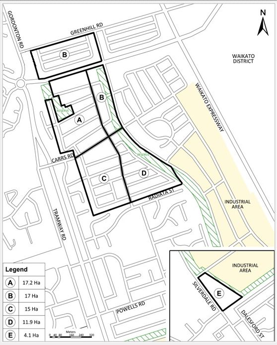
(a) The Medium-Density Residential Area is divided into a number of Comprehensive
Development Plan Areas (as shown in Figure 25H(3)).
(b) Development (except where identified in (b) below) in the Medium-Density
Residential Area can only occur once a resource consent for a Comprehensive
Development Plan for the entire Comprehensive Development Area has been
granted by Council.
(c) There are some activities that can occur as Permitted Activities with or without
an approved Comprehensive Development Plan, subject to compliance with
relevant standards in Rule 25H.7.5 Rule 4.6. These are:
i. Maintenance, repair and minor alterations or additions to
existing buildings (except scheduled heritage buildings).
ii. Informal recreation and ancillary buildings.
iii. Residential activities.
iv. Temporary activities.
v. Demolition or removal of existing buildings (except scheduled
heritage buildings).
25(a) If development is to be staged this must have been approved as part of the
resource consent application for the Comprehensive Development Plan.
(b) Unless otherwise stated, a Comprehensive Development Plan for each area
identified requires resource consent as a restricted discretionary activity.
(c) The activity status of Comprehensive Development Plan applications will be
classed as discretionary if one or more activities fail to meet one or more
standards in Rule 25H.7.5.
(d) The activity status of a Comprehensive Development Plan application will be
classified as non-complying if one or more activities that form part of the
application:
i. Are identified as a non-complying activity in the Activity Status
Table (refer to Rule 25H.7.2)
(a) In the absence of an approved Comprehensive Development Plan, all other
activities listed in Table 25H.7.2 are non-complying activities unless the activity is
listed as permitted in 25H.7.3.2c.
25H.7.3.3 Comprehensive Development Plan Areas
(a) The approximate location of Comprehensive Development Plan areas are
identified in Figure 25H(3) below. The boundaries of the Comprehensive
Development Plan areas may be altered as part of detailed design work for the
Comprehensive Development Plan application.
Figure 25H (3) Comprehensive Development Plan Areas
2625H.7.3.4 Contents of a Comprehensive Development Plan
An application for a Comprehensive Development Plan shall include the following:
(a) Site Development Information — showing topographic land contours, building
platforms and footprints, building subdivision including individual shop and
business tenancy sizes where practicable, pedestrian walkways, car parking
areas and vehicular circulation, vehicular access points between the site and
public roads, landscaped areas, and the position of adjacent properties in
terms of contributing to an overall urban design and streetscape character,
including treatment of building frontages.
(b) Development Controls — Demonstration of compliance or otherwise with the
Residential Area standards detailed in Rule 25H.7.5.
(c) Integrated Retail Development Car park Layout and Accessways — showing the
number of car parks to be provided, the layout and vehicle circulation within
the site, dimensions of car parks, carriageways and accessways, the provision of
landscape treatment and stormwater swales within the car park, and any
artificial lighting within these areas.
(d) Landscape Elements — showing the type of landscape treatment to be
provided in yards, car park areas, streets and other landscape areas and any
artificial lighting to be used in these areas. A landscape management plan shall
be included providing the identification of plant and tree species to be used,
the number of plants to be planted and plant spacings, appropriate garden
preparation techniques and the on-going management of the planting that is
proposed.
(e) Pedestrian Areas — showing the position of walkways, linkages to adjacent sites,
widths, angles of slope and paving materials proposed.
(f) Typical Elevations/Building Typologies — showing building exterior design
features including roofs, facades, verandahs, exterior building materials, colours
and finishes, and how the proposal integrates with adjacent properties in terms
of contributing to an overall urban design and streetscape character. The
information shall include an Architectural Code addressing key design
principles.
(g) Signage - showing the typology of external signs proposed on buildings
intended for non residential activities; and their placement and sizing controls.
25H.7.3.5 Notification Rule
Except as provided for by Section 95A(2)(b) and (c), 95B(2) and (3) and 95C(1)
to (4) of the Act, applications for any Restricted Discretionary Activity identified
with an asterisk(*) in the table above will be considered without notification or
the need to obtain approval from affected persons.
2725H.7.4 Assessment Criteria
25H.7.4.1 Controlled Activities: Matters of Control
(a) In determining any application for resource consent for a controlled activity in
addition to the relevant standards within Rules 25H.7.5 the Council shall reserves
its control over the following matters:
Activity Specific Matters of Control
i. Childcare facility for up to 1) Impact of building design,
five children external appearance and
configuration on the public
realm particularly when
viewed from open space
areas and arterial roads
2) Site layout
3) Landscaping
4) The extent to which the
amenity and safety of future
occupiers will be protected.
ii. Dairy 1) Impact of building design,
external appearance and
configuration on the public
realm particularly when
viewed from open space
areas and arterial roads
2) Site layout
iii. Integrated Retail 1) Impact of building design,
Development (Ruakura external appearance and
Comprehensive configuration on the public
Development Plan Area realm particularly when
only) viewed from open space
areas and arterial roads
2) Site layout
3) The extent to which the
proposal integrates with and
minimizes effects on the safe
and efficient functioning of the
transport network including the
Waikato Expressway and three
waters infrastructure.
iv. Community Centres 1) Impact of building design,
external appearance and
configuration on the public
realm particularly when
viewed from open space
areas and arterial roads
2) Site layout
28v. Relocated buildings 1) Impact of building design,
external appearance and
configuration on the public
realm particularly when
viewed from open space
areas and arterial roads
25H.7.4.2 Restricted Discretionary Activities: Matters for Discretion -
Comprehensive Development Plan
The Council will restrict its discretion to the matters listed, when considering resource
consent applications for Comprehensively Designed Development as a Restricted
Discretionary Activity.
25H.7.4.3 Restricted Discretionary Activities: Matters for Discretion
In addition to those matters specified for any non-compliance of development control
rules where applicable, the Council will restrict its discretion to the following matters:
(a) Building location, siting, scale, form and design including any signage.
(b) Landscape, planting and screening.
(c) Methods and design of water supply, sewage disposal and drainage.
(d) Land modification and earthworks.
(e) Location and design of roading, access, vehicle parking and circulation.
(f) Privacy and Open Space.
25H.7.4.4 Restricted Discretionary Activities: Assessment Criteria
When considering an application, in addition to those matters specified for any non-
compliance of development control rules where applicable, the Council will have
regard to the following criteria:
1. Building Scale form and Design
a. Whether there is variety in the street front elevations including
building articulation, and the use of varying materials and an
avoidance of blank or unrelieved walls.
b. Whether street frontages of houses provide potential for
surveillance of the street.
c. Whether garage(s) dominate the street frontage.
d. Whether the scale and physical extent of the proposal is
generally consistent with the scale of development expected
by the development controls.
e. Whether the building design and bulk have any adverse
effects on the public enjoyment of public open space
including the street.
29f. Whether building design and bulk have any adverse effects
on the provision of landscaping on the site, on neighbouring
sites or on the street.
2. Landscaping and Screening
(a) Whether the landscape works form part of a comprehensive
design concept which integrates building design and private,
communal and public land.
(b) Whether the landscape concept is appropriate to the urban and
natural context and to the creation of neighbourhood identity.
(c) Whether planting is used to:
i. establish and maintain a well vegetated environment
that is compatible with the neighbourhood and the
specific planting character of the street.
ii. visually reduce the bulk of new development and
integrate new buildings.
iii. help provide summer shade, wind breaks and access
to winter sun.
iv. help provide and maintain visual privacy.
v. create an attractive environment without prejudicing
personal safety.
(d) Whether existing mature trees, especially those located near
property boundaries, are practically able to be retained and
incorporated into the development.
3. Methods of water supply, sewage and stormwater management
(a) Whether adequate engineering and infrastructure services,
including the provision of stormwater treatment and drainage
infrastructure is provided for the stormwater treatment and
drainage needs of the development.
(b) Whether the management of stormwater flows is consistent with
any relevant Integrated Catchment Management Plan.
(c) Whether low impact design stormwater management principles
have been incorporated.
(d) Whether techniques are included to reduce sediment discharge
monitoring of sediment ponds, overall management of
earthworks and any future controls required for future subdivision
and / or small site earthworks in the precinct.
(e) Whether the development will adversely affect water quality.
(f) Whether the location of buildings will adversely affect the safe
and efficient operation including maintenance, of any utility or
network utility and whether access to such utilities can be
maintained at no significant additional expense.
304. Roading, access and vehicle parking
(a) Whether the layout of buildings and garages discourage cars
from parking across the footpath or verge.
(b) Whether the street network is well connected and achieves the
intent of the street network as shown on the Ruakura Structure
Plan
(c) Whether adequate provision is made for visitor car parking.
(d) Whether garage(s) dominate the street frontage and whether
parking is able to be concentrated at the rear of the
development via rear access.
(e) Whether adequate road access is provided, and no significant
adverse effects on the safety and efficiency of the public
roading network result.
5. Open Space
(a) Whether an adequate area of open space on the site suitable
for use and outlook by the occupants of each dwelling is
provided.
(b) Where open space on site cannot be provided, whether the
development has convenient access to communal open space
or a public reserve for the recreational benefit of future residents.
(c) Whether the arrangement of buildings and spaces on the site is
such that suitable spaces for the likely day to day outdoor
activities of residents are provided.
(d) Whether adequate levels of privacy are maintained within areas
of open space, between adjoining areas of open space and
between open space and other disassociated dwellings.
(e) Whether the open space receives adequate levels of sunlight.
(f) Whether the open space is appropriate to the type of housing
provided.
(g) Whether the open space is directly accessible to and part of the
associated household unit.
6. Visual Privacy
(a) Whether good levels of privacy are maintained within household
units.
7. Natural and cultural environment
(a) Whether any effects on sites of natural, archaeological or cultural
significance are avoided, remedied or mitigated.
3125H.7.4.5 Restricted Discretionary Activities: Matters for Discretion and
Assessment Criteria: Specified Activities
1. The extent to which the appearance, scale and design of buildings, site layout,
landscaping, on site infrastructure and parking areas make a positive
contribution to local character and streetscape amenity.
2. The extent to which the proposal would result in adverse effect to residential
amenity including privacy, noise and other disturbance.
3. The extent to which the proposal is consistent with any approved ICMP.
4. The extent to which the proposal would result in cumulative demand for non-
residential uses.
5. The extent to which the proposal integrates with and minimizes effects on the
safe and efficient functioning of the transport network including the Waikato
Expressway.
6. The extent to which the amenity and safety of future occupiers will be
protected, particularly in regards to noise and hazardous substances.
7. The extent to which the proposed development would result in reverse sensitivity
issues that could adversely affect the efficient functioning of the adjoining
areas.
25H.7.4.6 Restricted Discretionary Activities: Matters for Discretion and
Assessment Criteria: Specific Areas of Non-compliance with Rule 25H.7.5
1. The extent that any specific area of non-compliance will result in adverse
impacts on amenity, including shading, noise and visual dominance when
viewed from the public realm or residential properties.
2. The extent that any specific area of non-compliance will result in adverse
impacts on amenity of future occupiers.
3. The extent that any area of non-compliance will result in adverse effects on the
effective operation infrastructure (including water supply, wastewater and
stormwater networks).
25H.7.5 Rules – General Standards
25H.7.5.1 Comprehensive Development Plans
(a) All development in an area where the Council has granted consent to a
Comprehensive Development Plan shall comply with the terms of that consent.
25H.7.5.2 Height in Relation to Boundary
(a) Where a building is on land that adjoins the General Residential Area or a
Comprehensive Development Plan Area:
32i. No part of any building shall protrude through a plane rising at
an angle of 28 degrees between southnorthwest (315 225
degrees) and southnortheast (45 135 degrees), and rising at
an angle of 45 degrees in all other directions. This angle is
measured from 3m above ground level at all boundaries.
Except where:
i. Where buildings are attached, no setback is required between
those buildings.
ii. Written consent from the owners and occupiers of the
adjoining property is obtained.
25H.7.5.3 Residential Unit Size
(a) The minimum gross floor area required in respect of each residential unit shall
be:
Form of residential unit Gross floor area
i. Studio unit Minimum 45m2
ii. 1 bedroom unit Minimum 55m2
iii. 2 or more bedroom unit Minimum 80m2
25H.7.5.4 Permeable Surface
Medium Density Area
Permeability across the entire site Minimum 20%
25H.7.5.5 Noise and Vibration Standards
(a) Activities should also comply with any relevant noise and vibration rule in 25H.9.
25H.7.5.6 Staging
(a) Activities should also comply with any staging rule in 25H.10.
25H.7.6 Rules – Specific Standards
25H.7.6.1 Ancillary Residential Unit
(a) A maximum of one ancillary residential unit per site.
(b) Maximum gross floor area of 60m².
(c) The outdoor living area shall not be included as part of the outdoor living area
provided for the principal residential building on site.
25H.7.6.2 Childcare Facility
(a) The activity shall not be part of a multiple residential unit development.
(b) The activity shall be located on a front, corner or through site.
(c) The activity shall have a maximum gross floor area of all buildings of 250m2.
3325H.7.6.3 Community Centres, Tertiary and Specialised Training Facilities,
Schools and Places of Worship
a) Gross floor area of all Maximum 250m2
buildings
b) Hours of operation 0700 to 2200 hours
c) Additional hours for special 0000 to 0200 hours
religious observance
(maximum 1 per calendar
year)
25H.7.6.4 Dairies
a) Gross floor area of retail Maximum 100m2
b) Hours of operation 0700 to 2200 hours
c) Building setback from side or Minimum 5m
rear boundaries
25H.7.6.5 Home-based Businesses
(a) For the avoidance of doubt, if an activity does not comply with all of the
standards specified, it is not a home-based business. Home-based businesses
shall:
i. Not exceed 30% of the total gross floor area of buildings on the
site.
ii. Not generate any trips by a heavy motor vehicle.
iii. Not generate vehicle trips or pedestrian traffic between 2000
to 0800 hours.
iv. Not display any indication of the activity from outside the site
including the display or storage of materials, except for
permitted signs.
v. Retail only those goods which have been manufactured,
repaired, renovated or otherwise produced on the site.
vi. Not create electrical interference with television and radio sets
or other types of receivers in adjacent residential units.
vii. Not generate nuisances, including smoke, noise, dust,
vibration, glare, and other noxious or dangerous effects –
these shall be measured at the boundaries of the site.
25H.7.6.6 Managed Care Facilities
(a) Within one calendar month of its occupancy, the Agency/person(s) responsible
for the Managed Care Facility shall provide the residents of the properties
adjoining the site and Council’s Planning Department a written information
pack. The information pack shall include an overview of the Agency and the
range of services provided (if relevant), and the type of care and programs to
be provided within the Managed Care Facility and shall include the following.
34You can also read


