Residential Subdivision - 1830 Trim Road & 1141 and 1153 Brasseur Crescent - 1830 Trim Road & 1141 and 1153 ...
←
→
Page content transcription
If your browser does not render page correctly, please read the page content below

Residential Subdivision - 1830 Trim Road &
1141 and 1153 Brasseur Crescent
Planning Rationale/Design Brief/Integrated Environmental Review Statement (IERS)
Plan of Subdivision + Zoning By-law Amendment Applications
April 2, 2020
Prepared for Mattamy Homes

Prepared by Fotenn Planning + Design
396 Cooper Street, Suite 300
Ottawa, ON K2P 2H7

April 2020

© Fotenn
The information contained in this document produced by Fotenn is solely for
the use of the Client identified above for the purpose for which it has been
prepared and Fotenn undertakes no duty to or accepts any responsibility to
any third party who may rely upon this document.
1.0 INTRODUCTION                                                                        1
                  1.1     Application Summary                                                        1
                  1.2     Subject Lands                                                              3
                  1.3     Area Context                                                               4
                      1.3.1 Photos of Subject Lands                                                  5
                  1.4     Road, Cycling and Transit Network                                          6
                      1.4.1 Cycling Network                                                          6
                      1.4.2 Road Network                                                             7
                      1.4.3 Greater Transit Network                                                  8

             2.0 PROPOSED DEVELOPMENT                                                                9

             3.0 POLICY FRAMEWORK                                                                   13
                  3.1     Provincial Policy Statement (2014 and 2020)                               13
                  3.2     City of Ottawa Official Plan (2003, as amended)                           15
                      3.2.1 Section 2.2.2 – Managing Intensification within the Urban Area          15
                      3.2.2 Section 3.6.1 – General Urban Area Designation                          15
                      3.2.3 Section 3.3 – Major Open Space Designation                              16
                      3.2.4 Section 2.5.1 – Urban Design and Compatibility                          16
                      3.2.5 Section 4.11 – Urban Design and Compatibility                           17
                      3.2.6 Section 4.3 – Walking, Cycling, Transit, Roads and Parking Lots         21
                      3.2.7 Section 2.5.4 – A Strategy for Parks                                    22
                      3.2.8 Building Better and Smarter Suburbs                                     22
                      3.2.9 Urban Design Guidelines for Low-Rise Infill Housing (2012)              24
                  3.3     City of Ottawa Official Plan Review                                       26
                  3.4     City of Ottawa Comprehensive Zoning By-law (2008-250)                     26
                      3.4.1 Existing Zoning                                                         26
                      3.4.2 Proposed Zoning                                                         28

             4.0 INTEGRATED ENVIRONMENTAL REVIEW STATEMENT                                          31
                  4.1       Policy Context                                                          31
                  4.2       Summary of Technical Studies                                            33
                  4.3       Engineering Studies                                                     33
                        4.3.1 Geotechnical Investigation                                            33
                        4.3.2 Functional Servicing Report                                           33
                        4.3.3 Site Grading                                                          34
                        4.3.4 Roadway Traffic Noise Feasibility Assessment                          34
                        4.3.5 Transportation Impact Assessment                                      34
                  4.4       Planning Studies                                                        34
                        4.4.1 Planning Rationale/Design Brief/IERS                                  34
                  4.5       Environmental Studies                                                   35
                        4.5.1 Phase I Environmental Site Assessment                                 35
                        4.5.2 Phase II Environmental Site Assessment                                35
                        4.5.3 Tree Conservation Report                                              36
                  4.6       Potential Concerns, Mitigation Measures, and Implementation             36
                        4.6.1 Potential Concerns                                                    36
                        4.6.2 Mitigation Measures and Implementation of Commitments                 37
                  4.7       Design with Nature Principles and Design                                38
                  4.8       Energy Efficiency and Sustainable Design                                39
                  4.9       IERS Concurrence of Study Team                                          40

             5.0 CONCLUSION                                                                         41
April 2020
             6.0 Arcadis Canada Inc.             1830 Trim Road & 1141 and 1153 Brasseur Crescent   43
                                                 Planning Rationale/Design Brief/IERS
             7.0 Gradient Wind Engineers & Scientists                                               44
1.0
INTRODUCTION
Fotenn Consultants Inc. (“Fotenn”) has been retained by Mattamy Homes (“Mattamy”) to prepare a
Planning Rationale in support of Plan of Subdivision and Zoning By-law Amendment applications for
the lands legally known as Part of Lot ‘A’, Concession 9 and all of Blocks 176-180, Registered Plan 4M-
1217 and municipally known as 1830 Trim Road and 1141 and 1153 Brasseur Crescent in Ottawa’s
eastern community of Orl ans (“subject lands”).
1.1 Application Summary
A residential subdivision comprised of 111 townhouse units, the extension of an existing local street, one new
municipal park, a pathway connection, a servicing block, and lands to be added to an existing hydro corridor is
proposed for the subject lands. In order to permit the development as planned, applications for a Plan of
Subdivision and a Zoning By-law Amendment are required. The Plan of Subdivision application will establish
the lot and street layout, while the Zoning By-law Amendment application is required to rezone the site to
permit townhouse dwellings, the proposed municipal park, and the portion of the subject lands that is located in
the hydro corridor. More specifically, the following zones are proposed:
Residential Third Density Zone, Subzone YY, with Exceptions (R3YY[XXXX]) to permit the
development of 101 townhouses on the eastern extension of Winsome Terrace. The proposed
Exception would apply provisions that are unique to Mattamy’s products.
Residential Third Density Zone, Subzone Y, Exception 708 (R3Y[708]) to permit 10 townhomes
(two blocks of five units each) along Brasseur Crescent, which is consistent with the zoning of the
existing townhomes along Brasseur Crescent.
Parks and Open Space Zone (O1) to permit the development of the municipal park proposed in the
centre of the subdivision. The portion of the subject lands located within the hydro corridor is already
zoned O1 and is proposed to remain zoned O1.
The following studies and plans have been prepared in support of the concurrent Plan of Subdivision and
Zoning By-law Amendment applications:
Topographical Plan of Survey, prepared by J.D Barnes Limited, dated March 16th, 2020;
Draft Plan of Subdivision, prepared by J.D Barnes Limited, dated March 12th, 2020;
Concept Plan – 1830 Trim Road, Concept 8D, prepared by Korsiak Urban Planning, dated March 10th,
2020;
Building Elevations and Block Plans, prepared for Mattamy Homes, dated September 26 th, 2018;
Functional Servicing Report, Project No. 19-1137, prepared by David Schaeffer Engineering Ltd.
(DSEL), dated March 20 th, 2020, including:
- Grading Plan (Figure 2)
- Existing Conditions Plan (Drawing 1)
- Servicing Plan (Drawing 2)
- Profiles (Drawing 3)
- Sanitary Drainage Plan (Figure 3)
- Storm Drainage Plan (Figure 4)
Geotechnical Investigation, Report PG5083-1-Rev 2, prepared by Paterson Group, dated March 12th,
2020;
April 2020
1830 Trim Road & 1141 and 1153 Brasseur Crescent
Planning Rationale/Design Brief/IERS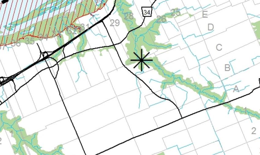
2
Phase 1 Environmental Site Assessment, prepared by Arcadis Canada Inc., dated August 1st, 2019;
Phase 2 Environmental Site Assessment, prepared by Arcadis Canada Inc., dated August 1st, 2019;
Record of Site Condition and Acknowledgement Letter from the Ministry of the Environment,
Conservation and Parks;
1830 Trim Road Archaeological Potential, prepared by Paterson Group, dated February 24th, 2020;
Transportation Impact Assessment, prepared by CGH Transportation, dated March 2020;
Roadway Traffic Noise Feasibility Assessment, Report 20-045, prepared by Gradient Wind Engineers
and Scientists, dated March 13th, 2020; and
Tree Conservation Report – 1830 Trim Road, prepared by Kilgour & Associates, March 17 th, 2020.
April 2020 1830 Trim Road & 1141 and 1153 Brasseur Crescent
Planning Rationale/Design Brief/IERS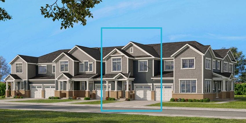
3
1.2      Subject Lands
The subject lands are located in the Cardinal Creek neighbourhood of Orl ans at the eastern end of the City of
Ottawa. The subject lands are located in the general area bound by Trim Road to the east and Valin Street to
the south and west (Figure 1). The northern edge of the subject lands is located within a hydro corridor
containing high voltage power lines, which is managed by Hydro One Networks Inc. via an easement over
privately-owned lands.

The subject lands have an area of 4.38 hectares, with approximately 0.74 hectares of this total area located
within the hydro corridor. The property municipally known as 1830 Trim Road has 22 metres of frontage at the
eastern terminus of Winsome Terrace while the properties municipally known as 1141 and 1153 Brasseur
Crescent have a combined frontage of approximately 106 metres along Brasseur Crescent. The subject lands
no longer have frontage along Trim Road as it was realigned sometime between 2011 and 2014. The existing
vehicular access from Trim Road, over City-owned lands (the former Trim Right-of-Way (ROW)), to 1830 Trim
Road will be closed.

The subject lands are generally flat and were formerly used as a school bus maintenance and storage yard,
including a one-storey maintenance garage/offices located in the southwestern corner of 1830 Trim Road.
Approximately two-thirds of the subject lands is hard surfaced, with the eastern portion maintained with
vegetation. The northern property line is treed to provide a buffer between former bus maintenance yard and
the Multi-Use Pathway (MUP) located within the hydro corridor.

Figure 1: Site Context Map

April 2020                                                     1830 Trim Road & 1141 and 1153 Brasseur Crescent
                                                               Planning Rationale/Design Brief/IERS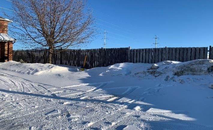
4
1.3      Area Context
The following land uses are located in the area surrounding the subject lands:

NORTH:
The northwestern edge of the subject lands forms part of a hydro corridor which is approximately 90 metres in
width and acts as a green corridor running northeast/southwest through Orléans. There is an existing MUP
within the hydro corridor which is accessible from adjacent neighbourhoods via various pathway blocks and
intersecting streets.

Further northwest of the hydro corridor is the Fallingbrook neighbourhood, beyond which is Highway 174. A
Light Rail Transit (LRT) corridor with four Orléans stations is expected to be constructed in the centre of
Highway 174 by 2024. The eastern most LRT station is planned for the northern terminus of Trim Road, where
there is an existing Bus Rapid Transit (BRT) station and an associated park and ride .

The Ottawa River and associated features (such as the Petrie Island wetlands) are located approximately 3
kilometres to the north of the subject lands and provide recreational opportunities such as beaches and
recreation trails.

Approximately 3 kilometres northwest of the subject lands is the Orléans Town Centre/Mixed Use Centre,
which accommodates a wide range of such uses as a regional shopping centre, the Shenkman Arts Centre, a
YMCA, a movie theatre, and a range of restaurants, retail stores, and service commercial uses. Approximately
4 kilometres northwest of the subject lands is the start of the St. Joseph Arterial Mainstreet, which is
characterized by institutional, restaurant, retail store, and service commercial uses and continues west to
Youville Drive/Forest Valley Drive.

The northeastern corner of the subject lands abuts the former Trim Road ROW, which remains undeveloped.
The existing driveway from the subject lands, over the former ROW to realigned Trim Road will be closed,
removing any vehicular connection from the proposed subdivision to Trim Road. North of Trim Road is the
Cardinal Creek Community Park, a large community park which includes amenities such as a splash pad,
outdoor rink, bench fit, sports fields, and play structures.

EAST:
Immediately east of the subject lands are the rear yards of existing townhomes that front onto Destiny Private,
which were constructed in 2007/2008. Further east of the subject lands is Trim Road, an arterial road which
provides north-south vehicular movement through Orléans, with a connection to Highway 174 to the north.
Further east is Cardinal Creek, beyond which is the Rural Area.

SOUTH AND WEST:
To the immediate south of the subject lands are the rear yards of townhomes fronting onto Brasseaur Crescen t,
which were constructed in 2006/2007. Immediately west of the subject lands is the existing eastern terminus of
Winsome Terrance, a municipal local road which is characterized by existing townhomes fronting on the north
side and the corner side yards of largely detached homes on the south side.

Further south and west of the subject lands are low-density residential neighbourhoods comprised primarily of
two-storey detached and townhouse dwellings. The majority of these neighbourhoods were developed between
2000 and 2005.

Further to the southwest of the subject lands, at the corner of Valin Street and Provence Avenue, is Maple
Ridge Elementary School, which accommodates approximately 530 students ranging from Junior Kindergarten
to Grade 8.

April 2020                                                      1830 Trim Road & 1141 and 1153 Brasseur Crescent
                                                                Planning Rationale/Design Brief/IERS
5
Approximately 2.5 kilometres to the southwest of the subject lands is the Innes Road Arterial Mainstreet, a road
characterized by commercial and retail uses that serve the daily needs of the residents of the area. The
Mainstreet, which includes retail food stores, restaurants and other retail and service commercial uses,
commences at Tenth Line Road and ends at Pagé Road.

1.3.1        Photos of Subject Lands

Figure 2 and 3 are photos of the subject lands that were taken on February 20, 2020.

Figure 2: Left: Existing building, Right: Existing building with rear of townhomes along Brasseur Crescent beyond

Figure 3: Left: Looking northeast from subject lands towards hydro corridor, Right: Fence at east end of Winsome Terrace, subject lands
beyond

April 2020                                                                     1830 Trim Road & 1141 and 1153 Brasseur Crescent
                                                                               Planning Rationale/Design Brief/IERS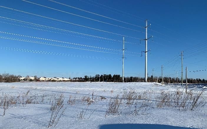
6
1.4      Road, Cycling and Transit Network
1.4.1 Cycling Network
The subject lands are located within close proximity to a cross-town bikeway (Innes Road), cycling spine routes
(Innes Road and Trim Road), and a MUP (in the hydro corridor, which connects to MUPs along Cardinal Creek
to the east) as identified on Schedule C – Primary Urban Cycling Network of the Official Plan (Figure 4). The
proposed development will link to the MUP within the hydro corridor via a pathway block (Block 22 on the Draft
Plan of Subdivision) from the proposed eastern extension of Winsome Terra ce.

Figure 4: Excerpt from Schedule C- Primary Urban Cycling Network

April 2020                                                         1830 Trim Road & 1141 and 1153 Brasseur Crescent
                                                                   Planning Rationale/Design Brief/IERS
7
1.4.2 Road Network
As per Schedule E- Urban Road Network of the Official Plan, the subject lands are located in proximity to an
existing arterial road (Trim Road), which has been realigned. Windsome Terrace is categorized as a local road,
which connects to Valin Street (an existing collector), which connects to the greater street grid through Trim
Road and Portobello Boulevard.

Figure 5: Schedule E - Urban Road Network

April 2020                                                     1830 Trim Road & 1141 and 1153 Brasseur Crescent
                                                               Planning Rationale/Design Brief/IERS
8
1.4.3 Greater Transit Network
As shown in Figure 6, the subject lands are located within 400 metres of Bus Route #39, which transports
users along Trim Road between the Millennium BRT station to the south of Innes Road, north to the Trim BRT
station at Highway 174, and then west along Highway 174 to the LRT station at Blair. The subject lands are
also served by a variety of local bus routes along Valin Street, Portobello Boulevard, and Innes Road, which
ultimately connect to the greater transit system.
Figure 6: OC Transpo Simplified Network Map (Approximate Site Location Shown by Blue Star)
April 2020 1830 Trim Road & 1141 and 1153 Brasseur Crescent
Planning Rationale/Design Brief/IERS9
2.0
PROPOSED DEVELOPMENT
Vehicular access to the development will be provided through an eastward extension of Winsome Terrace,
which will form a ‘p’-loop within the proposed Plan of Subdivision (Figure 7). Mattamy intends to develop the
subject lands with a total of 111 townhouse dwellings configured in blocks of 4 to 6 townhomes (Figure 8). Two
rows of five townhomes (ten units total) will front onto Brasseur Crescen t while the remainder will front onto the
eastern extension of Winsome Terrace (‘P’- loop). Townhome units vary from 1,446 m 2 to 1,768 m2 in floor
area, depending on the model, all of which are 3-bedroom units. The typical townhome lot width is
approximately 6.4 metres, with the lot depths ranging from 26 to 31 metres. With a net area of 2.25 hectares, a
density of 49.3 units/net hectare is proposed. Each townhome unit will have a driveway leading to a garage,
where the required parking space will be located.
The proposed development will also include:
A centrally located 0.379 hectare municipal park (Block 23);
Hydro corridor lands (subject to an existing Hydro One Networks Inc. easement) that will be dedicated
to the City (Block 24);
A 6-metre wide pathway/servicing block (Block 22) between Winsome Terrace and the hydro corridor,
in order to provide a pedestrian/cyclist connection between the proposed subdivision and the existing
MUP within the hydro corridor; and
A 6-metre wide servicing block (Block 21) in the southeastern corner of the subdivision, which will allow
for a connection to the existing water infrastructure in the Trim Road ROW.
The following table identifies the proposed land uses and the associated block numbers and areas:
Table 1. Proposed Land Uses
Land Use Block(s) Area (square metres)
Townhouse blocks 1 to 20 (inclusive) 22,484.0
Servicing block 21 239.2
Pathway/servicing block 22 146.2
Park 23 3793.7
Hydro corridor 24 7373.3
Street Winsome Terrace 9718.6
Total 43,755.0
April 2020 1830 Trim Road & 1141 and 1153 Brasseur Crescent
Planning Rationale/Design Brief/IERS10
Figure 7: Excerpt from Draft Plan of Subdivision
April 2020 1830 Trim Road & 1141 and 1153 Brasseur Crescent
Planning Rationale/Design Brief/IERS11
Figure 8: Concept Plan
Schools and Parkland
The subject lands are located within an established neighbourhood which is served by the following existing
schools:
Maple Ridge Elementary School (Ottawa Carleton District School Board (OCDSB))
Béatrice-Desloges Catholic High School (Conseil des écoles catholiques du Centre-Est (CECCE))
St. Clare School (Ottawa Catholic District School Board (OCSB))
St. Peter High School (OCSB)
Catholic Elementary School des Pionniers (CECCE)
Trillium Elementary School (OCDSB)
April 2020 1830 Trim Road & 1141 and 1153 Brasseur Crescent
Planning Rationale/Design Brief/IERS12
The proposed 0.379 hectare municipal park is classified a Parkette in the City’s Park Development Manual
(2017). As suggested in the Manual, the Parkette will have two street frontages (north and south portions of the
Winsome Terrace ‘P’-loop) and will link to the broader greenspace network through the proposed pathway
block (Block 22) to the hydro corridor, which is located immediately opposite the Parkette.
Roads and Pathways
As previously mentioned, the proposed subdivision will be accessed via an eastward extension of Winsome
Terrace, which is an existing local road. The proposed right-of-way (ROW) width for the eastward extension is
18 metres, save for the single-loaded portion of the street in the northeast corner of the subject lands, which
will have a ROW width of 14.75 metres. The transition from a 20 metre ROW (existing portion of Winsome
Terrace) to an 18 metre ROW (proposed extension) will not affect the user experience given that:
The pavement width will remain consistent (8.5 metres)
The lot depths of the existing townhome lots on the north side of Winsome Terrace will align with the lot
depths of the proposed townhomes (before the street jogs north slightly)
There will continue to be street trees on both sides of Winsome Terrace
There will continue to be no sidewalks on either side of Winsome Terrace
In order to allow for pedestrian and cyclist access to the existing MUP in the hydro corridor, a 6-metre wide
pathway block is proposed in the Draft Plan of Subdivision between Winsome Terrace and the hydro corridor.
Site Servicing
The existing underground well and septic tank will be decommissioned prior to the construction of the proposed
subdivision. As the subject lands are located within an established neighbourhood, water, wastewater, and
sanitary services are available within the immediate vicinity. The proposed subdivision will connect to existing
municipal servicing infrastructure through:
Winsome Terrace (sanitary and water);
Brasseur Crescent (the ten townhome units proposed to front along this street);
The hydro corridor via Block 22 (stormwater); and
Trim Road via Block 21 (water).
The subject lands are under the jurisdiction of the Rideau Valley Conservation Authority (RVCA).
April 2020 1830 Trim Road & 1141 and 1153 Brasseur Crescent
Planning Rationale/Design Brief/IERS13
3.0
POLICY FRAMEWORK
3.1 Provincial Policy Statement (2014 and 2020)
The Provincial Policy Statement (PPS), which was issued under Section 3 of the Planning Act in 2014, provides
policy direction on matters of provincial interest related to land use planning and development. Policies within
the PPS address such matters as building strong healthy communities, the wise use and management of
resources, and protecting public health and safety. The Planning Act requires that decisions affecting planning
matters “shall be consistent with” policy statements issued under the Act.
Section 1.1 of the PPS addresses managing and directing land use to achieve efficient and resilient
development and land use patterns, including sustaining healthy, liveable and safe communities by:
Promoting efficient development and land use patterns which sustain the financial well-being of the
Province and municipalities over the long term;
Accommodating and appropriate range and mix of residential, institutional, recreation, park and open
space, and other uses to meet long-term needs;
Avoiding development and land use patterns which may cause environmental or public health and
safety concerns;
Avoiding development and land use patterns that would prevent the efficient expansion of settlement
areas in those areas which are adjacent or close to settlement areas;
Promoting cost-effective development patterns and standards to minimize land consumption and
servicing costs;
Improving accessibility for persons with disabilities and older persons by identifying, preventing and
removing land use barriers which restrict their full participation in society;
Ensuring that necessary infrastructure, electricity generation facilities and transmission and distribution
systems, and public service facilities are or will be available to meet current and projected needs; and
Promoting development and land use patterns that conserve biodiversity and consider the impacts of a
changing climate.
Further to the above policies, Section 1.1 states that sufficient land shall be made available to accommodate an
appropriate range and mix of land uses to meet projected needs for a time horizon of up to 20 year s, with
sufficient land made available through intensification and redevelopment, and if necessary, designated growth
areas.
Section 1.1.3 identifies settlement areas as the focus of growth and development, with land use patterns in
settlement areas to be based on:
Densities and a mix of land uses which:
o Efficiently use land and resources;
o Are appropriate for, and efficiently use, the infrastructure and public service facilities which are
planned or available, and avoid the need for their unjustified and/or uneconomical expansion;
April 2020 1830 Trim Road & 1141 and 1153 Brasseur Crescent
Planning Rationale/Design Brief/IERS14
o Minimize negative impacts to air quality and climate change, and promote energy efficiency;
o Support active transportation;
o Are transit-supportive, where transit is planned, exists or may be developed; and
o Are freight-supportive.
A range of uses and opportunities for intensification and redevelopment, where this can be
accommodated taking into account existing building stock or areas, including brownfield sites, and the
availability of suitable existing or planned infrastructure and public service facilities required to
accommodate projected needs
Section 1.5 of the PPS addresses parks and open space and includes policies to promote healthy and active
communities by planning and providing for a full range and equitable distribution of publicly-accessible built and
natural settings for recreation, including facilities, parklands, public spaces, open space areas, trails and
linkages.
Finally, Section 1.6 of the PPS provides policies for infrastructure and public service facilities. Policies speak to
directing growth in a manner that optimizes the use of existing infrastructure and public service facilities,
including municipal sewage and water services.
On May 1, 2020, a revised version of the PPS will come into full force and effect. Some of the applicable
revisions to the PPS include:
Policy 1.1.1 is revised to specify that healthy, liveable and safe communities are sustained by:
o Accommodating an appropriate affordable and market-based range and mix of residential
types
o Promoting the integration of land use planning, growth management, transit-supportive
development, intensification and infrastructure planning to achieve cost-effective
development patterns, optimization of transit investments, and standards to minimize land
consumption and servicing costs;
o Improving accessibility for persons with disabilities and older persons by addressing land use
barriers which restrict their full participation in society;
o Preparing for the regional and local impacts of a changing climate
Policy 1.1.2 now states that sufficient land shall be made available to accommodate an appropriate
range and mix of land uses to meet projected needs for a time horizon of up to 25 years.
Policy 1.1.3.2 (which speaks to densities and a mix of land uses that land use patterns within
settlement areas shall be based on) now includes “prepare for the impacts of a changing climate”.
The proposed development is consistent with the policies of the PPS as it provides new opportunities
and choices for housing within an area currently serviced by infrastructure, including municipal water,
stormwater, and sanitary servicing, schools, roads, transit, and open space. New parkland will be
dedicated to the City and constructed as part of the proposed development, increasing parkland in the
neighbourhood and supporting healthy communities.
April 2020 1830 Trim Road & 1141 and 1153 Brasseur Crescent
Planning Rationale/Design Brief/IERS15
3.2 City of Ottawa Official Plan (2003, as amended)
3.2.1 Section 2.2.2 – Managing Intensification within the Urban Area
The Official Plan supports intensification within the Urban Area, including but not limited to:
“The development of vacant or underutilized lots within previously developed areas, being defined as adjacent
areas that were developed four or more years prior to new intensification.”
The subject lands are not located in a target intensification area, which includes Central Area, Mixed Use
Centres, Mainstreets, and Town Centres. However, policy 22 in Section 2.2.2 states that the City will support
intensification outside of target intensification areas, including in the General Urban Area, in particular where it
will enhance and complement its desirable characteristics and long-term renewal.
Policy 10 in Section 2.2.2 acknowledges that intensification may occur in a variety of built forms, from low-rise
to high-rise, provided urban design and compatibility objectives are met and notes that low -rise intensification
will be the predominant form of intensification in the General Urban Area designation.
The proposed plan of subdivision provides an opportunity to increase the number of residents living within
proximity of existing schools, parks, and transit routes and maximize the use of existing municipal
infrastructure. The additional residents will also serve to support the two Arterial Mainstreets (Innes Road and
St. Joseph Boulevard) and the Town Centre in Orléans, contributing to their viability.
3.2.2 Section 3.6.1 – General Urban Area Designation
The subject lands are largely designated “General Urban Area” on Schedule B- Urban Policy Plan of the
Official Plan (Figure 9). The General Urban Area designation permits a wide variety of uses, including a full
range and choice of housing types to meet the needs of all ages, incomes and life circumstances . Townhomes
are a permitted use in the General Urban Area. Generally, uses that have the potential for negative impacts,
such as noise, traffic, or lighting, are directed to locate at the edges of communities.
As noted previously, building heights in the General Urban Area are expected to be predominantly low-rise
(four storeys or less), with taller buildings permitted in select locations, such as fronting on arterial roads and in
proximity to transit or in areas already characterized by taller buildings.
The Official Plan supports intensification within the General Urban Area where it will complement the existing
pattern and scale of development and planned function of the area. In reviewing applications for intensification,
the City will:
Assess the compatibility of new development as it relates to existing community character so that it
enhances and builds upon desirable established patterns of built form and open spaces and
Consider its contribution to the maintenance and achievement of a balance of housing types and
tenures to provide a full range of housing for a variety of demographic profiles throughout the General
Urban Area.
The proposed development meets the policies of the General Urban Area designation as it fulfills
intensification policies in a manner which is compatible with the existing residential neighbourhood.
More specifically, the proposed 2-storey townhomes will be compatible with the existing 2-storey
townhomes along Winsome Terrace, Brasseur Crescent, and Destiny Private and the proposed
municipal park will contribute to the amount of available parkland in the broader area.
April 2020 1830 Trim Road & 1141 and 1153 Brasseur Crescent
Planning Rationale/Design Brief/IERS16
Figure 9: Excerpt from Schedule B - Urban Policy Plan
3.2.3 Section 3.3 – Major Open Space Designation
The existing hydro corridor is designated “Major Open Space” on Schedule B- Urban Policy Plan. This
designation represents key components of the Greenspace Network and are generally publicly owned. These
open spaces contribute to the quality of life in neighbouring communities as well as to the overall integrity of the
natural environment.
3.2.4 Section 2.5.1 – Urban Design and Compatibility
Section 2.5.1 of the Official Plan contains design objectives that are intended to be applied to new
development. The design objectives of Section 2.5.1 are met by the proposed plan of subdivision in the
following ways:
Enhance the sense of community by creating and maintaining places with their own distinct identity
The proposed subdivision makes more efficient use of an underutilized lot in an existing suburban
neighbourhood. The subdivision will contribute to the sense of community through the provision of new
opportunities for recreation through the development of a new municipal park and a proposed connection to the
MUP located within the hydro corridor.
Define quality public and private spaces through development
The proposed public spaces, including the extension of an existing tree-lined municipal street, a pathway block
to an existing green corridor, and a programmed municipal park, will serve to connect the proposed private
spaces (townhome lots).
April 2020 1830 Trim Road & 1141 and 1153 Brasseur Crescent
Planning Rationale/Design Brief/IERS17
Create places that are safe, accessible and are easy to get to, and move through
The proposed ground-oriented, street-fronting units will contribute to a pleasant pedestrian realm and will also
provide “eyes” on the street, increasing actual and perceived safety. The pathway block to the hydro corridor is
aligned with the municipal park and has access to a municipal street, allowing for an accessible route between
existing and proposed units and the components of the greenspace network.
Ensure that new development respects the character of existing areas
The proposed built form (townhomes) is compatible with the existing townhomes and detached homes found in
the immediately surrounding area.
Consider adaptability and diversity by creating places that can adapt and evolve easily over time and
that are characterized by variety and choice
The proposed subdivision is representative of evolution that can occur over time in communities.
The proposed townhouse units will allow existing residents within the broader area to continue to live within the
community as they move through their lifecycle.
Understand and respect natural processes and features in development design
Given the previous use, the subject lands have limited natural features. As outlined in the Tree Conservation
Report prepared by Kilgour & Associates (March 17, 2020), there are no significant natural heritage areas
(Significant Woodlands, Valley Lands or Wetlands, no watercourses other than road side ditches, ANSIs, Urban
Natural Areas) or areas indicated as having potential natural heritage significance located within 120 metres of
the subject lands.
Maximize energy-efficiency and promote sustainable design to reduce the resource consumption,
energy use, and carbon footprint of the built environment.
The proposed subdivision is considered infill development, which will add more residents within an existing
urban serviced area. More specifically, the proposed density (49.3 units/net hectare) well exceeds the minimum
density of 34 units/net hectare that is required in the Official Plan for new Greenfield development outside of
the Greenbelt. As such, the proposed subdivision will result in more efficient use of existing urban land and
existing infrastructure, such as pipes, roads, transit, schools, and parkland.
A large amount of open space is proposed in the subdivision, including landscaped front, rear, and side yards
on each lot, the hydro corridor, and the proposed municipal park. These pervious , landscaped areas should
minimize microclimate impacts and allow for water infiltration.
3.2.5 Section 4.11 – Urban Design and Compatibility
Section 4.11 addresses issues of urban design and compatibility. The following policies are applicable to the
subject lands and have been evaluated with respect to the proposed subdivision.
Table 2: Urban Design and Compatibility Criteria of Section 4.11 of the Official Plan
Policies Proposed Subdivision
Views The Official Plan does not designate any protected views in proximity to the subject lands.
Given the low-rise nature of the proposed subdivision, the subdivision will not impact the
existing skyline.
Building All units are proposed to front directly onto a municipal street, which maintains the cha racter
Design of the existing streetscape along Winsome Terrace and Brasseur Crescent.
The proposed townhome elevations exhibit a gable roof, similar to the existing townhomes in
the immediate area (Figures 10 through 14).
April 2020 1830 Trim Road & 1141 and 1153 Brasseur Crescent
Planning Rationale/Design Brief/IERS18
Policies Proposed Subdivision
The elevations proposed by Mattamy improve upon the existing streetscape by accentuating
the front entrances (and living space above). More specifically, the front entrances project
slightly beyond the garages, making the front entrances the prominent features on the front
facades as opposed to the garages.
Townhome blocks will either have a craftsman elevation (more traditional) or a transitional
elevation (more modern). The proposed cladding materials are siding, masonry, and wood
shingles (craftsman elevations).
Massing and The proposed lot width (5.5 metres) is similar to the lot widths of the existing zoning of the
Scale townhomes to the immediate south and east of the subject lands (6 metres).
The proposed development is proposed to be zoned for a maximum height of 14 metres,
which is compatible with the zoning of the existing low-rise neighbourhoods to the immediate
south and east (11 metres).
The proposed front yard setback of 4.25 metres does not vary significantly from the zoning to
the immediate south and east (5 and 6 metres).
Given that the proposed development will consist only of low-rise dwellings, no concerns
related to massing and scale, such as privacy, overlook, or shadowing, are expected.
Outdoor Similar to the existing townhomes in the area, each of the proposed townhomes will have a
Amenity rear yard. A minimum rear yard setback of 6 metres is proposed, which is appropriate and
Areas compatible with the zoning of the existing townhomes in the area (6 and 6.5 metres).
As outlined in Table 2 above, the proposed development is compatible with the existing
neighbourhood.
April 2020 1830 Trim Road & 1141 and 1153 Brasseur Crescent
Planning Rationale/Design Brief/IERS19
Figure 10. Oak model, craftsman elevation
Figure 11. Pristine corner, transitional elevation
April 2020 1830 Trim Road & 1141 and 1153 Brasseur Crescent
Planning Rationale/Design Brief/IERS20
Figure 12. Sample townhome block front elevation
Figure 13. Left side elevation of townhome block in Figure 12
April 2020 1830 Trim Road & 1141 and 1153 Brasseur Crescent
Planning Rationale/Design Brief/IERS21
Figure 14. Right side elevation of townhome block in Figure 12
3.2.6 Section 4.3 – Walking, Cycling, Transit, Roads and Parking Lots
Policies addressing connectivity through walking, cycling, transit and roads are detailed in Section 4.3 of the
Official Plan. These policies address a number of aspects including active transportation, parking structures,
sidewalks, and cycling facilities, among others. Policies applicable to the subject lands and the proposed
development include the following:
The City will require that new plans of subdivision and other developments include adequately spaced
inter-block/street cycling and pedestrian connections to facilitate travel by active transportation.
The proposed subdivision will provide pedestrian access to the existing MUP to the north of the subject
lands, within the hydro corridor.
April 2020 1830 Trim Road & 1141 and 1153 Brasseur Crescent
Planning Rationale/Design Brief/IERS22
3.2.7 Section 2.5.4 – A Strategy for Parks
Section 2.5.4 outlines a strategy for parks, including policies that addre ss park linkages, targets for the urban
area, and general characteristics to be included within their construction. Specifically, Policy 4 states that “new
parks provided in urban areas will have the following characteristics:
Contribute to the equitable distribution of these areas within the community;
Be easily accessible by foot or by bicycle from homes and linked to other greenspaces;
Are visible from many vantage points within the community;
Have significant street frontage, in property to their size, often fronting on two or more streets
depending on their space and function; and
Designed to be engage and useful spaces for people across a wide spectrum of age, socio -economic
demographics and recreational interests.”
Through the plan of subdivision, a new 0.379 hectare municipal park will be constructed. The park will
be accessible by residents of the both the proposed development and the existing neighbourhood and
will have frontage on two municipal streets. Mattamy will work with the City to ensure that the design of
the new park accommodates facilities that are needed in the broader area.
3.2.8 Building Better and Smarter Suburbs
The City launched the Building Better and Smarter Suburbs (BBSS) initiative in the fall of 2 013. The intent of
the study is to identify challenges associated with new, dense suburban communities and to develop solutions
to resolve these issues and conflicts. Completed BBSS Initiatives include the following:
Arterial Road Cross-Sections and Collector Road Cross-Section guidelines: Neither apply to the
proposed plan of subdivision as Winsome Terrace is a local street.
Traffic Calming and Pedestrian Priority Measures: The proposed plan of subdivision facilitates active
transportation through neighbourhood connections.
Updated Park Development Manual (2017): The manual will be applied in the design of the proposed
municipal park.
Mini-Roundabout Guidelines: There are no mini-roundabouts proposed in the subdivision.
Pedestrian Crossovers information for new subdivisions: Pedestrian crossovers will be evaluated
through detailed design of the subdivision.
Tree Planting in Sensitive Marine Clay Soils: The guidelines are currently being reviewed by the City of
Ottawa, a draft version of the 2020 guidelines are not available. As such, the 2017 guidelines have
been used for this development.
On March 10, 2015, Planning Committee approved the report titled “Building Better and Smarter Suburbs
(BBSS): Strategic Directions and Action Plan” (dated February 20, 2015), which aims to support land efficiency
and functionality in new suburban subdivisions. The Vision for the BBSS initiative is “the principles of good
urbanism should apply to the suburbs as they do to other parts of the City.” This Vision is supported by four
principles which speak to Ottawa’s suburbs being: land efficient and integrated; easy to walk, bike, bus, or
drive; well designed; and financially sustainable.
April 2020 1830 Trim Road & 1141 and 1153 Brasseur Crescent
Planning Rationale/Design Brief/IERS23
The following nine core topic areas are identified in the BBSS document, each of which has its own objectives,
strategic directions, and action plan:
Street Network and Land Use
Parks and Open Space
Stormwater Management
School Sites
Parking
Road Rights-of-Way
Rear Lanes
Trees
Utility Placement
The following table identifies the BBSS Strategic Directions that are met in the proposed subdivision.
Table 3: BBSS Strategic Directions
BBSS Core Strategic Direction Proposed Subdivision
Topic Area
Street Design the street network as an integral part The subdivision plans for the eastern
Network and and extension of the municipal grid, taking extension of Winsome Terrace, an existing
Land Use into consideration its future adjustments and local street.
evolution.
Design the street network based on a Given that Winsome Terrace is a local street,
modified or offset grid to maximize choices of the extension is proposed as a P-loop as
travel routes and opportunities for utility opposed to a connection to Trim Road, an
connections. arterial road, to the east.
and Sidewalks are not proposed in order to be
consistent with the character of the existing
Design the street network in conjunction with portion of Winsome Terrace, which does not
the land use and open space system to have sidewalks.
ensure direct pedestrian and cyclist
connectivity to key destinations in the A pathway block is proposed from Winsome
community (schools, shops, bus stops and Terrace north to the hydro corridor in order to
stations, etc.). provide pedestrian and cyclist connections to
the existing MUP.
and
Ensure that a range of appropriate sized
roadways complements the character and
functional needs of each community area.
Avoid reverse frontage lots (rear yards No rear lotting is proposed.
abutting public streets) within the community
Parks and Create street and lot patterns and building A central municipal park is proposed with
Open Space orientations that frame and enhance the frontages on both the north and south
presence of all parks, regardless of size. portions of the Winsome Terrace ‘P’-loop.
and A pathway block is proposed directly
opposite the municipal park in order to
April 2020 1830 Trim Road & 1141 and 1153 Brasseur Crescent
Planning Rationale/Design Brief/IERS24
BBSS Core Strategic Direction Proposed Subdivision
Topic Area
Identify opportunities to connect separate connect with the broader greenspace
features of the open space network (e.g. a network in the area (hydro corridor with
park to a nearby woodlot) with streets that MUP).
support canopy trees.
Stormwater Ensure that land attributed to large SWM While not a stormwater management facility,
Management facilities can serve additional functions, such the abutting hydro corridor, which has an
as recreation trails or multi-use paths as part existing MUP that the proposed subdivision
of the open space system, and support the will connect to, provides for a connected
connection of trails in SWM facilities to parks greenspace network.
and open spaces, and to pedestrian and
cycling facilities.
Road Right- ROW cross-sections, roadway widths, and Despite the existing stretch of Winsome
of-Way design speeds should respond to built form Terrace having a 20 metre ROW, an 18
and land use context. metre ROW is proposed for the eastern
extension in order to make more efficient use
of land.
Ensure components of a `complete street` The proposed ROW design of the eastern
are provided in the ROW, such as: extension of Winsome Terrace is reflective of
the existing portion of Winsome Terrace,
-Pedestrian facilities which does not have dedicated pedestrian or
-Cycling facilities cyclist facilities.
-On-street parking;
-Traffic calming features; Street trees and utility placements will be
-Trees on both sides of the street, including addressed at detailed design (subdivision
canopy trees; registration).
-Utility placement and operational
considerations that do not interfere with the
attributes of complete streets.
3.2.9 Urban Design Guidelines for Low-Rise Infill Housing (2012)
The City’s Urban Design Guidelines for Low Rise Infill Housing are a series of design guidelines to manage the
design of infill housing on vacant lots in established urban areas. Infill optimizes the efficient use of serviced
lands adjacent to existing infrastructure and transportation modes. Design guidelines are a working tool to help
developers, designers, property owners, utility providers, community groups, builders, Council and City staff
implement policies of the Official Plan and facilitate the approvals proce ss by highlighting the desired type of
development.
The guidelines have targets and attributes that guide the development of streetscapes, landscape, building
design, parking and service elements. The following guidelines apply to the proposed subdivision:
Contribute to an inviting, safe, and accessible streetscape by emphasizing the ground floor and street
façade of infill buildings. Locate principal entries, windows, porches and key internal uses at street
level.
Reflect the desirable aspects of the established streetscape character.
Expand the network of public sidewalks, pathways and crosswalks, to enhance pedestrian safety .
April 2020 1830 Trim Road & 1141 and 1153 Brasseur Crescent
Planning Rationale/Design Brief/IERS25
Provide pedestrian-scale lighting that points downward in order to minimize light pollution and prevent
spillage onto neighbouring properties.
Design accessible walkways, from private entrances to public sidewalks.
Provide street trees in continuous planting pits or in clusters to support healthy growth. Where the
available soil volume and planting area is limited (less that 9 m2 per tree), use materials and planting
techniques (e.g. permeable paving, Silva Cells or similar planting systems) that improve tree growth
conditions and limit the impacts of soil compaction and road salt. Plant trees, shrubs, and ground cover
adjacent to the public street and sidewalk for an attractive sidewalk edge. Select hardy, salt-tolerant
native plant material that can thrive in challenging urban conditions
Ensure new infill faces and animates the public streets. Ground floors with principal entries, windows,
porches and key internal uses at street level and facing onto the street, contribute to the animation,
safety and security of the street
Locate and build infill in a manner that reflects the existing or desirable planned neighb ourhood pattern
of development in terms of building height, elevation and the location of primary entrances, the
elevation of the first floor, yard encroachments such as porches and stair projections, as well as front,
rear, and side yard setbacks.
Orient buildings so that their amenity spaces do not require sound attenuation walls and that noise
impacts are minimized. Design amenity areas such as second floor balconies and roof top decks to
respect the privacy of the surrounding homes
Maintain rear yard amenity space that is generally consistent with the pattern of the neighbouring
homes. Do not break an existing neighbourhood pattern of green rear yards by reducing required rear
yard setbacks.
Design all sides of a building that face public streets and open spaces to a similar level of quality and
detail. Avoid large blank walls that are visible from the street, other public spaces, or adjacent
properties.
Design infill to be rich in detail and to enhance public streets and spaces, while also responding to the
established patterns of the street and neighbourhood.
Ensure that when one or more units are constructed on adjacent properties, they are compatible with
each other and with the existing fabric on street. At the same time, design the inf ill units with
distinguishing characteristics (e.g. different materials, colours, rooflines, windows and door treatments)
so that they have distinct identities.
Locate front doors at an elevation that reflects the dominant and desirable pattern of door he ights in the
neighbourhood. A first floor elevation that is the average of that of the surrounding homes, allows for
better compatibility with the neighbourhood pattern of doors, entries, porches and landscape
Limit the area occupied by driveways and parking spaces to allow for greater amounts of soft
landscape in the front and rear yard. Reduce the width and length of driveways and parking spots, and
use permeable pavers to minimize the visual and environmental impacts of hard surface areas
Group utility boxes to minimize their visual impact. Consider innovative methods of containing utility
services on or within streetscape features such as gateways, lamp posts, transit shelters etc., when
determining appropriate locations for large utility equipment and utility cluster sites.
April 2020 1830 Trim Road & 1141 and 1153 Brasseur Crescent
Planning Rationale/Design Brief/IERS26
The proposed plan of subdivision meets a number of the Low-Rise Infill Housing Guidelines through
the following:
The proposed built form (townhomes) is compatible with the existing built form in the immediate
area (townhomes), including typical lot widths, building setbacks, and building heights;
The orientation of all the proposed units to existing or proposed local streets, with building
facades that have generous amounts of windows and doors as opposed to blank walls;
Prominent front doors which extend slightly beyond the garages; and
The provision of street trees along the eastern extension of Winsome Terrace.
3.3 City of Ottawa Official Plan Review
The City of Ottawa is currently in the process of developing a new Official Plan (OP) that will replace the
existing Official Plan from 2003 (as amended). The new OP will have a 25-year time horizon (from 2021 to
2046) to allow the City to make sounder long-term decisions related to the planning of major infrastructure and
to better manage the required supply of developable land until the next OP review.
In December 2019, the City released Preliminary Policy Directions for the OP review. The following directions
are of relevance to the proposed subdivision:
Increase the minimum required density for urban expansion areas from 34 to 36 units per net hectare
Remove the minimum percentage of detached units in urban expansion areas (currently 30%), but
keep the requirement for a minimum of 10% apartments
Gradually increase the intensification target over the 25-year planning horizon, servicing capacity will
be addressed
Enable evolution to denser, walkable, 15-minute neighbourhoods
Require a minimum percentage of residential units with 3+ bedrooms for certain type s of development
Encourage the “missing middle” (mid-density, ground-oriented, low-rise) near high-level transit service
such as rapid transit stations and high-frequency street buses and near commercial mainstreets
While not an expansion area (since the subject lands are already in the Urban Area), the proposed
subdivision has a density of 49.3 units/net hectare, well exceeding the existing and proposed minimum
densities for new communities outside of the Greenbelt. The flexibility in unit type breakdown allows
for a greater number of attached units, such as the proposed townhomes, which generate higher
densities. All of the proposed townhomes have three bedrooms, making them suitable for families.
The draft Official Plan is expected to be released in October 2020.
3.4 City of Ottawa Comprehensive Zoning By-law (2008-250)
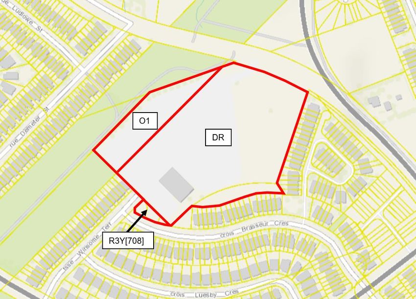
3.4.1 Existing Zoning
The majority of the subject lands are currently zoned “Development Reserve (DR)” in the City of Ottawa
Comprehensive Zoning By-law (2008-250), with the portion of the subject lands located within the hydro
corridor zoned Parks and Open Space Zone (O1) (Figure 15).
April 2020 1830 Trim Road & 1141 and 1153 Brasseur Crescent
Planning Rationale/Design Brief/IERS27
The purpose of the DR zone is to recognize lands intended for future urban development in designations such
as General Urban Area. Permitted uses are limited to:
agricultural use
emergency service
environmental preserve and education area
forestry operation
group home
home-based business
marine facility
one detached dwelling accessory to a permitted use
park
secondary dwelling unit
urban agriculture
Figure 15: Existing Zoning of Subject Lands (GeoOttawa)
April 2020 1830 Trim Road & 1141 and 1153 Brasseur Crescent
Planning Rationale/Design Brief/IERS28
3.4.2 Proposed Zoning
The following zoning is proposed for the subject lands:
A “Residential Third Density Zone with Exceptions (R3YY[XXXX])” zoning for the townhome blocks
proposed along the eastern extension of Winsome Terrace;
“Residential Third Density Zone, Subzone Y, Exception 708 (R3Y[708])” for the 10 townhomes (two
blocks of five units each) planned along Brasseur Crescent, which is consistent with the zoning of the
existing townhomes along Brasseur Crescent; and
“Parks and Open Space Zone (O1)” for the proposed municipal park. The portion of the subject lands
located within the hydro corridor is already zoned O1 and is proposed to remain zoned O1.
The purpose of the R3 zone is as follows:
1. Allow a mix of residential building forms ranging from detached to townhouse dwellings in areas
designated as General Urban Area in the Official Plan;
2. Allow a number of other residential uses to provide additional housing choices within the third density
residential areas;
3. Allow ancillary uses to the principal residential use to allow residents to work at home;
4. Regulate development in a manner that is compatible with existing land use patterns so that the mixed
dwelling, residential character of a neighbourhood is maintained or enhanced; and
5. Permit different development standards, identified in the Z subzone, primarily for areas designated
as Developing Communities, which promote efficient land use and compact form while showcasing
newer design approaches.
The Exception ([XXXX]) proposed for the townhomes along the eastern extension of Winsome Terrace includes
many of the same provisions as were applied in Mattamy’s Summerside South subdivision (file number D02-
02-17-0105), which will result in a similar density and built form. Table 4 below identifies the proposed
R3YY[XXXX] zoning provisions.
Table 4: Proposed R3YY[XXXX] Zoning Provisions
Zoning Mechanism Provision
Min. Lot Width (m) 5.5
Minimum Lot Area (m2) 81
Maximum Building Height (m) 14
Min. Front Yard Setback (m) High No 4.25
Plasticity sidewalk
Soils
Min. Corner Side Yard Setback (m) 2.5
Min. Rear Yard Setback (m) 6
Min. Interior Side Yard Setback (m) 1.5
Projections Despite Table 65, the following is permitted:
April 2020 1830 Trim Road & 1141 and 1153 Brasseur Crescent
Planning Rationale/Design Brief/IERS29
Zoning Mechanism Provision
A chimney, chimney box, fireplace box, eaves,
eave-troughs, gutters and ornamental elements
such as sills, belts, cornices, parapets and
pilasters may project 1 metre into a required front,
corner side or interior side yard but no closer than
0.2 metres to the lot line.
Balconies and porches may project to within 0
metres of a corner lot line.
Despite Table 65, Row 6(a), a deck with a
walking surface higher than 0.3 metres but no
higher than 1 metre above adjacent grade may
project to within 0.6 metres of a lot line, and any
portion of a deck with a walking surface less than
0.30 metres may project to within 0.3 metres of a
lot line
Despite Table 65 Row 6(b), the steps of a porch
may project 2.5 metres into a required yard, but
no closer than 0.5 metres to a lot line.
An air conditioning condenser unit may project 1
metre into a corner and interior side yard, and 2
metres into a rear yard, but no closer than 0.2 metres
to a lot line, and may not be located in a front yard
except in the case of a back-to-back townhouse
dwelling.
Corner sight triangles Section 57 does not apply
The provisions for the R3Y[708]) zoning that is proposed for the 10 townhomes planned along Brasseur
Crescent are outlined in Table 5 below.
Table 5: Proposed R3Y[708] Zoning Provisions
Zoning Mechanism Provision
Min. Lot Width (m) 5
Minimum Lot Area (m2) 150
Maximum Building Height (m) 11
Min. Front Yard Setback (m) High No 5
Plasticity sidewalk
Soils
Min. Corner Side Yard Setback (m) 3
Min. Rear Yard Setback (m) 6.5
Min. Interior Side Yard Setback (m) 1.2
April 2020 1830 Trim Road & 1141 and 1153 Brasseur Crescent
Planning Rationale/Design Brief/IERSYou can also read


