Resource Consent application to Gore District Council and Environment Southland - Prepared for the Longford Bridge and Pathway
←
→
Page content transcription
If your browser does not render page correctly, please read the page content below
Resource Consent
application to Gore District
 Council and Environment
                            Southland
    Prepared for the Longford Bridge and Pathway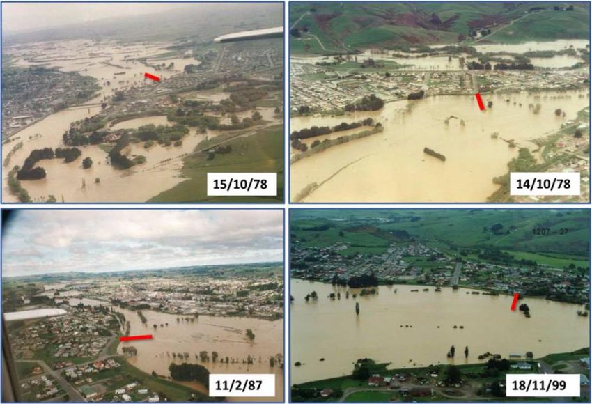
Prepared For
Gore District Council

Prepared By
Landpro Ltd
13 Pinot Noir Drive
PO Box 302
Cromwell
Tel +64 3 445 9905

                                             ii

                        © Landpro Ltd 2020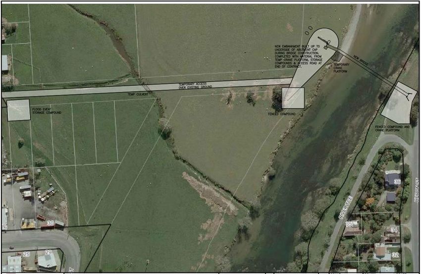
QUALITY INFORMATION
Reference:                  Longford Bridge - AEE - Final for lodgement v3.docx
Date:                       5 August 2020
Prepared by:                Brodie Costello
Reviewed by:                Claire Perkins
Client Review:              Gore District Council
Version Number:             Final – Revision 1

Disclaimer:
We have prepared this report for our client based on their instructions. They may use it, as agreed between us.
Landpro has no duty, and does not make or give any express or implied representation or guarantee, whatsoever to
any person other than our client. If you are not our client then, unless this report has been provided to you as a local
authority or central government agency as part of a public process:
    •    you have no right to use or to rely on this report or any part of it, and
    •    you may not reproduce any of it.
We have done our best to ensure the information is fit for purpose at the date of preparation and meets the specific
needs of our client. Sometimes things change or new information comes to light.                  This can affect our
recommendations and findings.

                                                                                                                      iii

                                                 © Landpro Ltd 2020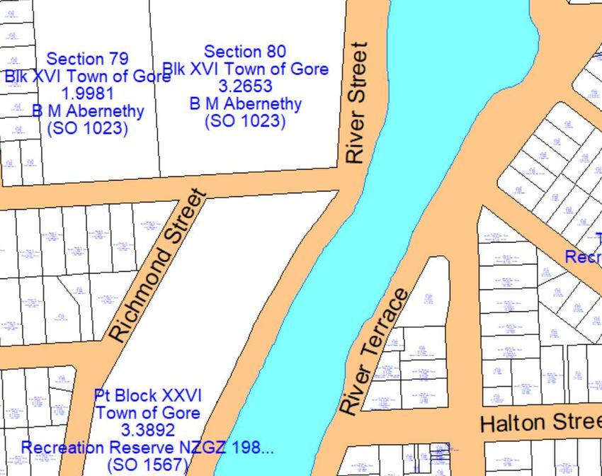
TABLE OF CONTENTS

1.     INTRODUCTION .................................................................................................................................................................. 1
     1.1        Overview of Proposal ............................................................................................................................................. 1

     1.2        The Applicant ............................................................................................................................................................. 2

     1.3        Purpose of Documentation .................................................................................................................................. 2

2.     DESCRIPTION OF PROPOSAL ........................................................................................................................................ 2
     2.1        Location ....................................................................................................................................................................... 2

     2.2        Details ........................................................................................................................................................................... 4

     2.3        Construction Methodology .................................................................................................................................. 5

3.     DESCRIPTION OF EXISTING ENVIRONMENT .......................................................................................................... 9
     3.1        Location and topography ..................................................................................................................................... 9

     3.2        Cultural and historical context ..........................................................................................................................10

     3.3        Climate .......................................................................................................................................................................11

     3.4        Matāura River ..........................................................................................................................................................11

     3.5        Terrestrial ecology .................................................................................................................................................12

4.     SUMMARY OF CONSENT REQUIREMENTS ............................................................................................................12
       4.1.1        District Plan .........................................................................................................................................................14

           4.1.1.1            Permitted activities compliance.......................................................................................................... 17

           4.1.1.2            Permitted baseline of non-permitted activities ............................................................................. 20

       4.1.2        Regional Plans ....................................................................................................................................................27

           4.1.2.1            Permitted activities compliance.......................................................................................................... 28

           4.1.2.2            Permitted baseline of non-permitted activities ............................................................................. 32

           4.1.2.3            Consents required ................................................................................................................................... 34

5.     ASSESSMENT OF ENVIRONMENTAL EFFECTS ......................................................................................................36
     5.1        Assessment of Alternatives ................................................................................................................................36

                                                                                                                                                                                                  iv

                                                                              © Landpro Ltd 2020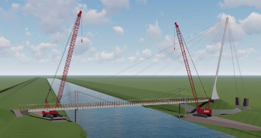
5.2       Positive effects ........................................................................................................................................................38

     5.3       Hydrological effects ..............................................................................................................................................38

       5.3.1       Long-term impacts on flood risk ..................................................................................................................40

       5.3.2       Short-term impacts on flood risk .................................................................................................................41

       5.3.3       Scour and erosion ..............................................................................................................................................42

     5.4       Sediment generation ............................................................................................................................................42

     5.5       Effects on aquatic life ...........................................................................................................................................43

     5.6       Effects on terrestrial ecology .............................................................................................................................44

     5.7       Noise ...........................................................................................................................................................................44

     5.8       Dust .............................................................................................................................................................................45

     5.9       Public access and amenity value ......................................................................................................................45

     5.10      Navigational safety ................................................................................................................................................46

     5.11      Spiritual and cultural values ...............................................................................................................................46

     5.12      Outstanding natural features ............................................................................................................................47

     5.13      Mitigation proposed .............................................................................................................................................47

6.     NOTIFICATION & CONSULTATION...........................................................................................................................49
7.     STATUTORY CONSIDERATIONS .................................................................................................................................50
     7.1       Part 2 of the RMA ..................................................................................................................................................51

     7.2       Section 104(1)(b) of the RMA ............................................................................................................................52

       7.2.1       Southland Regional Policy Statement ........................................................................................................53

       7.2.2       Gore District Plan Objectives and Policies ................................................................................................65

       7.2.3       Southland Water and Land Plan and Regional Water Plan ..............................................................73

       7.2.4       Mataura Water Conservation Order ...........................................................................................................79

                                                                                                                                                                                                 v

                                                                            © Landpro Ltd 2020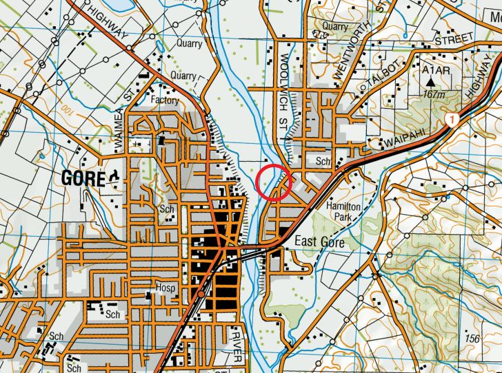
7.2.5        Iwi Management Plan ......................................................................................................................................79

     7.3        Sections 105 and 107 of the RMA ...................................................................................................................83

8.     CONSENT DURATION, REVIEW AND LAPSE..........................................................................................................85
9.     CONCLUSION ....................................................................................................................................................................85

LIST OF APPENDICES

Appendix A: Detailed Bridge Design Plans

Appendix B: Preliminary Shared Pathway Design Plans

Appendix C: Construction Methodology and Plans

Appendix D: Geotechnical and Hydraulic Inputs Report – Longford Shared Path, Gore

Appendix E: Consultation Brochure

Appendix F: Longford Shared Path Business Case

Appendix G: Landscape and Visual Assessment

                                                                                                                                                                                     vi

                                                                         © Landpro Ltd 2020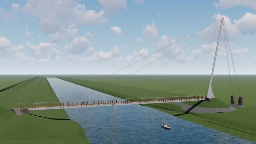
1. INTRODUCTION

1.1 Overview of Proposal
Gore District Council, the applicant, is undertaking a wider project relating to an upgrade of its East Gore water
treatment plant and centralising the treatment of water for Gore.

The project will see:

    •      A membrane filtration treatment plant built at the site of the East Gore treatment plant, in
           Wentworth Street
    •      Water treatment for all of Gore centralised at East Gore, instead of split between East Gore and
           Hilbre Avenue
    •      Construction of a bridge across the Mataura River to attach the new water pipelines linking East
           Gore with the Jacobstown Wells and Hilbre Ave reservoir

One key feature of this project is the new bridge across the Mataura River to carry water pipelines from the
East Gore plant to the Jacobstown wells and Hilbre Ave reservoir. The bridge will be located about 650 metres
upstream from the existing traffic bridge and will also provide a safer shared link for cyclists and pedestrians,
connecting the residential area of East Gore to the CBD and schools located in West Gore.

On the other hand, the Council adopted the Southland Cycle Strategy (2016-26) in 2018. The strategy intends
to promote alternative modes of travel, to unlock and strengthen social connections through the uptake of
cycling.

The main barriers to increasing the uptake of cycling in Gore are severance and safety. The State Highway
(SH) transport routes dissect the town and any walking or cycling trips entail people to interact with highway
traffic. The safety risk of crossing or moving along these major roading corridors, particularly at the SH1
Mataura river bridge, reduces the uptake of active travel. NZTA agree a safe cycling facility needs to be
developed to address these safety and access problems.

This project is developed to address safety and access problems, which includes a shared cycling and
pedestrian track connecting East Gore through the Mataura river to the other side of the town including the
CBD and schools. This link is the most important part of the network as it will provide a connection between
East Gore and businesses, schools, shopping and sporting facilities in Gore. This central link, along with a new
river crossing, will lead to a significant step-change in the provision of safe walking and cycling connections
in the town.

The proposed bridge is a cable-stay design and will be the longest and tallest structure of this type in New
Zealand at 39m high and 90m long. Detailed design plans are contained in Appendix A.

                                                                                                                1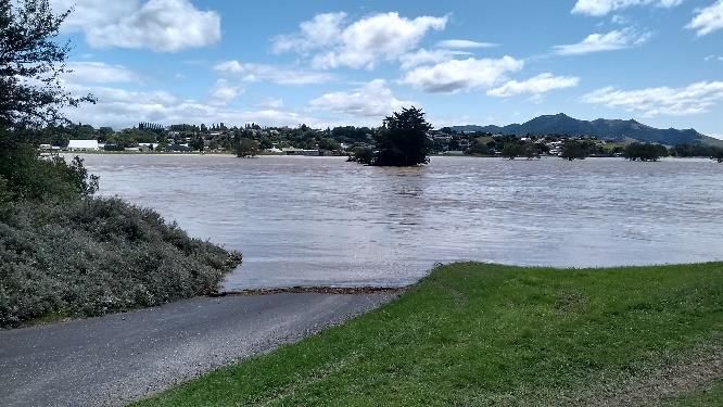
The bridge spans the river near the intersection between Church and Huron streets, on the east bank, and
Surrey Street on the west bank. While this is not the shortest route between the East Gore treatment plant
and Jacobstown, the river is at its narrowest here.

In addition to the bridge construction itself, the proposal involves temporary work to construct two crane
platforms and install temporary piles.

1.2 The Applicant
Applicant Address:        Gore District Council
                          29 Bowler Avenue
                          PO Box 8
                          Gore 9740
                          Attn: Ramesh Sharma, General Manager Infrastructure

Address for Service:      C/- Landpro Limited
                          PO Box 302
                          Cromwell 9342
                          Attn: Claire Perkins

1.3 Purpose of Documentation
Under Section 88 of the Resource Management Act 1991 (the RMA), this report provides an assessment of
the activities effects on the environment as required by Schedule 4 of the RMA.

2. DESCRIPTION OF PROPOSAL

2.1 Location
The proposed bridge is located over the Matāura River on the northern part of the Gore township, as shown
in Figure 1. The associated shared pathway will run south down the true right side of the Mataura River, to
connect with downtown West Gore. This is illustrated in Appendix B.

The specific land parcels on which works will occur are identified on Drawing S100 Rev D in Appendix A. Most
of the works will occur on the legal riverbed and margins, alongside legally identified road reserve and
recreation reserve already owned by the Council. The identified Lot 1 and Lot 2 of Sec 80 Blk XVI indicate the
future subdivision of the property currently owned by Ben Abernethy (Sec 80 Blk XVI). Lot 2, where the
anchors will be located, would then be purchased by the Council.

Figure 2 below, taken from Quickmap, shows the legal description, land owners, legal roads and legal river (in
blue). The western end of the bridge will be at or about map reference NZTM 1287103 E 4887653 N.

                                                                                                            2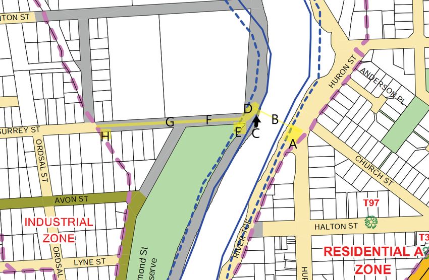
Figure 1: General location of the Longford Bridge identified by the red circle (Source: Topomap, 2020).

Figure 2: Legal description of works location - shown in green (Source: Quickmap, 2020)
                                                                                                          3
2.2 Details
The bridge component of the wider water upgrades project is subject to this consent application for a shared
pedestrian and cycle bridge, spanning the Matāura River within Gore. The bridge will cross from the flood
bank on the eastern side of the Matāura River, to a new causeway embankment on the western side. From
here, the shared pedestrian and cycle path will cross the floodplain to connect with Gore’s CBD, with the final
location of the path still to be confirmed but generally as shown in the preliminary design plans in Appendix
B. Any required fencing of the pathway from stock along the flood plains will consist of 3 wires nailed to posts
on the downstream side. This will ensure that the wires will pull out should any flood debris come down the
river in high flow events.

The bridge will be 39 metres high, 90 metres long and 3 metres wide.

The proposed bridge structure is to consist of a steelwork skeleton encased in timber, with a 916mm
diameter steel mast supporting 26.4mm diameter cables situated along the span of the bridge. The bridge
will have permanent piles outside of the riverbed as well as back-stay anchorages cabled to the mast. The
western end of the bridge will have a built embankment to allow access to the bridge. An illustration, looking
south down the Matāura River, is shown in Figure 2, with the detailed design and illustrative scheme plans
included in Appendix A.

Figure 3: Longford Bridge, looking south (Source: Concrete Structures Ltd, 2019, extract from Appendix C)

                                                                                                              4
2.3 Construction Methodology
The construction programme and tasks are summarised in Table 1, and illustrated in Figures 3, 4 and 5 and
the attached details and plans in Appendix C, provided by the Council and extracted from the construction
plans prepared by the contractor, Concrete Structures Ltd.
A 10-month construction timeframe is proposed. Should consent be granted in time, the current construction
timeline (Appendix C) has onsite construction scheduled to commence at the end of September 2020.
A detailed Construction Management Plan will be prepared by the contractor once their appointment has
been confirmed. This will set out the construction methodology along with final detailed plans showing for
example fenced compounds, stockpiling locations and sediment/dust/noise management etc. A condition to
this effect has been proposed. A preliminary plan showing site access, storage areas and fenced compounds
is shown in Figure 4 below. No road closures are anticipated and public access along the eastern side of the
river will remain.
Figure 4: Fencing, access and storage locations during construction (Source: Concrete Structures Ltd,
2019, extract from Appendix C)
5Table 1: Construction programme (graphic illustration of these steps shown in Drawings 4 and 5 of
Appendix C)
Construction Construction Tasks Comments and Environmental
Sequence Risks
Establish to site • Establish site fencing and Machinery/equipment and hazardous
environmental controls substances used for the activity will
• Set up compound and lay down be located in the fenced compounds
area (refer to Figure 4 for locations).
Bulk Earthworks, • Site clearance The crane platforms will be
Piling & • Topsoil stripping and stockpile constructed in the shallows of the
Abutments • Construct crane access tracks and Mataura River from imported rock
hard standing material (not excavated from river
• Bulk fill to western abutment onsite) and on the western side will
• Install geofabric and riprap to extend approximately 8m into the
abutment locations 62m wide wetted channel (refer
• Install permanent piles for bridge Figures 4 and 5). Some sediment may
abutments – casings filled with be released during the construction.
concrete (outside of riverbed)
• Construct abutments
Erect Bridge Mast • Drive temporary piles to support The temporary UC steel tube piles (no
and Deck construction loads (within riverbed) concrete centre), will be vibrated and
Structure • Erect mast driven into place (within the wetted
• Pour shear keys and install bridge riverbed – refer Figure 5 below for
bearings locations of temporary piles),
• Unload structural steelwork to lay constructed to support temporary
down area construction loads and bracing, and
• Fully construct bridge some sediment may be released
• Install each 45m section in one lift during installation.
onto temporary piles
• Cantilever supported using
temporary RB bracing system
Cable install and • Pin guy ropes to mast
Stressing • Pin all guy ropes to stressing points
on deck
• Stress guy ropes to required
tension
6Construction Construction Tasks Comments and Environmental
Sequence Risks
Remove • Use vibro hammer and crane to Some sediment may be released
temporary piles extract piles during extraction.
Construct round • Install ground anchors Some sediment may be released
Anchor Deadmen • Tie reinforcing steel cages during construction. There is a risk of
• Form and pour anchor deadmen cement or other contaminants being
• Install rip rap to deadmen spilt during construction.
Complete • Finishing earthworks Some sediment may be released
Earthworks • Grass seeding during earthworks.
Disestablish from
site
Figure 5: Longford Bridge construction, showing the temporary piles and crane platforms (Source:
Concrete Structures Ltd, 2019, extract from Appendix C)
7In terms of the environmental management of the construction project, the following major risk identification
and management has been undertaken and is included in Appendix C:
• Sediment release. This may occur during construction of the bridge and the causeway. Sediment
release during piling and other construction activities will be minimised as follows:
o For works involving soil disturbance above the waterline but within the banks, silt fences will be
installed on the down-gradient side of these works within 1m of the edge of the river and extend
20m either side of the work area, and stabilisation as soon as practicable after the relevant task
is completed. Secondary protection will be installed in areas of high earthworks and
groundwater controls and settlement ponds utilised where possible. Stockpiles will be no closer
than 5m to the edge of the river. Note that there will be some works around the waterline to
install erosion control (rip rap).
o Visual monitoring of sediment during the construction and removal of the temporary piles and
crane platform to ensure that there is no visible sediment plume beyond the reasonable mixing
zone (in this case, 200 m, as defined in the Glossary of the Southland Land and Water Plan). If a
visible plume is noted to extend for this distance, the in-stream works will be temporarily
stopped until this dissipates and will then proceed at a slower rate or with additional controls in
place.
o Minimising bed disturbance as far as is practicable during removal of the temporary piles and
the crane platform (shown in Figure 4).
• Release of other contaminants to water, with cement and fuel being the primary concerns. These
will be carefully managed by:
o Carrying out the permanent piling (outside of the river) as noted above, and with the in-situ
concrete to be poured within a pre-driven casing, because this is outside the riverbed, will
effectively eliminate cement discharges to the river.
o Management of refuelling, and regular machinery checks and maintenance to reduce the risk of
any fuel/oil release to the practicable minimum.
o Use of a spill kit if required.
• Flood risk. The presence of the causeway/crane platform in the riverbed will affect the flow path
and stage of the river during flood events. This is an unavoidable effect of the works, but will be
minimised by:
o Completing the in-stream works as quickly as is practicable and safe, therefore minimising the
likelihood that a flood event will occur during the works.
8o Completing a flood assessment to predict the impact of the proposal on the Matāura River
during future flood events, as provided in Appendix D.
o All plant will be required daily to park in a nominated compound elevated from the flood plain.
All small plant will be removed daily.
o Should significant flood events be forecast, plan to remove any temporary crane platform as
necessary, but within 20 hours of a predicted high water event. Staff will always be available
during the working week with the construction team living locally, and one man will be available
on standby and within 2 hours of the site during weekends where the construction team are not
on site.
3. DESCRIPTION OF EXISTING ENVIRONMENT
3.1 Location and topography
The Longford Bridge site is located on the Matāura River, within the Gore township. The site is approximately
650m north of the existing State Highway 1 bridge.
The permanent river channel at the site is approximately 55m wide in typical conditions. The western side of
the river is largely undeveloped land, primarily used for stock grazing, and is generally flat to gentle sloping
(see Figure 6). On the eastern side, the land slopes steeply up towards the 4 m high earthfill stop bank, beyond
which is suburban area. Stopbanks have also been built on both sides of the river, being approximately 250-
300m on the western side and 20m on the eastern side respectively from the permanent river channel.
Engineers soil logs from the investigative drilling are included within the Geotechnical and Hydraulic Report in
Appendix D.
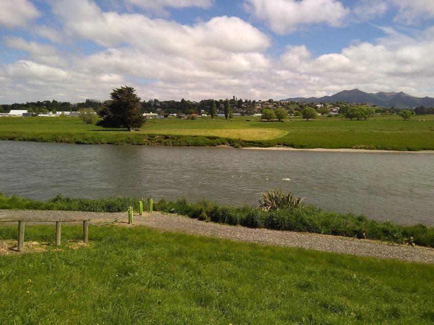
9Figure 6: View looking west from the top of the stop bank on the eastern side of the Matāura River
3.2 Cultural and historical context
The site is within the rohē of Ngāi Tahu. The Matāura River is of special significance to local Māori, both
culturally and as a native fishery and is the subject of a Statutory Acknowledgement. Through previous
consultation we have engaged in with Hokonui Rūnanga, we are aware of the following sites within the
catchment which have particular cultural significance:
• Māori ovens have been located approximately 20-30m downstream of the bridge site on the eastern
banks. While the proposed works will be in close proximity to these, conditions are proposed to
ensure these sites are protected during the works. An Archaeological Authority from Heritage NZ
will also be sought prior to the commencement of any works.
• A Mātaitai Reserve (customary fishing area) on the main stem of the Matāura River near the town
of Mataura. The proposed activity is approximately 10 km upstream of this reserve.
• There are also a number of traditional eel fishing sites along the length of the Matāura. It is unclear
at this stage whether any of these are near the site.
10• Nohoanga (traditional camp sites) on the Waikaia River near Piano Flat and on the Matāura near
Ardlussa. Both of these sites are upstream of the proposed activity.
• The Iwi Management Plan (discussed in detail in Section 7.2.5) also records numerous archaeological
sites within the rohē, but none of these are within approximately 8 km of the site, with the exception
of the Hokonui Rūnanga tribal property, located southwest of Gore. These sites are distant from the
proposed Longford Bridge, and the proposed work will have no effect on them. The Archsite online
GIS viewer shows four sites within 2 km from the site, all located within the western Gore township.
Since European settlement, the dominant land uses are a mix of residential, industrial, and agricultural
activities in the area near the bridge site.
The eastern side (true left) of the subject site includes an existing pathway used for recreational walking,
cycling, and pedestrian access to West Gore. Pedestrians also use a second informal path on the ridge of the
flood bank, running parallel with the river and Huron/Woolwich St.
3.3 Climate
According to NIWA’s Weather and Climate of Southland report, average annual rainfall at Gore is 945 mm.
The Summer months are typically the wettest, with December having the highest average rainfall (100 mm).
The driest months are typically July-September, when approximately 60 mm/month of rainfall occurs on
average.
3.4 Matāura River
The proposed Longford Bridge would be sited over the Matāura River and within the Matāura River
catchment. The catchment extends from the Eyre and Hector Mountain ranges in the north and discharges
into Toetoes Bay, south-east of Invercargill. The Matāura River catchment area upstream of the bridge is
approximately 2693 km2 based on data from NIWA’s NZ River Maps website.
The Matāura River catchment is one of the 10 largest catchments in New Zealand, and is strongly recognised
for recreational fishing, in particular brown trout. Agriculture, including intensive dairy, sheep and beef
farming is the primary land use within this catchment.
Environment Southland monitors flow in the Matāura River at several sites. At Gore, the median flow is
49 m3/s and the Q95 is 16 m3/s as per Environment Southlands Environmental Data website. Flow rates for
the three highest recorded floods is also available, these being 2,111, 1,882, and 1,783 m3/s in 1978, 1987
and 1999 respectively. As detailed in the Geotechnical and Hydraulic Inputs report (Appendix D), future flood
events may generate flows of up to 2,612 m3/s for a 1/50 year event and up to 4,802 m3/s for a 1/500 year
event (including an additional 15% allowance for climate change effects). In such flood events, approximately
one third of the flow is expected to spill out on to the floodplain, with the remainder flowing within the
channel.
11The modelling outlined in the Geotechnical and Hydraulic Inputs report was validated by the recent flood events
in February 2020, where the Mataura River was recorded to peak at 2,450 m 3/s at the Gore monitoring
station. The previous record flood was in October 1978, where the peak was recorded as 2,110 m3/s.
The Land, Air, Water Aotearoa (LAWA) website shows that the area is located within the Mid-Matāura surface
water zone, which extends from the hill country of the Matāura Ranges to Gore. The following information is
available on the LAWA website on the Matāura River at Gore:
• Ecology data shows a macroinverterbrate community index (MCI) of 99, classified as “fair”, a
taxonomic richness of 13, and a percent EPT richness of 41 % (all 5-year medians)
• E. coli concentrations in the last 5 years is 395 n/100ml (median). Based on three years of data, this
site is graded as “unsuitable for swimming”.
• Various water quality parameters show that the site is listed as in the worst 25 % of like sites for
black disc clarity with a 5-year median of 1.04 m, and in the best 50 % of like sites for turbidity (5-
year median: 2.2 NTU).
Overall, these results suggest that water near the site will be of low clarity in typical conditions, with the
worst low-clarity events probably coinciding with high flows.
The Matāura River is host to a renowned brown trout fishery, and a number of native species. The species
present are likely to include long fin eel, lamprey, torrent fish, upland bully, koaro and Galaxiid-gollum. The
conservation statuses of these species range from Not Threatened to Nationally Vulnerable, with the lamprey
being the most threatened species.
3.5 Terrestrial ecology
The surrounding area is dominated by the built urban area, with pastoral areas on the true right side of the
river. The surrounding area contains exotic pasture grasses and the introduced Prunus and Willow trees.
Additionally, the Matāura catchment is known to be a significant habitat for a number of species of ground
nesting bird, however none have been specifically observed on numerous site visits within the footprint of
the proposed bridge and associated works.
4. SUMMARY OF CONSENT REQUIREMENTS
A summary of the activities that require consents, as per the regulatory frameworks of the Gore District
Council and Environment Southland plans, are identified respectively in Table 2 and Table 3 below.
Consideration of permitted activities is also included below.
Overall, the proposed bridge and associated works are considered discretionary activities under the District
12and Regional planning frameworks.
Table 2: Summary of activity status under the District Plan
Activity Status under District Plan Comments
ACTIVITIES TO OCCUR DURING CONSTRUCTION PERIOD ONLY
Landuse consent for Restricted discretionary activity For the construction of the bridge,
bridge construction under Rule 4.11 and Rule 4.A.9 storage of fuel and associated building
materials, and earthworks.
ONGOING/PERMANENT ACTIVITIES
Landuse consent for Discretionary activity under Rule For land use activities not permitted in
bridge construction 4.2.4 the Rural Zone.
Discretionary activity under Rule For activities within the margins of the
2.4.9 Matāura River.
Restricted discretionary activity For daylight admission of the mast of the
under Rule 4.7 bridge.
Restricted discretionary activity For the location of the western end of the
under Rule 4.7A bridge.
Restricted discretionary activity For the mast height of the bridge.
under Rule 4.8
Restricted discretionary activity For the height and ground coverage of
under Rule 7.9.8 the bridge as a utility support structure.
Table 3: Summary of activity status under Environment Southland Plans
Activity Status under RWP Status under PSWLP Comments
ACTIVITIES TO OCCUR DURING CONSTRUCTION PERIOD ONLY
Vehicle and machinery Restricted Restricted For operation of machinery
operations in a stream discretionary activity discretionary activity within the bed of the river.
bed under Rule 45(b) under Rule 77(b)
ONGOING/PERMANENT ACTIVITIES
Construction of a bridge Restricted Restricted For the construction of the
discretionary activity discretionary activity new bridge.
under Rule 26(b) under Rule 57(b)
Erosion control Discretionary activity Discretionary For rocks to be placed for
structures under Rule 30(c) activity under Rule the crane platforms and
61(c) reused for the
13embankment at the
western end of the bridge.
Following discussion with Colin Young at ES, because resource consent is already required for the proposed
works, a separate authority under the Southland Flood Control and Drainage Management Bylaw 2020 for
works within the floodway and over the stopbanks is not required for the bridge. Further authority under this
bylaw may be required for construction of the associated shared path on the western banks may be required,
however, works associated with the shared path are not covered by this application.
Full details of the consents required under both the ES and GDC planning framework have been included here
in the same application document in order to ensure a full understanding of the nature of the proposal (as
required under s91 of the RMA). However, Council requests that the consents under each consent authority’s
jurisdiction are processed separately. The reasons for this are the nature of the effects associated with the
required consents are relatively distinct, but more particularly, other than iwi, affected parties do not overlap
and the ES consents are more likely to be able to be processed non-notified (see discussion in Section 6
below). Section 102(4A) of the RMA provides for this situation and states that in the situation where consent
authorities separately decide applications, they ensure that any conditions to be imposed are not inconsistent
with each other.
4.1.1 District Plan
The Gore District Council has statutory jurisdiction for the effects of certain activities within the area covered
by this application. These effects are managed through the District Plan, which sets out rules for managing
the effects of the proposed activities.
As shown on the GOR 07 Planning Map, the subject site is located on land that is unzoned (being road reserve,
river margins and riverbed) and in the Rural Zone. The subject site is also located within the Matāura River
Floodway, as shown on the GOR 07 Hazards and Utilities map. A small part of the subject site includes reserve
land (see Figure 2).
14Figure 6: Gore District Map, with proposed activity areas shown in yellow (Source: GOR 07 Planning Map,
2020).
The following proposal components and their approximate locations within the Gore District Plans are
described in Table 4. A full scheme plan illustrating the project components is attached in Appendix A.
Table 4: Proposal components and their locations within the Gore District Plans
Map Component Zone Temporary/Permanent
key
A Fenced Road reserve and river margins. Temporary – Will be used during
compound Partially within the Mataura River construction.
and crane 20M Buffer Zone.
platform
B Bridge Within the legal riverbed and river Permanent.
margins. Crosses the Matura River
and is within the Mataura River 20M
Buffer Zone.
C Crane Within the legal riverbed and river Temporary – Will be removed once
platform margins. Within the Mataura River construction is completed.
1520M Buffer Zone, and a small part
within the Mataura River.
D Embankment Rural Zone and river margins. Within Permanent.
the Mataura River 20M Buffer Zone.
E Fenced Rural Zone and river margins. Within Temporary – will be used to hold
compound reserve land and within the Mataura machinery during construction.
River 20M Buffer Zone.
F Temporary Rural Zone. Temporary – Will only be used for
access road machinery access to the site during
construction.
G Temporary Rural zone. Temporary – To be removed once access
culvert to the construction site is no longer
required.
Note: The proposed access to the site
may not require a culvert. Temporary
access may instead be gained utilising an
existing track on the adjacent property,
north of the proposed bridge location.
H Flood event Located in the Rural Zone. Temporary – Will be used to hold
storage equipment in the event of a flood.
compound
The proposed development involves a range of activities which are regulated in the District Plan, as
summarised in Table 5.
Table 5: Summary of activity status under the District Plan
Activity Status under District Plan
ACTIVITIES TO OCCUR DURING CONSTRUCTION PERIOD ONLY
Construction of the bridge Permitted activity under Rule 4.3
Permitted activity under Rule 4.5
Permitted activity under Rule 4.10
Permitted activity under Rule 6.9
ONGOING/PERMANENT ACTIVITIES
Bridge construction Discretionary activity under Rule 4.2.4
completed Discretionary activity under Rule 2.4.9
Restricted discretionary activity under Rule 4.7
Restricted discretionary activity under Rule 4.7A
Restricted discretionary activity under Rule 4.8
16Restricted discretionary activity under Rule 4.11 and 4.A.9
Restricted discretionary activity under Rule 7.9.8
4.1.1.1 Permitted activities compliance
Table 6 sets out the relevant District Plan rules relating to the permitted activities involved in the works.
17Table 6: Permitted activities under the District Plan
Rules under Provision Assessment
the District
Plan
4.3. (1) The following is a permitted activity: Contractors have confirmed that they will conform with the specified noise limits
Temporary (c) Construction, maintenance and demolition work provided that it as per Rule 4.5 of the Gore District Plan, which has a more restrictive noise limit
activities complies with the recommended noise limits set out in NZS than that set out in NZS 6803:1999.
6803:1999.
4.5. Noise Unless otherwise stated, all activities shall comply with the following There is the potential for increased noise associated with the users of the
standards: proposed bridge structure, none of which will exceed the noise limits specified.
(1) Noise limits in rural and residential zones Noise associated with the bridge construction is inevitable given the machinery
On any day: 7.00 a.m. to 10.00 p.m. 55 dBA Leq required, such as hammers for driving pile sections and earthmoving equipment
10.00 p.m. to 7.00 a.m. 40 dBA Leq such as excavators. Noise will be minimised as far as practical through the use of
10.00 p.m. to 7.00 a.m. 75dBA Lmax silenced earthmoving machinery/equipment and compressors.
Measured: Noise will be monitored at the boundaries of the site and at an equivalent
Rural zones at any point in the notional boundary of any noise distance to the nearest house to ensure no nuisance is being caused, as part of
sensitive activity. the on-site auditing process. Regular contact with landowners will be carried out
Residential zones at any point in any other site. to ensure noise levels are not causing undue stress. Contractors have confirmed
that all construction activities will comply with the specified noise limits set by
this Rule.
4.10 Signs (1) The following signs are a permitted activity throughout the Signs will be required for traffic management and informational purposes during
district. construction. Site fencing and environmental controls will be the first onsite
(a) Electioneering signs work, which will include signage.
(b) Traffic management signs, directional signs and public
information signs erected by the road controlling authority
(c) Signs advertising a property for sale:
18Rules under Provision Assessment
the District
Plan
(i) Located on the property
(ii) Limited in area to 1.2 square metres, for any individual selling
privately, or for any companies acting as agents for that sale.
6.9 Hazardous (1) It is a permitted activity to store or use hazardous substances A small amount of hazardous substances will be stored on site, in quantities that
Substances provided that the quantities in storage or use do not exceed the do not exceed the amounts specified in Table 6.2. These include approximately
amounts specified in Table 6.2. 20L of diesel, 5L of paint, 9kg of LPG, and 30kg of oxygen.
(2) Any storage or use of hazardous substances that exceeds the All hazardous substances can be moved prior to any flood events. Spill kits will be
quantities specified in Table 6.2 is a restricted discretionary activity. maintained on site and a register of all spills kept. Best practice will be used to
The matter over which the Council shall exercise its discretion shall determine fueling location and waste disposal.
be the environmental effects of storing or using hazardous
substances in quantities in excess of those specified in Table 6.2.
(3) Facilities for the disposal of hazardous substances are a
discretionary activity.
194.1.1.2 Permitted baseline of non-permitted activities
Table 7 shows the permitted activities which the proposal is unable to comply with, and therefore in relation to which consent is required. In summary, consent is
required for these works due to the height of the mast of the bridge, and the activities that will take place within the Matāura River Floodway.
Table 7: Summary of the permitted baseline for activities requiring consent
Rules under the Provision Assessment
WLP
4.2.1 General Rule The following land use activities are a permitted activity: The proposed activity is not considered one of the permitted
(1) Rural zone land use activities under the Gore District Plan.
(a) Agriculture;
(b) Animal Boarding Activity;
(c) Farm Quarry;
(d) Essential Services;
(e) Home Occupation;
(f) Home Stay;
(g) Land Development;
(h) Residential Activity on:
(i) a site equal to or exceeding 2 hectares in area; or
(ii) a site of more than 2,000 square metres and less than 2
hectares in area existing, or approved for subdivision, prior to 27
March 2014.
(i) Roadside Sales Activity;
(j) Temporary Military Training;
(k) Veterinary Clinic.
(2) Residential A zone
20(a) Health Care Activity;
(b) Home Occupation;
(c) Home Stay;
(d) Hospital Activity;
(e) Land Development;
(f) Residential Activity:
(i) on site located within 30 metres of the Council’s reticulated
sewerage system:
(a) equal to or exceeding 400 square metres in area; or
(b) of less than 400 square metres in area existing, or approved for
subdivision, prior to 27 March 2014
(ii) on a site located more than 30 metres from the Council’s
reticulated sewerage system that has an area of at least 2,000
square metres.
(g) Residential Care Activity limited to a maximum of 6 persons.
2.4.9 Margins of Within the area 20 metres each side of the bed of the Mataura River where land is The mast of the bridge exceeds the height restriction
rivers and zoned Rural, the following is a discretionary activity: specified in part 2. The western embankment will exceed the
streams (1) Mining or quarrying activities. fill restriction specified in part 3(c). A full assessment is
(2) The erection of any structure greater than 3 metres in height or 6 square metres in provided in above.
area.
(3) Earthworks, other than those associated with the tilling of the soil, fencing or pest
plant management, exceeding:
(a) more than 100 linear metres along the river; or
(b) 1 metre in depth in the case of excavation; or
(c) 3 metres in height in the case of stockpiles or fill; or
(d) 50 cubic metres in volume.
214.7 Daylight (1) Any structure, or production forestry where the contiguous land is not held in the The western end of the bridge is proposed to be constructed
Admission same Certificate of Title, or heaps of material, shall comply with the following partially on private land (in the rural zone), which is affected
standards: as per this rule. The affected landholder is aware of the
(a) Rural zones proposed bridge location, and direct consultation has begun
(i) Except as provided for by (ii) below, no building or other structure shall extend with the affected party, and to discuss subdivision and land
beyond the recession plane calculated from Diagram 4.2, measured from the purchase of a small area. The relevant parcel of land is
boundary of the site. currently used for grazing stock.
(ii) No recession plane is required along the boundary of any site that is contiguous
with the boundary of any Commercial, Industrial or Mixed Use Zone.
(b) Residential zones
No building or other structure shall extend beyond the recession plane calculated from
Diagram 4.2, measured from the boundary of the site.
(c) Commercial, Industrial and Mixed Use zones
No building or other structure shall extend beyond the recession plane calculated from
Diagram 4.2, measured from a point three metres on the Commercial, Industrial or
Mixed Use Zone side of any Residential or Rural Zone boundary.
(2) Any land use activity that does not comply with (1) above is a restricted
discretionary activity.
The matters over which Council shall exercise its discretion are the adverse
environmental effects of the matters with which there is non-compliance.
4.7A Yards (1) For the avoidance of doubt, except where provided in Rule 4.7A.1(3)(a)(ii), all While the Gore District Plan does not provide a definition for
structures and parts of structures, including eaves, gutters and associated downpipes, a ‘Building’, this rule has been applied to the proposed bridge
on any building shall comply with Rule 4.7 Daylight Admission. for completeness.
(2) Rural Zones Please see the response to Rule 4.7 for further information.
(a) Except as provided for in (b) below and subject to (c) – (e) below, all buildings shall
be set back at least 6 metres from the property boundary.
(b) Buildings of less than 10 square metres in area may be located no less than 2
metres from any property boundary, provided that no animals are housed within them.
22(c) Any building housing animals, or any building associated with agricultural use
within which animals are present (including dairy sheds and shearing sheds), shall be
located no closer than:
(i) 30 metres from a legal road boundary; and
(ii) 50 metres to any other property boundary.
(d) Dwellings shall be located such that they are no closer than 20 metres from a
dwelling on an adjoining property.
(e) Buildings shall be set back 6 metres from any waterway more than 2 metres in
width.
(3) Residential Zones:
(a) The following yards shall be provided adjacent to property boundaries: Front Yard
4.5 metres Other Yards 1.0 metre Except that:
(i) Eaves, gutters and associated downpipes on any building may project into a yard by
up to 500 mm.
(ii) In relation to yards, other than front yards, where buildings on an adjoining property
have a common wall along the property boundary, no yard is required along that part
of the boundary covered by such a wall.
(iii) A carport or garage, either stand alone or attached to the dwelling, (including any
eaves, gutters or downpipes) may be located up to 500 mm from the property
boundary provided that the maximum length of the building adjacent to the property
boundary does not exceed 6 metres.
(b) In relation to a structure or part of a structure used for the parking of vehicles, an
area of at least 4.5 metres long and 2.5 metres wide shall be provided on the site and
immediately in front of the vehicle entrance to that structure for the manoeuvring or
standing of vehicles.
(c) Where the aggregate length along the external wall of a building exceeds 16 metres
measured parallel to an internal boundary of a property:
(i) except where provided for by 3(a)(ii) above, no more than 6 metres of that length
23may be located within 1 metre of the distance from the boundary required by Rule 4.7
Daylight Admission or 3(a) above, whichever is the greater.
(ii) within each one metre setback thereafter the maximum length of building that may
be erected is six metres.
(4) Any land use activity that does not comply with (2) or (3) above is a restricted
discretionary activity.
The matters over which Council shall exercise its discretion are the adverse
environmental effects of the matters with which there is non-compliance.
4.8 Height (1) No structure shall exceed the following heights: The mast of the bridge (and the attached guy wires), located
(a) In Residential Zones 8 metres on the western end of the bridge in the Rural Zone, will be
(b) In Rural and Commercial Zones 12 metres approximately 40m high and is not compliant with the height
(c) In Industrial Zones 15 metres restrictions for structures in the rural zone. The eastern end
(d) In Mixed Use Zone bounded by Lyne St, Ordsal St, Traford St and Hokonui Drive 12 and total span of the bridge is less than 12m above the
metres natural ground level and does not breach height restrictions.
(e) Other Mixed Use Zones 15 metres For those viewing the bridge, the mast will have a range of
(2) Any land use activity that does not comply with (1) above is a restricted effects dependent on the point of view. The most impacted
discretionary activity. will be those who are located south/southeast of the bridge,
The matters over which Council shall exercise its discretion are the adverse where the mast of the bridge will contrast the rural landscape
environmental effects of the matters with which there is non-compliance. looking up the Mataura River towards the Waterfall Range,
having moderate to high visual effects. From other
viewpoints, the mast will have a lesser effect, given the
existing built structures within the landscape.
4.11 and 4A.9 (4.11) Refer to Section 4A.9. The proposed activity will take place within the Mataura River
Natural Hazards (4.A.9.1) Within areas shown as “Mataura River Floodway” on the Planning Maps and Floodway, including the erection of the bridge, storage of
within defined not classed as riverbed: hazardous substances, and earthworks.
floodways (1) the erection or alteration of any structure; All machinery will be required daily to park in a nominated
(2) storage of hazardous substances; compound which is elevated from the flood plain at the end
(3) farm quarries and earthworks; of Surrey Street, on the border of the Industrial and Rural
24(4) subdivision; Zones. All small machinery and equipment will also be
(5) forestry and shelter belts; removed from the flood plain daily and secured in the
(6) storage of floatables; compound.
(7) permanent fences; Staff will always be available during the working week with
is a restricted discretionary activity. The matters over which Council shall exercise its the construction team living locally. One person will be
discretion are the adverse effects of natural hazards on or by the proposed activity. available on standby and within 2 hours of the site during
weekends where the construction team are not onsite. All
machinery/equipment is mobile and can be walked or
transported out of the flood way and onto the stopbanks
within half a day. The temporary piles will be designed to
withstand full flood loadings.
Flood monitoring and evacuation procedures will be in place
to ensure the floodway can be evacuated within 20 hours of
a predicted highwater event. To mitigate the risk, weekly and
daily monitoring of Metservice forecast and rain radar will be
undertaken, along with any severe weather warnings are
scrutinized to see if the programme needs to be adapted.
7.9.8 Utilities (8) Other utilities As the bridge will have an attached water pipe, the bridge
(a) Except as otherwise provided by Rule 7.9 (3)-(7) utilities are a permitted activity could be considered as a support structure. The mast height
subject to the following standards: of the bridge is not compliant with the height restrictions
(i) Any support structure greater than 6 metres in height shall comply with Rule 4.7.1 within the Rural Zone, as described above.
Daylight Admission.
(ii) All structures shall comply with Rule 4.8.1 Height
(iii) Within Residential and Commercial Zones, no ground-mounted structure shall
exceed a height of 2 metres and a ground coverage of 6 square metres.
(iv) Within Rural, Industrial and Mixed Use Zones, no ground-mounted structure shall
exceed a height of 3 metres or a ground coverage of 10 square metres.
(b) Any other utilities that do not comply with any part of paragraph (8)(a) above are a
25restricted discretionary activity. The matters over which Council shall exercise its
discretion are the adverse environmental effects of the matters with which there is
non-compliance.
Therefore, the resource consent required under the Gore District Plan is for a land use consent for the activities as described above as a discretionary activity overall.
264.1.2 Regional Plans
Environment Southland currently has two Regional Plans relating to bridges and other activities in stream
beds:
• The Regional Water Plan (RWP), which became operative in 2010, and
• The Proposed Southland Water and Land Plan (WLP), the decisions version of which was released in
April 2018. The WLP will replace the RWP once all appeals have been resolved.
Under the Resource Management Act, rules in a regional plan relating to water, air and soil have immediate
legal effect once they have been notified, while the operative plan rules also still have effect. Because the
WLP is very close to becoming fully operative, the following discussion of plan rules focusses on the WLP
rules. In practice this is somewhat academic as none of the relevant rules have changed substantially and the
status of each element of the proposal is the same under both plans. The proposed development involves a
range of activities which are regulated in the WLP and RWP, as summarised in Table 8.
Table 8: Summary of activity status under Environment Southland Plans
Activity Status under RWP Status under WLP Comments
ACTIVITIES TO OCCUR DURING CONSTRUCTION PERIOD ONLY
Vehicle and machinery Restricted Restricted For operation of
operations in a stream discretionary activity discretionary activity machinery within the
bed under Rule 45(b) under Rule 77(b) bed of the river.
ONGOING/PERMANENT ACTIVITIES
Construction of a bridge Restricted Restricted For the new bridge.
discretionary activity discretionary activity
under Rule 26(b) under Rule 57(b)
Erosion control Discretionary activity Discretionary activity For rocks to be placed for
structures under Rule 30(c) under Rule 61(c) the crane platforms and
reused for the
embankment at the
western end of the
bridge.
274.1.2.1 Permitted activities compliance
Table 9 sets out the general conditions that apply to many of the relevant rules under the WLP, and also the rules relating to the permitted activities involved in the
works.
Table 9: General conditions and permitted activities under the WLP
Rules under the Provision Assessment
WLP
Rule 55A – (a) Fish passage is not impeded as a result of the activity; and There will be little, if any, impediment to fish passage as a result of the
General (b) There is no disturbance of roosting and nesting areas of the black fronted proposed works. All activities will be managed to avoid disturbance of
conditions for tern, black billed gull, banded dotterel or black fronted dotterel; and any nesting areas of the birds referred to in condition (b). Bed
activities in river (c) Any activity in the water is kept to a minimum to avoid, as much as possible, disturbance and work in the water will be kept to a minimum to
and lake beds discoloration of the water in the water bodies listed in the chapeau of the rule, minimise sediment generation. No contaminants (other than
including from any temporary sediment release; and potentially sediment) will be released by the use of the structure.
(d) Any bed disturbance is kept to the minimum necessary to undertake the Equipment will be cleaned as required before being removed from the
activity and the bed is returned as near as practicable to its original channel site at the completion of the works, and the site will be left tidy.
shape, area, depth, and gradient on completion of the activity (with the Neither the works, nor the resulting bridge are expected to result in
exception of revegetation); and significant erosion or deposition. The structure will be maintained in
(e) No fuel storage or machinery refuelling occurs on any area of the bed; and good repair. The area near the bridge is not whitebait habitat.
(f) No contaminants, other than sediment released from the bed, are The only condition with which the project does not comply is (e), as
discharged to water as a result of use of the structure unless allowed by a machinery will need refuelling within the riverbanks (not within the
relevant permitted activity rule in this Plan or a resource consent; and wetted bed) of the Mataura River. This will be managed as discussed
(g) Before any equipment, machinery, or operating plant is moved to a new in above. This general condition applies to a large number of the
activity site it is effectively cleaned to prevent the spread of “pests” or relevant rules, and therefore several activities which would otherwise
“unwanted organisms” as defined by the Biosecurity Act 1993; and be permitted require consent.
(h) All equipment, machinery, operating plant and debris associated with the
28You can also read