River linking in India: Downstream impacts on water discharge and suspended sediment transport to deltas - Elementa: Science of the Anthropocene
←
→
Page content transcription
If your browser does not render page correctly, please read the page content below
Higgins, SA, et al. 2018 River linking in India: Downstream impacts on water
discharge and suspended sediment transport to deltas. Elem Sci Anth, 6: 20.
DOI: https://doi.org/10.1525/elementa.269
RESEARCH ARTICLE
River linking in India: Downstream impacts on water
discharge and suspended sediment transport to deltas
Stephanie A. Higgins*,†, Irina Overeem*, Kimberly G. Rogers* and Evan A. Kalina‡,§
To expand agricultural production and address water scarcity, India is moving forward with the National
River Linking Project (NRLP), which will connect 44 rivers via 9,600 km of canals. Here, we compile the
first complete database of proposed NRLP dams, reservoirs and canals, including operating schedules for
Himalayan infrastructure. We evaluate potential NRLP-derived changes to mean annual water discharge
for 29 rivers and mean monthly water and sediment discharge for six rivers flowing to five major deltas.
Sediment rating curves are used to quantify the impacts of changing water discharge within the rivers,
and basin-wide trapping efficiency is established for new reservoirs. Given full implementation of the NRLP,
we forecast reductions in annual suspended sediment transport to deltas of 40–85% (Mahanadi), 71–99%
(Godavari) and 60–97% (Krishna) due to profound reservoir trapping and peak streamflow reductions.
The Ganga before its confluence with the Brahmaputra is projected to experience a 39–75% reduction in
annual suspended load. The Brahmaputra before its confluence with the Ganga is projected to experience
a 9–25% reduction in suspended load, despite losing only 6% of its annual water flow. We calculate a
projected corresponding aggradation decrease for the Ganga-Brahmaputra delta from 3.6 to 2.5 mm y–1,
which is a large enough change to drive relative sea-level rise at the delta front. At the remaining four
deltas, the NRLP will exacerbate current sediment starvation. We reconstruct the annual water transfer
volume proposed for the NRLP to be 245 km3 y–1, higher than previous estimates due to the inclusion of
along-canal usage. If completed, the NRLP will transform watershed boundaries, with more than half of
the land in India contributing a portion of its runoff to a new mouth. These impacts may have profound
environmental and public health implications, particularly in the context of future climate change.
Keywords: Inter-basin water transfer; River linking; deltas; subsidence; river network; water scarcity
Introduction tial challenges of food production and clean water access
To expand agricultural production and address water that India will face in the coming century – challenges
scarcity, India is moving forward with a large-scale civil that are being confronted globally as countries face rising
engineering project to connect 44 rivers via a vast net- temperatures, and increasing populations with stressed
work of canals (Joshi, 2013; Bagla, 2014). The National water supplies (Wallace, 2000; Battisti and Naylor, 2009;
River Linking Project, or NRLP, aims to increase irrigated Hanjra and Qureshi, 2010). Interbasin water transfer sys-
area by 350,000 km2 and improve food security and clean tems are a common solution to water scarcity, and the
water access. India receives between 50 and 90% of its NRLP is the largest of many new diversion schemes pro-
annual precipitation during the summer monsoon, dur- posed or underway in China, Brazil, and Central Africa
ing which time water is abundant and floods are com- (Zhang, 2009; Lemoalle et al., 2012). However, large-scale
mon. The NRLP will store and redistribute this water in river diversion projects such as the NRLP can result in far-
an effort to reduce temporal and spatial inconsistencies reaching consequences for downstream river discharge
in supply. The project is intended to address the substan- and delta maintenance. For example, due to damming,
diversions, and increased water usage, the Colorado, Nile,
* Community Surface Dynamics Modeling System, INSTAAR, Indus and Yellow (Huanghe) rivers discharge little to no
University of Colorado Boulder, Boulder, Colorado, US
sediment today, whereas they previously accounted for
†
Department of Geological Sciences, University of Colorado
10% of the global sediment flux to the ocean (Syvitski and
Boulder, Boulder, Colorado, US
Milliman, 2007).
‡
University of Colorado, Boulder, Colorado, US
The NRLP in its current form was designed in the early
§
Cooperative Institute for Research in Environmental Sciences
at the NOAA Earth System Research Laboratory/Global 1980s, when the Indian government established the
Systems Division, Boulder, Colorado, US National Water Development Agency (NWDA) to man-
Corresponding author: Stephanie A. Higgins age implementation of the project. The project stalled
(stephanie.higgins@colorado.edu) between the 1980s and the 2010s, but it was renewed in
Art. 20, page 2 of 24 Higgins et al: River linking in India
2012 following a Supreme Court order to proceed. The Amarasinghe and Sharma, 2008; Joshi, 2013). Sediment
first canal was completed in September 2015; project transport changes that may result from the NRLP have been
completion is expected by mid-century. If fully realized, highlighted as a significant knowledge gap (Bandyopadhyay
the NRLP will consist of 29 canals running a total of 9,600 and Perveen, 2008). Reduced sediment supply has been
km in length. Nine of the canals would each transfer more implicated in the sinking of many major deltas, putting
than 10 km3 y–1 of water. This transfer capacity is greater vital agricultural regions, industrial areas, sea ports, diverse
than that of the current largest canal in the world (the wetlands, and population megacenters at risk (Syvitski et al.,
Central Route of the South–North Water Transfer in China, 2009; Tessler et al., 2015). Deltas downstream of NRLP trans-
which transfers 9.5 km3 y–1; Zhang, 2009). The full system, fers include the Ganga-Brahmaputra, Mahanadi, Godavari,
depicted in Figure 1, would transfer fifty to one-hundred Krishna and Kaveri deltas. These five deltas together host a
times the volume of the largest interbasin water transfer population of more than 160 million people (Higgins, 2015).
system in the United States and will likely constitute the All five deltas currently suffer from reduced aggradation
largest construction project in human history. that, together with land subsidence and global sea-level rise,
Given the far-reaching social, economic, and environ- place the deltas at risk of substantial elevation loss relative to
mental impacts of the NRLP, there have been innumerable sea level (Syvitski et al., 2009; ADB 2011; Tessler et al., 2015).
calls for scientific research into nearly every aspect of the It is therefore essential to establish how NRLP transfers may
proposal (Bandyopadhyay and Perveen, 2003; Mizra, 2008; affect sediment transport to these vulnerable coastal areas.
70° E 75° E 80° E 85° E 90° E 95° E
35° N 35° N
CHINA
PAKISTAN a
30° N 6 rd 30° N
Sa
7
DELHI 5
4 NEPAL
Ya m
anas
un ra
3 ut
Ga
a n BHUTAN
2 ap
Brahm
M
ga
8 an
G
nas G ha
Ba g ha Te
a ra 1
da
tw Ko e
al si
k
a a
Be
st
i
Pa
at
r
g hn
b
n
25° N 25° N
rm
Cham
Ke
10
bati
11
ba
Ho
Me
i n 12
ah So
Sa
og h ly
9 BANGLADESH
Su
M
b arn 14 13
AHMEDABAD ar
a r KOLKATA
Narmad
B
ek
Mahanadi
ahm
Waing a nga
ha
Ta pi 15 lt a MYANMAR
28 G B M De
an
i
Dam an Ganga Te
l
20° N i 20° N
G od ad
29 a v ari an
MUMBAI Bhim
16 M a h ta
Indravati D el
19 18
a
Kr
HYDERABAD
hn
is
a
d
17 an l t a River
s
23
hna i De
s
15° N d
hi 22 20 Kri avar Existing canal
15° N
d
t
Arabian Sea Be Go
24
Pe n n a Bay of Bengal Proposed
Pa Dam
BENGALURU l ar
Netra vati CHENNAI
Barrage
Ka 21
25 Link canal
ver
i
N Completed
K a v e ri
Va
D e lt a
ig 26 Dam
ai
10° N Barrage 10° N
Pamba
Va Link canal
27 ippa
r
70° E 75° E 80° E 85° E 90° E 95° E
Figure 1: Proposed canals, dams and barrages associated with the NRLP. Canals, dams and barrages associated
with the NRLP. Yellow indicates proposed and red indicates completed structures. Canal #17 (red) connecting the
Krishna and Godavari rivers was completed in September 2015. Arrows indicate the direction of water transfer along
the canals. Major river deltas in this study are labeled – the Ganges-Brahmaputra Meghna (GBM) in India/Bangladesh,
and the Mahanadi, Krishna, Godavari and Kaveri deltas in India. The locations and attributes of all canals and dams are
available as shapefiles and in .csv format in Supplementary Material. NWDA names for each canal are given in Table 1.
DOI: https://doi.org/10.1525/elementa.269.f1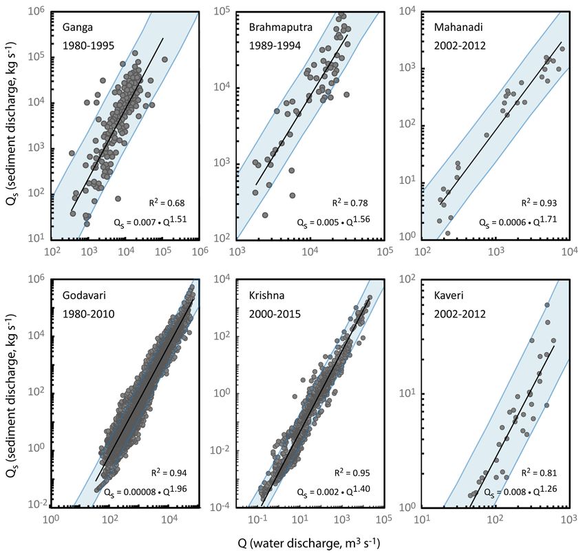
Higgins et al: River linking in India                                                                   Art. 20, page 3 of 24

   Three fundamental processes resulting from the NRLP          negotiations that have moved the location of the primary
have the potential to affect sediment transport. The first      reservoir and revised its operating schedules. A new sum-
is an increase in reservoir trapping, which has already         mary statement has been released, but a new Feasibility
reduced sediment transport globally by 30% (Vörösmarty          Report is not yet available. For link canals 10, 28, and 29,
et al., 2003) and in India by more than 70% (Gupta et           NWDA Detailed Project Reports are available with addi-
al., 2012). New reservoirs associated with the NRLP will        tional information on the canals and associated dams.
further impound sediment, particularly in the relatively        Newer NWDA publications were selected over older pub-
pristine Himalayan rivers. A second impact is expected          lications for inclusion in the dataset.
to result from the storage of high flows during the wet            For the Himalayan (northern) components, NWDA
season and their slow release during the dry season. This       data are much sparser. A pre-feasibility report is avail-
will affect sediment transport due to the non-linear rela-      able for link canal 6 and an NWDA in-house bulletin
tionship between water discharge and sediment transport         gives some information regarding the locations of dams
capacity. Finally, increased water utilization within the       in link canal 1. Otherwise, data on the northern canals
basin will decrease the average water discharge of rivers,      and dams have not been released. It was therefore nec-
reducing their year-round transport capacity, as sediment       essary to supplement NWDA material with data from
load is a function of water discharge for rivers that are not   other sources. To that end, more than 500 documents
supply-limited (Syvitski et al., 2005; Walling, 2008).          from the public domain were reviewed for potential
   Despite the importance of these processes, efforts to        data on NRLP infrastructure. Seventy-five sources were
quantify their impacts within the NRLP have been severely       ultimately included in the database, which together
hampered by a lack of data on the specific transfer volumes     include the most current operating specifications for
and operations of the project as well as the existing condi-    the components (see Supplementary Material). For the
tions in the rivers, particularly for the Himalayan (north-     Himalayan canals, the most comprehensive source of
ern) half of the system. The Indian government restricts        information came in the form of three NWDA charts
access to hydrologic data for the Ganga and Brahmaputra         obtained by Gourdji (2005; 2008) that together depict
basins, and freely available data is sparse and incomplete.     the Himalayan canals’ full transfer, evaporation, utiliza-
Prior to this work, even water discharge changes had not        tion, and outfall volumes.
been tabulated for rivers affected by multiple canals.             Exact latitudes and longitudes were available for
   This paper addresses these challenges and evalu-             approximately half of the dams and none of the link
ates potential NRLP-derived changes to mean monthly             canals. Geo-location of each canal and structure was
water and sediment discharge and delta sedimentation            therefore facilitated by 30 NWDA schematic maps show-
for the Mahanadi, Godavari, Krishna, Kaveri, and Ganga-         ing the approximate locations of dams, barrages, and
Brahmaputra deltas. Additionally, changes to mean annual        water transfer structures in the project. These maps
water discharge are established for 29 rivers. Displaced        were digitized and georeferenced in a GIS framework
population estimates are updated to the current project         (Figure 2). Country and state borders, water bodies, cit-
timeline, and changes to the existing watersheds of the         ies/place names, and existing structures provided geo-
subcontinental river network are mapped. This work is           referencing points. Locations were then refined using
achieved via construction of the first comprehensive data-      text-based descriptions in the database sources. For
base of NRLP elements, which includes data for the full         example, no NWDA data is provided for the Chisapani
Himalayan component of the project. A novel graph data-         and re-regulating dams associated with link canal 5, but
base of the river network is developed to track and calcu-      a World Bank study of potential dam sites describes the
late flow. Finally, impacts of the NRLP are discussed within    recommended site:
the context of human and environmental requirements
and future climate change.                                         The study recommended a 270-meter high embank-
                                                                   ment dam located at the upstream site of the Chisa-
Methods                                                            pani gorge… [and] reregulating facilities located 8
Data                                                               km downstream. [...] Although not fully assessed
Infrastructure data                                                yet, there may also be some loss of river habitat
A total of 43 dams and barrages and 29 link canals are             and encroachment on the Royal Bardiya Wildlife
planned in the NRLP (Figure 1). Where possible, infra-             Reserve, which is an area of special environmental
structure data including locations and operating sched-            significance (World Bank, 1992).
ules for dams and canals have been taken directly from
NWDA documents and reports (see annotated reference             Place names such as these were compared to Open
list, Supplementary Material). Table 1 gives the NWDA           Street Map, India-WRIS (Water Resources Informa-
name for each canal. For the Peninsular component,              tion System of India) dam databases, Google Maps and
NWDA summary statements and Feasibility Reports with            DigitalGlobe/Google Earth satellite imagery, SANDRP
operating schedules are available for canals 9, 10, and         publications, and news articles to refine structure loca-
16–29 and their associated dams, with the exception of          tions and link canal routes. Where existing irrigation
a missing summary statement for link canal 29 and a             canals or smaller rivers were to be utilized along the link
missing Feasibility Report for link canal 25. The Feasibil-     canal routes, these were extracted from Open Street Maps
ity Report for link canal 16 is unavailable due to recent       and joined with the routes.
Art. 20, page 4 of 24 Higgins et al: River linking in India
Table 1: Canal numbers and corresponding NWDA names. DOI: https://doi.org/10.1525/elementa.269.t1
Canala NWDA name Offtake river Outfall river
1.1 Manas-Sankosh-Tista-Ganga Manas Canal
1.2 Manas-Sankosh-Tista-Ganga Sankosh Canal
1.3 Manas-Sankosh-Tista-Ganga Raidak Canal
1.4 Manas-Sankosh-Tista-Ganga Torsa Canal
1.5 Manas-Sankosh-Tista-Ganga Jaldhak Ganga
2 Kosi-Mechi Kosi Mechi
3 Kosi-Ghaghara Kosi Ghaghara
4 Gandak-Ganga Gandak Ganga
5 Ghaghara-Yamuna Ghaghara Yamuna
6.1 Sarda-Yamuna Sarda Canal
6.2 Sarda-Yamuna Upper Ganga Yamuna
7 Yamuna-Rajasthan Yamuna Canal
8 Rajasthan-Sabarmati Canal Sabarmati
9.1 Parbati-Kalisindh-Chambal Parbati Canal
9.2 Parbati-Kalisindh-Chambal Newaj Canal
9.3 Parbati-Kalisindh-Chambal Kalisindh Chambal
10 Ken-Betwa Ken Betwa
11 Chunar-Sone Barrage Ganga Son
12 Sone Dam-Southern Tributaries of the Ganges Son Ganga tributaries
13 Farakka-Sundarbans Ganga Hooghly
14 Ganga-Damodar-Subernarekha Ganga Canal
15 Subernarekha-Mahanadi Canal Mahanadi
16.1 Mahanadi (Manibhadra)-Godavari (Dowlaiswaram) Mahanadi Godavari
16.2 Mahanadi (Manibhadra)-Godavari (Dowlaiswaram) Mahanadi Godavari
17 Godavari (Polavaram)-Krishna (Vijayawada) Godavari Krishna
18 Godavari (Inchampalli)-Krishna (Pulichintala) Godavari Krishna
19 Godavari (Inchampalli)-Krishna (Nagarjunasagar) Godavari Krishna
20 Krishna (Nagarjunsagar)-Pennar (Somasila) Krishna Penna
21 Pennar (Somasila)-Palar-Cauvery (Grand Anicut) Penna Kaveri
22 Krishna (Srisailam)-Pennar Kirshna Penna
23 Krishna (Almatti)-Pennar Krishna Penna
24 Bedti-Varada Bedthi Varada
25 Netravati-Hemavati Netravati Hemavati
26 Cauvery (Kattalai)-Vaigai-Gundar Kaveri Gundar
27.1 Pamba-Achankovil-Vaippar Pamba Canal
27.2 Pamba-Achankovil-Vaippar Achankovil Vaippar
28.1 Par-Tapi-Narmada Par Canal
28.2 Par-Tapi-Narmada Auranga Canal
28.3 Par-Tapi-Narmada Ambika Canal
28.4 Par-Tapi-Narmada Purna Narmada
29.1 Damanganga-Pinjal Daman Ganga Canal
29.2 Damanganga-Pinjal Vaitarna Thane Creek
a
Canal numbers are a convention of this study and do not correspond to those used in some NWDA figures and publications.
For the 29 link canals, the following data were com- supplementary canals database). For the 43 dam struc-
piled: locations (GIS shapefiles of route traces), annual tures, the following data were compiled: location (lati-
water transfer volumes, operating schedules, en route irri- tudes and longitudes), operating specifications (days or
gation, en route domestic and industrial usage, and trans- months of operation), full reservoir level (water elevation
mission losses (seepage and evaporation) (Table 2; and in meters), maximum (gross) storage, minimum (dead)Higgins et al: River linking in India Art. 20, page 5 of 24
Figure 2: Geo-referenced NWDA maps. As part of database construction, 30 maps from published NWDA Feasibility
Reports were geo-referenced in a GIS framework. Country and state borders, water bodies, cities/place names, and
existing structures provided geo-referencing points. The maps were used in conjunction with written location descrip-
tions in NWDA sources, Open Street Map extracts, Google Earth/Google Maps data, and other published sources to
establish dam and link canal locations. DOI: https://doi.org/10.1525/elementa.269.f2
storage, submergence area, forested submergence area, tion density for the year 2020 is divided by the population
and estimated displaced population (Table 3 and supple- density from the year 2000 to obtain the 20–year growth
mentary dams database). rate (Figure 3). The 20–year growth rate is then linearly
scaled to the number of years between the reported cen-
Population displacement data sus estimate and the year 2020 in order to estimate popu-
NWDA estimates of displaced population for most dams lation displacement for a 2020 c onstruction scenario. For
in the peninsular (southern) half of the NRLP are based locations where no population displacement was avail-
on census data collected between 1986 and 1993 and are able, the 2020 population densities for the dams’ loca-
therefore out-of-date for a projected construction date of tions are used in conjunction with the submerged area
2020 or later. For dams in the Himalayas and in much of to estimate displacement. Submerged areas were taken
the Ganga basin, no population displacement estimates directly from NWDA documents and other sources (see
are available. We therefore estimate displaced p opulations supplementary databases for complete reference list).
for each dam location as follows. For locations where pop- Uncertainty in the obtained displaced population esti-
ulation displacement estimates have been made public, mates relates to both the uncertainty of the original cen-
we calculate a population growth rate factor from the sus estimates as well as the uncertainty and consistency
Center for International Earth Science Information Net- of the projected population density for 2020. However,
work (CIESIN)’s (2016) Gridded Population of the World we still regard this analysis as a significant improvement
dataset, version 4. CIESIN population data are collected at over the outdated reported data because of the relatively
the most detailed spatial resolution available, which for large population growth rates, which reflect an average
India is at the district level (10 – 100 km spatial scale). At population increase of 61% since the original census
each dam location, the CIESIN (2016) projected popula- estimates.Art. 20, page 6 of 24 Higgins et al: River linking in India
Table 2: Selected details from canals databasea. DOI: https://doi.org/10.1525/elementa.269.t2
Canal Offtake vol. Trans. loss En route irr. Dom. and Ind. Outfall vol.
(106 m3 y–1) (106 m3 y–1) (106 m3 y–1) (106 m3 y–1) (106 m3 y–1)
1.1
23445 228 1212 0 0
1.2 12439 0 0 0 0
1.3 2302 0 0 0 0
1.4 2422 416 1122 0 0
1.5 2602 624 1693 0 37915b
2 5604 52 4644 23 883
3 7482 143 7291 48 0
4 27837 1068 25867 0 902
5 32646 939 22647 1391 7669
6.1 11680 541 1758 0 9381
6.2 11629 0 0 0 11629
7 11629 720 1950 3117 0
8 5842 538 5022 282 0
9.1 644 0 644 0 0
9.2 302 0 302 0 0
9.3 414 0 414 0 0
10 1074 68 366 49 591
11 5918 198 4790 0 930
12 2512 154 1998 360 0
13 8995 0 2000 0 6995
14 28920 1200 6680 0 21040
15 21040 580 6490 0 13970
16.1 13970 0 0 0 13970
16.2 9182 0 5011 125 4046
17b 5325 260 2638 162 2264
18 4370 293 412 3665 0
19 16426 562 1427 237 14200
20 12146 332 3264 124 8426
21 8565 557 3048 1105 3855
22 2310 0 0 0 2310
23 1980 0 1714 56 210
24 242 0 0 0 242
25 188 0 0 0 188
26 2252 115 1952 185 0
27.1 54 0 0 0 54
27.2 580 0 0 0 580
28.1 502 71 502 0 0
28.2 93 13 93 0 0
28.3 415 60 415 0 0
28.4 320 46 320 0 0
29.1 577 0 0 0 577
29.2 332 0 0 0 909c
Totals 9778 117686 10929
a
Additional details, operating specifications, notes, status updates, information on canceled link plans, and methodological details
regarding the calculation of these parameters are available in the full canals database in supplementary materials. “Offtake vol.”
is the annual volume pulled from the donor canal; “Trans. loss” is estimated transmission loss due to evaporation and seepage;
“En route irr.” is planned irrigation usage along the canal; “Dom. and Ind.” is planned domestic and industrial usage along the
canal; and “Outfall vol.” is the annual volume discharged into the receiving canal. Values are NWDA or other government esti-
mates and are taken from source documents listed in the supplemental database.
b
This segment is now complete, but without the Polavaram Dam. Current discharge values without the dam are not available. These
values assume completion of the dam.
c
Outfall volume is greater than offtake volume because most water is sourced from previous segments.
Mean annual water discharge data ydrological Data Books. Published approximately every
H
Hydrological data is available for southern Indian riv- three years, the data books contain water discharge,
ers via the Central Water Commission (CWC) Integrated sediment discharge, basin properties, and water q
ualityHiggins et al: River linking in India Art. 20, page 7 of 24
Table 3: Selected details from dam databasea. DOI: https://doi.org/10.1525/elementa.269.t3
Structure River Canal # Gross storage Submerged 2020
(106 m3) area (km2) Displaced Pop.b
Sankosh Lift Dam Sankosh 1 144 8.21 131
Sankosh Dam Sankosh 1 3919 46.26 869
Manas Damc Manas 1 10938 80 1143
Sapta Kosi High Dam Project Kosi 2&3 13450 190 17847
Sapta Gandaki Damd Gandak 4 342 18 9840
Chisapani Dam Ghaghara 5 28200 339 60000
Re-regulating Damc Ghaghara 5 125 – –
Rupali Gad Re-Regulating Dam Sarda 6 75 4 1316
Pancheswar High Dam Sarda 6 11355 116 22918
Kadwan Dam Son 9 4169 132 53613
Patanpur Dam Parbati 9 156 29.98 9361
Mohanpura Dam Newaj 9 616 70.51 10240
Kundaliya Dam Kalisindh 9 583 74.76 8630
Daudhan Dam Ken 10 2853 90 10007
Barmul Damc Mahanadi 15 & 16 1216 137.68 11261
Six additional dams – 15 & 16 – 203.33 16631
Polavaram Dam Godavari 17 5511 636.91 203025
Pulichintalae Krishna 18 1296 143.99 43500
Inchampalli Dam Godavari 19 & 20 10374 925.55 172138
Kalvapalli Dam Penna 23 83 13.23 1586
Pattanadahalla Dam Pattanadahalla 24 18 1.85 0
Shalamalahalla Dam Shalamalahalla 24 73 8.2 1576
Kerihole Dam Kerihole 25 – 1.2 0
Yattinhole Dam Yattinhole 25 – 2.95 0
Hongadhalladhole Dam Hongadhallad-hole 25 – 3.5 0
Kattalai Barragef Kaveri 26 – 5.1 –
Achankovil Dam Achankovil 27 31 3.23 448
Punnamedu Dam Pamba Kal Ar 27 208 4.4 0
Achankovil Kal Ar Dam Achankovil Kal Ar 27 497 12.41 0
Chasmandva Dam Tan 28 82 6.15 3040
Chikkar Dam Ambica 28 142 7.42 2205
Jheri Dam Par 28 203 8.36 2435
Paikhed Dam Nar 28 229 9.94 4804
Dabdar Dam Kapri 28 223 12.49 3863
Kelwan Dam Purna 28 284 16.29 8723
Khargihill Dam Wagh 29 461 15.58 2226
Pinjal Dam Pinjal 29 483 19 4881
Bhugad Dam Daman Ganga 29 426 19.03 4447
Totals 98765 3416.51 692704
a
Additional details, operating specifications, notes, status updates, barrages not in this table, and methodological details
regarding the calculation of displaced population for each dam are available in the full dam database in supplementary
materials.
b
Estimated displaced population for the structure if completed in the year 2020.
c
For these structures, either live or gross storage was not given; for these cases, live storage was assumed to be 80% of gross storage,
after IWM (2010).
d
This dam site is easily confused with the “Sapta Kosi,” “Kali Gandaki,” and “Budhi Gandaki” sites, but it is independent of these
projects.
e
Pulichintala Project opened in 2014.
f
Kattalai Barrage was completed in 2014.
etrics for most of the major river basins in India.
m Fewer data are available for rivers in the Himalayan
These data, along with NWDA reports and peer-reviewed component of the project. Data from the Ganga and
research on individual rivers, were used to establish cur- Brahmaputra basins are classified by the Indian gov-
rent mean annual flows for most of the rivers in the Pen- ernment and are not included in the Integrated
insular (southern) component of the NRLP. Hydrological Data Books. Therefore, estimates from theArt. 20, page 8 of 24 Higgins et al: River linking in India
World Bank-supported Strategic Basin Assessment of these rivers in order to assess the impacts of monsoon-
the Ganges Basin are used for the current mean annual season storage and dry-season transfers or releases. Given
discharge values for the tributaries of the Ganga. The the non-linear relationship between water discharge
Strategic Basin Assessment is a multi-year effort by and s ediment transport capacity, reducing peak flows is
the Institute of Water Modelling (IWM) in Bangladesh expected to alter sediment transport capacity even if dry-
to develop a shared knowledge base and analytical season flows are increased proportionally.
framework for the Ganga basin. In the Strategic Basin Daily Ganga water discharge data from Hardinge
Assessment, a precipitation-driven numerical model was Bridge and daily Brahmaputra discharge data from
used to produce estimates of mean annual discharge Bahadurabad Gauging Station were provided courtesy
for the Ganga and all its major tributaries. These esti- of the Regional Integrated Multi-Hazard Early Warning
mates include operating reservoirs and irrigation with- System for Africa and Asia (RIMES Project), originally
drawals throughout the basin (IWM, 2010). For the from the Government of Bangladesh. Both gauging sta-
tributaries of the Brahmaputra, mean annual discharge tions are located just inside the border with Bangladesh
values are compiled from individual published sources. on their respective rivers, before the confluence of the
For the main trunks of both the Brahmaputra and the two rivers. The data provided for the Ganga covered the
Ganga, daily discharge data were obtained from the period 1950–2011 but contains gaps in the dry season
government of Bangladesh and processed to establish for later years. The period 1975–2000 is analyzed to
both monthly and annual mean flows. These data are provide the longest possible record with complete dry-
described in the following section. season data beginning after the construction of Farakka
Barrage, which was completed in 1975 and began divert-
Mean monthly water and suspended sediment discharge ing significant flows from the Ganga to the Hooghly
data for the purpose of flushing sediment near the port of
Mean monthly water discharge and suspended sediment Kolkata. The data provided for the Brahmaputra cover
data were obtained for six rivers leading into the five the period 1956–2011, also with gaps in recent years.
selected deltas. Gauging station locations for these data- The period 1975–2005 is analyzed to provide a 30–year
sets are given in Table 4. Monthly data was required for record extending to the most recent possible year with
A. Population density in 2000 B. Predicted population density in 2020
70° 80° 90° 70° 80° 90°
-2
Population density (km ) Population density (km-2 )
0 500 1000+ 0 500 1000+
Proposed dam or barrage Proposed dam or barrage
30° 30° 30° 30°
20° 20° 20° 20°
N
N
10° 10° 10° 10°
70° 80° 90° 70° 80° 90°
Figure 3: Scaling method for determining population displaced by dams. This figure illustrates the popula-
tion density in 2000 and predicted population density in 2020 used to estimate d
isplaced population with NRLP
implementation (see text for methods). NRLP dams are shown as white triangles. DOI: https://doi.org/10.1525/
elementa.269.f3
Table 4: Gauging station locations for delta simulations. DOI: https://doi.org/10.1525/elementa.269.t4
Gauging Station Latitude Longitude Country River
Bahadurabad 25.180 89.660 Bangladesh Brahmaputra
Hardinge Bridge 24.065 89.029 Bangladesh Ganga
Tikarpara 20.589 84.783 India Mahanadi
Polavaram 17.256 81.657 India Godavari
Vijayawada 16.501 80.625 India Krishna
Upper Anaicut 10.891 78.581 India KaveriHiggins et al: River linking in India Art. 20, page 9 of 24
complete dry-season data. Inter-annual standard devia- standard deviations are computed directly from the
tions for each month are computed directly from the monthly data.
data. Suspended sediment concentration data were obtained
Daily Godavari and Krishna discharge data from for the selected six rivers. A sediment rating curve was fit-
Polavaram and Vijayawada Gauging Stations were pro- ted to the data with the form:
vided courtesy of the Office of the Chief Engineer, Krishna
and Godavari Basin Organization. Both Polavaram and
Q s = aQ b , (1)
Vijayawada are the terminal gauging stations for these
basins and are located just upstream of the deltas. As with
the Ganga and Brahmaputra rivers, a record of at least 30 a widely-applied form for the relation between water dis-
years is desirable for assessing true mean conditions in the charge Q in m3/sec and suspended sediment discharge Qs
presence of high inter-annual variability. For the Krishna in kg/s, with two empirically-derived constants for individ-
river, however, a strong decreasing trend in discharge over ual rivers (Islam, 1999; Syvitski et al., 2005; Walling, 2008).
the last 50 years renders long-term averages meaningless 95% confidence intervals were calculated following Mont-
with respect to current conditions. Between the 1960s gomery and Runger (2011) using a student’s t-distribution
and today, mean annual water discharge of the Krishna (2α) in conjunction with the standard deviation of Qs and
fell from 62 km3 y–1 to just 12 km3 y–1, of which 95% comes the sum of squares of deviations of data points from their
during the monsoon season (Rao et al., 2010). The Krishna sample mean.
now runs dry before reaching the delta more than four For the Krishna and Godavari rivers, daily suspended
months of the year. The period 2000–2015 was there- sediment discharge data were available along with the
fore selected to provide the longest possible period over daily water discharge data courtesy of the Office of the
which river discharge remained relatively stable at current Chief Engineer, Krishna and Godavari Basin Organization.
conditions. Conversely, the Godavari river has shown no The same periods of analysis were selected for sediment as
statistically significant change in mean annual water dis- for water discharge. For the Ganga and Brahmaputra riv-
charge over the last 50 years (Rao et al., 2010). A 30–year ers, sediment discharge data and pre-fitted rating curves
record covering the period 1980–2010 is analyzed for the are given for Hardinge Bridge over the period 1980–1995
Godavari. For both the Krishna and Godavari rivers, inter- and Bahadurabad Gauging Station over the short period
annual standard deviations are computed directly from 1989–1994 in Islam et al. (1999). Mahanadi data from the
the data. Tikarpara Gauging Station over the period 2002–2012
Mahanadi mean monthly water discharge was taken and Kaveri data from the Musiri Gauging Station were
from Central Water Commission data at Tikarpara obtained from CWC (2012, 2015). Musiri is approximately
Gauging Station (CWC, 2015; Table 4). Tikarpara is the 12 km upstream of the Upper Anaicut gauging station
most downstream gauging station in the Mahanadi from which water discharge data are presented. For both
basin and is located approximately 90 km upstream the Mahanadi and Kaveri rivers, suspended sediment
from the delta apex. CWC (2015) values are a mean measurements are available only as seasonal averages:
over the period 2000–2010. The shorter period of monsoon, non-monsoon and annual. A sediment rating
record was selected to minimize the influence of the was fit to the seasonally averaged points.
Mahanadi’s trend in mean annual water discharge, Figure 4 shows the suspended sediment data and rat-
which has decreased by approximately 0.3 km3 per ing curves for each of the six rivers. The rating relation-
year since the 1970s (Panda et al., 2013). Inter-annual ships obtained are as follows: Qs = .0071Q1.51 for the
standard deviations were not available from the Ganga (R2 = 0.68), Qs = .0047Q1.56 for the Brahmaputra
CWC; instead, inter-seasonal standard deviations are (R2 = 0.78), Qs = .0006Q1.71 for the Mahanadi (R2 = 0.93), Qs
taken from Panda et al. (2013). The seasons are pre- = .00008Q1.96 for the Godavari (R2 = 0.94), Qs = .0019Q1.40
monsoon, monsoon, and post-monsoon and cover for the Krishna (R2 = 0.95), and Qs = .0082Q1.26 for the
the period 1972–2005. Monsoon data in Panda et al. Kaveri (R2 = 0.81).
(2013) is further divided into June, July, August, and
September. Standard deviations for these months were Calculating changes to water and suspended sediment
taken directly from Panda et al. (2013). For the remain- discharge under the NRLP
ing months, the pre-monsoon standard deviation from Under the NRLP, suspended sediment discharge to del-
Panda et al. (2013) is divided by √5 for the five months tas will be affected by changes in river water discharge
January–May, and the post-monsoon standard devia- and by increased sediment trapping in new reservoirs.
tion from Panda et al. (2013) is divided by √3 for the The exact change to water discharge will depend upon
three months October–December. canal operating schedules, utilization changes within the
For the Kaveri, monthly mean water discharge val- basin, and transmission losses (seepage and evaporation)
ues from the Upper Anaicut (Mokkombu Dam) over within the canals. The new water flows will then convey
the period 2001–2010 were obtained from the Asian new suspended loads as approximated by the individual
Development Bank’s (2011) report. Upper Anaicut is sediment rating curve estimated from observed data
located 2 km upstream from the apex of the Kaveri for each river. Reservoir trapping will apply in the new
delta, where the river splits into multiple large dis- regime. The following sections describe how we model
tributary channels including the Kollidam. Inter-annual these processes.Art. 20, page 10 of 24 Higgins et al: River linking in India Figure 4: Sediment rating curves for six major rivers. Sediment rating curves for the Ganga, Brahmaputra, Mahanadi, Godavari, Krishna and Kaveri rivers, fitted to data from the following sources: Ganga data from Hardinge Bridge over the period 1980–1995 from Islam et al. (1999); Brahmaputra data from Bahadurabad Gauging Station over the period 1989–1994 from Islam et al. (1999); Mahanadi data from Tikarpara Gaging Station over the period 2002–2012 from Central Water Commission (2015); Godavari data from Polavaram Gauging Station over the period 1980–2010 courtesy of the Office of the Chief Engineer, Krishna and Godavari Basin Organization; Krishna data from the Vijayawada Gauging Station over the period 2000–2015 courtesy of the Office of the Chief Engineer, Krishna and Godavari Basin Organization; and Kaveri data from Musiri Gauging Station over the period 2000–2012 from Central Water Commission (2012, 2015). Light blue curves reflect 95% confidence intervals for fitted Q-Qs relations. DOI: https://doi.org/10.1525/elementa.269.f4 Graph database construction and water flow calculations are represented as nodes. Each dam node is controlled by To calculate water discharge changes resulting from the an impoundment schedule, which removes water from NRLP, a graph database was constructed from the text- the river, and a transfer schedule, which releases monthly based datasets (Figure 5). The database handles only portions of the total annual transfer volume into the those changes associated with the NRLP; we assume cur- canal. Losses within the canals follow the same monthly rent regulations and transfers by existing infrastructure proportions. Transfers from each dam can take one of are reflected in gauging station data. In the graph data- three schedules: uniform (regular transfers throughout base, canals are represented as edges, with properties the year); specified (specific transfer volumes per month of flow direction, annual transfer volume, and en route specified by NWDA reports); or monsoon (no transfers usage and loss values compiled from primary sources. during the monsoon months, uniform transfers dur- Confluences, dams, barrages, and canal outfall locations ing the dry season months). Impoundment schedules
Higgins et al: River linking in India                                                                                                  Art. 20, page 11 of 24

                                                                                              Transfer schedules
                                              Godavari                                  .25
                                             headwaters                                 .15
                                                                                                    Monsoon
                                                                                        .05
                                                                                              J F MAM J J A S ON D

                                                                                        .25
                             2.23 km3 y-1                                               .15         Uniform
                             usage+loss                                                 .05
                                                                                              J F MAM J J A S ON D
                             16.43 km3 y-1                       Dam schedule
                   #19                                     .25                          .25
                                                                                                    Specified
                                             Inchampalli   .15                          .15
                              4.37 km3 y-1
                   #18                          Dam        .05                          .05
                                                                 J   A   J   O                J F MAM J J A S ON D

                             4.37 km3 y-1
                             usage+loss

                                                                                                  Mahanadi
                                                                                                 headwaters
                                                                 Dam schedule
                              5.33 km3 y-1   Polavaram     .25
                    #17                                    .15
                                                Dam        .05

                             3.06 km3 y-1                        J   A   J   O
                             usage+loss
                                                                         5.32 km3 y-1
                                                                         usage+loss                                        Dam schedule
                                               Canal 16                                            Barmul            .25
                                                                                                                     .15
                                                outfall
                                                                         9.81 km3 y-1               Dam              .05
                                                                            #16-2                                          J   A   J    O

                                                                             13.97 km3 y-1
                                                                                #16-1

                                              Godavari                                            Mahanadi
                                               Delta                                               Delta

Figure 5: Schematic depiction of graph database calculations. This figure explains the structure of the graph data-
  base by depicting a portion of NRLP, containing the Mahanadi and Godavari rivers along with link canals 16–1, 16–2,
  17, 18, and 19. Yellow structures are proposed and red structures are completed; canal 17 (red) was completed in
  2015. Transfer volumes are properties of nodes; usage (domestic/industrial/agricultural) and losses (evaporation and
  seepage) are properties of canals. Transfer volumes are broken into annual transfer schedules, with a proportion of
  the annual total transferred each month according to source documents. Transfer schedules are monsoon (no transfer
  during the monsoon; uniform transfer during the dry season), uniform (regular transfers throughout the year), or
  specified (transfer volumes specified by the NWDA). Units are a proportion of the annual total, from 0–1. Losses and
  usage along the canals follow the transfer proportions. Impoundment at dam nodes occurs during monsoon months,
  except for dams in the Krishna basin, where a small amount of impoundment occurs year-round. To calculate changes
  in annual flow, annual water offtakes are transferred from donor nodes (dams) to receiving nodes (outfall points or
  dams) in a single step, with losses removed en route. All flow changes are then propagated to the deltas. For monthly
  calculations, 24 steps (12 transfers and 12 propagations) are performed. The database handles only changes associ-
  ated with the NRLP; existing infrastructure is assumed to be reflected in current gauging station data values. DOI:
  https://doi.org/10.1525/elementa.269.f5

are the same for each dam: zero impoundment in the                           fer volumes. In all other cases, operating schedules were
dry season (December–June), with the full transfer vol-                      derived from NWDA sources and reports.
ume impounded during the remaining months. In the                              Although the graph database is not a hydrological
Krishna basin only, it was necessary to increase dry-sea-                    model, it has several advantages for performing water
son impoundment to 5% of the full transfer volume per                        transfer calculations. Given flow directions and operat-
month for all simulations to meet NWDA-specified trans-                      ing parameters, it is capable of handling the massive
Art. 20, page 12 of 24 Higgins et al: River linking in India
complexity of a looping, interconnected, and temporally delta apex. Each of these rivers was therefore treated as
staggered system of this size. The database can be queried one regulated sub-basin, with reservoir volumes Vi given
to examine exposure and connectivity along individual in Table 3, mean annual river discharge Qj taken at the
reaches. The free software can be modified by any user, river mouth, and basin-wide trapping efficiency for NRLP
with subsets of the project simulated, operating param- reservoirs given by Eq. 4. Reservoir volumes Vi are multi-
eters modified, and new dams or canals added as the pro- plied by a utilization factor of 0.33 to approximate annual
ject evolves. average storage, assuming maximum storage occurs only
in monsoon months. For the Kaveri river, no new reser-
Changes to suspended load voirs are proposed in the NRLP.
The graph database was used to calculate changes to mean For the Brahmaputra basin, there are two regulated
monthly water discharge at the apex of each of the six del- sub-basins associated with the NRLP: the Sankosh and the
tas of interest. Next, sediment rating curves were applied Manas. Mean annual water discharge Qj for the Sankosh
to mean monthly water discharge values under current and Manas are 17.3 and 32.0 km3 y–1, respectively. For the
conditions and under the NRLP (Figure 4). Change in Ganga basin, there are seven regulated sub-basins associ-
annual suspended sediment load was then calculated ated with the NRLP: the Kosi, Gandak, Ghaghara, Sarda, Ken
from the monthly totals. In this procedure, we make the and Son, each with one reservoir, and the Chambal with
simplifying assumption that no siltation occurs within three reservoirs. Barrages and re-regulating dams were not
the canals. Uncertainty calculations for each part of the included in trapping efficiency calculations. Mean annual
sediment-change calculations are described in the section water discharge Qj at the dam sites are derived from pri-
“Quantifying uncertainty,” below. mary references and are 49.9 km3 y–1 for the Kosi, 32.7 km3
y–1 for the Gandak, 43.8 km3 y–1 for the Ghaghara, 13.6 km3
Sediment trapping by reservoirs y–1 for the Sarda, 12 km3 y–1 for the Ken, and 13.2 km3 y–1
Reservoir trapping is calculated following the method of for the Kosi (see supplementary dams database and anno-
Vörösmarty et al. (2003), which uses a modified version tated reference list for references.) For the Chambal, mean
of Brune’s (1953) empirically-derived rule for determining annual water discharge is 18 km3 y–1. Mean annual water
the trapping efficiency of reservoirs. Trapping efficiency discharge for the full Brahmaputra and Ganga basins at
quantifies the proportion of incoming sediment perma- their river mouths (Qm) are 682.6 km3 y–1 and 356.0 km3
nently retained within a reservoir. Vörösmarty et al.’s y–1, respectively. As with the previous rivers, reservoir vol-
(2003) method allows an estimate of basin-wide trapping umes are multiplied by a utilization factor of 0.33.
efficiency for basins with multiple reservoirs. It is applied From these values, basin-wide trapping efficiencies
here only for new reservoirs associated with the NRLP, and associated with new NRLP reservoirs (TEbas) were estab-
we assume that existing reservoir trapping is reflected in lished (Eq. 5). We note that these values do not represent
the current sediment rating curves. the full trapping efficiencies within the basin, but only the
For a single basin divided into m regulated sub-basins, additional trapping related to the construction of NRLP
the approximate residence time of water in the reservoirs reservoirs. We make the assumption that trapping by
of regulated sub-basin j is given by: existing reservoirs is already represented within the sedi-
ment rating curve. Trapping proportions were applied to
the rating-curve derived suspended sediment changes to
∑V
nj
Δτ reg , j = 1
i
, (3) arrive at a total change in suspended sediment load for
Qj each river entering a delta.
Uncertainty for the trapping efficiency of each reservoir
Where n is the number of reservoirs in sub-basin j, Vi is the was derived from the bounding envelopes of Brune (1953),
operational volume at reservoir i, and Qj is the water dis- in which trapping efficiency is shown to vary by approxi-
charge at the mouth of sub-basin j. The trapping efficiency mately ±10% from a de-silting to a semi-dry reservoir,
for regulated sub-basin j is then given by or from a coarse-sediment to a fine-sediment reservoir,
as highlighted in Verstraeten and Poeson (2000). It was
0.05
T E reg , j = 1 − . (4) conservatively assumed that errors in trapping efficiency
Δτ reg , j measurements are not independent; a worst-case scenario
estimate of trapping uncertainty was made by propagat-
The trapping efficiency of the full basin is given by ing a ±10% uncertainty for each reservoir through the
basin-wide calculation.
∑ TE
m
reg , j Qj
(5) Quantifying uncertainty on total sediment changes
TE bas = 1
,
Qm In calculating uncertainty on sediment load changes
resulting from the NRLP, we assume full construction
Where Qm is the water discharge at the river mouth of the NRLP as proposed. We assume that canals do not
(Vörösmarty et al., 2003). fundamentally alter the sediment rating curves once
For the Krishna, Godavari and Mahanadi rivers, all newly emplaced (beyond trapping efficiency changes from new
planned reservoirs are located on the main stems, with reservoirs), and we further assume that no sediment stor-
the most downstream reservoir located near or at the age occurs within the canals. We estimate sediment loadHiggins et al: River linking in India Art. 20, page 13 of 24
changes for current mean water discharge conditions only. (e.g. Auerbach et al., 2015). Insufficient data were avail-
The change in sediment load brought about by the NRLP able to calculate changes to bed load transport or the bed
must be calculated independently for each flow condition, load contribution to delta aggradation.
as sediment load scales non-linearly with water discharge.
For a given flow condition, the uncertainty on the mag- Mapping changes to existing watersheds
nitude of the sediment-load shift from current to NRLP Changes to existing watersheds were assessed for six
conditions comes from two sources: (1) uncertainty on the major rivers: the Ganga at Hardinge Bridge, and the
Q-Qs rating curve relationship (Figure 4), and (2) uncer- Hooghly, Godavari, Krishna, Penna, and Kaveri Rivers at
tainty on the trapping efficiency of new NRLP reservoirs. their mouths. The Mahanadi and the Brahmaputra were
For each river in Figure 4, the best-fit Q-Qs relation is not included, as they are ‘donors’ to other rivers only. New
given, along with an envelope encompassing the range contributing runoff regions for the other rivers were delin-
of possible Q-Qs relations with 95% confidence. Within eated using the Terrain Analysis Using Digital Elevation
this envelope, the highest-exponent and lowest-expo- Models (TauDEM)package applied to the HYDRO1K data-
nent relation encompassing the data within uncertainty set, a U.S. Geological Survey hydrologically-corrected 30
bounds can be found (i.e., highest-exponent in linear arc-second digital elevation model of the world. Water-
space, or highest-slope in log-log space as depicted in sheds were delineated for the offtake points of each
Figure 4.) These relations give the highest and lowest canal and assigned as new contributing runoff regions
sensitivity to water discharge changes, where the high- for the rivers into which the canals outfall. The graph
est-slope relation is the most sensitive and the lowest- database described previously was used to evaluate con-
slope relation the least sensitive to changes in water nectivity of the network and determine exposure to new
discharge. For each scenario, a 95% confidence inter- runoff regions.
val for trapping efficiency is then applied to the NRLP Next, the percent of water exiting the basin that will be
load estimates. Both sensitivity scenarios and trapping sourced from the new contributing areas was calculated.
efficiency uncertainty are included when giving 95% In most cases, unless operating schedules suggested oth-
confidence intervals on the percent change in total
erwise, it was conservatively assumed that water entering
annual load. a reservoir did not mix with the existing river water if it
was to be immediately withdrawn for further transport
Changes to delta aggradation down the system. Where water offtakes occur downstream
Change in total annual suspended sediment load for each of water deliveries, it was assumed that new and old water
delta was converted to potential change in delta aggrada- were removed proportionally.
tion rate using delta area and an assumed sediment bulk An example of the calculation for the Godavari River
density of = 1.5 g cm–3. In this approximation, one-third is illustrated in Figure 5. We assume that the Godavari
of the total suspended sediment load is deposited on the starts with its current mean annual water discharge of
subaerial delta, with two-thirds transported to the sub- 89.7 km3 y–1, as all canals meet the river downstream of
aqueous or to the ocean. This proportion is considered its confluences with major tributaries. The river loses 16.4
reasonable for river systems with extensive monsoonal km3 y–1 to link canal 19, 4.4 km3 y–1 to link canal 18, and
flooding and has been corroborated by long-term sedi- 5.3 km3 y–1 to link canal 17, making its discharge just 63.6
ment budget reconstructions for the Ganga-Brahmapu- km3 y–1 as it nears the river mouth. At the delta, however,
tra Delta and other large Asian river systems (Islam et link canal 16 outfalls at Polavaram, carrying 18 km3 y–1
al., 1999; Goodbred and Kuehl, 1999; Liu et al., 2009). sourced from the Mahanadi, the Ganga and tributaries
Change in aggradation rate for each delta was therefore of the Brahmaputra via Farakka Barrage. The total dis-
calculated as follows: charge jumps back to 81.6 km3 y–1, making the change in
mean annual discharge at the Godavari only 8 km3 y–1, or
10% of flow. However, 22% of flow (18 km3 y–1) is now
10−6 1 sourced from the watersheds of the Mahanadi, Ganga and
∑
12
ΔD = ⋅ s (Q s ,m NRLP − Q s ,m current ), (2)
ρA 3 m =1 m Brahmaputra tributaries.
Results
Where ∆D is change in delta aggradation rate (mm y–1), A Impacts on mean annual water discharge for Indian
is delta area (km2), ρ is sediment bulk density (g cm–3), 1/3 rivers
is the fraction of sediment load deposited on the suba- Figure 6 shows changes to mean annual water discharge
erial delta surface, m is month of year, sm is seconds per for 29 rivers. The Ganga is projected to experience the
month, Qs,m current and Qs,m NRLP are mean monthly suspended largest reduction in absolute water discharge, primarily
sediment discharge values for month m under current due to intra-basin transfers and usage. The discharge of
and NRLP conditions (kg s–1), and 10–6 is a unit conver- the Ganga at Hardinge Bridge is projected to decrease by
sion factor with units of (g mm km2 kg–1 cm–3). Subaerial 87 km3 y–1 (–24% of total annual flow), of which approxi-
delta areas are based on the delta boundaries defined mately 12 km3 is transferred out of the basin via link
by Tessler et al. (2015). Area for the Ganga-Brahmaputra canals 6, 7, and 8, and 75 km3 is utilized or lost to evapora-
Delta includes the embanked tidal deltaplain, which is not tion within the Ganga basin. Two tributaries within the
subject to aggradation except in the case of levee breaches Ganga are projected to increase in mean annual discharge:Art. 20, page 14 of 24 Higgins et al: River linking in India
A B -6%
18000 20000 22000 -73%
-72%
-53%
-16%
-20%
-24%
8000 10000 12000 -23%
-68%
-55%
+31%
-8%
-9%
+3%
-5%
+22%
-19%
-9%
+0%
+450%
+33%
-56%
Legend -1%
-2%
Total (normal) discharge
-28%
Portion lost if canals
are constructed -32%
To be gained if canals -18%
are constructed
-24%
-32%
0 1000 2000 3000 450
3 1
Figure 6: Changes in water discharge to Indian rivers. Graphical representations of the data in Table 5. A) Absolute
changes in mean annual water discharge, with current discharge shown in light blue, the proportion of water calcu-
lated to be gained with full NRLP implementation shown in dark blue, and the proportion of water calculated to be
lost with full NRLP implementation shown in hatched red. Note that the Manas, Sankosh, Raidak, Torsa and Jhaldhak
are tributaries of the Brahmaputra; their losses sum to the total loss of the Brahmaputra. Similarly, the Kosi, Gandak,
Ghaghara, Yamuna, Chambal, Ken, Betwa and Son are tributaries of the Ganga; their losses along with the losses to
the Ganga directly sum to the value shown for the Ganga. For all rivers that are not tributaries, values are taken at
the basin outlet where it enters the ocean. For tributaries, values are taken at the rivers’ confluences with either the
Ganga or Brahmaputra. B) As in (A), but with gains and losses represented as a percent change. DOI: https://doi.
org/10.1525/elementa.269.f6
the Betwa river by 3% and the Yamuna by 31%. All other projected to lose more than 70% of their mean annual
tributaries are projected to decrease in mean annual dis- water discharge and the Raidak more than 50%, with the
charge, with the largest decreases seen in the Kosi (23%), Torsa and the Jhaldak losing 16% and 20%, respectively
Ghaghara (55%) and Gandak (68%) Rivers. (Table 5).
The Brahmaputra, which will contribute the largest vol- Southern rivers of India are the primary beneficiar-
ume of water to other river basins via withdrawals from its ies of the NRLP; however, only the Hooghly, Penna and
tributaries, is projected to experience a decrease of 43 km3 Kaveri are projected to experience an increase in mean
y–1 (–6%), of which 5 km3 will be used or lost within the annual water discharge given full implementaton of
basin and 38 km3 will be transferred to southern basins. the project. The Hooghly is projected to experience an
These transfers will reduce the mean annual water dis- increase of 22%, the Penna of 450%, and the Kaveri
charge of the Brahmaputra by only 6% but will decimate 33% over their current mean annual discharge. The
the tributaries themselves: the Manas and Sankosh are remainder of the southern rivers are projected to eitherHiggins et al: River linking in India Art. 20, page 15 of 24
Table 5: Changes in mean annual river discharge for 29 rivers. DOI: https://doi.org/10.1525/elementa.269.t5
Dischargea ∆ dischargeb Percent
River
(m3 s–1) (m3 s–1) change
Brahmaputrac 21629 –1369 –6%
Manas 1014 –743 –73%
Sankosh 547 –394 –72%
Raidak 137 –73 –53%
Torsad 471 –77 –16%
Jaldhak 404 –82 –20%
Gangac 11406 –2769 –24%
Kosi 1806 –415 –23%
Gandak 1299 –882 –68%
Ghaghara 2535 –1405 –55%
Yamuna 792 243 +31%
Chambal 570 –43 –8%
Ken 380 –34 –9%
Betwa 658 19 +3%
Son 1014 –50 –5%
Direct offtakes e 0 –202
Hooghly 1014 222 +22%
Mahanadi 1528 –291 –19%
Godavari 2842 –257 –9%
Krishna 359 1 0%
Penna 17 75 +450%
Kaveri 156 51 +33%
Achankovil 33 –18 –56%
Pamba 121 –2 –1%
Netravati 336 –6 –2%
Damanganga 65 –18 –28%
Par 49 –16 –32%
Auranga 16 –3 –18%
Ambica 56 –13 –24%
Purna 32 –10 –32%
a
Current river discharge values are taken or calculated from data source indicated in supplementary material. See the annotated
database reference list in supplementary materials for details of each value. Depending on data availability, the value may reflect
either mean or median annual discharge.
b
Change in annual river discharge assumes full implementation of the NRLP. Data sources are as given in Tables 2 and 3 (Dams and
canals databases).
c
For the Brahmaputra and Ganga rivers, change in annual discharge is also shown for affected tributaries (in italics). The sum of the
discharge changes for tributaries is equal to the discharge change for the parent river.
d
For the Torsa, only 75% dependable yield (the 1st quartile of discharge) was available.
e
“Direct offtakes” reflects the sum of water taken or delivered directly to the Ganga, rather than to/from one of its tributaries.
remain stable or decrease, with the largest percent Though the rivers vary in mean annual discharge by up
decreases occuring in the relatively smaller western riv- to two orders of magnitude, their hydrographs follow a
ers: the Achankovil (–56%), Damanganga (–28%), Par similar pattern of low flow during the dry season and high
(–32%), Auranga (–18%), Ambica (–24%), and Purna flow during the monsoon-dominated summer months.
(–32%). The arrival of monsoon discharge is delayed by approxi-
mately one month for southern rivers relative to northern
Impacts on mean monthly water discharge rivers. Inter-annual variability is high for all rivers, reflect-
Mean monthly water discharge under current and NRLP ing the strong variability in the strength of the monsoon.
conditions was established for six rivers that feed into However, inter-annual variability is particularly high for
five major deltas: the Ganga, Brahmaputra, Mahanadi, the Krishna and Kaveri rivers. This is not entirely due to
Godavari, Krishna, and Kaveri (Figure 7). The same NRLP- natural processes; it is partly caused by strongly varying
derived water discharge changes are shown against mean irrigation withdrawals over the last decade. Data in this
conditions (black curves), with one standard deviation of study show that both rivers ran dry for most (Krishna)
inter-annual variability given in blue (high-flow) and red or all (Kaveri) of the dry-season months over the periods
(low-flow). of record.You can also read