Road Diet Handbook: Setting Trends for Livable Streets Web Seminar - SSttuuddeenntt SSuupppplleemmeenntt
←
→
Page content transcription
If your browser does not render page correctly, please read the page content below
Road Diet Handbook: Setting Trends for
           Livable Streets
            Web Seminar

         Student Supplement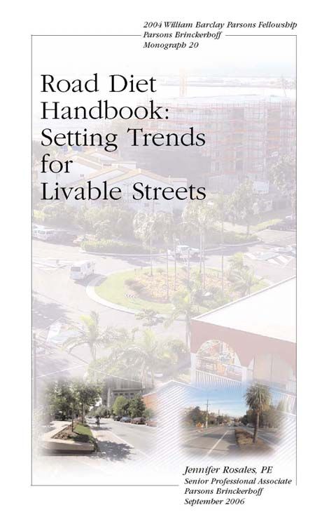
Supplementary Student Information
         Road Diet Handbook: Setting Trends for Livable Streets
The supplementary student information includes:
   • Introduction
   • References
   • Short biography of the author and instructor’s background and experience
   • Professional Development Fund donation form
   • Professional Development CD-ROM form
Road Diet Handbook - Overview
                            Jennifer A. Rosales, P.E., Professional Associate
                   PB PlaceMaking, 400 SW 6th Avenue, Suite 802, Portland, OR 97239
                         Email: rosales@pbworld.com and Phone: 503-478-2347

ABSTRACT
Under the William Barclay Parsons Fellowship program, Jennifer Rosales developed a comprehensive
handbook on “road diets,” called Road Diet Handbook: Setting Trends for Livable Streets. The handbook
assesses livability benefits which have not been previously evaluated including improved mobility for all
modes of transportation and enhanced street character and provides an overall best practice for the
implementation of road diets. The handbook advances the state-of-the-practice and provides a practical and
valuable tool for practitioners.

A “road diet” entails converting a four-lane undivided        Exhibit 1: Road Diet Handbook Cover
roadway to a two-lane roadway plus a two-way left
turn lane by removing a travel lane in each direction.
The remaining roadway width can be converted to bike
lanes, on-street parking or sidewalks. In cities
throughout the world, roadways have been put on “road
diets,” and these improvements have generated benefits
to all modes of transportation including transit,
bicyclists, pedestrians and motorists. These benefits
include reduced vehicle speeds, improved mobility and
access, reduced collisions and injuries, and improved
livability and quality of life.

This paper will summarize the findings from research
that the author conducted for the Road Diet Handbook:
Setting Trends for Livable Streets. The handbook is
intended to become a practitioner’s comprehensive
guide for decision-making on applicability of road
diets. It takes a practitioner through planning, analysis,
design, and implementation of road diet projects. It
includes guidelines for identifying and evaluating
potential road diet sites, design concepts such as typical
cross-sections, and lessons learned from experiences.
This paper will provide a summary and highlights from
the handbook.

INTRODUCTION
Increased traffic volumes on four-lane undivided
roadways degrade service and safety. In cities throughout the world, the livability of neighborhoods is
being improved by putting roadways on “road diets.” A road diet entails removing travel lanes from a
roadway and utilizing the space for other uses and travel modes. Improvements have generated benefits to
users of all modes of transportation, including transit riders, bicyclists, pedestrians and motorists.

The focus of the handbook is the road diet conversion of four-lane undivided roadways to two-lane
roadways plus a two-way left turn lane by removing a travel lane in each direction. The remaining

1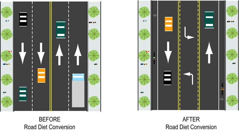
roadway width can be converted to bike lanes, on-street parking, landscaping, and/or sidewalks. The
resulting benefits include reduced vehicle speeds; improved mobility and access; reduced collisions and
injuries; and improved livability and quality of life.

Exhibit 2: Representative Road Diet

This handbook is intended to be used as a comprehensive guide for planners, engineers, and designers to
help them to make decisions on the applicability of road diets. Therefore, it contains information on
planning, analysis, design, and implementation, including:

•   Results from previous research efforts
•   Identification of significant gaps in the field
•   Analyses of safety and traffic operations
•   Livability considerations
•   Case study evaluations
•   Lessons learned from experience
•   Guidelines for identifying and evaluating potential road diet sites and design concepts such as typical
    cross-sections
•   Overall guidelines for implementation.

This handbook also evaluates the livability impacts of road diet projects, addressing such issues as comfort
and safety for pedestrians, bicycles, and transit users; increased landscaping and beautification
opportunities; and improved quality of life and street character.
To determine how specific road diet strategies affect livability, case studies of six sites (Vancouver,
Washington (two sites); Clear Lake, Iowa; Athens, Georgia; Toronto, Ontario, Canada; and Dunedin, New
Zealand) were analyzed. At each site:
•   A public opinion survey was administered along comparable four-lane undivided and three-lane streets
    either before or after road diet strategies were implemented.
•   Roadway and business activity data was collected both before and after the roadway was converted to
    further evaluate the livability, safety, and operational effects of road diets. The data collected included
    traffic volumes, vehicle speed and flow characteristics, collision rates and types, congestion, delay and
    queuing, cross-section design, existence of multimodal facilities, pedestrian crossings, and retail sales
    activity.

2
This research represents a state-of-the-practice analysis and provides a snapshot of the current state-of-the-
art in the implementation of roadway diets. Ultimately, however, each road diet project is unique to its
context, and its designers should strive to make the built, social and natural environment “better than
before.”

HANDBOOK ORGANIZATION
This monograph is divided into four chapters. Information is intended to provide guidance on planning,
analysis, design and implementation of road diets. It is also intended to provide information on the effects
of road diets, including safety, operational and livability benefits. Applicable local ordinances, design
requirements, and codes must be consulted for impacts to the planning and design process. A description
of each of the chapters follows:

Chapter 1 Introduction

Chapter 2 Previous Studies
This chapter summarizes the existing road diet research and literature, including studies of safety and
operational impacts of road diets. It includes citations of other literature that can be related to road diets,
such as pedestrian crossing safety studies. Gaps in the previous research are identified and summarized.
Chapter 3 Case Studies
This chapter includes case study examples of road diet projects that have been implemented at locations
around the world. Six sites in the United States and internationally were chosen for the survey and data
collection. For each case study, traffic, safety and survey data are analyzed to evaluate factors related to
the livability of these streets before and after the road diet was implemented. The methods used to collect
and analyze the survey data are described, and lessons learned are summarized.
Chapter 4 Practice Guidelines
This chapter will help practitioners identify and evaluate potential road diet candidate sites, by taking them
through the processes of planning, analysis, design and implementation of road diets. It includes general
recommendations for the planning, analysis, design, and implementation of road diets that take into account
the project context and site-specific conditions that need to be considered. This chapter includes:
• Guidelines for identifying and evaluating potential road diet sites
• General considerations including roadway characteristics and safety, operational and livability benefits
• An evaluation checklist
• Typical cross-sections for design concepts
• Implementation strategies

PREVIOUS STUDIES
This chapter summarizes previous research on road diets and includes safety and operational data from
these studies. Related research that supports road diets has been included in the literature review. An
example of such research is Safety Effects of Marked versus Unmarked Crosswalks, Federal Highway
Administration (FHWA) and University of North Carolina, which shows that collision rates are
significantly higher on multi-lane undivided roadways.1

Safety and operational studies under a variety of traffic volumes and roadway conditions are needed to
quantify the conditions for which road diets are appropriate2. This chapter also identifies gaps in the
previous research results as well as the significant gap in non-safety benefits, including livability benefits,
which have not been examined in past research. This chapter includes past studies on several types of road
diet projects.
3
This chapter is organized in the following sections and addresses:

    •   Economic Effects and Walkability
    •   Safety
    •   Operations
    •   Road Diet Project Types and Examples
    •   Lessons Learned
    •   Research Gaps

CASE STUDIES
This chapter, which illustrates the application of the road diet at six case study locations, includes
evaluations of factors related to the livability of the streets at each location. The road diet case studies are
diverse geographically and with respect to their surroundings, scale, character, function, and form.

Six case studies were chosen for the survey and data collection. The case study sites are in Dunedin, New
Zealand; Toronto, Canada; Athens, Georgia; Clear Lake, Iowa; and two in Vancouver, Washington. They
represent a wide range of project contexts from an urban street in Toronto, Canada to a rural street in Iowa
with varying project lengths, designs, and magnitude. Exhibit 3 shows the locations of the road diet case
studies.

Exhibit 3: Location of Road Diet Case Studies

Residents and businesses in the vicinity of each case study were surveyed to examine how a road diet
affects the livability of an area. The public opinion survey, which was modeled from surveys conducted by
Donald Appleyard in Livable Streets3, solicited information from people living and working adjacent to the
streets with factors directly related to its livability. The survey included questions on:
         •    Household/business characteristics
         •    Perceptions on the street’s traffic, safety, activities (street life) and friendliness
         •    Recommended improvements
         •    Reactions to the road diet

The surveys evaluated the livability impacts of road diet projects, addressing such issues as:
       •   Comfort and safety for pedestrians, bicyclists, and transit users
       •   Increased landscaping and beautification opportunities
       •   Improved quality of life and street character

4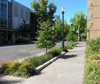
The results of the survey were intended to be used as an indication of livability factors for each case study.
The local agencies for the case studies were contacted for participation, and provided data for the project.

Exhibit 4: Case Studies

Fourth Plain Boulevard, Vancouver, Washington
Fourth Plain Boulevard is designated as a principal arterial, and serves a variety of transportation users,
including truck traffic through west Vancouver. Fourth Plain connects Interstate 5 to West Vancouver
neighborhoods, recreation, and industry, including the Port of Vancouver. Before the road diet project was
implemented on Fourth Plain Boulevard, this facility was designated a state truck route. When Fourth
Plain Boulevard was converted, a parallel facility, Mill Plain Boulevard, was converted to a truck route
bypass. This new bypass contributed to the success of the project by removing some truck traffic from
Fourth Plain Boulevard.

Exhibit 5: Fourth Plain Boulevard Lane Configuration – Before and After4

5       “Before” Road Diet                               “After” Road Diet
The purpose of the road diet conversion project on Fourth Plain Boulevard was to:
   • Cost-effectively enhance the environment for all street users while minimizing operational or
       spillover effects
   • Develop a safe and efficient transportation system
   • Reduce the crash frequency and number along the corridor
   • Improve pedestrian and bicycle mobility
   • Establish a balance between vehicle operations, port freight access and neighborhood livability
Livability Survey
In April 2004, an on-line web survey was used to solicit public input on livability. Most of the respondents
are pleased with the results of the road diet project on Fourth Plain Boulevard and have noticed
improvements to traffic, safety, and livability. The handbook provides survey findings for each case study.

Retail sales analysis found that the commercial area on, adjacent and near the Fourth Plain Boulevard road
diet project performed better than comparable areas in the City. 5 This growth occurred after the
implementation of the road diet project and during a recession that affected all portions of the City. When
comparing gross receipts before and after the road diet project, the commercial area in the Fourth Plain
project area had a positive increase of 3.1 percent compared to negative declines of -9.8 percent to -25
percent in two other comparable community commercial zones in the City.
Lessons Learned
    •   Safety improvements resulted from the implementation of the road diet with a significant reduction
        in crashes.
    •   The traffic operations along Fourth Plain Boulevard continued to operate adequately without
        queuing issues with improved operations for bicyclists and pedestrians.
    •   From the livability survey, the majority of the respondents concluded that the road diet has
        improved traffic issues.
    •   The livability survey suggests that the implementation of a road diet creates a street environment
        that is calmer and safer, although respondents don’t treat the street as a residential street (for
        example, not letting their children play in the street).
Baxter Street, Athens-Clarke County, Georgia
Baxter Street is located in Athens, Georgia and classified as an arterial and connects the University of
Georgia on the east to a major shopping center on the west. Baxter Street runs parallel to State Highway 78
and serves a variety of transportation uses.

The road diet project started as a safety demonstration project when Baxter Street needed resurfacing. The
purpose of the project was to:
    • Reduce the crash frequency along the corridor (especially       Exhibit 6: Baxter Street – After Road Diet
       rear-end and sideswipe)                                        (Courtesy of David Clark)
    • Increase travel flow by separating through vehicles from
       left-turning vehicles
    • Designate an area within the roadway for bicycle travel
    • Further separate vehicles from the sidewalk edge

Baxter Street has a 40-foot (12 m) right-of-way. The “before” and
“after” dimensions are as follows:
    • Before the road diet, the facility consisted of four 10-foot-
         wide lanes (3 m)
    • After the road diet, the facility consisted of two 14-foot-wide
         (4.2 m) lanes to be shared between vehicles and bicycles, and
         one 12-foot-wide (3.6 m) two-way left turn lane.

6
In the initial design, Baxter Street was considered too narrow for full bike lanes, so the 14-foot travel lanes
were striped with a dashed line to create an 11-foot travel lane and 3-foot shared vehicle/bike lane. In
2003, the 3-foot shared areas were striped as bicycle use only lanes. 6
Livability Survey
An online web survey was chosen for this case study to solicit public input to the livability survey. The
majority of respondents indicated that the street width is “just right” and that the number of travel lanes is
“just right.” Most also indicated that the street is “safe,” “very safe,” or “comfortable.” This response
indicates that the road diet project resulted in a positive change. The handbook provides complete survey
findings for each case study.
Lessons Learned
After the implementation of the Baxter Street road diet, Athens-Clarke County staff recommended the
following for road diet projects: 7
    • Add bus pull out bays, so buses don’t block through traffic
    • Include access management plans with appropriate spacing and/or eliminate driveways to reduce
        conflict points
    • Improve grates across catch basins to improve bike operations (e.g., improve stormwater collection
        systems to remove water from curb lanes where bikes travel)
    • Repair sidewalks and driveways in poor condition
    • Improve landscaping to “soften” the corridor
    • Coordinate with other corridor improvements
US 18, Clear Lake, Iowa
U.S. 18 is a state highway in Iowa and the primary east-west route through the City of Clear Lake.
Railroad tracks run parallel to U.S. 18 on the south side. U.S. 18 serves traffic traveling in, through, and
out of Clear Lake, and serves a variety of transportation uses in Clear Lake, including freight movement.
U.S. 18 provides access to the downtown business and tourist area.

The U.S. 18 road diet project consisted of simply re-striping the highway with the road conversion,
installing one traffic signal, and upgrading an existing traffic signal. A second phase of the project will
include the installation of right turn lanes at key intersections along the corridor. Before the conversion,
U.S. 18 was a four-lane undivided roadway. It was converted to two lanes plus a two-way left turn lane
and painted shoulders. The purpose of this project was primarily to improve safety along the corridor.
Livability Survey
A door-to-door survey method was used for the US 18 case study to solicit public input to the livability
survey. The respondents indicated that they would like more lanes to travel faster and to relieve some
congestion during the peak hour. However, these respondents also think that speeding remains a problem at
times. The respondents would like to see more police enforcement to slow speeds and keep motorists from
using the center turn lane as a passing lane. The handbook provides the survey findings for each case study.
Lessons Learned
The project was implemented primarily to improve safety, and an assessment of crash statistics indicates
that safety has improved. However, many respondents believe that the road is less safe following the initial
phase of the road diet implementation. There may be a number of reasons for this perception including the
unclear lane striping, misuse of the center turn lane, and several complementary improvements still to be
added to the project, including improved signal timing and right turn lanes. Depending on the level of
community acceptance of the project, a public involvement/education effort may be beneficial to show the
resulting safety benefits of the project.

7
The cost of a road diet project can be minimal by simply re-striping a roadway, and it can be completed as
an interim solution or as a pilot project for a short length of time, such as 6 months. By implementing a
road diet as a pilot project study, the effects on safety and operations can be measured before deciding
whether to keep it permanently and/or whether to fund enhanced design features and a more permanent
solution. When evaluating a temporary solution, it is important to note that it may not provide all of the
benefits of a permanent solution.

On U.S. 18, the transition areas from the four-lane to two-lane section with two-way left turn lane is
confusing for drivers, and the survey respondents indicated that better lane markings are needed. A lesson
learned for a pilot project or re-striping project is to ensure that the lane markings are clear and that the old
lane markings are not still visible. Both the road diet pilot project and interim solution can be enhanced by
adding landscaping, signal timing improvements, sidewalk connectivity, improved pedestrian crossings,
and other enhanced design features.
St. George Street, Toronto, Ontario, Canada
St. George Street, a multimodal street through the St. George campus of the University of Toronto, was put
on a road diet in the 1990s. St. George Street is classified as a minor arterial road by the City of Toronto
and serves vehicles, delivery trucks, bicyclists, pedestrians and even skateboarders. An extremely high
number of pedestrians use St. George Street, and continuous sidewalks on both sides of the street are
provided in the pedestrian zones.

St. George Street road diet project was completed in 1996, about 8 years before this study. The project was
incrementally enhanced beginning in 1993, with the most significant construction occurring in 1996. Prior
to 1993, the street operated as a four-lane road during peak hours and as a two-lane road with on-street
parking permitted during non-peak hours. In 1993, the number of lanes on St. George Street was reduced
to two by permitting parking during all hours. Bicycle lanes, a narrow painted median, and turn lanes were
provided at key intersections as part of the lane reduction project. The road diet project also narrowed the
pavement width and reconstructed the curbs along St. George Street in 1996. Before the road diet project,
the pavement width was wide considering the street function and surroundings. As part of the road diet
project, the pavement width was narrowed from 46 feet (14 meters) to a varying width of 31 to 40 feet (9.5
to 12.2 meters). The sidewalk area was widened to increase the pedestrian zone.

The narrowing of the pavement and widening of the sidewalk has significantly enhanced pedestrian
crossing areas. The majority of the pedestrian crossings occur at uncontrolled mid-block locations that
correspond to campus pedestrian routes. To delineate the mid-block crossing areas, alternative roadway
pavement materials were used to highlight these crossing areas.

Curb extensions at specific locations in coordination with on-street parking have reduced vehicle travel
speeds. By narrowing the pedestrian crossing areas, pedestrians have been encouraged to cross at specific
locations with shorter crossing distances. Landscaping has been added to provide a buffer and enhanced
urban environment to the road diet project. Exhibit 7 provides photographs of St. George Street.

Exhibit 7: St. George Street – After Road Diet

8
Livability Survey
A web survey was used to solicit public input on the livability of the street. The survey respondents
indicated satisfaction with the street width and number of lanes, but some respondents indicate a desire to
remove all cars. The survey respondents recognized the benefits that the road diet project has produced,
including slower speeds and improved safety, but still desire further improvements such as more
crosswalks and more greenery. The respondents desire additional aesthetic enhancements such as greenery
and replacement of concrete planters, cobblestones and pavers. The handbook provides complete survey
findings for each case study.
Lessons Learned
A road diet project through an urban University setting has both perceived benefits by users of all
transportation modes and actual measured safety and operational benefits as well. An urban, university
environment is an ideal location to consider a road diet project because of the high number of pedestrians
and bicyclists that benefit from projects of this type.
Kaikorai Valley Road, Dunedin, New Zealand
Kaikorai Valley Road is located in Dunedin, New Zealand, which is an eastern coastal City in New
Zealand. Kaikorai Valley Road is classified as a Regional Arterial road which is defined by the Dunedin
City District Plan as one that serves as a link of strategic importance between or within regions, and
between districts. Kaikorai Valley Road serves as an alternate route into and out of the Dunedin central
business district from the south. Kaikorai Valley Road serves a variety of transportation uses, and parking
is provided on both sides of the road.

The road diet project on Kaikorai Valley Road was completed in 2003, about one year before this study.
The length of the road diet project is 2.4 kilometers (1.5 miles), on the northern end of Section 2 of
Kaikorai Valley Road. The road diet project entailed reducing Kaikorai Valley Road (section 2) from a
four-lane roadway with on-street parallel parking to a two-lane roadway with on-street parking and cycle
(bicycle) lanes. The project included:

    •   Planting the existing median with low growing shrubs
    •   Improving pedestrian crossings by converting a crossing to a pedestrian crossing point,
        constructing disabled crossing ramps and installing floodlighting.
    •   Upgrading an existing pedestrian crossing by installing floodlighting.
    •   Extending the length of turn pockets to accommodate queuing vehicles without impeding the flow
        of through traffic.

Exhibit 8: Kaikorai Valley Road – After Road Diet (Courtesy of Ron Minnema, City of Dunedin, NZ)

9
Livability Survey
A door-to-door survey method was used for the Kaikorai Valley Road project to solicit public input to the
livability survey. The respondents had mixed perceptions regarding the results of the project, but still
almost half recommended this project to other streets in the City. The handbook provides complete survey
findings for each case study.
Lessons Learned
The following summarizes the lessons learned for the Kaikorai Valley Road Case Study:
• Safety improvements for all transportation modes resulted from the implementation of the road diet
with a significant reduction in traffic speeds and crashes.
• The traffic operations continued to operate adequately with no traffic diversion impacts.
• From the livability survey, the majority of the respondents on Kaikorai Valley Road concluded that
the road diet has resulted in positive transportation improvements.
Grand Boulevard, Vancouver, Washington
This case study differs from the other case studies in that the roadway was surveyed before the
implementation of a road diet project. Grand Boulevard, an undivided four-lane arterial located in the City
of Vancouver, Washington, is an example of an ideal road diet candidate. The City of Vancouver has been
challenged by neighborhoods and special interest groups to re-assess the operational and capacity needs on
many undivided four-lane corridors. The motivations behind these requests are varied, and often revolve
around the perceived trade-off between transportation capacity and community livability.
Livability Survey
Overall, the survey respondents seemed as or more concerned with non-traffic issues such as aesthetics and
crime. Perceptions of safety were correlated with perceptions of traffic speed, as respondents who felt the
street is unsafe tended to say that traffic moves too fast. The handbook provides complete survey findings
for each case study.
Recommendations
Grand Boulevard is an ideal facility for a road diet project, and the City of Vancouver plans to convert it to
a two-lane with center left-turn lane facility as funding becomes available. The City of Vancouver plans to
study Grand Boulevard after the road diet project is constructed to evaluate its effectiveness.
Recommendations for a road diet project on Grand Boulevard include the following:
• Re-stripe roadway from a four lane roadway to a two lane roadway with a center left-turn lane or
median channelization (minimum 11 feet width for center turn lane).
• Provide a dedicated bike lane in both directions.
• Institute a speed monitoring and enforcement program to reduce vehicle speeds.
• Improve pedestrian facilities by adding curb ramps, crosswalks, lighting, and sidewalks where
needed to provide connectivity, comfort and safety.
• Implement the road diet project with pavement overlay of street.
10Case Studies Summary
Exhibit 9: Road Diet Impacts
Safety
Significant safety benefits resulted from the road diet projects. The overall number crashes were reduced
by the road diet case study projects ranging from a 10 % to 65 % reduction. Also, traffic speeds were
reduced at the case study locations as a result of the road diet projects. The safety impacts of the road diet
case studies are summarized as follows.
On Fourth Plain Boulevard, Vancouver, Washington, the safety impacts resulting from the road diet project
follow: 8
Number of reported collisions along Fourth Plain Boulevard decreased by 52 % after the road diet
project was constructed.
Pedestrian safety improved and there were no reported pedestrian collisions along Fourth Plain
Boulevard after the road diet project compared to six reported pedestrian collisions for the three
years prior to the road diet project.
Traffic speeds along Fourth Plain Boulevard have decreased about 18 % after the road diet project
was constructed from 29.4 miles per hour to 24.2 miles per hour.
On Baxter Street in Athens-Clarke County, Georgia, the road diet project resulted in the following safety
impacts: 9
The reported number of crashes was reduced by 53 % from the implementation of the road diet
project.
The reported number of crashes at unsignalized locations was reduced by 60 %.
11 The number of rear-end crashes were significantly reduced by 45 % since left turning vehicles have
a center turn lane to use instead of stopping in the through lane.
On U.S. 18 in Clear Lake, Iowa, the safety impacts resulting from the road diet project follow: 10
Number of crashes per year was decreased by 65 % from 40 crashes per year “before” to 14 crashes
per year “after” the project was implemented.
Travel speeds have been reduced with before and after speed data showing a 52 % reduction in
aggressive speeding. In addition, the number of vehicles driving over the speed limit was reduced
by 32 % after the road diet project.
On St. George Street, Toronto, Canada, significant safety improvements were realized as a result of the
11
road diet lane reduction and narrowing project which follow:
The number of collisions was estimated to be reduced by about 40 % from the reduction of lanes
on St. George Street, from about 33 collisions per year “before” the lane reduction to about 20
collisions per year “after” the lane reduction.
By narrowing the pavement and lane widths on St. George Street, the number of collisions was
further reduced to about 19 collisions per year for the six years following the pavement and lane
width narrowing.
On Kaikorai Valley Road, Dunedin, New Zealand, safety benefits were also achieved from the road diet
12,13
project which follows:
The road diet project on Kaikorai Valley Road resulted in a 30 % crash reduction from 10 crashes
per year “before” the road diet project to about 7 crashes per year “after” the road diet project was
implemented.
The traffic speeds along Kaikorai Valley Road were also reduced after the road diet project was
implemented. Approximately 88 % of the speeds “before” the road diet project exceeded 50
kilometers per hour (30 mph) compared to approximately 69 % of the speeds “after” the road diet
project exceeded 50 kilometers per hour.
Despite the diverse settings, in all five case study sites where the road diet was implemented, the number of
crashes decreased and measured speeds decreased resulting in significant safety improvements.
Operations
As shown from the case studies, there were no significant changes to traffic volumes on the road dieted
streets. In addition, no significant traffic diversion impacts were found as well. The road dieted streets
continued to operate adequately without significant queuing and operational impacts. For several road diet
projects, pedestrian and bicycle activities were measured and observed as a result of the road diet projects.
Also, improved pedestrian and bicycle conditions resulted from the projects. The operational impacts of
the road diet case studies are summarized in this section.
On Fourth Plain Boulevard, the traffic operational impacts after the road diet project implementation
follow: 14
No significant negative impacts to the traffic operation including no reports of queuing vehicles
interrupting adjacent business and residential access on Fourth Plain Boulevard.
Bicyclists and pedestrian activity have increased. The bicycle operational safety along the corridor
has improved, and the bicycle level of service has improved significantly since the road diet project
was implemented.
Other operational benefits such as the bicycle lane providing space for police enforcement and a
refuge area for vehicles temporarily broken down.
There was no significant traffic diversion as part of the Fourth Plain Boulevard road diet project.
12On Baxter Street, the traffic operational impacts resulting from the road diet project follow: 15
No significant impacts to the traffic volumes on Baxter Street or on adjacent streets after the road
diet conversion project.
Traffic diversion experienced from the project to be about 4 % of the Baxter Street traffic to Broad
Street, a parallel arterial street north of Baxter Street.
After the road diet project, the traffic operation along U.S. 18 remained acceptable with good mobility.
The resultant operating speeds were more uniform and closer to the posted speed limit. 16
On St. George Street in Toronto, Canada, the road diet project resulted in the following traffic operational
17
impacts:
Adequate traffic operations continue along St. George Street.
Increase in pedestrians and bicyclists
Traffic volumes along St. George Street have remained relatively consistent before and after the
narrowing of the travel lanes as part of the road diet project from 7,300 vehicles per day in 1994 to
about 7,400 vehicles per day in 2003.
No traffic diversion impacts.
On Kaikorai Valley Road in Dunedin, New Zealand, the traffic operations resulting from the road diet
18
project follow:
Adequate traffic operations continue along Kaikorai Valley Road.
Traffic volumes have not been impacted from the road diet project and remained relatively
constant. In addition, the vehicle classification and % trucks remained relatively constant.
The traffic volumes show a small amount of growth which indicates that traffic diversion was not
experienced from the road diet project on Kaikorai Valley Road.
At all locations, impacts to overall traffic operations were negligible if not positive.
Lessons Learned
The following section summarizes the lessons learned from the road diet case studies:
• Consider road diet projects when multiple opportunities arise such as a pavement reconstruction
project, presence of an adjacent parallel route, and jurisdictional roadway transfer.
• Consider community requests to evaluate and implement road diet projects. With technical
evaluation and community involvement with stakeholder groups, road diet projects are more likely
to be successful.
• A public education campaign that goes along with a road diet project needs to emphasize the notion
that this is a safety enhancement project and that it may require trade-offs in capacity and speed.
Increase public education regarding the use of the two-way left turn lane.
• Manage community expectations with clear communication and documentation. Identify project
goals, performance measures, expectations and conduct follow-up evaluation.
• Coordinate road diet projects with concurrent pavement overlay projects, if possible. A road diet
striping plan on new pavement results in less driver confusion.
• By implementing a road diet as a pilot project study, the effects on safety and operations can be
measured before deciding whether to keep it permanently and/or whether to fund enhanced design
features and a more permanent solution. A temporary solution may not provide all of the benefits
that a permanent solution would provide.
• Add bus pull out bays when needed.
• Include access management plans with appropriate spacing and/or elimination of driveways to
reduce conflict points.
• Improve storm water grates across catch basins to improve bike operations.
• Repair sidewalks, ramps, and driveways in poor condition.
• Improve landscaping to “soften” the corridor.
13• Coordinate with other corridor improvements.
• Install a grass median or other median treatment.
• Increase police enforcement of speeds and the proper use of the center turn lane.
Both the road diet pilot project and interim solution can be enhanced by adding landscaping, signal timing
improvements, sidewalk connectivity, improved pedestrian crossings, and other enhanced design features.
Safety, operational and livability benefits result for all modes of transportation from the implementation of
road diet project as seen from the case studies in this handbook.
ROAD DIET GUIDELINES
Great streets rarely happen by accident; great streets require vision and knowledge to make them happen.
Road diets, when implemented properly and in the appropriate context, can enhance the livability of a street
and contribute to the traits that can make a street great. This chapter provides guidance to the practitioner
regarding how to determine if a street is a good candidate for a road diet, and best practices for road diet
implementation.
When determining the appropriateness of a road diet conversion project, the project context and site-
specific conditions such as traffic flow characteristics, vehicle capacity, traffic operations, safety,
environmental impacts (social, built, and natural), and livability need to be considered.
This chapter will help practitioners identify and evaluate potential road diet candidate sites by taking them
through the processes of planning, analysis, design and implementation of road diets. It includes general
recommendations for road diets that take into account the project context and site-specific conditions that
need to be considered. This chapter includes:
• Guidelines for identifying and evaluating potential road diet sites
• Feasibility factors
• Design guidelines and considerations
• Typical cross-sections for design concepts
• “Greening” road diet options
• Other considerations
Identification and Evaluation of Potential Road Diet Candidates
A road diet project can improve walkability and community livability and economics. The road diet is an
alternative to widening the cross-section of roadway and, when appropriate, it can have lower overall
impacts than widening the roadway, be a more cost-effective option, and result in acceptable operations and
improved safety.
Recent research has recommended that road diet conversion should be evaluated in terms of safety and
operation effects, especially vehicle speeds, congestion, traffic volume and traffic flow. Road diet
conversions should be made on a case-by-case basis considering traffic flow, vehicle capacity, and safety
goals.19 Each potential road diet implementation should identify, compare and analyze all feasible
alternative improvements that meet the project goals and objectives.
Feasibility Factors
Several feasibility factors were identified in research conducted by Knapp to evaluate the feasibility of road
diets: 20
• Roadway Function and Environment
• Overall Traffic Volume and Level of Service
• Turning Volumes and Patterns
14• Frequent-Stop and Slow-Moving Vehicles (Agriculture, Buses, Mail, Buggies)
• Weaving, Speed, and Queues
• Crash Types and Patterns
• Pedestrian and Bicycle Activity
• Right-of-Way Availability, Cost, and Acquisition Impacts
• Presence of Parallel Routes
• Other Contextual Considerations
Road Diet Design Solutions
This section in the handbook provides a tool box for design of road diet projects, including optional
enhancements such as landscaped medians, improvements to pedestrian crossings and facilities, street trees
and curbside planters, improved transit user facilities, and green street options. For cost-effectiveness and
natural resource conservation, road diet projects can be designed and constructed by simply re-striping the
roadway and re-using the existing pavement width and curbs.
A context-sensitive solutions approach is recommended for potential road diet projects. From Thinking
beyond the Pavement, Maryland State Highway Administration Workshop, 1998 – “Context sensitive
design asks first about the purpose and need of the transportation project, and then equally addresses
safety, mobility, and the preservation of scenic, aesthetic, historic, environmental, and other community
values. Context sensitive design involves a collaborative, interdisciplinary approach in which citizens are
part of a design team.”
It is important to recognize that every project is unique. Design solutions for road diet project alternatives
need to:
Provide a safe and efficient transportation corridor for vehicles, buses, bicycles and pedestrians.
Balance the needs of the transportation system with the interests of the surrounding community and
the environment
Create a transportation facility that is an asset to the community
Road diet project objectives could include:
Improved safety and operations
Enhanced neighborhood character
Improved access to businesses, transit, parks, etc.
Preserved and improved environmental conditions throughout project limits by reducing pavement
area and treating water run-off
Design Concepts
Street design is a key element of smart growth development and directly affects quality of life. Designers
are encouraged to integrate streets closely with planned land use. From Metro’s (regional government
agency for Portland Metro, Oregon, U.S.) document, Creating Livable Streets21:
“A livable regional street should provide those environmental conditions that support
independence and freedom of choice; provide orientation, safety and comfort; encourage a sense
of community yet provide sufficient privacy; foster a sense of neighborly ownership and
responsibility; avoid disturbing nuisances; and enhance the economic value of adjacent property.”
The road diet design concepts presented in this chapter are focused on the conversion of a four-lane
undivided roadway to a two-lane roadway. A center turn lane is recommended when driveways are
present, and a landscaped center median in areas where driveways are uncommon or absent. The
remaining roadway width can be converted to bike lanes, on-street parking, landscaping, sidewalks, and/or
turned back to the property owners.
15A Policy on the Geometric Design of Highways and Streets (Green Book) published by the American
Association of State Highway and Transportation Officials (AASHTO) provides geometric design criteria
for roadways. As noted in the Foreword (2004), “The intent of this policy is to provide guidance to the
designer by referencing a recommended range of values for critical dimensions. It is not intended to be a
detailed design manual that could supercede the need for the application of sound principles by the
knowledgeable design professional. Sufficient flexibility is permitted to encourage independent designs
tailored to particular situations.”22
The road diet design concepts presented in the handbook complement the AASHTO guidelines.
Traveled Way
The handbook provides general design parameters for major urban arterial and collector thoroughfares with
varying contexts. General guidance on dimensions and cross-section elements criteria, including lane
widths, is included for urban streets with two to four through lanes.
Travel lane and turn lane widths can vary depending on the project context, land use, modal use, and speed
from a minimum of 10 feet to 14 feet (3 m to 4.3 m).
Suggested Left-Turn Treatments for Road Diet Streets
Based on previous research, the handbook provides guidance on the selection of left-turn treatments for
specific conversion alternatives and factors.
Transitions
When the number of travel lanes is reduced and/or width of the street is changed, a smooth transition needs
to occur. The principles for designing effective transitions include:23
• Properly design, stripe, and sign geometric transitions using established guidance (Manual on
Uniform Traffic Control Devices (MUTCD), AASHTO).
• Transitions should occur on a tangent roadway section and avoid areas with horizontal and vertical
sight distance constraints.
• Entire transition length should be visible to the driver.
• When roadways widen or lanes are added, a transition taper of 10:1 is sufficient.
• Transitions to left or right turn lanes typically require a shorter taper. AASHTO recommends 100
feet (30.5 m) for single turn lanes.
It should be noted that choosing the transition locations for road diet projects needs special attention and
thorough evaluation. Major driveways and intersections should be avoided along a transition. Intersection
and roundabout locations can be ideal beginning transition locations to drop lanes.
Bicycle Facilities
Bicycle travel is an important element of multimodal, livable streets. Bike lanes are practical and often
essential for road diet projects. They not only improve the bicycling environment, but also provide a buffer
to pedestrians. In addition, bike lanes allow space for vehicles to temporarily store while emergency
vehicles pass, they add to turning radii, and they improve sight lines. Important sources for bicycle facility
design and treatments are the AASHTO Guide for the Development of Bicycle Facilities24, ITE Innovative
Bicycle Treatments25, and the MUTCD26.
General considerations for bicycle facilities are:
• Smooth surfaces are needed for safety and comfort of bicyclists.
• Regular maintenance and street sweeping are required and pavement should be free of large cracks
and potholes.
• Curb inlets for drainage or bicycle-safe inlet grates should be provided.
16Recommended lane widths for bicycle lanes and typical lane marking for bicycle lanes are presented in the
handbook.
On-Street Parking
On-street parking provides a buffer to pedestrians from traffic and is found to decrease traffic speeds. In
addition, on-street parking meets the needs of adjacent land uses and stimulates street activity. On-street
parking should be implemented based on project context, traffic volume and speed, adjacent land uses, and
local parking management plans and policies.
General considerations for on-street parking are:27
• Parallel parking should be considered on urban arterials and collectors.
• Angled parking may be considered on low-speed and low-volume commercial collectors and main
streets.
• On-street parking should not be considered on major streets with speeds greater than 35 miles per
hour due to potential maneuvering conflicts.
• Consider the use of a curb lane for on-street parking during off-peak hours when traffic capacity
needs to be balanced with on-street parking needs.
• Provide a minimum of 1.5-foot (0.46 m) offset between face of curb and edge of potential
obstructions such as poles and trees.
• Parking should be prohibited within 20 feet (6.1 m) of fire hydrants or per local codes.
• Parking should be at least 20 feet to 50 feet (6.1 m to 15.2 m) from midblock crosswalks and at
least 20 feet (6.1 m) from the curb return of intersections (30 feet (9.1 m) for signalized
intersections). Curb extensions can be used to reduce this distance.
Pedestrian Realm
Streets have multiple uses and appropriate solutions should be selected to improve pedestrian safety and
access. In addition, walkable streets promote healthy communities and safe neighborhoods. Sidewalks are
important elements of street design. Key attributes of good sidewalk corridors are:28
• Accessibility
• Adequate travel width
• Safety
• Continuity
• Landscaping
• Social space for people to interact
• Quality of place to strengthen the character of neighborhoods and business districts
When implementing a road diet conversion project, the following are key issues/actions to be addressed
and/or undertaken:
• Identification of pedestrian crossing locations and exposure to potential hazards.
• Identification of missing sidewalks or pathways
• Identification of transit zones and stop locations and provision of adequate pedestrian access.
• Both pedestrian and bicycle facilities need to be designed to be compatible with and facilitate
transit use.
• Design and maintenance of landscaping to provide good visibility between pedestrians and
approaching vehicles.
• Provision of adequate lighting for pedestrian safety at night.
• Comfortable sidewalks for pedestrians, with a minimum width of 5 feet, and maintained routinely.
Other sources for effective design of pedestrian facilities include: ITE Alternative Treatments for At-Grade
Pedestrian Crossings29, Safety Effects of Marked vs. Unmarked Crosswalks at Uncontrolled Locations for
FHWA30, ITE Design and Safety of Pedestrian Facilities31, and AASHTO’s Guide for Planning, Design
17and Operation of Pedestrian Facilities32. Pedestrian facilities need to be accessible to all users, and in the
U.S. meet the requirements of the Americans with Disabilities Act (ADA), and an additional resource is the
United States Access Board’s Draft Guidelines for Accessible Public Rights-of-Way33.
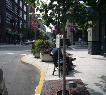
Exhibit 10: Curb Extension
Guidelines for installing marked crosswalks and other needed
pedestrian improvements at uncontrolled (unsignalized) locations are
provided in the handbook. To reduce the effective street crossing
distance for pedestrians, the following design options can be
considered:
• Narrow the street width,
• Provide curb extensions, and/or
• Add raised pedestrian refuge islands at intersections.
Pedestrian refuge islands as raised medians can be added at
intersections between center left turn lanes, if designed appropriately.
Typical Road Diet Cross-Sections (Two-Lane Streets)
Several road diet cross-sections are provided in the handbook for
reference. The selection of cross-sectional elements is project-specific. The width of street, travel lanes,
bike lanes, on-street parking, sidewalk, and landscape areas can be adjusted within the right-of-way. These
decisions will likely be based on modal priorities, adjacent land uses and speeds, and should be made on a
case-by-case basis, and may vary along a project corridor.
Exhibit 11: Example Road Diet Cross-Section with Median/Turn Lane, Bike Lanes,
Landscaping and Sidewalks
Streetscaping may be initiated by a community visioning or planning process that establishes guidelines for
streetscape design. Implementation may involve special published guidelines, plans and funding for
streetscape improvements on a particular street or in an area.
Streetscape improvements can also be incorporated into subdivision and roadway design standards, for
example, by encouraging or requiring shorter blocks, wider sidewalks, bike lanes, narrower streets,
landscaping, and other features that improve accessibility, walkability and aesthetics.
Traffic Calming Options
Traffic calming measures can be implemented as part of road diet projects. The ITE Traffic Calming State
of the Practice34 provides traffic calming options that can be considered. The handbook presents examples
of traffic calming measures.
18In addition to the above traffic calming examples, roundabouts can be used for intersection traffic control to
both slow traffic speeds and keep traffic moving. The FHWA Roundabouts: An Information Guide35 is an
important resource to use when considering the implementation of a roundabout. Roundabouts have also
been used to serve as transition points between three- or two-lane street segments and four-lane segments.
Green Streets
A green street meets the transportation need and Exhibit 12: Green Street with Bio-Filtering
applies environmental stewardship to improve the Stormwater Planter/Bio-Swale and Unit Pavers
natural, built and social environments. A few
examples of green street design solutions are provided in this
chapter of the handbook as optional enhancements for the road
diet application.
As identified in Metro’s (regional government agency for
Portland Metro, Oregon, U.S.) Green Streets Handbook36, the
appropriate green streets design solutions and/or combination of
solutions depends on the desired functions (e.g., runoff
reduction, detention, retention, conveyance and water quality
mitigation) and site/watershed conditions.
ACKNOWLEDGMENTS
This research was funded by the PB William Barclay Parsons Fellowship. Jennifer’s Foreword and
Acknowledgments are provided in the handbook.
END NOTES
1
Zegeer, C.V., J.R. Stewart, H.F. Huang, and P. Lagerwey. Safety Effects of Marked vs. Unmarked Crosswalks at Uncontrolled
Locations, Executive Summary and Recommended Guidelines. Report No. FHWA-RD-01-075, Federal Highway Administration,
U.S. Department of Transportation, February 2002.
2
Huang, H., Stewart, R., and Zegeer, C., Evaluation of Lane Reduction “Road Diet” Measures on Crashes and Injuries,
Transportation Research Record 1784, Paper No. 02-2955, 2002.
3
Appleyard, D., Livable Streets, University of California Press, 1981.
4
Photographs provided by Todd Boulanger, City of Vancouver, 2004.
5
City of Vancouver, Washington. Draft Post Implementation Report for Fourth Plain Boulevard Re-Striping Project, June 2004.
6
Clark, D. Road Diets: Athens-Clarke County’s Experience in Converting 4-lane Roadways into 3-lane Roadways, Institute of
Transportation Engineers Annual Meeting, 2001.
7
Clark, D. Road Diets: Athens-Clarke County’s Experience in Converting 4-lane Roadways into 3-lane Roadways, Institute of
Transportation Engineers Annual Meeting, 2001.
8
City of Vancouver, Washington. Draft Post Implementation Report for Fourth Plain Boulevard Re-Striping Project, June 2004.
9
Clark, D. Road Diets: Athens-Clarke County’s Experience in Converting 4-lane Roadways into 3-lane Roadways, Institute of
Transportation Engineers Annual Meeting, 2001.
10
Data provided by Tom Welch and Tim Simodynes, Iowa Department of Transportation, 2004.
11
Data provided by Nazzareno Capano, City of Toronto, Canada 2004.
12
Data provided by Ron Minnema, City of Dunedin, New Zealand, 2004.
13
Crash data provided by the Land Transport Safety Authority, Dunedin, New Zealand, 2004.
14
City of Vancouver, Washington. Draft Post Implementation Report for Fourth Plain Boulevard Re-Striping Project, June 2004.
15
Clark, D. Road Diets: Athens-Clarke County’s Experience in Converting 4-lane Roadways into 3-lane Roadways, Institute of
Transportation Engineers Annual Meeting, 2001.
16
Data provided by Tom Welch and Tim Simodynes, Iowa Department of Transportation, 2004.
17
Data provided by Nazzareno Capano, City of Toronto, Canada 2004.
18
Data provided by Ron Minnema, City of Dunedin, New Zealand, 2004.
19
Huang, H., Stewart, R., and Zegeer, C., Evaluation of Lane Reduction “Road Diet” Measures on Crashes and Injuries,
Transportation Research Record 1784, Paper No. 02-2955, 2002.
20
Knapp, Keith, and K. Giese, Guidelines for the Conversion of Urban Four-Lane Undivided Roadways to Three-Lane Two-Way
Left-Turn Lane Facilities Final Report, Center for Transportation Research and Education, Iowa State University, April 2001.
21
Creating Livable Streets, Street Design Guidelines for 2040, METRO, June 2002.
1922 A Policy on Geometric Design of Highways and Streets, AASHTO, 2004. 23 Context Sensitive Solutions in Designing Major Urban Thoroughfares for Walkable Communities, An ITE Proposed Recommended Practice, Institute of Transportation Engineers, 2006. 24 Guide for the Development of Bicycle Facilities, AASHTO, Washington, DC, 1999. 25 Innovative Bicycle Treatments: An Information Report, Institute of Transportation Engineers, Washington, DC, 2002. 26 Manual on Uniform Traffic Control Devices for Streets and Highways, Federal Highway Administration, Washington, DC, 2003. 27 Context Sensitive Solutions in Designing Major Urban Thoroughfares for Walkable Communities, An ITE Proposed Recommended Practice, Institute of Transportation Engineers, 2006. 28 Portland Pedestrian Design Guide, City of Portland, June 1998. 29 Alternative Treatments for At-Grade Pedestrian Crossings, Informational Report, Institute of Transportation Engineers, 2001. 30 Zegeer, C.V., J.R. Stewart, H.F. Huang, and P. Lagerwey. Safety Effects of Marked vs. Unmarked Crosswalks at Uncontrolled Locations, Executive Summary and Recommended Guidelines. Report No. FHWA-RD-01-075, Federal Highway Administration, U.S. Department of Transportation, February 2002. 31 Design and Safety of Pedestrian Facilities, Institute of Transportation Engineers, March 1998. 32 Guide for the Planning, Design and Operation of Pedestrian Facilities, AASHTO, Washington, DC, 2004. 33 Draft Guidelines for Accessible Public Rights-of-Way, United States Access Board, 2005. 34 Ewing, R., Traffic Calming State of the Practice, Institute of Transportation Engineers, FHWA-RD-99-135, 1999. 35 Roundabouts: An Informational Guide, Federal Highway Administration, FHWA-RD-00-67, 2000, Washington, DC. 36 Green Streets, Innovative Solutions for Stormwater and Stream Crossings, METRO, June 2002. 20
You can also read