Role of Flooding Patterns in the Biomass Production of Vegetation in a Typical Herbaceous Wetland, Poyang Lake Wetland, China - Frontiers
←
→
Page content transcription
If your browser does not render page correctly, please read the page content below
ORIGINAL RESEARCH
                                                                                                                                           published: 16 October 2020
                                                                                                                                        doi: 10.3389/fpls.2020.521358

                                             Role of Flooding Patterns in the
                                             Biomass Production of Vegetation in
                                             a Typical Herbaceous Wetland,
                                             Poyang Lake Wetland, China
                                             Xue Dai 1,2* , Zhongbo Yu 1,2* , Guishan Yang 3,4* and Rongrong Wan 3,4*
                                             1
                                               State Key Laboratory of Hydrology–Water Resources and Hydraulic Engineering, Hohai University, Nanjing, China, 2 College
                                             of Hydrology and Water Resources, Hohai University, Nanjing, China, 3 Key Laboratory of Watershed Geographic Sciences,
                                             Nanjing Institute of Geography and Limnology, CAS, Nanjing, China, 4 University of Chinese Academy of Sciences, Beijing,
                                             China

                                             Flooding is an important factor influencing the biomass production of vegetation in
                                             natural wetland ecosystems. However, how biomass production is linked to flooding
                                             patterns in wetland areas remains unclear. We utilized gauging station data, a digital
                                             elevation model, vegetation survey data, and a Landsat 8 image to study the effects
                       Edited by:
                   András Zlinszky,          of average inundation depth (AID) and inundation duration (IDU) of flooding on end-of-
    Hungarian Academy of Sciences,           season biomass of vegetation in Poyang Lake wetland, in particular, after operation
                          Hungary
                                             of Three Gorges Dam. The end-of-season biomass of wetland vegetation showed
                      Reviewed by:
                        Péter Török,
                                             Gaussian distributions along both the AID and IDU gradients. The most favorable
    University of Debrecen, Hungary          flooding conditions for biomass production of vegetation in the wetland had an AID
                    Amber Churchill,         ranging from 3.9 to 4.0 m and an IDU ranging from 39% to 41%. For sites with a lower
 Western Sydney University, Australia
                                             AID ( 41%), the end-of-season biomass
                      zyu@hhu.edu.cn         values were negatively related. After the operation of the Three Gorges Dam, flooding
                       Rongrong Wan
                   rrwan@niglas.ac.cn
                                             patterns characterized by AID and IDU of the Poyang Lake wetland were significantly
                              Xue Dai        alleviated, resulting in a mixed changing trend of vegetation biomass across the
                  daixue@hhu.edu.cn          wetland. Compared with 1980–2002, the increase of end-of-season biomass in lower
                        Guishan Yang
                 gsyang@niglas.ac.cn         surfaces caused by the alleviated flooding pattern far exceeded the decrease of end-
                                             of-season biomass in higher surfaces, resulting in an end-of-season biomass increase
                   Specialty section:
                                             of 1.0%–6.7% since 2003. These results improved our understanding of the production
         This article was submitted to
             Functional Plant Ecology,       trends of vegetation in the wetland and provided additional scientific guidance for
               a section of the journal      vegetation restoration and wetland management in similar wetlands.
            Frontiers in Plant Science
                                             Keywords: end-of-season biomass, inundation depth, inundation duration, flooding pattern, wetland, Three
       Received: 18 December 2019
                                             Gorges Dam
      Accepted: 18 September 2020
        Published: 16 October 2020
                              Citation:     INTRODUCTION
       Dai X, Yu Z, Yang G and Wan R
     (2020) Role of Flooding Patterns
                                            Plants are the primary producers in wetland ecosystems, providing food and habitat for many
            in the Biomass Production
of Vegetation in a Typical Herbaceous
                                            species of fish, amphibians, water birds, and other forms of life (Fisher and Willis, 2000;
      Wetland, Poyang Lake Wetland,         Kingsford and Thomas, 2004; Xie et al., 2015). Therefore, changes in the biomass production
   China. Front. Plant Sci. 11:521358.      of wetland vegetation often affect the dynamics of the entire wetland (Tockner and Stanford,
       doi: 10.3389/fpls.2020.521358        2002; Paillisson et al., 2006; Gathman and Burton, 2011; Jia et al., 2017). In addition, biomass

Frontiers in Plant Science | www.frontiersin.org                                   1                                        October 2020 | Volume 11 | Article 521358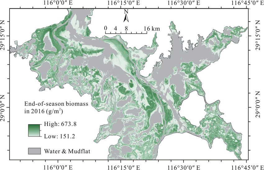
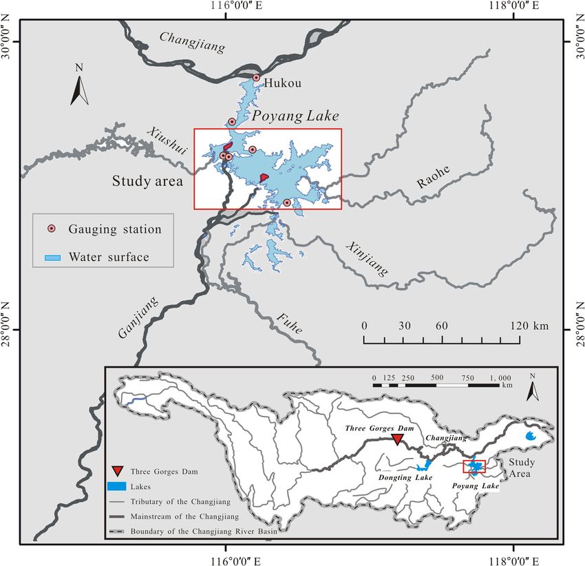
Dai et al.                                                                                                   Vegetation Changes and Flooding Patterns

production is the main carbon input in wetland ecosystems, thus               extent (Dai et al., 2016, 2019). Even though these studies have
serving as a crucial component of carbon sequestration in the                 elucidated the changes of the ecohydrological environment in the
earth’s carbon cycle (Kayranli et al., 2010; Erickson et al., 2013).          Poyang Lake wetland after operation of the Three Gorges Dam,
In seasonally inundated herbaceous wetlands, however, which are               the relationship between biomass production of vegetation and
affected by non-stationary flooding patterns, biomass production              flooding patterns in this wetland area remains largely unclear.
of vegetation usually changes rapidly and shows strong spatial                    This study examined the impacts of changing flooding
heterogeneity (Poff et al., 1997; Dornova, 2012; Byrd et al., 2014;           patterns in Poyang Lake on its biomass production of
Watson and Corona, 2018).                                                     vegetation. Specifically, we used two variables of flooding—that
   Flooding patterns affect vegetation production of wetlands                 is, inundation duration (IDU) and average inundation depth
through multiple aspects, including the timing (e.g., inundation              (IDU)—to describe the flooding pattern of the wetland and
duration) and magnitude (e.g., inundation depth) of flood events              used the end-of-season biomass quantified using NVDI∗ biomass
(Visser et al., 2006; Wantzen et al., 2008; Li et al., 2012). Moreover,       calibrated relationships to describe the vegetation biomass
the impacts of flooding patterns on vegetation productivity are               production of the wetland. Our specific objectives were as
complex. They may stimulate or inhibit vegetation production                  follows: (i) describe and quantify the patterns of vegetation
depending on such factors as the adaptability of plants to                    biomass production across major flooding gradients in the
flood disturbances and other abiotic factors like elevation, slope,           extensive wetland, and (ii) reveal the effects of changing flooding
and reallocation of sediments (Casanova and Brock, 2000;                      conditions on the vegetation biomass production of the wetland
Mokrech et al., 2017). For example, in wetlands experiencing                  since the operation of the Three Gorges Dam.
extreme floods, mechanical damages caused by flooding can
directly reduce plant biomass and can even lead to the
complete disappearance of aboveground parts of plants (Dai                    MATERIALS AND METHODS
et al., 2016; Wan et al., 2018). Vegetation restoration after
extreme flood disturbances often takes several years (Kingsford,              Study Area
2000; Nechwatal et al., 2008). In contrast, the abundant water                Poyang Lake (115◦ 490 E–116◦ 460 E, 28◦ 240 N–29◦ 460 N) (Figure 1)
resources and soil nutrients introduced by floods can optimize                receives discharge from the give upstream rivers (Ganjiang, Fuhe,
the growth conditions of vegetation, thus promoting increased                 Xinjiang, Raohe, and Xiushui) and flows into the Changjiang
productivity for some sites (Burke et al., 1999, 2003; Clawson                River from the lake mouth (Hukou). Influenced by the inflow of
et al., 2001). Trade-offs in site specific impacts from flooding              the five upstream rivers and the block effect of the Changjiang
are difficult to quantify at the landscape scale, yet the net                 River on its outflow, the summer flood generally lasts a prolonged
balance of consequences is important for continued management                 period from June to September (Hu et al., 2007; Zhang et al.,
of these diverse ecosystems. This is particularly true in large,              2014; Dai et al., 2015). The prolonged summer flood provides an
heterogeneous ecosystems, such as the Poyang Lake wetland,                    inability for the trees to survive in this wetland. Thus, Poyang
China (Sang et al., 2014).                                                    Lake wetland is a typical herbaceous wetland with a relatively
   Poyang Lake is the largest freshwater lake and area of alluvial            high vegetation homogeneity (Wu et al., 2012; Sang et al., 2014).
wetlands in China (You et al., 2017; Wan et al., 2018). The                   Specifically, over 80% of its vegetated area is covered by Carex
extensive and prolonged summer flooding has characterized the                 spp., and the left 20% is mainly covered by Phragmites spp. (You
water regime of the wetland (Liu Y. B. et al., 2013; Zhang et al.,            et al., 2017; Dai et al., 2019). In the flood seasons, almost all
2014). The average water levels of the summer flood season and                floodplains are inundated, and the coverage area of the water
the drier part of the year differ by about 11 m, and the duration             surface reaches more than 3,000 km2 . In the drier part of a
of these two periods in a given year is about 33% and 66%,                    given year (October to April of the following year), the lake stage
respectively (Dai et al., 2015). The vast, seasonally inundated               decreases and eventually recedes largely into channels created
alluvial plain has developed to be the largest freshwater wetland             by its tributaries and shallow depressions. At that point, the
in China, of which the average area is about 3000 km2 (Liu C. L.              water surface covers less than 1,000 km2 (Liu Y. B. et al., 2013;
et al., 2013; Dai et al., 2016). In recent decades, the operation             Wan et al., 2018). The extensive exposed lakebed turns into
of the Three Gorges Dam upstream of the lake’s mouth has                      vegetated habitats, which cover more than two-thirds of the
significantly altered the water regimes of the Poyang Lake, in                lakebed. Because of the flat terrain and fertile sediment, the
particular, in regard to its flooding patterns (Hu et al., 2007;              alluvial plains are highly productive habitats and provide many
Mei et al., 2016). Consequently, many studies have revealed the               ecosystem services, including sediment stabilization, habitat and
significant shift in the expansion and contraction of flooding                biodiversity, water quality purification, and carbon and nutrient
events and their influence on vegetation distribution and the                 sequestration (Liu and Nian, 2012).
habitat of migratory birds (Barzen et al., 2009; Tan et al.,
2015; Xu et al., 2015). For example, our previous studies found               Data and Processing
that the premature surface exposure time in the Poyang Lake                   End-of-Season Biomass Mapping in the Poyang Lake
wetland after the Three Gorges Dam dramatically stimulated                    Wetland in 2016
the expansion of vegetation (Dai, 2018; Wan et al., 2018). It                 In this study, we mapped the end-of-season biomass of the
is mainly because that the earlier recession of summer floods                 Poyang Lake wetland in 2016 using a model of NDVI and end-
prolonged the vegetation growth period in autumn to a certain                 of-season biomass developed based on the regression analysis

Frontiers in Plant Science | www.frontiersin.org                          2                                   October 2020 | Volume 11 | Article 521358
Dai et al.                                                                                                         Vegetation Changes and Flooding Patterns

  FIGURE 1 | Map of the Poyang Lake wetland with insert showing its location south of the Changjiang River.

between the field-observed biomass records and the remotely                          between the field measured end-of-season biomass and its
sensed Normalized Difference Vegetation Index (NDVI). The                            corresponding NDVI values. The ordinary least squares
spatial resolution of the NDVI data is 30 m × 30 m, which was                        method estimated the model parameters and the Akaike
calculated from the Landsat OLI image acquired on December                           Information Criterion (AIC) measure the relative quality of
16, 2016 (ID: LC08L1TP12104020161216) by the NDVI tool                               those models. After comparison, we utilized the quadratic
in ENVI 5.1. The field data was gathered during November                             polynomial regression model y = 5369.00x2 – 938.80x + 191.40
24th to December 3rd 2016 at 86 sites from four sub-regions                          (n = 85, R2 = 0.81, AIC = 968.48) to estimate the end-of-season
of the Poyang Lake wetland (Figure 2A). At each sub-region,                          biomass of the wetland. Because the quadratic polynomial
field samplings were conducted perpendicular to the shoreline to                     regression model has a superior performance to the other three
cover different levels of the flooding pattern gradient, and were                    regression models (Figure 2B).
conducted parallel to the shoreline to collect more samples. At
each site, aboveground biomass in a 1 × 1 m plot was harvested                       Flooding Pattern Variables Mapping
by clipping the plants at soil level. Wet biomass was weighed                        We used two variables of flooding—annual average inundation
and then converted to dry biomass through a proportionality                          depth (AID) and inundation duration (IDU)—to characterize
constant, i.e., the water content factor (taken as 0.3 via sample                    the energy and timing of floods in this wetland. We mapped
analysis) (Dai, 2018). The geographic coordinates of those sites                     two flooding pattern variables of each year during the time
were recorded by a GPS (GPS 60, GARMIN), which were then                             period from 1980 to 2016 using the long-term daily water
used to extract the corresponding NDVI from the coincident                           levels of six dispersed gauging stations (Figure 1) and a
Landsat NDVI image.                                                                  digital elevation model (DEM, with a 5 m × 5 m spatial
    We tested four regression models, including a power                              resolution) of the Poyang Lake wetland. Both the hydrologic
law model, an exponential model, a linear regression                                 data and the DEM were provided by the Jiangxi Provincial
model, and a polynomial model to fit the relationship                                Hydrological Bureau, China.

Frontiers in Plant Science | www.frontiersin.org                                 3                                 October 2020 | Volume 11 | Article 521358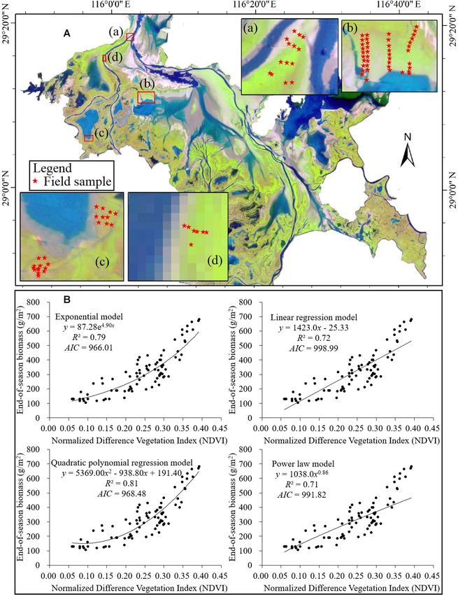
Dai et al.                                                                                                                   Vegetation Changes and Flooding Patterns

  FIGURE 2 | (A) Locations of field sampling sites (the background image is a false color composition of the Landsat OLI image with the band 5, band 4, and band 3
  to red, green, and blue, respectively) and (B) models established for the relationship of NDVI (x) and end-of-season biomass (y) in the Poyang Lake wetland in 2016.

   For the flooding pattern variable mapping, we first generated                       the results by dividing the total length of each year. Thus, the IDU
the daily water surface elevation series of the wetland in each                        ranged from 0 to 1, with a unit of percentage of the year (%). High
year by averaging the daily water levels of the six gauging stations                   IDU values indicated long inundation duration, and vice visa.
and rasterizing them to the whole wetland in the same resolution
with the end-of-season biomass map (30 m × 30 m). Then, we                             Model the Relationships of End-of-Season Biomass
resampled the DEM of the wetland to the same resolution with                           and Flooding Pattern Variables
the water-surface elevation maps. For each pixel, by comparing                         In this study, we modeled the relationship between the end-of-
the elevation of water surface and land surface, we identified                         season biomass and each flooding pattern variable according to
whether it was inundated and how deeply it was inundated on                            the Gaussian mixture model (GMM). Specifically, by matching
each day. Finally, we calculated the AID as the average inundation                     the maps of end-of-season biomass and the two variables of the
depth in a year with a unit of meter (m); we counted IDU as the                        flooding patterns pixel by pixel, we obtained the averaged end-
total number of submerged days in a year and then standardized                         of-season biomass within each gradient of the flooding pattern

Frontiers in Plant Science | www.frontiersin.org                                   4                                         October 2020 | Volume 11 | Article 521358
Dai et al. Vegetation Changes and Flooding Patterns
variable. We set the gradient intervals for AID and IDU to RESULTS
0.1 m and 0.10 (10%), respectively. Then we used GMM to
fit the distribution pattern of the end-of-season biomass along End-of-Season Biomass of Poyang Lake
the flooding pattern gradient. We applied the GMM model in
Wetland in 2016
this study because it is flexible enough to fit both the typical
The end-of-season biomass of Poyang Lake wetland in 2016
hump-shaped curves between variables and the monotonic or
is shown in Figure 3. The mean end-of-season biomass
sigmoidal curves between variables within restricted ranges of
of the wetland was 234.0 g/m2 and the standard deviation
either axis (Gomez-Aparicio et al., 2011; Ruiz-Benito et al., 2014).
was 99.9 g/m2 . The end-of-season biomass varied in a wide
The general function of GMM can be expressed as follows:
range (151.2–673.8 g/m2 ) and showed a clear spatial pattern.
Xn
1 (x − µi )2
Specifically, low end-of-season biomass values occurred in the
∗
y= ci exp − depressions and regions near to the main lake water surfaces; high
2 ti2
i=1 end-of-season biomass values occurred in the moderate elevation
where y is the end-of-season biomass; x is the specific flooding part of the wetland; and moderate end-of-season biomass values
pattern variable (i.e., AID and IDU); and n is the number of occurred in the ridges of the wetland.
peaks of GMM model to fit, where 1 < n < 2 in this study. For
each peak, ci is the maximum of end-of-season biomass, µi is Flooding Pattern of the Poyang Lake
the optimum AID or IDU condition for end-of-season biomass, Wetland in 2016
which appears when y equals ci ; and ti is related to the peak width, The AID and IDU maps of the Poyang Lake wetland in 2016 are
which reveals the most conducive range of each flooding variable shown in Figures 4A,B, respectively. As shown in Figure 4A, the
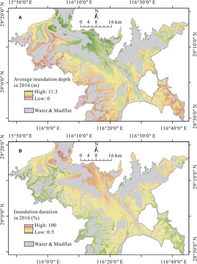
for vegetation production. AID of the wetland ranged from 0.1 to 11.3 m in 2016, with a
mean of 4.2 m and a standard deviation of 1.7 m. Most AIDs of
Extract the Impacts of Changing Flooding Patterns the vegetated area in the wetland were less than 6.0 m. Moreover,
on End-of-Season Biomass After the Three Gorges the AID values varied along the distance to the water surface:
Dam AIDs exhibited larger values surrounding the deep flow channels
To achieve this objective, we first mapped the multi-year and permanently flooded sublakes, whereas they exhibited lower
average AID and IDU of the wetland in two time periods: values in regions near the wetland margins, such as the lake levees
1980–2002 (pre-Three Gorges Dam) and 2003–2016 (post-Three and river banks. Figure 4B shows that the vegetated area of the
Gorges Dam). We characterized the variation of each variable wetland was inundated, on average, for 46% of the days in 2016.
in these two periods according to its differences in gradient The specific IDUs of different sites ranged from 1% to 80%, with
interval average values. Then, we input these values into the a standard deviation of 16%. Similar to AID, IDU of the wetland
obtained GMM models of end-of-season biomass to predict also showed a clear spatial pattern across the wetland. Specifically,
the corresponding vegetation biomass changes triggered by the the near-shore area experienced a longer inundation, whereas the
variations in the flooding pattern variable. offshore area experienced a shorter inundation.
FIGURE 3 | End-of-season biomass of Poyang Lake wetland in 2016.
Frontiers in Plant Science | www.frontiersin.org 5 October 2020 | Volume 11 | Article 521358
Dai et al. Vegetation Changes and Flooding Patterns
FIGURE 4 | (A) Average inundation depth and (B) inundation duration of the Poyang Lake wetland in 2016.
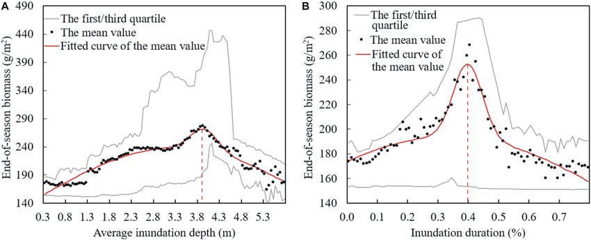
Distribution of End-of-Season Biomass distributions of end-of-season biomass along both the IDU and
Along the Gradients of Flooding Pattern AID gradients were hump-shaped. Specifically, for AID, the
most productive sites in the wetland were in the condition
Variables of an AID equal to 4.0 m (3.9 m, 4.0 m), of which the
The values of end-of-season biomass in different AID and IDU averaged end-of-season biomass peaked at about 271.0 g/m2
intervals are averaged and plotted as black dots in Figure 5, (271.2 g/m2 , 269.4 g/m2 ). For IDU, the most productive sites
along with their GMM fitting curves (the red lines). Moreover, would have 40% (39%, 41%) of the days inundated during the
we also plotted the first and third quartiles of the end-of- whole year. Plants experiencing the most optimal IDU condition
season biomass values within the same inundation variable weighed about 252.8 g/m2 (251.2 g/m2 , 251.8 g/m2 ) at the
intervals in Figure 5 (the gray lines), which show the overall end of season on average. The values of end-of-season biomass
distribution of the data. Table 1 summarizes the parameters of in sites with lower AID values (Dai et al. Vegetation Changes and Flooding Patterns
FIGURE 5 | Distributions of end-of-season biomass along the gradients of (A) average inundation depth and (B) inundation duration in Poyang Lake wetland.
AID values (>4.0 m; IDU > 40%) were negatively correlated inundation duration) during 2003–2016 contributed to lower
with the AID (IDU). end-of-season biomass. Moreover, because the coverage area of
sites converting from deep and long inundation (AID > 3.5 m;
Changes in Flooding Patterns and Their IDU > 54%) to be more productive far exceeded the coverage
Additional Impacts on Vegetation area of sites converting from shallow and short inundation
(AID < 1.6 m; IDU < 24%) to be less productive, the increase of
Production end-of-season biomass in the wetland far exceeded the decrease
The multi-year average AIDs for 1980–2002 and 2003–2016
of that since 2003 (Figures 6A,B). Hence, although a mixed
were 3.2 m and 2.7 m, respectively (Figure 6A). The multi-
changing pattern existed for the end-of-season biomass variations
year average IDUs for 1980–2002 and 2003–2016 were 70.5%
across the wetland (Figure 6B), on average, the end-of-season
and 60.0%, respectively (Figure 6B). Apparently, compared with
biomass for the whole wetland increased by 2.4 g/m2 stimulated
1980–2002, the distributions of both AID and IDU dramatically
by the shift of AID since 2003, with an increased rate of about
shifted to skew toward the right during 2003–2016. That is, for
1.0%. According to the prediction of the end-of-season biomass
most sites in the wetland, the AID and IDU values tended to
model predicted by IDU, the average end-of-season biomass of
become lower. Given the Gaussian form response of end-of-
the wetland also showed an increasing trend since 2003 but with
season biomass to flooding pattern variables, the influence of
a much larger magnitude. That is, the end-of-season biomass
alleviated AID (IDU) on end-of-season biomass varied across the
increased by 15.7 g/m2 on average stimulated by the shift of IDU
extensive wetland (Figures 6C,D). Specifically, for sites in which
since 2003, with an increased rate of about 6.7%.
the values of end-of-season biomass were negatively correlated
with the AID (IDU)—that is, sites with higher AIDs (IDUs)—
shallower inundation depth (shorter inundation duration) in
2003–2016 contributed to higher end-of-season biomass. On the
DISCUSSION
contrary, for sites in which the values of end-of-season biomass In our previous research, we discussed the response of vegetation
were positively correlated with the AID (IDU)—that is, sites biomass to land surface exposure time after flooding in the
with lower AIDs (IDUs)—shallower inundation depth (shorter Poyang Lake wetland to reveal the influence of Three Gorges
Dam on biomass production (Dai, 2018). After the operation
TABLE 1 | Parameters of end-of-season biomass models fitted by GMM function of the Three Gorges Dam, the land surface of the wetland
via the flooding pattern variable AID and IDU. has been exposed prematurely. The land surface premature
AID and end-of-season IDU and end-of-season
triggered by the Three Gorges Dam has been considered to have
biomass model biomass model the most dramatic influence on vegetation because the main
wetland vegetation sedges begin to re-grow exactly as the summer
c1 238.10 193.70
flooding in this wetland ends (Mei et al., 2016; Wan et al., 2018).
µ1 3.31 0.34
In this study, however, we found that the summer flood
t1 4.58 1.02
patterns also played an important role in vegetation production
c2 37.55 59.87
in the wetland, even though sedges generally were dormant
µ2 3.95 0.40
during the summer floods. Specifically, our results revealed that
t2 0.43 0.07
with shifts in flooding duration and inundation depth after
R2 0.92 0.91
the operation of the Three Gorges Dam that biomass has on
Frontiers in Plant Science | www.frontiersin.org 7 October 2020 | Volume 11 | Article 521358Dai et al. Vegetation Changes and Flooding Patterns
FIGURE 6 | Changes in flooding patterns of Poyang Lake wetland between 1980–2002 and 2003–2016 (A for AID and B for IDU) and their additional impacts on
end-of-season biomass of the wetland (C for AID and D for IDU).
average for the full area increased. Moreover, similar Gaussian aboveground shoots wither and the plants go dormant. Plants at
distribution patterns of the end-of-season biomass have been higher surfaces still stand above the water surface and continue
found for both AID and IDU gradients in this wetland, as well to grow (Zhang et al., 2013; Tan et al., 2015). During the autumn,
as the hydrologic variable-stimulated biomass production since the water level recedes and plants at the lower surfaces initiate
the operation of the Three Gorges Dam. In previous studies, the growth as the sites are eventually exposed. The plants in the
intermediate disturbance hypothesis has been applied and tested higher surfaces turn to a senesce period in autumn (Wan et al.,
in larger systems for the diversity pattern of vegetation, which 2018; Dai et al., 2019). Note that the main water stresses for
believes that the diversity will likely be higher at intermediate plants in higher and lower surfaces are different. Plants in the
sites because of the unidirectional variations in the disturbance higher surfaces usually have to withstand water stresses caused by
(Osman, 2015). In this study, we found a biomass pattern extended dry phases, whereas plants in the lower surfaces usually
consistent with the intermediate disturbance hypothesis but have to face water stresses caused by extended floods. Thus, the
not resulting from a gradient in species disturbance. Actually, Gaussian form effects of both AID and IDU to end-of-season
we found that gradients in flooding pattern variables such as biomass across the wetland can be explained by different water
inundation depth and inundation duration lead to the different stresses faced by plants at different elevations.
biomass production at the extremes based on species tolerances. Average inundation depth is an energy variable of flooding
Our findings suggest that gradients of biomass or diversity can patterns. This value measures the relative energy magnitude of
result not only from unidirectional variations in disturbance but a flooding process assigned to different sites on the basis of
from variations in one or more environmental variables. elevation. For plants at lower surfaces, deep AID accompanied by
Flooding patterns in the vegetation production of the wetland high oxygen deficiency, high light deficiency, heavy mechanical
mainly affect the flooding-oriented life cycle of vegetation in damage, and other flooding stresses on physical parameters
the wetland (Lei et al., 2011; Wu et al., 2012; Zhang et al., limits the production of vegetation. Thus, end-of-season biomass
2012). Therefore, before analyzing the effects of flooding pattern is negatively related to AID for sites with extremely deep
variables on vegetation production, we first clarified the life cycle inundation depth. In contrast, for plants in the higher surfaces,
of plants in the wetland. In the spring, plants in both lower and deep AID generally means good water availability and weakening
higher surfaces of the wetland begin to grow promoted by an drought stresses in their growth period. Thus, end-of-season
increase in soil moisture and absent submersion with an increase biomass is positively related to AID for sites with extremely
in the lake-water level (Sang et al., 2014; Dai et al., 2016). During shallow inundation depth. Additionally, the differing hydrology
the summer flood season, the rising water level spreads over the to geomorphology processes in the lower and higher surfaces
lower surfaces and eventually completely covers the plants; thus, aggravates the response differences of end-of-season biomass
Frontiers in Plant Science | www.frontiersin.org 8 October 2020 | Volume 11 | Article 521358Dai et al. Vegetation Changes and Flooding Patterns
to AID in different elevation zones. Specifically, erosion is drought stresses as the AID and IDU values decreased since
the main hydro-geomorphology process in the lower surfaces 2003. The end-of-season biomass increased in lower surfaces
(Lu et al., 2011; Wang et al., 2014). As a result, the soil at because of the relief of flooding stresses as the AID and
these elevations become more barren with a deeper AID, thus IDU values decreased. This conclusion is consistent with the
exacerbating the negative feedback of end-of-season biomass to results we obtained from the vegetation biomass study that
AID in the lower surfaces. In contrast, deposition is the main examined land surface exposure time after flooding in the
hydro-geomorphology process in the higher surfaces. As a result, wetland (Dai, 2018). Importantly, different flooding variables,
the deeper AID at these elevations indicates greater sedimentary including AID and IDU, triggered different magnitudes of
nutrient accumulation, which exacerbates the positive feedback end-of-season biomass variation. The end-of-season biomass
of end-of-season biomass to AID in the higher surfaces. Similar increase predicted by IDU was larger than that predicted by
conclusions about the impact of flooding depth on community AID. We think this phenomenon can be attributed primarily
biomass have been confirmed by several studies (Seabloom et al., to the higher adaptability of wetland vegetation to AID than its
1998; Wassen et al., 2002). For example, Lou et al. (2016) adaptability to IDU. For example, the study by Hu et al. (2018)
accessed the impact of flooding depth on wetland vegetation in the Dongting Lake wetland revealed that the distribution
between different vegetation types and found that the biomass elevations of wetland vegetation varied to some extent in different
of Carex lasiocarpa residing at a higher elevation showed an years, although their annual inundation duration was relatively
increasing trend with increasing water-table depth, whereas constant. It also indicated that IDU may be a better indicator to
Carex angustifolia residing at a lower elevation displayed a predict changes in vegetation production in response to wetland
negative correlation between biomass and water-table depth. flooding patterns.
The Gaussian form response of end-of-season biomass also In summary, this study explained the influence of flooding
applied to the flooding pattern variable IDU. IDU is a timing pattern variables on end-of-season biomass of the Poyang Lake
variable of flooding pattern, which is determined by both the wetland from the aspect of water stresses faced by plants residing
start and end date of flooding events. Because both of the at different elevations, thus providing insights into the effect
timing variables have different functions on plants at different of Three Gorges Dam on vegetation production of Poyang
elevations, the effect of IDU on end-of-season biomass also Lake wetland. Moreover, because a significant and continual
varies according to the distribution of plants. Specifically, for alleviation of the flooding pattern after operation of the Three
plants in the lower surfaces, the start time of inundation Gorges Dam is forecasted, a continual high level of vegetation
determines the end time of their first re-growth period before production in the wetland can be expected. Hence, the additional
flooding. In contrast, for plants in the higher surfaces, the impacts on wetland plants-dependent animals, including fish
start time of inundation indicates the time at which they and migratory birds, should be further evaluated to maintain
receive the first irrigation. The end time of flooding events ecosystem stability and structural integrity of this important
determines the regeneration time of plants after flooding in wetland, especially after the operation of the Three Gorges Dam.
the lower surfaces. Conversely, the end time of flooding events
also determines when the plants begin to suffer from drought
stresses for plants in the higher surfaces (Dai et al., 2019). DATA AVAILABILITY STATEMENT
Therefore, IDU determines the length of the growing period
of plants in the lower surfaces, and the water availability of All datasets generated for this study are included in the
plants in the higher surfaces. Hence, end-of-season biomass is article/supplementary material.
negatively correlated to IDU in the lower surfaces with long
IDU and is positively correlated to IDU in higher surfaces with
short IDU. Several results in previous studies have supported
AUTHOR CONTRIBUTIONS
our conclusions. For example, Tan et al. (2015) revealed that XD, GY, and ZY conceived the study idea. XD and RW collected
Carex community residing at an elevation range of 13–15 m the data and conducted the relationship analysis between
and a Phragmites community residing at an elevation range of flooding patterns and end-of-season biomass. GY and ZY
15–17 m had different optimum inundation durations, which discussed and contributed to the final framework of this study.
were 159 days for the Carex community and 144 days for the XD wrote the first draft of the manuscript with significant help
Phragmites community. from GY, ZY, and RW. All authors contributed to manuscript
Since the operation of the Three Gorges Dam, flooding completion and revision.
of the Poyang Lake wetland has been significantly alleviated,
along with the AID and IDU of the floodplain. According
to a comparison of AID (IDU) between the two periods of FUNDING
1980–2002 and 2003–2016, we estimated the variation of end-
of-season biomass pre- and post-Three Gorges Dam through We acknowledge the funding support from the National
the obtained end-of-season biomass models established by Scientific Foundation of China (Grant No. 41901114), the
AID (IDU). The results revealed an unbalanced variation of Fundamental Research Funds for the Central Universities of
end-of-season biomass across the wetland. The end-of-season China (Grant No. B200202024), and the National Postdoctoral
biomass decreased in higher surfaces because of the exacerbated Program for Innovative Talent (Grant No. BX20190107).
Frontiers in Plant Science | www.frontiersin.org 9 October 2020 | Volume 11 | Article 521358Dai et al. Vegetation Changes and Flooding Patterns
REFERENCES Lei, S., Zhang, X.-P., Li, R.-F., Xu, X.-H., and Fu, Q. (2011). Analysis the changes of
annual for Poyang Lake wetland vegetation based on MODIS monitoring. Proc.
Barzen, J., Engels, M., Burnham, J., Harris, J., and Wu, G. (2009). Potential Environ. Sci. 10, 1841–1846. doi: 10.1016/j.proenv.2011.09.288
Impacts of Poyang Lake Projects on the Quantity and Distribution of Wintering Li, F., Qin, X. Y., Xie, Y. H., Chen, X. S., Hu, J. Y., Liu, Y. Y., et al. (2012).
Waterbirds. Baraboo, WI: International Crane Foundation. Physiological mechanisms for plant distribution pattern: responses to flooding
Burke, M. K., King, S. L., Gartner, D., and Eisenbies, M. H. (2003). Vegetation, and drought in three wetland plants from Dongting Lake, China. Limnology 14,
soil, and flooding relationships in a blackwater floodplain forest. Wetlands 23, 71–76. doi: 10.1007/s10201-012-0386-4
988–1002. doi: 10.1672/0277-5212(2003)023[0988:vsafri]2.0.co;2 Liu, C. L., Liu, X. S., and Liao, Q. M. (2013). Poyang lake wetland information
Burke, M. K., Lockaby, B. G., and Conner, W. H. (1999). Aboveground production extraction and change monitoring based on spatial data mining. Inform.
and nutrient circulation along a flooding gradient in a South Carolina Coastal Technol. J. 12, 6143–6148. doi: 10.3923/itj.2013.6143.6148
Plain forest. Can. J. For. Res. 29, 1402–1418. doi: 10.1139/x99-111 Liu, Q., and Nian, B. Y. (2012). Theory and Practice of Ecological Restoration for
Byrd, K. B., O’Connell, J. L., Tommaso, S. D., and Kelly, M. (2014). Evaluation of Poyang Lake Wetland. Beijing: Science Press.
sensor types and environmental controls on mapping biomass of coastal marsh Liu, Y. B., Wu, G. P., and Zhao, X. S. (2013). Recent declines in China’s largest
emergent vegetation. Remote Sens. Environ. 149, 166–180. doi: 10.1016/j.rse. freshwater lake: trend or regime shift? Environ. Res. Lett. 8:014010. doi: 10.1088/
2014.04.003 1748-9326/8/1/014010
Casanova, M. T., and Brock, M. A. (2000). How do depth, duration and frequency Lou, Y. J., Pan, Y. W., Gao, C. Y., Jiang, M., Lu, X. G., and Xu, Y. J. (2016).
of flooding influence the establishment of wetland plant communities? Plant Response of plant height, species richness and aboveground biomass to flooding
Ecol. 147, 237–250. doi: 10.1023/A:1009875226637 gradient along vegetation zones in floodplain wetlands, Northeast China. PLoS
Clawson, R. G., Lockaby, B. G., and Rummer, B. (2001). Changes in production and One 11:e0153972. doi: 10.1371/journal.pone.0153972
nutrient cycling across a wetness gradient within a floodplain forest. Ecosystems Lu, J. Z., Chen, X. L., Li, H., Liu, H., Xiao, J. J., and Yin, J. M. (2011).
4, 126–138. doi: 10.1007/s100210000063 Soil erosion changes based on GIS/RS and USLE in Poyang Lake basin.
Dai, X. (2018). Effects of Hydrological Conditions on Vegetation Carbon Trans. Chin. Soc. Agric. Eng. 27, 337–344. doi: 10.3969/j.issn.1002-6819.2011.
Sequestration of Poyang Lake Wetland. Ph. D thesis, University of Chinese 02.057
Academy of Sciences, Nanjing, JS. Mei, X. F., Dai, Z. J., Du, J. Z., and Chen, J. Y. (2016). Linkage between Three
Dai, X., Wan, R. R., and Yang, G. S. (2015). Non-stationary water-level fluctuation Gorges Dam impacts and the dramatic recessions in China’s largest freshwater
in China’s Poyang Lake and its interactions with Yangtze River. J. Geogr. Sci. 25, lake, Poyang Lake. Sci. Rep. 5:18197. doi: 10.1038/srep18197
274–288. doi: 10.1007/s11442-015-1167-x Mokrech, M., Kebede, A. S., and Nicholls, R. J. (2017). Assessing Flood Impacts,
Dai, X., Wan, R. R., Yang, G. S., Wang, X. L., and Xu, L. G. (2016). Responses Wetland Changes and Climate Adaptation in Europe: the CLIMSAVE Approach//
of wetland vegetation in Poyang Lake, China to water-level fluctuation. Environmental Modeling with Stakeholders. Berlin: Springer International
Hydrobiologia 773, 35–37. doi: 10.1007/s10750-016-2677-y Publishing.
Dai, X., Wan, R. R., Yang, G. S., Wang, X. L., Xu, L. G., Li, Y. Y., et al. (2019). Impact Nechwatal, J., Wielgoss, A., and Mendgen, K. (2008). Flooding events and rising
of seasonal water-level fluctuations on autumn vegetation in Poyang Lake water temperatures increase the significance of the reed pathogen Pythium
wetland, China. Front. Earth Sci. 13, 398–409. doi: 10.1007/s11707-018-0731-y phragmitis as a contributing factor in the decline of Phragmites australis.
Dornova, I. (2012). The Study of Seasonal Composition and Dynamics of Wetland Hydrobiologia 613, 109–115. doi: 10.1007/s10750-008-9476-z
Ecosystems and Wintering Bird Habitat at Poyang Lake, PR China Using Object- Osman, R. W. (2015). The intermediate disturbance hypothesis. Encycl. Ecol. 12,
Based Image Analysis and Field Observations. Berkeley: University of California. 441–450. doi: 10.1016/b978-0-12-409548-9.09480-x
Erickson, J. E., Peresta, G., Montovan, K. J., and Drake, B. G. (2013). Direct and Paillisson, J. M., Reeber, S., Carpentier, A., and Marion, L. (2006). Plant-water
indirect effects of elevated atmospheric CO2 on net ecosystem production in a regime management in a wetland: consequences for a floating vegetation-
Chesapeake Bay tidal wetland. Glob. Chang. Biol. 19, 3368–3378. doi: 10.1111/ nesting bird, whiskered tern Chlidonias hybridus. Biodiver. Conserv. 15, 3469–
gcb.12316 3480. doi: 10.1007/s10531-004-2939-2
Fisher, S. J., and Willis, D. W. (2000). Seasonal dynamics of aquatic fauna and Poff, N. L., Allan, J. D., Bain, M. B., Karr, J. R., Prestegaard, K. L., Richter, B. D., et al.
habitat parameters in a perched upper Missouri River wetland. Wetlands 20, (1997). The natural flow regime. Bioscience 47, 769–784. doi: 10.2307/1313099
470–478. doi: 10.1672/0277-5212(2000)0202.0.co;2 Ruiz-Benito, P., Gomez-Aparicio, L., Paquette, A., Messier, C., Kattge, J., and
Gathman, J. P., and Burton, T. M. (2011). A great lakes coastal wetland invertebrate Zavala, M. A. (2014). Diversity increases carbon storage and tree productivity
community gradient: relative influence of flooding regime and vegetation in Spanish forests. Glob. Ecol. Biogeogr. 23, 311–322. doi: 10.1111/geb.12126
zonation. Wetlands 31, 329–341. doi: 10.1007/s13157-010-0140-9 Sang, H. Y., Zhang, J. X., Lin, H., and Zhai, L. (2014). Multi-Polarization ASAR
Gomez-Aparicio, L., Garcıa-Valdes, R., Ruiz-Benito, P., and Zavala, M. A. (2011). Backscattering from Herbaceous Wetlands in Poyang Lake Region, China. Rem.
Disentangling the relative importance of climate, size and competition on tree Sens. 6, 4621–4646. doi: 10.3390/rs6054621
growth in Iberian forests: implications for management under global change. Seabloom, E. W., van der Valk, A. G., and Moloney, K. A. (1998). The role of
Glob. Chang. Biol. 17, 2400–2414. doi: 10.1111/j.1365-2486.2011.02421.x water depth and soil temperature in determining initial composition of prairie
Hu, J., Xie, Y., Tang, Y., Li, F., and Zou, Y. (2018). Changes of vegetation wetland coenoclines. Plant Ecol. 138, 203–216. doi: 10.1023/A:1009711919757
distribution in the East Dongting Lake after the operation of the Three Gorges Tan, Z. Q., Tao, H., Jiang, J. H., and Zhang, Q. (2015). Influences of Climate
Dam, China. Front. Plant Sci. 9:582. doi: 10.3389/fpls.2018.00582 extremes on NDVI (Normalized difference vegetation index) in the Poyang
Hu, Q., Feng, S., Guo, H., Chen, G. Y., and Jiang, T. (2007). Interactions of Lake Basin, China. Wetlands 35, 1033–1042. doi: 10.1007/s13157-015-0692-9
the Yangtze river flow and hydrologic processes of the Poyang Lake, China. Tockner, K., and Stanford, J. A. (2002). Riverine flood plains: present state and
J. Hydrol. 347, 90–100. doi: 10.1016/j.jhydrol.2007.09.005 future trends. Environ. Conserv. 29, 308–330. doi: 10.1017/S037689290200022x
Jia, Y. F., Zhang, Y. M., Lei, J. L., Jiao, S. W., Lei, G. C., Yu, G. H., et al. (2017). Visser, J. M., Sasser, C. E., and Cade, B. S. (2006). The effect of multiple stressors
Activity patterns of four cranes in Poyang Lake, China: indication of habitat on salt marsh end-of-season biomass. Estuar. Coasts 29:328. doi: 10.1007/
naturalness. Wetlands 7, 1–9. doi: 10.1007/s13157-017-0911-7 BF02782001
Kayranli, B., Scholz, M., Mustafa, A., and Hedmark, A. (2010). Carbon storage Wan, R. R., Dai, X., and Shankman, D. (2018). Vegetation response to hydrological
and fluxes within freshwater wetlands: a critical review. Wetlands 30, 111–124. changes in Poyang Lake, China. Wetlands 39, 99–112. doi: 10.1007/s13157-018-
doi: 10.1007/s13157-009-0003-4 1046-1
Kingsford, R. T. (2000). Ecological impacts of dams, water diversions and river Wang, X. L., Han, J. Y., Xu, L. G., Wan, R. R., and Chen, Y. W. (2014). Soil
management on floodplain wetlands in Australia. Austral. Ecol. 25, 109–127. characteristics in relation to vegetation communities in the wetlands of Poyang
doi: 10.1046/j.1442-9993.2000.01036.x Lake, China. Wetlands 34, 829–839. doi: 10.1007/s13157-014-0546-x
Kingsford, R. T., and Thomas, R. F. (2004). Destruction of wetlands and waterbird Wantzen, K. M., Junk, W. J., and Rothhaupt, K. O. (2008). An extension of the
populations by dams and irrigation on the Murrumbidgee River in Arid floodpulse concept (FPC) for lakes. Hydrobiologia 613, 151–170. doi: 10.1007/
Australia. Environ. Manag. 34, 383–396. doi: 10.1007/s00267-004-0250-3 s10750-008-9480-3
Frontiers in Plant Science | www.frontiersin.org 10 October 2020 | Volume 11 | Article 521358Dai et al. Vegetation Changes and Flooding Patterns Watson, E. B., and Corona, A. H. (2018). Assessment of blue carbon storage by Baja Zhang, L. L., Yin, J. X., Jiang, Y. Z., and Wang, H. (2012). Relationship between the California (Mexico) tidal wetlands and evidence for wetland stability in the face hydrological conditions and the distribution of vegetation communities within of anthropogenic and climatic impacts. Sensors 18:32. doi: 10.3390/s18010032 the Poyang Lake National Nature Reserve, China. Ecol. Inform. 11, 65–75. Wassen, M. J., Peeters, W. H. M., and Venterink, H. O. (2002). Patterns doi: 10.1016/j.ecoinf.2012.05.006 in vegetation, hydrology, and nutrient availability in an undisturbed river Zhang, M., Ni, L. Y., Xu, J., He, L., Fu, H., and Liu, Z. G. (2013). Annual dynamics floodplain in Poland. Plant Ecol. 165, 27–43. doi: 10.1023/A:102149332 of the wetland plants community in Poyang Lake in response to water-level 7180 variations. Res. Environ. Sci. 26, 1057–1063. Wu, Q., Yao, B., Zhu, L. L., Xing, R. X., and Hu, Q. W. (2012). Seasonal variation Zhang, Q., Ye, X., Werner, A. D., Li, Y. L., Yao, J., Li, X. H., et al. (2014). An in plant biomass of Carex cinerascens and its carbon fixation assessment investigation of enhanced recessions in Poyang Lake: comparison of Yangtze in a typical Poyang Lake marshland. Resourc. Environ. Yangtze Basin 21, River and local catchment impacts. J. Hydrol. 517, 425–434. doi: 10.1016/j. 215–219. jhydrol.2014.05.051 Xie, Y. H., Yue, T., Chen, X. S., Feng, L., and Deng, Z. M. (2015). The impact of three Gorges Dam on the downstream eco-hydrological environment and Conflict of Interest: The authors declare that the research was conducted in the vegetation distribution of East Dongting Lake. Ecohydrology 8, 738–746. doi: absence of any commercial or financial relationships that could be construed as a 10.1002/eco.1543 potential conflict of interest. Xu, X. L., Zhang, Q., Tan, Z. Q., Li, Y. L., and Wang, X. L. (2015). Effects of water- table depth and soil moisture on plant biomass, diversity, and distribution at Copyright © 2020 Dai, Yu, Yang and Wan. This is an open-access article distributed a seasonally flooded wetland of Poyang Lake. Chin. Geogr. Sci. 25, 739–756. under the terms of the Creative Commons Attribution License (CC BY). The use, doi: 10.1007/s11769-11015-10000-11760 distribution or reproduction in other forums is permitted, provided the original You, H. L., Fan, H. X., Xu, L. G., Wu, Y. M., Wang, X. L., Liu, L. Z., et al. (2017). author(s) and the copyright owner(s) are credited and that the original publication Effects of water regime on spring wetland landscape evolution in Poyang Lake in this journal is cited, in accordance with accepted academic practice. No use, between 2000 and 2010. Water 9:467. doi: 10.3390/w9070467 distribution or reproduction is permitted which does not comply with these terms. Frontiers in Plant Science | www.frontiersin.org 11 October 2020 | Volume 11 | Article 521358
You can also read