Rose Park Neighborhood Council - Leadership Team Meeting Minutes
←
→
Page content transcription
If your browser does not render page correctly, please read the page content below
Rose Park Neighborhood Council – Leadership Team Meeting Minutes

April 24th, 2019 (Wednesday) – 5:00 pm – Missoula Senior Center (705 S. Higgins)

Leadership Team Members in Attendance: Roula Agne, Julie Devlin, Tate Jones, Katie LaPointe,
Elizabeth Williams, Michael Painter.

Others in Attendance: Karen Gasvoda (Office of Neighborhoods), Casey Erickson (Rose Park NC),
Jeff Miller (Lewis & Clark NC), Jeff Lamson (Lewis & Clark NCLT), Andie Conlon (National Wildlife
Federation), Penelope LaPointe (Rose Park NC / RPNC LT Morale Officer)

Co-Chair Katie LaPointe called the meeting to order at 5:00 p.m. Introductions & welcome.

Traffic Statistics Analysis – Lewis & Clark NC / South Avenue – Jeff Miller, Lewis & Clark NC
resident, gave a report on his analysis & study of available traffic statistics (traffic counts, accident
information, and traffic control / safety devices in place) in the Lewis & Clark neighborhood,
including boundary streets. Lewis & Clark NC has been in discussion with Ben Weiss regarding
traffic control & traffic safety devices in their neighborhood. Jeff also provided recommendations for
collecting better data in support of neighborhood requests for traffic control or traffic safety devices.
Additional recommendations neighborhoods might consider to help reduce accidents include (1)
increasing police patrol / monitoring, (2) improving driver & pedestrian awareness, and (3)
increasing signage and decreasing speed limits. (Note: Jeff Miller gave a similar presentation at
Lewis & Clark NC’s General Meeting on March 6th – slides from Jeff’s presentation may be available
on the City’s website.)

Meeting Minutes – Minutes from the January 23, 2019 Rose Park Neighborhood Council Leadership
Team meeting were approved.

National Wildlife Federation – Garden for Wildlife – Andie Conlon, currently serving as Education
& Outreach Assistant in the Missoula office of NWF, discussed their ongoing efforts to certify gardens
& parks in our community to help provide wildlife habitat. Andie handed out information regarding the
certification process & noted that NWF will be partnering with Missoula Urban Demonstration (MUD)
on two upcoming Rain Barrel Workshop events – May 18th & June 22nd from 9:00 am to 12:00 pm at
MUD (1527 Wyoming).

Review of Neighborhood Projects

   •   Julie Devlin reported that she believes she has enough funding collected for the Traffic Circle
       project @ Crosby & Cleveland. (Ben Weiss had requested that the funds be in hand by May
       1st in order to get the project started this year.)
   •   Painter briefly discussed recommendations regarding improvements to the Slant Street
       Gateway. Roula asked for descriptions of the neighborhood grants which still have funds
       available to help with the project – she offered to help with a “change of scope” for those
       grants once a plan is approved. Painter asked that the May Rose Park NC Leadership Team
       meeting be held at the Slant Street Gateway (weather permitting) – that was approved by
       voice vote. Painter will notify others who have expressed interest in working on the project and
       invite them to attend as well.
   •   Missoula Parks & Rec has scheduled a Memorial Rose Garden Volunteer Work Day for this
       Saturday – LT members were encouraged to promote that work session and attend if possible.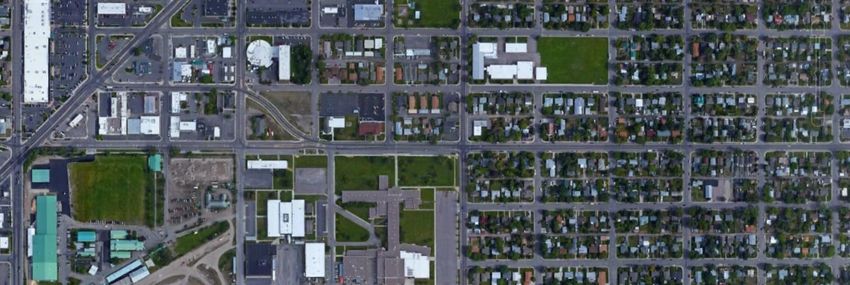
Public Comment – Jeff Lamson, member of the Lewis & Clark NC Leadership Team (but who also
owns property in Rose Park NC) expressed concerns about MCPS students crossing busy Missoula
roadways (S. Russell St.) if the proposed school boundary changes are implemented.

Community Forum Reports – Julie gave a report on the January & February Community Forum
meetings. January presenters included: Shane Stack (MT DOT) & Katie Klietz (Big Sky Public
Relations) gave an update on the Russell Street project, Carol Garlington (Moose Can Gully NC’s
Leadership Team) led a discussion on City-Wide NC priorities. February presenters included: Kaia
Peterson (Franklin School PTA) on the Franklin School Garden & Playground (funded in part by a
neighborhood grant), Tara Osendorf (Development Services) on the Pedestrian Facilities Master
Plan, and Tom Zavitz & Garin Wally (Development Services) on the Urban Fringe Development Area.

Painter reported on March’s Community Forum – presenters included: Bob Hayes (Storm Water
Superintendent) on the Storm Water Facility Utility & Operations Plan, Vince Caristo (Mountain Line)
on Mountain Line Transit’s work in progress.

Office Of Neighborhoods Report – Karen reported on current Office of Neighborhood projects:
     • The Office of Neighborhoods is moving – the new location will be in the building currently
        housing the Office of Housing & Community Development (400 Ryman St.), next door to the
        City Council Chambers.
     • Office of Neighborhoods is holding a Traffic Circle Appreciation event at Bonner Park on
        Tuesday, May 21st – hopefully to sign up neighbors to “adopt” traffic circles in their
        neighborhood which do not at present have volunteer caretakers. (There are 3 such traffic
        circles in Rose Park NC.)

Next Meeting – The next Rose Park Neighborhood Council Leadership Team meeting is tentatively
scheduled for Wednesday, May 22nd, 2019, at 5:00 pm at the Slant Street Gateway. (Directly across
Mount Avenue from Missoula City Fire Department Station #2 @ 247 Mount Ave. This is also the
intersection of Franklin & Plymouth.)

Submitted by Painter April.25.2019
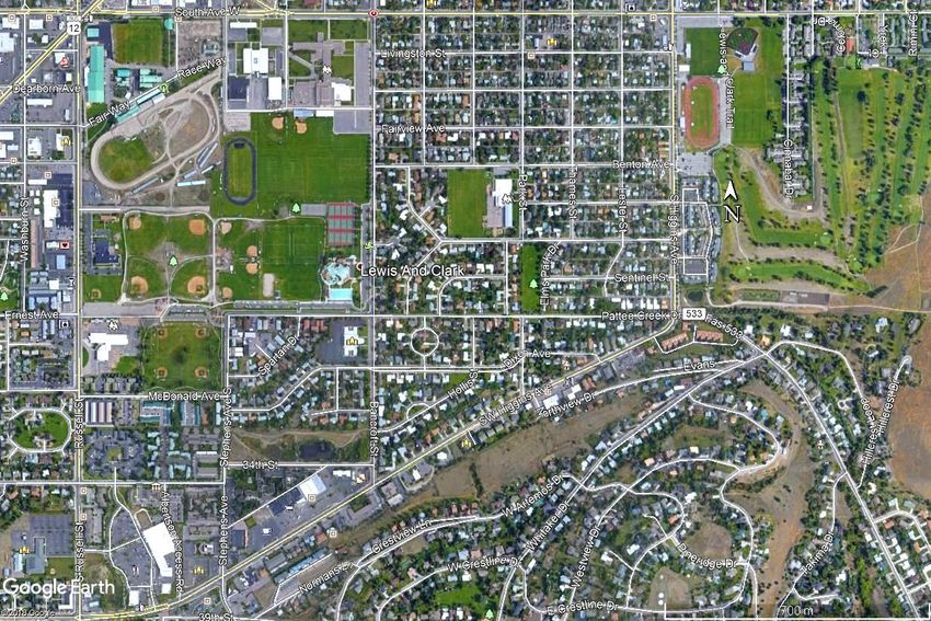
Lewis & Clark Neighborhood

2007-2017 Accident Assessment –

    Methods, Outcomes, &
        Shared Issues
            JD Miller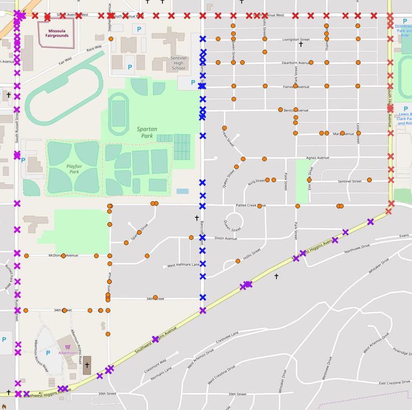
Introduction
• Identifying issues & problems requires
  accurate and precise information & data.

• Focus on Traffic Data [a GIS approach]

• Asking Questions is important.

• Getting answers is essential to decision
  making.
What is GIS?
Computer based mapping of layers of information
                           • Data are shown as
                             points, lines, and
                             polygons.

                           • Multiple & Different
                             layers can be shown

                           • Looks like a paper
                             map
Mapping Data
• GIS [QuantumGIS]
  – bit of a learning curve but very useful and free
• Open Street Map - Base map of streets
  – On-line, free to download and use
• Other sources of data
  – City Accident Reports (Jane Kelly; Ben Weiss) [free]
  – State Traffic Site (Traffic count data) [free]
  – GPS locations for: Crosswalks & Stop Signs, Stop
    Lights, Yield Signs, => all existing features [free]
Limitations of data used to answer
          the questions
• Traffic Crash data are
   – time limited [period 2007 through 2017 or 11 Years].
   – and arranged into various groups/categories.
• Traffic Count data are
  • Numbers on specific streets       and
  • at specific times [day, month, year]

• GPS data [feature at a location]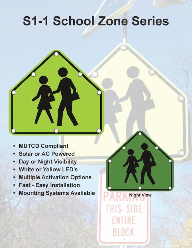
Map of Events provided by City

                                      Boundary Roads 2006-2016
                                          (From Excel file LC-Main)
 Bancroft

              Look at the colors of the dots.
                  Greenish = Inside L&C
                Bluish = Boundary of L&C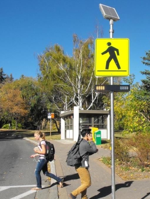
Types of Data available
  Categories of events in City Accident Reports
Crash Record                            ID number
Crash Date                              Date
Crash Occurrence                        Day of Week
Collision                               16 types
Junction Related                        4 types
Weather, Road Surface, Light Conditions 8 types, 5 types, 5 types
Fatalities, Vehicles, Pedestrians       Number (count)
Injuries                                Number (count)
Most Severe                             5 types
Contributing Circumstance a & b         5 types
First Harm                              7 types
First Harm 2                            13 types
Y-Coordinate / X-Coordinate             Montana Grid System
Data Conversions & Analysis
• Latitude / Longitude in decimal degrees derived
      from Montana Grid System (gives points / places)
• Street Name can be identified by plotting points and
      using a street map of Missoula
• Crash_Date was separated by Day, Month, Year for
      analysis
Analysis [in Excel]
• counted within the groups / categories of the data
• used GIS (computer mapping) and graphs to illustrate
  the extracted information
Asking Questions
Does the Lewis & Clark neighborhood have
traffic problems / issues?
• How much traffic occurs in the L&C? [Counts at Places]
• What type of traffic problems/issues occur?
[Summary graphs &/or Maps]
• Where do Accidents Occur? [Mapping Points by Type of
Collision]
• When do Accidents Occur? [Year, Month, Day]
• What are the conditions when accidents occur?
[Weather & Light_Conditions, Road_Surface]
• How severe are the accidents? [First_Harm X First_Ha_2]
• What are the options for solutions?Lewis & Clark Neighborhood
BOUNDARY
Sentinel H S
of L&C (RED)
= South Ave,
Benton
L&C
Higgins,
Bancroft
School
SW Higgins,
Russell, &
Bancroft
LAND USE:
Park Multi Family Residential
Bancroft Ponds
Single Family Residential
High School
Grade School
Parks & Recreation Areas
Fair GroundsHow much traffic occurs in the L&C?
South
3,104 Cars/d South
Sentinel H S
5,352 Cars/d
Park
804 Cars/d Lester
231 Cars/d
Benton
Lewis
Russell 731 Cars/d &
13,384 Cars/d
Clark
School
Higgins
Bancroft 10,878 Cars/d
6,395 Cars/d
Higgins
8,594 Cars/d
Russell
10,513 Cars/d
SW Higgins
11,984 Cars/d
From MT State Traffic CountWhat Type of Accidents Occur?
350 14
L&C L&C
300 12
Boundary Boundary
250 10
200 8
150 6
100 4
50 2
0 0
Data from 2007-2017>60
Where35do Accidents Occur
>30
Sentinel Bancroft = 70
HS
Higgins = 77
Russell St = 325
>40
Lewis South Ave = 97
&
Clark
School
SW Higgins = 113
>14 Sum = 682 (82.5%)
L&C = 145 (17.5%)
>60How severe are the accidents?
600
PERCENT L&C Boundary
L&C Non-Injury Accident
500 (Property-Damage-Only 82.1 72.1
Boundary
400
Accident)
Possible Injury Accident 9.7 17.0
300 Non-Incapacitating
4.8 5.3
Evident Injury Accident
200
Incapacitating Injury
1.4 4.5
100 Accident
Fatal Accident 0.0 0.1
0
Unknown 2.1 0.9
Data from 2007-2017Most Important Accidents
20
18
L&C
16 Boundary PERCENT L&C Boundary
14
Bicycles 9.5 90.5
12
10 Pedestrians 13.3 86.7
8 Pedestrian Fatality 0.0 100
6
4
2
0
Bicycles Pedestrians Pedestrian
Fatality
Data from 2007-2017Stoplights, Stop Signs & Crosswalks
Sentinel H S Stoplights
Stoplights= 4
Flashing Stop= 1
Lewis
&
Clark
School
Stop Signs
Within L&C= 37
Boundary= 31
Crosswalks= 24Pedestrian & Bicycle Accidents 2007-2017
Sentinel
HS
Lewis
&
Clark
School
# of Accidents L&C Boundary
Bicycles 2 19
Pedestrians 2 13
Pedestrian Fatality 0 1
Data from 2007-2017Our Shared Boundary
South Ave, Bancroft, and Park & Benton
Sentinel H S
Lewis
&
Clark
School
ISSUES: Kids crossing South Ave
Going to and from Lewis & Clark School
Going to and from Sentinel High School
Going to and from sport areas and swimmingHow much traffic occurs on our shared
Boundary?
South
3,104 Cars/d South
Sentinel 5,352 Cars/d
HS
Lester
Park 231 Cars/d
804 Cars/d Lewis
&
Clark
School
Bancroft
6,395 Cars/d
Benton
731 Cars/d
From MT State Traffic Count
Arrows indicate location of data collection
Data from 2017-2018How many accidents occur on our shared
Boundary? Data from 2007-2017, inclusive
>60 35 >30
Sentinel
HS
>40
Lewis
&
Clark
School
>14
Traffic accidents recorded on South Ave = 97.
There is no indication of whether a vehicle was turning
into/out of L&C or Rose Park Neighborhoods or just
traveling on South Ave.Stoplights, Stop Signs & Crosswalks
to cross South Ave
Data from 2007-2017, inclusive
= presumed Sentinel
Stop Sign HS
Lewis
&
Clark
School
Flashing Stop= 1 1 Crosswalk with a Guard.
Stop Signs = 14 Every corner is a crosswalk,
Crosswalks = 6 if pedestrian is presentCrosswalks, lights and pedestrian and
bicycle accidents
Sentinel
HS
Lewis
&
Clark
School
The greatest risk is going to and from school
and recreation areas
Data from 2007-2017, inclusiveNeed Better Data • Traffic flow distribution in neighborhoods • Traffic numbers on multiple streets – (not just a few) • Speed analysis of traffic Significant gaps occur in the necessary data
We need to identify problems and issues
      based on data, not opinion.
                  &
We need to be creative and effective in
           finding solutions

         There are Solutions
There are Solutions
• Change South Avenue to 25 MPH
(at least between Park and in front of the
fair grounds)Bus Stop but
no painted
There are Solutions crosswalk
• Create a SCHOOL ZONE with a 20 MPH limit
• (like at Paxson School on Higgins)
• Install multiple, painted crosswalks where children crossThere are Solutions
Flashing LED S1-1
30" Solar Powered Pedestrian operated School Crossing Sign
Flashing Crosswalk
Sign $999.99 flashing signs $1,509.00There are Solutions
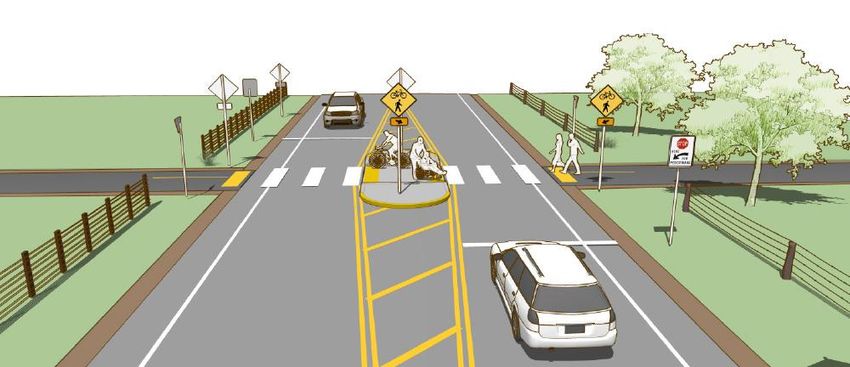
Install a Pedestrian Refuge
Island in front of the High
School
Note the walk through gap and the signs.
Pedestrian operated flashing signs are
better.
Imagine the
School here
Note the fencing
that guides
pedestrians to the
crosswalkThere are Solutions • Increase Police Monitoring of identified problem areas. • Improve driver awareness via reminders about speed limits, courteous behavior in the paper and at the High School. • Increased number of SPEED LIMIT signs on South Ave and on streets entering the neighborhoods
I look forward to our neighborhoods working
    together to address our shared issues

         Thank for your attention
Where Do Accidents Occur?
250
L&C Boundary
200
PERCENT L&C Boundary
150 Non-Junction 50.3 29.8
Intersection 24.1 31.2
100 Intersection-
14.5 6.3
Related
50 Driveway/Alley
11.0 32.7
Access Related
0Summary of L&C Traffic Data
Sentinel H S
Traffic circles
are not an
Lewis
&
appropriate
Clark
School answer
without having
analyzed traffic
distribution
data and speed
data
We need to be creative and effective in identifying
solutions based on data, not opinionYou can also read