DRAFT CONSERVATION AREA APPRAISAL SOUTHBOROUGH - Royal Borough of Kingston upon Thames - April 2009
←
→
Page content transcription
If your browser does not render page correctly, please read the page content below
Royal Borough of Kingston upon Thames

DRAFT CONSERVATION AREA APPRAISAL

         SOUTHBOROUGH

            April 2009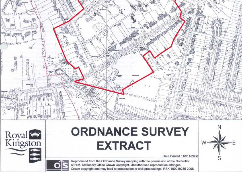
Contents
                                                             Page Number

1.0 Introduction                                             1
2.0 Planning Policy Context                                  1
3.0 Community Involvement                                    2
4.0 Location and Setting
      Location, Setting and Topography                       2
5.0 Historic Development                                     3-9
6.0 Character Analysis
      Definition of Character                                9
      Land Use and Activity                                  10
      Streets and Spaces                                     10-11
      Views, Landmarks and Focal Point                       11-12
      Public Realm                                           12
      Trees and Greenery                                     13
      Architectural Character                                13-15
              Listed Buildings                                       15
      Buildings of Townscape Merit                           15
      Building Scale and Form                                16
      Building Materials and Local Detail                    16
      Boundary Treatment                                     17
7.0 Assessment of Special Interest
      Assessment of Special Interest                         17
      Summary of Special Character and Appearance of         18

8.0 Boundary Review                                          19
      Areas for Inclusion
      Woodlands Road/Southborough Close (northern side)      19-20
      Herne Road (western end)                               20-21
      Corkran Road/Langley Avenue/Upper Brighton Road        21-22
      Lovelace Road                                          22
      Upper Brighton Road (southern end)/Hook Road           22-23

      Areas for Exclusion
      Penners Gardens                                        23-24
      Langley Road                                           24-25

      Conclusion                                             25-26
9.0 Management Strategy Programme                            26
      Key Matrix Characteristics                             26-27
      Assets of Southborough Conservation Area (Positives)   27
      The Extent of Intrusion or Damage to Southborough
      Conservation Area (Negatives)                          27
      Potential for New Development                          28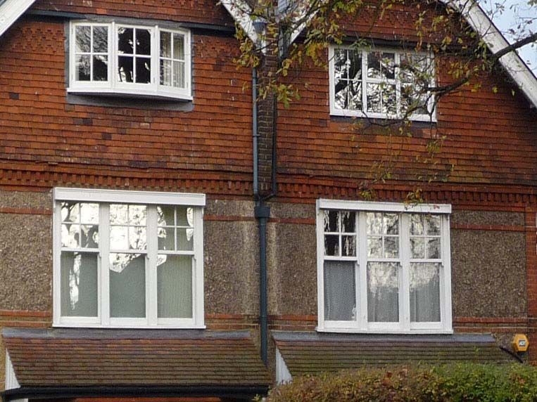
Opportunities for Enhancement                28-29

CONCLUSIONS / WAY FORWARD                            29

Appendix A                                           30
Summary report of Public Consultation on responses   31-39

Plans

1 Context
2 Location Plan
3 Historic Development
4 Land Use
5 Building Character Analysis
6 Townscape Analysis
1.0   Introduction

1.1   This character appraisal defines and records the special architectural and historic
      interest of Southborough Conservation Area, designated in 1979, extended in
      1989 and 1991. It provides a sound basis for control of development and for
      proposals to preserve or enhance the area as part of a future detailed
      management plan. The description of the area, in the designation report of
      November 1978 states that this is an area with “good examples of domestic
      architecture from the late Victorian era 1880-1900, a factor which contributes
      towards the present character of the area.”

1.2   A leaflet on this conservation area was published in 2001, a public realm audit in
      2008, and reference to Southborough Conservation Area is made in ‘Assessment
      of Surbiton Conservation Areas and Local Areas of Special Character’, section 8
      (2004). Other relevant background information includes original designation
      documents and the original decision to designate in January 1979. This was
      followed by the first proposal to extend the area in October 1988 with the
      decision to extend taken in January 1989. A further proposal to extend the area
      in June 1991 was approved on 11 September 1991.

2.0   Planning Policy Context

2.1   The legal basis for conservation areas is the Planning (Listed Buildings and
      Conservation Areas) Act 1990.

2.2   Conservation areas are designated under the provisions of Section 69 of the
      Planning (Listed Buildings and Conservation Areas) Act 1990. A conservation
      area is defined as “an area of special architectural or historic interest the
      character or appearance of which it is desirable to preserve or enhance”. Section
      71 of the same Act requires local planning authorities to formulate and publish
      proposals for the preservation and enhancement. National policy guidance is
      provided by Planning Policy Guidance Note 15 (PPG 15) Planning and the
      Historic Environment and PPG 16 Archaeology and Planning.

2.3   Royal Borough of Kingston upon Thames Unitary Development Plan (UDP) First
      Alteration (2005) contains the Council’s policies and proposals for development,
      regeneration and land use in the Borough. Policies which seek the preservation
      and enhancement of conservation areas are set out in UDP (Policies BE3 –
      BE4). Other relevant UDP policies that relate to conservation areas are Listed
      Buildings (BE5-BE7), Buildings of Townscape Merit (BE8) and Areas of
      Archaeological Significance/ Scheduled Ancient Monuments (BE19-20).

2.4   This appraisal should be read in conjunction with the relevant UDP policies,
      emerging Local Development Framework (LDF) policies and the national
      planning policy guidance and planning policy statements, in particular PPG 15.
      The layout and content follows current English Heritage guidance on
      Conservation Area Appraisals. As recommended in PPG 15, the general
      presumption should be in favour of retaining buildings which make a positive
      contribution to the character or appearance of a conservation area.

                                                                                       1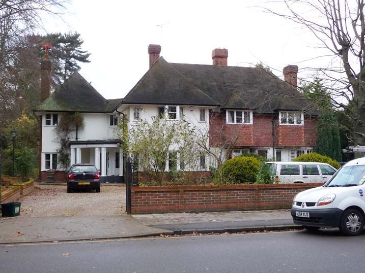
3.0 Community Involvement
3.1 In accordance with English Heritage advice, the Council’s brief included
requirement to involve key stakeholders in the appraisal process. The means
were by an initial questionnaire, stakeholder meetings and walkabout, which
formed the content of this appraisal.
3.2 On 13 March 2009, following the approval of a first draft by Kingston Council, a
copy of this appraisal and accompanying maps was posted onto the Council’s
website and deposited at Guildhall 2 for public consultation. A consultation leaflet
notifying local residents was sent to all addresses within the conservation area
and the following stakeholders:
- Southborough Residents’ Association
- Herne Road Association
- Penners Gardens Residents' Association
- SCAAC
- Executive Member for Planning and Regeneration
- Co-Chair Surbiton Neighbourhood Committee
- HE Champion
- Surbiton Hill Ward Councillors
By the close of consultation on the 10 April 2009, 96 individual responses had
been received. Careful regard to the responses have been paid in this text.
These are reported on at Appendix A.
4.0 Location and setting
Location, Setting and Topography
4.1 Southborough Conservation Area lies south of Kingston Town Centre and east of
Surbiton Town Centre. The area extends from the boundary with Elmbridge
Borough in the west, to Hook Road and Upper Brighton Road to the east. The
south of the area is defined by Hearn Road, whilst a continuation of Upper
Brighton Road defines the northern edge. There are 444 postcode properties in
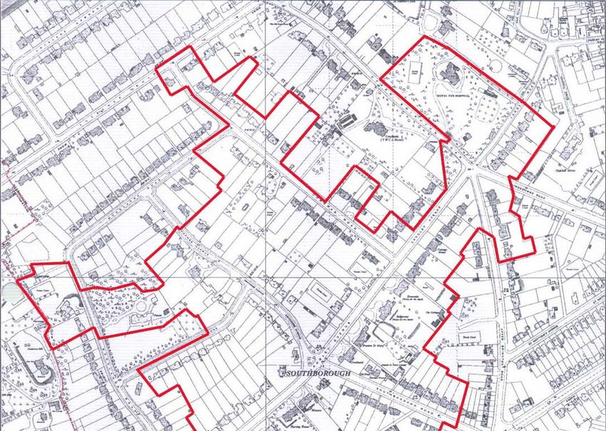
an area of 7.5 hectares (Plan 1: Location Plan).
4.2 To the northeast lie Oakhill Conservation Area and Walpole Road Local Area of
Special Character (LASC). To the east lie St Matthews Avenue LASC (See Plan
2: Context).
4.3 Land south of Langley Avenue is generally flat with a gentle gradient rising east
to west. The area north of Langley Avenue slopes downwards towards the length
of Woodlands Road running east to west. The junction of Langley Avenue,
Langley Road, Kingsdowne Road and Upper Brighton Road are at the top of the
hill which forms a gateway to the Southborough Estate from the north end of
Langley Avenue.
2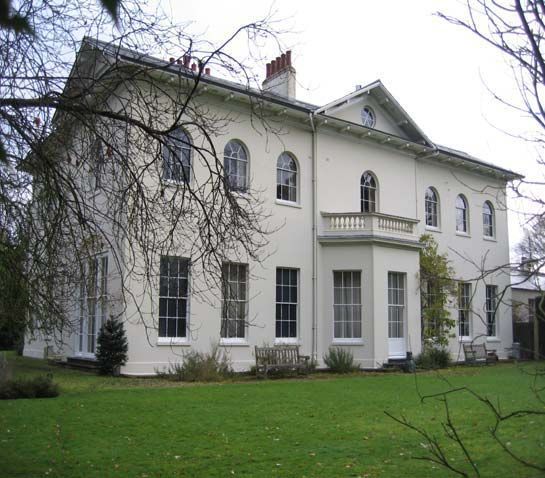
A ‘Gateway’ - junction of Langley Avenue, Kingsdown, Langley and Upper Brighton Roads

5.0   Historic development

5.1   Plan 3: Historic Development shows the approximate original dates of the
      buildings in the conservation area, according to a succession of Ordnance
      Survey maps from 1865 to 1987.

5.2   The Conservation Area originally formed part of the grounds of Southborough
      Estate, centred on Southborough House. Thomas and Sarah Langley
      commissioned the famous Regency architect, John Nash, to build Southborough
      House on the former Kingston Common in 1808. The main house (14 Ashcombe
      Avenue), the garden building to the west, and Southborough Lodge (16
      Ashcombe Avenue) are Listed Grade II buildings and the oldest buildings within
      the area. The Ordnance Survey dated 1868 shows Southborough House and
      Southborough Farm (now demolished) as the only properties within the
      boundaries of Brighton Road, Ditton Road, and the Portsmouth to London
      Railway line.

5.3   Between 1880 and 1895, Langley Avenue and Corkran Road, previously an
      unmade road and track, were formed into good carriageways. The south side of
      Langley Avenue and the east side of Corkran Road were sold off in large plots
      and developed forming part of a wider suburbanisation of Kingston. A
      comparison between the 1895 and 2008 Ordnance Survey shows that 2, 4, 6, 10,
      12, 4, 16, 18, 20, 22, 24, 28, 30 Langley Avenue and 17, 31, 33 Corkran Avenue
      have survived to date. Southborough House was purchased by James Cundy in
      1885. It retained a generous plot and gained a gardener’s lodge for at the

                                                                                         3
entrance in Langley Avenue in 1884, and a coachman’s lodge adjacent to the
      gateway to Carriage Drive in 1891. Both lodges still remain in their original form
      at 25 Langley Avenue and 22 Corkran Road, respectively.
5.4   Following the death of James Cundy in 1909, ownership of Southborough House
      passed to his widow, Elizabeth. Elizabeth objected to a proposed Town Planning
      Scheme announced in 1913 by the Urban District Council of Surbiton, which led
      to a formal agreement on 30 October 1913 between the Urban District Council of
      Surbiton, Elizabeth Cundy and the mortgager of Southborough House (A F Hook)
      relating to all the land bounded by the north side of Langley Avenue, the west
      side of Corkran Road, the south of the properties in Lovelace Road and the
      boundary with Long Ditton. The agreement established that if any part of the
      Southborough estate was developed it should be within the following constraints
      to be incorporated in the deeds:
      - any development was to be of a detached and semi-detached houses to the
          value of £800 each and £1200 per pair respectively;
      - the houses were to be set back 50 feet from Langley Road and 30 feet from
          Corkran Road;
      - the construction of new roads was to be limited to one linking Corkran Road
          and Langley Avenue and one dissecting the remaining area; and
      - no industrial uses, noxious uses, public house or off license were to be
          established.

5.5   In 1920 following the death of Elizabeth Cundy all land was passed to the
      mortgager and subject to the agreement, Woodlands Road was developed
      linking Corkran Road and Langley Avenue, and was sold in plots to individuals as
      shown on the 1932 Ordnance Survey. The plots are narrower than the plots on
      Langley Avenue and Corkran Road, but still ample in size. By the 1950s, most of
      the development which now constitute the conservation area had taken place,
      with the exception of Malcolm Drive, Redwood Walk, Kirkleas Road and Copse
      Glade, and infilling of vacant plots or redevelopment of earlier buildings that
      continued intermittently.

      Woodlands Road developed from the 1920s

                                                                                      4
Extract from Ordinance Survey map, 1868

                                          5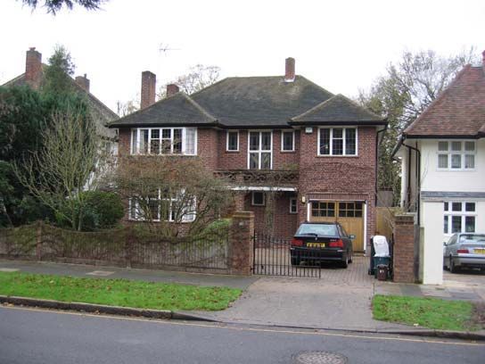
Extract from Ordinance Survey map, 1895

                                          6
Extract from Ordinance Survey map, 1932

                                          7
Extract from Ordinance Survey map, 1952-1959
85.6 Notable buildings that have been built on the site of demolished buildings from
1866-1895 include:
- 13 & 15 Corkran Road
- Pennerly
- 5, 7a, 7, 26 Langley Avenue
- Croylands Drive
- 22 Hook Road
- Penners Gardens, once the Old Eye Hospital, which was once the site of
Southborough Farm, demolished sometime during the 1920’s.
Art Deco flats at 22 Hook Road replaced a house of about 1875
5.7 Notable buildings that have been considerably extended between their
construction date & early 1930’s:
- 9 & 11 on the corner of Corkran Road and Langley Avenue.
- 24 & 28 Langley Avenue
- 81, 99,102, 105, 106 & 106a Ditton Road
- Southborough Nursing Home, which combines 12-14 Langley Avenue.
- Parts of Shrewsbury House School are built on the site of ‘The Mount’. Main
house has been extended with some original outbuildings demolished.
6.0 Character Analysis
Definition of Character Areas
6.1 The development sequence can be traced through the OS map analysis, from
the older, largest houses to modest suburban types which were predominant
from about 1933. Although this has given each street a distinctive character,
overall there appears little reason to identify them as constituting sub areas. The
basis of the area’s character is of mainly detached houses in generous,
sometimes very large plots, which themselves are well endowed with a variety of
tree species. Tree planting also extends to virtually all streets. These common
properties give the area a cohesive character.
9Land Use and Activities
6.2 The primarily land use is residential (Plan 4: Land Use). The majority of houses
appear to be in single occupation with no obvious signs of subdivision or
multiple-occupation, with the notable exception of some large villas on Lovelace
Road, Langley Avenue and Ditton Roads. Former large houses at Nos. 11, 9, 12-
14, 24, 45 Langley Avenue, and Nos. 96, 101,108 Ditton Road have been
converted to residential care homes
6.3 The most significant non-residential use in the area is Shrewsbury House School,
which occupies extensive grounds on the south side of Ditton Road, opposite its
junction with Langley Avenue at 107 Ditton Road. The buildings comprise the
highly distinctive former Victorian mansion and lodge, and modern science
blocks, sports hall and ancillary buildings. 23 Upper Brighton Road is occupied
by Surbiton Day Nursery.
6.4 The streets are subject to controlled parking, limiting daytime parking. Disturbed
only by local traffic, the conservation area has a quiet residential atmosphere
within its core. The peripheral Upper Brighton Road/Hook Road, which intersects
the conservation area to the east, is a busy main north to south thoroughfare and
a main bus route.
Streets and Spaces
6.5 The conservation area is mainly composed of detached buildings on an irregular
grid of cross-cutting streets. Buildings tend to front onto streets, behind uniform
front garden set backs, resulting in an established building line. Front gardens,
separating building from the public footways and roads are an important
component of the suburban character.
6.6 Plot sizes vary from street to street. Larger plots are mainly on Ashcombe
Avenue, Corkran Road, Langley Avenue and Southborough Close. More modest
suburban plots line Copse Glade, Halsham Close, Kirkleas Road, Malcolm Drive,
Redwood Walk, Southborough Road and Southborough Road the Lane. A
feature of each street, however, is its largely consistent plot widths and building
size. Ditton Road and the upper west side of Woolands Road (20, 35-43) depart
from this prevailing pattern, with irregular plot and building sizes.
6.7 The generous set backs convey a spacious character on the north side of Ditton
Road, Langley Avenue, Southborough Road, Ashcombe Avenue and Corkran
Road. In contrast, with minor set backs and smaller plots, Copse Glade, Halsham
Close, Kirkleas Road, Malcolm Drive, Redwood Walk, and Southborough Road
the Lane feel more enclosed.
6.8 There is no area of public open space of note, although there are significant
grassed verges at two key nodes: junction of Langley Avenue, Langley Road,
Kingsdowne Road and Upper Brighton Road, and crossroad of Ashcombe
Avenue, Langley Avenue and Southbrough Road. These can be described as
informal open space, crossed by pedestrian paths with some shrubbery within.
Some seating is present but not conspicuous. These spaces are unsuited to
leisure due to their size, shape and roadside location, but they do soften the
10appearance of the junctions and provide more green and leafy settings for
buildings.
6.9 Open space within the conservation area are generally private gardens belonging
to the properties. In many cases the rear gardens are hidden from public view but
open out once within the sites. When grouped together, these gardens form large
and distinctive spaces which are a major feature of the area. By contrast, tightly
packed developments on garden lands which have been sold off have eroded the
integrity of the area.
Views, Landmarks and focal point
6.10 Views through the conservation area are limited due to the topography and street
layout. The best views are therefore to be seen within the Conservation Area
along individual streets of fine houses. The most important views are the south to
north views along Woodlands Road, and east to west along Woodlands Road
and Langley Avenue. Also of importance, gaps between the detached buildings
allow intriguing glimpses to space at the rear forming a backdrop or through
views. These make an important contribution to local character.
6.11 There are a number of buildings that act as important local landmarks. These are
marked on the townscape analysis map (Plan 6: Townscape Analysis). An
attractive building with distinctive chimneys, 30 Woodlands Road (Grade II
Listed) is prominent in views north along Woodlands Road. The scale, setting
and use of Shrewsbury House is a landmark at Ditton Road and Langley Avenue
junction. The Lodge of the Former Eye Hospital on Upper Brighton Road is a
distinctive and attractive feature on the boundary of Penners Gardens.
30 Woodlands Road and Shrewsbury House
6.12 Set back from the road and mature hedge, the Grade II Listed Southborough
House and Southborough Lodge are obscured from a public vantage point.
6.13 The junction at Langley Avenue, Langley Road, Kingsdowne Road and Upper
Brighton Road, described in paragraph 5.10 is a key focal point, acting as an end
stop to views from Langley Avenue, Langley Road, Kingsdowne Road and Upper
Brighton Road. The junction of Ashcombe Avenue, Langley Avenue and
Southbrough Road, also described above, is a focal point at the centre of the
11conservation area. It is prominent in views along Longley Avenue and acts as an
end stop to view along Ashcombe Avenue and Southbough Road.
Public Realm
6.14 Footways are predominantly modern i.e. tarmac or concrete slabs. Where found,
large proportions of concrete slabs are in poor condition and require
maintenance or replacement. In places tree roots are lifting and breaking paving
surfaces. Highway repairs and crossovers are noticeable due to the use of
differing materials, giving the footway a patchwork appearance.
Typical patchwork surfaces of footways
6.15 Street lighting is almost exclusively modern and unremarkable.
6.16 There is no uniform style or method of fixture of street names within the area.
However, the older, traditional style signs are more appropriate to the period
character of the buildngs and should form the pattern for all signing in future.
Inconsistent design and placement of signage through the conservation area 12Trees and Greenery
6.17 Trees are a particularly special feature of this area and a key element in the
landscape. The area is epitomised by properties situated in generous plots with
extensive tree and shrub planting throughout. The scale is reflected in the
planting, and large trees and shrubs are prevalent. Smaller trees and shrubs are
of secondary importance but contribute to the overall verdant character of the
area.
6.18 Trees and shrubs within back gardens form a backdrop to the buildings. Trees
and shrubs to the front commonly screen the building from the street and where
there is a break in the planting; glimpses of the building can be seen. This
provides in an important contrast to the hard architecture and making a valuable
contribution to the streetscene.
6.19 With the exception of Corkran Road, the main roads within the area are tree lined
which further softens the streetscape and contributing to the ‘green character’.
However, damage to pavements caused by roots is apparent. Trees on Langley
Avenue and Lovelace appear to be original planting becoming mature over the
years. There are younger semi-mature trees on Southborough Road and
Southborough Close, and saplings on Ashcombe Avenue and Ditton Road.
There is a mixture of species, although the Sycamore, Horse Chestnut, Silver
Birch, Oak, Fir, London Plane are distinctive.
6.20 The most significant street and garden trees are covered by Tree Protection
Orders, which are marked on the Townscape Appraisal map (Plan 6: Townscape
Analysis). The grass verges on Ashcombe Avenue, Ditton Road, Southborough
Close, Upper Brighton Road and Woodlands Road also make a positive
contribution.
Architectural Character
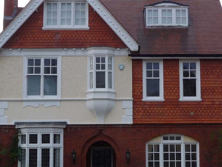
6.21 The conservation area provides a good example of the well to do entrepreneurial
mid-late 19th century estate, later merging into more typical general middle class
expressions of the early-mid 20th Century. There is a mix in individual
architectural design, but design has been primarily influenced by Victorian Gothic
moving towards the ‘Aesthetic’, Queen Anne and Arts and Crafts movement by
the late 19th Century. The architecture was more decorative and harked back to
a more rural way of life. Common features include:
- Asymmetry
- Accentuated gables
- Prominent and decorative chimney stacks
- Exposed brick and beams to explain construction
- Woodwork framing the porches
- Painted woodwork
- Tiling
- Painted roughcast render
- Pebble dash
13Asymmetry, accentuated gables, prominent chimneys, and painted woodwork
Pebble dash, tiling, roughcast render and exposed brick work
146.22 Post-war backland housing development at Malcolm Drive, Redwood Walk,
Kirkleas Road and Copse Glade is modern, of no particular style.
6.23 Overall, architectural integrity is largely intact with few inappropriate alterations.
The most notable negative alterations are the removal of wooden porches and
windows, the removal of prominent and ornately detailed chimneys and the
addition of inappropriate box dormers.
Listed Buildings
6.24 Within the area there are 4 Grade II Listed buildings; Southborough House (14
Ashcombe Avenue), the garden building to the west, Southborough Lodge (16
Ashcombe Avenue), and 30 Woodlands Road.
6.25 Designed by John Nash, Southborough House is a 2 storey, stucco house with a
slate roof. Architectural details include deep wood cornice with brackets widely
spaced, a 1st floor semi-circular sash, with radiating bars, square headed
windows to ground floor, 4½¨ reveals and a centre pediment with circular oculus.
The single storey garden building and Southborough Lodge are listed for group
value.
6.26 30 Woodlands Road was built by Thomas Henry Wilson in the style of Vernacular
Revival. Architectural details include hand made brown and buff brick, timber
frame panels, stone dressings, tile hanging and tile roof. All main windows have
square leaded panes. There is no attributed architect, but the quality of design,
materials and craftsmanship is extremely high. It remains almost unaltered,
retaining original surfaces and materials.
Buildings of Townscape Merit
6.27 The following unlisted buildings have been identified as buildings of townscape
merit. They are good examples of unaltered historical buildings where their style,
detailing and building materials makes a positive contribution to the streetscape:
- 1, 3, 5 and 22 Corkran Road
- 92, 93, 96, 102-108 (even) and Shrewsbury House School Ditton Road
- 2-18 (includes Coinage House, Draconia, Ridgeway, Preston St Mary and
Crowhurst), 22 (Monaro), 24 (Hamilton Nursing Home) , 25/25a, 28, 30
(Mendips) and 45 (Bourne House) Langley Avenue
- 15-25 (odd) Langley Road
- 19, the Old School House, 21, 23 and Lodge to Former Eye Hospital Upper
Brighton Road
6.28 It is recommended that 8-12 Ashcombe Avenue (Copse House) is elected as a
building of townscape merit. Although there are some alterations, most notably
its subdivision, its architectural style, detailing and materials enhance the
streetscene.
15Building Scale and Form
6.29 Two to two and a half storeys are the norm, although many have semi-
basements.
Building Materials and Local Detail
6.30 Despite the wide range of building age and architectural design, the use of the
same palette of materials link the buildings within the area. The dominant
building material is red and yellow brick laid in Flemish bond with contrasting
detailing, such as painted render, stucco and hanging clay tiles, used in the
articulation of frontages.
6.31 Natural red clay tiles dominate the roofscape. Southborough House incorporates
a slate roof, but this is unusual. The chimney stacks, which project from the
roofline of houses and which are highly visible from the street, are usually red-
brick with terracotta pots.
6.32 Original windows and window and door joinery on the buildings from the mid to
late 19th Century were invariably timber with authentic leaded glass, but have
often been replaced with uPVC or aluminium, in which the lead is glued to sheet
glass.
uPVC replacement windows, original wood and metal windows
16Boundary Treatment
6.33 Where present, front boundary walls are almost invariably a low red brick or
stone wall often supplemented by hedges or other garden foliage. Wooden and
iron fencing are present but uncommon.
Typical boundaries
7.0 Assessment of Special Interest
7.1 Although making judgments about buildings can never be a perfect science, the
primary characteristics which define Southborough can form a basis for
measuring a building’s contribution to the conservation area, i.e. whether its
preservation is essential, highly desirable or tradable for a greater benefit.
7.2 Using the suggested checklist from English Heritageas a basis, the key
characteristics set out in section 8 were identified and used to identify positive,
neutral and negative buildings. A score of 10 or over is a positive building, 5-9 is
neutral and a score under 5 is categorised as a negative building.
7.3 As a well-defined residential group, the properties make a positive contribution to
the character of the conservation area (Plan 5: Building Character Analysis).
However, the evaluation is primarily based on an assessment of elevations
17visible from a public vantage point. As such, it is only a guide and should be used
with caution, particularly where it may be difficult to exclude received values.
Summary of Special Character and Appearance of Southborough Conservation Area
7.4 The special architectural or historic interest that provides the character of
Southborough Conservation Area derives from the following features:
Historic interest
x Southborough House and Southborough Lodge, Grade II Listed buildings
x Significance of the form of development determined by the 1913
Agreement
x A mid to late 19th and early-mid 20th Century entrepreneurial/middle-
class suburban layout
x 19th and 20th century entrepreneurial/middle-class architectural
development
Character/Land Use
x Predominately residential use
x Mainly detached, red-brick houses in large plots, set back from road
x Linear Streets
x Mature gardens and extensive tree cover
Architectural Interest
x Speculative mix of building styles ranging from large villas on Ditton Road
to modest suburban types on Woodlands Road and cottages on Herne
Road
x Strong arts and crafts style and Italianate buildings throughout the area
Townscape Features
x Consistency in street layout, building footprint, density of residential
development, defined plot boundaries and gaps between buildings
x Broad consistency on height and scale of 2-2.5 storey southwest of Upper
Brighton Road
x Strong linear frontages
x Current series of individual houses and gaps with glimpses of trees and
hedges between and behind them
x Mature trees and greenery
x A topographical edge with the gateway of the Estate at the top of the hill
approaching from the NE of Langley Avenue
7.5 These common properties give the area a cohesive character as an early
residential suburb of Kingston Town Centre dating from the mid 19th century,
Southborough Conservation Area.
188.0 Boundary Review
8.1 Under section 69 of the Planning (Listed Buildings and Conservation Areas) Act
1990, Local Planning Authorities have a duty to review their areas from time to
time, to consider whether existing conservation area designations are still
warranted, and whether any new areas of designation should be made.
8.2 The Study Area for this appraisal was designed to reflect this, as well as the
current English Heritage guidance document on Conservation Area Appraisals.
This incorporates most of what comprises the fringe area of the pre-review
boundary and areas of land which might merit inclusion within revised
boundaries. In addition, the obverse imperative of the guidance is that areas
which may no longer merit inclusion should also be identified. The boundary
review identifies both categories as follows:
Areas for Inclusion
i) Woodlands Road/Copse Glade/Southborough Close (northern side)
Reasoned argument
8.3 The majority of buildings on Woodlands Road date from the interwar period
1915-1938 period. A small number of buildings in Woodlands road and those in
Southborough Close are post 1945. With the exception of no.57, 65 and 69, most
individual properties are not of exceptional merit. They are mainly products of
relatively unsophisticated designers and local developers or building companies.
However, the properties have considerable group value as notable examples of
good quality middle class housing, as determined by the 1913 Agreement
referred to above. It forms a distinct and cohesive townscape by virtue of the
similarities in street layout, plot size, density, well defined boundaries, trees and
landscaping, and topography, consistent with the characteristics of the existing
Conservation Area.
Woodlands Road
8.4 Together with Langley Avenue and Corkran Road, Woodlands Road and
Southborough Close add a significant chapter to the historic record of
19development of the Southborough Estate and reinforce the integrity of the
conservation area.
8.5 Whilst most buildings have an individual design, there are also instances of
duplicate house designs, each group presumably built by the same builder. For
example, nos. 69 and 71 Woodlands Road, and 79 and 83 Woodlands Road.
These houses exemplify late 19th century building practices where a variety of
builders were responsible for single houses or groups of houses on the same
street.
8.6 From the south end of Woodlands Road there is a significant vista along the
subtle curves of the road, toward the north. This establishes a strong sense of
place and continuity, contributing to the character of the wider area.
8.7 Copse Glade makes a neutral contribution and should be included within the
conservation area to avoid an internal gap.
8.8 Sylvan Gardens, which connects with the top end of Woodlands Road is
excluded because it is a self-contained cul-de-sac of modern housing, which
lacks any architectural or group distinction and does not therefore contribute to or
reinforce the special interest for which the conservation area was designated.
ii) Herne Road (western end)
Reasoned argument
8.9 The buildings at the western end of Herne Road (formally known as Hookhearn
Common), fall mainly into two groups or types: small detached and terraced
vernacular styled cottages and the more imposing Italianate group at Nos. 48 to
54. The cottages display considerable variation in style, small plots, scale and
mass, in contrast to many of the larger houses and plots elsewhere in the area.
Yet, the majority of buildings are of the same early to mid Victorian period as the
original houses on Langley Avenue, Corkran Road and Ditton Road, thereby
predating many houses already included within the area. Their exteriors are still
substantially intact, with original details. Where alterations have been
undertaken, they have generally been sympathetic. A cohesive character is
defined by age, narrow front gardens (with the exception of 49 and 51 Herne
Road that open directly onto the carriageway), cottage appearance, narrow
pavements, proximity of properties and hilltop location.
Herne Road, Italianate villa and vernacular styled cottages
208.10 ‘Sherwood’ is 2 blocks of flats dating from 1960. The spacious site originally
formed part of the grounds of a significant house, dating from the 1880s. The
setting retains a number of significant mature trees from the old estate. However,
guidelines in PPG15 strongly suggests that designation is unlikely to be
appropriate as a means of protecting landscape features, except where they form
an integral part of a historic parks or gardens. Instead, trees may be protected by
means of a tree preservation order. Therefore, these flats have been excluded
from the revised boundary.
iii) Corkran Road/Langley Avenue/Upper Brighton Road/
Reasoned argument
8.11 The houses proposed for inclusion lie within an area fronting onto Corkran
Avenue, Langley Avenue and Upper Brighton Road. Most date from the 1960s.
Their street façades, siting, form and proportions are closely modelled on the
original detached houses in these roads. Together they complete a cohesive
street and townscape, consistent with the characteristics of the existing
Southborough Conservation Area.
3 Langley Avenue
8.12 No. 3 Langley Avenue is a well proportioned house on a generous plot, set back
within a landscaped garden. It exhibits most of the features consistent with the
earlier ‘Southborough’ character. In a report for Listing consideration in 2007,
English Heritage declared that it is part of the cumulative effect of the suburban
environment of characterful, well spaced houses set in landscaped gardens, and
it makes a positive contribution to the local streetscape. It follows that is should
be included within the conservation area. Nos. 5-7a Langley Avenue are
replacements of two earlier houses but make positive contribution and together
with 1 Langley Avenue, which is identified as a neutral site, should be included to
maintain a consistent pattern and in order to avoid an internal gap.
218.13 Fronting Upper Brighton Road, Oakdene appears on the 1950s OS map, whilst
the other two, Hillcrest and Cumbrae appear to date from the 1960s. Lying
immediately to the west of the junction of Upper Brighton Road, Langley Avenue,
Kingsdowne Road and Langley Road, their foreground is an informal green
triangle. Although of unexceptional design, this house group is consistent with
the area generally in its generous plots, scale and pattern of development. The
group, greenery and planting form an appropriate edge and introduction to the
area. The impression of both a topographical and architectural edge is reinforced
by two other factors: the strong barrier of the principal route, Upper Brighton
Road and, the differences in proportion, scale, architectural expression and
group character of buildings to the east and northeast of the junction.
iv) Lovelace Road
Reasoned argument
8.14 Lovelace Road was formally an area of substantial Victorian and Edwardian villas
developed as an outer suburb to Surbiton. Many of these villas have been
subdivided into flats, but the Old Coach House and Bibury on Upper Brighton
Road, and Raymond Court, Shelley Court, Byron Court, 1, 2 and 3 Lovelace
Road retain original form, features and detailing. They are also good examples of
its formal layout on the linear avenue with mixed scale development situated on
wider plot widths. Substantial mature planting both on street and within plots
unify the buildings with the character of the conservation area.
Lovelace Road, Victorian villas
v) Upper Brighton Road (southern end)/Hook Road/Southborough Road
Reasoned argument
8.15 Proposed extension to take in the Maypole (a 19th Century pub at 2 Hook
Road), 2 to 20 Hook Road (even numbers), 16 to 20 and 36 to 42 Upper Brighton
Road (even numbers) which are characteristic of the conservation area in terms
of building type, architectural appearance, function and location. The Maypole is
also an important townscape feature as a building of townscape merit and
located on a distinctive corner at the junction of Hook Road and Ditton Road.
228.16 It is also proposed to extend the boundary to include The Shrubbery (22 Hook
Road), an art deco block of flats, which, although a divergent building type,
makes an distinctive but positive contribution to the townscape and is worthy of
protection on architectural grounds.
The Maypole and The Shrubbery
8.17 15, 17 and19 Southborough Road are post war houses form part of the
cumulative suburban character of Southborough Road. They make a positive
contribution to the character of the conservation area should be included to
maintain a consistent pattern and to strengthen the integrity of the street.
Areas for Exclusion
i) Penners Gardens
Reasoned Argument
8.18 Penners Gardens is a recent gated development sited on the northeast side of
Upper Brighton Road, fronting onto Langley Road. The site originally formed part
of the Southborough Estate before the land was purchased by a Mr Eglington
who erected a red brick, Gothic style house in 1870. The house was known as
‘Southborough’ or 17 Upper Brighton Road. In 1941 the Royal Eye Hospital and
subsequently the Department of Community Health and Medicine adapted the
building, with ad-hoc alterations and extensions over time. In the mid 1990s the
hospital was demolished and the site redeveloped as Penners Gardens.
Penners Gardens view from Upper Brighton Road and within the site
238.19 The site had been considered for conservation area designation in 1988, but due
to outline permission granted on appeal for the development on 97 flats the
grounds for inclusion had been compromised. When the permission failed to be
implemented, the Conservation Area was extended in 1991 to include the
hospital complex as a surviving example of a fine Victorian Mansion set in its
original, mature grounds, notwithstanding a second appeal decision allowing its
demolition and redevelopment. A subsequent application for the 74 dwellings that
exist today was approved in 1997.
8.20 Reference to Southborough Conservation Area is made in ‘Assessment of
Surbiton Conservation Areas and Local Areas of Special Character’, section 8
(2004), however, this is the first full appraisal since the development has been
completed. The buildings fronting Langley Road, whilst obviously intended to
reflect the Victorian villas opposite, fail to achieve sufficient architectural interest
to justify having preserved or enhanced the character or appearance of the
Conservation Area. The development to the rear, though pleasant and
workmanlike, likewise has no special interest. For this reason, it is proposed that
Penners Gardens is excluded. The original lodge is however proposed for
inclusion as the sole surviving authentic building of the site, which remains
largely unaltered is of architectural interest related to the conservation area.
8.21 A number of mature trees and some of the 19th century boundaries make a
positive contribution to the appearance of the area and an attractive backdrop of
the road, but do not justify designation of the site alone. Therefore, these
features have been excluded from the revised boundary.
ii) Langley Road
Reasoned argument
8.22 15 to 25 Langley Road are Victorian houses of Townscape Merit, located in well-
defined plots and surrounded by mature trees and landscaping consistent with
the characteristics of the existing conservation area. However, notwithstanding
their acknowledged character, they are very different from the asymmetrical
informality of the houses that make up the rest of the Conservation Area. Upper
Brighton Road intersects Langley Road from Langley Avenue, physically and
visually separating 15 to 25 Langley Road from the main body of Southborough
Conservation Area. These two factors together suggest exclusion from
Southborough CA with inclusion with the adjoining Oak Hill Conservation Area,
which is easily achievable as the group lies between the Southborough and
Oakhill areas, or independent designation.
15-19 Langley Road and 19-19a Upper Brighton Road 248.23 19 Upper Brighton Road, a 4 storey Victorian house of Townscape Merit built in
1873, is a continuation of the scale and style found in Langley Road. 19a and
19b Upper Brighton Road are 2-storey red brick houses built in 1954 on land
forming part of the curtilage of 19 Upper Brighton Road. Although unremarkable
in appearance, they are sited on generous plots. Their landscaping to the front
forms a visual link with 19, 21 and 23 Upper Brighton Road. 21 Upper Brighton
Road and 23 Upper Brighton Road are attractive houses of Townscape Merit.
Both 21 and 23 Upper Brighton Road post-date the main development of the
southern side of Langley Avenue, built between1880-1900. Because these
properties are stylistically similar to the main area west of Upper Brighton Road,
they should remain within the Conservation Area, notwithstanding the barrier
effect referred to above.
Conclusion
8.24 It is proposed that the additional properties be included:
- Ashcombe Avenue 1, 4, 6, Mulberry House
- Corkran Road 2-6, 19-27, 35, 37-41
- The Drive 2, 3, 21
- Ditton Road 78, 107
- Herne Road, 44-74, 49, 51
- Hook Road 2-22
- Langley Avenue 1-7a
- Lovelace Road 1, 2,3, Byron Court, Shelly Court, Raymond Court
- Southborough Close 8-14
- Southborough Road 15-19
- Upper Brighton Road, 8, 10, 10a, 12, 14-20, 36-44,Cumbrae, Oakdene,
Bibury, The Old Coach House
- Woodlands Road 1–33 2-24, 40-64, 49-87
- Copse Glade
8.23 The proposed Southborough Conservation Area as a whole would includes:
- Ashcombe Avenue
- Brighton Road (Ravens Court)
- Copse Glade
- Corkran Road
- Ditton Road (74-108, 114, Ilex Holme and Shrewesbury House School)
- Dunton Close
- Hailsham Close (12-18)
- Herne Road (44-74. 112)
- Hook Road (2, 8-22, 24-42, 56-70, St Bernard's House and Warwick
Court)
- Kirklees Road
- Langley Avenue
- Lovelace Road (1-2, 14, Beech Court, Byron Court, Roymont Court and
Shelly Court)
- Malcolm Drive
- Redwood Walk
- Southborough Close
- Southborough Road (1-20, Amla Lodge and The Stables)
25- Southborough Road, The Lane (Cedar Lodge, Glenmore, Monaro
Cottage, and The Grange Cottage)
- The Drive
- Upper Brighton Road (2, 8-20, 17-23, Bibury, Oakdene, Old School
House and The Coach House)
- Woodlands Road
9.0 Management Strategy Programme
9.1 The 14 defining characteristics of the area, set out below, were used as a tool in
assessing the contribution of existing development to the character of the area,
and can be used in assessing the level of contribution made by any proposed
development to the conservation area.
CHARACTER ANALYSIS Key Matrix Characteristics
1. Plot size
typically large outer suburban, approx 10-25m width, 25-80m depth
2. Building type
detached house, with integral, attached or detached garage, (with some exceptions, e.g.
villas and flats to the east of Upper Brighton Road)
3. Building form/massing
predominantly orthogonal, with an asymmetric composition, projecting/receding
elements, vertical emphasis and prominent chimney stacks
4. Storey height
Mainly 2-2.5 stories, a few three storey villas (excluding any roof dormers)
5. Walling materials/colours
elevations composed of red/brown brick, roughcast, stucco, or half timbering
6. Roof form
steeply pitched, hipped and/or gabled. Many with oversailing eaves
7. Roof materials
hand or machine made clay tile or natural slate
8. Opening proportions
window divisions have a vertical emphasis
9. Fenestration patterns/materials
windows painted softwood or metal casements, with glazing bars or leaded lights, singly
or grouped
10. Boundaries and front gardens
front boundaries timber fencing or low brick walling with primarily green front gardens
11. Planting
Larger gardens’ mature trees and street trees are principal features.
2612. Ornament
Better houses display variety of ornament, including distinctive plasterwork, mouldings,
brick details and metalwork
13. Artistic intent
Some better, usually larger houses are a higher architectural class, possibly by a
learned professional designer. Some documented in English Heritage survey.
14. Integrity
Most houses’ original external appearance more or less intact, with little or no
incongruous alteration or extension.
9.2 From these, the indicators that follow take forward a character analysis from
which further decision making and priorities can be set. The assessment of
positive and negative impact informs how the work of a management strategy
should be progressed. The management strategy will contain ideas, actions and
timelines for promoting the further preservation and enhancement of the
Conservation Area.
Assets of Southborough Conservation Area (Positives)
i) Predominant residential use resulting in quiet residential atmosphere;
ii) Linear, formal streetscenes;
iii) Most of the buildings make a positive contribution to the conservation
area and largely retain architectural integrity;
iv) Consistent materials palette that unifies the conservation area;
v) Large plots and set back of most houses resulting in a spacious
character;
vi) Mature front gardens and street trees emphasising the suburban
environment; and
vii) The area is generally well maintained;
The Extent of Intrusion or Damage to Southborough Conservation Area (Negatives)
i) The removal of front boundaries. The lack of boundaries detract from the
high standard of design and detailing of the properties and reduce the linear
emphasis;
ii) The loss of front gardens for parking, which detracts from the high standard
of design and detailing of the properties and reduces the verdant character
of the area;
iii) Incremental loss of original architectural details such as wooden porches,
chimney and traditional windows and doors, which erode the character and
appearance of the area;
iv) Scale and design of extensions to properties;
v) Modern street lighting columns; and
vi) Inconsistent placement and style of street names.
27Potential for New Development
9.3 Plan 5: Building analysis has identified no negative buildings, although there are
a number of neutral properties where any proposal to redevelop would be
expected to enhance the character of the area.
9.4 The substantial plots may be viewed as having development potential; however
in determining the impact of any proposal the Council will take into account the
effect on the character of the conservation area in accordance with UDP policies
BE3, BE4, BE5, BE6, BE7, BE8, BE19 and BE20, emerging Local Development
Framework (LDF) policies and the national planning policy guidance and
planning policy statements. In addition the council will take into account the
impact of proposed use, density, scale and massing, layout and design of
proposed on amenity in accordance with relevant UDP and emerging LDF
policies.
Opportunities for Enhancement
9.5 There is potential to improve the character of the conservation area through the
following methods:
- The consistent application and amplification of conservation area policies
(BE1-7) to new development, extension and alterations subject to planning
permission
- The preparation and promotion of supplementary design guidance and
development briefs for the whole conservation area;
- Applying further control through Article 4(2) directions where specific control
over development / permitted development is required, primarily where the
character of an area of acknowledged importance would be threatened,
accompanied by site specific design guidance;
- The monitoring of breaches of planning controls and ensuring that
unauthorised work is the subject to a retrospective planning application and
taking enforcement action if necessary;
- The review of buildings and structures of local architectural or historic
interest for inclusion on a local list, and appropriate policies for their
retention and improvement.
- Consideration by the Royal Borough of Kingston of the effect of the use of
materials, and design and placement of street furniture and signs in the
public realm.
- In partnership with Highways and Transport, a programme of maintenance
and rationalisation in accordance with conclusions drawn from the
Townscape Audit of existing paving, street furniture and signage (2008).
28- Promotion and awareness to stakeholders of the special character and
appearance of the conservation area through active engagement with the
general public appointment of Historic Environment Champions, and
consultation with Parish Councils.
CONCLUSIONS / WAY FORWARD
The assessment of positive and negative indicators concludes that the majority of
buildings in the area make a positive contribution to the conservation area. They have
retained most of the original form and good quality architectural features and details
However, due to the extent of intrusion or damage outlined above, Southborough
Conservation area would probably be graded 3 or 4 on a scale of 1 (not important) to 5
(very important).
The boundary review in section 7.0 concludes that there is a strong case to extend the
conservation area, which would reinforce the existing character of the conservation area
and help form a more cohesive area.
The Management Strategy, which will form part of Stage 2, will allow the Council to take
a more proactive role in ensuring that the character of the conservation area is
preserved and enhanced. In particular the Council will be in a position to consider the
application of Article 4 Directions and Section 215 Notices in order to help any further
deterioration within the Conservation Area. They would also be able to add further
Buildings of Townscape Merit (BTMs) to its schedule as part of the LDF. Stage 2 would
provide an opportunity to produce further guidance particularly in relation to acceptable
forms of hardstanding, landscaping, boundary treatment, replacement joinery,
extensions and roof alterations. The strategy should also cover
improvements/enhancement of the public realm to address issues of signage and
footway surfaces.
29APPENDIX A
30Public Consultation on Southborough Conservation Draft Appraisal
Summary report of responses
Public consultation of the Southborough Conservation Area Draft Appraisal opened on
13 March 2009 and closed on the 10 April 2009. A consultation leaflet notifying local
residents was sent to all addresses within the conservation area and the following
stakeholders:
- Southborough Residents’ Association
- Herne Road Association
- Penners Gardens Residents' Association
- SCAAC
- Executive Member for Planning and Regeneration
- Co-Chair Surbiton Neighbourhood Committee
- HE Champion
- Surbiton Hill Ward Councillors
Copies were available to view on the Council’s website and Guildhall 2.
SUMMARY OF RESPONSES
Southborough Residents Association
Question Agree Disagree No comment
2 The summary statement in the X
leaflet, which outlines the ‘special
character’ of the CA
3 The buildings identified in the X
appraisal as making a positive
contribution to the CA
4 The proposed extensions and X
deletions of the CA shown in the
appraisal
5 The detailed draft character X
appraisal as set out in the
document
6 The character analysis as set out X
in Chapter 5 of the document
7 The management strategy X
programme as set in Chapter 8 of
the document
8 Would you support any X
improvements to the public realm
9 Would you support the production X
of design guidance for the CA
10 Would you support the introduction X
of additional planning controls
within the CA
x The SRA would support improvements to only for paving and planting. There
would be no support for additional street signs or furniture.
Response – The appraisal recommends a programme of maintenance and
rationalisation (para. 9.5).
31x The SRA wish to point out that Royal Borough of Kingston already has a
Southborough Conservation Area Guidance booklet, which is sufficient.
Response – The appraisal references the general leaflet (para. 1.2) and recommends
the production of more specific design guidance to provide a clear understanding of what
the Council considers to what constitutes good design for the whole conservation area
(para. 9.5).
x There is already provision for Planning Controls negating the need for additional
controls.
Response – The appraisal recommends Article 4 Directions where specific control over
development / permitted development is required, primarily where the character of an
area of acknowledged importance would be threatened (para. 9.5)
Herne Road Association
Question Agree Disagree No comment
2 The summary statement in the X
leaflet, which outlines the ‘special
character’ of the CA
3 The buildings identified in the X
appraisal as making a positive
contribution to the CA
4 The proposed extensions and X
deletions of the CA shown in the
appraisal
5 The detailed draft character X
appraisal as set out in the
document
6 The character analysis as set out X
in Chapter 5 of the document
7 The management strategy X
programme as set in Chapter 8 of
the document
8 Would you support any X
improvements to the public realm
9 Would you support the production X
of design guidance for the CA
10 Would you support the introduction X
of additional planning controls
within the CA
x The HRA supports anything that promotes good design and discourages
inappropriate additions.
Response – The appraisal recommends the production of more specific design guidance
to provide a clear understanding of what the Council considers to what constitutes good
design for the whole conservation area (para. 9.5).
x Sherwood should be included in the proposed enlargement of the CA due to the
large number of specimen trees and spaciousness of the site which could be
redeveloped at a much higher density.
Response – Reasons for exclusion addressed in para. 8.10
32Penners Gardens Residents' Association
Question Agree Disagree No comment
2 The summary statement in the X
leaflet, which outlines the ‘special
character’ of the CA
3 The buildings identified in the X
appraisal as making a positive
contribution to the CA
4 The proposed extensions and X
deletions of the CA shown in the
appraisal
5 The detailed draft character X
appraisal as set out in the
document
6 The character analysis as set out X
in Chapter 5 of the document
7 The management strategy X
programme as set in Chapter 8 of
the document
8 Would you support any X
improvements to the public realm
9 Would you support the production X
of design guidance for the CA
10 Would you support the introduction X
of additional planning controls
within the CA
x Objection to the exclusion of Penners Gardens and 19-25 Langley Road
Response Justification for the exclusion of Penners Gardens and Langley Road in
section 8.0
x All alterations should be in keeping with the architectural design of the area.
Response - The Council’s policies that seek the preservation and enhancement of
conservation areas are set out in UDP (para. 2.3). To accord with policy, the appraisal
recommends the production of specific design guidance to provide a clear understanding
of what the Council considers to what constitutes good design for the whole
conservation area (para. 9.5).
SCAAC
Question Agree Disagree No comment
2 The summary statement in the X
leaflet, which outlines the ‘special
character’ of the CA
3 The buildings identified in the X
appraisal as making a positive
contribution to the CA
4 The proposed extensions and X
deletions of the CA shown in the
appraisal
335 The detailed draft character X
appraisal as set out in the
document
6 The character analysis as set out X
in Chapter 5 of the document
7 The management strategy X
programme as set in Chapter 8 of
the document
8 Would you support any X
improvements to the public realm
9 Would you support the production X
of design guidance for the CA
10 Would you support the introduction X
of additional planning controls
within the CA
x The SCAAC welcome general improvements but should be limited to avoid a
cluttered streetscape
Response - clutter of street furniture and street signs not identified as an existing
harm/intrusion to the character of the conservation area, but appraisal recommends
programme of maintenance and rationalisation following Townscape Audit 2008 (para
9.5.)
x The production of design guidance is welcome, but measures should be place to
ensure adherence and should introduce minimum standards for information
submitted with a planning application
Response - The appraisal recommends the production of more specific design guidance
to provide a clear understanding of what the Council considers to what constitutes good
design for the whole conservation area and monitoring of breaches of planning controls
and enforcement action if necessary (para. 9.5). Requirements for information submitted
with a planning application governed by national and local validation checklists.
x Would support the following additional controls – boundary treatment, including
access/gates; trees and landscape, particularly front gardens; other structures
eg. bin storage
Response - Further control through Article 4(2) directions where specific control over
development / permitted development are applied primarily where the character of an
area of acknowledged importance would be threatened.
x Would support consultation on any further design guides/controls.
Response – Agree. Public policy should reflect the views/needs of local people and
should be subject to public consultation and best practice.
x Agree with boundary extension/deletions but would include the whole roundabout
at the junction of Langley Avenue, Upper Brighton Road, Langley Road.
Response – Para 4.3 identifies the junction as a gateway. The trees and green space to
the west, southwest and southeast of the junction contribute to the character of the area
as they soften the appearance of the junction and provide more green and leafy settings
for Oakdene, 1-2 Langley Avenue, 19 Upper Brighton Road and The Old School House.
The north and northeast of the junction is excluded as they form the setting for Chestnut
Court at Penners Gardens and 25 Langley Road. The justifications for their exclusion
34You can also read