Saint John Port Authority 2011 Land Use Plan
←
→
Page content transcription
If your browser does not render page correctly, please read the page content below
Saint John Port Authority 2011 Land Use Plan

                                               June 2011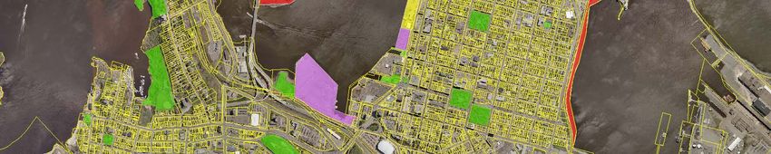
This plan was prepared by exp for the account of the Saint John Port Authority.

 Any use which a third party makes of this report, or any reliance on or decisions to be
made based on it, are the responsibility of such third parties. Exp and the Saint John Port
 Authority accepts no responsibility for damages, if any, suffered by any third party as a
               result of decisions made or actions based on this project.

           This report has been prepared by exp, Saint John, New Brunswick
                                      June 2011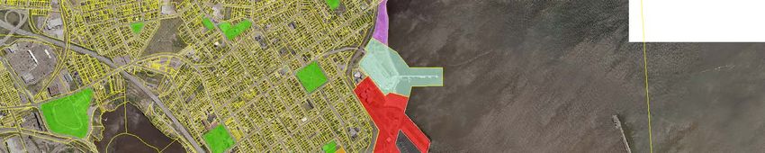
Executive Summary
The Port of Saint John is New Brunswick’s largest and most diverse port and its only container port. It primarily
handles bulk and break-bulk cargo, is well-suited for niche container markets and is a major port-of-call in
Canada-New England for cruise ships.

The Port’s major commodities are petroleum products and LNG, potash and salt, recyclable metal, containers,
other bulk cargo, forest products and project cargo. In addition, the Port has been very successful in building its
cruise sector and has become the fourth largest cruise port in Canada.

The SJPA is one of seventeen Canada Port Authorities established under the 1998 Canada Marine Act. Its mission
is to facilitate maritime trade and maximize the use of Port assets by providing facilities, services and business
development expertise for customers and stakeholders.

The purpose of the Port Authority’s Land Use Plan is to serve as a guiding document for the ongoing
development and utilization of Port lands. The SJPA deals with strategic land management issues in a manner
specific to local circumstances. The very existence of a port requires adequate facilities for the handling, storage
and transfer of cargo and the safe and efficient transfer of passengers; private commercial and industrial sites
also exist along the waterfront, as does the provision for public access.

In carrying out the revision of its land use plan, the Port Authority engaged ADI Consulting (now exp) to assist
in its development and provided for significant stakeholder and public input. In doing so, the Port Authority
followed a more in-depth consultation process than required by legislation. This process included consultations
with port stakeholders, the Municipality and appropriate Committees and the business sector. In addition, the
process allowed for public input through a sixty day period, during which time two public forums were held.
This allowed the Authority to explain the proposed land use plan and gain an understanding of the various
perspectives from port and community stakeholders.

The geography of the Port of Saint John provides only a limited land base. Therefore, the SJPA must endeavour
to effectively protect and manage its land and water resources to accommodate the long term needs of port
operations and the industry. It is essential the SJPA optimize land utilization in order to capture economic
benefits, manage its land resources and strengthen Saint John as a gateway for trade.

The SJPA has developed land use policy directions for the Port of Saint John to enable its customers,
stakeholders, municipal neighbours, government agencies and the public to identify and understand the
principles by which it intends to manage its federal land assets.

The primary use of port lands is for the assembly, storage and handling of marine cargo and passengers and to
be the transfer point between ship and shore. Paramount for the Port Authority is the preservation of its land
holdings for these purposes.

Following stakeholder and public input, the Land Use Plan was finalized and approved by the Board of Directors.
A summary of the highlights are listed below:

•   The West Side port, Lower Cove and Barrack Point Potash Terminal will continue to be used as the port’s
    major active cargo areas;

•   The Lower West Side will be reserved for redevelopment use as a marine terminal, port industrial activity and
    with the cooperation of the Department of Fisheries, the provision of a small craft facility as proposed by
    Saint John Harbour Fishermens Association will be provided at Pier 14;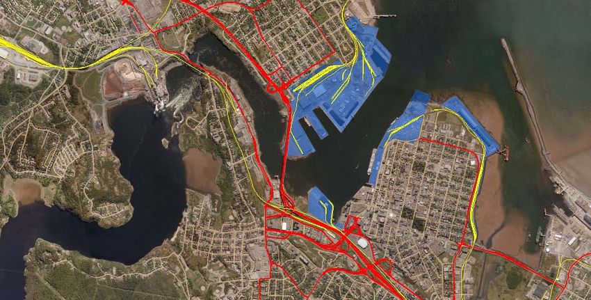
•   Cruise Operations will be concentrated on the East side of the Main Harbour at the Marco Polo Cruise
    Terminal, Pugsley C and Long Wharf;

•   Long Wharf is considered as a strategic development parcel and the Port Authority will undertake
    development of a Master Plan for its future use, which will consider port-related activities interfacing with
    innovative approaches consistent with the SJPA Business strategies and alignment with Plan SJ outcomes
    to the degree possible. Until then, Long Wharf will continue to be used for cruise-related activities, clean
    cargoes and the interim use for fishing operations;

•   The Port Authority has also identified the area known as Pugsley Park as an area for non-traditional
    development which will complement cruise-related activity, tourism activity and public access to the
    waterfront;

•   Courtenay Bay will continue to be used for dry and liquid bulk cargoes. The storage and movement of potash
    is an important contributor to the longevity and financial sustainability of the Port. Expansion of the terminal
    may be required in the long-term and must be taken into consideration in this land use plan;

•   The SJPA will implement an Asset Life Cycle Plan to address the major maintenance and renewal
    requirements of its assets over the coming months and years. In the long term and within its own strategic
    objectives, the SJPA will encourage development of new replacement facilities on identified sites and
    consider alternate port and marine-related use of those sites which will energize the public waterfront;

•   The Port Authority will consider how best to create buffers or transitional zones between port activity and
    the neighbouring communities along Market Place on the West Side and in the area along Broad Street at
    Lower Cove terminal. These may take the form of natural buffers, walkways or development of light industrial
    or commercial businesses;

•   Taking into consideration established activities in adjacent areas and to ensure quality, the SJPA will
    seek adherence to certain design principles that promote quality and sustainable development, thereby
    contributing to overall quality of development and stimulating private investment that meets public
    objectives;

•   The “experience” of the commercial waterfront character and industrial heritage of the Inner Harbour is
    enhanced by the presence of the working port. The SJPA will continue to work with the local community
    to enhance the port/public waterfront in a manner that is safe and compatible with port operations while
    considering current and future Port and community needs;

•   The City of Saint John is currently reviewing and preparing a new Municipal Plan.The SJPA is committed to
    working with the City of Saint John and other land use stakeholders on matters of mutual interest, including
    land use issues, promotion of Port business, retention of industrial lands, the safe and efficient movement of
    passengers and cargo through the Port of Saint John and enhancement of the environment;

•   The Port Authority recognizes that industrial manufacturing and distribution projects that have large acreage
    requirements can be better accommodated within the existing industrial land supply provided by Municipal
    and Provincial land supply agencies. Together with Municipal and Provincial partners, the Port Authority
    will continue to support and respond to the needs of the business community and seek ways to develop
    synergies between the port and the Industrial Parks, while advancing its mandate to provide the marine
    transportation infrastructure for our Region;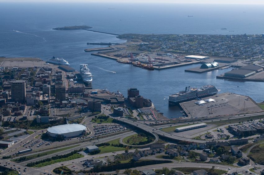
•   In this Land Use Plan, Saint John Port Authority identifies a number of land parcels contiguous to port
    property which, if they became available, would be of interest to the Port Authority for the long-term
    development. These include Federal Lands at the Ferry Terminal and in the South End under Department of
    National Defense, the Sugar Refinery Site and the former site of Imperial Oil Tank Farm adjacent to potash
    terminal.

This Land Use Plan charts the future direction of the SJPA over the next 10 to 15 years. It establishes the basis
for decision making for the future development and use of lands and provides the necessary direction needed
to manage the Port of Saint John in support of Canada’s international trade and strategic development for the
future, as well as short term uses for non-marine trade. It also allows for the complementary development of the
waterfront for public access and municipal development.

This Port Land Use Plan reflects SJPA’s commitment to direct and manage the long term planning and
development of its land and water resources.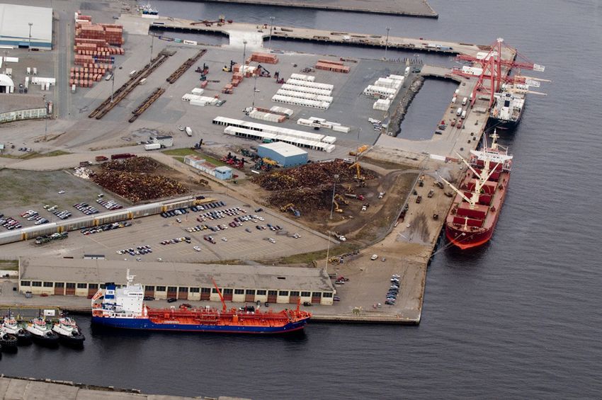
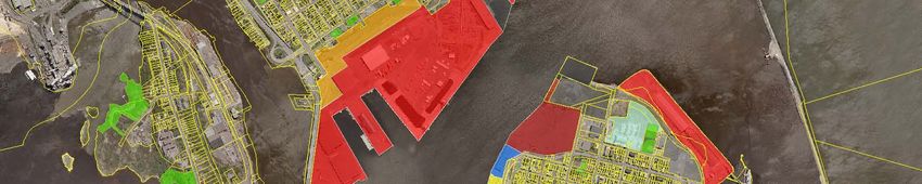
Table of Contents
Executive Summary
Foreword 1
1.0 The Port of Saint John 2
1.1 The Port 2
Description of Characteristics 2
Harbour Limits 2
Saint John Port Authority Facilities 4
Saint John Port Authority Water Lots 4
1.2 Saint John Port Authority 5
Governing Legislation and Mandate 5
Environmental Considerations 6
Marine Security 6
Legislative Framework for the Land Use Plan 7
Purpose of the Land Use Plan 7
1.3 Port Planning Context 7
1.4 SJPA Land Use Policy 8
Land Management 8
Land Use Plan Process 8
Stakeholder Consultation 8
Public Review Period 9
2.0 Business Environment 10
Petroleum Products & LNG 10
Potash & Salt 10
Other Bulk 11
Containers 11
Break Bulk Cargo & Forest Products 11
Passenger and Cruise Ship Traffic 11
Other Activities 12
Business Environment Summary 12
Port Economic Impact 12
3.0 Port Facilities 13
Upper West Side 14
Lower West Side 15
Inner Harbour 17
Courtenay Bay 18
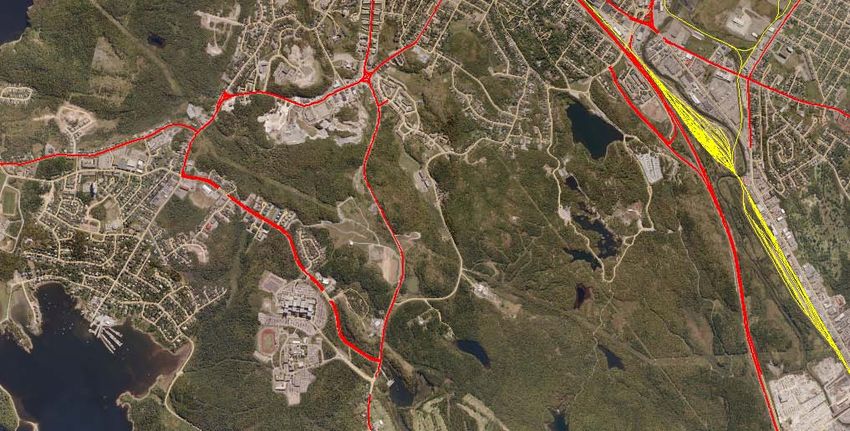
Road and Rail Access 19
4.0 Community Interface 24
Municipal Plan & Zoning 24
Saint John Inner Harbour Land Use Plan 24
Port/Public Interface 25
5.0 Land Use Policy Directions 26
General Land Use 26
Cargo Sectors 26
Cruise Sector 26
Marine Service and Marine Uses 26
Port Land Buffers 27
Port/Public Waterfront Interface 27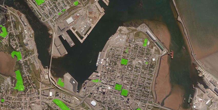
6.0     Planning Areas & Future Land Use Designations       29
        Upper West Side (Navy Island - Rodney Terminal)     29
        Lower West Side (Piers 10, 11, 12)                  33
        Long Wharf Main Harbour                             34
        Marco Polo Cruise Terminal, Pugsley C Terminal
                & Pugsley Parking Lot                       35
        Lower Cove Terminal                                 35
        Barrack Point Potash Terminal at Courtenay Bay      37
        Lands of Interest                                   37
        Areas for Possible Expansion                        37
        General Land Use Directions                         38
7.0     Implementation                                      39
        Project Review Process                              39
        Monitoring the Plan                                 39
        Implementation Strategy                             39
8.0     Summary                                             40

        Glossary

        Appendix A: Canada Marine Act
        Appendix B: Saint John Port Authority Letters Patent
        Appendix C: SJPA Facilities Plan
        Appendix D: SJPA Land Use Factors & Guidelines
        Appendix E: Stakeholder Input
        Appendix F: Historical Background of the Port of Saint
                       John

List of Maps

Map 1: Saint John Port Authority Harbour Limits             3
Map 2: Saint John Port Authority Transportation Access      20
Map 3: Public Park Lands & Waterfront Access                28
Map 4: Saint John Port Land Use Plan                        31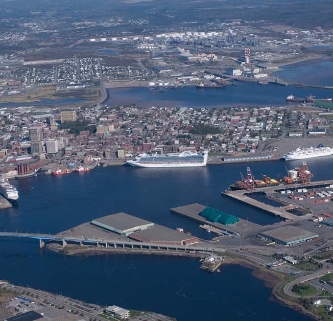
Foreword
In keeping with the legislative requirements of the
Canada Marine Act, the Saint John Port Authority
(herein after referred to as the SJPA) developed and
released its first Land Use Plan in 2000, which outlined
its land holdings and their uses and identified future
requirements necessary to allow the Port Authority
to meet its mandate as a national port in support-
ing Canada’s domestic and international waterborne
trade. Since then, there have been a number of
significant changes in the Port of Saint John’s (the
Port) land use, cargo mix and volumes and the
emergence of cruise as a major marine business sector
for the Port. Given these factors, the Port Authority
has determined this to be an opportune time to re-
assess its land use requirements and revise its Land
Use Plan. As it did previously, the Port Authority
consulted with its stakeholders, business leaders and
the community and held public meetings to gain their
views and input into the Plan. The initiative was also
considered timely as the City of Saint John was
preparing a new Municipal Plan to be released in 2012.
As a result, this revised Land Use Plan will outline the
present and future needs of the Port and the
projected land use requirements.

       The Port of Saint John

                                                           2011 Land Use Plan   1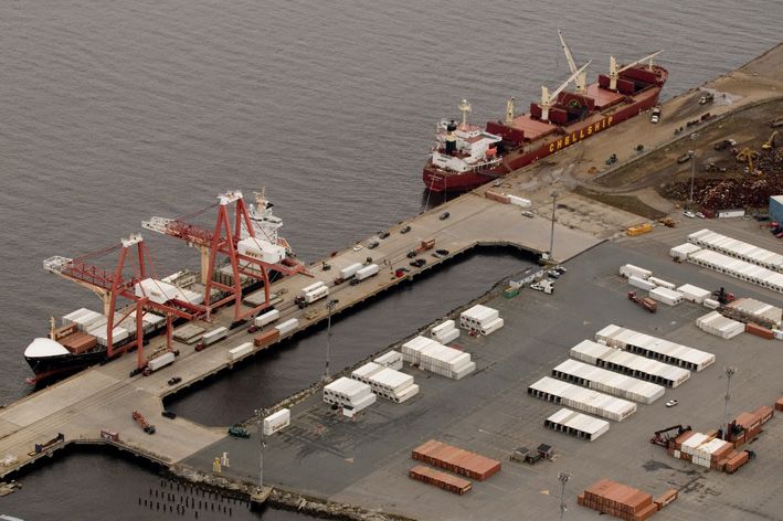
1.0 The Port of Saint John

1.1 The Port
Description and Characteristics                                Harbour Limits
Located on the Bay of Fundy at the mouth of the St.            The legally defined portion of the Saint John Harbour
John River, the Port of Saint John is a recognized port        under the jurisdiction of the SJPA was established by
of national significance and one of Canada’s marine            PC 1977 - 2115, 21 July 1977. The southerly limit runs
gateways for domestic and international trade and              due east from Musquash Harbour to south of Cape
tourism.                                                       Spencer. The northerly limit is at Randolph, near
                                                               Dominion Park.
It has a wide range of facilities to handle all types of
cargo and is essential to some of the Province’s major         The Port experiences some of the highest tides in the
industries. Its diversified operations cross six business      world with tidal ranges fluctuating between 6.0 to
sectors: liquid bulk, dry bulk, break bulk, containers,        8.5 metres. The combination of these tides and the
cruise and indirect marine-related activities.                 outflow of the St. John River result in strong currents
                                                               flowing though the harbour which complicates the
The SJPA has jurisdiction over the navigable water             movement of shipping in and out of the harbor for the
contained within the Harbour Limits (See Map 1).               marine pilots. Pilotage in the Port is compulsory and
However its land holdings are contained within the             managed by the Atlantic Pilotage Authority.
Inner Harbour (See Fig. 1).

                Figure 1: Property Under the Management & Control of the SJPA

                Source: Saint John Port Authority Website (www.sjport.com)

2       Saint John Port Authority
2516000.000000 2522000.000000 2528000.000000 2534000.000000 2540000.000000 2546000.000000
Saint John
Map 1:Port
Saint Authority
John Port Authority - Harbour
ProjectHarbour LimitsLimits
Map 1: Saint John Port Authority Harbour Limits
³
7370000.000000
7370000.000000
Green Head
7365000.000000
7365000.000000
Main Harbour
7360000.000000
7360000.000000
Cape Spencer
Canaport
Five Fathom Hole Manawagonish Canaport LNG
45 11' 09"N Island
66 15' 33"W
7355000.000000
7355000.000000
Mooring Buoy
Saint John Harbour Limits
7350000.000000
7350000.000000
(Regulatory Limits)
45 08' 03"N 45 08' 03"N
66 17' 12" W 0 1 2 4 6 65 54' 37" W
Kilometers
2516000.000000 2522000.000000 2528000.000000 2534000.000000 2540000.000000 2546000.000000The Harbour consists of three key areas: Saint John Port Authority Facilities
A. The Outer Harbour SJPA facilities and property consist of:
The portion of the Bay of Fundy between
Partridge Island and a line running east from West Side: Navy Island Forest Terminal
Musquash Harbour to due south of Cape Rodney Container Terminal
Spencer. It contains the crude oil reception Terminal 12
facility at Canaport, Mispec Point LNG Terminal Lower West Side
and the Port’s designated anchorages and
pilot boarding station. East Side: Long Wharf
Marco Polo Cruise Terminal
B. The Main Harbour Pugsley C
Located between the Central Peninsula and Lower Cove
the West Side, it contains the majority of Wharf at the former Lantic
SJPA’s facilities. The location of these facilities Sugar Refinery Site
is listed below. The Canadian Coast Guard
Base and a public waterfront area at Market Courtenay Bay: Barrack Point Potash Terminal
Slip with hotel residential complexes,
restaurants and public boat landing are Private Facilities: Canaport crude oil facility
located in the north-east corner of the Main (Outer Harbour)
Harbour. The former Lantic Sugar site lies Mispec Point LNG Terminal
immediately south of Lower Cove on the East (Outer Harbour)
side and is owned by the City of Saint John, Irving Oil Terminals
with the wharf area being owned by the SJPA. (Courtenay Bay)
Atlantic Wallboard Plant -
Access is through the main navigation channel previously Saint John Ship
running north-west/south-east to the east of Building & Drydock
Partridge Island. The St. John River enters the (Courtenay Bay)
Bay of Fundy through this main harbour. Bay Ferries Terminal
(Lower West Side)
C. Courtenay Bay
Lies east of the Central Peninsula and is Saint John Port Authority Water Lots
accessed via Courtenay Bay navigation
channel. The Irving Oil terminal, the Atlantic The harbour bottom within Partridge Island and
Wallboard manufacturing plant (previously Courtenay Bay breakwaters up to the Reversing Falls
Saint John Shipbuilding & Drydock) and Bridge is owned by the Federal Crown and managed
Barrack Point Potash Terminal are located in by the SJPA and as such the Port Authority leases out
Courtenay Bay. individual water lots within this area.
4 Saint John Port Authority1.2 Saint John Port Authority • Provide for a high level of safety and
environmental protection;
The SJPA is one of seventeen Canada Port • Provide a high degree of autonomy for local
Authorities established under the 1998 Canada Marine or regional management of components of
Act (Appendix A). Its mission is to facilitate maritime the system of services and facilities and be
trade and maximize the use of Port assets by responsive to local needs and priorities;
providing facilities, services and business • Manage the marine infrastructure and services
development expertise for customers and stake- in a commercial manner that encourages and
holders. In so doing, it will ensure a thriving long-term takes into account input from users and the
port. community in which a port or harbour is
located;
Paramount for the Port Authority is to ensure it has • Provide for the disposition, by transfer or
sufficient facilities and flexibility in its land holdings otherwise, of certain ports and port facilities;
to accommodate the efficient and timely transfer of and
cargo and passengers between ship and shore, • Promote coordination and integration of
providing a global portal for Canada’s imports and marine activities with surface and air
exports. transportation systems.
Each Canada Port Authority is established by
Governing Legislation and Mandate individual letters patent. Letters Patent issued on May
1, 1999, established the SJPA as a Canada Port
The governing legislation for all port authorities is Authority, a continuation from the Saint John Port
the Canada Marine Act that implemented the federal Corporation.
government’s National Marine Policy and called for
the modernization of the marine management and As part of its responsibility, the SJPA is charged with
regulatory regime by introducing business disciplines managing federal real property as described in its
to achieve greater efficiency in the marine Letters Patent (Appendix B). The Port Authority
transportation sector. It constituted and allowed for operates as a financially self-sufficient agent of the
the establishment of Canada Port Authorities (CPA). In Federal Crown. In general, port authorities or any
recognition of the significance of marine subsidiaries cannot access federal government funds
transportation to Canada and its contribution to the except in certain circumstances. Section 25 of the Act
Canadian economy, the purpose of the Act is to: states that no payment can be made to a port
authority or any subsidiary under an appropriation by
• Implement marine policies that provide Parliament to enable it to discharge an obligation or
Canada with needed marine infrastructure, liability unless the payment:
offers effective support for the achievement of
national, regional and local social and • Is made under the Emergencies Act or any
economic objectives and promotes and safe- other Act in respect of emergencies;
guards Canada’s competitiveness and trade • Is a contribution in respect of the capital costs
objectives; of an infrastructure project;
• Promote the success of ports for the purpose • Is a contribution in respect of environmental
of contributing to the competitiveness, sustainability; or
growth and prosperity of the Canadian • Is a contribution in respect of security.
economy;
• Base the marine infrastructure and services on Port authorities are required to pay an annual stipend
international practices and approaches that based on their gross revenues to the Federal Minister
are consistent with those of Canada’s trading of Transport for the use of Crown lands. They also
partners in order to foster harmonization of make payments in lieu of taxes (PILTS) and their
standards among jurisdictions; tenants pay property taxes.
• Ensure that marine transportation services
are organized to satisfy the needs of users and A Canada Port Authority manages the lands upon
are available at a reasonable cost; which it operates however it cannot pledge them
for collateral. Furthermore, should a Port Authority
2011 Land Use Plan 5wish to sell any of these lands, it would be required to Under CEAA, a project is defined as:
declare the lands surplus to its needs and would not
be permitted to retain the proceeds. Thus, the SJPA • In relation to any physical work, any proposed
operates entirely from its own resources, deriving its construction, operation, modification,
revenues solely from port fees, leases and investment decommissioning, abandonment or other
income all of which pay for operational expenses and undertaking in relation to the physical work;
contribute towards capital expansion projects under- or
taken. Profits are reinvested in the Port of Saint John • Any proposed physical activity not relating to
to ensure an efficient and competitive environment a physical work that is prescribed or within a
for Canada’s domestic and international waterborne class of physical activities that is prescribed
trade. pursuant to the regulations.
The SJPA is also subject to other Federal legislation, The Canada Port Authority Environmental Assessment
the most relevant to land use being the Canadian Regulations place the responsibility of overseeing
Environmental Assessment Act and Regulations and the the assessment on the SJPA, which when applicable
Marine Transportation Security Act and Regulations. would require the proponent to carry out any
necessary studies or surveys (including seeking public
comment where it is deemed warranted) that may be
Environmental Considerations required to complete the assessment.
All Canada Port Authorities are subject to the
In fulfilling its environmental responsibility, the SJPA
Canadian Environmental Assessment Act (CEAA) and its
works collaboratively in a multi-agency development
regulations and in particular the Canada Port Author-
review process to carefully control and evaluate the
ity Environmental Assessment Regulations. Where
environmental impacts of the port’s activities. This
a proponent other than the Port Authority wishes
includes but is not limited to Environment Canada,
to carry out a project on port lands, the SJPA is the
Transport Canada, the Department of Fisheries and
responsible authority for ensuring the appropriate
Oceans and the Canadian Environmental Assessment
environmental assessment is carried out for the
Agency. Applicable environmental legislation and best
project and for approving the assessment of the
management practices are considered during SJPA’s
project. Where the SJPA is the proponent for a project,
development review of new projects and as part of its
it would be required to meet the appropriate
overall stewardship responsibilities.
environmental assessment and require the approval of
the Canadian Environmental Agency and other federal
Respecting that the environment is one of the SJPA’s
departments.
core values, it recognizes that quality of life and the
environment are interrelated. The Port Authority’s
In general, the Act applies when a federal department
Land Use Plan supports planning and development
or agency exercises one or more of the following
activities in cooperation with its tenants, operators,
powers, duties or functions in relation to a project. An
the municipality and other government agencies and
EA under the Act is triggered when a Federal Authority
regulators to improving the standards of
is:
environmental protection of the harbour.
• The proponent of a project;
In the interest of responsibly managing the resources
• Proposing to sell, lease or otherwise transfer
under its jurisdiction, the SJPA endeavours to balance
control or administration of land to enable a
customer demands with those for sustainable
project to be carried out;
development and competing demands for waterfront
• Contributing money or another form of
land use. Accordingly, the SJPA is committed to
financial assistance to the project; and
processes that enable it to meet this challenge
• Exercising a regulatory duty in relation to the
proactively; a challenge made more difficult and the
project by issuing a permit, license,
responsible management of which is made more
authorization or approval that is included in
essential, given that the Port of Saint John is bordered
the Law List Regulations.
by some of the most desirable real estate in the City.
6 Saint John Port AuthorityMarine Security • Help strengthen land use coordination
between SJPA and neighbouring
Marine security has become a high priority for all communities, other port stakeholders and
ports and the marine industry, not only in Canada but governments.
internationally. In considering its land use and the
operation of its marine facilities, the Port Authority
is required to follow the requirements of the Marine
1.3 The Port Planning Context
Transportation Act and Regulations, both of which are The viability of Saint John’s Port and its capability to
linked to the International Ships and Port Facility generate economic activity depends on its ability to
Security Code established by the International respond to local, national and global market
Maritime Organization (IMO) following the events of opportunities and conditions. The SJPA Land Use Plan
9/11. This requires strict access controls at port has been developed within this context and
facilities and restricts access to those employed at recognizes the challenging and competitive
facilities and those conducting business at the port. It environment in which the Port of Saint John operates.
includes registration of personnel, issuance of
identification cards and in certain cases the provision The SJPA Land Use Plan acknowledges that:
of a Transport Canada Clearance. It is anticipated that
security controls will continue to evolve given the • The port is a major economic asset to the
ongoing perimeter security discussions between economy of the Province of New Brunswick
Canada and the United States. and the Saint John Region;
• SJPA is a self-financing port authority that
Legislative Framework for the Land Use Plan operates in a highly competitive environment
with other ports in North America;
The Canada Marine Act, Section 48, requires that each • The port has a limited land base that must be
Canadian Port Authority adopt a comprehensive Port managed to accommodate the long-term
Land Use Plan (Appendix A-4). The Saint John Port needs of the port industry;
Authority Land Use Plan must include the Port’s land • Many of the port’s businesses are heavy
use objectives and policy directions under which it will industrial operations and therefore have
make its development decisions. This Land Use Plan, specific land and infrastructure needs;
therefore, fulfils these requirements for the SJPA. • The viability of the port depends on an
effective and efficient road and rail network
for the movement of goods and cargo
Purpose of the Land Use Plan between the port and its markets;
• International requirements for safety and
The purpose of the Port Authority’s Land Use Plan is to
security in and around the port will continue
serve as a guiding document for the ongoing develop-
to be reinforced to ensure that port operations
ment and utilization of Port lands. The objectives of
meet trade import and export requirements;
the Plan are to:
• Public benefits must be balanced with the
operational realities of a working port; and
• Communicate SJPA’s long term land use policy
• Working with community and business stake-
directions and initiatives;
holders is critical to long term sustainability of
• Illustrate the Port’s ability to accommodate
the Port given the physical constraints of
future growth in an economic, environmental
operating in a small harbour surrounded by a
and socially responsible manner;
wide variety of land uses.
• Use policy directions to link optimal land
utilization with future growth opportunities;
• Identify the significance of the regional and
national transportation networks to the
ongoing and future success of the Port of
Saint John; and
2011 Land Use Plan 71.4 SJPA Land Use Policy Authority website for a public review period. Notices
to this effect appeared in the local newspaper advising
of the availability of the draft plan and the date and
Land Management time for public meetings.
Canadian ports, while serving a common function, are
unique in their land issues and require an individual Stakeholder Consultation
response and approach. The SJPA therefore deals with
strategic land management issues in a manner specific The Canada Marine Act allows for a Port Authority
to local circumstances. The very existence of a port to engage in a consultation process, the purpose of
requires adequate facilities for the handling, storage which is to create a successful land use plan that
and transfer of cargo and the safe and efficient addresses land use needs of a port in the conduct
transfer of passengers; private commercial and of its business both for the short and long term and,
industrial sites also exist along the waterfront, as does where possible, integrates a port’s objectives with
the provision for public access. those of the community in such a way that ensures a
port’s continued growth and sustainability.
The SJPA follows a business development approach in
determining the most appropriate uses of Port lands. Sharing an urban environment with a wide variety of
Key to this approach is the understanding that the land users, each with their own intent may cause
Port is contained within the surrounding urban area conflict. The SJPA realizes the opportunity and the
and that there is a limited quantity of waterfront responsibility to engage the community in this land
property suitable for development of marine use planning process and resolved to carry out
terminals. consultations on a broad level. Through consultation,
the SJPA, its stakeholders and the public can better
The SJPA continually faces the challenge stemming appreciate both parallel and opposing opinions, new
from competing interests for a finite amount of ideas and progressive suggestions. Stakeholder
available urban waterfront land. Pressures for consultations occurred either on a one-on-one or
waterfront development and access have intensified focus group basis with others providing written feed-
in Saint John, as elsewhere, and the SJPA must back via a questionnaire.
consider how to best respond and mitigate land use
conflicts through the updating of its Land Use Plan. The SJPA identified 45 stakeholders within 5 groups
The Canada Marine Act identifies the need for port representing various Port, business and municipal
authorities to take into consideration surrounding aspects including the key Port users, the cruise
land uses in their land use planning and provide industry, business organizations and the City of Saint
opportunity for the public to participate. John Planning and Development Department. These
were categorized in five groups:
The nature of a Land Use Plan is dynamic and what
may be applicable today may not be to future • Group A - Port Users and Leaseholders
circumstances. Thus, responding to business, environ- • Group B - Cruise Operators
mental, economic, and social and community issues • Group C - Other Port Stakeholders – agents,
requires a regular monitor-and-respond approach to marine consultants etc.
keep the SJPA Land Use Plan relevant. • Group D - City of Saint John Planning &
Development Department
• Group E - Business Community
Land Use Plan Process
In carrying out the revision of its Land Use Plan, the
Port Authority engaged ADI consultants to assist in
the process. This commenced with the development
of a first draft following stakeholder consultations.
This first draft was reviewed by the SJPA Board of
Directors who provided comment. It was then made
available to the public and posted to the Port
8 Saint John Port AuthorityFinal participation and feedback included: • Port Users;
• Cruise Industry;
• Group A 6 of 15 Invitees • Other Port Interests;
• Group B 4 of 4 Invitees • City of Saint John, Planning & Development;
• Group C 4 of 19 Invitees • Saint John Business Community: Enterprise
• Group D Commissioner and Saint John, Saint John Airport, SJ Board of
Deputy Commissioner, Trade, SJ Development Corporation, and
Planning & Development, Uptown Saint John.
City of Saint John
• Group E 5 of 5 Invitees The issues that arose during the consultation process
were summarized and presented to the Saint John
An additional 15 stakeholders completed and Port Authority in the January 28th report titled
returned the questionnaire in lieu of an interview or Summary of Land Use Issues, which was reviewed by
focus group participation. The summary of the Port Authority and given consideration for
stakeholder feedback is found in Appendix E. inclusion in the draft Land Use Plan:
• Role of the Port;
Public Review Period • Land Use Efficiency;
• Future Land Use;
The Saint John Port Authority expressed its commit-
ment to a thorough public consultation process in
• State of Infrastructure; and
updating its Land Use Plan and directed a process
• Urban Interface.
that included a strategy of focus groups, stakeholder
The draft Land Use Plan was made available to the
and public consultations and port-user interviews. A
public and posted to the Port Authority website to
consultation process was initiated to seek firsthand
initiate the regulated 60-Day Public Review Period on
knowledge and gain an understanding of the various
March 21st, 2011. During this time, the Saint John Port
perspectives from port and community stake-
Authority held two public meetings: March 29th at the
holders. The Saint John Port Authority provided a list
Marco Polo Cruise Terminal, representing the east side
of stakeholders representing a total of 45 businesses
community, and April 19th, 2011 at the Carleton Kirk
and organizations as well as five community sectors
Church, representing the west side community. The
and a series of interviews and focus groups were held
feedback and input received was considered by the
in January 2011:
Saint John Port Authority and adjustments
incorporated into the final Land Use Plan.
Metal Shredding on the West Side
2011 Land Use Plan 92.0 Business Environment 2010, the Port of Saint John handled over 30 million
tonnes of cargo. Through changes in trading patterns,
the development of containerization and economic
Today’s commerce operates within a competitive
downturns, the Port has faced a number of challenges
global environment. Canada’s economy depends on
in attempting to transition from traditional business
international trade and on the efficient movement of
and growing its container and break bulk sectors.
goods within the international and domestic
Therefore, it has focused on diversifying its activities
marketplace facilitated by multimodal transportation
and operations and pursuing new opportunities to
networks. Marine transportation plays a critical role
promote growth and increasing port traffic.
and is therefore a major contributor to the national
economy. Ports are essential to the transportation
The Port has a wide range of facilities to handle all
chain connecting marine to road and rail
types of cargo and is essential to some of the
transportation systems. The Port of Saint John is one
Province’s major industries. The SJPA operates
of these international gateways.
primarily as a landlord Port, leasing out key facilities to
operators for the purposes of attracting and handling
The degree to which the Port of Saint John can
goods and passengers in support of Canada’s water-
better support the transportation requirements of
borne trade and national economy. The Port’s major
businesses embedded in the local and regional
commodities are petroleum products and LNG, potash
economy represents an excellent opportunity for
and salt, recyclable metal, containers, other bulk
growth. The Port Authority recognizes that industrial
cargo, forest products and project cargo. In addition,
manufacturing and distribution projects that have
the Port has been very successful in establishing itself
large acreage requirements can be better accom-
as a major port-of-call in Canada-New England for
modated within the existing industrial land supply
cruise ships and has become the fourth largest cruise
provided by Municipal and Provincial land supply
port in Canada.
agencies. There are a number of industrial parks
located around the City which could benefit from the
port. Together with Municipal and Provincial partners, Petroleum Products & LNG
the Port will continue to support and respond to the
needs of the business community while advancing its The largest volume of cargo at the Port is petroleum
mandate to provide the marine transportation infra- and LNG which are handled at private facilities and
structure for our Region. which only generate revenue for the Port
Authority from the vessels through the harbour dues
The Port of Saint John is New Brunswick’s largest and tariff. Volumes are in the region of 27 million tonnes
most diverse port and its only container port. It per year and are expected to be maintained or
primarily handles bulk and break-bulk cargo, is well- increased in the future. This includes the potential of
suited for niche container markets and is a major developing additional marine facilities in the Outer
port-of-call for cruise ships. It is a key player in Harbour.
moving goods and resources worldwide. A significant
volume of cargo originates from or is imported to New
Brunswick and is associated with local industry. In
Figure 2: Cargo Traffic - Total Port Freight Volumes (million metric tonnes)
Source: Saint John Port Authority
Notes: Liquid bulk includes petroleum, LNG, chemicals, molasses, fish oil. Dry bulk includes potash, salt, recyclable metals,
sugar, limestone, fish meal. General includes forest products, project cargo, steel, vehicles. TEU – 20 foot container
equivalent unit
10 Saint John Port AuthorityPotash & Salt to support the increased size and capacity of
container ships engaged in main line services. Its
Potash and salt represent the highest volume of cargo strength lies in servicing niche market and small to
handled at Port Authority facilities and is the greatest medium sized ships. The Port must address the
generator of revenue. Normal volumes are around challenges of securing long term operators,
1 million tonnes per year. The Sussex potash mine equipment replacement and having a competitive
expansion under way is projected to increase volumes rail service model to move containers to and from
to 2 million tonnes per year or more within the next inland destinations. The Port presently handles 45,000
five years. -50,000 TEUs (twenty foot equivalent units) per year.
Capacity of the terminal is in the area of 150,000 TEUs
and a second container line at this terminal would
Other Bulk bring it close to capacity.
Recyclable metal is becoming a significant component
of Port business, diversifying operations and Break Bulk Cargo & Forest Products
resulting in an expansion of the facility at Terminal 12.
This operation includes a metal-shredding Break bulk cargo is becoming more limited as a
facility and the exporting of material and heavy scrap consequence of increased containerised cargo and
which constitutes the cargo. The proponent is a downturn in the North American forest products
investing significant monies into the infrastructure industry. Project cargo has increased in recent years
and will bring a much-needed activity at the Port, and has the potential of providing further
increased man-hours for labour, increased shipping opportunities in the future.
and cargo volumes and new long term jobs in the
community. While the 2009 recession caused a downturn in a
number of sectors at the Port, a decline of forest
Fish oil and molasses (liquid bulk) are also imported products shipments is by far the most significant for
at Terminal 12 and pumped to the tank farm in the the Port Authority. Cargo tonnage in this sector has
Lower West Side Port area. This business is steady with dropped from one million tonnes in 1996 to an
modest annual tonnages, generating approximately average of 500,000 tonnes per year from 2000-2004 to
six (6) vessels per year. under 100,000 tonnes in 2010. The primary cause of
this has been the closure of paper mills in New
Petroleum coke is imported through facilities at the Brunswick, Canada and the U.S. and the migration of
Navy Island Terminal. available forest products exports to the main line
container services that fill otherwise empty containers
The Port Authority is also exploring other being repositioned offshore for reloading of imports
opportunities in dry bulk which may lead to further to Canada.
investment in Port facilities.
Passenger and Cruise Ship Traffic
Containers
Cruise ship business has grown significantly in recent
Much of today’s consumer and manufactured goods years. The port has the capacity to handle the
move in containers. The Port is not strategically largest cruise ships, such as the Queen Mary 2, on the
located in the trade patterns of most global carriers
nor has it the necessary water depth or infrastructure
Figure 3: Port of Saint John Cruise Ship Traffic
Source: Saint John Port Authority website www.sjport.com February 22, 2011*forecast
2011 Land Use Plan 11eastern side of the Main Harbour at the Marco Polo business plans and strategies. This requires
Cruise Terminal. Available also are Long Wharf and careful analysis of land requirements and
Pugsley C, allowing for docking of three cruise ships at planning of land uses to which the strategic
the same time. The Port Authority is in the process of business objectives set by the SJPA can be
expanding its cruise berthing capacity and linked;
infrastructure at Pugsley C and at Long Wharf to
accommodate multiple same-day calls of the larger • As a Canada Port Authority, the SJPA is
and longer ships now entering service. In 2009, 84% required by legislation to provide and manage
of cruise vessels calling at the port were in excess of its facilities to support trade and the activities
290m in length and in 2010, 89% of cruise vessels in which it may engage, which are specified in
were in excess of 290m in length, demonstrating the its Letters Patent. (See Appendix B); and
trend to larger vessels. The cruise sector has grown
exponentially from an average of 50,000 passengers • The SJPA is working to attract new business to
per season to over 200,000 passengers per season the Port. It has projected growth in bulk,
with further growth projected. The objective of the break bulk cargo, cruise and containers and is
Port Authority is to attain 300,000 passengers by 2015. examining industry forecasts and the impact
of global economics through its strategic
planning process. Through plans for
Other Activities diversification, business development and
infrastructure investments, the SJPA will be
Global economic factors, increased competition and
able to allocate and organize lands and uses
efficiency improvements along with a declining forest
in a way that signifies the need for its current
products sector have impacted activity levels at the
holdings and support future expansion plans.
Port of Saint John. Acknowledging the shift in
business and its necessity to respond to a new
business environment, the SJPA has encouraged
continued diversification of its activities linked with
Port Economic Impact
its business sectors. Examples of this are the Floating
Canada’s 17 different Port Authorities collectively
Pipeline Company fabrication plant in Shed D and the
handle 460 million tonnes of cargo per year, valued
auto distribution centre at Navy Island Terminal and
at over $162 billion generating 250,000 direct and
retail outlets in the form of the Dockside Market
indirect jobs and $10.2 billion in salaries nation-wide.
associated with the cruise sector.
Canadian ports contribute $30 billion to Canada’s GDP
with $2.2 billion paid in federal and provincial income
taxes and $2 billion paid in consumption tax (Source:
Business Environment Summary Association of Canada Port Authorities). Forty per cent
(40%) of Canada’s GDP is dependent on trade with
• The SJPA foresees new opportunities that
over 160 countries worldwide. Bulk cargo volumes
require significant capital investment to
make up the vast majority of Canada’s throughput
upgrade infrastructure so that it can
and are considered as the foundation to maintaining
aggressively compete within an ever changing
traditional tonnage and traffic.
global trade network;
By facilitating trade, the SJPA contributes to the
• SJPA must be cost-effective and competitive.
national, regional and local economies. As a “gateway”
Therefore, it must seek to maximize the use
to international markets, the Port supports economic
of its lands and facilities to ensure operations
and employment growth among producers,
and land availability meet the demands of
shippers, wholesalers, unions, retailers and many other
the trade. Maintaining the current infra-
marine-related industries and services. In addition,
structure and advancing technology and
the economic impact is multiplied through indirect
operations to respond to the marine
and induced economic activity. As such, the Port plays
transportation industry and capture future
a significant role in the various communities of which
opportunities is critical. Land holdings, their
it is a part.
efficient use and availability will allow
expansion in accordance with the Port’s
12 Saint John Port AuthorityA Gardner Pinfold Economic Impact study, completed
in 2007, estimated that based on an annual tonnage
3.0 Port Facilities
of 26 million tonnes, contribution to the economy by
The following table provides summary details of Port
the Port of Saint John totals over $375 million in GDP
facilities:
to the local economy and over $425 million to the
Province of New Brunswick. Spin-off GDP added a
further $230 million to the Saint John economy. This
has increased exponentially with annual tonnage in
2010 exceeding 30 million.
Figure 4: Port of Saint John Facilities
Source: Saint John Port Authority Website (www.sjport.com)
2011 Land Use Plan 13Port facilities are generally in good condition. The
exceptions to this are Piers 10 to 14, some of which are
approaching 100 years old and are of timber
construction augmented by concrete facing and wharf
caps. Pier 10 is an active pier, Pier 11 is too small and
unsafe for marine use and the corner is in a state of
collapse, while Pier 12 is usable but deteriorating. Pier
13/14 was abandoned in the early 1990s and is
currently derelict serving only as a protective break-
water for Pier 12. Redevelopment of this area would
provide a significant opportunity for a future marine
facility. All other facilities require on-going upkeep
and maintenance, however provide excellent infra-
structure for Port use. The West Side Port lands and
facilities are organized into the Upper West Side and
Lower West Side. The combined West Side Port lands
represent approximately 75% of the SJPA’s cargo
facilities.
The following provides descriptions of each of the
planning areas and facilities under the management
of SJPA. Plans of each area/facility can be found in
Appendix C.
Upper West Side
Navy Island Terminal
Navy Island is a general cargo terminal with three
berths, four transit sheds (one converted to a
fabrication plant), one bulk storage shed and 6.5
hectares of open storage area. This is the only facility
remaining in the port with general cargo transit sheds.
Container Loading & Scrap Metal
• Berth 1: 356m length x 10.4m depth; 18m
working apron, ro-ro ramps;
• Berth 2: 313m length x 10.4m depth; partially
used for small craft facility; narrow working
apron due to petcoke storage shed;
• Berth 3: 313m length x 10.4m depth; ro-ro
ramp; 23m working apron alongside petcoke
shed;
• Highway & rail access;
• Current Land Use: cargo operations,
warehousing, bulk storage, auto distribution
and fabrication.;
• Future Land Use: no other planned change in
use of this area.
14 Saint John Port AuthorityRodney Terminal
Rodney Terminal is a 20-acre container facility with a
capacity of 100,000 to 150,000 TEUs. Besides
containers, the terminal is adaptable for handling
forest products, general cargo, project cargo and bulk
cargo.
• Rodney Slip Berth: 290m length x 12.2m
depth;
• Marginal Berth: 445m length x 12.2m depth;
• Additional berth length is available on Pier 10;
• Rail & highway access;
• On-dock rail;
• Ro-Ro facilities;
• Current Land Use: cargo handling, container
handling, storage and maintenance;
• Future Land Use: No change in use of this area.
West Side Rail Marshalling Yard
A rail marshalling yard is located along the length of
the Upper West Side Port between the access road
(Protection Street) and the Port perimeter fencing to
service rail traffic to and from the marine terminals.
NB Southern Rail is the rail service provider. Subject to
rail siding requirements, this area offers a potential for
new development for light industrial, commercial and
related transload businesses.
Lower West Side
The total area of the Lower West Side is approximately
29 hectares and represents almost 50% of the Port’s
Container Loading Upper West Side total West Side property area. It comprises of all the
area south of Rodney Terminal to the Digby Ferries
Terminal and contains Piers 10, 11 and 12. This area
also includes Piers 13 and 14, which are now derelict
and condemned. The topography of the Lower West
Side slopes upward from the Port lands to the Blue
Rock residential area.
For purposes of this plan, this area will be sub-divided
into Terminal 12 and the ‘Balance of the Area’.
Terminal 12
The area consists of Piers 10, 11 and 12, Sheds 8 and
12 and associated uplands. The berth structures are
rapidly aging and are of early 1900s construction.
Pier 10 is the most active pier in this area although no
significant amount of cargo can be assembled on the
dock due to current weight restrictions. Pier 11 is no
longer suitable for marine traffic and is in a state of
2011 Land Use Plan 15collapse. Pier 12 is used as the tug depot in the port
and is used by tanker traffic when discharging
molasses or fish oil. There are also weight restrictions
in effect on this pier, thus limiting its use.
Shed 12 has reached the end of its useful life and is to
be demolished in 2011. Shed 8, located inland from
the water’s edge is also to be demolished in 2011 to
make way for an expanded recycled metal operation
and terminal.
• Berth 10: 168m length x 12.2m depth
(continuation of Rodney marginal berth);
• Berth 11: unusable;
• Berth 12: 265m length x 9.1m depth;
• Road and rail access;
• Current Land Use: cargo assembly, storage
and handling, liquid bulk cargo discharge by
portable pipeline, tug depot;
• Future Land Use: recyclable metal
processing, cargo assembly, storage and
handling; liquid bulk cargo discharge by
portable pipeline and tug depot.
Balance of Lower West Side
The area consists of those lands lying south of Pier 12
to the perimeter of the ferry terminal. It consists of
almost 15 hectares of open unused property,
including the slip berth and Piers 13/14. There are no
active docks in this zone. Pier 13/14 is derelict and
is fenced off and serves only as a breakwater for Pier
12. The uplands contain a tank farm adjacent to the
Crosby Molasses storage tanks which is used for fish
AIM Metal Operations on the Lower West Side
oil storage.
• Road access to tank farm;
• Main rail access into port crosses north-west
end of this property;
• Current Land Use: Tank farm (connected to
Pier 12 by pipeline); SJPA Maintenance Shop,
Atlantic Towing Field Office, miscellaneous
small private operations and storage area;
• Future Land Use: area suitable for re-
development for additional port facilities;
a small craft fisher’s facility being considered
for the south side of Pier 14.
16 Saint John Port AuthorityEast Side Main Harbour
Long Wharf
Long Wharf is located at the head of the Main Harbour
with 18 open acres and a 288m berth. The terminal
essentially divides the east and west portions of the
harbour and marks the entrance to the St. John River.
The local environment around the terminal is highly
developed being bounded by residential
condominiums to the east, the main rail line, Highway
1, a natural gas supply line and the Harbour Passage
public walking trail to the north and Fort LaTour, a
federally and provincially-designated heritage site, to
the west. The property is located within a short
walking distance of the Uptown shopping district.
Over the past fifteen years, Long Wharf Terminal has
been predominantly used for bulk cargo, specifically
salt and limestone, however more recently, it has been
dedicated to cruise business, serving as a second
berth and facility for visiting cruise ships. In 2003, the
Port Authority demolished the transit shed due to its
condition and the need to improve the area for cruise.
Due to its location there is no ability to expand this
terminal due to the above physical constraints. The
Port Authority will closely examine the highest and
best future use for this facility as indicated in this Land
Use Plan.
• Marginal berth: 288m length x 10.7m depth;
• No rail access;
• Current Land Use: cruise, mixed cargo, non-
Cruise Ships at Inner Harbour • marine activity;
• Future Land Use: cruise, mixed cargo, interim
fishery operations, non-marine activity until
completion of a master plan for the facility.
Marco Polo Cruise Terminal, Pugsley C & Pugsley
Parking Lot
The Marco Polo Cruise Terminal and Pugsley C are
located on the east side of the Main Harbour bounded
by Water Street to the east, the Coast Guard facility to
the north and Lower Cove Terminal to the south.
The Pugsley parking lot is located to the north of the
terminal building and has long term cruise and
commercial related development potential.
Pugsley C lies to the south of the Marco Polo terminal
and adjoins Lower Cove. It is currently being
redeveloped as an additional multi-use cruise
facility including extended berthing capacity, gang-
way system and a passenger reception area.
2011 Land Use Plan 17• The terminal lies adjacent to the commercial
and residential area of the South End Central
Peninsula. Investments, both to municipal
and Port lands have improved community
integration of this planning area;
• Marco Polo Cruise Terminal berth: 388m
length x 10.4m depth;
• Pugsley C berth: 234m length x 10.4m depth
(being extended);
• Current Land Use:
o Marco Polo Terminal: cruise, public
events (off-season), SJPA offices
o Pugsley C Terminal: cruise, cargo
handling, warehousing
o Pugsley Park: public parking
• Future Land Use:
o Marco Polo Cruise Terminal: no change
o Pugsley C: primarily cruise and related
activities, secondarily ship/shore cargo
transfer
o Pugsley Park: public parking, potential
development
o There is no rail access to these facilities
Lower Cove
Lower Cove Terminal is an open area of approximately
18 acres and is bounded by Broad Street along the
northern edge of the property and Charlotte Street to
the east. The berth face extends from Pugsley C
Terminal to the former Sugar Refinery site. The
Terminal area abuts the City’s South End residential
mixed use community and a small cluster of
commercial, warehousing, and office related
businesses east of Charlotte Street. Potash Loading
Lower Cove Terminal has no structures or buildings
but offers a large open assembly and storage area
suitable for a variety of cargoes. The facility is used
for cargo, special projects and cruise operations for
smaller cruise vessels. Some recent cargoes handled
at the facility have been project cargoes, heavy lifts
and lumber shipments. It is constructed to container
handling standards.
• Berth: 245m length x 10.7m depth;
• No current rail access to this facility;
• Current Land Use: cargo assembly, storage and
handling, back-up cruise dock;
• Future Land Use: no change.
18 Saint John Port AuthorityYou can also read