Salem Bicycle Master Plan - September 2018 - City of Salem MA
←
→
Page content transcription
If your browser does not render page correctly, please read the page content below
Salem
Bicycle
Master
   Plan
  September 2018
ii SALEM BICYCLE MASTER PLAN |
ACKNOWLEDGMENTS
CITY OF SALEM
Kim Driscoll, Mayor of Salem
Tom Devine, AICP, Senior Planner, Department of Planning & Community Development
Nick Downing, Acting Director of Traffic and Parking

PLAN STEERING COMMITTEE
Dominick Pangallo, Mayor’s Chief of Staff
Jenna Ide, Director of Capital Projects & Municipal Operations, Mayor’s Office
Trish O’Brien, Director of Parks, Recreation & Community Services
Dan Shuman, Bicycling Advisory Committee Chair and owner of Salem Cycle
Christine Madore, Ward 2 City Councilor
Chuck Dam, Assistant City Engineer
Eric Papetti, Bicycling Advisory Committee and Traffic & Parking Commission
Michael Williamson, Bicycling Advisory Committee
Lieutenant Robert Preczewski, Salem Police Department Traffic Unit Commander, and
Traffic & Parking Commission
Rinus Oosthoek, Salem Chamber of Commerce Executive Director
Kylie Sullivan, Salem Main Streets Director, Bicycling Advisory Committee
Tara Gallagher, Salem State University Sustainability and EH&S Coordinator
Laura Fleming, Executive Director of Marketing at Communications for North Shore Medical
Center
Russell Findley, Mass in Motion Built Environment Coordinator
Kelley Rice, Salem Public Schools Chief of Communications
David Valecillos, Senior Project Manager for North Shore Community Development Coalition

PREPARED BY
Nick Jackson, Toole Design Group
Erica Guidoboni, Toole Design Group
Jeff Brubaker, Toole Design Group
Lydia Hausle, Toole Design Group
Stephanie Weyer, Toole Design Group
Jake Berman, Toole Design Group

                                                  SALEM BICYCLE MASTER PLAN         |    iii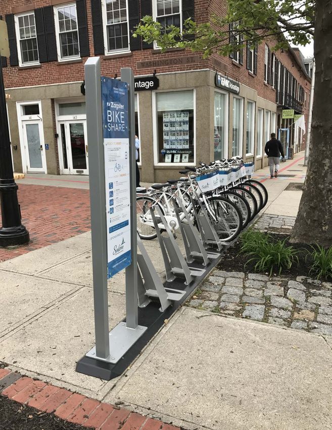
iv SALEM BICYCLE MASTER PLAN |
CONTENTS
Introduction..................................................................... 2

Existing Conditions........................................................... 6

Recommendations.......................................................... 16

Action Plan.................................................................... 30

                                                                      SALEM BICYCLE MASTER PLAN   |    v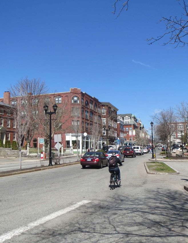
THIS PAGE INTENTIONALLY LEFT BLANK

vi   SALEM BICYCLE MASTER PLAN   |
Executive Summary
Salem is full of opportunities for bicycling. The City is
compact, features a well-connected street network, and
a diverse mix of land uses that make most trips within
the City possible by bike. The City’s public bicycle sharing
program has increased options for getting around by
bike. Bicycling is valued because it supports economic
and tourism growth. The community also understands
that better conditions for bicycling will attract and retain
residents, tourists, and students.

                                     SALEM BICYCLE MASTER PLAN   |    vii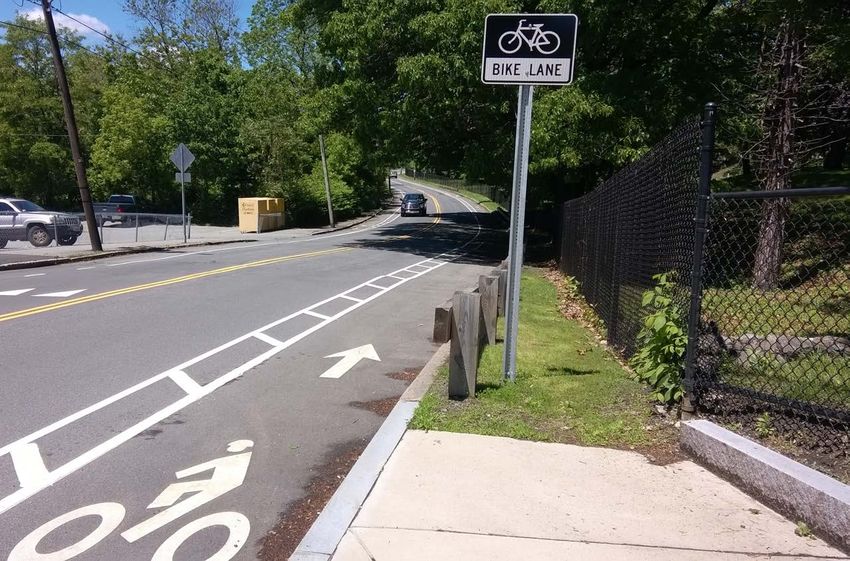
The Salem Bicycle Master Plan (the Plan) was created to
  establish a vision and plan of action for making Salem a place
  that is bikeable for people of all ages, abilities, and backgrounds.
  While the City has invested in bicycle infrastructure, there are
  many barriers that prevent people from bicycling more. Many
  people are interested in bicycling as a fun, healthy, low-cost
  transportation option, but are discouraged by routes with little
  or no separation from motor vehicles on high-speed and high-
  volume streets. Other issues, such as lack of bike parking or
  maintenance of trails can also deter people from bicycling.

  The Plan was developed to address these issues through
  discussions with stakeholders, members of the public and
  City staff. It included a review of work the City has already
  completed, and analysis of existing conditions, and safety
  concerns for people biking in Salem. Through this process, over
  100 infrastructure projects and policy changes were identified
  that will enable the development of a safe, high-comfort network
  of bikeways that will connect to destinations throughout Salem.

  The projects identified in the Plan range from small traffic
  calming interventions in North Salem and the Point, to improved
  connections at Leslie’s Retreat Path, to new bike lanes on many
  of Salem’s main corridors. The projects in the Plan will not
  only provide a safer and more comfortable environment for
  people biking, but will support Salem’s other livability, mobility,
  economic, and environmental goals. Investments in biking
  will take place over time and all projects will be thoughtfully
  integrated into Salem’s existing transportation system. The final
  section of this document, the Action Plan, serves as a guide
  for making these smart, strategic investments with projects
  prioritized and organized into short, medium, and long-term
  projects.

  Many people turn to biking as an affordable, convenient, healthy,
  and fun way to move around Salem. With the implementation
  of this Plan, Salem will become a place that is bikeable for
  everyone, from eight-year-old children on their way to school,
  to working professionals destined for the train, to 75-year-old
  grandparents out for an evening ride.

viii   SALEM BICYCLE MASTER PLAN            |
THIS PAGE INTENTIONALLY LEFT BLANK

                               SALEM BICYCLE MASTER PLAN   |    ix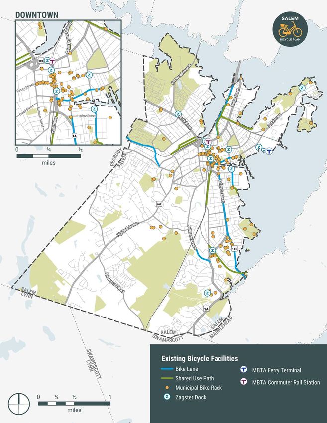
THIS PAGE INTENTIONALLY LEFT BLANK

x   SALEM BICYCLE MASTER PLAN   |
1 Introduction
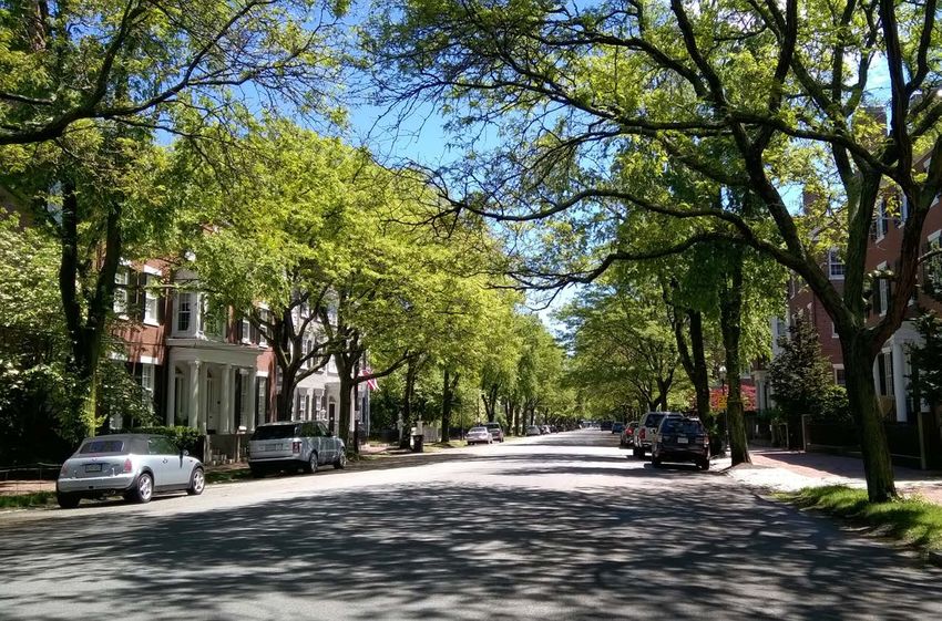
Salem has all of the bones of a premiere biking city. At
just over eight square miles, Salem’s size is one of its
greatest assets. The City offers a rich density of activity
– cultural institutions, historic attractions, educational
and employment centers, parks, and more – within short,
bikeable distances of its residential neighborhoods and
transportation hubs. Furthermore, biking supports the
community values and vision set forth in Imagine Salem,
the City’s comprehensive plan. Recognizing its enviable
position as a city fit for bicycling, this Bicycle Master
Plan represents an important step toward realizing an
equitable and sustainable transportation future based on
smart investments that will improve safety, livability, and
transportation choices for its residents and visitors.
SALEM BICYCLE MASTER PLAN | 1Introduction
The Salem Bicycle Master Plan was born out of the The relatively small size of the city is an asset for biking (See
community that it will serve – the people who live, work, and Figure 1). From any point within the city’s boundaries, the core
travel throughout Salem, regardless of mode. A balanced of Downtown can be reached within a bike ride of approximately
transportation system that supports biking as an attractive three or less miles (under 30 minutes riding time). Because
and safe option for people of all ages and abilities is essential of the physical exertion required for biking, distance is a main
for continued economic growth, community health outcomes, factor people consider when deciding whether a trip may be
and quality of life for all people in Salem. Working together with made by bike or not. In Salem’s case, virtually every trip within
other transportation options available in Salem – walking, train, the City is of a bikeable distance.
bus, ferry, and personal vehicle – biking offers an important
transportation option that is widely accessible to virtually all
people regardless of where they live, their age, or their income.
The Planning Process
Whether people choose to travel by bike, have few other options, Beginning in the fall of 2017, the City of Salem launched
or ride around Salem simply for fun, this Plan charts a course for the planning process by identifying a Steering Committee
providing the infrastructure, policy, and programming necessary comprised of City Councilors, municipal department leaders,
to support biking for all people in Salem. advocates, members of Salem’s Bicycle Advisory Committee,
and other community stakeholders. The Steering Committee
Bikeable Salem was selected in recognition of the collaboration and consensus-
building required to plan, design, and implement meaningful
The city’s land mass of eight square miles includes dense, changes to the built and policy environment in Salem.
mixed-use residential and commercial areas near downtown and
a majority of single family residential neighborhoods away from With the Steering Committee as a guiding force throughout
the city’s center. Salem possesses a wealth of recreational and the Plan development, the community was engaged through
natural areas, including 18.5 linear miles of shoreline on its north a variety of outreach methods to collect feedback about the
and east sides. Salem is home to approximately 44,400 people,1 current state of bicycling in Salem, including barriers to bicycling
and the city hosts over a million tourists each year who come to and priorities for improvement. The outreach strategies used
experience the rich historic and cultural legacy of the city. are outlined below:
Steering Committee: The 15-person Steering Committee met
four times throughout the planning process and played a
pivotal role in the early community engagement efforts, project
prioritization, and general plan review.
Listening Sessions: A series of listening sessions were held with
14 stakeholder groups and focused on the unique expertise or
interest of the interviewee(s). Through the listening sessions,
the City gained evaluated specific policy and regulatory
conditions – such as zoning requirements and site plan review –
as they relate to biking.
Community Bike Rides: Two community bike rides were held in
December 2017 that covered two routes starting and ending at
the Salem Commuter Rail station (an 11-mile loop and a 9-mile
loop). The general public were invited to attend the bike rides
and despite snowy and cold conditions, those in attendance
were well-acquainted with bicycling in Salem and shared a
detail-rich narrative of the current conditions for bicyclists.
Public Open House: An interactive open house was held in
Figure 1: Distance to Downtown from Around Salem 1 U.S. Census Bureau Annual Estimates of the Resident Population: July 1,
2017
2 SALEM BICYCLE MASTER PLAN | INTRODUCTIONFebruary 2018 to spark the community conversation about Thank You For
Participating!
specific challenges the bike Plan should address. In addition to
a brief presentation about the Plan, members of the public were
prompted by a series of hands-on activities to identify streets
that are challenging for biking, what kinds of infrastructure the
community would like to see, and where people want to travel to
and from by bike. Steering Committee Members
Online Interactive Map: An online interactive map was used to
identify current routes and destinations in Salem, as well as Members of the Public
desired routes and destinations. The map was open for user
feedback from between December 2017 and March 2018,
during which time 179 users logged 509 unique insights about Listening Session Participants
their current and desired routes and destination in Salem. The
Andrew Zimmerman, RCG
wikimap received comments from daily bike riders, casual and
infrequent riders, and those who do not ride at all. Salem Maritime and Saugus Ironworks National
Historic Sites
In addition, completed and ongoing planning initiatives were
consulted to ensure this Plan built on and coordinated with Beth Debski, The Salem Partnership
existing City efforts.
David Valecillos, North Shore Community
Development Coalition
David Pabich, Salem Renewal, Salem Bicycling
Advisory Committee
Jason Consalvo, Salem Five Bank, Salem Rotary
Andy Goldberg, Goldberg Properties
Salem State University
North Shore Medical Center
South Salem Neighborhood Association
Bob Monk, Security Operations and Planning, Peabody
Essex Museum
Kelley Rice, Salem Public Schools
Steve Feldman, Salem Business Owner
Community Bike Ride Attendees
Tom Devine, City of Salem
Matt Smith, City of Salem
Eric Papetti, Steering Committee
Paul Tucker, Massachusetts State Representative
The public discussed biking in Salem at the Public Open House
Christine Madore, City Councilor, Ward 2Imagine Salem: Transportation Guiding Principles
Salem believes in an accessible local and regional Streets should be designed to enable active and sustainable
transportation system that provides alternative transportation modes. The transportation system will work
modes of transportation and choices. Salem aims best when people who can reasonably walk, bike, or use
to have a true multimodal transportation system that transit can do so safely, comfortably, and reliably. Making
encourages active and sustainable transportation these modes work is especially important for trips taken
choices for everyday trips and empowers all travelers along existing transit lines and for short trips within Salem
to safely use the streets. The City recognizes the and to adjacent communities. By enabling these modes,
crucial role that a sustainable transportation system valuable “real estate” in the public right of way will become
plays in opening up opportunities for the Salem free. Allowing people to not use their cars unnecessarily
community. relieves traffic congestion, increases retail foot traffic, fosters
community, and ameliorates public health.
People should have options when choosing to get
around the city regardless of their age and ability. The transportation system should be design for safety and
People have differing preferences and abilities, and a “Vision Zero” standard. Major injuries and deaths from
therefore choice should be embedded in all parts of traveling are largely if not entirely preventable. Improper street
the transportation system. In many places, providing designs, including those that incentivize fast travel speeds,
choice entails rebalancing streets after nearly 80 can increase the likelihood of casualties. When reconfiguring
years of automobile-oriented investment. In other streets, Salem should design for low speeds and low
places, it means designing streets and sidewalks casualties in its neighborhoods. Ultimately, Salem should aim
to be ensure safety and comfort for all users, to have zero deaths and major injuries—a standard called
particularly the elderly and people with disabilities. “Vision Zero.”
Elements of the transportation system should The transportation system should complement
connect, so that the system becomes multimodal. It neighborhoods. Quality of life in Salem’s neighborhoods
is unreasonable to expect all transportation modes to should be bolstered by the transportation system. Rather
work for all trips, and creating independent systems than communities accommodating inflexible transportation
for all transportation modes would be redundant in infrastructures, the transportation system should be designed
many places. The transportation system should allow with the unique character of each neighborhood in mind.
travelers to string together different mode choices
where appropriate.
Other Current and Ongoing Planning Initiatives
• 2012 North River Canal Corridor Plan • Essex Street Pedestrian Mall Conceptual Plan
• 2015-2022 Open Space and Recreation Plan • Imagine Salem Comprehensive Plan
• 2016 Route 107 Corridor Study • MAPC LandLine Network Plan
• 2017 1A – Vinnin Square Priority Corridor Study • Salem Complete Streets Prioritization Plan
• 2017 MassDOT District 4 Enhancement Plans • Salem Power Station Redevelopment Plan
• Bates Elementary Safe Routes to School Plan • South Salem Commuter Rail Station Conceptual Plan
• Canal Street Rail Trail Extension Plans • Various studies completed for Bridge, Boston, and North
Streets (including MBTA access studies)
• East Coast Greenway Network
SALEM BICYCLE MASTER PLAN | INTRODUCTION2 Existing Conditions
Salem will soon celebrate its quadricentennial. Nearly 400
years of history, technological advancement, and growth
are embedded into Salem’s streets, reflecting the ever-
changing nature of the City. This Plan is responsive to the
existing environment to ensure the Plan recommendations
work in the service of the Salem that exists today, while
anticipating and preparing for the needs of Salem in the
future.
SALEM BICYCLE MASTER PLAN | INTRODUCTION 5Existing Conditions
This section summarizes the current state of biking in Although the current bike mode share in Salem is relatively
Salem. Using existing city-wide data, public input, and field small – just one percent of people in Salem report biking as
observations, the existing conditions described below their primary mode to traveling to work 2 – the community
establish the framework that was used to craft the Plan processes completed for this Plan, as well as Imagine Salem,
recommendations. By first examining Salem’s current demonstrate a strong preference for increasing the share of
characteristics and the City’s efforts to build out a network for trips made by active modes and expanding low-cost, reliable
biking, the future comes into focus: Where are opportunities transportation options, like biking.
to fill network gaps and better connect people to desired
destinations? Where do constraints exist that may preclude or Multimodal Connectivity
complicate future intervention? What are the main barriers that
prevent people from biking, and how can thy be overcome? Salem’s transit hubs are among the most important destinations
for Salem residents. The scale of Salem makes biking an
Travel Patterns extremely convenient choice for people who use the commuter
rail, ferry, or bus service for longer-distance travel. Through trip
chaining – linking together two or more legs of a trip through
Though compact in size, Salem is comprised of a variety of
various modes – biking may be used for the first or last segment
neighborhood types and scales. From the densely-settled
of a trip to make longer-distance trips possible without the use of
Point neighborhood to the suburban environment in Witchcraft
a car. In this way, biking is a far more effective tool than walking.
Heights to the bustling Downtown core, Salem residents rely on
While only 20% of Salem residents can reach the commuter rail
a variety of transportation tools to travel between their homes
or ferry within a 10-minute walk, 70% can reach the two transit
and places around Salem.
hubs within a 10-minute bike ride (See Figure 2). Data from the
Outreach to the Salem community revealed the many ways MBTA and other recent studies illustrate the importance of and
people currently use a bike to experience Salem. People in connection between biking and transit use in Salem. The Salem
Salem bike to reach their jobs, local parks, and daily destinations commuter rail station is one of the most heavily used in the entire
(such as shops or restaurants). In addition, a significant MBTA system, with weekday ridership over 2,000.3 Data from the
percentage of people bike to make their transit connections. 2015-17 MBTA Systemwide Passenger Survey shows that the 90
60%
58%
50%
40%
30%
27%
20%
10 min. walk
10%
3% 11% 2%
10 min. bike ride
0%
Walk or Bike Drive Alone Carpool Drop off by Drop off by
Personal Other Vehicle
Vehicle
Figure 3: Mode Used to Access Salem Commuter Rail Station
Figure 2: Salem’s Access to Commuter Rail and Ferry
2 American Community Survey. 2016. United States Census Bureau.
Terminal via a 10-minute Walk vs 10-minute Bike Ride
3 Forman, Ben and Hodge, Daniel. The Promise and Potential of Trans-
formative Transit-Oriented Development in Gateway Communities. 2018.
MassINC.
6 SALEM BICYCLE MASTER PLAN | EXISTING CONDITIONSpercent of people taking the commuter rail daily do so for work School
trips, with 72 percent of passengers taking the train five days Shopping Work
weekly.4 3%
8% 14%
Social/
Of the people who board the commuter rail in Salem, 12 percent Entertainment
do not have access to a car and 11 percent are from low-income 15% Utility Trips
households earning $43,500 per year or less. Owing to the 59%
overall scale of the city and the relatively dense development Non- Utility
Trips
pattern around the station (over 3,000 working-age people 9%
Dining 41%
live within a half-mile of the station), walking and biking are 41%
attractive modes for access to and from the train; As shown in 10% Recreation
Figure 3, over 1,200 (58 percent of riders) access the station via Transit
walking or biking while 27 percent access the station by driving Connection
alone.5 6
Figure 4: Current Biking Destinations by Type
The importance of multimodal connections was echoed
throughout the public process completed for this Plan. Fully ten recreation, people most frequently bike for transportation
percent of all biking destinations identified by the public were purposes (See Figure 5).
concentrated at just two locations: the MBTA commuter rail
station and ferry terminal. Salem plays a significant role in the regional employment and
consumer economy, with tens of thousands of people traveling
Utility Trips in, around, and out of Salem daily for access to jobs and other
daily destinations. Approximately half of Salem’s residents are
Utility trips – those made for transportation purposes to work, of working age (21,801 residents 16 years or older),7 and 19% of
school, shopping, or other daily destinations – play a significant those residents work within Salem.8 An additional 17,000 people
role in the number of people biking around Salem every day commute into Salem each day for work. Salem has clusters
(See Figure 4). Although many in the community bicycle for of high-activity employment and shopping located Downtown,
40%
35% 37%
30% 32% 33%
25%
25% 24%
20% 22%
20%
15%
10%
5% 7%
0%
Daily or almost daily A few times each week A few times each month A few times each year
Recreation Transportation
Figure 5: Biking Frequency of Current Bicyclists in Salem by Trip Type
4 2015-2017 MBTA Systemwide Passenger Survey. Central Transportation Planning Staff.
5 2015-2017 MBTA Systemwide Passenger Survey. Central Transportation Planning Staff.
6 Forman, Ben and Hodge, Daniel. The Promise and Potential of Transformative Transit-Oriented Development in Gateway Communities. 2018. MassINC.
7 American Community Survey. 2016. United States Census Bureau.
8 Imagine Salem Progress Report. 2017. City of Salem.
SALEM BICYCLE MASTER PLAN | EXISTING CONDITIONS 7along Highland Avenue, and in pockets of southeastern Salem.
High concentrations of workers report to a single or small Salem’s Bike Network
handful of locations for the city’s largest non-government
In the intervening years since the 2010 Bicycle Circulation
employers such as North Shore Medical Center (over 3,000
Master Plan was completed, Salem has made many positive
employees) and Salem State University (approximately 1,500
changes that have made biking accessible. Several miles of bike
employees). Major shopping destinations also include regional
lanes and new shared-use paths have been opened, creating
malls, such as Northshore Mall in Peabody and Liberty Tree Mall
new routes and options for moving around the City. However, the
in Danvers. While some people currently bike to these areas,
current system of bike infrastructure does not always provide
the existing infrastructure does not provide a sense of safety or
adequate separation or connectivity to make most people feel
comfort required to encourage a larger share of the population
that it is a safe way to travel. The primary challenge facing
to bike to their jobs or daily errands.
Salem is inadequate separation between people biking and
Biking for Fun driving along many of Salem’s main high-volume, high-speed
streets. These streets are the primary connectors in Salem
Salem contains dozens of parks of varying sizes located - those that carry people from neighborhoods to Downtown,
throughout the City, in addition to an exceptional array of Salem State, the ferry terminal, and other destinations described
cultural attractions. The broad distribution of the City’s parks above.
allows people who live in any neighborhood to access a
green space within a short distance of their home. Similarly, Existing Lanes and Paths
the vast majority of Salem’s museums and historic sites are
As shown in Map 1, Salem currently has approximately seven
concentrated within the Downtown area, making it easy to travel
miles of bike infrastructure installed throughout the City,
between sites using active modes.
including just under three miles of off-street shared use path
The strong tourist economy in Salem brings over a million and approximately four miles of on-street bike lanes. While
people into Salem, most within a short time period around these bike lanes and paths are useful tools for a portion of the
October. The heavy influx of people into Salem strains all population, most of the on-street bike facilities that exist today
modes of transportation, placing an even greater emphasis on are along relatively high-volume, high-speed streets and do not
the need for transportation choices to support the increased prove any separation between people biking and moving traffic.
demand. The availability of Salem’s hybrid dockless bikeshare As a result, the majority of Salem’s existing on-street lanes are
system gives tourists access to the whole of Salem by bike. considered low-comfort. National research shows that routes
With a concentration of docking stations located Downtown, the like these are likely to attract a maximum of around seven
system is especially well-equipped to handle visitors to Salem’s percent of the total population, while an additional 65 percent
main tourist attractions. would consider biking if routes provided a more comfortable
ride. In Salem, the public identified the primary reasons they
don’t currently ride a bike, demonstrating that for a greater bike
60% mode share to be achieved, greater comfort and separation is
59% required along Salem’s streets (See Figure 6).
50%
40%
Comfort and Safety
42%
Salem’s bicycle network currently supports a small population
30%
of highly confident bicyclists who are willing to ride on roads
with traffic and without bike lanes. By contrast, most people
20%
22% (51-56%) are interested in biking but concerned about safety
20%
10% and seek off-street or separated bicycle facilities or quiet,
14%
traffic-calmed residential roads (See Figure 7).9 This research
0% is supported by feedback collected from Salem residents who
No bike Too much No secure Feels unsafe Other identified ‘no bike facilities on part of my route’ and ‘too much
facilities on traffic on place to for children
traffic on my route’ as the main reasons they currently elect to
part of my my route park my
route bike not travel by bike.
Figure 6: Community-Reported Challenges to Biking in Salem 9 Dill, D. and N. McNeil. Revisiting the Four Types of Cyclists. In Transpor-
tation Research Record 2587. TRB, National Research Council, Washington,
DC, 2016.
8 SALEM BICYCLE MASTER PLAN | EXISTING CONDITIONSMap 1: Existing Bicycle Facilities SALEM BICYCLE MASTER PLAN | EXISTING CONDITIONS 9
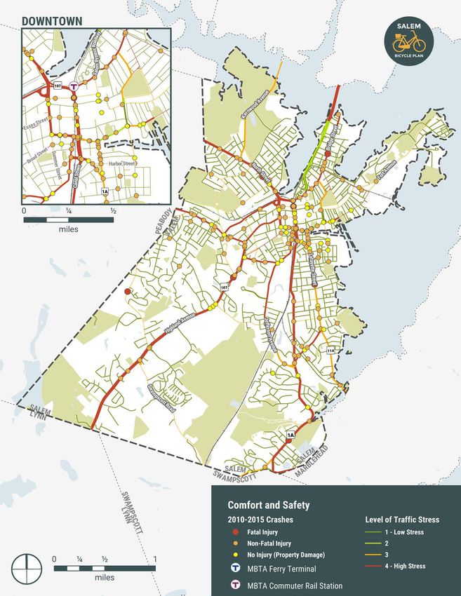
The community’s perception of unsafe conditions was                   A comparison of the Level of Traffic Stress analysis and crash
 examined alongside the numerical results of a crash analysis          data for the most recent five years show a trend between
 and a Bicycle Level of Traffic Stress tool that quantifies how        high-stress streets and the crashes resulting in serious injury
 comfortable a given route is based on the road context. The           or death. Most crashes (57%) were located along high-stress
 analysis evaluated characteristics that most strongly contribute      streets, and a high concentration of crashes occurred in the
 to bicyclist comfort: the level of separation from motor vehicles,    dense and busy Downtown street network. Of the total 245
 traffic volume, and traffic speed. A weakest link principle was       crashes involving vulnerable users, seven crashes resulted in
 then used to score road segments based on vehicular speed,            the end of a person’s life.
 volume, curbside use, and bicycle facility width/separation.
 The lowest-stress segments (LTS 1) are suitable for almost            Bike Parking
 all people – including children – to bike on while the highest-
 stress segments (LTS 4) require riding near and negotiating with      An often-overlooked component of bike infrastructure is bike
 moderate to high-speed traffic.                                       parking. The City has installed a variety of bike racks with total
                                                                       capacity for 647 bikes around Salem. High-capacity racks
 The results of Salem’s Bicycle Level of Traffic Stress analysis       are located at Mack Park, Salem State University, Salem High
 are shown in Map 2. In general, Salem’s many local, residential       School, Carlton Innovation School, the ferry dock, and the MBTA
 streets were designated high-comfort due to the low traffic           garage near Salem Station. The location of municipal bike
 volumes and speeds found on those streets. The main streets           parking facilities is shown in Map 1. Although the majority of
 that carry the majority of people to the places they want to go       existing bike parking is centralized in the downtown area, Salem
 were generally categorized as high-stress or highest-stress.          residents still reported that this is where bike parking is most in
 These streets - some of which include existing painted bike           need of additional supply.
 lanes - do not provide separated infrastructure to mitigate
 exposure to significant traffic volumes and high speeds.

                                                 Figure 7: Bicyclist Design User Profiles

10   SALEM BICYCLE MASTER PLAN            |   EXISTING CONDITIONS
Map 2: Comfort and Safety SALEM BICYCLE MASTER PLAN | EXISTING CONDITIONS 11
Policies and Programs                                                         Comprehensive Planning
                                                                               In 2016 the City commenced the Imagine Salem planning
 Salem’s ability to provide a safe and comfortable biking
                                                                               process to establish a collective vision for the City’s future.
 experience throughout the City is dependent on how well biking
                                                                               The process is focused on achieving community, housing,
 is integrated into Salem’s routine processes and procedures.
                                                                               employment, and transportation goals by 2026, with a strong
 Biking in Salem is currently supported through several existing
                                                                               emphasis on providing greater access to active transportation
 policies and programs, described below. Although Salem
                                                                               modes throughout Salem. With its focus on bike network safety,
 has made progress toward achieving a bike network that is
                                                                               comfort, and connectivity, this Plan is directly in line with all of
 accessible for people of all ages and abilities, a primary focus
                                                                               the transportation goals identified by Imagine Salem.
 of this Plan is the coordination of City procedures and policies
 to ensure biking is built in as an upfront consideration in City              In addition, the Salem for All Ages initiative charts a course of
 decision-making processes.                                                    action for making Salem a livable place for the rapidly aging
                                                                               population in Massachusetts. The plan provides a vision for
 Bicycling Advisory Committee                                                  accessible and affordable transportation options, leaning on
                                                                               the highly-walkable environment provided throughout Salem. A
 In June 2006 the City established the Salem Bicycling Advisory
                                                                               key plan initiative points to the need to evaluate the safety and
 Committee to help guide Salem’s bike path network and
                                                                               walkability of intersections throughout Salem. Although Salem
 promote a bike and pedestrian-friendly environment citywide.
                                                                               for All Ages does not identify bicycling as a transportation
 The committee coordinated with City staff and a consulting
                                                                               strategy, evidence suggests that supportive policies to improve
 team to produce Salem’s first-generation bike plan, the 2010
                                                                               bicycling infrastructure – as well as technology enhancements
 Bicycle Circulation Master Planning Study, which identified a
                                                                               such as electric bicycles – may increase rates of bicycling in
 4.85-mile pilot route consisting of shared use paths, bike lanes,
 and shared lane markings connecting Winter Island south to                    older population groups.10 11
 Marblehead. The City has implemented this route in stages, with
 many shared lane markings and lanes completed. In their role                  Policies
 as advisors to the City, the Bicycling Advisory Committee’s will
 continue to be engaged in City-led initiatives including planning             The City established a Complete Streets policy in 2014
 and engineering projects that affect biking.                                  that seeks to make every Salem transportation project an
                                                                               opportunity for improving streets for all transportation modes.

     Salem’s bikeshare system launched in 2017 with 10 stations around Salem, primarily in the Downtown area

 10 Complete Streets Improve Mobility for Older Americans. National Complete Streets Coalition, Smart Growth America.
 11 Renee, J., and Bennett, P., Socioeconomics of Urban Travel: Evidence from the 2009 National Household Travel Survey, World Transport Policy and Prac-
    tice 20(4):7-27. September 2014

12      SALEM BICYCLE MASTER PLAN              |   EXISTING CONDITIONS
The City’s policy and associated prioritization plan opens
the door for the City to receive funding through MassDOT’s
Complete Streets Funding program, which allocates up to
$400,000 for municipal projects selected through a competitive
Salem Complete
application process. Thus far Complete Streets funding has
been awarded for upgrades to Boston, Bridge, and Goodhue
Streets Policy
Streets.
Site plan review is a primary vehicle for reviewing and guiding The City recognizes that all road-
changes to the built environment in Salem. As part of the City’s
site plan review process, applicants must disclose the location
way projects – including new
and dimensions of all bicycle racks and storage areas, however construction, maintenance and
there is no requirement to include these facilities as part of reconstruction – are potential
a project. Although zoning does not currently mandate bike
parking requirements for new development, the City maintains
opportunities to apply Complete
an updated inventory of all municipal bike parking, and is Streets design principles. The City
currently in the process of preparing bike parking guidelines for will, to the maximum extent prac-
private developments. tical, design, construct, maintain,
Programs and operate all streets to provide
for a comprehensive and integrated
The City participates in the federally-funded MassDOT Safe
street network of facilities for peo-
Routes to School (SRTS) initiative, which seeks to provide
students with an opportunity to walk or bike to school on a ple of all ages and abilities.
frequent basis. In Salem, there is significant opportunity to
improve the share of people walking and biking to school.
Travel data for the over 4,000 public school students in Salem expressed support for biking infrastructure throughout Salem,
demonstrates that 39 percent arrive by bus and much of the noting that compliance by all users increases with dedicated
remaining 61 percent arrive by car. Though the SRTS program, infrastructure.
Walk to School days, bike rodeos, and other programs are
Finally, Salem launched a bike share program in 2017 with 50
coordinated with five local schools – Bates Elementary, Bentley
bikes available at 10 stations. In its first year of use, the system
Elementary, Horace Mann Laboratory, Nathaniel Bowditch,
accommodated approximately 2,500 rides. The city also piloted
and Saltonstall. In addition, Bates Elementary school was the
a Zagster feature that allowed users to lock a bike at any bike
recipient of MassDOT SRTS infrastructure funding for a safety
rack in addition to designated docks around the city. In general,
improvement project that will include signal upgrades and
the Zagster docks are concentrated around Downtown with one
sidewalk improvements. The Bates Elementary School SRTS
station on the Salem State University Campus and one in North
infrastructure project is currently in preliminary design.
Salem. Through public engagement, the Salem community
Salem also supports improved conditions for biking through a shared concerns that current system is limited geographically,
recently instituted neighborhood traffic calming program that and that additional docks or stations outside of Salem (for
provides residents the opportunity to request traffic calming example, in Marblehead) would provide additional functionality
through a formal application process. Two projects are currently to residents and employers in Salem. Others suggested that
underway and slated to be installed during the 2018 season. the cost of a membership acts as a disincentive for some of
The program is currently administered through the City’s Salem’s lower-income residents. Several stakeholders involved
Engineering Department, but will receive dedicated funding in development activity suggested that bikeshare should be
through the City’s Capital Improvement Program for future better promoted, especially to new residents.
years.
Salem is supportive of enforcement educations programs, and
was one of 12 initial communities to participate in the MassDOT
Bicycle and Pedestrian Safety Awareness and Enforcement
Program in 2014. Approximately 30 officers have completed
the Massachusetts Police Mountain Bike Patrol School training.
Through this Plan’s outreach process, the Police Department
SALEM BICYCLE MASTER PLAN | EXISTING CONDITIONS 13THIS PAGE INTENTIONALLY LEFT BLANK 14 SALEM BICYCLE MASTER PLAN |
3   Recommendations
    Planning for a more bikeable future will require the
    coordination, time, and resources of many City
    departments, neighboring jurisdictions, and the public.
    The recommendations of this Plan address specific
    infrastructure changes, city policy, and programming
    that will enable the development of citywide network of
    bikeways that is comfortable for people of all ages and
    abilities.

                                       SALEM BICYCLE MASTER PLAN   |    15
FHWA’s Principles of Recommendations
Connected Networks The recommendations were developed based on the review of
existing conditions, ongoing planning and design efforts, and
with the input of community members, the Steering Committee,
and City staff. Recommendations align with the six principles
Safety and Security for connected bike networks as identified by the Federal
Does the network provide routes that minimize risk of Highway Administration as described below.
injury, danger, and crime?
The recommendations of the Plan are grounded in a
Comfort commitment to safety, security, and comfort. Along busy, fast,
or wide streets, shared use paths and separated bike lanes
Does the network appeal to a broad range of age and
are preferred because they provide the greatest degree of
ability levels with consideration given to user amenities?
separation from motor vehicles (See Figure 8). Conventional
or buffered bike lanes may be appropriate on streets with
Cohesion moderate volumes and low speeds and where parking turnover
How connected is the network in terms of its is low. Neighborhood greenways are reserved for low-volume,
concentration of destinations and routes? low-speed local streets. While the bikeway solutions selected
for each recommendation reflect a planning level analysis of
Directness traffic volume, speed, road width, and other factors, the final
Does the network provide direct and convenient selection and design of each facility will require detailed site
access to destinations? analysis and additional public outreach.
The recommendations address other infrastructure
Access components that contribute to comfort and safety, such as
How well does the network accommodate travel for wayfinding signage, bike racks, and intersection treatments
all users, regardless of age, income level, or ability? such as bike crossings and queue boxes. An additional design
consideration that will affect project design and implementation
Alternatives is the character of Salem’s streets and historic districts. Bicycle
Are there many different route choices available facilities can be designed to minimize pavement markings and
within the network? signage or to integrate them into an aesthetic scheme that
preserves community identity and historic contexts.
Cohesion and access were considered in terms of how the
10k+
network could connect Salem’s high-demand employment,
9k Shared Use Path or shopping, and recreation destinations. Recommendations
Separated Bike Lane focus on creating a dense network of bikeways in the busy
8k Downtown area, with routes connecting Downtown to all areas
of Salem. Routes that increase access to the MBTA Commuter
7k
Rail Station, MBTA Ferry Terminal, and bust stops were also
Motor Vehicles per Day
6k prioritized given their unique value to the transportation network.
5k Bike Lane Directness and alternatives were balanced by comparing the
(Buffer Pref.) feasibility of developing safe and comfortable routes on main
4k streets versus parallel local streets. As research shows, most
people are willing to lengthen a trip only by 25 percent1 to avoid
3k
difficult traffic conditions, alternatives requiring significant
2k
out-of-direction travel were not substituted for high-comfort
Neighborhood bikeways on busy corridors.
1k Greenway
1 Winters, M., K. Teschke, M. Grant, E. Setton and M. Bauer. How Far
0 Out of the Way Will We Travel?: Built Environment Influences on Route
15 20 25 30 35 40 45 50 55 60+
Selection for Bicycle and Car Travel. Transportation Research Record:
Speed (MPH) Journal of the Transportation Research Board, No. 2190, 2010, pp. 1-10.
Figure 8: Facility Selection Guidance
16Designing for Comfort and Safety
The following bikeway treatment types are identified throughout
the Plan recommendations:
Shared Use Path Separated Bike Buffered Bike Conventional Bike Neighborhood
A shared use path is Lane Lane Lane Greenway
physically separated A separated bike lane A buffered bike lane is A conventional bike lane A neighborhood
from traffic and permits is physically separated an on-street bikeway is an on-street bikeway greenway (or bike
two-way operations from traffic with separated from an delineated from an boulevard) is a low-
for use by all non- vertical and horizontal adjacent travel lane or adjacent travel lane volume, low-speed
motorized users. elements. They may be on-street parking lane or on-street parking street – typically a
designed for one-way by a striped buffer area. lane with pavement local street – that has
or two-way use and markings. prioritizes bicycle travel
may be constructed at with signs, pavement
the street, sidewalk, or markings, traffic
intermediate level. calming measures, and
enhanced crossing
treatments.
Shared Separated Buffered
Use Path Bike Lane Bike Lane
≥12’ ≥6’ Rec. Rec. ≥6.5’ ≥6’ Rec. 4’ 6’
10’ 2’ Min. Min. 5’ 2’ Min. 3’ 5’
Conventional Neighborhood
Bike Lane Greenway
Rec. 6’
Min. 5’
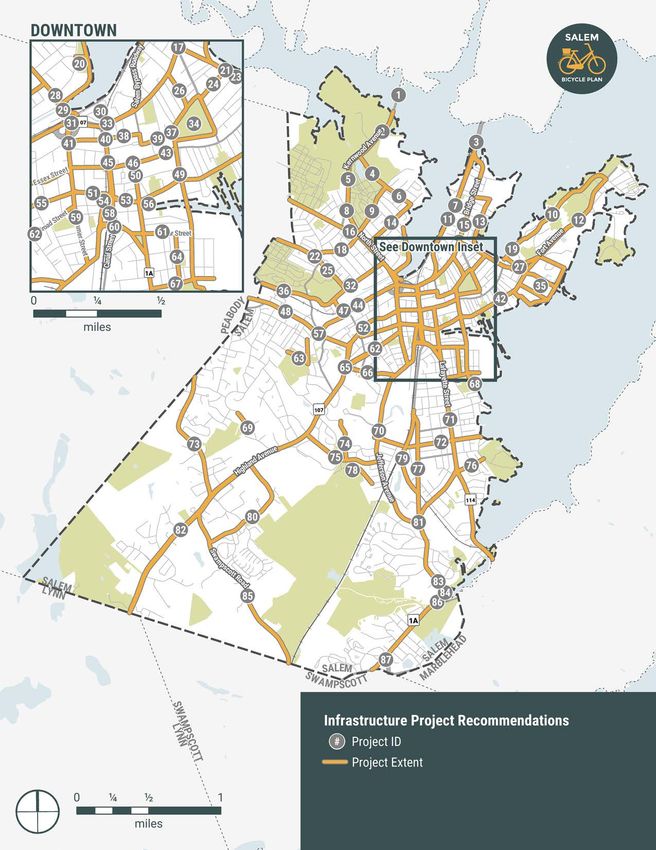
SALEM BICYCLE MASTER PLAN | RECOMMENDATIONS 17Map 3: Infrastructure Project Recommendations 18 SALEM BICYCLE MASTER PLAN |
Infrastructure                                                    8    Liberty Hill Avenue at Appleton Street
                                                                       Tighten intersection and improve communication of
Recommendations                                                        traffic control.

Eighty-seven infrastructure recommendations are listed                 Current Initiative: Bates Elementary School SRTS
according to their position on a map of Salem (See Map 3).             Infrastructure Project
The Action Plan in the following section provides additional
information on cost and funding sources, suggested time to        9    Orne Street
completion, feasibility, and physical or other constraints.            Provide bike lanes along Orne Street from North Street to
                                                                       Sargent Street.
 1    Kernwood Avenue Bridge
      Add conventional bike lanes to Kernwood Avenue bridge.
      Consider a wider shared use path on one side of the         10   Szetela Lane, Memorial Drive, Restaurant Row
      bridge to accommodate people biking and walking in               Provide on-street conventional bike lanes from Settlers
      a completely separated environment. Consider adding              Way to Bay View Avenue via Memorial Drive and
      non-slip plates across bridge grates to improve traction.        Restaurant Row.

 2    Kernwood Avenue                                             11   Sgt. James Ayube Memorial Drive
      Provide conventional bike lanes along Kernwood Avenue.           Install vertical separation along existing bike lane on
                                                                       Sgt. James Ayube Memorial Drive from Bridge Street to
 3    Essex Bridge (Sgt. James Ayube Memorial Drive)                   proposed connection on Essex Street Bridge.
      Coordinate with MassDOT to provide separated bike
      lanes on the Essex Bridge extending from Sgt. Ayube         12   Fort Avenue
      Drive into Beverly. Consider grade-separated or concrete         Narrow parking lanes to provide buffered or separated
      barriers to provide adequate protection from high-speed          bike lanes along Fort Avenue. Coordinate with Salem
      traffic. Coordinate with Beverly to provide continuous           Power Plan development to strengthen bicycle
      high-comfort route.                                              connectivity.

 4    Sargent Street                                                   Current Initiative: Salem Power Plan Study
      Provide neighborhood greenway treatment from Orne
      Street to Kernwood Avenue.
                                                                  13   Collins Street, East Collins Street, and Planters
                                                                       Street
                                                                       Transition Peter Tracy Multiuse Path / Collins Cove Path
 5    Liberty Hill Avenue, Appleton Street                             to an on-street bike lanes. Provide connection from end
      Provide buffered or separated bike lane on Liberty Hill          of path to Bridge Street Neck via Collins Street, East
      Avenue from Appleton Street to Kernwood Avenue.                  Collins Street, and Planters Street
      Consider a shared use path along the east side of the
      street (against the cemetery).
                                                                  14   Dearborn Street
      Current Initiative: Bates Elementary School SRTS                 Provide neighborhood greenway treatment from North
      Infrastructure Project                                           Street to Felt Street.

 6    Felt Street                                                 15   Bridge Street Neck
      Provide neighborhood greenway treatment from                     Provide buffered bike lanes on Bridge Street.
      Dearborn Street to Kernwood Avenue

 7    Bridge Street Neck Path
      Evaluate feasibility of extending Bridge Street Path to
      close gap between Skerry Street and Burnside Street
      between Sgt. James Ayube Memorial Drive and Essex
      Bridge.

                                                                                        SALEM BICYCLE MASTER PLAN          |      19
16 North Street 24 Andrew Street
Consider quick build project to complete minimum grid. Provide neighborhood greenway treatment to connect to
Narrow existing travel and parking lanes to provide Salem Common.
buffered bike lanes extending from Franklin Street
to the Peabody Town Line. Carry bike lanes through 25 Tremont Street
all intersections. Coordinate with Peabody to provide Provide conventional bike lanes along Tremont Street
continuous high-comfort route. between Peabody Town Line and Mason Street.
Current Initiative: Complete Streets Prioritization Plan;
2010 Bicycle Circulation Master Planning Study 26 Winter Street
Provide separated bike lanes along Winter Street from
17 Bridge Street at Webb Street Salem Common to Bridge Street.
Provide transition opportunity for bikes exiting path to
turn left onto Bridge Street. Add bike box in front of stop 27 Collins Cove Path (Beattie Park)
bar for northbound Webb Street traffic. Extend Collins Cove Path east through City land and
David J. Beattie Park to connect to Derby Street in
Current Initiative: City-planned path extension
accordance with Complete Streets Prioritization Plan.
Provide crossing at Fort Avenue.
18 School Street
Provide buffered bike lanes on School Street between Current Initiative: Complete Streets Prioritization Plan
North Street and Tremont Street. Consider removing
center lines or other methods to calm traffic. Provide
28 North Street at Franklin Street
neighborhood greenway treatment on narrower section Improve crossing conditions for vulnerable users.
(close to North Street). Formalize and sign connection along North Street spur to
Commercial Street and Leslie’s Retreat Path.
19 Collins Cove Path
Extend and widen Collins Cove Path from terminus at 29 North Street Bridge
Webb Street to Settlers Way along waterfront desire line Consider quick build project to complete minimum grid.
in accordance with Complete Streets Prioritization Plan. Provide separated bike lanes along both sides of the
North Street Bridge.
Current Initiative: Complete Streets Prioritization Plan;
2010 Bicycle Circulation Master Planning Study; Collins Current Initiative: MassDOT District 4 Pedestrian and
Cove Living Shoreline Project Bicycle Upgrades at Various Locations
20 Furlong Park / Ferris Lot 30 MBTA Commuter Rail Station
Coordinate with landowners to provide shared use path Strengthen bicycle and pedestrian access to the train
connection along waterfront behind Furlong Park and station at the Bridge Street / Washington Street entrance
Ferris lot. Formalize goat path along North River across and from MBTA parking lots. Clarify bicycle route of travel
train tracks to connect to MBTA Commuter Rail station. through main entrance on Bridge Street / Washington
Street to lower platform and bike cage. Formalize
21 Entry to Peter Tracy Multiuse Path at Andrew Street / connections to station from Leslie’s Retreat Park and
Webb Street Intersection path behind former HMA site.
Widen entry to Peter Tracy Multiuse Path north of Andrew
Street / Webb Street intersection. Current Initiative: Complete Streets Prioritization Plan
22 Tremont Street at School Street 31 Leslie’s Retreat Path at Bridge Street (Path Entrance)
Tighten intersection. Formalize connection from Bridge Street and the MBTA
Commuter Rail Parking lot driveway to the entrance
23 Webb Street of Leslie’s Retreat Path west of the MBTA Commuter
Provide conventional bike lanes from Bridge Street Rail Parking Lot in accordance with Complete Streets
(connecting to Peter Tracy Multiuse Path) to Derby Street. Prioritization Plan.
Current Initiative: Complete Streets Prioritization Plan
20 SALEM BICYCLE MASTER PLAN | 32 Mason Street 40 Washington Street at Federal Street
Provide conventional bike lanes along Mason Street Stripe green bike lanes through the intersection and
between Flint Street and Tremont Street. Provide signage enhance crosswalk markings and signage to improve
to direct people to high-comfort options for crossing the pedestrian access to bikeshare station. Consider RRFB or
North River into downtown. other crosswalk enhancements.
33 Bridge Street (MBTA Commuter Rail Station) 41 North Street at Federal Street
Consider quick build project to complete minimum grid. In the short-term, complete proposed plans to stripe
Provide separated bike lanes on Bridge Street between conventional bike lanes through the intersection. In the
Bridge Street Neck and North Street. Install bike box long-term, consider reconstructing the intersection with
at Bridge Street / Washington Street intersection and tightened geometry and improved crossings for people
leading bike interval to allow bikes to maneuver into left biking and walking. Consider closing slip lane from North
lane to continue on Bridge Street and into the MBTA Street southbound, and formalize goat path to create
parking lot. Stripe green lane across intersection to high-comfort connection to Leslie’s Retreat path and
indicate movement for bikes going to MBTA parking low MBTA commuter rail through green space. Use jug handle
at lower level. to facilitate bikes turning left from Summer Street / North
Street into path. Widen crosswalk and path to provide
Current Initiative: Complete Streets Prioritization Plan a comfortable shared pedestrian / bike environment.
Provide queue box for bikes exiting path and entering
34 Salem Common Loop Summer Street southbound.
Provide continuous bikeway loop around perimeter of
Salem Common with strong access/egress connections Current Initiative: MassDOT District 4 Pedestrian and
on feeder streets (Andrew Street, Winter Street, Bicycle Upgrades at Various Locations
Hawthorne Street, and Brown Street.)
42 Derby Street
Provide bike lanes on Derby Street between Lafayette
35 Salem Power Station Redevelopment
Street and Fort Avenue. Consider parking-protected
Consider providing bike facilities and wayfinding
bike lanes on wider section (west of Orange Street).
throughout Salem Power Station Redevelopment site.
Consider contraflow lanes on Derby Street east of
Current Initiative: Salem Harbor Plan Update Orange Street. Current Complete Streets Prioritization
Plan recommendations include a mix of conventional
36 Harmony Grove Road bike lanes and shared use paths to improve connectivity
Consolidate right-of-way and narrow travel lanes to to the MBTA Ferry Terminal via full reconstruction east of
provide shared use path along one or both sides of Orange Street.
Harmony Grove between Grove Street and Peabody Town
Current Initiative: Complete Streets Prioritization Plan
Line.
43 Essex Street (Hawthorne Boulevard)
37 North Washington Square at Brown Street Consider traffic calming and wayfinding between New
Square off intersection to make public plaza. Liberty Street and Hawthorne Boulevard to clarify bike
connection to high activity pedestrian mall via this low-
38 Federal Street volume, low-speed segment.
Provide neighborhood greenway treatment from St. Peter
Street to North Street.
39 Brown Street
Provide neighborhood greenway treatment from the
Salem Common to St. Peter Street. Coordinate with
proposed pedestrian improvements documented in
Complete Streets Prioritization Plan.
Current Initiative: Complete Streets Prioritization Plan
SALEM BICYCLE MASTER PLAN | 2144 Bridge Street 48 Boston Street
Install separated bike lanes along Bridge Street Consider quick build project to complete minimum grid.
between Flint Street and Boston Street. Evaluate potential Provide separated bike lanes for the length of the street,
to widen north side of street to accommodate connected with buffered bike lanes near Bridge Street intersection.
bike lanes along Bridge Street between Rt. 114 ramp and Improve crossings for vulnerable users. Coordinate with
Flint Street. Formalize bike connection within shoulder Peabody to provide continuous high-comfort route.
area if widening is not possible. Complete planned
project to convert Bridge Street between Flint Street Current Initiative: 2012 North River Canal Corridor Study;
and Boston Street to a three-lane cross section with Bridge Street Massworks Project “Complete Streets”
separated bike lanes. Integrate design with proposed off- Enhancements; 2010 Bicycle Circulation Master Planning
street path connection from Grove Street to Bridge Street Study
behind self storage building.
49 Congress Street / Hawthorne Boulevard
Current Initiative: 2012 North River Canal Corridor Study; Provide buffered bike lanes as able from Ward Street
Bridge Street Massworks Project “Complete Streets” to Salem Common. Where space does not exist for
Enhancements buffering, provide conventional bike lanes.
45 Washington Street Current Initiative: 2010 Bicycle Circulation Master Planning
Consider quick build project to complete minimum grid. Study
Provide separated bike lanes on Washington Street
between New Derby Street and Bridge Street as a priority 50 Central Street at Essex Street Pedestrian Mall
north/south bike route. Consider a two-way facility on Consider converting Central Street to shared street from
the west side of the street as an extension of the Salem near Essex Street Pedestrian Mall to intersection with
Bike Path or one-way separated pairs on both sides of the Lafayette Street and Charter Street.
street.
51 Norman Street
Current Initiative: Complete Streets Prioritization Plan; Provide bike lanes on each side of the street between
MassDOT District 4 Pedestrian and Bicycle Upgrades at Summer Street and Margin Street. Consider removing or
Various Locations; East Coast Greenway link shortening right turn lane (coordinate with Margin Street
closure recommendation) to provide additional space for
46 Essex Street Pedestrian Mall separation.
Reconstruct the Essex Pedestrian Mall in accordance
with the Essex Street Pedestrian Mall Improvements Current Initiative: MassDOT District 4 Pedestrian and
project to improve accessibility and clarify travel zones. Bicycle Upgrades at Various Locations
Consider revising City ordinance to permit bike travel
along the Mall outside of the busy season (October). 52 Essex Street
Provide signage to inform people biking of seasonal bike Consider quick build project to complete minimum
restrictions. Provide wayfinding to bike parking locations grid. Provide separated bike lanes along Essex Street
outside of mall, and consider providing moveable bike between Jackson Street / Route 107 and Summer Street.
racks within mall. Construct bike lanes in accordance with proposed
Complete Streets Prioritization Plan for the segment
Current Initiative: Essex Street Pedestrian Mall Conceptual between Summer Street and Washington Street.
Design
Current Initiative: Complete Streets Prioritization Plan
47 Leslie’s Retreat Path at Flint Street
Formalize connection of terminus of Leslie’s Retreat Path 53 New Derby Street
to meet intersection of Flint Street and Bridge Street. Provide parking-protected bike lanes on New Derby
Street between Margin Street and Lafayette Street. Note:
Current Initiative: Boston/Bridge/Flint MassWorks Project; Current Complete Streets Prioritization Plan recommends
Salem Suede Redevelopment Project conventional bike lanes.
Current Initiative: Complete Streets Prioritization Plan
22 SALEM BICYCLE MASTER PLAN | You can also read