SCALE ISSUES IN HYDROLOGICAL MODELLING: A REVIEW
←
→
Page content transcription
If your browser does not render page correctly, please read the page content below
HYDROLOGICAL PROCESSES, VOL. 9, 251-290 (1995)

   SCALE ISSUES I N HYDROLOGICAL MODELLING: A REVIEW

                                                     G . BLOSCHL*
          Centre for Resource and Environmental Studies, The Australian National University, Canberra City,
                                               A C T 2601, Australia
                                                           AND
                                                    M. SIVAPALAN
       Centre for Water Research, Department of Environmental Engineering, University of Western Australia,
                                           Nedlands, 6009, Australia

                                                       ABSTRACT
A framework is provided for scaling and scale issues in hydrology. The first section gives some basic definitions. This is
important as researchers do not seem to have agreed on the meaning of concepts such as scale or upscaling. ‘Process
scale’, ‘observation scale’ and ‘modelling (working) scale’ require different definitions. The second section discusses
heterogeneity and variability in catchments and touches on the implications of randomness and organization for
scaling. The third section addresses the linkages across scales from a modelling point of view. It is argued that up-
scaling typically consists of two steps: distributing and aggregating. Conversely, downscaling involves disaggregation
and singling out. Different approaches are discussed for linking state variables, parameters, inputs and conceptual-
izations across scales. This section also deals with distributed parameter models, which are one way of linking con-
ceptualizations across scales. The fourth section addresses the linkages across scales from a more holistic perspective
dealing with dimensional analysis and similarity concepts. The main difference to the modelling point of view is that
dimensional analysis and similarity concepts deal with complex processes in a much simpler fashion. Examples of
dimensional analysis, similarity analysis and functional normalization in catchment hydrology are given. This section
also briefly discusses fractals, which are a popular tool for quantifying variability across scales. The fifth section focuses
on one particular aspect of this holistic view, discussing stream network analysis. The paper concludes with identifying
key issues and gives some directions for future research.

KEY WORDS    Scale Scaling Aggregation Effective parameters Distributed modelling Dimensional analysis
             Similarity Fractals Stream network analysis Geomorphologic unit hydrograph

                                                   INTRODUCTION
This review is concerned with scale issues in hydrological modelling, with an emphasis on catchment
hydrology.
   Hydrological models may be either predictive (to obtain a specific answer to a specific problem) or
investigative (to further our understanding of hydrological processes) (O’Connell, 1991; Grayson et al.,
1992). Typically, investigative models need more data, are more sophisticated in structure and estimates
are less robust, but allow more insight into the system behaviour. The development of both types of model
has traditionally followed a set pattern (Mackay and Riley, 1991; O’Connell, 1991) involving the following
steps: (a) collecting and analysing data; (b) developing a conceptual model (in the researcher’s mind) which
describes the important hydrological characteristics of a catchment; (c) translating the conceptual model

*Also at: Institut fur Hydraulik, Gewasserkunde und Wasserwirtschaft, Technische Universitat Wien, Vienna, Austria

0885-6087/95/03025 1-40                                                                      Received 26 February 1994
0 1995 by John Wiley & Sons, Ltd.                                                           Accepted 22 September 1994
252 G . BLOSCHL AND M. SIVAPALAN
real time control ; management j design
irrigation & firm
water supply yield
reservoirs
hydropower land use & climate change
optimisation
env impact assessment
urban
drainage
culverts
detention levees
basins
minor dams
flood major
warning dazs
I hr I d 1 mon 1 yr 100 yrs
Figure I. Problem solutions required at a range of time-scales
into a mathematical model; (d) calibrating the mathematical model to fit a part of the historical data by
adjusting various coefficients; (e) and validating the model against the remaining historical data set.
If the validation is not satisfying, one or more of the previous steps needs to be repeated (Gutknecht,
1991a). If, however, the results are sufficiently close to the observations, the model is considered to be
ready for use in a predictive mode. This is a safe strategy when the conditions for the predictions are simi-
lar to those of the calibration/validation data set (Bergstrom, 1991). Unfortunately, the conditions are often
very different, which creates a range of problems. These are the thrust of this paper.
Conditions are often different in their space or time scale. The term scale refers to a characteristic time (or
length) of a process, observation or model. Specifically, processes are often observed and modelled at short-
time scales, but estimates are needed for very long time-scales (e.g. the life time of a dam). Figure 1 gives
some examples of real-time control, management and design for which estimates of hydrological models
are required. The associated time-scales range from minutes to hundreds of years. Similarly, models and
theories developed in small space-scale laboratory experiments are expected to work at the large scale of
catchments. Conversely, sometimes large-scale models and data are used for small-scale predictions. This
invariably involves some sort of extrapolation, or equivalently, transfer of information across scales.
This transfer of information is called scaling and the problems associated with it are scale issues.
In the past few years scale issues in hydrology have increased in importance. This is partly due to
increased environmental awareness. However, there is still a myriad of unresolved questions and prob-
lems. Indeed, '. . . the issue of the linkage and integration of formulations at different scales has not been
addressed adequately. Doing so remains one of the outstanding challenges in the field of surficial pro-
cesses' (NRC, 1991: 143).
Scale issues are not unique to hydrology. They are important in a range of disciplines such as: meteor-
ology and climatology (Haltiner and Williams, 1980; Avissar, 1995; Raupach and Finnigan, 1995); geo-
morphology (de Boer, 1992); oceanography (Stommel, 1963); coastal hydraulics (devriend, 1991); soil
science (Hillel and Elrick, 1990); biology (Haury et al., 1977); and the social sciences (Dovers, 1995).
Only a few papers have attempted a review of scale issues in hydrology. The most relevant papers
are Dooge (1982; 1986), KlemeS (1983), Wood et al. (1990), Beven (1991) and Mackay and Riley (1991).
Rodriguez-Iturbe and Gupta (1983) and Gupta et al. (1986a) provide a collection of papers related to scale
issues and Dozier (1992) deals with aspects related to data.
This paper attempts to provide a framework for scaling and scale issues in hydrology. The first section
gives some basic definitions. This is important as researchers do not seem to have agreed on what notions
such as scale or upscaling exactly mean. The second section discusses heterogeneity and variability in catch-
ments, which is indeed what makes scale issues so challenging. The third section addresses the linkages
across scales from a modelling point of view. Specifically, different approaches are discussed for linking
state variables, parameters, inputs and conceptualizations across scales. This section also deals with distrib-
uted parameter models, which are one way of linking conceptualizations across scales. The fourth section
addresses the linkages across scales from a more holistic perspective, dealing with dimensional analysis andSCALE ISSUES 2: A REVIEW OF SCALE ISSUES 253
similarity concepts. The main difference to the modelling point of view is that dimensional analysis and
similarity concepts deal with complex processes in a much simpler fashion. This section also briefly dis-
cusses fractals, which are a popular tool for quantifying variability across scales. The fifth section focuses
on one particular aspect of this holistic view discussing stream network analysis. The paper concludes with
identifying key issues and gives some directions for future research.
THE NOTION O F SCALES AND DEFINITIONS
Hydrological processes at a range of scales
Hydrological processes occur at a wide range of scales, from unsaturated flow in a 1 m soil profile to
floods in river systems of a million square kilometres; from flashfloods of several minutes duration to
flow in aquifers over hundreds of years. Hydrological processes span about eight orders of magnitude in
space and time (KlemeS, 1983).
Figure 2 attempts a classification of hydrological processes according to typical length and time scales.
Shaded regions show characteristic time-length combinations of hydrological activity (variability). This
type of diagram was first introduced by Stommel (1963) for characterizing ocean dynamics and was later
adopted by Fortak (1982) to atmospheric processes. Since then it has been widely used in the atmospheric
sciences (e.g. Smagorinsky, 1974; Fortak, 1982). The shaded regions in Figure 2 can be thought of as
regions of spectral power (in space and time) above a certain threshold. Stommel (1963: 572) noted, ‘It
is convenient to depict these different components of the spectral distribution of sea levels on a diagram
(Stommel’s Figure 1) in which the abscissa is the logarithm of period, P in seconds, and the ordinate
is the logarithm of horizontal scale, L in centimeters. If we knew enough we could plot the spectral
Figure 2. Hydrological processes at a range of characteristic space-time scales. Based on Orlanski (1975), Dunne (1978), Fortak (1982)
and Anderson and Burt (1990) with additional information from the authors254 G . BLOSCHL A N D M. SIVAPALAN distribution quantitatively by contours on this period-wavelength plane.’ In a hydrological context, the shaded regions for a particular process in Figure 2 could be determined, at least conceptually, by plotting a characteristic time-scale (e.g. scale of maximum spectral power of a discharge record or, alternatively, response time of a catchment) versus a characteristic length scale (e.g. square root of catchment area). Figure 2 is based on both data and heuristic considerations. Precipitation is one of the forcings driving the hydrological cycle. Precipitation phenomena range from cells (associated with cumulus convection) at scales of 1 km and several minutes, to synoptic areas (frontal systems) at scales of 1000km and more than a day (Austin and Houze, 1972; Orlanski, 1975). Many hydrological processes operate - in response to pre- cipitation - at similar length scales, but the time-scales are delayed. The time delay increases as the water passes through the subsurface and clearly depends on the dominant runoff mechanisms (Pearce et af., 1986). Consider, for example, a small catchment of, say, 1 km2 size. Infiltration excess (i.e. Horton overland flow) response (such as often occurs in an arid climate during high rainfall intensities) is very fast (
/\i/zJ\i.
                                           SCALE ISSUES 2: A REVIEW OF SCALE ISSUES                                                       255

                                            a)                                    b)                                     c)

              J0
                                               -                                           Fg.
                                                     0

                                    length or time                        length or time                        length or time

Figure 3. Three alternative definitions of process scale in space 1 (and time t ) . (a) Spatial extent (duration); (b) space (time) period; and
                                              (c) integral scale or correlation length (time)

from hours to weeks. To examine the scale of a process more closely, we need to first define, exactly, the
notion of ‘scale’. Specifically, we will first discuss the ‘process scale’ and then the ‘observation scale’. The
‘process scale’ is the scale that natural phenomena exhibit and is beyond our control. On the other hand, we
are free to choose the ‘observation scale’, within the constraints of measurement techniques and logistics.
Process scale
   Characteristic time-scales of a hydrological process can be defined as (Figure 3): (a) the lifetime (= dura-
tion) (for intermittent processes such as a flood); (b) the period (cycle) (for a periodic process such as snow-
melt); and (c) the correlation length (=integral scale) (for a stochastic process exhibiting some sort of
correlation) (Haltiner and Williams, 1980; Dooge, 1982; 1986; KlemeS, 1983; Dagan, 1986; Stull, 1988).
Similarly, characteristic space scales can be defined either as spatial extent, period or integral scale, depend-
ing on the nature of the process. Specifically, for a random function w ( x ) that is stationary such that its
covariance Cw(xl,x2)depends on r = x1 - x2 rather than x1 and x2, the integral scale is defined as

where x is either space or time, r is space (or time) lag and cr; is the variance. In other words, the integral
scale refers to the average distance (or time) over which a property is correlated (Dagan, 1986). ‘Correlation
length’ has two main usages: the first is identical with that of the integral scale, i.e. the average distance of
correlation. The second refers to the maximum distance of correlation (de Marsily, 1986). Clark (1985)
discusses the relationship between a number of different scale definitions.
   The various definitions for scale (lifetime, period, correlation length) are often used interchangeably and
it is not always clear, in a particular case (of, say, a stochastic and periodic phenomenon), which one is
used. One justification for doing this is the relatively small difference between the above definition com-
pared with the total range in scale of eight orders of magnitude. Indeed, the term ‘scale’ refers to a rough
indication of the order of magnitude rather than to an accurate figure. In flood frequency analysis recur-
rence probabilities are sometimes thought of as a kind of scale. For example, a 100 year flood refers to a
recurrence probability of 0.01 in any one year. This definition of scale is related to the interval between
events (see crossing theory and the definition of runs, e.g. Yevjevich, 1972: 174).
   Some hydrological processes exhibit (one or more) preferred scales, i.e. certain length (or time) scales are
more likely to occur than others. These preferred scales are also called the natural scales. In a power spec-
trum representation preferred scales appear as peaks of spectral variance (Padmanabhan and Rao, 1988).
Scales that are less likely to occur than others are often related to as a spectra/ gap. This name derives from
the power spectrum representation in which the spectral gap appears as a minimum in spectral variance
(Stull, 1988; 33). The existence of a spectral gap is tantamount to the existence of a separation ofscales
(Gelhar, 1986). Separation of scales refers to a process consisting of a small-scale (or fast) component
superimposed on a much larger (or slow) component with a minimum in spectral variance in between.
In meteorology, for example, microscale turbulence and synoptic scale processes are often separated by
a spectral gap which manifests itself in a minimum in the power spectrum of windspeeds at the frequency
of l/hour.
256 G . BLOSCHL AND M. SIVAPALAN
I -
length or time
-
length or time
I *
length or time
Figure 4. Three alternative definitions of measurement scale in space I (and time 1 ) . (a) Spatial (temporal) extent; (b) spacing
(= resolution); and (c) integration volume (time constant)
In the time domain, many hydrological processes (such as snowmelt) exhibit preferred time-scales of one
day and one year with a spectral gap in between. Clearly, this relates to the periodicity of solar radiation
(Figure 2). In the space domain, there is no clear evidence for the existence of preferred scales. Precipitation,
generally, does not seem to exhibit preferred scales and/or spectral gaps (e.g. Gupta and Waymire, 1993).
Wood et al. (1988) suggested that catchment runoff may show a spectral gap at 1 km2 catchment area. More
recent work by Bloschl et a/. (1995), however, indicates that both the existence and size of a spectral gap is
highly dependent on specific catchment properties and climatic conditions. Also, runoff data (Woods et al.,
1995) do not support the existence of a spectral gap in runoff.
Observation scale
The definition of the ‘observation scale’ is related to the necessity of a finite number of samples. Conse-
quently, ‘observation scale’ in space and time can be defined (Figure 4) as: (a) the spatial (temporal) extent
(=coverage) of a data set; (b) the spacing (= resolution) between samples; or (c) the integration volume
(time) of a sample.
The integration volume may range from 1 dm3 for a soil sample to many square kilometres (i.e. the catch-
ment size) for discharge measurements. The integration time (i.e. the time constant) is often a property of a
particular instrument. Typically, space resolutions are much poorer than time resolutions in hydrology.
This is seen as one of the major obstacles to fast progress in scale-related issues. Obviously, the particular
observation scale chosen dictates the type of the instrumentation, from detailed sampling of a soil profile to
global coverage by satellite imagery (Dozier, 1992).
Process versus observation scale
Ideally, processes should be observed at the scale they occur. However, this is not always feasible. Often
the interest lies in large-scale processes while only (small-scale) point samples are available. Also, hydro-
logical processes are often simultaneously operative at a range of scales.
Cushman (1984; 1987), in a series of papers, discussed the relationship between process and observation
scale and pointed out that sampling involves filtering. Figure 5 gives a more intuitive picture of the effect of
[ ~
noise
+
obsewalion scale
Figure 5 . Process scale versus observation scaleSCALE ISSUES 2: A REVIEW OF SCALE ISSUES 257
sampling: processes larger than the coverage appear as trends in the data, whereas processes smaller than
the resolution appear as noise. Specifically, the highest frequency that can be detected by a given data set of
spacing d is given by the Nyquist frequency fn (Jenkins and Watts, 1968; Russo and Jury, 1987)
Modelling (working) scale
Yet another scale is the modelling (or working) scale. The modelling scales generally agreed upon within
the scientific community are partly related to processes (Figure 2) and partly to the applications of hydro-
logical models (Figure 1).
In space, typical modelling scales are (Dooge, 1982; 1986):
the local scale (1 m);
the hillslope (reach) scale (100 m);
the catchment scale (10 km);
and the regional scale (1000 km).
In time, typical modelling scales are:
the event scale (1 day);
the seasonal scale (1 yr);
and the long-term scale (100yrs).
Unfortunately, more often than not, the modelling scale is much larger or much smaller than the obser-
vation scale. To bridge that gap, ‘scaling’ is needed.
Definition of upscaling, downscaling and regionalization
To scale, literally means ‘to zoom’ or to reduce/increase in size. In a hydrological context, upscaling refers
to transferring information from a given scale to a larger scale, whereas downscaling refers to transferring
information to a smaller scale (Gupta et al., 1986a). For example, measuring hydraulic conductivity in a
borehole and assuming it applies to the surrounding area involves upscaling. Also, estimating a 100 year
flood from a 10 year record involves upscaling. Conversely, using runoff coefficients derived from a large
catchment for culvert design on a small catchment involves downscaling (Mein, 1993). Regionalization, on
the other hand, involves the transfer of information from one catchment (location) to another (Kleeberg,
1992). This may be satisfactory if the catchments are similar (in some sense), but error-prone if they are not
(Pilgrim, 1983). One of the factors that make scaling so difficult is the heterogeneity of catchments and the
variability of hydrological processes.
NATURE OF HETEROGENEITY AND VARIABILITY IN SPACE AND TIME
Heterogeneity at a range of scales
Natural catchments exhibit a stunning degree of heterogeneity and variability in both space and time.
For example, soil properties and surface conditions vary in space, and vegetation cover, moisture status
and flows also vary in time. The term ‘heterogeneity’ is typically used for media properties (such as
hydraulic conductivity) that vary in space. The term ‘variability’ is typically used for fluxes (e.g. runoff)
or state variables (e.g. soil moisture) that vary in space and/or time. Heterogeneity and variability manifest
themselves at a range of scales.
Figure 6a illustrates subsurface spatial heterogeneity in a catchment. At the local scale, soils often exhibit
macropores such as cracks, root holes or wormholes. These can transport the bulk of the flow with a mini-
mum contribution of the soil matrix (Beven, 1981; Germann, 1990). For the macropore flow to become
operative, certain thresholds in precipitation intensity and anticedent moisture may need to be met
(Kneale and White, 1984; Germann, 1986). At the hillslope scale, preferential flow may occur through258 G . BLOSCHLAND M. SIVAPALAN
macropores pref. flowpaths soils
local hillslope catchment regional
1m 1OOm 1Okm 1OOOkm
a)
Oh 12h 24h Jan June Dec I900 1950 2000
event seasonal long term
b) ld lyr 1OOyrs
Figure 6. Heterogeneity (variability) of catchments and hydrological processes at a range of (a) space scales and (b) time-scales
high conductivity layers and pipes (Jones, 1987; Chappell and Ternan, 1992) and water may exfiltrate to the
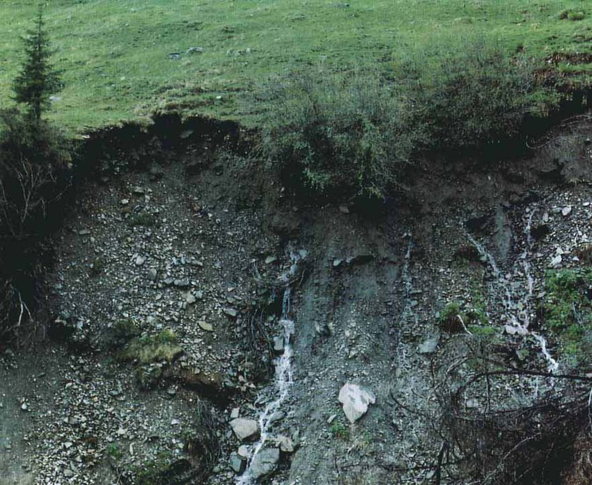
surface as return flow (Dunne, 1978). Figure 7 shows an example of flow along such a high conductivity
layer in a catchment in the Austrian Alps. The location of the springs in Figure 7 indicates that the layer
is parallel to the surface. Heterogeneity at the catchment scale (Figure 6a) may relate to different soil types
and properties. Typically, valley floors show different soils as hillslopes and ridges (Jenny, 1980). At the
regional scale, geology is often dominant through soil formation (parent material) and controls on the
stream network density (von Bandat, 1962; Strahler, 1964).
Similarly, variability in time is present at a range of scales (Figure 6b). At the event scale the shape of the
runoff wave is controlled by the characteristics of the storm and the catchment. At the seasonal scale, runoff
is dominated by physioclimatic characteristics such as the annual cycle in precipitation, snowmelt and eva-
poration. Finally, in the long term, runoff may show the effects of long-term variability of precipitation
(Mandelbrot and Wallis, 1968), climate variability (Schonwiese, 1979), geomorphological processes
(Anderson, 1988) and anthropogenic effects (Gutknecht, 1993).
Types of heterogeneity and variability
The classification of heterogeneity (variability) is useful as it has a major bearing on predictability and
scaling relationships (Morel-Seytoux, 1988). In fact, such a classification may serve as a predictive frame-
work (White, 1988). Here, we will follow the suggestion of Gutknecht (1993), which is consistent with the
definitions of ‘scale’ given earlier (Figure 3).
Hydrological processes may exhibit one or more of the following aspects: (a) discontinuity with discrete
zones (e.g. intermittency of rainfall events; geological zones) - within the zones, the properties are rela-
tively uniform and predictable, whereas there is disparity between the zones; (b) periodicity (e.g. the diurnal
or annual cycle of runoff), which is predictable; and (c) randomness, which is not predictable in detail, but
predictable in terms of statistical properties such as the probability density function.
At this stage it might be useful to define a number of terms related to heterogeneity and variability.
Disorder involves erratic variation in space or time similar to randomness, but it has no probability
aspect. Conversely, order relates to regularity or certain constraints (Allen and Starr, 1982). Structure,
on the other hand, has two meanings. The first, in a general sense, is identical with order (e.g. ‘storm
structure’; Austin and Houze, 1972; geological ‘structural facies’, Anderson, 1989). The second, more
specific, meaning is used in stochastic approaches and refers to the moments of a distribution such as
mean, variance and correlation length (Hoeksema and Kitanidis, 1985). ‘Structural analysis’, forFigure 7. Preferential flow along a high conductivity layer. Lohnersbach catchment in the Austrian Alps. Photo courtesy of R. Kimbauer and P. Haas
SCALE ISSUES 2: A REVIEW OF SCALE ISSUES                                  259

example, attempts to estimate these moments (de Marsily, 1986). Organization is often used in a similar way
to ‘order’, but tends to relate to a more complex form of regularity. Also, it is often closely related to the
function and the formation (genesis) of the system (Denbigh, 1975). These aspects are illustrated in more
detail in the ensuing discussion.
Organization
  Catchments and hydrological processes show organization in many ways, which include the following
examples. (a) Drainage networks embody a ‘deep sense of symmetry’ (Rodriguez-Iturbe, 1986). This prob-
ably reflects some kind of general principle such as minimum energy expenditure (Rodriguez-Iturbe et al.,
1992b) and adaptive landforms (Willgoose et al., 1991). Also, Rodriguez-Iturbe (1986) suggested that
Horton’s laws (Horton, 1945; Strahler, 1957) are a reflection of this organization. (b) Geological facies
(Walker, 1984) are discrete units of different natures which are associated with a specific formational
process (Anderson, 1989; 1991; Miall, 1985). These units are often ‘organized’ in certain sequences. For
example, in a glacial outwash sequence, deposits close to the former ice fronts mostly consist of gravel,
whereas those further away may consist mainly of silt and clay. (c) Austin and Houze (1972) showed
that precipitation patterns are organized in clearly definable units (cells, small mesoscale areas, large mesos-
cale areas, synoptic areas), which may be recognized as they develop, move and dissipate. (d) Soils tend to
develop in response to state factors (i.e. controls) such as topography (Jenny, 1941; 1980). Different units in
a catchment (e.g. ‘nose’, ‘slope’ and ‘hollow’; Hack and Goodlett, 1960; England and Holtan, 1969;
Krasovskaia, 1982) may have a different function and are typically formed by different processes. Soil
catenas (i.e. soil sequences along a slope ) are a common form of organization of soils in catchments
(Milne, 1935; Moore et al., 1993a; Gessler et al., 1993).
Organization versus randomness
   Randomness is essentially the opposite of organization (Dooge, 1986). Given that ‘randomness is the
property that makes statistical calculations come out right’ (Weinberg, 1975: 17) and the high degree of
organization of catchments illustrated in the preceding sections, care must be exercised when using stochas-
tic methods. It is interesting to follow a debate between field and stochastic hydrogeology researchers on
exactly this issue: Dagan (1986) put forward a stochastic theory of groundwater flow and transport and
Neuman (1990) proposed a universal scaling law for hydraulic conductivity, both studies drawing heavily
on the randomness assumption. Two comments prepared by Williams (1988) and Anderson (1991), respec-
tively, criticized this assumption and emphasized the presence of organized discrete units as formed by geo-
logical processes. Specifically, Williams (1988) pointed out that the apparent disorder is largely a
consequence of studying rocks through point measurements such as boreholes. This statement is certainly
also valid in catchment hydrology. It is clear that for ‘enlightened scaling’ (Morel-Seytoux, 1988), the
identification of organization is a key factor. The importance of organization at the hillslope and catch-
ment scale has been exemplified by Bloschl et al. (1993), who simulated runoff hydrographs based on
organized and random spatial patterns of hydrological quantities. Although the covariance structure of
the organized and the random examples were identical, the runoff responses were vastly different. Similar
effects have been shown by Kupfersberger and Bloschl(l995) for groundwater flow. It is also interesting to
note that hydrological processes often show aspects of both organization and randomness (Gutknecht,
1993; Bloschl et al., submitted).

               LINKAGES ACROSS SCALES FROM A MODELLING PERSPECTIVE
Framework
  Earlier in this paper, the term ‘scaling’ was defined as transferring information across scales. What,
precisely, does information mean in this context? Let g{s; 8; i } be some small-scale conceptualization of
hydrological response as a function of state variables s, parameters 8 and inputs i, and let G { S ;0 ;I } be
the corresponding large-scale description. Now, the information scaled consists of state variables, para-
260 G . BLOSCHL AND M . SIVAPALAN
"point" one
small scale
value
distributing singling out
I I I I I I many
pattern or pdf (moments) small scale
values
aggregating
I t
(spatial or temporal) average value
disaggregating
one
large scale
value
Figure 8. Linkages across scales as a two-step procedure
meters and inputs as well as the conceptualization itself
s H S ; 8 ++ 0 ; i H I ; g{s; 8;i} - G { S ; 0 ;I }
However, in practice, often only one piece of information out of this list is scaled and the others are, impli-
(3)
citly, assumed to hold true at either scale. It is clear that this is not always appropriate. Also, the definition
of a large-scale parameter 0 is not always meaningful, even if 8 and 0 share the same name. The same can
be the case for state variables. For example, it may be difficult (if not impossible) to define a large-scale
hydraulic gradient in an unsaturated structured soil.
Upscaling, typically, consists of two steps. For illustration, consider the problem of estimating catchment
rainfall from one rain gauge (or a small number of rain gauges), i.e. upscaling rainfall from a dm2 scale to a
km2 scale. The first step involves distributing the small-scale precipitation over the catchment (e.g. as a func-
tion of topography). The second step consists of aggregating the spatial distribution of rainfall into one
single value (Figure 8). Conversely, downscaling involves disuggreguting and singling out. In some
instances, the two steps are collapsed into one single step, as would be the case of using, say, station
weights in the example of upscaling precipitation. However, in other instances only one of the steps is of
interest. This has led to a very unspecific usage of the term 'upscaling' in published work referring to either
distributing, aggregating, or both. In this paper we will use the terms as defined in Figure 8.
Scaling can be performed either in a deterministic or a stochastic framework. In a deterministic frame-
work, distributing small-scale values results in a spatial (or temporal) pattern which is aggregated into one
'average' value. In a stochastic framework, distributing results in a distribution function (and covariance
function), often characterized by its moments, which is subsequently aggregated. The stochastic approach
has a particular appeal as the detailed pattern is rarely known and distribution functions can be derived
Table I. Examples for linkages across scales. Abbreviations: swe = snow water equivalent
State variables Parameters Inputs Conceptualizations
Distributing Wetness index Kriging conductivities Spline interpolation Distributed model
swe =f(terrain) Soil type mapping of rainfall
Singling out Trivial Trivial Trivial Trivial
-~~ ~ ~
Aggregation Mostly trivial Effective conductivity Trivial Perturbation
=geometric mean approach
Disaggregation Wetness index Mass curves
and satellite data Daily --+ hourly
rainfall
Upscaling in one step Snow index stations Thiessen method
depth-area curves
Downscaling in one step Runoff coefficient
for culvert designSCALE ISSUES 2: A REVIEW OF SCALE ISSUES 26 1 more readily. On the other hand, deterministic methods have more potential to capture the organized nature of catchments, as discussed earlier in this paper. Methods of scaling greatly depend on whether state variables, parameters, inputs or conceptualizations are scaled. Although parameters often need to be scaled in the context of a particular model or theory, inputs and state variables can in many instances be treated independently of the model. Table I gives some examples that are of importance in hydrology. Distributing information is usually addressed by some sort of interpolation scheme such as kriging. Singling out is always trivial as it simply involves select- ing a subset of a detailed spatial (or temporal) pattern that is known. Aggregating information is trivial or mostly trivial for state variables (e.g. soil moisture) and inputs (e.g. rainfall) as the aggregated value results from laws such as the conservation of mass. It is not trivial, however, to aggregate model parameters (e.g. hydraulic conductivity) as the aggregated value depends on the interplay between the model and the model parameters. Disaggregating information is often based on indices such as the wetness index. Methods for upscaling/downscaling in one step are often based on empirical regression relationships. Finally, scaling con- ceptualizations refers to deriving a model structure from a model or theory at another scale. Recall that no scaling is involved for a model that is formulated directly at the scale at which inputs are available and out- puts are required. Some of the examples in Table I are discussed in more detail in the following sections. Distributing information Distributing information over space or time invariantly involves some sort of interpolation. Hydrological measurements are, typically, much coarser spaced in space than in time, so most interpolation schemes refer to the space domain. The classical interpolation problem in hydrology is the spatial estimation of rainfall from rain gauge measurements. A wide variety of methods has been designed, including: the isohyetal method; optimum interpolation/kriging (Matheron, 1973; Journel and Huijbregts, 1978; Deutsch and Journel, 1992); spline interpolation (Creutin and Obled, 1982; Hutchinson, 1991); moving polynomials; inverse distance; and others. The various methods have been compared in Creutin and Obled (1982), Lebel et al. (1987) and Tabios and Salas (1985), and a review is given in Dingman (1994: 120). Other variables required for hydrological modelling include hydraulic conductivity (de Marsily, 1986), climate data (Hutchinson, 1991; Kirnbauer et al., 1994) and elevation data (Moore et al., 1991), for which similar interpolation methods are used. In many instances the supports (i.e. measurements) on which the interpolation is based are too widely spaced and the natural variability in the quantity of interest is too large for reliable estimation. One way to address this problem is to correlate the quantity of interest to an auxiliary variable (i.e. a covariate or surrogate), whose spatial distribution can more readily be measured. The spatial distribution of the quan- tity is then inferred from the spatial distribution of the covariate. In catchment hydrology topography is widely used as a covariate because it is about the only information known in a spatially distributed fashion. Precipitation has a tendency to increase with elevation on an event (Fitzharris, 1975) and seasonal (Lang, 1985) scale, but this is not necessarily so for hourly and shorter scales (Obled, 1990). A number of interpolation schemes have been suggested that explicitly use elevation, ranging from purely statistical (Jensen, 1989) to dynamic (Leavesley and Hay, 1993) approaches. Similarly, snow characteristics, though highly variable at a range of space scales, are often related to terrain (Golding, 1974; Woo et al., 1983a; 1983b). For example, Bloschl et af. (1991) suggested an interpolation procedure based on elevation, slope and curvature. The coefficients relating snow water equivalent to elevation were based on a best fit to snow course data, whereas the other coefficients were derived from qualitative considerations. Topographic information has also been used to estimate the spatial distribution of soil moisture. The topographic wetness index was first developed by Beven and Kirkby (1979) and O’Loughlin (1981) to pre- dict zones of saturation. The wetness index of Beven and Kirkby (1979) is based on four assumptions: 1. The lateral subsurface flow-rate is assumed to be proportional to the local slope tan p of the terrain. This implies kinematic flow, small slopes (tan p x sin p ) and that the water-table is parallel to the topography.
262                                     G . BLOSCHL AND M. SIVAPALAN

2. Hydraulic conductivity is assumed to decrease exponentially with depth and storage deficit is assumed
   to be distributed linearly with depth (Beven, 1986).
3. Recharge is assumed to be spatially uniform.
4. Steady-state conditions are assumed to apply, so the lateral subsurface flow-rate is proportional to the
   recharge and the area a drained per unit contour length at point i.
  Introducing the wetness index wi at point i
                                                          T-a
                                              wi = In(   Ti.
                                                           tanp)                                              (4)

where Tiis the local transmissivity and i= is its average in the basin, gives a simple expression for the storage
deficit Si at point i
                                              Si=S+rn.(it,- Wi)                                                (5)
S and it, are the averages of the storage deficit and the wetness index over the catchment, respectively, and m
is an integral length which can be interpreted as the equivalent soil depth. For a detailed derivation, see
Beven and Kirkby (1979), Beven (1986) and Wood et al. (1988). A similar wetness index has been proposed
by O’Loughlin (1981;1986) which, however, makes no assumption about the shape of hydraulic conductiv-
ity with depth.
   The wetness index wi increases with increasing specific catchment area and decreasing slope gradient.
Hence the value of the index is high in valleys (high specific catchment area and low slope), where water
concentrates, and is low on steep hillslopes (high slope), where water is free to drain. For distributing
the saturation deficit Si over a catchment, Equation (5) can be fitted to a number of point samples. How-
ever, the predicitive power of the wetness index has not yet been fully assessed. Most comparisons with field
data were performed in very small catchments. Moore et al. (1988) found that the wetness index [Equation
(4)] explained 26-33%0 of the spatial variation in soil water content in a 7.5ha catchment in NSW,
Australia, whereas a study in a 38ha catchment in Kansas (Ladson and Moore, 1992) suggested an
explained variation of less than 10%. Burt and Butcher (1985) found that the wetness index explained
 17-31% of the variation in the depth to saturation on a 1.4ha hillslope in south Devon, UK. There
also seems to be a dependence of the wetness index on the grid size used for its calculation, which may
become important when using the wetness index in larger catchments (Moore et a/., 1993b; Vertessy and
Band, 1993; Band and Moore, 1995).
   A range of wetness indices has been suggested which attempts to overcome some of the limitations of
Equation (4). For example, Barling et al. (1994) developed a quasi dynamic wetness index that accounts
for variable drainage times since a prior rainfall event. This relaxes the steady-state assumption. Other
developments include the effect of evaporation as controlled by solar radiation (e.g. Moore er al.,
 1993~).A comprehensive review is given in Moore et al. (1991). Based on the rationale that in many land-
scapes pedogenesis of the soil catena (Milne, 1935) occurs in response to the way water moves through the
landscape (Jenny, 1941; 1980; Hoosbeek and Bryant, 1992), terrain indices have also been used to predict
soil attributes (McKenzie and Austin, 1993). For example, Moore et al. (1993a) predicted quantities such as
A horizon thickness and sand content on a 5.4 ha toposequence in Colorado where the explained variances
were about 30%. Gessler et al. (1993) reported a similar study in south-east Australia.
   There is a range of other covariates in use for distributing hydrological information across catchments.
 Soil type or particle size distributions are the traditional indices to distribute soil hydraulic properties
 (Rawls et al., 1983; Benecke, 1992; Williams et al., 1992). General purpose soil maps are widely available
 in considerable detail, such as the STATSGO database developed by the US Department of Agriculture
 (Reybold and TeSelle, 1989). Unfortunately, the variation of soil parameters (such as hydraulic conductiv-
ity) within a particular soil class is often much larger than variations between different soils (Rawls et al.,
 1983; McKenzie and MacLeod, 1989). Part of the problem is that the spatial scale of variation of hydraulic
properties tends to be much smaller (
SCALE ISSUES 2: A REVIEW OF SCALE ISSUES 263 the relationship between the electrical and hydraulic properties of aquifers. For example, an increased clay content tends to decrease both the electrical resistivity and hydraulic conductivity. Kupfersberger and Bloschl ( 1995) showed that auxiliary (geophysical) data are particularly useful for identifying high hydrau- lic conductivity zones such as buried stream channels. There is also a range of indices supporting the inter- polation of information related to vegetation. For example, Hatton and Wu (1995) used the leaf area index (LAI) for interpolating measurements of tree water use. Further covariates include satellite data, particu- larly for the spatial estimation of precipitation, snow properties, evapotranspiration and soil moisture (Engman and Gurney, 1991). However, a full review of this is beyond the scope of this paper. An exciting new area is that of using indicators (Journel, 1986) to spatially distribute information. Indicators are binary variables which are often more consistent with the presence of zones of uniform properties (e.g. clay lenses or geological zones at a larger scale) than the ubiquitous log-normal distribu- tions (Hoeksema and Kitanidis, 1985). They are also more consistent with the type and amount of infor- mation usually available. Indicator-based methods have been used to estimate conductivity in aquifers (Brannan and Haselow, 1993; Kupfersberger, 1994) and they have also been used to interpolate rainfall fields (Barancourt et af.,1992). In the rainfall example, the binary patterns represent areas of rainfall/no rainfall. Aggregating model parameters The study of the aggregation of model parameters involves two questions. (a) Can the microscale equations be used to describe processes at the macroscale? (b) If so, what is the aggregation rule to obtain the macroscale model parameters with the detailed pattern or distribution of the microscale parameters given. The macroscale parameters for use in the microscale equations are termed effective parameters. Specifi- cally, an effective parameter refers to a single parameter value assigned to all points within a model domain (or part of the domain) such that the model based on the uniform parameter field will yield the same output as the model based on the heterogeneous parameter field (Mackay and Riley, 1991). Methods to address the questions (a) and (b) make use of this definition by matching the outputs of the uniform and heterogeneous systems. If an adequate match can be obtained, an effective parameter exists. The aggregation rule is then derived by relating the effective parameter to the underlying heterogeneous distribution. Methods used include analytical approaches (e.g. Gutjahr et al., 1978), Monte Carlo simulations (e.g. Binley et af., 1989) and measurements (e.g. Wu et al., 1982). Effective parameters are of clear practical importance in distributed modelling, but aggregation rules are of more conceptual rather than of practical importance, either in a deterministic or a stochastic framework. In a deterministic framework, the aggregation rule yields an effective parameter over a certain domain with the pattern of the detailed parameter given. How- ever, in practical applications there is rarely enough information on the detailed pattern available to use the aggregation rule in a useful way. In a stochastic framework, the aggregation rule yields the spatial moments of the effective parameter with the spatial moments of the microscale parameter given. This has been used to determine element spacings or target accuracy for calibration (Gelhar, 1986), but in practice other considerations such as data availability are often more important. Another limitation is the assumption of disordered media properties on which such approaches are often based (e.g. Rubin and Gomez- Hernandez, 1990). If some sort of organization is present (e.g. preferential flow; Silliman and Wright, 1988), the same aggregation rules cannot be expected to hold. What follows is a review of effective parameters and aggregation rules for a number of processes that are of importance in catchment hydrology. These include saturated flow, unsaturated flow, infiltration and overland flow. The concept of effective hydraulic conductivity has been widely studied for saturated flow. Consider, in a deterministic approach, uniform (parallel flow lines) two-dimensional steady saturated flow through a block of porous medium made up of smaller blocks of different conductivities. It is easy to show that for an arrangement of blocks in series the effective conductivity equals the harmonic mean of the block values. Similarly, for an arrangement of blocks in parallel, the effective conductivity equals the arithmetic mean. In a stochastic approach, the following results were found for steady saturated flow in an infinite domain without sinks (i.e. uniform flow).
264                                    G . BLOSCHL AND   M. SIVAPALAN

   (a) Whatever the spatial correlation and distribution function of conductivity and whatever the number
of dimensions of the space, the average conductivity always ranges between the harmonic mean and the
arithmetic mean of the local conductivities (Matheron, 1967, cited in de Marsily, 1986). Specifically, for
the one-dimensional case, the effective conductivity Keffequals the harmonic mean K H as it is equivalent
to an arrangement of blocks in series
                                     One-dimensional :      Keff= KH                                  (6)
  (b) If the probability density function of the conductivity is log-normal (and for any isotropic spatial
correlation), Matheron (1967) and Gelhar (1986) showed that for the two-dimensional case the effective
conductivity Ken equals the geometric mean KG.
                                  Two-dimensional:       Ken = KG                                    (7)
  Matheron also made the conjecture that for the three-dimensional case the effective conductivity Ken is

                              Three-dimensional:                   -
                                                        Keff= KG e ~ p ( a ? " ~ / 6 )                       (8)
where o:nKis the variance of In K . This result is strongly supported by the findings of Dykaar and Kitanidis
(1992) using a numerical spectral approach. Dykaar and Kitanidis (1992) also suggested that Equation (8)
is more accurate than the small perturbation method (Gutjahr et al., 1978) and the imbedding matrix
method (Dagan, 1979) when the variances a?nKare large.
   (c) If the probability distribution function is not log-normal (e.g. bimodal), both the numerical spectral
approach and the imbedding matrix method seem to provide good results, whereas the small perturbation
method is not applicable (Dykaar and Kitanidis, 1992).
   Unfortunately, steady-state conditions and uniform flow are not always good assumptions (Rubin and
Gbmez-Hernandez, 1990). For transient conditions, generally, no effective conductivities independent of
time may be defined (Freeze, 1975; El-Kadi and Brutsaert, 1985). Similarly, for bounded domains and
flow systems involving well discharges the effective conductivity is dependent on pumping rates and bound-
ary conditions (Gomez-Hernandez and Gorelick, 1989; Ababou and Wood, 1990; Neuman and Orr, 1993).
It is interesting to note that the effective conductivity tends to increase with increasing dimension of the
system for a given distribution of conductivity. This is consistent with intuitive reasoning: the higher the
dimension the more degrees of freedom are available from which flow can 'choose' the path of lowest resis-
tance. Hence, for a higher dimension, flow is more likely to encounter a low resistance path which tends to
increase the effective conductivity.
   For unsaturated flow in porous media, generally, there exists no effective conductivity that is a property
of the medium only (Russo, 1992). Yeh et al. (1985) suggested that the geometric mean is a suitable effective
parameter for certain conditions, but Mantoglou and Gelhar (1987) showed that the effective conductivity
is heavily dependent on a number of variables such as the capillary tension head. In their examples, an
increase in the capillary tension head from 0 to 175cm translated into a decrease in the effective con-
ductivity of up to 10 orders of magnitude. Mantoglou and Gelhar (1987) also demonstrated significant
hysteresis in the effective values. Such hysteresis was produced by the soil spatial variability rather than
the hysteresis of the local parameter values.
   Similarly to unsaturated flow, for infiltration there is no single effective conductivity in the general case.
However, for very simple conditions, effective parameters may exist. Specifically, for ponded infiltration
(i.e. all the water the soil can infiltrate is available at the surface) Rogers (1992) found the geometric
mean of the conductivity to be an effective value using either the Green and Ampt (1911) or the Philip's
(1957) method. This is based on the assumption of a log-normal spatial distribution of hydraulic conduc-
tivity. For non-zero time to ponding, Sivapalan and Wood (1986), using Philip's (1957) equation, showed
that effective parameters do not exist, i.e. the point infiltration equation does no longer hold true for
spatially variable conductivity.
   Overland flow is also a nonlinear process so, strictly speaking, no effective parameter exists for the
general case. However, Wu et al. (1978; 1982) showed that reasonable approximations do exist for certain
cases. Wu et al. investigated the effect of the spatial variability of roughness on the runoff hydrographs for
SCALE ISSUES 2: A REVIEW OF SCALE ISSUES 265 an experimental watershed facility surfaced with patches or strips of butyl rubber and gravel. Wu et al. concluded that an effective roughness is more likely to exist for a low contrast of roughnesses, for a direc- tion of strips normal to the flow direction and for a large number of strips. They also suggested that the approximate effective roughness can be estimated by equating the steady-state surface water storage on the hypothetical uniform watershed to that on the non-uniform watershed. In a similar analysis, Engman (1986) calculated effective values of Manning’s n for plots of various surface covers based on observations of the outflow hydrograph. Abrahams et al. (1989) measured distribution functions of flow depths and related them to the mean flow depth. All these studies analysed a single process only. If a number of processes are important, it may be pos- sible to define approximate effective parameters, but their relationship with the underlying distribution is not always clear. Binley et al. (1989) analysed, by simulation, three-dimensional saturated-unsaturated flow and surface runoff on a hillslope. For high-conductivity soils, they found effective parameters to rea- sonably reproduce the hillslope hydrograph, although there was no consistent relationship between the effective values and the moments of the spatial distributions. For low-conductivity soils, characterized by surface flow domination of the runoff hydrograph, single effective parameters were not found to be cap- able of reproducing both subsurface and surface flow responses. At a much larger scale, Milly and Eagleson (1987) investigated the effect of soil variability on the annual water balance. Using Eagleson’s (1978) model they concluded that an equivalent homogeneous soil can be defined for sufficiently small variance of the soil parameters. The use of effective parameters in microscale equations for representing processes at the macroscale has a number of limitations. These are particularly severe when the dominant processes change with scale (Beven, 1991). Often the dominant processes change from matrix flow to preferential flow when moving to a larger scale. Although it may be possible to find effective values so that the matrix flow equation produces the same output as the preferential flow system, it does so for the wrong reasons and may therefore not be very reliable. A similar example is the changing relative importance of hillslope processes and channel pro- cesses with increasing catchment size. Ideally, the equations should be directly derived at the macroscale rather than using effective parameters. However, until adequate relationships are available, effective para- meters will still be used. Disaggregating state variables and inputs The purpose of disaggregation is, given the average value over a certain domain, to derive the detailed pattern within that domain. Owing to a lack of information for a particular situation, the disaggregation scheme is often based on stochastic approaches. Here, two examples are reviewed. The first refers to dis- aggregating soil moisture in the space domain and the second refers to disaggregating precipitation in the time domain. Disaggregating soil moisture may be required for estimating the spatial pattern of the water balance as needed for many forms of land management. The input to the disaggregation procedure is usually a large- scale ‘average’ soil moisture. This can be the pixel soil moisture based on satellite data, an estimate from a large-scale atmospheric model or an estimate derived from a catchment water balance. One problem with this ‘average’ soil moisture value is that the type of averaging is often not clearly defined. Nor does it neces- sarily represent a good estimate for the ‘true’ average value in a mass balance sense. Although the associ- ated bias is often neglected, there is a substantial research effort underway to address the problem. One example is the First International Satellite Land Surface Climatology Project (ISLSCP) Field Experiment (FIFE) (Sellers et al., 1992). Guerra et al. (1993) derived a simple disaggregation scheme for soil moisture and evaporation. The scheme is based on the wetness index and additionally accounts for the effects of spatially variable radiation and vegetation. It is important to note that the wetness index [Equation (4)] along with Equation (5) can be used for both disaggregating and distributing soil moisture. Equation (5) can, in fact, be interpreted as a disaggregation operator (Sivapalan, 1993), yielding the spatial pattern of saturation deficit with the areal average of saturation deficit given. In a similar application, Sivapalan and Viney (1994a,b) disaggregated soil moisture stores from the 39 km2 Conjurunup catchment in Western Australia to 1-5 km2 subcatchments, based on topographic and land use characteristics. Sivapalan and
266                                    G . BLOSCHL AND M . SIVAPALAN

Viney ( 1994a,b) tested the procedure by comparing simulated and observed runoff for individual subcatch-
ments.
   Disaggregating precipitation in time is mainly needed for design purposes. Specifically, disaggregation
schemes derive the temporal pattern of precipitation within a storm, with the average intensity and storm
duration given. The importance of the time distribution of rainfall for runoff simulations has, for example,
been shown by Woolhiser and Goodrich (1988). Mass curves are probably the most widely used concept for
disaggregating storms. Mass curves are plots of cumulative storm depths (normalized by total storm depth)
versus cumulative time since the beginning of a storm (normalized by the storm duration). The concept is
based on the recognition that, for a particular location and a particular season, storms often exhibit simi-
larities in their internal structure despite their different durations and total storm depths. The time distri-
bution depends on the storm type and climate (Huff, 1967). For example, for non-tropical storms in the
USA maximum intensities have been shown to occur at about one-third of the storm duration into the
storm, whereas for tropical storms they occurred at about one-half of the storm duration (Wenzel, 1982;
USDA-SCS, 1986). Mass curves have recently been put into the context of the scaling behaviour of preci-
pitation (Koutsoyiannis and Foufoula-Georgiou, 1993). A similar method has been developed by Pilgrim
and Cordery (1975), which is a standard method in Australian design (Pilgrim, 1987). A number of more
sophisticated disaggregation schemes (i.e. stochastic rainfall models) have been reported (e.g. Woolhiser
and Osborne, 1985) based on the eary work of Pattison (1965) and Grace and Eagleson (1966). A review
is given in Foufoula-Georgiou and Georgakakos (1991).
   Another application of disaggregating temporal rainfall is to derive the statistical properties of hourly
rainfall from those of daily rainfall. The need for such a disaggregation stems from the fact that the number
of pluviometers in a given region is always much smaller than that of daily read rain gauges. Relationships
between hourly and daily rainfall are often based on multiple regression equations (Canterford et al., 1987).

Upldownscaling in one step
   There are a number of methods in use for up/downscaling that do not explicitly estimate a spatial (or
temporal) distribution. This means that these methods make some implicit assumption about the distribu-
tion and skip the intermediate step in Figure 1. An example is the Thiessen (191 I) method for estimating
catchment rainfall. It assumes that at any point in the watershed the rainfall is the same as that at the near-
est gauge. The catchment rainfall is determined by a linear combination of the station rainfalls and the
station weights are derived from a Thiessen polygon network. Another example is depth-area-duration
curves. These are relationships that represent the average rainfall over a given area and for a given time
interval and are derived by analysing the isohyetal patterns for a particular storm (WMO, 1969; Linsley
et al., 1988). Depth-area-duration curves are scaling relationships as they allow the transfer of informa-
tion (average precipitation) across space scales (catchment sizes) or time-scales (time intervals).
   If recurrence intervals or return periods (Gumbel, 1941) are included in the definition of scale, the wide
area of hydrological statistics relates to scale relationships. Up/downscaling then refers to the transfer of
information (e.g. flood peaks) across time-scales (recurrence intervals).
Linking conceptualizations
  Linking conceptualizations across scales can follow either an upward or a downward route (KlemeS,
1983). The upward approach attempts to combine, by mathematical synthesis, the empirical facts and
theoretical knowledge available at a lower level of scale into theories capable of predicting processes at
a higher level. Eagleson (1972) pioneered this approach in the context of flood frequency analysis. This
route has a great appeal because it is theoretically straightforward and appears conceptually clear. KlemeS
(1983), however, warned that this clarity can be deceptive and that the approach is severely limited by our
incomplete knowledge and the constraints of mathematical tractability (Dooge, 1982; 1986). A well-known
example is that of upscaling Darcy’s law (a matrix flow assumption), which can be misleading when macro-
pore flow becomes important (White, 1988; Beven, 1991). KlemeS (1983) therefore suggested adopting the
downward approach, which strives to find a concept directly at the level of interest (or higher) and then
looks for the steps that could have led to it from a lower level. It is clear that the ‘depth of inference’ (i.e.
You can also read