Scotland's North Coast 500 B-Line - Saving the small things that run the planet - Buglife
←
→
Page content transcription
If your browser does not render page correctly, please read the page content below
© North Coast 500 Limited
)

Scotland’s North Coast 500 B-Line

            Saving the small things that run the planet
Summary

The North Coast 500 (NC500) is one of world’s most iconic coastal touring routes, it has opened the
North Highlands and its beautiful, but fragile, landscapes to billions of visitors to explore and enjoy
every year. Since it opened in 2015, the NC500 achieved a 3.3 billion global audience reach, but with
such huge visitor numbers, it is now on the verge of becoming a victim of its own success.

Several critically endangered plants are found on the North Coast that are currently under threat.
Similarly, the Great yellow bumblebee nests and breeds near the NC500 but is also at risk of extinction,
and there are other pollinating insects which rely on the wildflower-rich habitats found along roadside
verges and in the local area. The popularity of the NC500 has also created many other visitor
management impacts for Highland communities. New landscape viewing areas, stopping points and
carparks are needed to maintain the visitor experience and to create space for increased car and
motorhome use. If managed with nature in mind, this new infrastructure could also provide
opportunities to make space for pollinating insects around the NC500. We present an opportunity to
enhance the visitor experience and support nature’s recovery.

Much of the Highland NC500 is on Buglife’s ’B-Line‘. To identify areas which would most benefit from
improved management for both increasing visitor numbers and to increase habitat for pollinators, this
report has been produced with input from project partners (Highland Council, Plantlife Scotland and
the Bumblebee Conservation Trust) and provides recommendations for managing greenspaces and
visitor infrastructure in a pollinator friendly way.

We have provided detailed mapping via GIS to enable Highland Council to maximize these
opportunities. We hope this report is seen as an exemplar model for auditing road verges and laybys
along tourist trails and provides some best practice case studies where infrastructure improvements
can have maximum benefits for pollinators and people. We also provide advice on managing roadside
verges for pollinators and on reducing pesticide use, which can be used to improve the long-term
sustainability and environmental performance of the route.

                                                   1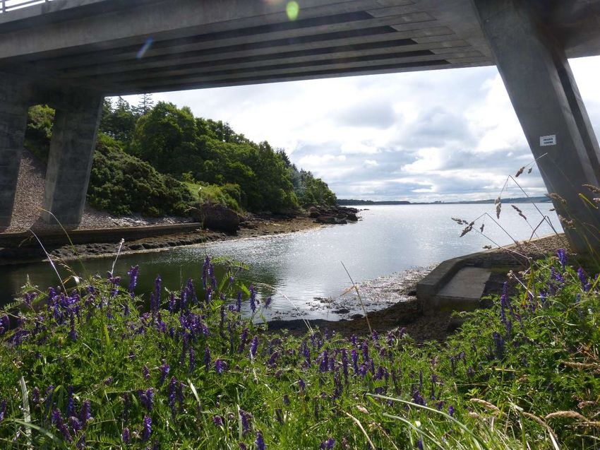
Contents

    1. Introduction: The North Coast 500 & B-Lines………………………………………………………………..……3
            a. Challenges faced by Highland Council around the NC500………………………………….…..4
            b. How do road verges support pollinators?..................................................................6
            c. Is traffic collision a problem for pollinators along the NC500?..................................6
           d. Is vehicle pollution a problem for pollinators on the NC500?....................................7
            e. Natural heritage along the NC500………………………………………………………………………….7
                       i. Great Yellow Bumblebee (Bombus distinguendus)…………………………………….7
                     ii. Other pollinators……………………………………………………………………………………….7
                    iii. Threatened and rare plants ………………………………………………………………………7
                     iv. Designated sites, National and Local Nature reserves……………………………….8
    2. Creating B-Lines across Scotland………………………………………………………………………………………..8
            a. B-Lines Mapping Guiding Principles……………………………………………………………………….8
            b. B-Lines Mapping methodology…………………………………………………………………………….10
    3. How we collected datasets for this project…………………………………………………………………….…11
    4. Outputs…………………………………………………………………………………………………………………………….13
            a. Maps……………………………………………………………………………………………………………………14
             b. Tables………………………………………………………………………………………………………………….17
     5. Discussion & recommendations……………………………………………………………………………………….22
            a. Managing NC500 verges for pollinators……………………………………………………………….22
            b. The size and shape of grasslands around laybys and carparks……………………………..26
            c. Seeding and planting around visitor infrastructure………………………………………………26
                        i. Yellow rattle……………………………………………………………………………………………26
                      ii. Eyebright as secondary root hemiparasite………………………………………………27
                    iii. Short sward seed mixes…………………………………………………………………………..27
                    iv. Great yellow bumblebee seed mixes……………………………………………………….28
                    v. Hedging & nectar rich trees……………………………………………………………………..29
           d. Reducing pesticide use along the NC500………………………………………………………………29
           e. Ideas for carparks and layby design………………………………………………………………………30
           f. Managing larger sites for pollinators…………………………………………………………………….34
           g. NC500 CASE STUDIES ………………………………………………………………………………………..…35
                      i. Site One: Dunnet Bay car parks………………………………………………………………..35
                     ii. Site Two: Loch Fleet NNR…………………………………………………………………………38
                    iii. Site Three: Balnakeil Beach car park………………………………………………………..42
                    iv. Site Four: Bettyhill to Melvich fencing and passing places……………………….45
                     v. Site Five: Gorstan and Garve woodland pollinator corridor……………………..48
                    vi. Site Six: John o’Groats meadow and people engagement………………………..51
                   vii. Site Seven: A9 verges and layby mowing regimes…………………………………….54
           h. Skills development needs.…………………………………………………………………………………….55
           i. Benefits of pollinator habitats for people……………………………………………………………..56
           j. Reflection on the methodology.……………………………………………………………………………57
           k. Opportunities through grant funding……………………………………………………………………58
           l. Links to other projects………………………………………………………………………………………….60
    6. Acknowledgements…………………………………………………………………………………………………………..61
    7. Appendices……………………………………………………………………………………………………………………….62
           a. Table 3: Carparks and Laybys within the B-Line…………………………………………………….62
           b. Maps…………………………………………………………………………………………………………………….73

                                                          2
Introduction: The North Coast 500 and B-Lines

The North Coast 500 (NC500) route launched in 2015 and covers a 516 mile route around Scotland’s
most northerly mainland coastline. It starts and finishes at Inverness Castle, a key visitor site in the
city of Inverness. Year on year visitor numbers to this part of Scotland are increasing dramatically, this
has been exacerbated during 2020, and is expected to be again during 2021, due to the rise in
staycations following COVID restrictions. Whilst high visitor numbers can be beneficial for local
tourism businesses who are trying to recover from the impacts of the pandemic, it can be challenging
for local communities and Highland Council who need to manage and mitigate any negative visitor
impacts.

As well as facing the COVID pandemic we are also in a climate and biodiversity crisis. Our precious
pollinators are disappearing from large parts of the countryside – there are fewer bees, hoverflies,
butterflies and moths – and as well as the loss of abundance, some species are at risk of extinction in
Scotland. We can change this, by working together to restore wildflower areas in our countryside and
urban areas we can aid nature’s recovery. Buglife, supported by partner organisations, realised there
was scope to develop a project, combining our B-lines with the NC500 tourist route; to investigate the
impacts of visitors on pollinators and explore solutions for enhancing infrastructure in a way that
improves visitor experience and supports nature’s recovery.

B-Lines are our response to the decline of bees and other pollinating insects, a plan for how to
reconnect our wild places by creating a network of wildflowers across our landscapes.

B-Lines provide an opportunity to create a network of wildflower-rich areas across Scotland providing
essential routes for pollinators to use. The B-Lines network in Scotland includes our best habitats and
identifies key areas to restore and create new wildflower-rich meadows, important grassland verges
and pollinator friendly gardens. B-Lines can be adopted by farmers and landowners, local authorities
and the general public across all of Scotland. An NC500 B-Line would contribute to the Scottish
Pollinator Strategy, part of the Scottish Biodiversity Strategy, and towards actions identified within
the Highland Local Biodiversity Action Plan.

The first step developing any B-Line project is a mapping exercise to record existing key and beneficial
pollinator habitats and using this information to highlight opportunities for habitat creation. Buglife
developed this methodology as part of our B-Lines work and have successfully used it to inform
projects throughout the UK. In Scotland, Buglife have been leading B-Lines work across the central
belt and we are delighted to now be able to extend this work into rural Scotland.
                                                                                                             ©Natalie Stevenson

Tongue, North West Sutherland

                                                    3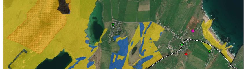
Along the NC500 there are: 405 laybys and carparks; 27 places of worship and cemeteries; 112
Scheduled monuments, 5,268 Canmore historical points; 10 archaeological conservation areas and
13 train stations. This exemplifies the diversity of historical and cultural assets in the Highlands,
alongside its unique biological and geological importance. We have also considered the location of
nearby greenspace, such as golf courses and public parks as we have worked along this route.
Challenges faced by Highland Council around the NC500
From Highland Council’s Draft Visitor Management Plan (2021):
Roads, parking and transport issues:
Insufficient capacity on some narrow rural and single-track roads to cope with large
numbers of vehicles; large motorhomes/campervans causing congestion
Insufficient parking provision in tourist hotspots leading to safety issues - parking
congestion, obstruction of the carriageway, and inappropriate use of laybys
Parking overnight in non-designated areas
Parking on soft verges causing damage to verge and road edges
Community tolerance of large visitor volumes and behavior leading to inappropriate
responses e.g. erection of signage, barriers across some public roads, introduction of
roadside hazards such as placement of boulders/rubble/logs on the verge or in lay-bys
Amenity and waste issues:
Lack of awareness of Council operated public convenience facilities and Comfort Schemes
available
Inappropriate use of public toilets; disposal of chemical waste, increased water
consumption due to topping up of motorhome containers
Lack of suitable motorhome waste disposal facilities
Existing bin volume / numbers in key locations not coping with high volumes of waste
Littering and other unauthorised waste disposal issues
Outdoor access issues:
Informal camping and associated anti-social issues; fires, litter, toilet, noise, overuse and
congregating
Landowners and communities trying their own solutions which can disperse the problem
to other sites – including non-compliant signs or obstructions
Lack of awareness of the Scottish Outdoor Access Code by newcomers to the countryside
Increased pressure and erosion on some popular paths
Limited numbers of Countryside Rangers available to provide advice and guidance or
monitor visitor hotspot pressures
Environmental and public health issues:
Informal camping leading to public health issues with human waste
Outdoor toileting and risk to private water supplies
Investigating fly-tipping and taking enforcement action
Public information:
Limited promotion of some key services e.g. locations of public toilets or motorhome
waste facilities
Dissemination of unhelpful and sometimes inaccurate information – particularly on social
media
4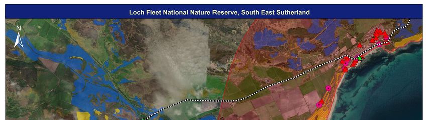
Figure 1: From Observations from the west: Visitors, access and wild camping: Cecilie Dohm,
John Muir Trust

Last summer, after a quiet spring due to Lockdown, Covid-19 travel restrictions caused large
numbers of people to holiday in the UK. Many campsites remained closed or offered restricted
capacity which in many cases amplified the tourism volume issue and created widespread
problems.

Highland Council is not clear at this stage what impact Covid-19 will have on visitors in 2021.
However, they expect visitor numbers to the Highlands to remain high as they have been
increasing steadily over the past decade and there will likely be an increase in certain types of
tourism as a result of the virus, e.g., campervan/motorhomes, informal camping, short breaks
and day trippers.

The Highlands is also now seen as a safe place to visit and as such numbers are likely to continue
to rise. There may also be Brexit impacts which could make ‘staycationing’ even more popular.
These visitors will therefore continue to impact on the services that The Highland Council
provides and on the communities along the NC500.

Across Scotland, 50% of visits are undertaken for the enjoyment of scenery or landscapes. Within
the Highland Council area this is raised to 87% (Colin Simpson, Principal Officer - Europe, Tourism
& Film, Highland Council, pers. comm.). This means that for a good visitor experience to be
maintained it is essential that the special scenery and landscapes that motivate people to visit
are undamaged and kept in a thriving condition.

Highland Council members agreed that the Council declare a climate and ecological emergency
in May 2019. The Council is keen to develop cross departmental and partnership work to address
this emergency. Highland Council currently has a Biodiversity Action Plan and would be really
supportive of the development of a NC500 B-Line as an approach to addressing both visitor
management and biodiversity issues together (Nicole Wallace, Acting Head of Planning and
Environment, Highland Council, pers. comm.).

                                                5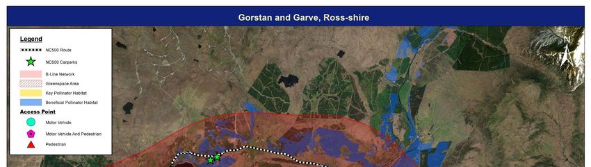
© Claire Pumfrey
Bumblebee on Scabious

How do road verges support pollinators?

Road verges have been shown to contain significant numbers and species of pollinators, and they
can support similar pollinator communities to other surrounding habitats (Villemey et al., 2018).
Rare species can be found along road verges (Heneberg et al. 2017; Raemakers et al. 2001), and
some species are completely dependent upon road verges in otherwise unsuitable landscapes
(Heneberg et al., 2017). A study in Ayrshire, Scotland found that butterfly, bee and hoverfly
abundances, diversity and species richness were greater in road verges than in many other
habitats, including arable farmland, intensive and rough grassland, woodland, hedgerows and
open scrub (Cole et al., 2017). Road verges can provide beneficial habitats within the agricultural
landscape, with bumblebee abundance found to be higher along road verges compared to the
field margins of conventionally managed arable fields (Hanley and Wilkins, 2015). Pollinators have
been recorded along road verges of many different types and sizes from rural roads to highways
(Free et al., 1975; Ouin et al., 2004; Villemey et al., 2018).

Is traffic collision a problem for pollinators along the NC500?

Traffic on roads can be a cause of pollinator mortality through direct collisions (Muñoz et al., 2015).
One study found that around 71% of the more than 100,000 dead invertebrates found along a 90 km/h
highway with moderate daily traffic rates (average of 9,700 vehicles/day during summer) were
pollinators (Lepidoptera and Hymenoptera; excluding Diptera from 2013 due to abnormally high
abundances) (Baxter-Gilbert et al., 2015). For Lepidoptera this equated to 10.1 individuals/km/day
and for Hymenoptera it was more than double with 26.8 individuals/km/day being killed.

Aside from the A9, the NC500 is predominantly small roads, often single track. As a result, the speed
of vehicles will be dramatically reduced. Despite the vast number of visitors to the NC500 the overall

                                                  6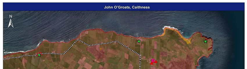
volume of traffic is significantly less than would be seen in an urban area or on a motorway for
example. For this reason, we don’t believe that traffic collision would be the main threat for pollinators
along this route in the Highlands. Far greater risks are likely to come from habitat loss or damage
(which could be caused by vehicles parking on road verges), unfavorable land management,
construction and development and climate change.

Is vehicle pollution a problem for pollinators on the NC500?

Roads and road traffic are a major source of pollution that may affect road verges in a number of ways
(Forman and Alexander, 1998). Lead, zinc, cadmium, copper, nickel, manganese and chromium are
the main heavy metal pollutants along roads. Lead is becoming less important, as lead petrol was
replaced with unleaded (Löfgren and Hammar, 2000), however it is still present. Other heavy metal
pollutants arise from the wear and tear of car parts such as tyres, brake linings, motor oil and the road
surface itself. These can impact pollinators both at the adult and the larval stages, as foragers can
experience behavioural and reproductive changes when consuming contaminated nectar and pollen,
larvae foraging on contaminated leaves experience greater mortalities, and ground-nesting bees also
have the potential to be adversely affected.
Along roadsides (and around laybys and carparks) nitrogen deposition from exhaust fumes can also
cause nutrient enrichment. This can be a particular problem for verge management, resulting in rank
vegetation such as docks and nettles if not managed correctly.
Along the NC500 pollutants will be less due to the smaller vehicle numbers than, for example,
alongside a motorway or urban road. Beside laybys and carparks however there may be a localized
pollution effect if visitors regularly stop but keep their vehicle engines running.

Natural heritage along the NC500
Great yellow bumblebee (Bombus distinguendus)
One of the rarest British bumblebees, now restricted to machair and other flower-rich areas in the
Orkneys, Scottish islands, and Caithness and Sutherland. A large species, the abdomen and thorax are
entirely covered with sandy-yellow hairs, with the exception of a black band across the thorax
between the wing bases. This species appears to have a particular association with Red clover
(Trifolium pratense) (Bumblebee Conservation Trust, 2020).
Other pollinators
Some other important pollinators that are found along the NC500 include the Northern brown argus
butterfly (Aricia artaxerxes), Small blue butterfly (Cupido minimus), Moss carder bumblebee (Bombus
muscorum) and the Northern colletes mining bee (Colletes floralis). Many other species of pollinating
insects, including moths, hoverflies and flies also make up the special biodiversity along this route,
each of them important and part of an essential ecosystem. These four species have been mentioned
specifically however due to their links to current projects being undertaken by Buglife, Butterfly
Conservation and the Bumblebee Conservation Trust in the Highlands.

Threatened and rare plants along the NC500

Purple Oxytropis (Oxytropis lambertii) -This nationally rare species is dependent on good management
and is vulnerable to scrub encroachment and over-grazing.

Scottish Biodiversity List listed Eyebrights - The area is home to two endangered species of eyebrights
(Euphrasia rotundifolia and E. marshalii) as well as a range of other species and hybrids.

                                                    7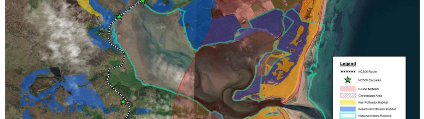
Scottish Primrose (Primula scotica) - A rare, delicate perennial wildflower found in the wild only in
northern Scotland. It has tiny, yellow-centered, burgundy flowers.
Designated sites, National and Local Nature reserves
There are many designated sites within this area including many Sites of Special Scientific Interest that
helped inform our B-Lines, one Biosphere reserve, one Geopark and one potential UNESCO World
Heritage Site.
Merkinch Local Nature Reserve (LNR) is the only Local Nature Reserve in the Highlands. On the east
coast you can find Loch Fleet National Nature Reserve (NNR), on the west coast, Beinn Eighe and Loch
Maree Islands NNR, and Knockan Crag NNR. In the north, Forsinard Flows NNR, and just outside
Inverness Ben Wyvis NNR.
Munsary Nature Reserve is a peatland site owned and managed by Plantlife, and the Scottish Wildlife
Trust has five reserves around this region (Belmaduthy Dam, Talich, Loch Fleet, Ben Mor Coigach, and
Handa Island). Other environmental NGOs such as the John Muir Trust and RSPB Scotland are also
working at large sites around the NC500.
Forest and Land Scotland, and local community trusts, both own and manage woodlands along the
NC500.
From a Buglife perspective we have identified seven Important Invertebrate Areas (IIAs) close to the
NC500. These are nationally or internationally significant places for the conservation of invertebrates
and the habitats upon which they rely (https://www.buglife.org.uk/our-work/important-invertebrate-
areas/).
Assynt Coigach IIA
Strathnaver IIA
Wester Ross IIA
Kyle of Sutherland Rivers IIA
Dornoch Firth IIA
East Ross and Cromarty IIA
East Inverness-shire IIA
Creating B-Lines across Scotland
B-Lines Mapping Guiding Principles
B-Lines is a mapping exercise that links existing areas of important habitat, e.g. Sites of Special
Scientific Interest, alongside smaller-scale features for pollinators. B-Lines is a Buglife initiative, and
we are working with partners and encouraging others to get involved for the benefit of all pollinators
and other wildlife.
The B-Lines maps provide a framework within which to promote increased, strategically located
wildflower-rich habitat restoration/creation alongside other targeted pollinator habitat measures.
The mapped B-Lines network also provides a framework for prioritizing the development of new, or
extension of existing projects and delivery programs. The identification of the B-Lines paves the way
for further promotion of the initiative and for integrating delivery activities with other partners. It also
provides increased emphasis on particular parts of the landscape, now recognized as part of the UK-
wide B-Lines network.
8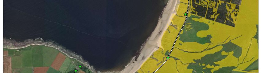
The effectiveness of B-Lines is dependent on maintaining the integrity of its vision across a large
geographic area and many individual delivery partnerships. The following simple guiding principles
have therefore been produced to help partners deliver B-Lines in a reasonably consistent manner.

    1) B-Lines should be identified as 3 km wide linear zones within which the aim should be to
    deliver a continuous wide (averaging 300m wide, but with thinner and thicker stretches) strip of
    permanent wildflower-rich habitats, encompassing, expanding and linking together existing
    wildlife areas.

    2) Where a continuous strip of habitat is not practical, the core benefits of B-Lines can be
    delivered through the maintenance, restoration and creation of large blocks of permanent
    wildflower-rich habitat (minimum 2 ha sized blocks) extending to a minimum of 10% of the
    identified zone. The aim of these ‘stepping stones’ should be to ensure that the distance between
    individual habitat blocks is no greater than 0.5km.

    3) B-Lines have been mapped in such a manner as to link together existing important wildflower-
    rich areas (SSSI, Local Wildlife Sites, nature reserves, BAP habitats) – these areas provide the
    foundations of the B-Lines network.

    4) Within B-Lines the primary aim should be to maintain, restore and create high quality semi-
    natural habitat types that fulfil the requirements of pollinators and other invertebrates.
    Wildflower-rich grasslands of a type typical to the locality should comprise the core of this new
    habitat, however other habitat types which reflect local landscape character and wildlife interests
    could also be included (for example lowland heathland/grassland mosaics, lowland fen, wood
    pasture and parkland).

    5) Opportunities for wider wildlife enhancements should also be taken within the B-Line zones
    to help improve the overall environmental quality of the landscape, for example targeting of
    other agri-environment options, including hedgerow management, floristically enhanced
    margins, and pollen and nectar mixes

    6) Priority should be given to the enhancement of the quality of existing sites and restoration of
    degraded sites through changes/improvements to management. The formation of the B-Lines
    will, however, require significant areas of wildflower-rich grassland creation and in these
    circumstances B-Lines will be sensitive to the conservation of our native flora, and use exclusively
    seed from native plant species, wherever possible sourcing this from local grassland habitats.

    7) At a landscape-scale, B-Lines will look to achieve a diversity of habitat structure and function
    aimed at supporting the needs of invertebrates and other wildlife. A range of management
    regimes will therefore be required/promoted designed to create a diverse natural environment
    and associated wildlife interests. Development of management plans for individual stretches of
    the B-Lines should be guided by species and habitats in adjacent areas and surrounding habitats.

    8) Villages/communities within or adjacent to the B-Lines should be encouraged to participate in
    the initiative through appropriate garden planting, management of community areas,
    churchyards, roadside verges, etc.

    9) In more urbanised areas, local authorities, local communities and developers will be
    encouraged to deliver B-Lines through green infrastructure initiatives, enhancing existing
    community green space and council-owned land, and looking for new opportunities such as living
    roof initiatives. To ensure the ecological connectivity of the overall network is maintained, it may
    also be appropriate in some locations to identify a wide B-Line around the urban conurbation.

                                                  9
10) As the NC500 B-Line project will have a visitor infrastructure emphasis we will consider B-line
maps alongside additional information about:
Public parks and other green spaces.
Laybys and hardstandings
Carparks
Walks available near NC500
Other popular tourist attractions and tourism businesses.
11) Delivery of B-Lines will necessitate a wide range of farmers, landowners, wildlife
organizations, government agencies, business and local authorities delivering parts of the
network in a co-ordinated fashion. To achieve connectivity across the network will require all
these parties to target and deliver habitat creation in a joined up and integrated manner.
12) To enable the success of the B-Lines to be assessed, monitoring must be put in place to help
determine changes over time both at a field and landscape-scale.
B-Lines Mapping methodology:
Stage 1: Data collation
The first stage in creating a B-Line is to consider the available data. Many partners contributed
datasets for this project. Highland Council provided their draft Visitor Management Plan 2021 and key
sites for existing and future infrastructure development.
The NC500 route is available freely online through the portal managed by North Coast 500 Limited
https://www.northcoast500.com/.
The Bumblebee Conservation Trust provided mapped areas considered important for Great yellow
bumblebee and Plantlife Scotland provided NatureScot derived data on threatened and rare plant
sites.
A Google based analysis of route infrastructure (carparks and laybys) was completed remotely due to
COVID restrictions preventing site visits.
We also accessed the following datasets:
https://www.ordnancesurvey.co.uk/business-government/products/open-map-greenspace
https://www.nature.scot/information-hub/snhi-data-services
https://portal.historicenvironment.scot/downloads
To create the B-Line, the following data was used:
Habitat Map of Scotland,
NatureScot Sites of Special Scientific Interest
The collated data was designed to fulfil the B-Lines criteria by including wildflower-rich grassland
habitats, and other wildflower-rich habitat types which reflected local landscape character and wildlife
interests (e.g. lowland heathland/grassland mosaics, lowland fen, raised bog, wood pasture and
parkland).
10Stage 2: Identification of potential B-Lines core habitat areas
This phase of work identified and mapped the B-Lines core habitat areas which provided the working
foundations for the B-Lines Network. The ArcGIS model building technique ‘Model Builder’ was used
in analyzing, editing and mapping the collated habitat data.
The developed model is a vector data model based on the following steps:
Classifying habitats into key and beneficial habitat: The collated habitat datasets are classified
into ‘key’ and ‘beneficial’ habitats (Table 1 below). Key habitats included those likely to be the
most wildflower-rich, and therefore those which should be a priority to include in the B-Lines.
A suite of other habitats were defined as beneficial, i.e. habitats which would help support
and provide the framework of the network.
Producing the B-Lines core habitat areas: Sites of Special Scientific Interest (SSSI), i.e. the
country's very best wildlife areas, were used as a proxy for habitat quality.
GIS layers were used to map the core areas for the B-Lines (i.e. recognised as the highest priority to
include in the network).
Buffering the core habitat areas: The B-Lines core areas were ‘buffered’ to reflect the quality of the
wildflower-rich areas, and their importance within any network (including their potential level of
influence and current potential dispersal of species):
Key habitats within SSSIs were buffered by 500m.
Key habitats outwith SSSIs were buffered by 250m.
Beneficial habitats within SSSIs were buffered by 250m.
Beneficial habitats outwith SSSIs were not buffered.
All the created buffers were merged together to create one map of the B-Lines Core Habitat Areas.
Stage 3: Producing the B-Lines network
In line with the B-Lines Guiding Principles, the B-Lines were mapped to link together existing important
wildflower-rich areas. As an aid to build up the B-Lines network, the computer programme ‘Linkage
Mapper’ was used to help identify wildlife habitat connectivity. Linkage Mapper is an open-source tool
that consists of several Python scripts, packaged as an ArcGIS toolbox and developed for the
Washington Wildlife Habitat Connectivity Working Group (McRae, 2013)
Table 1: The classification of key and beneficial habitats used in this B-Lines mapping project: K =
Key habitat, B = Beneficial habitat
Habitat type Priority Habitat type Priority
status status
Woodland: broadleaved, semi- B Fen K
natural
Scrub: dense/continuous K Fen: valley mire K
Scrub: scattered B Fen: valley mire, basic K
Parkland and scattered trees: B Fen: basin mire K
broadleaved
Acid grassland B Fen: basin mire, basic K
Acid grassland: unimproved B Fen: flood plain K
Acid grassland: semi-improved B Fen: flood plain, basic K
11Neutral grassland B Swamp B
Neutral grassland: unimproved K Saltmarsh B
Neutral grassland: semi-improved B Saltmarsh: saltmarsh/dune B
interface
Calcareous grassland B Saltmarsh: scattered plants B
Calcareous grassland: unimproved K Saltmarsh: dense/continuous B
Calcareous grassland: semi- B Shingle/gravel above high tide K
improved mark
Marsh/marshy grassland B Sand-dune K
Other tall herb and fern: tall B Sand-dune: dune slack K
ruderal
Other tall herb and fern: non B Sand-dune: dune grassland K
ruderal
Heathland K Sand-dune: dune heath K
Dry dwarf shrub heath K Sand-dune: dune scrub K
Dry dwarf shrub heath: acid K Sand-dune: open dune K
Dry dwarf shrub heath: basic K Maritime cliff and slope K
Wet dwarf shrub heath K Maritime cliff and slope: hard cliff K
Lichen/bryophyte heath K Maritime cliff and slope: coastal K
grassland
Dry heath/acid grassland K Maritime cliff and slope: coastal K
heathland
Wet heath/acid grassland K
The entire project area has been mapped and the B-Lines are available as GIS layers –
https://www.buglife.org.uk/our-work/b-lines/b-lines-guidance/downloadable-b-lines-maps/
12© North Coast 500 Limited
Outputs
List of maps within this report:
1. Map of the 405 laybys and carparks along the NC500: showing the existing visitor
infrastructure along the route
2. Overview of Highland B-Line: mapped by Buglife, the Highland B-Line identifies important
pollinator corridors across the Highlands
3. Map of the 237 NC500 laybys and carparks that intersect with the B-Line: areas where
NC500 infrastructure improvements can also support the Highland B-Line
4. Case study maps showing example carparks & laybys with potential for visitor management
interventions that are also within the B-Line: areas where there is highest need to mitigate
visitor impacts and opportunity to improve the Highland B-Line (particularly focused on
carparks and laybys identified by Highland Council)
Maps contained in Appendix 2:
5. Key and beneficial habitat within the B-Line and close to the NC500 – using existing key and
beneficial habitat layer. The detail behind map 2 but specifically where this is relevant to the
NC500
6. Overview of important areas for nature – four maps showing designated sites, important
habitats for Great yellow bumblebees habitat, Buglife’s Important Invertebrate areas, and
sites particularly important for rare and threatened plants.
7. Overview map of other opportunities next to the NC500 within the B-Line – existing
greenspace infrastructure (such as parks, sports facilities, cemeteries) and access points that
occur alongside the NC500 and within the B-Line where meadow creation projects would
benefit an NC500 B-Line
1314
15
16
Table 2: List of major settlements along the NC500

                                                                Has residential areas which fall
                                                                within the 20% most deprived
                                                 Within         communities in Scotland (2020)
                                                                https://simd.scot/#/simd2020_20pc/BTTTFTT/
                                  Population     1km of the     9/-4.8184/57.8160/
 Major settlements                size           B-Line?
 Wick                             6,954          Yes            Yes
 John o’Groats                    300            Yes            No
 Thurso                           7,762          Yes            No
 Ullapool                         1,500          Yes            No
 Muir of Ord                      2,690          Yes            No
 Beauly                           1,365          Yes            No
 Inverness                        46,870         Yes            Yes
 Dingwall                         5,470          Yes            Yes
 Alness                           5,800          Yes            Yes
 Tain                             3,590          Yes            No
 Dornoch (2.5km from NC500)       1,330          No             No
 Golspie                          1,350          Yes            No
 Brora                            1,870          Yes            No
 Helmsdale                        764            Yes            No
 Gairloch                         950            Yes            No

Table 3: Carparks and laybys within the B-Line

There are 405 car parks and laybys that were mapped as part of this project. Out of these, 237 are
located within the B-Line. This list can be found in Appendix 1 to this report.

Table 4: Key National and Highland Council documents

 Policy / Plan               Importance                               Link if available
 Scottish Biodiversity       “Scotland’s Biodiversity: It’s In Your   Scottish Biodiversity Strategy
 Strategy                    Hands” is a landmark strategy for
                             Scotland. It sets out a vision for the   Scottish Biodiversity Strategy
                             future health of our biodiversity        post-2020: Statement of intent
                             and maps out a 25-year framework
                             for action to conserve and enhance
                             biodiversity for the health,
                             enjoyment and well-being of all the
                             people of Scotland.
 Scottish Pollinator         The Pollinator Strategy for Scotland     Scottish Pollinator Strategy
 Strategy                    2017 – 2027, and the
                             accompanying Implementation
                             Plan, sets out how we can make
                             Scotland a place where pollinators
                             can thrive, and the actions we
                             need to take if we are to achieve
                             our objectives.

                                                 17
Scottish Government This report provides advice on Scottish Government Green
Green Recovery Report actions that will make a difference Recovery Report
to businesses across sectors and
regions throughout Scotland.
Solutions are being brought
forward to enable a swift economic
recovery and one that also ensures
the Scottish economy will emerge
stronger and more resilient. This
has been done through proactive
engagement with those affected by
this crisis, and through listening to
those who are crucial for the
rebuilding of a resilient economy.
Highland Council These plans set out how Highland Highland Council Local
Development Plan places could grow and change over Development Plans
time.
Scotland Outlook 2030 - Scotland Outlook 2030 is a bold From the Scottish Tourism
Responsible tourism for a new approach that will see tourism Alliance
sustainable future act positively in the common
interest of Scotland’s communities,
businesses and everyone who visits
and stays with us.
Scottish Outdoor Access The Scottish Outdoor Access Code https://www.outdooraccess-
Code is based on three key principles: scotland.scot/
• Respect the interests of others.
• Care for the environment.
• Take responsibility for your own
actions.
Scottish Tourism The Scottish Tourism Alliance; From Visit Scotland
Emergency Response VisitScotland; COSLA; the three
Group Enterprise Agencies - Scottish
COVID-19 National Action Enterprise, South of Scotland
Plan Enterprise, Highlands and Islands
Enterprise; Skills Development
Scotland and the Scottish
Government, have developed one
single, joined-up, national action
plan.
Responsible Tourism Launched on 22nd March 2021 by Responsible Tourism Campaign
Campaign Visit Scotland
Guide to touring Wester Wester Ross UNESCO Biosphere Guide to touring Wester Ross
Ross published guide to touring
Highland Biodiversity Sets out Highland Councils Provided by the Highland
Action Plan biodiversity actions – including Environment Forum
action for pollinators
Highland Council Highland Council Biodiversity
Biodiversity information Webpages
18Highland Council At a meeting of Highland Council in Highland Council climate and
Declaration of Climate May 2019 members agreed that ecological emergency page
and Ecological Emergency the Council declare a climate and
ecological emergency.
Highland Council Draft This is the culmination of meetings Highland Council Committee
Visitor Management Plan of officers from various services Papers
2021 that have dealt with issues and
complaints regarding the
challenges supporting the increase
of visitors to the Highland area last
summer.
Highland Council Tourism An update on the position with a Highland Council Committee
Infrastructure Plan number of tourism infrastructure Papers
projects currently under way, most
notably those funded through the
Scottish Government’s Rural
Tourism Infrastructure Fund.
Table 5: NC500 Hot Spot areas identified by High Life Highland (https://www.highlifehighland.com/.)
Area Places under pressure in 2020 Real problem ‘hotspots’
North West Durness; Sango sands car parks, Sango sands area, Ceanabienne
Sutherland Ceanabienne beach areas, Balnakeil beach area.
beach car parks, golf course car park,
Keoldale green.
Scourie beach & graveyard car parks;
pier area, graveyard grass area.
Kinlochbervie; Oldshoremore car park,
Blairmore CP.
Kylestrome viewpoint CP
Easter Ross Chanonry Point, Tarbat Ness SSSI, North Chanonry Point
Kessock car parks (northbound and
southbound)
Assynt & West Clachtoll beach, Clashnessie beach, Achmelvich beach,
Sutherland Elphin view point, Knockan, Bone Caves, Ardvreck Castle
Inchnadamph, Weeping Widow falls,
Kylesku bridge, Little Assynt, Stoer
lighthouse, Suilven car park
South East Loch Fleet NNR, Bonar Bridge car park,
Sutherland The Mound Car park
North Sutherland Melvich Beach car park, Strathy Point, Strathy Beach car park and
Bettyhill Naver River mouth, roadside dunes,
car park between Strathy and Melvich
Wester Ross Ardmair, top of Morefield in Ullapool, Stac Pollaidh car park area,
Rhidorich road, Lael forest car parks,
Corrieshalloch gorge.
Caithness East – Keiss beach car park, Auckengill Duncansby Head,
harbour car park, layby above Gills Latheronwheel harbour, John
harbour, North - Dunnet Bay car parks O Groats foreshore area and
19x3, Castlehill car park, Dunnet Forest car car park, Dunnet Bay north end
park, Dunnet Head car park, roadside, Sannick Bay, between
Castlehill harbour and Dunnet
Bay south car park
Table 6: Details of existing Highland Council tourism infrastructure plans on NC500
On the NC500
Project Location Description Status Funding or on a B-Line?
Bealach Na Ba, Six Scenic Viewpoints on Construction RTIF - NC500: Yes
Scenic the Bealach na Ba - led by underway and Round 1 B-Line: No
Viewpoints The Highland Council. nearing
completion.
Lochinver Motorhome Chemical Construction RTIF - NC500: Yes
Campervan Waste Facilities at Assynt underway Round 1 B-Line: Yes
Facilities – Leisure Centre - led by nearing
Phase 1 Assynt Development Trust. completion.
Cromarty Campervan Facilities Campervan RTIF - NC500: Yes
Campervan including Hardstanding, Facilities – Round 2 B-Line: No
Facilities and Waste Disposal and Toilets, finalising
Slipways along with improved Community
Slipways for the Cromarty- Asset
Nigg Ferry - led by transfer
Cromarty Community
Development Slipways –
Trust project
completed
Helmsdale toilets Upgrading the current In the RTIF - NC500: Yes
and motorhome Highland Council toilets planning Round 2 B-Line: Yes
facilities and add motorhome process
facilities to a vacant land
plot nearby.
Kinlochewe Provision of new carbon In process of RTIF - NC500: Yes
Tourist Facilities neutral toilets and shower meeting Round 3 B-Line: Yes
facilities, parking bays with grant
electric hook up points and conditions
motorhome waste facility
at Kinlochewe - led by
Community Out West Trust.
Lochinver Installing a motorhome In process of RTIF - NC500: Yes
Campervan greywater disposal facility meeting Round 3 B-Line: Yes
Facilities – Phase connected to the public grant
1 foul sewer. Tarmac and conditions
porous paving resurfacing
of the Assynt Leisure
Centre car park, with SUDS
20surface water drainage into
the public surface water
sewer.
Kyle of Development of Waitlist NC500: Yes
Sutherland motorhomes facilities at Project B-Line: Yes
Visitor facilities South Bonar Bridge with 5
electric hook-up points and
a motorhome waste
facility, new toilets
incorporating showers, a
covered eating area and E-
bike charging point - led by
Kyle of Sutherland
Development Trust.
Dornoch Parking Creation of a car and coach Waitlist NC500: Yes
parking site which is 40m Project B-Line: Yes
from the main square with
40 car parking spaces and 6
coach spaces to cope with
increasing numbers of
visitors and the increase in
the cruise traffic from the
nearby Invergordon
terminal - led by Dornoch
Area Community Interest
Company.
North Coast 500 In addition to the projects All local LEADER NC500: Yes
Signage being funded through the authority B-Line: Yes
Rural Tourism signs have
Infrastructure Fund, The now been
Highland Council’s tourism installed with
officers have also been trunk road
working with NC500 Ltd,
signs due to
Transport Scotland and
be installed in
Council roads colleagues on
a project to signpost the the upcoming
NC500 route to enhance weeks.
the visitor experience and
improve road safety.
21Discussion and recommendations
Managing NC500 grassland verges for pollinators
The primary factor affecting the value of NC500 road verges for pollinators will be how they are
managed and how they are impacted by visitors. The management of a verge may also impact the
likelihood that someone will drive onto it. Beneficial management needs to encourage plant species
richness, flower abundance and habitat diversity to support diverse pollinator communities.
Management for pollinators needs to consider flowering times and annual cycles of behaviour, such
as reproduction and the requirements of different developmental stages of pollinator species.
Frequency of cutting affects both the plant and pollinator communities present in road verges. In
general, unmanaged road verges become dominated by vigorous species and are succeeded by scrub
leading to relatively low abundances of flowers and insects, and a lower species richness of flowers.
Annual mowing maintains a grassland community which is beneficial in terms of both flowers and
pollinators (Roberts and Phillips, 2019).
Despite the overall benefits of cutting once or twice per year, there are immediate negative impacts
of cutting in terms of direct mortality of pollinators, eggs and larvae and the removal of flowers and
larval food plants (Noordijk et al., 2009; Wynhoff et al., 2011). Ideally, verge cutting would be avoided
during these times, but negative impacts can be reduced by not mowing the entire verge at once, for
example by mowing opposite sides of the verge at different times, or by only partially mowing the
verge (Meyer et al., 2017; Noordijk et al., 2009; Skórka et al., 2013). It has been suggested that leaving
a strip of the road verge uncut towards the back of the verge will provide permanent undisturbed
areas of floral resources and vegetation for pollinator larvae (Noordijk et al., 2009). In support of this,
a study on meadows in Switzerland found that leaving a 10-20% uncut area and cutting between mid-
June and early-July benefited bees and hoverflies (Meyer et al., 2017). Leaving uncut areas will only
be possible on wider verges such as along the A9, many of the smaller roads along the NC500 will have
verges that are too narrow to accommodate this method.
The time of the year that road verges are cut can impact plant and pollinator communities. Cole et al.
(2017) found, in their study in Ayrshire, Scotland, that flower species richness peaked between July
and early-August, hoverfly abundance, diversity and species richness peaked in late-August and bee
abundance and diversity peaked in early-August. Much road verge cutting happens during these peak
times of activity and will negatively impact pollinators using road verges. For stretches of the NC500
passing through Caithness and Sutherland managing verges to benefit bee abundance is crucial to
protect populations of the Great Yellow Bumblebee.
The visitor season along the NC500 is also seasonal, peaking during July and August, a critical time for
flowers and pollinating insects. Unfortunately, this also means that visitor damage to road verges
during these peak times will have the biggest potential impact on pollinators.
22Figure 2: Peak visitor numbers by month in the Highlands: Colin Simpson, Principal Officer -
Europe, Tourism & Film, Highland Council
Removing cuttings after mowing can be beneficial because it will remove the layer of thatch that
would otherwise inhibit the growth of less vigorous plant species. It will also provide gaps for
germination of seeds, and reduce soil nutrients, with low soil nutrients being an important
characteristic of species-rich grasslands, because high nutrients leads to more vigorous species
dominating and outcompeting other herbaceous species (Bonanomi et al. 2006; Parr and Way, 1988).
Overall, removing cuttings results in a greater plant species richness but this may be primarily due to
the disturbance to the soil through scarification when the hay is being removed, which provides gaps
for germination of seeds. This has important implications for management, because it implies that
gathering cuttings into a single area of the road verge (such as under hedges and trees) may provide
the same benefits, and that total removal from the site is not necessary. This is significant when
considering small remote rural roads such as the NC500 where cuttings would otherwise need to be
transported long distances. Reducing the distances that cuttings are transported also has an impact
on the carbon cost of road verge management.
23Table 6: Recommendations for the management of road verges to support pollinators (Roberts and Phillips, 2019).
The “Baseline” is the assumed current management regime of most road verges. Each new row represents an incremental step that could be taken by road
verge managers that would benefit pollinators. Each subsequent step is of greater benefit to pollinators, but is more costly to carry out, allowing road verge
managers to select a plausible option, based on available resources. It includes optional extras that will benefit pollinators but can be implemented alongside
any of the main cutting regimes.
Step Management action Expected impacts on vegetation Expected impacts on pollinators
Baseline No management, or 1-2 cuts Variable sward height, high nutrients, cover of Direct mortality of pollinators, eggs and
in summer, regular cutting thatch from cuttings, many plant species larvae, removal of larval food plants,
of the sight lines, and no unable to set seed; resulting in low plant and removal of flowers.
removal of cuttings diversity and dominance by few vigorous
species such as grasses.
Mowing improvement One cut/year from Prevents loss of grassland to scrub Reduced mortality of pollinators and
one September onwards encroachment. May benefit plant diversity loss of flowers because peak
because most plant species are able to set flowering and pollinator activity times
seed before cutting. are avoided.
Mowing improvement Two cuts/year between Should reducing sward height and dominance May benefit the diversity and
two September and March* and of vigorous plant species, allowing a greater abundance of flowers and
removal of cuttings number of herbaceous species to persist. pollinators.
Removing cuttings one Move cuttings to a single Removal of thatch, allowing less vigorous plant Greater flower abundance and
area of the verge species to grow and providing disturbance gaps potentially diversity. Probably greater
for seed germination, resulting in increased diversity and abundance of pollinators.
plant diversity.
Removing cuttings two Remove cuttings from the Removal of nutrients from the road verge, May benefit pollinator diversity.
verge possibly providing further benefits to plant
diversity.
24You can also read