Send NDP Character Assessment - March 2019 - Amended September 2019
←
→
Page content transcription
If your browser does not render page correctly, please read the page content below
Send NDP
 Character Assessment
March 2019 – Amended September 2019
                                              1
         Send NDP Character Assessment 2019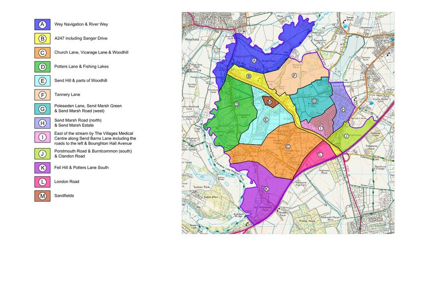
2
Send NDP Character Assessment 2019
Contents
                                                                            Page

1.   Introduction & Background                                              4
2.   Methodology of the Send NDP Character Assessment                       5-6
3.   Historic Development of Send Parish                                    7-8
4.   Assessment Criteria                                                    9
5.   Send Local Character Areas                                             10 - 75

Maps

Map 1 – Send NDP Local Character Areas                                      11
Map 2 – Send NDP Local Character Views                                      12
Map 3 - Gaps between Woking, Guildford, Send Marsh and Burnt Common         14
Map 4 - Send SSSIs, and SNCIs                                               15
Map 5 - Send Conservation Areas                                             17

                                                                                      3
                                       Send NDP Character Assessment 2019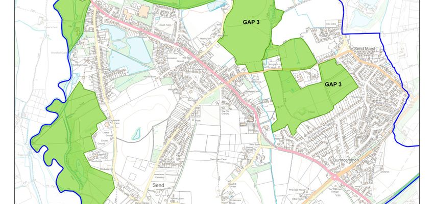
Introduction & Background

What is it?
“A character assessment is a document that describes the distinct appearance and feel of a settlement or an area. It communicates
the key physical features and characteristics that combine to give a particular settlement or an area its local distinctiveness and unique
identity.” (How to prepare a character assessment to support design policy within a Neighbourhood Plan, Planning Aid England)
The Character Assessment document will create an understanding of a development’s setting and the character of the local area. The
document which describes the existing character of the neighbourhood area will enable;
   • development to keep with the feel and appearance of the local area and
   • developers progress sensitively designed proposals

“Landscape reflects the relationship between people and place, and the part it plays in forming the setting to our everyday lives. It is a
product of the interaction of the natural and cultural components of our environment, and how they are understood and experienced
by people.” Christine Tudor – Natural England

Benefits
Poorly designed development proposals are often the result of a lack of understanding of, or in some cases a disregard for, the
character, feel and appearance of the local area. Such proposals can fail to conserve or enhance the unique qualities of the local
area for which they are proposed, and may harm and erode the existing character.

Conversely, good design, that is both visually attractive and functional, stems from having an understanding of a development’s setting
and the character of the local area. This understanding can help to ensure that new development proposals are of an appropriate
design; one that respects and compliments the existing local character.

By preparing a character assessment you have the opportunity to document and describe the existing character of your
neighbourhood area. The character assessment can then be used by developers and their architects to help them understand the
local character. This in turn will help them to progress sensitively designed proposals, in keeping with the feel and appearance of your
local area.

                                                                                                                                             4
                                                     Send NDP Character Assessment 2019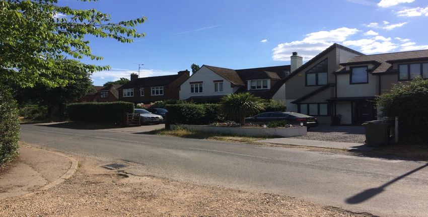
Methodology of the Send NDP Character Assessment                        during the desktop exercise using parish boundary maps of the
                                                                        built up area.
This assessment has been carried out using a combination of
approaches by the 2004 Natural England guidance “An
Approach to Landscape Character Assessment” and Planning
Aid England (Character assessment – Putting the pieces
together).

A parishwide neighbourhood plan survey was undertaken
between April and May 2018. The concept of a character
assessment was explained across two pages listing all possible
ten criteria of what constitutes or contributes to a character of
an area. Residents were asked to identify areas within the Parish
with prominent features of any or more of the criteria. The
criteria listed with descriptions were
    1. Layout
    2. Topography
    3. Land use
    4. Roads, Streets, routes
    5. Buildings and Details
    6. Streetscape
    7. Landmarks
    8. Green and Natural Features
    9. Spaces
    10. Views

Residents were asked to be involved in a character assessment
workshop to be held the following month which will enhance
and build on the outcome of the survey

Defining Purpose and Scope – A half day workshop was held on
Monday 18th June 2018 at the Lancaster Hall on Send Road. The
first part of the workshop was to define the purpose and scope
of the assessment. 13 common character areas were identified
                                                                                                                                        5
                                                    Send NDP Character Assessment 2019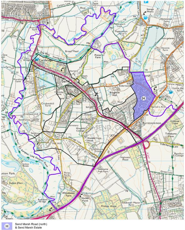
Field Survey – The group was split into 4 area group (depending
on attendees interest and where the live) to go out with their
notepads, templates and cameras to the identified common
character areas and record all observations including taking
pictures – During the field survey the identified key
characteristics and features of each character area were
recorded on a standardised template/form.

Upon return form the walkabout, each character area group
summarised its observations to the whole group. The next step
was for each group to compile their findings in more details
regarding desk research findings, maps and field record
sheets/templates to inform the various classifications and
descriptions compiled into the draft report.

Consultation – The draft report will be shared with the character
assessment workshop attendees, Send NDP Working Group,
Send Parish Council and Guildford Borough Council for their
comments. The draft will be amended using feedback received
before it goes out to consultation with residents as part of the
neighbourhood plan Regulation 14 consultation.

                                                                                         6
                                                    Send NDP Character Assessment 2019
Historic Development of Send Parish
Send is a village and civil parish in the Guildford borough and acquired its name during the Great English    An extract from Rocque’s map of 1762
Vowel Shift from the word sand, which was extracted at various periods until the 1990s for construction
and other purposes at pits in the outskirts of the Parish. Send is buffered by Metropolitan Green Belt from
other villages and towns except for the Grove Heath neighbourhood of Ripley. A rural band of the
village adjoins the River Wey including Cartbridge and Send Marsh – this land has been drained and the
river tamed by sluices, the Broadmead Cut and the Wey Navigation, adjoining. The vast majority of the
built-up areas are not within an area of flood risk. Between the Wey and its canal in the far north of the
Parish are the Papercourt and Broad Mead SSSIs.

In 1762 there was no village, just a few houses round the church and a few at Send Marsh plus scattered
farms. There may have been no village but locally-found flints show there was settlement from pre-
historic times.

SEND CHURCH AND SURROUNDINGS - The rising ground close to the river seems to have been an
attractive spot for settlement. The ancient mound down Church Lane has had a place of worship for
over a thousand years. The earliest part of the current church, the chancel, is thought to be ca1220 and
the nave and tower from the 15th century. The old houses that are still in existence include the old hall
house, a 16th century timber-framed yeoman farmer’s house that now stands on the Send Grove estate.           Map 2
The house pre-dates Send Grove and was possibly empty from about 1600 until Send Grove was built
around 1760.

SEND GROVE – Was built around 1760 as a home for Lt General William Evelyn, great grandson of the
diarist John Evelyn. The Lodge to Send Grove is a small one-bay hall house at the top of Church Lane.
Originally a farm cottage, perhaps once owned by a farmer called Potter - hence Potters Lands, then
Potters Lane. Later it became the lodge to Send Grove at the top of the drive.

CARTBRIDGE - On the map of 250 years ago, there was no settlement at Cartbridge. The road crosses
the Wey Navigation but the area is described as Send Heath and shows no housing. The area was used
as a summer camp for troops but development came later. The Navigation, built between 1651-53, was
a significant development for the growth of Send because of the boat traffic which followed on from its
construction. Slowly development grew up round the crossing point, partly as a result of the Inclosure Act
(1803) and Awards (1814-15). The map of 1897 shows houses running down to the towpath in what is now
Potters Lane.

SEND MARSH GREEN- On the 1762 map it is possible to see a little community at Send Marsh Green. The

                                                                                                                                                     7
                                                            Send NDP Character Assessment 2019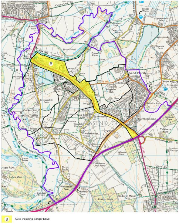
first mention of Send Marsh to have surfaced is in a deed of 1623 in which it refers to Maybanckes at        Map 3
Send Mershe. Send Marsh Green, which extends to Aldertons, would have been common land,
probably low-lying. Old Manor Cottage is the oldest domestic building in Send and it has been dated to
the first half of the 15th century. Other historic survivors are Send Marsh Cottage, formerly Pullens
Cottages, which dates from the18th Century and April Cottage, a typical smaller timber-framed house
from the second half of the16th century. Corner Cottage is of similar period. What is now Willow Pool
barn was the principal building in the former farmyard of Send Marsh Farm. Send Manor or The Manor
House was probably built around 1670. These are the principal period buildings that survive and of
course there are now many more modern additions, but Send Marsh has managed to remain a distinct
community.

FARMS, THE SCHOOL AND OTHER LOCAL EMPLOYERS - The area now called Send was basically
heathland, but surrounding areas were agricultural. As we have seen there was Send Court Farm down
by the church. In Potters Lane there was Cricketshill Farm and across the field was Hillside Farm, what is
now Aldertons at Send Marsh. Cottages, no doubt some of them tied cottages, would have been
needed for agricultural workers. The farms also used horses and these needed shoeing and machinery
needed mending and this led to another big step forward for Send – the smithy. On the 1897 map there
are still very few houses along what is now Send Road but the smithy is close to the crossroads. The other
                                                                                                             Send Church
innovation was the school on Send Hill. With more houses gradually springing up, there were more
children. The tannery was also at one time a local employer and was situated on the edge of the
developing village.

THE COMING OF THE RAILWAY - The big game-changer in the development of Send was the coming of
the railway to Woking which was built and opened in stages, and the first section was opened on 21st
May 1838. The road through Send became significantly more important as a route to the expanding
conurbation of Woking. By 1920 one side of Send Road had been developed and the church rooms and
the Institute (now the Lancaster Hall) built; slowly Send was being knitted together. By the 1930s the
recreation ground and the war memorial were in place. The growing population required more shops
and the parade of shops near the Rec was built. More housing was built along Send Hill taking
advantage of disused gravel extraction sites. Send Marsh Road between the crossroads and Send Marsh
Green also saw increased development. Send is a series of small settlements that gradually grew
together over hundreds of years. (History extracted from Send & Ripley History Society No. 257 |
November 2017)

                                                                                                                           8
                                                            Send NDP Character Assessment 2019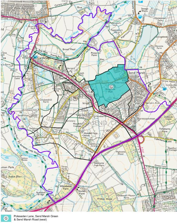
Assessment Criteria and what they cover

Layout                                   Topography                      Land use                            Roads, Streets, routes

Relationship between buildings,          Landscape setting / gradient    Residential, Retail, Leisure &      Vehicular routes, pedestrian
spaces and routes, and how these         of the local area (flat,        Recreation, Commercial,             pathways, cycle paths, shared
elements are arranged in relation to     sloping, valley, plateau,       Employment, Community, etc.         surfaces, rights of way, bridleways,
each other. Building plots (wide         hilltop, etc.)                                                      alleyways, etc.
narrow, long, short, etc.)

Buildings and Details                    Streetscape                     Landmarks                           Green and Natural Features

Building heights, arrangement            Lamp posts, benches and         Distinct and instantly              Trees, hedgerows, streams, rivers,
detached, semi-detached,                 seating, street surfacing       recognisable local features         ponds, lakes, woodland,
terraced or apartments), materials,      materials, signage, boundary    (including buildings, statues and   landscaped areas, etc.
construction era, roof types, distinct   treatments, etc.                monuments, and other locally
/ predominant architectural                                              significant features of the local
features, window types, condition,                                       area, both built and natural)
etc.

Spaces                                                                   Views

Parks, playing fields, allotments, cemeteries village-greens, car        Important views in and out of the character area (record location,
parks, market squares, etc.                                              direction and extent of view)

                                                                                                                                                    9
                                                         Send NDP Character Assessment 2019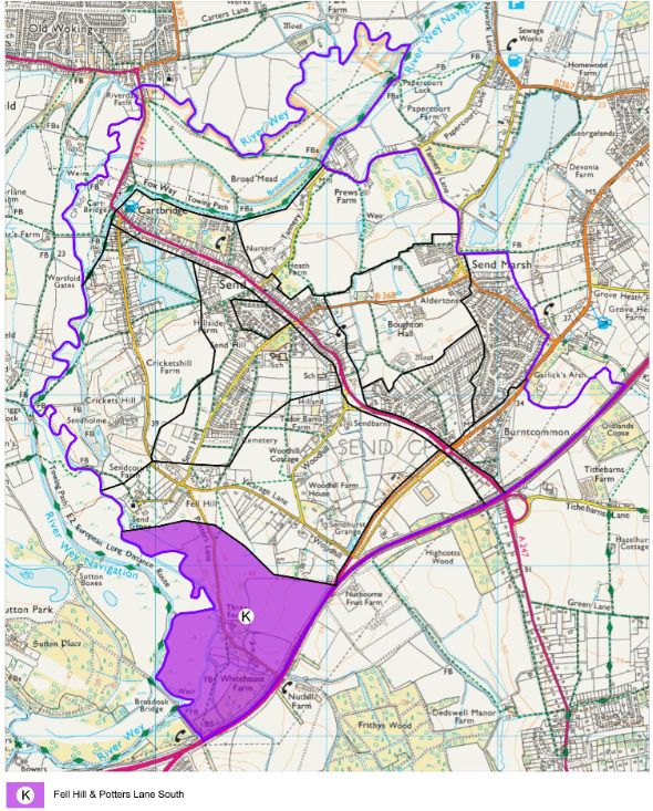
SEND LOCAL CHARACTER AREAS

Following the initial desk top and reviewing after the field survey study, 13 Landscape Character Areas (LCA) within the Parish boundary
have been identified. These identified areas have been mapped and each character area has been described in this section below
with their key characteristics and typical imagery

      A       WEY NAVIGATION & RIVER WEY

      B       A247

      C       CHURCH LANE, VICARAGE LANE & WOODHILL

      D       POTTERS LANE & FISHING LAKES

      E       SEND HILL

      F       TANNERY LANE

      G       POLESDEN LANE, SEND MARSH GREEN & SEND MARSH RD (West)

      H       SEND MARSH ROAD (north) & SEND MARSH ESTATE

      I       EAST OF THE STREAM BY THE VILLAGES MEDICAL CENTRE ALONG SEND BARNS LANE INCLUDING THE ROADS TO
              THE LEFT & BOUGHTON HALL AVE
      J       PORTSMOUTH ROAD, BURNTCOMMON (South) & CLANDON ROAD

      K       FELL HILL & POTTERS LANE SOUTH

      L       LONDON ROAD

      M       SANDFIELDS

                                                                                                                                     10
                                                Send NDP Character Assessment 2019
Map 1 - SEND LOCAL CHARACTER AREAS
11
Send NDP Character Assessment 201912 Send NDP Character Assessment 2019
Gaps between Woking, Guildford, Send Marsh and Burnt Common
Gap 1 – The    The gap between Woking and Send is also the gap between Woking Borough Council and Guildford Borough Council.
Gap between    This gap main characteristic is that it is the part of the Wey Valley Corridor and is made of the water meadows and is
Woking and     criss- crossed by many small streams running into the River Wey. The Wey Navigation is distinct from the River Wey in this
Send           area and the Navigation is generally higher than the river and also acts barrier when the river frequently floods. This
               area has many footpaths with walkers and bikers being frequent users of the tow path. The Navigation provides
               recreational activities. Narrow boats, kayaks and fishing all use the Wey Navigation. This gap between the settlements
               is a green environmental buffer zone which protects the rural nature of Send. This area provides a natural barrier
               between urban Woking and rural Send and it is one of the features which give Send its identity.

Gap 2 - The    The fields on either side of the A3 provide the main gap between Send and Guildford but this is outside of the Parish.
Gap between    The fields on either side of Potters Lane are a barrier to the town of Guildford and in particular the areas of Burpham
Send and       and Jacob’s Well and Slyfield extending north to Send. This area is important in preventing settlement coalescence
Guildford      and the associated loss of character that would result if the town of Guildford and the village of Send were joined.

Gap 3 - The  The Parish of Send comprises of the settlements of Send, Send Marsh and Burnt Common as acknowledged on the
Gap between Parish Council logo
Send, Send
Marsh and
Burnt Common

               Each settlement has its own characteristics and if these were joined the consequence would be that each settlement
               would lose its distinct character and would undermine the identity of Send Parish. It would bring about an associated
               loss of character to the village. The gap between these settlements is important in the green infrastructure of Send and
               its eco-system. It provides an important green corridor for wild life and links the higher ridge of the area around the
               Portsmouth Road with the water meadows of the River Wey.

                                                                                                                                            13
                                                      Send NDP Character Assessment 2019
Map 3 - Gaps between Woking, Guildford, Send Marsh and Burnt Common
14
Send NDP Character Assessment 2019Map 4 - Send SSSIs and SNCIs
15
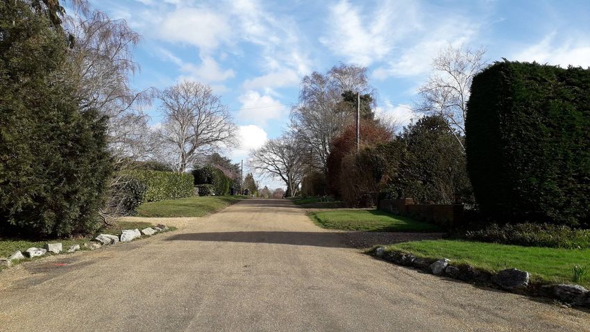
Send NDP Character Assessment 2019CHARACTER AREA A - WEY NAVIGATION & RIVER WEY
Summary Description
A very tranquil and attractive countryside area away from the business of the main road and traffic noise. The variety in the nature and all the
wildlife add to the enjoyment of the river as a lovely place to have on your doorstep for those who live in or nearby Send. Wherever you go along
The Wey Navigation the views are beautiful whether it is across open fields or picturesque scenes at Triggs Lock or Worsfold Gates. Over the canal
bridge on to the tow path is Send Business Centre in Tannery Lane with windows overlooking canal and fields beyond. Further along is a new marina
basin with a number of boats moored. New Inn pub and mixture of Semi-detached houses and bungalows. Residential properties with gardens back
onto the river at the end of Wharf Lane (bungalows), Sanger Drive (all detached). A large estate house (Ashburton House) with ornamental statues in
garden backing onto canal. A modern house with immaculate garden and high security backing onto tow path by canal. Along from Sanger Drive
small scout hut and boat house. Off Potters Lane is a small boat house for Sea Rangers and a large factory at Vision Engineering.
Key Characteristics
• Flat meandering river navigation, low lying in a corridor/valley.
• Edged by bulrushes, vegetation and trees.
• Many little lanes off main roads / bridleways/footpaths to the Wey navigation and
the River Wey
• Overlooking open fields across Broadmeads.
• Lots of trees shading the tow path.
• Small tributaries which run off the main river and the Wey navigation.
• Landmarks include footbridges (Send Business Centre) & Triggs Lock. By Cartbridge
is Send Evangelical Church and The New Inn pub.
• Views from the lock across field to the Saxon parish church of St Marys.
• Residential properties with gardens back onto the river including old buildings
Send Lodge and small cottages relating to the locks and Wey navigation.
• This character area contains part of the Wey & Godalming Navigations
Conservation Area, Broadmead Cut and Wey Navigation (wetland and willow
carr) which is a Site of Nature Conservation Importance (SNCI). As well as a Site of
Special Scientific Interest (SSCI). See map 1 – page 12.
• The National Trust Environmental Strategy recognises the historic significance of
the Navigations as one of the earliest schemes to enhance navigation of natural
rivers. It also identifies the River Wey and the Navigations as being of considerable
local importance and environmental sensitivity, providing opportunities for
informal recreation and learning.
16
Send NDP Character Assessment 2019Map 5 - Send Conservation Areas
17
Send NDP Character Assessment 2019Layout (Relationship Building plots backing on to navigation – Sanger Drive Detached houses with small gardens directly backing on the Wey
between buildings, Navigation. Some gardens have moorings. Wharf Lane end small semi-detached bungalows with long gardens to the Wey
spaces and routes) navigation. At Cartbridge Send Evangelical Church, a church on large plot with fence separating from tow path. Track
behind New Inn pub separates row of semi-detached houses and also small bungalows all with long back gardens. Further
up lock keepers cottages with fairly large gardens backing on to tow path (keep goats etc.). Two large estate houses with
large plots and gardens backing onto navigation (one of these - Ashburton House on central area large estate with
ornamental statutes/bridges etc. in garden across from tow path)
Topography (Flat, Flat meandering Wey navigation navigation, low lying in a corridor/valley – when Potters Lane and Send Hill go upwards the
sloping, valley, plateau, Wey navigation remains on the level and footpaths take you up to the roads. Otherwise the Wey navigation runs parallel to
hilltop, etc.) the roads or slightly in a dip
Land use (Residential, As you walk over the canal bridge on to the tow path at Send Business Centre in Tannery Lane you see the business centre
Retail, Leisure, on your left which used to be a Tannery alongside the waterway. It is divided into many small business units which have
Commercial, windows overlooking the canal and fields beyond (A number of local people are employed here). Walking further you see
Community, etc.) a new marina basin with a number of boats moored. There are residential properties alongside the navigation and then the
large factory at Vision Engineering screened in summer by vegetation) The factory employs a number of local people and
others come from surrounding area. There are small cottages relating to the locks and Wey navigation and then a lot of
open fields (used for farming/stables etc). Anglers are often to be seen along all stretches of the Wey navigation.
Roads, Streets, routes Tow path alongside length of navigation. Wherever you go along the main road and roads off the main road in Send there
(Roads, footpath, are little lanes off these roads or bridleways/footpaths to the Wey navigation e.g. Tannery Lane, Wharf Lane, Sanger Drive,
pavements, cycle Heath Drive, Potters Lane, Church Lane etc. Cyclists, walkers of all ages and especially dog walkers all use the tow path
paths, bridleways, etc.)
Buildings and Details Residential properties on the settlement side with gardens backing onto the Wey navigation at the end of Wharf Lane
(Building heights, type, (bungalows), Sanger Drive (all detached) some alongside the A247 by Cartbridge (old buildings Send Lodge and old lock
age, materials, keeper cottages by canal) Over footbridge to tow path on other side parallel to Potters Lane. The New Inn pub and mixture
arrangement, / of Semi-detached houses and bungalows with gardens backing onto a track running alongside Wey navigation. A large
predominant estate house (Ashburton House) with ornamental statues in garden also backing onto canal. One very modern house with
architectural features, immaculate garden and high security backing onto tow path by canal. Along from Sanger Drive small scout hut and boat
etc.) house, also small boat house for Sea Rangers off Potters Lane. By scout hut heavy screening of rhododendrons in summer
which hide the large global HQs of Vision Engineering and car park (more visible in winter)
Streetscape (Lamp The tow path is natural and cared for by National Trust. No bins or benches but noticeboards with maps of the navigation
posts, benches, show visitors where they are and distances to Woking and Guildford. No lighting apart from the factories and from
signage, boundaries, residential properties
etc.)
Landmarks (Distinct The Wey Navigation and The River Wey itself is a major feature of Send. Along the stretch you see various recognisable
and instantly landmarks such as footbridges (Send Business Centre), end of Wharf Lane, under road at Cartbridge, footbridge along from
18
Send NDP Character Assessment 2019recognisable local New Inn. Other features are Triggs Lock and view from the lock across field to the Saxon parish church of St Marys (one
features ranch of the Wey runs past the church). The New Inn pub is a feature and narrowboats moor by the small garden and
visitors have a drink and meal. Also by Cartbridge is Send Evangelical Church which can also be accessed from the
navigation.
Green and Natural Typical towpath edged by bulrushes by the navigation and vegetation and trees along the other side Overlooking open
Features (Trees, fields across Broadmeads. Lots of trees shading the tow path or screening the building especially in the summer months.
hedges, lakes, rivers, There are small tributaries which run off the River in places but are not accessible by boat. Fields to the right as you walk
woodland, etc. along the navigation to the right across Broadmeads are often flooded in winter (flood plains) and fields also further up.
Spaces (Parks, The Wey Navigation does not run alongside any of these amenities except at the Send Evangelical Church car park, and
allotments, cemeteries adjacent the work area for the National Trust. There is also small car parking area for the marina which can be seen from
village-greens, car the navigation.
parks, etc.
Views (Important views View of the Wey navigation valley from Send Evangelical Church and up further to Send Hill to overlook landscape of open
in and out of area) fields and Wey navigation navigations in distance. Wherever you go along the navigations the views are beautiful whether
it is across open fields or picturesque scenes at Triggs Lock or Worsfold Gates. There are also views in the other direction
towards Woking.
19
Send NDP Character Assessment 2019Local Character Area A direction of views
20
Send NDP Character Assessment 2019More Views of Local Character Area A
Looking over Wey Navigation from Highbridge over Looking over Wey Navigation towards the Tannery
Broadmeads towards Old Woking (View A2) from Highbridge (View A1)
Views from St Mary the Virgin churchyard looking towards Surrey Hills
21
Send NDP Character Assessment 2019Pictures from Local Character Area A
The New Inn Ashburton House
22
Send NDP Character Assessment 2019CHARACTER AREA B - A247 and inc SANGER DRIVE
Summary Description
The key impressions are of a very green environment and of a great variety of buildings ranging from terraces to semi-detached and detached houses.
There is a stretch of road lined by bungalows separated from the main road by an access road protected by a grass verge. Interspersed along the road are
businesses such as shops, a garage and car sales-room, community rooms. There are modern offices and a manufacturing business and a pub. The highest
point along this stretch of road is the Burnt common roundabout junction with the London and Portsmouth roads. The A247 then winds downhill to the flat
valley and the main settlement of Send. Send Road is flanked by a variety of housing. The oldest house is 400 years old. There are bungalows, terraces, semi-
detached and detached houses.
From Burnt Common to Send Hill traffic-lights the A247 runs through the village through to The New Inn before bearing sharpish right across the Broadmead
to Old Woking. The A247 is remarkably green in appearance. It is tree-lined with many broad grass verges, stretches of hedging and unmown swathes of
wild-flowers and daffodils. The A247 crosses over the Wey Navigation at Cartbridge and then is named as the Broadmead Road from the area it cuts
through. There are a number of small bridges in this area going over tributary streams of the Wey and then crossing the Wey at the boundary of Send Parish.
There is a Nature Area off Sanger Drive with two ponds. The Recreation ground is bordered by trees on three sides and a wooden fence with shrubs facing
the A247
Key Characteristics
• There are pavements on both sides for most of this stretch.
• Single carriageway with no cycle-paths. Road surface is mostly tarmac
• Street-lighting along the whole road, clear road signage, some benches.
• Landmarks include:- the Send Jubilee sign, blacksmith sculpture, memorial at the
recreation ground, The war memorial, The Grade 2 listed church rooms, The
Lancaster Hall and The New Inn next to The Wey Navigation.
• Housing is interspersed with a medical centre, a nursery/ primary school, modern
offices, and a very busy garage and car saleroom.
• Opposite garage is an extensive recreation ground with a range of facilities.
• A small shopping precinct with a post-office, café and a variety of shops separated
from the road by a verge and with car-parking space.
• There are fine views looking over the fields to the west.
• Green verges run alongside the main road through Send and lines the main street
(only on one side at the top of Send Barns Lane. These areas are part of the
ambiance and the character of Send Village with an open rural aspect which is
greatly valued by the community. This land on the margins of the road through the
village enhance the enjoyment of the journey through.
• There is a cycle path from Mays Corner to the Burnt Common Roundabout.
23
Send NDP Character Assessment 2019Layout (Relationship The three settlements within the Parish Send, Burntcommon and Send Marsh are separated by green fields. Woking and
between buildings, spaces Send are separated by the Broadmead an extensive area of wetland.
and routes)
Topography (Flat, The high point along this stretch of road is the Burntcommon roundabout junction with the London and Portsmouth
sloping, valley, plateau, roads. There are fine views looking over the fields to the west. The A247 then winds downhill to the flat valley and the
hilltop, etc.) main settlement of Send.
Land use (Residential, The Send Road is flanked by a variety of housing. The oldest house is 400 years old. There are bungalows, terraces, semi-
Retail, Leisure, Commercial, detached and detached houses. Housing is interspersed with a medical centre, a nursery/ primary school, modern
Community, etc.) offices, and a thriving garage and car saleroom.
Opposite the garage is an extensive recreation ground with facilities for young and old including space for a football
pitch and with tennis courts and equipment for toddlers and older children. There is a small parade of shops with a post-
office, café and a number of other shops separated from the road by a verge and with car-parking space. Further
along there is the village hall and Grade 2 listed church rooms and a popular pub the New Inn by the Navigation
Roads, Streets, routes From Burntcommon to Send Hill traffic-lights the A247 runs through the village. It then becomes a straight road to the
(Roads, footpath, New Inn before bearing sharpish right across the Broadmead to Old Woking. The Broadmeads only has pavements on
pavements, cycle paths, one side. The road is single carriageway both ways and at times is extremely congested. There are no cycle-paths.
bridleways, etc.)
Buildings and Details There is a great variety of housing along the road including modern villas, at least one 400 hundred year old house,
(Building heights, type, age, newer semi-detached and detached houses, bungalows, a terrace opposite the recreation ground. All are two-storeys
materials, arrangement, / or less apart from one visible attic conversion. The vast majority show brick construction with some being rendered. At
predominant architectural intervals there are buildings such as the medical centre, the school, converted flats, a car salesroom, shops and
features, etc.) manufacturing sites, community buildings such as the Church Rooms, the Lancaster Hall and The New Inn.
Streetscape (Lamp posts, There is street-lighting irregularly spaced and starts from Catbridge to the medical centre.
benches, signage, There are pavements on both sides of the road apart from the beginning and end of this stretch where there is only a
boundaries, etc.) single pavement. There is clear road signage. There are some benches. Road surface is mostly tarmac. There are newly
placed bollards by the school.
Landmarks (Distinct and The Send Jubilee sign at the traffic lights junction with Send Hill and Send Marsh Road. The blacksmith sculpture
instantly recognisable local indicating where the old smithy was situated. The memorial at the recreation ground, The war memorial, The Grade 2
features listed church rooms, The Lancaster Hall and the New Inn next to the Navigation a very pretty and picturesque spot.
Green and Natural The A247 is remarkably green in appearance. It is tree-lined with many broad grass verges, stretches of hedging and
Features (Trees, hedges, swathes of wild-flowers particularly daffodils. Features include the ‘triangle’ near the school a beautiful stretch of grass
lakes, rivers, woodland, etc. and trees. Opposite next to the medical centre is a small wild-life area of wetland. The road crosses streams eventually
joining the Navigation beyond Send Marsh. There is a local green space with two ponds in Sanger Drive.
The recreation ground is a large area of grass and trees.
24
Send NDP Character Assessment 2019Spaces (Parks, allotments, In the village of Send we are most fortunate to have lovely verges for people to enjoy in both Send Road and Send
cemeteries village-greens, Barns Lane. From the Church rooms to the shops in Send Road we have a wide grassed margin planted with ancient
car parks, etc.) Oak trees. They in turn are under planted with daffodils which we enjoy in the spring time. Around the shop area we
have shrubs and bulbs lining the parking areas. We have a telephone box exhibition in this area too.
Adjacent to the recreation ground which is again well planted, there is again a wide grassed area which holds mature
trees and spring bulbs.
Opposite the Villages Medical Centre in Send Barns Lane there is a large triangular area with lush planting of trees
including Oaks, Willow, Silver Birches and other mature English native trees. The whole area is ringed with spring bulbs.
We also have several benches here for people to take their ease or to picnic which is a frequent event. Following on
from here the final stretch up Send Barns Lane has a wide margin with mature hedges with shrubs such as hawthorn,
sloes, holly, hazel etc.
Views (Important views in The village lies mainly in the valley bottom. The impression though along much of its length is one of green verges,
and out of area) hedges and trees.
Spaces, views and verges along Send Road
25
Send NDP Character Assessment 2019Pictures from Character Area B
Send Primary
Villages Medical Centre
Sanger Drive
Sanger Drive Lancaster Hall
Heathfield Marina
Church Room
26
Send NDP Character Assessment 2019CHARACTER AREAS C, D & E
Summary Description
Area C- CHURCH LANE, VICARAGE LANE & WOODHILL
Key Characteristics Very attractive buildings, the beautiful and ancient church and graveyard the stud farm, the
• Beautiful landscape and rural. view of Potters Lane ascending the Hill and Sendholm – a distinct and attractive dwelling -
• In Church lane, the houses are all several hundred define the character of this part of Send and should be maintained for the future. Land-use is
years old. part residential, and incorporating a stud farm and stables. A short, narrow lane, could be
• Vicarage Lane is distinct with very green aspect. considered an extension of Send Hill. Vicarage Lane is very narrow in part and does not always
• Vicarage Lane - few buildings, all distinctly allow for cars to pass in parallel. The topography is generally flat, surrounded by fields and large
different, large plots plots. A beautiful lane to drive down, overhung with beautiful, mature and varied trees, limited
• The view from Church Lane is beautiful in all housing on one side and open fields on the other. Very few lamp posts and lighting -in keeping
directions
with rural surrounding. Therefore, relatively little light pollution which is very important with
• Church Lane- Few buildings on this Lane, unique in
regard to wildlife and the general character of the area. Both Church Lane and Vicarage Lane
design and appearance.
contain limited and individual plots and houses, and in many parts are surrounding by fields,
• Church c 1000 years old and old buildings down
footpaths and countryside. The first record of a church in Send appears in William the
Church Lane, with a grave yard.
Conqueror's record "The Domesday Book" compiled in 1085. There are views across fields from
Church Lane, Vicarage Lane and Woodhill
Church Lane
27
Send NDP Character Assessment 2019Views: The view from Church Lane is beautiful in all directions, There are views across fields from Church Lane, Vicarage Lane and Woodhill.
Path by cemetery along Footpath (FP 59) Woodhill Road
Views from Vicarage Lane looking towards Surrey Hills from footpath (FP 62)
Woodhill towards Send Barns Lane from FP 64
Views from Woodhill towards Send Hill from FP 65
28
Send NDP Character Assessment 2019Local Character Area C direction of views
29
Send NDP Character Assessment 2019Summary Description
AREA D - POTTERS LANE & FISHING LAKES
Key Characteristics Potters Lane is a beautiful rural, winding country lane with lots of greenery – fields, trees,
• A winding rural lane in most part hedgerows and some beautiful gardens. The road layout is irregular where there are dwellings.
• Surrounded by farmland and beautiful countryside Buildings vary enormously in appearance e.g. – Sendholm is a large and imposing building set
in extensive grounds, but other housing stock includes detached large homes and well-spaced
views with many trees and hedgerows.
bungalows. Nearer the village and by the New Inn there are some terraced and semi-
• Tree-lined in many areas
detached houses but these are in the minority. At the bottom of Potters Lane towards the New
• Landuse is part residential, part farming, mostly
Inn most of the houses don't have off-street parking.
rural.
• Buildings are varied, mostly traditional. The landscape varies, a flat part of the lane towards the New Inn end, but the road rises and
• Very few lamp posts and lighting twists to a hill and passes through farmland. From various parts of the Lane it is possible to join
• Landmark is the Sendholm. public footpaths and access the canal. Many footpaths onto fields and to canal. Stud farm.
• Views from Potters Lane until the houses start are Access to fishing lakes from Potters Lane. Building plots both within the boundaries of the fishing
across fields with views to the Surrey Hills. There are lake, and of the properties surrounding this, are wide, individual and varied. Mostly detached.
views across the fishing lakes from the properties in Rural, unspoilt, flat, many trees and beautiful lakes. No lamp posts and lighting -in keeping with
the vicinity and from the footpaths. rural surrounding with relatively little light pollution which is very important with regard to wildlife
and the general character of the area. The fenced pathways around the lakes are un-made,
rural and natural. There is a fences path running through the fishing lakes
30
Send NDP Character Assessment 2019Views; Surrounded by farmland and beautiful countryside views with many trees and hedgerows. Views from Potters Lane until the houses start are across
fields with views to the Surrey Hills. There are views across the fishing lakes from the properties in the vicinity and from the footpaths.
Church Lane looking towards Send Hill FP 61 Church Lane looking towards Potters Lane FP 61
Looking across water meadows towards Wey navigation from footpath (FP 61)
31
Send NDP Character Assessment 2019Local Character Area D direction of views
32
Send NDP Character Assessment 2019Summary Description
CHARACTER AREA E - SEND HILL
Key Characteristics Send Hill has a feeling of space and is very green as a result of many mature trees and
• An open aspect and rural feel bushes. Trees and hedges everywhere giving a rural feel. Plot sizes vary in size and set back
• Narrow roads with very few footpaths at the side from road with front gardens. Layout largely linear. Send Hill is elevated with open views
of the road across fields. Views of open land looking towards Potters Lane from Send Hill. Cemetery has
• Views of countryside from a number of places open views across fields towards Woking, views to the Surrey Hills. The properties are mainly
• Limited street lighting detached houses and there are many dormer bungalows. It appears that many were
• Roads verges are very green with many trees previously smaller properties which have been extended. All are well maintained. All have
and quite narrow driveways and good parking which means that there is very little street parking. Very few
• Most houses are built of brick with a tiled roof. have gates to the drive but all (or possibly virtually all) have at least one garage. Houses
• Individual houses with front and back gardens, are well spaced and of mixed ages. Majority are detached with most built within the last
off street parking and garages on the plot 80 years in medium and large plots. Very little street lighting, dog bin by Send cemetery.
• Views of open land looking towards Potters Lane Individual boundaries some with fences and others with hedges/ green planting. Asphalt
from Send Hill. Cemetery has open views across street surfacing. Orchard Way is a cull de sac off Send Hill. This is a 1970’s development of
fields towards Woking, views to the Surrey Hills. mostly four bedroomed houses. It leads to Winds Ridge a road of mainly 1950’s and 60’s
bungalows.
1950’s bungalow, Winds Ridge
Orchard Way
33
Send NDP Character Assessment 2019Views of open land looking towards Potters Lane from Send Hill. Cemetery has open views across fields towards Woking, views to the Surrey Hill. Views
of open land and views from Potters Lane and Send Hill between Potters Lane and the cemetery has open views across fields towards Woking
Bin at path by cemetery (FP 59) Looking towards Woking by cemetery /Send Hill by
cemetery (FP 59)
Looking towards Surrey Hills over the water meadows (FP 59)
Looking towards Potters Lane from FP 59
34
Send NDP Character Assessment 2019Local Character Area E direction of views
35
Send NDP Character Assessment 2019AREAS C, D, E
Layout (Relationship The plots of the houses vary in size but all are set back from the road and have front gardens. The majority are “open” to
between buildings, spaces the road. Within the built area of Send Hill and Potters Lane the houses are set back from the road giving an open feel to
and routes) the streets. The layout is largely linear – most houses have wide plots and large back gardens.
Topography (Flat, Send Hill (between Potters Lane and the cemetery) is elevated and has open views across fields towards Woking. The
sloping, valley, plateau, views from Potters Lane until the houses start are also across fields with views to the Surrey Hills and the road rises from the
hilltop, etc.) A3 until it reaches the houses. Vicarage Lane and Church Lane are flat with the exception of the end of Vicarage Lane
closest to Potters Lane which is a downward slope.
Land use (Residential, The properties are all residential. The fishing lakes are recreational and in private ownership (Woking Fishing Club) but
Retail, Leisure, there are views from the properties in the vicinity and from the footpaths.
Commercial, Community, St Mary’s Church is in use and has been so for c900 years.
etc.)
Roads, Streets, routes The roads verges are green and have many trees. All of the roads are quite narrow and Send Hill from the cemetery to
(Roads, footpath, Potters Lane is single track as is Church Lane. It is difficult for cars to pass in Vicarage Lane (between Woodhill and Potters
pavements, cycle paths, Lane). There are many footpaths which are accessed from these roads. All are well used and on the day of the
bridleways, etc.) assessment many people were seen out walking on them. There are no footpaths on most of the roads nor are there any
cycle paths. The only footpath is in Potters Lane (from c footpath 55). Street surfacing is asphalt.
Buildings and Details Houses are set back from the road, typically wide plots with large gardens towards the hill on the Lane. The properties are
(Building heights, type, mainly detached houses and there are many dormer bungalows. It appears that many were previously smaller properties
age, materials, which have been extended. Most houses are built of brick with a tiled roof. All are well maintained. All have driveways
arrangement, / and good parking which means that there is very little street parking. Very few have gates to the drive but all (or possibly
predominant architectural virtually all) have at least one garage. Houses are well spaced and in the main individual and of mixed ages. The vast
features, etc.) majority are detached and most have been built within the last 80 years in medium and large plots. The houses in Church
Lane are all several hundred years old.
Streetscape (Lamp There is very little street lighting. Boundaries are all individual – some have fences whilst others have hedges or other green
posts, benches, signage, planting. There is a bin for dog waste by Send cemetery.
boundaries, etc.)
Landmarks (Distinct and St Mary’s Church c 1000 years old and old buildings down Church Lane
instantly recognisable Cemetery with room for extension and space for parking outside of the gates
local features
Green and Natural Trees and hedges everywhere giving a rural feel. Some are privately plated others are natural.
The fishing lakes are fenced.
36
Send NDP Character Assessment 2019Features (Trees, hedges,
lakes, rivers, woodland,
etc.
Spaces (Parks, Cemetery in Send Hill with room for expansion
allotments, cemeteries
village-greens, car parks,
etc.)
37
Send NDP Character Assessment 2019AREA F - TANNERY LANE
Summary Description
Originally Tannery Lane would have been a route from farms & small-holdings to the main N/S Road that is now the A247. Beyond the built up area
on the edge of Send is farmland (a Marina under development, Send Business Centre, and the Nature Reserve which is part of the Papercourt
Complex of Meadows & SSSIs on the north west side of Tannery Lane beyond the ‘canal’. The Private Nature Reserve in the corner of Tannery Lane is
run by the Surrey Wildlife Trust as a water bird / amphibian habitat. The area is drained by streams leading into the River Wey.
Mixed land-use including residential giving way to Farmland (on the east side of Tannery Lane or on the right as you come from Send Rd),
commercial / community / housing / leisure / employment to the left backing on the Wey Navigation. Victorian Cottages on narrow plots on south
east, right nearest Send Road. A number of footpaths / rights of way through farmland on right to the south east linking to Send Marsh Road and
beyond, From the houses and buildings on the north west side of Tannery Lane, left of the road one can see North-West across the Broadmead and
Wey Valley to the remains of the historic Woking Palace and beyond to the tower blocks of Central Woking.
Key Characteristics
• A narrow country Lane
• Flat, fertile, plain of the River Wey.
• Mixed land-use (Residential, farmland, commercial, leisure and employment)
• Semi-detached Victorian cottages on small plots with detached converted farm
houses/cottages on larger plots.
• All residential buildings are two stories high and brick built under tiled roofs.
• The lane is tarmarced
• Landmarks include Send Business Centre, River Wey
• Navigation and the Papercourt Complex of Meadows and Sites of Special
Scientific Interest (SSSIs)
• Private Nature Reserve in the corner of Tannery Lane
• A Site of Nature Conservation Interest (SNCI) – this site is adjacent to Papercourt
Marsh (See map 1 – page 12)
38
Send NDP Character Assessment 2019Layout (Relationship The first few hundred yards of Tannery Lane nearest Send Road comprise Victorian Cottages on narrow plots on the right
between buildings, with much wider, deeper plots on the left which have mixed usage. Thus there is a Garage, Send (Working Men’s) Club
spaces and routes) and a disused Nursery on the left which now trades in sun-dried logs utilising the old greenhouses to dry the logs. The
nursery has a 1970s? Office Block on part of the site fronting the lane. Behind the Nursery fields stretch down to the
Navigation. The disused Nursery is earmarked as a development site for 60 houses in the Local Plan.
Beyond the Nursery/Office Block/Cottages there is open farmland on the left used for grazing/crops (most of which is land-
filled) and a couple of larger houses on the right on large, wide plots which were once farm houses or farm worker’s
cottages. Beyond the Farm House / Cottages on the left is an area of Land currently being developed as a Marina serving
the Wey navigation Wey Navigation following granting of Planning Permission ca. 3 years ago, and ‘Send Business Centre’
(SBC), now a multi-purpose light industrial / office services site which acts as a base for a large number of small businesses
operating across a number of different sectors with a large Car Park and a number of Storage Containers on the opposite
side of the road. In the distant past it was a Tannery which gave its name to the lane on which the Business Centre now
sits. Beyond SBC, Tannery Lane forms the boundary of the Parish, with a number of cottages / bungalows on the left and
open-farmland, the occasional cottage and the nature reserve occupying the Send side.
Topography (Flat, Flat, fertile, plain of the Wey navigation Wey.
sloping, valley, plateau,
hilltop, etc.)
Land use (Residential, Residential giving way to Farmland on the right. Mixed Commercial / Community / Housing / Leisure / Employment on the
Retail, Leisure, left which backs on the Wey Navigation. On the other side of the Wey Navigation is the Broadmead, large parts of which
Commercial, comprise the Papercourt Meadows Nature Reserve and part of the Papercourt SSSI. These together with the Papercourt
Community, etc.) Marshes Reserve form the ‘Papercourt Complex’ of Nature Reserves and SSSIs.
Roads, Streets, Tannery Lane is a narrow Country Lane with a footpath along part of the route. Originally it would have been a route from
routes (Roads, local Farms & Small Holdings in the fertile Wey navigation plain to the main N/S Road that is now the A247. (N.B. The
footpath, pavements, disused Nursery was one of several in the Parish of Send prior to the sand and gravel extraction activities of the mid-late
cycle paths, bridleways, 20th Century). There are a number of footpaths / rights of way through the farmland on the right which link through to Send
etc.) Marsh Road and beyond, which probably originated as routes to work
Buildings and Details The cottages are mostly of the semi-detached Victorian two-up two-down type on small plots whilst the Farm Houses /
(Building heights, type, converted Cottages are detached on larger plots and are believed to be Georgian in origin. All residential buildings are
age, materials, two stories high and are brick built under tiled roofs.
arrangement, / The Office Block & Send Business Centre are the equivalent of three to three and a half stories high. The Business Centre is
predominant a mixture of Building Styles having been redeveloped and extended several times since its original construction.
architectural features,
etc.)
Streetscape (Lamp Occasional low-level energy saving lampposts. The lane is tarmarced but poorly maintained with green verges and is
posts, benches, signage, prone to surface water ‘flooding’ following rainfall due to the local topography and poor drainage.
39
Send NDP Character Assessment 2019boundaries, etc.)
Landmarks (Distinct None other than the old Tannery (now Send Business Centre), the Wey navigation Wey & Navigation and the Papercourt
and instantly Complex of Meadows and SSSIs, though most of the latter is in the adjacent Parish.
recognisable local
features
Green and Natural Fencing / boundary walls in the residential areas with lane-side hedgerows and occasional mature trees beyond that. The
Features (Trees, area is drained by Ockham Mill Stream (see below) in the South and the Wey navigation Wey & Broadmead Cut in the
hedges, lakes, rivers, North. In addition to the Papercourt Complex there is a Private Nature Reserve in the corner of Tannery Lane run by the
woodland, etc. Surrey Wildlife Trust as a water bird / amphibian habitat.
Spaces (Parks, Apart from the Business Centre Car Park the main publicly accessible open space is the Papercourt Meadows Reserve (19
allotments, cemeteries Hectares) and that part of Papercourt SSSI that lies within Send Parish (the remaining part of Papercourt SSSI lies within
village-greens, car parks, Ripley Parish). There is also the smaller Papercourt Marshes Nature Reserve (10 Hectares) though this is run by the Surrey
etc.) Wildlife Trust and is inaccessible to the public except with special permission and currently appears overgrown with reads.
Views (Important views From the houses and buildings on the left of the road one can see North-West across the Broadmead and Wey Valley (all
in and out of area) part of Send Parish) to the remains of the historic Woking Palace and beyond to the tower blocks of Central Woking.
Along canal at Tannery Lane is the Highbridge with good views mostly across the broadmeads.
Views
Warf Lane – view going to Highbridge looking Warf Lane – towards Highbridge from Warf Lane – view going to High Bridge
towards marina FP 49 (View F1) FP 49 looking towards marina along FP 49 (F1)
40
Send NDP Character Assessment 2019Local Character Area F direction of views
41
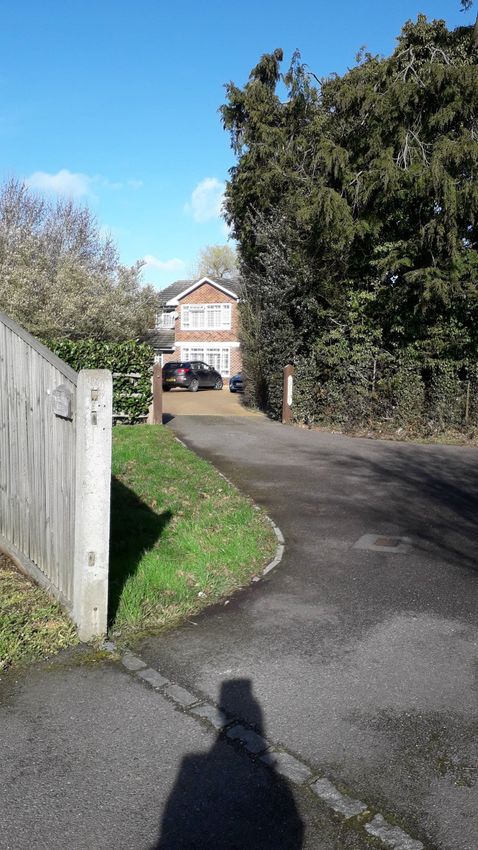
Send NDP Character Assessment 2019Some images from Character Area F
42
Send NDP Character Assessment 2019AREA G - POLESDEN LANE, SEND MARSH GREEN & SEND MARSH ROAD (west)
Summary Description
Polesden Lane and Send Marsh Road (westbound from Send Marsh Green) features most of the oldest surviving buildings in Send, many of which are
listed. The other dwellings in the area are mid 20thC with the exception of the 1990s Danesfield Estate which is largely hidden from the ‘main’ road
with the exception of the four houses fronting it. Polesden Lane has green verges and is prone to surface water ‘flooding’ following heavy rainfall due
to topography and poor drainage. Send Marsh Road has a kerb and pavement on one side and green verges on the other, and again is in need of
repair in parts. Both Polesden lane & B368 have a pavement on one side and verges / hedgerows on the other. All other roads are cul-de-sacs
giving access to the houses thereon.
Further along Polesden Lane comes Send Marsh Green, one of the two oldest surviving areas of Send to be developed with a number of listed
buildings on two sides of the triangular Green. The third side of the Green is taken up by mid 20thC bungalows/semi-detached houses. On Send
Marsh Road between the Green and Send Village is a row of Bungalows, then open fields/areas of woodland delimiting Send Marsh from Send
interspersed with large detached houses. There are a number of ponds due to the low-lying nature of land and a number of footpaths through the
farmland on both sides of Send Marsh Rd through to Tannery Lane to the North / Portsmouth Road to the South
Key Characteristics
• A flat, fertile river plain.
• Landmarks are The Green, Manor House, Aldertons, Goodgrove and the Old Hall
Residential Home
• Detached or semi-detached buildings on relatively large plots, brick built or timber-
framed with brick infill under tiled roofs
• Buildings date back to the 15th and 17th centuries.
• A light industrial estate on the Rio Estate,
• Fields used for grazing horses or left fallow
• Roads are mainly fronted by hedges or dwarf walls / fences topped with hedges.
• There are allotments leased by Send Parish Council situated off Polesden Lane and the
Green.
• Modern Danesfield Estate built in late 1990’s
• There is a medieval moated site and earlier earthwork south of Boughton Hall. This moat
survives well despite the former presence of a piggery on the moat island. It is of
somewhat unusual form and retains considerable potential for the recovery of evidence
of the nature and duration of use of the site both from the moat island and from the
moat itself.
43
Send NDP Character Assessment 2019Layout (Relationship The first developed area along Polesden Lane from its junction with Tannery Lane is the Rio Estate, a light industrial estate
between buildings, spaces on the right comprising five factory units backing onto Send Allotments and the Tannery Lane farmland. Next to this
and routes) Estate is a 40 unit 1990s housing estate developed on a site previously famous for breeding Great Danes. Further along
Polesden Lane comes Send Marsh Green, one of the two oldest surviving areas of Send to be developed with a number
of listed buildings on two sides of the triangular Green. The third side of the Green is taken up by mid 20thC
bungalows/semi-detached houses, the latter being mainly timber-framed perhaps to echo the age of the earlier
buildings. The plots around the Green are relatively large so there is a limited amount of 20thC
infilling/backfilling/redevelopment of outbuildings of the homes fronting the Green and accessed from it.
On Send Marsh Road between the Green and Send Village, there is a row of Bungalows, then open fields/areas of
woodland which delimit Send Marsh from Send interspersed with large detached houses, two of which are listed. There is
also the Old Hall Residential Home which has been re-developed as a Care Home with newer buildings behind the
original. The fields have more recently been used for grazing horses or left fallow rather than farmed with many of the
out-buildings of Alderton’s Farm being recently re-developed as housing. The area beyond Ockham Mill Stream
comprises largely smaller linked / semi-detached houses or similar, adjacent to the A247, Send Road and is more akin to
Send itself.
Topography (Flat, Flat, low-lying land, fertile Wey navigation plain.
sloping, valley, plateau,
hilltop, etc.)
Land use (Residential, With the exception of the Rio Industrial Estate, the Old Hall (private) Care Home, and the fields separating Send Marsh
Retail, Leisure, from Send Village the area is almost completely residential barring the Leisure & Recreation facilities provided by the
Commercial, Community, Green and local footpaths which are used extensively by local families and dog-owners for exercise along with the
etc.) occasional bird watcher.
Roads, Streets, routes Originally part of the route from Newark Priory to Send Church. That part of Polesden Lane located in Send was widened
(Roads, footpath, in the early 1980s to link gravel extraction (subsequently landfill) activities to the wider road network. It is now the route
pavements, cycle paths, from Pyrford, & Ripley Sewerage works to the A3 & A247. It joins Send Marsh Road at the Green. Both Polesden lane &
bridleways, etc.) B368 have a pavement on one side and verges / hedgerows on the other. All other roads are cul-de-sacs giving access
to the houses thereon. There are a number of footpaths through the farmland on both sides of Send Marsh Rd through to
Tannery Lane to the North / Ports-mouth Road to the South again reflecting previous generation’s shortest route to work!
Buildings and Details The buildings are detached or semi-detached on relatively large plots. With the exception of The Manor House (which
(Building heights, type, has three) they comprise two stories. There is however two mid 20thC bungalows on The Green and a row of half-a dozen
age, materials, where it joins Send Marsh Road. Four of the cottages and The ‘Manor’ House fronting Send Marsh Green, together with
arrangement, / Aldertons & Goodgrove situated further along Send Marsh Road towards Send Village were first built in the 15th - 17th
predominant architectural Centuries and have the privilege of being listed but have been extended / modernised over the years since. Also of
features, etc.) significance is the former Boughton Hall which is not listed and has been redeveloped as a Residential Home. The
remaining dwellings were mostly built in the mid 20thC with the exception of the 40 house Danesfield Estate built in the
44
Send NDP Character Assessment 2019You can also read