(SHLAA) Wolverhampton Strategic Housing Land Availability Assessment
←
→
Page content transcription
If your browser does not render page correctly, please read the page content below
Sensitivity: NOT PROTECTIVELY MARKED

                           Wolverhampton
                               Strategic
                             Housing Land
                        Availability Assessment
                               (SHLAA)

                                   Final Report

                            Update as of April 2020

                              Published: May 2021

                      City of Wolverhampton Council

          Site information can be viewed on an interactive map at:

           https://www.wolverhampton.gov.uk/planning/planning-policies/housing-
                                    site-information
Sensitivity: NOT PROTECTIVELY MARKED
CONTENTS
1.0 Introduction
2.0 The SHLAA Report Preparation Process
3.0 Wolverhampton Housing Requirements
4.0 SHLAA Purpose and Core Outputs
5.0 Methodology
Stage 1: Planning the SHLAA
Stage 2: Determining which sources of sites will be included in the
SHLAA
Stage 3: Desktop Review of Existing Information
Stage 4: Determining which sites and areas will be surveyed
Stage 5: Carrying out the survey
Stage 6: Estimating housing potential
Stage 7: Assessing when and whether sites are likely to be developed
Stage 8: Review of the Assessment
Stage 9: Identifying and assessing the housing potential of broad
locations (where necessary)
Stage 10: Determining the housing potential of windfalls
6.0 Results: Stages 5, 6 & 7
• Commitments Sites
• Public Sector Disposal Sites
• Other Potential Housing Sites
• Call for Sites Unsuitable for Housing
7.0 Results: Stages 8, 9 & 10
Stage 8
• Indicative Housing Trajectory
• Overall Risk Assessment
• Addressing the Shortfall
Stage 9
• Wolverhampton City Centre
• Analysis of Stage 9 Results
Stage 10
• Small Site Windfalls
8.0 Summary of Results
9.0 Potential for Density Uplift
2Sensitivity: NOT PROTECTIVELY MARKED
Figures
Figure 1 The SHLAA Process and Outputs
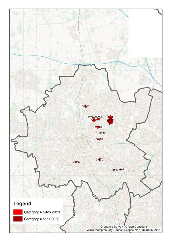
Figure 2 Map of Category 4) sites
Tables
Table 1 Wolverhampton SHLAA Timetable
Table 2 Sources of Sites with Potential for Housing
Table 3 Sites / Areas Not Suitable for Housing
Table 4 Sources of Information
Table 5 Policy HOU2 Accessibility Standards
Table 6 Delivery Profile of Commitments Sites
Table 7 Delivery Profile of Public Sector Disposal Sites
Table 8 Delivery Profile of Other Potential Housing Sites
Table 9 Summary of Net Housing Capacity on Identified Suitable Sites
Table 10 Housing Commitments and Allocations by Character Area
Table 11 Small Site Windfalls (Sensitivity: NOT PROTECTIVELY MARKED
1.0 Introduction
1.1 The Wolverhampton Strategic Housing Land Availability Assessment (SHLAA)
is a comprehensive study of sites within the City which have the potential to
accommodate new housing development. The Council is required to produce a
SHLAA by national planning policy set out in the National Planning Policy
Framework (NPPF). The SHLAA will form part of the evidence base to inform
the Wolverhampton Local Development Framework and will help to ensure the
timely delivery of new housing to meet Government targets.
1.2 The NPPF aims to:
• Deliver a wide choice of high quality homes;
• Significantly boost the supply of housing;
• Bring brownfield land and empty buildings into residential use, where
appropriate.
1.3 The NPPF and National Planning Practice Guidance provides current guidance
on undertaking a Housing Land Availability Assessment. This guidance
requires local authorities to:
- Identify specific, deliverable sites for the first five years of an up-to-
date plan that are ready for development and to keep this topped up
over time in response to market information;
- Identify specific, developable site for years 6-10, and ideally years 11-
15, of the plan;
- Where it is not possible to identify specific sites for years 11-15 of the
plan, indicate broad locations for future growth; and
- Only include an allowance for windfalls in the first 5 years of the plan if
they have compelling evidence that such sites have consistently
become available in the local area and will continue to provide a
reliable source of supply.
1.4 The guidance was updated during 2018 and Dec 2020 and this SHLAA report
takes account of the changes made in the following ways:
• The 5 year housing land supply calculation for Wolverhampton is now
measured against the standard method (2014-based household
projections1) and has a start date of the current year i.e. April 2020 for the
current SHLAA. This is because it is now more than 5 years since the
Black Country Core Strategy (BCCS) was adopted in 2011 and so the
BCCS is out-of-date. The cities and urban centres uplift has not been
applied for the 2020 update for the purposes of the 5 year housing land
supply, in accordance with the transition period arrangements set out in
para 037 of the NPPG;
• A 5% buffer has been applied to the 5 year housing land supply
calculation, in accordance with the Housing Delivery Test outputs for
Wolverhampton covering the period 2017-202;
1 In accordance with NPPG: Housing and Economic Needs Assessment (Dec 2020)
2 MHCLG Housing Delivery Test: 2020 Measurement (Jan 2021)
4Sensitivity: NOT PROTECTIVELY MARKED
• Sites with permission for, or potential for provision of, communal
accommodation are now included in the SHLAA and the housing supply.
The capacity of these sites is calculated using current national
adjustments (no. bedrooms / 2.5 for student accommodation, and no.
bedrooms / 1.8 for other communal accommodation). 3
• As the BCCS is out-of-date and the targets within it extend for 6 years
only, the SHLAA assesses how far housing supply will meet BCCS targets
2006-2026, but also how far supply will meet 10 and 15 year housing
need figures using the standard method. These additional calculations
have a base date of the current year;
• In assessing the delivery trajectory of sites, all small sites (< 10 homes)
with planning permission have been assumed for delivery within 5 years,
all other small sites without delivery information have been assumed for
delivery within 5-10 years and all major sites (10+ homes) have a tailored,
annualised trajectory based on robust delivery evidence4;
• The definition of windfalls has now changed to cover greenfield land as
well as previously developed land. Therefore, when determining the
housing potential of windfalls, including consideration of past trends, these
now include greenfield land, such as open space and residential gardens.
1.5 The SHLAA is a technical background document only. It is not a statement of
Council policy, does not allocate land, and is not a statutory planning document.
Once completed, it will form a key part of the evidence base for the BCCS
review (now called the Black Country Plan) and will be used to help inform
judgements on the allocation of land for housing within that Plan.
1.6 The SHLAA has considered the widest possible options for accommodating
residential development within Wolverhampton. However, it will not pre-empt or
prejudice any decision the Council may make in the future on any particular site
and does not alter any policies or land use designations as set out in the Local
Plan. Judgements concerning whether sites should be allocated in future LDDs
will be made through the statutory planning process, which will further test the
suitability of any sites identified in the SHLAA. Notwithstanding this, the fact
that a SHLAA has identified a site as having housing potential can be a material
consideration when planning applications are determined.
2.0 The SHLAA Report Preparation Process
2.1 The first draft methodology, “call for sites” and draft SHLAA report was
prepared in liaison with the Wolverhampton SHLAA Stakeholder Panel during
2009, as supporting evidence for the Black Country Core Strategy (BCCS)
Publication Report. Amendments were made to the draft SHLAA report in the
light of responses made and the final SHLAA Report was published in
February 2010 to support Submission of the BCCS to the Secretary of State.
2.2 Wolverhampton has since published an updated SHLAA report each year,
and a continuous, open “call for sites” is in place. Minor amendments have
been made to the SHLAA methodology over the years in response to
changes in national guidance, to ensure standardization with the Dudley,
3MHCLG Housing Delivery Test Measurement Rule Book, 24 July 2018
4In accordance with NPPF Annex 2: Glossary definition of Deliverable and 26 Oct 2018
MHCLG Consultation on changes to PPG including the Standard Method
5Sensitivity: NOT PROTECTIVELY MARKED
Sandwell and Walsall SHLAA’s and in the light of subsequent comments
made by Stakeholders.
2.3 During summer 2017 a specific “call for sites” exercise took place as part of
the BCCS review, which included an invitation to submit sites in the green
belt. This “call for sites” invitation was then extended until June 2019. A
subsequent “call for sites” invitation was issued during 2020. The additional
sites submitted through these exercises have been included for consideration
in this SHLAA report (excluding sites which were subsequently withdrawn).
2.4 This SHLAA report (February 2021) has a monitoring base date of April 2020
in terms of planning permissions and completions. Subject to more recent
evidence, the SHLAA reflects the allocations and policies set out in the
adopted Bilston Corridor, Stafford Road Corridor and Wolverhampton City
Centre Area Action Plans and the “made” Tettenhall and Heathfield Park
Neighbourhood Plans and therefore reflects a complete and up-to-date Local
Plan coverage of site allocations for the City, which sets an important context
and evidence base for the review of the Black Country Core Strategy.
2.5 Due to time and resource constraints, it has not been possible to provide
detailed constraint information for each individual site in the SHLAA report.
However, individual site information can be made available upon request for
particular sites.
3.0 Wolverhampton Housing Requirements
3.1 As set out above (para 1.4), the SHLAA must now assess housing land
supply against two different sets of targets. One set is taken from the Black
Country Core Strategy (BCCS) and covers the period 2006 to 2026. The
second set is taken from the standard method, as set out in the NPPF and
NPPG, and is an annual figure which extends from the current year (April
2020) up to 2039.
Black Country Core Strategy Targets
3.2 Current performance against BCCS targets for Wolverhampton is set out
below:
Past Net Black Country Core Strategy (Feb 2011)
Completions Net Housing Target
2006-16 4266 5662
2016-21 2912 (2016-20) 2580
2021-26 - 5169
Total 7178 13411
3.3 The remaining housing requirement up to 2026 is 6,233 homes (net). The
SHLAA must identify specific deliverable sites to meet housing requirements
up to 2025, and specific developable sites to meet housing requirements up
to 2026 (6 years). The supply must include sufficient deliverable capacity to
address the under-supply of housing since the BCCS start date of 2006.
3.4 The BCCS net housing target for Wolverhampton from 2006-25 is 12,377
homes. Given that there were 7,178 net completions 2006-20, there is a
6Sensitivity: NOT PROTECTIVELY MARKED
remaining requirement for 5,199 net homes up to 2025. For the remaining
BCCS period 2025-26 the net housing target for Wolverhampton is 1,034
homes.
Standard Method
3.6 The starting point for the current standard method is the 2014-based
household projections. For Wolverhampton, the average annual household
growth for the period 2020-30 is 694.35. The 2020 median workplace-based
affordability ratio6 to be applied to this figure is 5.65. The % uplift to be
applied to the 694.3 figure is therefore (5.65 – 4 / 4) x 0.25 = 0.103. 1.103 x
694.3 = 766.
3.7 Therefore, the local housing need figure for the five year period 2020-25 is
3,830 net homes. Including a 5% buffer, as required by the Housing Delivery
Test, the five year supply of deliverable sites required to meet local
housing need would therefore be 4,022 net homes.
3.8 In terms of assessing longer term housing land need in the context of the
Black Country Plan review, it is appropriate to apply the cities and urban
centres 35% uplift to the annual need figure set out in para 3.6, as required by
NPPG para 004. This produces an annual need for 1,034 homes. Therefore
19,646 net homes would be required to meet local housing need for the
current Black Country Plan review period (2020-39).
4.0 SHLAA Purpose and Core Outputs
4.1 The main purpose of the SHLAA is to:
- Identify sites with potential for housing;
- Assess their housing potential; and
- Assess when they are likely to be developed.
4.2 The SHLAA will aim to identify as many sites with housing potential as
possible, taking into account national and BCCS policy constraints. Sufficient
sites will need to be identified to exceed the housing requirement for each 5
year period to allow for non-implementation.
4.3 The SHLAA will provide comprehensive baseline information, which will be
updated every year through the Wolverhampton Annual Monitoring Report
process. A comprehensive full re-survey will not be undertaken unless a
significant change takes place e.g. if a five year supply of specific deliverable
sites cannot be identified.
4.4 As a minimum, the SHLAA should provide certain core outputs and follow
minimum process requirements to ensure that it is robust and credible in
order to meet the tests of soundness set out in the NPPF. The SHLAA will
therefore provide:
5 www.gov.uk/government/statistical-data-sets/live-tables-on-household-projections#based-
live-tables
6
www.ons.gov.uk/peoplepopulationandcommunity/housing/datasets/ratioofhousepricetoworkpl
acebasedearningslowerquartileandmedian
7Sensitivity: NOT PROTECTIVELY MARKED
- A list of sites, cross-referenced to maps showing locations and
boundaries of specific sites (and showing broad locations, where
necessary);
- The potential quantity of housing that could be delivered on each
identified site or within each identified broad location (where
necessary) or on windfall sites (where justified);
- An assessment of the deliverability / developability of each identified
site to determine when an identified site is realistically expected to be
developed. This will include an assessment of any constraints on
delivery, how these constraints could be overcome and when.
4.5 Deliverable sites are defined as those which are suitable for housing and
there is a reasonable prospect that they will be available for delivery within
the next 5 years (by 2025). Developable sites are defined as those which are
suitable for housing and there is a reasonable prospect that they will be
available for delivery within the next 5-10 years (2025-30).
4.6 When judging whether there is a reasonable prospect of delivery within a
certain time period, both the constraints on the site (availability) and the
economic viability of the site (achievability) must be considered.
5.0 Methodology
5.1 The following figure is taken from the Practice Guidance and shows the 10
key stages of a SHLAA. The Wolverhampton SHLAA follows these key
stages, as set out below.
Figure 1 - The SHLAA Process and Outputs
8Sensitivity: NOT PROTECTIVELY MARKED
Stage 1: Planning the SHLAA
5.2 Practice Guidance encourages local planning authorities (LPA) to work
together at sub-regional / housing market area level and undertake joint
SHLAA’s wherever feasible7. However due to the differing stages of
surrounding authorities Local Plans, it is not possible to carry out a SHLAA
with surrounding LPA’s in the housing market area. The Black Country LPA’s
have differing resources to commit to the SHLAA process, and so a sub-
regional SHLAA has not been possible. However, a common methodology
and key assumptions have been applied, as far as possible given local
evidence.
Partnership working and consultation
5.3 When the first SHLAA was produced, a Wolverhampton SHLAA Stakeholder
Panel was formed, including representatives from a range of house-builders,
developers, land-owners, agents and delivery agencies. The Panel made
valuable contributions and input into production of the methodology and the
site assessment process and approved the final SHLAA 2010 reportAn
attempt was made to invite a wide range of house-builders, developers, land-
owners and property agents active in the Wolverhampton area, and
representatives from delivery agencies and housing associations. The
Council also consulted with external stakeholders throughout the SHLAA
process to gain their input and to help with issues such as environmental
considerations, infrastructure availability and capacity when appropriate.
5.4 During autumn 2020 a Black Country SHLAA stakeholder workshop was held,
with around 50 attendees from the development industry. Attendees were
invited to join a Black Country SHLAA Stakeholder Panel. A list of current
Panel members and terms of reference for the Panel are provided in
Appendix 1.
5.5 A meeting of the Panel took place on 24 February 2021, to discuss and
provide comments on the draft 2020 SHLAA reports / tables of sites and feed
into the final published reports. It is intended to involve the Panel on any
updates to the SHLAAs on an annual basis.
Resources
5.6 The Planning section of City of Wolverhampton Council have led and
undertaken the majority of work for the SHLAA. The section has on-going
experience of housing monitoring and benefits from a high degree of local
knowledge and in house expertise and access to GIS software and datasets.
Local property agents Bruton Knowles were commissioned to carry out a
comprehensive survey of vacant and derelict land and buildings in the City, to
update the existing National Land Use Database (NLUD), in 2009. This
survey provided key baseline information for the first SHLAA. A Level 2
Strategic Flood Risk Assessment of key sites has also been completed
through the AAP preparation process. Viability issues have been addressed
through work carried out by Mott Macdonald and GVA Grimley to support the
7Strategic Housing Land Availability Assessment Practice Guidance (DCLG 2007),
Paragraph 11
9Sensitivity: NOT PROTECTIVELY MARKED
BCCS, as set out in the BCCS Viability Study. Officers have worked closely
with colleagues from other departments.
5.7 The SHLAA preparation timetable to date is set out in Table 1 below.
Publication of the 2020 SHLAA Update was delayed until February 2021 for
two reasons: anticipated publication of the new national housing method
(which took place in Dec 2020); and completion of the land-owner
consultation evidence to inform removal of sites from the SHLAA (see para’s
6.3-6.6 below).
Table 1: Wolverhampton SHLAA Timetable
Output Dates
Initial SHLAA Panel Meeting / Consultation on May 2009
Proposed Methodology
Level 2 Strategic Flood Risk Assessment Feb – June 2009
Collate housing monitoring information for 2008-9 April – August 2009
Survey of vacant and derelict land and buildings April – August 2009
“Call for sites” May – June 2009
Compilation of information on surplus Council October 2009
sites
Assessment of sites within Broad Locations May – October 2009
BCCS Viability Study May – October 2009
Preparation of SHLAA Report October – November 2009
SHLAA Panel Meeting / Consultation on Amended November 2009
Methodology & Sample Sites
Draft Report published for consultation 30th November 2009
SHLAA Panel Meeting / Consultation on Proposed January / February 2010
Changes to Draft SHLAA
Final Report published February 2010
SHLAA Update Call for Sites November 2010
SHLAA Update December 2010 Report published January 2011
SHLAA Update May 2012 Report published May 2012
SHLAA Update December 2012 Report published January 2013
SHLAA Update November 2013 Report published November 2013
SHLAA Update January 2015 Report published January 2015
SHLAA Update September 2015 Report published September 2015
SHLAA Update May 2017 Report published May 2017
SHLAA Update Jan 2018 Report published January 2018
SHLAA Update Jan 2019 Report published January 2019
SHLAA Update Dec 2019 Report published December 2019
SHLAA Update Feb 2021 Report published February 2021
Stage 2: Determining which sources of sites will be included in the
SHLAA
5.8 There are a number of sources of sites with potential for housing (table 2),
both within and outside the planning process. There are three sources of
sites not currently in the planning process which are not applicable in
Wolverhampton – sites in rural settlements / rural exception sites; urban
extensions; and new free-standing settlements.
5.9 Housing renewal – the demolition and rebuild of public housing estates, both
small and large-scale – has been in the past a major feature of housing land
10Sensitivity: NOT PROTECTIVELY MARKED
supply in Wolverhampton, as in the rest of the Black Country. However, there
are currently no housing renewal demolition and rebuild schemes planned in
Wolverhampton. Therefore, this element was removed from the SHLAA in
January 2019, subject to review in future years. However, the Black Country
authorities agreed in 2020 to include a small-scale windfall demolition
estimate for the Plan period and this is taken into account in the small site
windfall allowance.
Table 2: Sources of Sites with Potential for Housing
Sites in the planning process:
• Land allocated (or with permission) for employment or other land uses,
which are no longer required for those uses
• Existing housing allocations and planning briefs
• Unimplemented/outstanding planning permissions for housing
• Planning permissions that are under construction
Sites not currently in the planning process:
• Vacant and derelict land and buildings
• Surplus public sector land
• Land in non-residential use which may be suitable for re-development for
housing, such as commercial buildings or car parks, including as part of
mixed-use development
• Additional housing opportunities in established residential areas, such as
under-used garage blocks
• Large scale redevelopment and re-design of existing residential areas
• Sites in rural settlements and rural exception sites
• Urban extensions
• New free-standing settlements
5.10 Where particular types of land or areas are excluded from the SHLAA the
reasons for doing so need to be justified and agreed by the members of the
SHLAA Panel. It was decided that, if sites are identified that fall within the
designations or parameters set out in Table 3, they should be assessed not
suitable for housing, in line with national, regional and local policy, as part of
the site “sieving” process.
Table 3: Sites / Areas Not Suitable for Housing
Ancient Woodland
Scheduled Ancient Monuments
Local Nature Reserves
Sites of Importance for Nature Conservation (SINC’s)
Historic Parks and Gardens
Areas identified in Black Country Strategic Flood Risk Assessment as Flood Zone 3b
Areas of open space identified in the most recent Wolverhampton Open Space Audit
and Needs Assessment, except where it can be demonstrated that these are surplus
to recommended standards and sufficient compensatory provision can be secured in
the local area.
11Sensitivity: NOT PROTECTIVELY MARKED
5.11 The Black Country Core Strategy (2011) excludes Green Belt land from
consideration for strategic housing development within the Black Country.
Wolverhampton has a limited amount of Green Belt land and much of this is
in active use for education, nature conservation, sport and other purposes.
However, some small housing sites have come forward in the Green Belt in
recent years. Therefore, Green Belt sites identified through the SHLAA
process will be subject to assessment. In the case of Green Belt sites where
it is considered that housing would constitute inappropriate development (as
set out in the NPPF), a preliminary assessment of characteristics and
capacity will be carried out. However, these sites will not be included in
assessments of capacity as they are not currently suitable for housing
development.
5.12 All sites which have been considered through the SHLAA process, but
discounted because they are not suitable for housing, for one or more of the
reasons set out above, are listed in Table 3 of Appendix 3.
Stage 3: Desktop Review of Existing Information
5.13 A systematic desktop search to identify potential housing sites and to review
progress on known sites was undertaken in 2009, and has been revisited for
each update, as set out in Table 4.
Table 4: Sources of Information
Housing Source Information Source
Site allocations not yet the • Sites allocated in the Adopted UDP 2006
subject of planning
permission • Sites allocated through development briefs and
subject to detailed design studies
• Sites allocated in the Bilston Corridor AAP,
Stafford Road Corridor AAP, Wolverhampton City
Centre AAP, Tettenhall Neighbourhood Plan and
Heathfield Park Neighbourhood Plan
Urban Capacity Study • Review all sites included in the Wolverhampton
Urban Capacity Study carried out to support the
UDP
Planning permissions / sites • Wolverhampton Planning Application system
under construction
• Wolverhampton Building Control system
Planning application • Wolverhampton Planning Application system
refusals
Sites subject to pre- • Wolverhampton Planning Team
application discussions
Sites suggested during • Review all sites submitted and contact parties
various planning document proposing sites.
consultations
“Call for sites” • Review sites submitted following call for sites
National Land Use • Review all sites included in the NLUD database
Database (derelict or vacant
land and buildings)
Vacant industrial and • Make use of NLUD database and assessments of
commercial property (e.g. employment land locations
vacant property registers;
12Sensitivity: NOT PROTECTIVELY MARKED
commercial property
databases)
Surplus Open Space • Wolverhampton Open Space Audit and Needs
Assessment (2008 and subsequent updates)
Broad locations identified in • Assess potential of sites within Publication
the Black Country Core Wolverhampton City Centre Area Action Plan
Strategy
• Assess areas of employment land identified for
potential release through BCCS, within
Regeneration Corridors and free-standing
employment sites (outside the AAPs)
Surplus public sector land • Review all sites which are surplus and where a
decision has been taken to dispose
Ordnance Survey maps and • Current and historic maps; three-dimensional
Aerial photography aerial photography
5.14 In May 2009, October 2010 and October 2011, a “Call for Sites” was issued,
requesting the formal submission of information regarding potential housing
sites using a simple proforma. The Call for Sites was posted on the Council
website and sent direct to a wide range of stakeholders, including all parties
who have previously submitted sites, landowners, agents and developers.
The Call for Sites form is attached as Appendix 3. During 2012 - 2020 there
has been an open “call for sites”. Additional “call for sites” were issued for the
BCP Review in summer 2017 and in summer 2020.
Stage 4: Determining which sites and areas will be surveyed
5.15 A number of factors were taken into account in determining how comprehensive
(in terms of geographical coverage) and intensive (in terms of minimum size of
site to be surveyed) the survey element of the SHLAA needed to be. These
include:
• The nature of the housing challenge - The assessment will be more
comprehensive and intensive where existing or emerging housing
provision targets in the study area are high and/or where housing
market conditions signal worsening affordability, reflecting the need to
identify more sites for housing;
• The nature of the area – in areas dominated by smaller rural
settlements, it may be necessary to identify all the sites with potential
for housing, whereas this may not be necessary or feasible in more
urbanized areas;
• The nature of land supply – where a large proportion of housing is
expected to be delivered on small sites this may mean that the survey
needs to identify smaller sites than would be necessary in an area
where larger sites are likely to make up the bulk of supply; and
• The resources available to the partnership – which can be brought
together for best effect and should reflect the scale of the task.
13Sensitivity: NOT PROTECTIVELY MARKED
Geographical Coverage
5.16 Wolverhampton is an intensively urbanised area and there is a large stock of
sites with current planning permission in the City. In recent years the majority
of new housing has been delivered on medium to large sized former
employment sites, which are concentrated in the south east of the City, and
on small, previously-developed sites across the whole of the City. Housing
completion levels since 2001 are provided in Table 2 and Graph 1 of
Appendix 6. Completions dipped during the recession but have picked up
again since. Stalled housing sites are now under construction and there is
growing developer interest in potential new housing sites, including flatted
developments and student accommodation.
5.17 Given the demanding nature of Wolverhampton’s housing requirements, and
the historic steady supply of windfall housing sites in a range of locations, it is
important that the SHLAA should fully address potential housing capacity by
identifying specific sites across the whole City. Such sites will include public
sector disposal sites, housing renewal sites, vacant and derelict land,
residential intensification sites, small non-conforming employment sites,
conversions and surplus open space, where housing use would be
compatible with adopted UDP, BCCS, AAP and NP policy requirements (see
Stage 2).
Specific Locations within Settlements
5.18 In the adopted BCCS, employment land locations are identified in
Regeneration Corridors within which around 100 ha’s of employment land
was identified as having potential for release for housing. Those locations
which fall within Regeneration Corridors 2, 3 and 4 are shown in Appendix 2
of the BCCS. There are also a number of Free-Standing Employment Sites in
Wolverhampton which are also employment land locations, and the BCCS
identifies 10 ha of these sites as a source of housing capacity. These sites
are not shown on any diagrams in the BCCS. Altogether, the BCCS allocates
former employment land within Wolverhampton sufficient to accommodate
around 3,800 homes. However, only 85% of homes are needed from this
source to meet housing requirements. This provides a 15% surplus capacity
to allow for options to be developed through Area Action Plans and
Neighbourhood Plans, and for the possibility of non-implementation.
5.19 The BCCS also allocates a specific housing capacity of 1100 homes to
Wolverhampton City Centre, largely as part of mixed use developments. This
is in accordance with the aspirations of the Council for the regeneration of the
City Centre and the significant number of housing completions and
commitments entering the housing supply in the City Centre in recent years.
5.20 The SHLAA will address these two sources of supply (employment land
locations and Wolverhampton City Centre) through the identification of
individual sites, where possible. Where sufficient individual sites cannot be
identified to meet housing targets, broad locations will be identified through
Stage 9 (see below).
Minimum size of site to be surveyed
5.21 Given the need to identify as many specific sites as possible through the
SHLAA, a site size threshold has not been set. The NLUD survey picks up
14Sensitivity: NOT PROTECTIVELY MARKED
sites down to a capacity of one home. However, given the large number of
identifiable sites within an urban area such as Wolverhampton, the resources
and time available to complete the SHLAA preclude the collection of detailed
information for smaller sites. Therefore, the information required to
demonstrate deliverability of small sites will be minimal. Small sites are
defined as those which could accommodate less than 10 homes. However,
where detailed information regarding smaller sites is available, this will be
made use of.
Stage 5: Carrying out the survey
5.22 Most of the originally identified sites formed part of the NLUD database and
were subject to a site survey during summer 2009. Other sites were
surveyed where detailed information was not already available from other
sources, for example through a planning application. The availability of up-to-
date 3D aerial photography for the City has greatly assisted in collating
information about the physical condition and location of sites.
Stage 6: Estimating housing potential
Net Developable Area
5.23 To estimate the housing potential of each site, an assessment of its net
developable area (as defined in the NPPF) needs to be made. There are a
number of factors that may influence the developable area of a site, including
topography, plot shape, the presence of trees, mineshafts, drainage and the
need for buffer zones. On sites capable of accommodating 40 homes or
more (as set out in Appendix 2 of the UDP), an allowance also needs to be
made for on-site open space and any other uses needed to serve the
development e.g. community uses and shops.
5.24 Where sites have already been subject to a detailed appraisal e.g. through a
planning application or development brief, the net developable area will
already have been established. In other cases, for larger sites, a site by site
assessment will be made of the approximate need for on-site open space
(with reference to the Wolverhampton Open Space Audit and Needs
Assessment) and community / commercial uses. On smaller sites the gross
area has been taken as the net developable area, except where there is a
need to exclude parts of the site subject to identified constraints.
5.25 When assessing the housing capacity of sites within broad locations, general
assumptions regarding net developable area will be applied based upon
those set out in the BCCS, including Appendix 2. On employment land, an
average net developable area of 85% will be applied to allow for open space
and non-residential uses required to serve medium to large-scale housing
developments. On non-mixed use housing sites within the City Centre, a
100% net development area will generally be applied. It is difficult to identify
an appropriate net developable area on mixed use sites in the City Centre,
where there may be a mix of uses in the same building, on different floors. In
such cases a net developable area of 100% will be applied and density
assumptions reduced to take into account the specific mix of uses.
15Sensitivity: NOT PROTECTIVELY MARKED
Density
5.26 BCCS Policy HOU2 requires that: “Each authority should aim to provide
an overall mix of house types over the plan period suitable to
accommodate the following proportions of household types:
1 person households – 20%
2 person households – 40%
3+ person households – 40%”
This is to reflect projections that around 60% of new household demand over
the Plan period will be from 1 or 2 person households. A significant
proportion of this demand will be from older person households, likely to be
seeking to downsize from a larger property. Therefore, providing for the
needs of these smaller households will free up under-occupied
accommodation in the City for the use of larger households.
5.27 Appropriate density ranges for areas with different levels of sustainable
transport access to residential services are set out in the BCCS and
referenced in Policy HOU2 (see Table 5). The BCCS Infrastructure Study
indicates areas which currently have the specified levels of sustainable
transport access to different residential services. Across most of
Wolverhampton, and particularly within the Growth Network, there are high
levels of sustainable transport access to residential services or access could
be improved, and therefore this will not unduly constrain density. In general
terms, therefore, market conditions will be more significant in determining the
density of development delivered on each site.
5.28 For sites with a recent planning permission or other allocation, the established
and most recent capacity will be used. For larger sites, this will be supported
by evidence from land-owners and developers. For sites outside employment
land and the City Centre, and which are not currently within the planning
process, density assumptions will be applied in accordance with HOU2,
taking into account any constraints. For sites where a variety of designs
would be appropriate, the housing capacity of some sites will be expressed as
a range. However, the lower figure in the range will be used when calculating
total capacity.
5.29 On larger redevelopment areas, such as on employment land, where no other
information is available, a blanket density of 35 homes per hectare gross will
be appropriate. Assuming 85% net developable area, 35 dph gross would
generate an average net density of 41 homes per hectare. This level of
density falls within the “moderate” range in HOU2 and would not generally
require the provision of more than 15% flats. This approach does not reflect a
lack of sustainable transport access to residential services, rather a cautious
approach regarding market demand for higher density development.
Densities of over 60 dph will be applied within the City Centre and Bilston and
Wednesfield Town Centres in accordance with HOU2, as these areas would
generally not be suitable for lower density development.
Table 5: Policy HOU2 Accessibility Standards
Density / House Type Mix
Density (dwellings per hectare net) Very High: High: Moderate:
60 + 45 – 60 35 – 45
Only appropriate
within a
16Sensitivity: NOT PROTECTIVELY MARKED
Strategic Centre
or Town Centre
Indicative proportion of flats 50%+ 25-50% 0 – 25%
Indicative amount of housing suited Low Medium high
to families
Accessibility (by either walking or public transport, unless stated)
Employment - Strategic Centre or 20 min 20 mins 30 mins
other employment area
Health – Doctor’s surgery or Walk-in 10 mins 10 mins 15 mins
Centre
Fresh Food - Centre or foodstore Na 10 mins 15 mins
Education - Primary School (walking Na 15 mins 10 mins
distance only)
Stage 7: Assessing when and whether sites are likely to be developed
5.30 The NPPF requires all Local Planning Authorities to identify sufficient and
specific ‘deliverable’ sites to meet housing requirements for the first 5 years of
the Plan, and sufficient ‘developable’ sites for the next 5-10 years. Guidance
also requires the identification of sites considered ‘not currently developable’
for housing, where a constraint to development is severe and it is not known
how or when it may be overcome.
5.31 To be considered deliverable, a site should be available now, offer a suitable
location for housing development and be viable to develop, offering a
reasonable prospect that housing will be delivered on the site by the end of
the five year period. To be considered developable, a site should be in a
suitable location for housing development, and there should be a reasonable
prospect that it will be available for and could be developed at a specific point
in time.
5.32 Guidance states that an assessment of the suitability, availability and viability
of a site will provide the information on which judgements can be made in the
plan-making context as to whether a site can be considered deliverable,
developable or not currently developable for housing development. This
stage of the SHLAA will therefore individually assess identified sites against
these criteria.
5.33 The SHLAA will divide sites (and, in some cases, phases of sites) into seven
specific categories:
1 Sites not suitable for housing
2 Sites suitable for housing and deliverable by 2025
3 Sites suitable for housing and developable over the period 2025-2030
4 Sites suitable for housing and developable over the period 2030-2039
5 Sites suitable for housing and developable from 2039 onwards
6 Small sites (< 10 homes) with planning permission and therefore
deliverable by 2025 in accordance with NPPF Annex 2
7 Small sites (< 10 homes) suitable for housing and developable over
the period 2025-2039
8 Sites allocated for housing but now considered not suitable /
developable up to 2039
17Sensitivity: NOT PROTECTIVELY MARKED
5.34 The suitability of sites for housing will be determined through assessment
against national and local planning policy, including the adopted Local Plan.
Where sites are allocated for housing, have a development brief, design
guidelines, planning permission or a favourable pre-application response from
the Council, they will be judged to have met this requirement.
5.35 The deliverability and developability of larger sites will be determined through
detailed information from land-owners and developers regarding availability
and achievability. For each site, a deliverability commentary and a summary
of any particular constraints will be provided. Constraints may include:
• Green Belt
• Conservation Area
• Listed / Local List Buildings
• Open Space
• Nature Conservation value
• Flood risk
• Ground conditions
• Vehicle access
• Public footpaths
• Pylons
• Trees (including TPOs)
• Water bodies
• Buildings worthy of retention
• Constraints on adjoining land (e.g. bad neighbour uses)
• Ground levels
• Other constraints (e.g. legal issues)
5.36 Small sites (< 10 homes) with planning permission and no specific delivery
information are assumed, in accordance with the NPPF, to be deliverable
within the next 5 years. Therefore, the trajectory for these sites will be
calculated cumulatively by dividing the total capacity by five. Other small
sites without planning permission are only included where there there is clear
evidence that the site is available. For all other small sites a tailored
trajectory is provided in line with available evidence.
5.37 For the first 5 year period (2020-25), a projected annual delivery pattern will
be used in order to create a detailed trajectory. For the period beyond 2025
delivery can often not be realistically annualized, and, if so, will be averaged
over the relevant period.
5.38 To ensure that the proposals that form the basis of the BCCS are deliverable,
the Black Country Consortium and partners commissioned research to
assess the viability of a sample of development sites drawn from across
Dudley, Sandwell, Walsall and Wolverhampton. The purpose of the research
was to consider whether these sample sites are viable, and if they are not, to
quantify the scale of any residual risk and mechanisms by which these may
be mitigated.
5.39 The research included:
• Site visits;
• Setting out the proportion of each Regeneration Corridor which is likely to
need land remediation work in order to enable sites to come to market
readiness and the order of magnitude of costs involved;
18Sensitivity: NOT PROTECTIVELY MARKED
• Undertaking property market analysis including:
▪ baseline assessment of the Black Country property market,
▪ strategic overview of the specific property market that identifies
specific issues/ drivers for regeneration
• Site by site appraisal of the likely value to be achieved by each of the
identified sites, taking into account potential constraints to development
and estimated remediation costs.
5.40 The BCCS, Area Action Plan and Neighbourhood Plan Viability Studies will
be used to assess viability of sites on employment land or within the City
Centre that have similar properties.
Discounting of Sites not yet Under Construction
5.41 A new element of the SHLAA methodology was introduced for the 2018
Update. Previous SHLAAs did not include any discount of supply on
identified sites. However, Wolverhampton is now working closely with the
other Black Country authorities (Dudley, Sandwell and Walsall) to prepare
robust urban capacity evidence to support the Black Country Core Strategy
review. A key element of that evidence is taken from SHLAAs for the four
authorities.
5.42 Therefore, to ensure consistent assumptions are made across the Black
Country on housing land supply, and to more closely reflect the discounting
assumptions made in the existing BCCS, this SHLAA now discounts the
capacity of sites with a current planning permission but not yet under
construction by 5% and other sites without planning permission as follows:
Allocated sites on occupied employment land – 15%
All other sites in the urban area – 10%
5.43 These discount rates reflect likely lapse rates and the acknowledged delivery
difficulties on sites within the urban area, and particularly on occupied
employment land sites. During 2020 an evidence-gathering exercise was
undertaken to assess the historic lapse rate of planning permission sites in
Wolverhampton over the antincipated Black Country Plan period of 17 years
(2022-39). The exercise was applied to all sites of 10 homes or more
entering the supply as planning permssions (rather than allocations) between
2001 and 2004. Of the 1246 homes granted permission on 33 sites during
2001-4, 1197 (96%) had been completed within 17 years. Therefore 5% is a
reasonable discount to apply to sites with planning permission in the existing
supply – the vast majority of which have gained planning permission within
the last three years.
5.44 It will not be possible to apply these discounts to each individual site when
calculating an annual delivery trajectory, as it is impossible to predict which
sites will lapse. The rates will instead be applied to the total capacity from
these sources which is deliverable / developable in each year, and reflected
in the final trajectory for these sites, which now extends beyond 2026. The
discount rates will not be applied when calculating the 5 year housing land
supply (see para 8.4), as there is a set national methodology for calculating
19Sensitivity: NOT PROTECTIVELY MARKED
this8, which includes the application of a minimum 5% buffer to allow for non-
implementation.
Stage 8: Review of the Assessment
5.45 Once the initial survey of sites and the assessment of their deliverability /
developability has been made, the housing potential of all sites will be
collated to produce an indicative housing trajectory, setting out how much
housing can be provided, and at what point in the future.
5.46 Guidance recommends that an overall risk assessment should be made as to
whether sites will come forward as anticipated, as the SHLAA may conclude
that insufficient sites have been identified to meet strategic housing
requirements and that further sites need to be sought. If this is the case, it
will be necessary to investigate how this shortfall should best be addressed.
If further work is required then stages nine and ten will need to be
undertaken.
Stage 9: Identifying and assessing the housing potential of broad
locations (where necessary)
5.47 Stage 9 involves identifying and assessing the housing potential of broad
locations. Broad locations are areas where housing development is
considered feasible but where specific sites cannot yet be identified. Broad
locations will be incorporated into the SHLAA process, if necessary, as set
out in paras 5.18 – 5.20 above.
Stage 10: Determining the housing potential of windfalls
5.48 NPPF (para 70) and National Planning Guidance (para 023) state that the
supply of housing should be based on specific sites and, where necessary,
broad locations in years 6-15. However, an allowance may be made for
windfall sites in the five-year supply and beyond if there is compelling
evidence that such sites have consistently become available in the local area
and will continue to provide a reliable source of supply.
5.49 There is robust evidence of a steady supply of small (Sensitivity: NOT PROTECTIVELY MARKED
and thus still provides a generous discount against the trend, even taking into
account a 2% reduction arising from the changed definition for residential
gardens in PPS 3. In a largely built up area, such as the BC, we accept that
such an allowance is appropriate and locally justified in relation to guidance in
PPS 3, notably para 59. ” (para 54)
6.0 Results: Stages 5, 6 & 7
6.1 This section provides a summary of the results of the SHLAA regarding
identified sites, in accordance with Stages 5, 6 and 7 of the SHLAA process.
The detail of the results is provided in Tables in Appendix 3.
6.2 The sources of sites have been grouped into categories for the purposes of
the Tables and Maps as follows:
1) Commitments Sites – sites with outline and full planning permission
as of April 2020 (large sites updated as of autumn 2021); and sites
allocated in the UDP, AAPs and Neighbourhood Plans which are
considered developable up to 2039.
2) Public Sector Disposal Sites - sites which the Council or other public
sector body has determined to pursue disposal for housing or mixed
use including housing over a set timeframe, where this information
can be made public.
3) Other Potential Housing Sites – including sites with development
briefs; sites with detailed Council approval; sites with Housing Grant
approval or where Housing Grant is being sought for a particular
scheme; sites where planning permission has expired but which are
still suitable for housing; sites identified in Draft Plans.
4) Sites Allocated for Housing but now considered Not Suitable /
Available for Housing up to 2039 – surplus occupied employment
land allocated for housing through AAPs / Neighbourhood Plans but
now considered not suitable / available for housing in light of evidence
prepared to support the Black Country Plan review.
5) Call for Sites Unsuitable for Housing – sites submitted through the
Call for Sites which are currently unsuitable for housing.
6.3 A number of employment land locations were identified for delivery of housing
in the Black Country Core Strategy (BCCS) and set out in diagrammatic form
in the BCCS Appendix 2 (see para 5.18). All of these locations fall within the
Stafford Road Corridor and Bilston Corridor Area Action Plans (adopted in
2014), the Heathfield Neighbourhood Plan (made in 2014), the Tettenhall
Neighbourhood Plan (made in 2014) and the Wolverhampton City Centre
AAP (adopted in September 2016).
6.4 Work on the AAPs and Neighbourhood Plans determined, based on detailed
evidence current at the time, which areas of employment land were likely to
be developable for housing over the Plan period, and also which areas were
unlikely to be developable for housing. The final housing allocations in
employment land locations within the adopted AAPs and Tettenhall
21Sensitivity: NOT PROTECTIVELY MARKED
Neighbourhood Plan were reflected in the 2018 SHLAA under 1)
Commitments.
6.5 However, during 2019 and 2020, detailed evidence has been progressed to
support the Black Country Plan review in the form of a Black Country
Economic Development Needs Assessment (EDNA) and a Black Country
Employment Area Review (BEAR). The EDNA sets out the need and supply
for employment land. The BEAR provides an assessment of all of the Black
Country’s employment areas, based on detailed fieldwork and engagement
with occupiers and landowners to establish their up to date positions
regarding their intentions for current employment sites and future business
needs. This work will provide the key evidence to inform what position the
Plan should adopt on the protection and retention of existing employment
areas, and more significantly, which of the existing housing allocations which
involve the redevelopment of employment land should be deleted, with those
sites retained for employment activity.
6.6 The overall effect of the EDNA and BEARs work is to recommend that the
1216 homes (undiscounted) which are currently allocated in Wolverhampton
on occupied employment land should be reduced by 769 homes. This new
evidence has immediate implications for the suitability and availability of
specific housing allocation sites. National planning guidance expects all
available evidence to be taken into account when determining the list of sites
suitable and available for housing through the SHLAA process. Therefore,
this reduction has been reflected in the 2020 SHLAA, with a detailed
justification taken from the BEAR work provided for each site as part of the
deliverability commentary.
6.7 Within groups 1) 2) and 3), small sites (< 10 homes) for which there is no
detailed delivery information have been grouped together in terms of
estimating capacity, in accordance with the method set out in para 5.36.
6.8 In the SHLAA report, the following information has been provided for each
site in the Tables:
• Site reference (dependent on source category e.g. Housing
Commitments use the Housing Monitoring Database reference,
Public Sector Disposal sites are referenced D1, D2, etc.)
• Address
• Ward
• Land-owner / Developer (where known)
• Planning Status (coded as set out in Appendix 3)
• Gross Site Area (ha)
• Net Site Area (ha)
• Minimum Capacity (where appropriate)
• Maximum Capacity (where appropriate)
• Net Density (using minimum capacity / total capacity)
• Remaining Capacity (= minimum capacity where a range is used)
• SHLAA Category/ies (as set out in para 5.33)
• Deliverability Commentary (where appropriate)
• Housing delivery in 2020-25
• Housing delivery in 2025-30
• Housing delivery 2030-39
22Sensitivity: NOT PROTECTIVELY MARKED
6.8 The boundaries of SHLAA sites within cateogries 1), 2) and 3), and the sub-
set which are Brownfield Land Register (Part 1) sites, can be viewed on an
interactive map at: https://www.wolverhampton.gov.uk/planning/planning-
policies/housing-site-information The boundaries of SHLAA sites within
category 4) are shown on map below. The boundaries of SHLAA sites falling
within category 5), which are currently unsuitable for housing, can be viewed
on the Black Country Plan “call for sites” map at:
https://blackcountryplan.dudley.gov.uk/t2/p3/
Black Country Core Strategy Viability Study
6.9 To ensure that the proposals that form the basis of the BCCS are deliverable,
the Black Country Consortium and partners commissioned research to
assess the viability of a sample of housing development sites within
employment land locations and Strategic Centres from across Dudley,
Sandwell, Walsall and Wolverhampton. This sample included a range of sites
representative of those which will be required to deliver the BCCS housing
strategy, including sites which are currently occupied, and those where there
are known poor ground conditions. The research demonstrates that such
sites can deliver new housing, given moderately enhanced market conditions
- the “intermediate” scenario – and the potential to reduce affordable housing
contributions to bring viability back to deliverable levels.
6.9 The viability of each of 16 residential sites was modelled using both current
market conditions and an intermediate market scenario. The intermediate
scenario is based on a number of assumptions that reasonably replicate the
mid-point of the last economic cycle, which increases the residual land value
that serviced sites generate. The study suggests that 2/3 of residential sites
are not currently viable and require market intervention of some form to make
them deliverable. However, in the longer term, improved market conditions
should result in only 1/3 of sites requiring intervention, as a result of increased
site values. Where remediation and demolition costs are high, intervention
will be required regardless of the scenario.
6.10 The impact of removing the requirement for the provision of affordable
housing was modelled on an example site for current market conditions. This
had the effect of significantly increasing viability up to intermediate market
levels – almost tripling the value of a 5 ha site. This indicates that, under
intermediate market conditions, removing the affordable housing contribution
would be likely to facilitate the delivery of all residential sites, without any
other market intervention. This demonstrates that applying a flexible
approach to affordable housing contributions, as set out in national and BCCS
policy, will ensure that residential development on employment land and
within Strategic Centres, such as Wolverhampton City Centre, can be
achieved. These results have since been verified by the completion of
Viability Studies to support each of the three AAPs.
1) Commitments Sites
6.11 The Commitments Sites are listed in Table 1 of Appendix 3. These 399 sites
have a net developable area of 125 ha and an average net density of 59
homes per hectare. The majority of these sites are currently vacant or
derelict, however, 11.5 ha are allocations on occupied employment land. The
total remaining undiscounted capacity on these sites is 7381 homes. The
planning status and delivery profile (following relevant discounts) of sites is
23Sensitivity: NOT PROTECTIVELY MARKED
provided in Table 6. Small sites with planning permission and no specific
delivery information are phased for delivery by 2025, in accordance with
national guidance (see para 5.36).
Table 6 Delivery Profile of Commitments Sites (as of April 2020, with
large sites updated as of autumn 2021)
Planning Status Total Homes (net)
Deliverable Developable Developable Total
2020-25 2025-30 2030-39
Local Plan Allocation
(with 10% discount
or 15% for occupied
employment land) 356 487 1882 2725
Outline Planning
Permission with
delivery information
(with 5% discount) 243 198 0 441
Full Planning
Permission with
delivery information
(with 5% discount) 784 131 0 915
Small sites with
Outline or Full
Planning Permission
and without delivery
information (with 5%
discount) 475 0 0 475
Sites Under
Construction 2401 0 0 2401
Total 4259 816 1882 6957
2) Public Sector Disposal Sites
6.12 The Public Sector Disposal Sites are listed in Table 2 of Appendix 3. These
25 sites have a net developable area of 10 ha. Approx 4 ha of these sites are
greenfield land, composed of small surplus open spaces and one school
playing field disposal site. The brownfield sites include surplus garage sites,
school buildings and community service buildings. The total remaining
capacity without discount on all sites is 365 homes. All of these are on larger
sites or on small sites with detailed delivery information, and 287 are
deliverable by 2025. The delivery profile of Public Sector Disposal sites is
provided in Table 7.
Table 7 Delivery Profile of Public Sector Disposal Sites (as of autumn
2020)
Planning Status Total Homes (net)
Deliverable 2020-25 Developable Total
2025-30
Public Sector Disposal
Sites (with 10% discount) 258 71 329
24You can also read