St Peters Station Upgrade - Transport for NSW - Traffic, Transport and Access Report
←
→
Page content transcription
If your browser does not render page correctly, please read the page content below
Transport for NSW
St Peters Station Upgrade
Supporting Studies
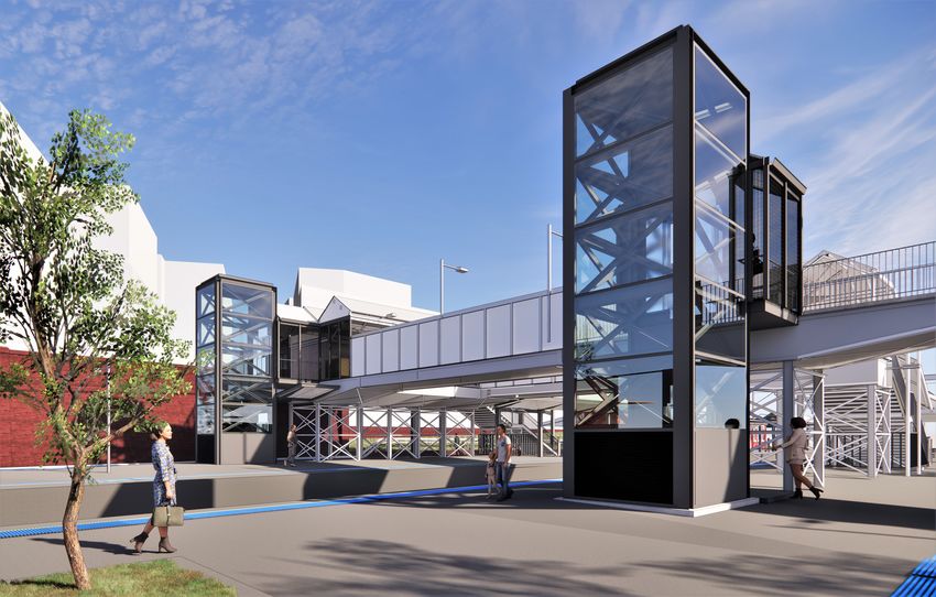
Artist’s impression of the proposed St Peters Station
Upgrade, subject to change during detailed design.
March 2021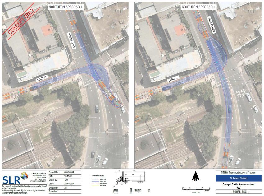
ST PETERS STATION
                                                Transport Access Program
                                Traffic, Transport and Access Assessment

                                                              Prepared for:
                                             Transport for New South Wales
                                                            7 Harvest Street
                                                            Macquarie Park
                                                                 NSW 2113

SLR Ref: 630.30084.000000-R05
Version No: -v1.0
March 2021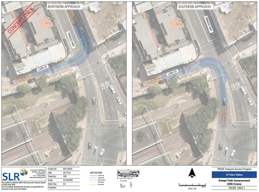
Transport for New South Wales                                                SLR Ref No: 630.30084.000000-R05-v1.0-St Peters Station-20210305 -
St Peters Station                                                                                                                        WCAG
Transport Access Program                                                                                                            March 2021
Traffic, Transport and Access Assessment

PREPARED BY
                                                  SLR Consulting Australia Pty Ltd
                                                  ABN 29 001 584 612
                                                  Tenancy 202 Submarine School, Sub Base Platypus, 120 High Street
                                                  North Sydney NSW 2060 Australia

                                                  T: +61 2 9427 8100
                                                  E: sydney@slrconsulting.com www.slrconsulting.com

BASIS OF REPORT
                                                  This report has been prepared by SLR Consulting Australia Pty Ltd (SLR) with all reasonable
                                                  skill, care and diligence, and taking account of the timescale and resources allocated to it
                                                  by agreement with Transport for New South Wales (the Client). Information reported
                                                  herein is based on the interpretation of data collected, which has been accepted in good
                                                  faith as being accurate and valid.

                                                  This report is for the exclusive use of the Client. No warranties or guarantees are
                                                  expressed or should be inferred by any third parties. This report may not be relied upon
                                                  by other parties without written consent from SLR.

                                                  SLR disclaims any responsibility to the Client and others in respect of any matters outside
                                                  the agreed scope of the work.

DOCUMENT CONTROL
 Reference                                 Date                   Prepared                  Checked                    Authorised
 630.30084.000000-R05-v1.0                 5 March 2021           Charlie Seventekin        Charlie Seventekin         Kris Stone

                                                                    Page 2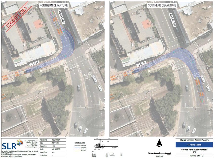
Transport for New South Wales                                 SLR Ref No: 630.30084.000000-R05-v1.0-St Peters Station-20210305 -
    St Peters Station                                                                                                         WCAG
    Transport Access Program                                                                                             March 2021
    Traffic, Transport and Access Assessment

EXECUTIVE SUMMARY

Background and upgrade work
Transport for New South Wales (Transport for NSW) has proposed the St Peters Station Upgrade (the Proposal).
The Proposal forms part of the Transport Access Program (TAP) which is a New South Wales Government
initiative to improve existing transport infrastructure, including train stations, so they are modern, accessible,
and secure. The primary aim is to provide a station precinct that is accessible to those with a disability, limited
mobility, parents / carers with prams, and customers with luggage.

The Proposal would include the following key elements:
•      two new lifts, lift landings and lift canopies at the Sydney (eastern) end of Platforms 1/2 and 3/4, connecting
       to the existing eastern footbridge
•      closure and removal of the concourse retail kiosk for the installation of a new lift servicing Platform 1/2
•      new canopies and anti-throw screens to stairs on Platform 3/4
•      new canopies along Platform 3/4 for weather protection
•      a standalone canopy at the western end of Platform 1 for weather protection at the boarding assistance
       zone (BAZ)
•      modifications to the existing footbridge safety screens at new lift interface locations
•      reconfiguration of the existing concourse building to accommodate a new family accessible toilet, new
       installation main switch board (IMSB) and existing station systems. A new switchboard would supply the
       required power to the lifts (and other station systems) from a pad mount transformer
•      provision of one kiss and ride area on Goodsell Street and two on Lord Street
•      regrading of the footpaths and landscaping work at the station entrances from Lord Street, King Street and
       Goodsell Street
•      provision of up to six additional bike hoops at Railway Lane and Lord Street
•      platform regrading and the installation of new Tactile Ground Surface Indicators (TGSI) along the platforms
•      improvements to customer information and communications systems including wayfinding modifications,
       public address (PA) system modifications and new hearing induction loops as required
•      improvements to station lighting and CCTV to improve safety and security
•      electrical upgrades and service relocations and/or adjustments to accommodate the new infrastructure,
       including replacement of an existing transformer.

Existing conditions
Station patronage data provided by Transport for NSW indicates that the average weekday passenger demand
for the AM peak hour (08:00am – 09:00am) at St Peters Station was 1,407 persons in 2017.

Existing station facilities include the following:

                                                         Page 3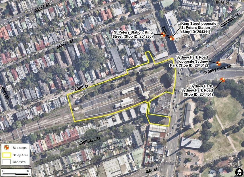
Transport for New South Wales                                  SLR Ref No: 630.30084.000000-R05-v1.0-St Peters Station-20210305 -
    St Peters Station                                                                                                          WCAG
    Transport Access Program                                                                                              March 2021
    Traffic, Transport and Access Assessment

EXECUTIVE SUMMARY
•      a concourse that is built over the rail line that can be accessed via two alleyways from Princes Highway and
       Goodsell Street
•      unsheltered bicycle parking racks near the north and south access points

The existing pedestrian footpaths constructed in the public road verges surrounding the station can generally
be described as acceptable quality although several examples were noted of localised narrowing adjacent to
utility poles, signposts, bins and fences. These localised reductions in the available path width on Lord Street
make it difficult or unfeasible for a person travelling in a wheelchair or a parent / carer walking with a pram to
navigate.

There are no formal car parks and kiss and ride areas in the vicinity of St Peters Station. There is one taxi shelter
in Goodsell Street. No illegal or informal passenger drop-off activities were observed during a site inspection
undertaken at 10:00am on Wednesday 21/10/2020. It should also be noted that no passenger drop-off demand
data was made available to SLR with respect to existing conditions.

Construction impacts
The following key construction-stage impacts are likely to be generated by the Proposal:
•      increased construction vehicle traffic including light and heavy vehicles within the station precinct and along
       proximity roads and streets including Lord Street, Princes Highway, Goodsell Street, Concord Street and Bray
       Street for movement to / from the two proposed construction compounds
•      some inconvenience for pedestrian and cyclist movements due to the construction zones and barriers along
       the footpath on Lord Street and Concord Street
•      minor parking impacts on Lord Street near Princes Highway intersection and the construction compound - 2
•      minor impacts on traffic flow and performance of nearby intersections
•      closures of roads, cycleways and foot paths for short periods to enable the installation of lift shafts
•      potential confusion and loss of amenity to customers accessing the station via temporary and changed
       facilities during construction
•      short-term occupation of kerbside parking spaces, cycleways and foot paths by heavy vehicles facilitating
       construction
•      minor travel delays on account of likely TCP implementation requiring general traffic, public transport,
       cyclists, and pedestrians to stop for construction traffic.

Construction impacts are considered to be manageable subject to the preparation and implementation of a
Construction Traffic Management Plan (CTMP). The CTMP and subordinate Traffic Control Plans (TCPs) should
review issues and identify solutions and temporary arrangements to avoid, mitigate and manage risk involving
construction activities, users of the transport system, and residents.

                                                          Page 4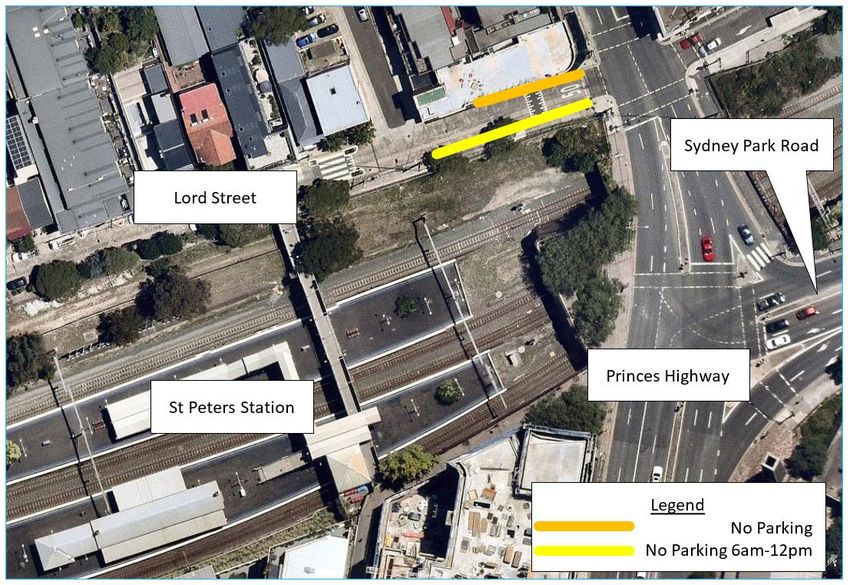
Transport for New South Wales                                 SLR Ref No: 630.30084.000000-R05-v1.0-St Peters Station-20210305 -
 St Peters Station                                                                                                         WCAG
 Transport Access Program                                                                                             March 2021
 Traffic, Transport and Access Assessment

EXECUTIVE SUMMARY

Operational impacts
Forecast station patronage data provided by Transport for NSW indicates that the St Peters Station annual
customer demand will increase by 13.5% between 2017 and 2036 from 1,407 persons to 1,597 persons for the
AM peak hour (08:00am – 09:00am). An additional 15% has also been evaluated as a ‘factor of safety’ to ensure
a conservative assessment. As such, the forecast daily design patronage for a 2036-time horizon is 1,837 persons.

The Proposal would enable more direct, legible, and safe pedestrian routes in the immediate vicinity of the
station. The Proposal would also improve compliance with the Disability Discrimination Act (DDA) and Disability
Standards for Accessible Public Transport (DSAPT). Overall, the user experience including amenity and
convenience would be improved.

The existing transport and interchange facilities would be enhanced through improved geometry, line marking
and wayfinding signage as part of the Proposal. The Proposal would provide three kiss and ride areas and six
additional bicycle parking hoops in the same general locale.

Changes to existing traffic capacity and performance are projected to be insignificant given the relatively minor
nature and scale of the improvements delivered as part of the Proposal. Whilst there would be some increase
in station utilisation as a result of improvements to accessibility and amenity, it is expected that these
incremental increases would not result in a material increase in traffic demand or road network performance.

                                                      Page 5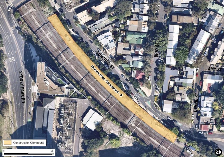
Transport for New South Wales                                                                        SLR Ref No: 630.30084.000000-R05-v1.0-St Peters Station-20210305 -
St Peters Station                                                                                                                                                WCAG
Transport Access Program                                                                                                                                    March 2021
Traffic, Transport and Access Assessment

      CONTENTS
      GLOSSARY OF TERMS ............................................................................................................... 9
      1              INTRODUCTION ..................................................................................................... 11
      1.1            Background ..................................................................................................................... 11
      1.2            Transport Access Program objectives ............................................................................. 11
      1.3            More Trains, More Services Program ............................................................................. 11
      1.4            Proposal overview .......................................................................................................... 11
      1.5            Objectives of this proposal ............................................................................................. 14
      1.6            Study scope ..................................................................................................................... 14
      1.7            Study area ....................................................................................................................... 14
      1.8            References ...................................................................................................................... 15
      2              EXISTING CONDITIONS ASSESSMENT...................................................................... 16
      2.1            Surrounding land uses .................................................................................................... 16
      2.2            Movement network ........................................................................................................ 17
      2.3            Station access and facilities ............................................................................................ 18
      2.3.1          Station facilities ............................................................................................................................................ 18
      2.3.2          Pedestrians ................................................................................................................................................... 18
      2.3.2.1        St Peters Station access ................................................................................................................................ 18
      2.3.2.2        Local pedestrian infrastructure .................................................................................................................... 19
      2.3.2.3        Pedestrian demand Study ............................................................................................................................ 20
      2.3.3          Cyclists .......................................................................................................................................................... 20
      2.3.3.1        St Peters Station access ................................................................................................................................ 20
      2.3.3.2        Local cycling infrastructure........................................................................................................................... 21

      2.4            External transport network and interchange facilities ................................................... 23
      2.4.1          Rail ................................................................................................................................................................ 23
      2.4.1.1        Services......................................................................................................................................................... 23
      2.4.1.2        Patronage ..................................................................................................................................................... 24
      2.4.2          Bus ................................................................................................................................................................ 24
      2.4.2.1        Services and Stops ........................................................................................................................................ 24
      2.4.3          Kiss and ride and taxi zone ........................................................................................................................... 26
      2.4.3.1        Facilities ........................................................................................................................................................ 26
      2.4.4          Parking .......................................................................................................................................................... 27

      2.5            Road safety ..................................................................................................................... 27
      3              PROPOSAL DESCRIPTION ....................................................................................... 30
      3.1            Station access upgrades.................................................................................................. 30

                                                                                         Page 6
Transport for New South Wales                                                                      SLR Ref No: 630.30084.000000-R05-v1.0-St Peters Station-20210305 -
St Peters Station                                                                                                                                              WCAG
Transport Access Program                                                                                                                                  March 2021
Traffic, Transport and Access Assessment

      CONTENTS
      3.2            Station building and platform modifications .................................................................. 30
      3.3            Ancillary work ................................................................................................................. 30
      3.4            Interchange facilities including external movement networks ...................................... 31
      3.4.1          Pedestrians ................................................................................................................................................... 31
      3.4.2          Bicycle parking .............................................................................................................................................. 31
      3.4.3          Public transport ............................................................................................................................................ 31
      3.4.4          Kiss and ride and taxi facilities ...................................................................................................................... 31
      3.4.5          Parking .......................................................................................................................................................... 31

      4              CONSTRUCTION IMPACTS ...................................................................................... 32
      4.1            Construction work and compounds................................................................................ 32
      4.2            Hours of work ................................................................................................................. 35
      4.3            Construction timing ........................................................................................................ 35
      4.4            Haulage Routes ............................................................................................................... 37
      4.5            Construction Vehicles Access ......................................................................................... 38
      4.5.1          Access to Construction Compound - 1 ......................................................................................................... 38
      4.5.2          Access to Construction Compound - 2 ......................................................................................................... 43

      4.6            Active transport impacts................................................................................................. 44
      4.7            Public transport impacts ................................................................................................. 45
      4.8            Traffic impacts ................................................................................................................ 45
      4.9            Parking impacts............................................................................................................... 45
      4.10           Kiss and ride and taxi impacts......................................................................................... 46
      4.11           Property access impacts ................................................................................................. 46
      4.12           Construction impact mitigation ...................................................................................... 46
      5              OPERATIONAL IMPACTS ........................................................................................ 48
      5.1            Future demand ............................................................................................................... 48
      5.2            Public transport .............................................................................................................. 48
      5.3            Pedestrians ..................................................................................................................... 48
      5.3.1          Pedestrian improvements ............................................................................................................................ 48
      5.3.2          Capacity assessment .................................................................................................................................... 49

      5.4            Cyclists ............................................................................................................................ 50
      5.5            Kiss and ride and taxi facilities ........................................................................................ 50
      5.6            Parking ............................................................................................................................ 50
      5.7            Traffic impacts ................................................................................................................ 50

                                                                                        Page 7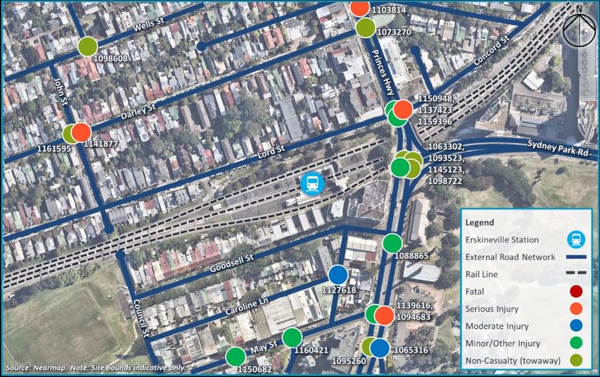
Transport for New South Wales                                                         SLR Ref No: 630.30084.000000-R05-v1.0-St Peters Station-20210305 -
St Peters Station                                                                                                                                 WCAG
Transport Access Program                                                                                                                     March 2021
Traffic, Transport and Access Assessment

      CONTENTS
      5.8            Property access ............................................................................................................... 50
      5.9            Safety .............................................................................................................................. 50
      6              SUMMARY, CONCLUSIONS AND RECOMMENDATIONS ........................................... 51

DOCUMENT REFERENCES
      TABLES
      Table 1:         Surrounding road network characteristics ................................................................... 18
      Table 2:         St Peters Station service frequency ............................................................................. 24
      Table 3:         St Peters Station nearby bus services (stop ID: 207332).............................................. 26
      Table 4:         Transport for NSW crash history in the vicinity of St Peters Station ........................... 29
      Table 5:         Indicative construction staging for key activities ......................................................... 37
      Table 6:         Proposed Haulage Routes ............................................................................................ 37
      Table 7:         Summary of swept path assessments near St Peters Station ...................................... 44
      Table 8:         St Peters Station patronage demand and forecasts .................................................... 48
      Table 9:         Pedestrian level of service using the Fruin Theory ...................................................... 49

      FIGURES
      Figure 1:        Proposed General Station Schematic ........................................................................... 13
      Figure 2:        Proposed General Station Layout – Axonometric View ............................................... 13
      Figure 3:        St Peters Station study area ......................................................................................... 15
      Figure 4:        Surrounding land uses .................................................................................................. 16
      Figure 5:        Local context and surrounding road network .............................................................. 17
      Figure 6:        Access stairs to platforms at St Peters Station............................................................. 19
      Figure 7:        Local pedestrian infrastructure .................................................................................... 20
      Figure 8:        Cycling infrastructure – local context........................................................................... 21
      Figure 9:        Cycling infrastructure – regional context ..................................................................... 22
      Figure 10:       New pop-up cycleway on Sydney Park Road ............................................................... 22
      Figure 11:       Location of St Peters Station within Sydney Trains network ....................................... 23
      Figure 12:       Bus stops in the vicinity of St Peters Station ................................................................ 25
      Figure 13:       No Parking Zones (Informal kiss and ride areas) near St Peters Station ...................... 27
      Figure 14:       Transport for NSW crash history near St Peters Station .............................................. 28
      Figure 15:       Construction compound 1 within Railway Reserve off Lord Street ............................. 33
      Figure 16:       Construction compound 2 within railway corridor off Concord Street ....................... 34
      Figure 17:       Proposed Haulage Routes for 19m Articulated Vehicles ............................................. 38
      Figure 18:       Access to construction compound – 1 ......................................................................... 39
      Figure 19:       Access to construction compound - 1 .......................................................................... 39
      Figure 20:       Access to construction compound – 2 ......................................................................... 40
      Figure 21:       HRV (12.5 metre) swept path assessment at construction compound - 1 .................. 41
      Figure 22:       HRV (12.5 metre) swept path assessment at Princes Hwy and Lord St
                       intersection .................................................................................................................. 41

                                                                            Page 8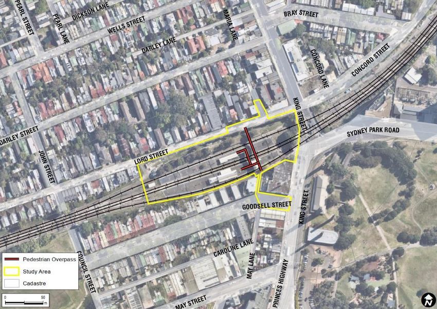
Transport for New South Wales                                                     SLR Ref No: 630.30084.000000-R05-v1.0-St Peters Station-20210305 -
St Peters Station                                                                                                                             WCAG
Transport Access Program                                                                                                                 March 2021
Traffic, Transport and Access Assessment

        CONTENTS
        Figure 23:     200-tonnes crane (14.7 metre) swept path assessment at construction
                       compound – 1 .............................................................................................................. 42
        Figure 24:     Delivery of Lift Shafts with an AV ................................................................................. 42
        Figure 25:     HRV (12.5m) swept path assessment at construction compound - 2 .......................... 43

        APPENDICES
        Appendix A Swept Path Assessments

Glossary of terms
Term
                  Term Meaning
Meaning
AADT              Annual Average Daily Traffic
ABS               Australian Bureau of Statistics
AS                Australian Standards
ASA               Asset Standards Authority
BTS               Bureau of Transport Statistics, a division of Transport for NSW
CBD               Central Business District
CTMP              Construction Traffic Management Plan
DDA               Disability Discrimination Act 1992 (Commonwealth)
DP&E              New South Wales – Department of Planning and Environment
DSAPT             Disability Standards for Accessible Public Transport
                  John J Fruin, who pioneered studies on pedestrian flows and crowding levels. Fruin defined six levels of
Fruin
                  crowding for queueing areas, walkways, and stairways, and given in terms of Levels of Service (LOS).
HV                Heavy vehicles
                  Infrastructure and Services, a division of Transport for NSW (formerly Transport Projects
I&S
                  Division)
JTW               Journey to Work
LEP               Local Environmental Plan
LGA               Local Government Area
                  Level of Service – a qualitative measure of flow and crowding, with LOS A as the
LOS
                  ‘most pleasant’ and F the ‘least pleasant’ in terms of pedestrian flow and crowding.
m                 metres
mm                millimetres
NSW               State of New South Wales
OOHW              Out of Hours Work
PEA               Preliminary Environmental Assessment
PLC               Presbyterian Ladies College

                                                                         Page 9
Transport for New South Wales SLR Ref No: 630.30084.000000-R05-v1.0-St Peters Station-20210305 -
St Peters Station WCAG
Transport Access Program March 2021
Traffic, Transport and Access Assessment
CONTENTS
Term
Term Meaning
Meaning
pmm pedestrians per metre per minute, a measure of pedestrian flow rate
Possession is the term used by railway building/maintenance contractors to indicate that they have
Rail
taken possession of the track (usually a block of track) for a specified period, so that no trains operate
possession
for a specified time. This is necessary to ensure the safety of workers and rail users.
RailCorp Rail Corporation New South Wales (now Sydney Trains)
REF Review of Environmental Factors
Roads Act Roads Act 1993 (NSW)
TAP Transport Access Program
TCP Traffic Control Plan
TfNSW Transport for New South Wales
TT&AIA Traffic, Transport and Access Impact Assessment (this report)
TGSI Tactile Ground Surface Indicator
TZ Travel zone – a geographical unit used as a basis for travel data analysis and statistics.
Page 10Transport for New South Wales SLR Ref No: 630.30084.000000-R05-v1.0-St Peters Station-20210305 -
St Peters Station WCAG
Transport Access Program March 2021
Traffic, Transport and Access Assessment
1 Introduction
1.1 Background
Transport for NSW is responsible for strategy, planning, policy, procurement, regulation, funding allocation and
other non-service delivery functions for all modes of transport in NSW including road, rail, ferry, light rail, point
to point, cycling and walking.
Transport for NSW is the proponent for the St Peters Station Upgrade (the ‘Proposal’).
The NSW Government is committed to facilitating and encouraging the use of public transport, such as trains,
by upgrading stations to make them more accessible, and improving interchanges around stations with other
modes of transport such as buses, bicycles, and cars. The NSW Government is also committed to building a
modern and up-to-date rail system that will play its part in making Sydney a more productive and liveable city.
1.2 Transport Access Program objectives
The St Peters Station Upgrade, the subject of this Review of Environmental Factors (REF), forms part of the
Transport Access and More Trains More Services programs.
The Transport Access Program is an NSW Government initiative to provide a better experience for public
transport customers by delivering accessible, modern, secure, and integrated transport infrastructure. The More
Trains, More Services Program will transform the rail network and provide customers with more reliable, high
capacity turn up and go services.
The Proposal would improve accessibility of the station in line with the requirements of the Commonwealth
Disability Discrimination Act 1992 (DDA) and the Disability Standards for Accessible Public transport 2020
(DSAPT). The Proposal would also ensure that customers at the station receive a continuing level of amenity,
safety and comfort whilst improving timetable reliability.
1.3 More Trains, More Services Program
St Peters Station Upgrade also forms part of the More Trains, More Services Program, which is a program of
staged investments that will progressively transform the rail network into a modern and reliable mass transit
system using world class digital technology. The program is already delivering better customer outcomes
through timetable enhancements and integration of Sydney Metro Northwest with the heavy rail network. The
current stage of the More Trains, More Services Program will focus on delivering greater capacity, reliability and
connectivity for customers on the T4 Eastern Suburbs & Illawarra Line, South Coast Line and T8 Airport and
South Line.
As part of the broader network re-configuration strategy, customers will board and alight trains at St Peters from
different platforms and these alternative platforms do not currently have sufficient canopy cover for customer
amenity. The Proposal involves canopy upgrades to platforms at these stations to ensure that customers receive
a continuing level of amenity, safety and comfort and spread evenly along the platform.
1.4 Proposal overview
The Proposal involves an upgrade of St Peters Station which would improve accessibility and amenity for
customers.
Page 11Transport for New South Wales SLR Ref No: 630.30084.000000-R05-v1.0-St Peters Station-20210305 -
St Peters Station WCAG
Transport Access Program March 2021
Traffic, Transport and Access Assessment
The Proposal would include the following elements:
• two new lifts, lift landings and lift canopies at the Sydney (eastern) end of Platforms 1/2 and 3/4, connecting
to the existing eastern footbridge
• closure and removal of the concourse retail kiosk for the installation of a new lift servicing Platform 1/2
• new canopies and anti-throw screens to stairs on Platform 3/4
• new canopies along Platform 3/4 for weather protection
• a standalone canopy at the western end of Platform 1 for weather protection at the boarding assistance
zone (BAZ)
• modifications to the existing footbridge safety screens at new lift interface locations
• reconfiguration of the existing concourse building to accommodate a new family accessible toilet, new
installation main switch board (IMSB) and existing station systems. A new switchboard that will supply the
required power to the lifts (and other station systems) from a pad mount transformer
• provision of one kiss and ride area on Goodsell Street and two on Lord Street
• regrading of the footpaths and landscaping work at the station entrances from Lord Street, King Street and
Goodsell Street
• provision of up to six additional bike hoops at Railway Lane and Lord Street
• improvements to customer information and communications systems including wayfinding modifications,
public address (PA) system modifications and new hearing induction loops as required
• platform regrading and the installation of new Tactile Ground Surface Indicators (TGSI) along the platforms
• improvements to station lighting and CCTV to improve safety and security
• electrical upgrades and service relocations and/or adjustments to accommodate the new infrastructure,
including replacement of an existing transformer.
Figure 1 and Figure 2 show the general layout of key elements for the Proposal.
Page 12Transport for New South Wales SLR Ref No: 630.30084.000000-R05-v1.0-St Peters Station-20210305 -
St Peters Station WCAG
Transport Access Program March 2021
Traffic, Transport and Access Assessment
Figure 1: Proposed General Station Schematic
Source: TfNSW, February 2021
Figure 2: Proposed General Station Layout – Axonometric View
Source: Urban Design and Public Domain Plan: St Peters Station, Laing O’Rourke, December 2020
Page 13Transport for New South Wales SLR Ref No: 630.30084.000000-R05-v1.0-St Peters Station-20210305 -
St Peters Station WCAG
Transport Access Program March 2021
Traffic, Transport and Access Assessment
1.5 Objectives of this proposal
The specific objectives of the Proposal are as follows:
• provide a station that is accessible to those with a disability, the ageing and parents / carers with prams and
customers with luggage
• improve customer experience (weather protection, better interchange facilities and visual appearance)
• minimise pedestrian conflict and crowding points
• improve integration with surrounding precinct
• improve customer safety
• improve wayfinding in and around the station
• respond to the heritage values of the site
• improve customer amenity.
1.6 Study scope
SLR Consulting (SLR) has been commissioned by Transport for NSW to prepare this Traffic, Transport and Access
Impact Assessment which would form part of the REF for the Proposal. This report assesses the anticipated
traffic, transport and access impacts associated with the Proposal. The following matters are addressed as part
of this assessment:
• existing traffic, transport and access conditions and facilities
• operational traffic impacts associated with the proposed facilities
• construction impacts associated with the Proposal
• potential mitigation measures recommended to avoid, mitigate or manage impacts.
This assessment has been prepared noting the following:
• stakeholder consultation was not conducted by SLR as part of this study
• construction activity assumptions were provided by Transport for NSW
• no traffic modelling or pedestrian count surveys were completed as part of this project, nor by other
consultants during the concept design development phase given the Proposal is not anticipated to change
existing, or generate any significant additional, vehicle and pedestrian traffic demand.
1.7 Study area
St Peters Station is located approximately 5.5 kilometres south of the Sydney CBD and within the local
government jurisdiction of the Inner West Council. The station is situated in St Peters and bordered by Newtown
and Erskineville.
The study area incorporates the station, the immediate fronting roads of Princes Highway / King Street and Lord
Street as well as the intersection of Princes Highway / King Street / Sydney Park Road, surrounding footpath
system, and two proposed construction compounds in relation to the Proposal.
The area and transport systems surrounding the study area have also been considered, however these are not
the primary area influenced by the Proposal.
Page 14Transport for New South Wales SLR Ref No: 630.30084.000000-R05-v1.0-St Peters Station-20210305 -
St Peters Station WCAG
Transport Access Program March 2021
Traffic, Transport and Access Assessment
The study area adopted by SLR is illustrated in Figure 3.
Figure 3: St Peters Station study area
Base map source: Nearmap, 2020
1.8 References
The following has been relied upon and / or referenced in undertaking this assessment:
• a site inspection undertaken by SLR staff on Wednesday 21st of October 2020
• Australian Standards AS2890 – Part 5 (2020): On-street car parking
• Australian Standards AS2890 – Part 6 (2009): Off-street car parking for people with disabilities
• St Peters Station Design Report, Arcadis, dated 20/11/2020
• Architectural Drawings, Laing O’Rourke, dated 20/11/2020
• RailCorp (May 2010). Engineering Standard: Stations and Buildings – Station Design Standard Requirements:
ESB 003 – Station Functional Spaces.
Page 15Transport for New South Wales SLR Ref No: 630.30084.000000-R05-v1.0-St Peters Station-20210305 -
St Peters Station WCAG
Transport Access Program March 2021
Traffic, Transport and Access Assessment
2 Existing conditions assessment
2.1 Surrounding land uses
Located within the Inner West Council LGA, the subject site is bound by the provisions of the Marrickville Local
Environment Plan (LEP) 2011 and the Marrickville Development Control Plan (DCP) 2011. It should also be noted
that the Inner West Council has commenced preparation of the draft Inner West Local Environment Plan (LEP)
2020 which consolidates the three existing LEPs for the former Ashfield, Leichhardt and Marrickville LGAs,
following their amalgamation.
The Marrickville LEP 2011 Land Zoning Map Sheet LZN_004 designates the land on which the station is located
as ‘SP2 Infrastructure’ and defines Princess Highway / King Street as classified roads whilst Lord Street is a local
road.
Land surrounding the station is mainly classified as “R2 – low density residential”, “R4 – high density residential”,
“SP2 – Infrastructure” and “RE1 – Public Creation”.
An extract from the Marrickville LEP 2011 map is provided in Figure 4.
Figure 4: Surrounding land uses
Base map source: Nearmap, 2020
Page 16Transport for New South Wales SLR Ref No: 630.30084.000000-R05-v1.0-St Peters Station-20210305 -
St Peters Station WCAG
Transport Access Program March 2021
Traffic, Transport and Access Assessment
2.2 Movement network
St Peters Station is surrounded by Princes Highway (State Road A36) to the east and Lord Street (local road) to
the north. There are three pedestrian access points to St Peters Station:
• Princes Highway via an alleyway
• Goodsell Street via an alleyway
• direct access from Lord Street.
The location of the station within the local road network is shown in Figure 5 and the characteristics of the
nearby key roads and streets are summarised in Table 1.
Figure 5: Local context and surrounding road network
Base map source: Nearmap, 2020
Page 17Transport for New South Wales SLR Ref No: 630.30084.000000-R05-v1.0-St Peters Station-20210305 -
St Peters Station WCAG
Transport Access Program March 2021
Traffic, Transport and Access Assessment
Road Name Posted Speed Limit School Zone Configuration
7 marked lanes, divided carriageway, no stopping and clearway
Princes Highway Arterial Road: restrictions apply in the weekday peak traffic hours.
No
(State Road A36) 60km/h Station frontage: Princes Highway / King Street / Sydney Park Road
signalised intersection
1 unmarked lane, one-way traffic, typically unrestricted parking on
Lord Street Local Road: 50km/h No southern side of carriageway and 1P parking on the northern side
of carriageway.
2 unmarked lanes, undivided carriageway, typically short-term
Goodsell Street Local Road: 50km/h No parking (excludes parking permit holders) on either side of the
carriageway.
Alleyway –
May Lane Pedestrians and No Approximately 3.5-metre-wide alleyway with no vehicular traffic.
Cyclists only
Table 1: Surrounding road network characteristics
2.3 Station access and facilities
2.3.1 Station facilities
The following accessibility and convenience features are currently installed at the station:
• Opal integrated ticketing card top-up systems
• emergency help point
• hearing loop
• a public address (PA) system to broadcast audible / verbal announcements to passengers.
2.3.2 Pedestrians
2.3.2.1 St Peters Station access
There are three pedestrian access points to St Peters Station, being from Lord Street, Goodsell Street and Princes
Highway. All three accesses require users to navigate stairs in order to reach train platforms as indicated in
Figure 6.
Page 18Transport for New South Wales SLR Ref No: 630.30084.000000-R05-v1.0-St Peters Station-20210305 -
St Peters Station WCAG
Transport Access Program March 2021
Traffic, Transport and Access Assessment
Figure 6: Access stairs to platforms at St Peters Station
Given the lack of ramps or lifts, the St Peters Station does not currently accommodate persons with a disability,
mobility impaired or elderly persons, or parents and carers with prams and is not DSAPT compliant.
2.3.2.2 Local pedestrian infrastructure
There are pedestrian footpaths on either side of Princes Highway, Goodsell Street and Lord Street. The verge
adjacent to the Princes Highway station entrance accommodates a pocket park where there are a number of
trees and a bench providing some recreational space to the members of the community.
The footpath network surrounding the station has the following attributes:
• Princes Highway – approximately 3.5-metre-wide footpath on both sides of the carriageway (a railway
overpass)
• Lord Street – approximately two-metre-wide footpath on the southern side and 1.5-metre-wide footpath
on the northern side of the carriageway with a number of impediments (i.e. signposts, power poles,
residents’ rubbish bins)
• Goodsell Street – approximately two-metre-wide footpath on the southern side and approximately three-
metre-wide footpath on the northern side of the carriageway.
The extent of the surrounding pedestrian infrastructure is illustrated in Figure 7.
Page 19Transport for New South Wales SLR Ref No: 630.30084.000000-R05-v1.0-St Peters Station-20210305 -
St Peters Station WCAG
Transport Access Program March 2021
Traffic, Transport and Access Assessment
Figure 7: Local pedestrian infrastructure
Base map source: Nearmap, 2020
2.3.2.3 Pedestrian demand Study
No pedestrian count survey data was collected as part of the assessment for Princes Highway, Goodsell Street
and Lord Streets; however, very low pedestrian activity was observed during the site inspection on Wednesday,
21st of October 2020. This could be associated with the ongoing COVID-19 pandemic.
2.3.3 Cyclists
2.3.3.1 St Peters Station access
At present, there are no means of transporting a bicycle to the station platform without having to carry it down
(and up) a flight of stairs.
There is a total of five bicycle parking racks available at Railway Lane (three) and Lord Street (two) access points
at St Peters Station. It is anticipated that these five racks can accommodate up to 10 bicycles.
Page 20Transport for New South Wales SLR Ref No: 630.30084.000000-R05-v1.0-St Peters Station-20210305 -
St Peters Station WCAG
Transport Access Program March 2021
Traffic, Transport and Access Assessment
2.3.3.2 Local cycling infrastructure
Based on the information obtained through City of Sydney Council’s website1, cycleways within the proximity of
St Peters Station have continuous and direct linkages to Sydney CBD and are equipped with wayfinding signage.
Figure 8 and Figure 9 provide an outline of the local and regional cycling infrastructure, respectively.
Figure 8: Cycling infrastructure – local context
Source: City of Sydney Council Website, November 2020
1 https://www.cityofsydney.nsw.gov.au/lists-maps-inventories/sydney-cycling-map
Page 21Transport for New South Wales SLR Ref No: 630.30084.000000-R05-v1.0-St Peters Station-20210305 -
St Peters Station WCAG
Transport Access Program March 2021
Traffic, Transport and Access Assessment
Figure 9: Cycling infrastructure – regional context
Source: City of Sydney Council Website, November 2020
Figure 10: New pop-up cycleway on Sydney Park Road
Base map source: Nearmap, 2020
Page 22Transport for New South Wales SLR Ref No: 630.30084.000000-R05-v1.0-St Peters Station-20210305 -
St Peters Station WCAG
Transport Access Program March 2021
Traffic, Transport and Access Assessment
2.4 External transport network and interchange facilities
2.4.1 Rail
2.4.1.1 Services
St Peters Station is part of T3 Bankstown Line and T8 Airport and South Line. The station is well serviced by
frequent trains travelling between Bankstown and Lidcombe, Central Station.
Figure 11 provides an overview of T3 Bankstown Line.
Figure 11: Location of St Peters Station within Sydney Trains network
Source: https://transportnsw.info/sydney-trains-network-map
Page 23Transport for New South Wales SLR Ref No: 630.30084.000000-R05-v1.0-St Peters Station-20210305 -
St Peters Station WCAG
Transport Access Program March 2021
Traffic, Transport and Access Assessment
Service frequency of St Peters Station is summarised in Table 2.
Destination Operating Days Service Frequency
Peak: approx. 5-10 mins
Monday to Friday
T3 - Central / Bankstown Off-peak: approx. 15 mins
Weekends and public holidays approx. 15 mins
Peak: approx. 15 mins
Monday to Friday
T8 – Central / Macarthur Off-peak: No service
(South)
Weekends and public holidays No service
Table 2: St Peters Station service frequency
Source - 1: https://transportnsw.info/documents/timetables/93-T3-Bankstown-Line-20201025-20210227.pdf
Source - 2: https://transportnsw.info/documents/timetables/93-T8-Airport-South-Line-20201025-20210227.pdf
2.4.1.2 Patronage
Station patronage data provided by Transport for NSW indicates that the average weekday passenger demand
for the AM peak hour (08:00am – 09:00am) at St Peters Station was 1,407 persons in 2017.
2.4.2 Bus
2.4.2.1 Services and Stops
There are four bus stops in close proximity to St Peters Station, as follows:
• two bus stops on King Street, to the north of St Peters Station (stop ID: stop ID: 204230 in the northbound
direction and 204311 in the southbound direction)
• two bus stops on Sydney Park Road, to the east of St Peters Station (stop ID: 204312 in the eastbound
direction and stop ID: 204451 in the westbound direction).
The locations of these stops are shown in Figure 12.
Page 24Transport for New South Wales SLR Ref No: 630.30084.000000-R05-v1.0-St Peters Station-20210305 -
St Peters Station WCAG
Transport Access Program March 2021
Traffic, Transport and Access Assessment
Figure 12: Bus stops in the vicinity of St Peters Station
Base map source: Nearmap, 2020
Table 3 summarises the public bus routes that service these bus stops.
Page 25Transport for New South Wales SLR Ref No: 630.30084.000000-R05-v1.0-St Peters Station-20210305 -
St Peters Station WCAG
Transport Access Program March 2021
Traffic, Transport and Access Assessment
Approximate Off-
Approximate Peak
Service Route Bus Stop ID Peak Hour
Hour Frequency
Frequency
Marrickville Metro to Central Eddy 204312
308 15 minutes 30 minutes
Avenue via Redfern 204451
204312
348 Wolli Creek to Bondi Junction 10 minutes N/A
204451
204230
370 Coogee to Leichhardt Marketplace 10 minutes 30 minutes
204311
204230
422 Kogarah to Central Pitt Street 10 minutes 30minutes
204311
Table 3: St Peters Station nearby bus services (stop ID: 207332)
Source: https://transportnsw.info/routes/bus
2.4.3 Kiss and ride and taxi zone
2.4.3.1 Facilities
A site inspection and desktop analysis revealed that there are two sections of kerbside parking in Lord Street
which can be used as informal kiss and ride areas in the vicinity of St Peters Station. Applicable restrictions at
these two locations are “No Parking” which permits a vehicle to stand for up to 2-minutes as per NSW Parking
Rules2. Mobility parking permit holders can legally park at this location for up to 5-minutes.
However, there are no formal kiss and ride areas dedicated to pick-up and drop-off activities. The two informal
pick-up and drop-off facilities in Lord Street are shown in Figure 13. Lord Street is one-way traffic and as such
may not be a suitable kiss and ride for some users.
2 https://www.rms.nsw.gov.au/roads/safety-rules/road-rules/parking.html
Page 26Transport for New South Wales SLR Ref No: 630.30084.000000-R05-v1.0-St Peters Station-20210305 -
St Peters Station WCAG
Transport Access Program March 2021
Traffic, Transport and Access Assessment
Figure 13: No Parking Zones (Informal kiss and ride areas) near St Peters Station
Base map source: Nearmap, 2020
There is currently one taxi shelter within the vicinity of St Peters Station, located in Goodsell Street.
2.4.4 Parking
There is no commuter car parking facility available to the users of St Peters Station. A number of streets in the
vicinity of St Peters Station provide unrestricted parking, however on-street parking in the morning peak hour
near St Peters Station is typically limited.
2.5 Road safety
Crash statistics from the Transport for NSW Centre for Road Safety suggest that there were four reported crashes
that resulted in serious injuries in the study area between 2014 and 2018. No fatal crashes were recorded.
A total of 20 incidents were noted for the period 2014-2018. A summary of this crash history is illustrated in
Figure 14.
Page 27Transport for New South Wales SLR Ref No: 630.30084.000000-R05-v1.0-St Peters Station-20210305 -
St Peters Station WCAG
Transport Access Program March 2021
Traffic, Transport and Access Assessment
Figure 14: Transport for NSW crash history near St Peters Station
Source: Transport for NSW, 2020
A detailed summary of this crash history and causes of crashes are provided in Table 4.
Road User
Location Crash ID Year Severity Movement (RUM) Description
Code3
May Street / Applebee Minor/Other Left off carriageway into
1160421 2018 71
Street Injury object/parked vehicle
May Lane / Caroline Moderate Playing, working, lying, standing
1127618 2016 3
Lane Injury on carriageway
Darley Street / John Non-Casualty Left off carriageway into
1161595 2017 71
Street (towaway) object/parked vehicle
Darley Street / John
1141877 2017 Serious Injury 10 Cross traffic
Street
Wells Street / Pearl Non-Casualty Right off carriageway into object
1098608 2016 73
Street (towaway) parked vehicle
Princes Hwy / Bray
1103814 2016 Serious Injury 34 Lane change right
Street
3 https://roadsafety.transport.nsw.gov.au/statistics/interpret-data.html
Page 28Transport for New South Wales SLR Ref No: 630.30084.000000-R05-v1.0-St Peters Station-20210305 -
St Peters Station WCAG
Transport Access Program March 2021
Traffic, Transport and Access Assessment
Road User
Location Crash ID Year Severity Movement (RUM) Description
Code3
Princes Hwy / Darley Non-Casualty
1073270 2015 30 Rear end
Street (towaway)
Princes Hwy / Lord
1150948 2017 Serious Injury 0 Near side
Street / Concord Street
Princes Hwy / Lord Minor/Other
1137423 2017 30 Rear end
Street / Concord Street Injury
Princes Hwy / Lord Minor/Other
1159396 2018 10 Cross traffic
Street / Concord Street Injury
Princes Hwy / Sydney Non-Casualty
1063302 2015 32 Right rear
Park Road (towaway)
Princes Hwy / Sydney Non-Casualty
1093523 2016 39 Other same direction
Park Road (towaway)
Princes Hwy / Sydney Non-Casualty
1145123 2017 39 Other same direction
Park Road (towaway)
Princes Hwy / Sydney Minor/Other
1098722 2016 30 Rear end
Park Road Injury
Princes Hwy / Goodsell Minor/Other
1088865 2015 47 Emerging from drive
Street Injury
Princes Hwy / May
1094683 2016 Serious Injury 30 Rear end
Street
Princes Hwy / May Minor/Other
1139616 2017 16 Left near
Street Injury
Princes Hwy / Access Moderate
1065316 2015 13 Right near
Road Injury
Princes Hwy / Access Non-Casualty
1095260 2016 21 Right through
Road (towaway)
Minor/Other
May Street 1150682 2017 30 Rear end
Injury
Table 4: Transport for NSW crash history in the vicinity of St Peters Station
Source: Transport for NSW, 2020
A review of the recent crash data indicated that rear-end crashes were the main type of recurring crashes in the
vicinity of St Peters Station. There was a recorded crash involving a pedestrian in 2018 (crash ID: 1159696). The
RUM code indicates that this pedestrian was crossing Princes Highway near Lord Street intersection. Crash data
also indicated that there were no reported crashes on Lord Street and Goodsell Street.
Page 29Transport for New South Wales SLR Ref No: 630.30084.000000-R05-v1.0-St Peters Station-20210305 -
St Peters Station WCAG
Transport Access Program March 2021
Traffic, Transport and Access Assessment
3 Proposal description
3.1 Station access upgrades
Details of the proposed works to take place at the station to improve accessibility are as follows:
• installation of two new lifts, lift landings and lift canopies at the Sydney (eastern) end of Platforms 1/2 and
3/4, connecting to the existing eastern footbridge
• provision of one kiss and ride area on Goodsell Street and two on Lord Street
• regrading of the footpaths and landscaping work at the station entrances from Lord Street, King Street and
Goodsell Street
• provision of up to six additional bike hoops at Railway Lane and Lord Street
• platform regrading and the installation of new TGSI along the platforms.
3.2 Station building and platform modifications
Modifications to the station buildings would include:
• closure and removal of the concourse retail kiosk for the installation of a new lift servicing Platform 1/2
• new canopies and anti-throw screens to stairs on Platform 3/4
• new canopies along Platform 3/4 for weather protection
• a standalone canopy at the western end of Platform 1 for weather protection at the BAZ
• modifications to the existing footbridge safety screens at new lift interface locations
• reconfiguration of the existing concourse building to accommodate a new family accessible toilet, new IMSB
and existing station systems. A new switchboard would supply the required power to the lifts (and other
station systems) from a pad mount transformer
• improvements to customer information and communications systems including wayfinding modifications,
PA system modifications and new hearing induction loops as required
• improvements to station lighting and CCTV to improve safety and security
• electrical upgrades and service relocations and/or adjustments to accommodate the new infrastructure,
including replacement of an existing transformer.
3.3 Ancillary work
The following ancillary works required as part of the upgrade work would include:
• regarding and resurfacing of localised areas on the platforms to provide compliant paths of travel between
the lift, boarding assistance zones, family accessible toilet and other facilities on the platforms
• resurfacing of other areas of the platform where impacted by construction activities
• new stormwater drainage connections from new canopies to the existing stormwater system
• services and utilities protection, adjustments and/or relocations to accommodate the new works
Page 30Transport for New South Wales SLR Ref No: 630.30084.000000-R05-v1.0-St Peters Station-20210305 -
St Peters Station WCAG
Transport Access Program March 2021
Traffic, Transport and Access Assessment
• upgrades to the station power supply to cater for the new lifts including:
• Adjustment to existing power supply connection points
• New cable routes
• New main switchboard and distribution boards
• earthing and bonding of electrical equipment and new or modified structures
• adjustment to station furniture, rubbish bins, and upgrade or removal of the existing Telstra payphones
• new/upgraded wayfinding signage and other station signage.
3.4 Interchange facilities including external movement networks
3.4.1 Pedestrians
Modifications to pedestrian access include the installation of two new passenger lifts, with landing and canopy
extensions to facilitate access from the existing footbridge to both island platforms.
It is also proposed to regrade the access paths on the southern access of the station from Goodsell Street and
Princes Highway.
3.4.2 Bicycle parking
It is proposed that three additional bicycle parking hoops would be provided at each of Lord Street and Railway
Lane station entrances.
3.4.3 Public transport
No changes to the bus capacity or operation of the existing stops are proposed.
3.4.4 Kiss and ride and taxi facilities
Modifications to the external vehicle facilities include the addition of two kiss and ride areas in Lord Street and
one in Goodsell Street.
The existing taxi zone4 in Goodsell Street would be retained. Works in Lord Street may include kerb / footpath
adjustments or installation of a mountable kerb, and signage and line marking modifications.
3.4.5 Parking
No changes to existing general parking arrangements are proposed. It should also be noted that no accessible
parking space would be provided as part of the Proposal.
4This taxi zone in Goodsell Street is currently and temporarily serving as a “Works Zone” due to ongoing construction of a mixed-use
development located at the intersection of Princes Highway and Goodsell Street.
Page 31You can also read