Standard for Commercial Marine Activities - Gladstone Region - Including Gladstone, Port Alma, Bundaberg and Maryborough Pilotage Areas Maritime ...
←
→
Page content transcription
If your browser does not render page correctly, please read the page content below
Standard for Commercial Marine
Activities – Gladstone Region

Including Gladstone, Port Alma, Bundaberg and
Maryborough Pilotage Areas

Maritime Safety Queensland
July 2018
Creative Commons information
© State of Queensland (Department of Transport and Main Roads) 2016

http://creativecommons.org.licences/by/4.0/
This work is licensed under a Creative Commons Attribution 4.0 Licence. You are free to copy,
communicate       and     adapt    the    work,     as    long   as     you    attribute   the   authors.
The Queensland Government supports and encourages the dissemination and exchange of information.
However, copyright protects this publication. The State of Queensland has no objection to this material
being reproduced, made available online or electronically but only if it’s recognised as the owner of the
copyright and this material remains unaltered.
               The Queensland Government is committed to providing accessible services to
               Queenslanders of all cultural and linguistic backgrounds. If you have difficulty
               understanding this publication and need a translator, please call the Translating and
               Interpreting Service (TIS National) on 13 14 50 and ask them to telephone the Queensland
               Department of Transport and Main Roads on 13 74 68.
Disclaimer: While every care has been taken in preparing this publication, the State of Queensland
accepts no responsibility for decisions or actions taken as a result of any data, information, statement
or advice, expressed or implied, contained within. To the best of our knowledge, the content was correct
at the time of publishing.

Departmental Version Control
  Version    Revision Date      Author                 Summary of Changes                 Approved by
  Number
  1.0        July 2017          John Fallon            New Document
  1.01       August 2017        Ray Hunt               Amended 7.2.1 On water rules       Jennifer
                                                                                          Tumbers
                                                       Amended 3.2.1 tender capacity      Jennifer
                                                       requirements for manned barges     Tumbers
  1.02       June 2018          Ray Hunt               Amended 2.1, 5.5.2 and Section 6   Jennifer
                                                       requirements for MEP               Tumbers

                Standard for Commercial Marine Activities – Gladstone Region June 2018
                                                  ii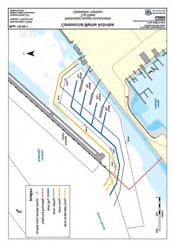
Standard for Commercial Marine Activities – Gladstone Region June 2018
                                 iii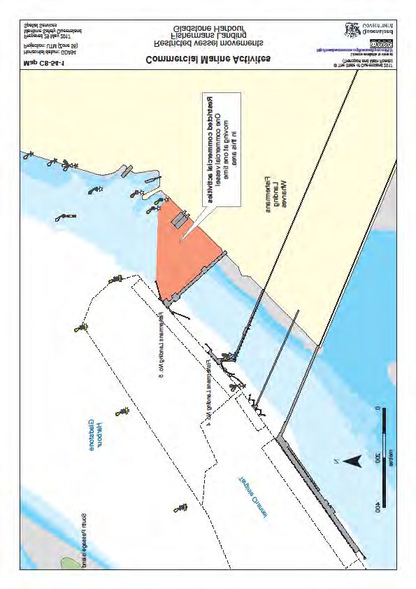
Harbour Master Direction

Direction to master about operation of ship in relation to a pilotage
area, Transport Operations (Marine Safety) Act 1994, section 88.

I, John Fallon, Regional Harbour Master (Gladstone) am appointed as a harbour master under Part
7 of the Transport Operations (Marine Safety) Act 1994.
Under section 86 of the Transport Operations (Marine Safety) Act 1994 a harbour master may give a
direction if the harbour master reasonably considers it necessary to ensure the safety and the
effectiveness and efficiency of the Queensland maritime industry.
Furthermore, section 86A of the Transport Operations (Marine Safety) Act 1994 enable a harbour
master to give a general direction that applies to all ship owners, ship’s masters, ships, other persons
or matters.
To ensure marine safety in the Gladstone region, the Standard for Commercial Marine Activities –
Gladstone Region, has been issued as a general direction

I DIRECT THAT:
The Standard for Commercial Marine Activities – Gladstone Region must be complied with by all
Masters engaged in or associated with projects in the Gladstone Region of Maritime Safety
Queensland, including the Pilotage Areas of Gladstone, Port Alma, Bundaberg and Maryborough.
It is an offence to fail to comply with my Direction without a reasonable excuse. It is also an offence to
obstruct a harbour master in the exercise of a power. The maximum penalty is 200 penalty units for an
individual for each offence. If you fail to comply with my Direction you may be prosecuted, then I may
carry out the Direction myself and recover all expenses associated with performing the Direction from
you as a debt in civil jurisdiction.

John Fallon
Regional Harbour Master (Gladstone)
Maritime Safety Queensland

DATED AT GLADSTONE THIS 25th DAY OF JUNE, 2018

                Standard for Commercial Marine Activities – Gladstone Region June 2018
                                                 iv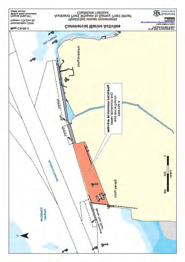
Contents
Creative Commons information                                                             ii
Departmental Version Control                                                             ii

Harbour Master Direction                                                                iv

Contents                                                                                 v

1.       Marine Operations Activity Areas                                                1
1.1      Description                                                                     1
1.2      Application                                                                     1
1.3      Pilotage Areas                                                                  1

1.3.1      Rockhampton Pilotage Area                                                     1

1.3.2      Gladstone Pilotage Area                                                       2

1.3.3      Bundaberg Pilotage Area                                                       2

1.3.4      Maryborough Pilotage Area                                                     2

2.       Port Rules                                                                      4
2.1      General                                                                         4

3.       Vessel Information                                                              5
3.1      Automatic Identification System and Electronic Chart System                     5
3.1.1    Automatic Identification System                                                 5
3.1.2    Electronic Chart System                                                         6
3.2      Vessel Specific Information                                                     6
3.2.1    Barges                                                                          6
3.2.2    Jack-up Barges                                                                  6
3.2.3    Passenger Transfer Vessels (Curtis Island LNG Only)                             7
3.2.4    Tugs                                                                            7

4.       Crew Information                                                                8
4.1      Tug and Unpowered Tow Combinations                                              8
4.2      Barge Masters                                                                   8
4.3      Mates                                                                           8
4.4      Deckhands                                                                       8
4.5      Foreign Certificates                                                            8
4.6      Monthly Safety Forum                                                            8

5.       Operating Procedures                                                           10
5.1      Communication Procedures                                                       10
5.1.1    Port Of Gladstone                                                              10
5.1.2    Ports of Bundaberg & Port Alma                                                 11
5.2      Passenger Number Verification Procedure                                        11
5.3      Evacuation Procedure                                                           12
5.4      Extreme Weather Event Contingency Plan                                         12

               Standard for Commercial Marine Activities – Gladstone Region June 2018
                                                 v
5.5      Marine Incident Reporting                                                     12
5.5.1    General                                                                       12
5.5.2    Vessels Operating Under the Marine Safety (Domestic Commercial Vessels) National
Law Act 2012 or Under the Navigation Act 2012                                          12
5.5.3    Vessels Operating Under the Transport Operations (Marine Safety) Act 1994     13
5.6      Marine Pollution Reporting                                                    13
5.7      Environmental Incidents                                                       13
5.8      Dangerous Goods Transportation                                                14
5.9      Floating Infrastructure                                                       14
5.9.1    Buoy and Pipeline Lighting                                                    14
5.9.2    Buoy Moorings                                                                 14
5.9.3    Manning                                                                       14

6.       Marine Execution Plans                                                        15
6.1      Operational Aspects                                                           15
6.2      Example Marine Execution Plan Content                                         15
6.2.1    Introduction                                                                  15
6.2.2    Adherence to Government Documents                                             15
6.2.3    Operational Plan                                                              15
6.2.4    Vessel Specifications                                                         15
6.2.5    Crew Qualifications                                                           15
6.2.6    Manoeuvring Plan                                                              15
6.2.7    Communications                                                                16
6.2.8    Incident Reporting                                                            16
6.2.9    Evacuation Procedure                                                          16
6.2.10   Extreme Weather Contingency Procedure                                         16
6.2.11   Emergency Contacts                                                            16

7.       Commercial Traffic Rules (Gladstone)                                          17
7.1      Introduction                                                                  17
7.2      Rules                                                                         17
7.2.1    On-water Rules                                                                17
7.2.2    On-board Rules                                                                19

8.      Procedure for Issuing Pilotage Exemption Certificates             (Gladstone
Region Ports)                                                                          20
8.1      Introduction                                                                  20
8.2      PEC Procedure                                                                 21
8.3      Auditing                                                                      21

9.       Appendix – Chartlets                                                          23

              Standard for Commercial Marine Activities – Gladstone Region June 2018
                                               vi
1. Marine Operations Activity Areas
1.1 Description
The standards and associated guidelines that are described herein are specifically formulated for the
Gladstone region, and particularly the Pilotage Areas of Gladstone, Port Alma, Bundaberg and
Maryborough.
The Gladstone Region includes 1868km of mainland coastline from St Lawrence to Double Island Point.
For the purposes of this document, piloted ship movements shall be called ‘trade ships” and any tugs
engaged in the movement of trade ships shall be referred to as “harbour tugs”.
Trade ships, harbour tugs, fishing vessels and lines launches are not considered commercial vessels
for the purposes of this document, however all vessels greater than ten metres operating in the Port of
Gladstone are required to advise Gladstone VTS of their intentions via VHF 13 or 16.
It should be noted that the standards herein do not exempt or excuse operators from conforming to the
appropriate legislation for their specific operations.
1.2 Application
This standard applies to the Masters and all vessels undertaking passenger or local cargo transfer to
Curtis Island within the Port of Gladstone, vessels undertaking marine works (including but not limited
to installation/removal of navigation aids, construction works, pile driving/removal/works, dredging and
wharf maintenance) and any works which fall outside of normal day to day activities.
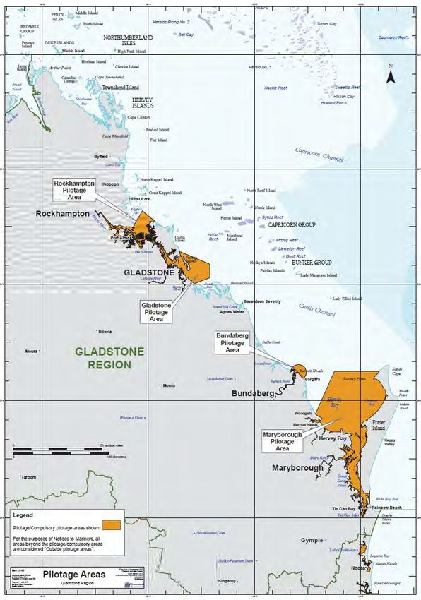
1.3 Pilotage Areas
The Pilotage Areas of the Gladstone Region are defined as:
1.3.1 Rockhampton Pilotage Area:
(a) waters at the high water mark consisting of:
• the Fitzroy River and connected waterways systems from the head of navigation to the river
mouth
• waters bounded by an imaginary line drawn from
o the high water mark at the river mouth at Cattle Point on the mainland to Arch Rock
o then to the high water mark on the northern tip of Cape Keppel
o then by the high water mark in a westerly direction along the northern shoreline and in
a southerly direction along the western shoreline of Curtis Island to latitude 23º 38.41'
south
o then due west to the high water mark on the mainland at latitude 23º 38.41' south
o then by the high water mark in a northerly direction along the shoreline of the
mainland returning to the starting point; and
(b) the navigable waters of rivers and creeks flowing, directly or indirectly, into the waters in
paragraph (a).
Standard for Commercial Marine Activities – Gladstone Region June 2018
11.3.2 Gladstone Pilotage Area:
(a) Waters bounded by an imaginary line drawn:
• starting at the high water mark at Connor Bluff, Curtis Island at approximate latitude 23º 42.91'
south, longitude 151º 17.66' east
• then to latitude 23º 49.51' south, longitude 151º 34.66' east
• then to latitude 23º 56.51' south, longitude 151º 34.66' east
• then to the high water mark at the northern tip of Tiber Point on Hummock Hill Island
• then due west to the high water mark on Wild Cattle Island
• then by the high water mark in a northerly direction along the eastern shoreline of Wild Cattle
Island to the northern tip of the island
• then due west to the high water mark on the eastern shoreline of the mainland
• then by the high water mark in a northerly direction along the eastern shoreline of the
mainland to latitude 23º 38.41' south
• then due east to the high water mark of the western shoreline of Curtis Island at latitude 23º
38.41' south
• then by the high water mark in a southerly direction along the western shoreline, in an easterly
direction along the southern shoreline and in a northerly direction along the eastern shoreline
of Curtis Island to the starting point; and
(b) the navigable waters of rivers and creeks flowing, directly or indirectly, into the waters in paragraph
(a).
1.3.3 Bundaberg Pilotage Area:
(a) waters at the high water mark, consisting of:
• the Burnett River and connected waterways systems from the head of navigation to the river
mouth
• the waters within 4nm radius of Burnett Heads Lighthouse and
(b) the navigable waters of rivers and creeks flowing, directly or indirectly, into the waters in
paragraph (a).
1.3.4 Maryborough Pilotage Area:
(a) waters bounded by an imaginary line drawn:
• starting at the high water mark at a point where latitude 25º 06.90' south intersects with the
eastern shoreline of the mainland
• then generally north-easterly along the geodesic to latitude 24º 44.90' south, longitude 152º
45.06' east
• then east along the parallel of latitude 24º 44.90' south to its intersection with the high water
mark on the western shoreline of Fraser Island
• then generally southerly along the high water mark on the western shoreline of Fraser Island,
and then generally northerly along the high water mark on the eastern shoreline of Fraser
Island to the intersection of that high water mark with latitude 25º 46.31' south
• then along the parallel of latitude 25º 46.31' south to its intersection with longitude 153º 05.00'
east
• then south along the meridian of longitude 153º 05.00' to its intersection with the high water
mark on the mainland
• then generally northerly along the high–water mark on the mainland to the starting point; and
(b) the navigable waters of rivers and creeks flowing, directly or indirectly, into the waters in paragraph
(a).
Standard for Commercial Marine Activities – Gladstone Region June 2018
2Standard for Commercial Marine Activities – Gladstone Region June 2018
32. Port Rules
2.1 General
All Masters to which this standard is applicable, operating within the Gladstone, Bundaberg,
Maryborough and Port Alma Pilotage Areas are required to observe the following conditions:
They must be certified for commercial operations to satisfy the requirements of the Australian
Maritime Safety Authority (AMSA).
The Regional Harbour Master (RHM) is to be advised of the acceptance of a vessel for employment
in a Pilotage Area and the vessel’s owner or charterer is to seek approval for the vessel to enter
the port limits prior to its arrival. As a minimum the RHM will require details of the vessel, where it
is to be berthed or moored on arrival and prior to use, until it is approved to work within the region.
All vessels utilised in any marine operations within a Pilotage Area must be suitable for all operating
conditions that may be experienced.
All commercial vessels working within a Pilotage Area shall have a service speed of no less than
five knots against any tide or weather condition.
Vessels are to display flags/day shapes/lights as appropriate to the task being conducted.
Vessels are to have an operating Automatic Identification System (AIS)
All vessels are to contact Gladstone VTS at the start of each journey and communicate their
departure point and destination. Further requirements can be found in Section 5.1 Communication
Procedures.
Vessels are to comply with the requirements of:
o the Transport Operations (Marine Safety) Act 1994 and Transport Operations (Marine Safety)
Regulation 2016, or Marine Safety (Domestic commercial Vessel) National Law Act 2012, or
Navigation Act 2012, whichever applies to the vessel
Transport Operations (Marine Pollution) Act 1995 and Transport Operations (Marine Pollution)
Regulation 2008
International Regulations for the Prevention of Collisions at Sea (Colregs)
Port Procedures and Information for Shipping for the ports of Gladstone, Port Alma, Bundaberg
and Maryborough as appropriate.
In addition to the above, the specific requirements listed in the following sections are also to be observed
for the Gladstone Region.
Standard for Commercial Marine Activities – Gladstone Region June 2018
43. Vessel Information
3.1 Automatic Identification System and
Electronic Chart System
Automatic Identification System (AIS) and Electronic Chart System (ECS) can be utilised to enhance
situational awareness and aid collision avoidance.
The performance and effectiveness of AIS and ECS as aids to masters and vessel traffic service
operators is heavily dependent on the correct configuration and operation of these units.
All requirements listed here are considered to be minimum requirements.
The equipment prescribed in this Standard is to improve situational awareness and collision avoidance
and does not replace navigational equipment mandated by relevant state, national, or international
legislation.
3.1.1 Automatic Identification System
All commercial vessels 10 metres or greater in length (excluding dumb barges) and all passenger
transfer vessels 6 metres or greater in length, involved in commercial activities within a Pilotage Area
and not required to carry a Class A AIS, must have a Class B AIS transceiver 1 installed, configured and
operating in the manner prescribed in this document.
The AIS unit must:
• comply with International Electrotechnical Commission (IEC) standards 2
• be installed, configured and operated so as to transmit and receive AIS data and display received
AIS data on an ECS
• broadcast prescribed static information indicating certain particulars of the vessel including
Maritime Mobile Service Identity (MMSI) 3, name, type of vessel, call sign (if applicable) and
dimensions of vessel.
• broadcast prescribed dynamic information 4 about the vessel’s position and movement
• refresh dynamic information at intervals no greater than every 30 seconds (if the speed over ground
of the vessel is greater than two knots) and no greater than every three minutes (if the speed over
ground of the vessel is equal to or less than two knots)
• be capable of receiving VDL (VHF Data Link) Message 21 – Aids To Navigation Report for reception
of Virtual Aid to Navigation information.
• Masters will be required to demonstrate their ability to use AIS equipment as a situational
awareness tool.
1 Class B AIS transceivers are AIS units that perform not necessarily in full accordance with IMO’s AIS requirements. Class B
units are defined in Recommendation ITU-R M.1371 and test standard IEC 62287.
2 In particular the AIS unit must conform with the following IEC standards as appropriate:
For Class B: IEC 62287-1 Maritime navigation and radio communication equipment and systems – Class B ship-borne equipment
of the Automatic Identification System (AIS) – Part 1: Carrier Sense time division multiple access (CSTMDA) techniques
For Class A: IEC 61993-2 Maritime navigation and radio communication equipment and systems – Automatic Identification
Systems (AIS) – Part 2: Class A shipborne equipment of the universal Automatic Identification Systems (AIS) – Operational and
performance requirements, methods of test and required test results
3
The Australian Maritime Safety Authority (AMSA) allocates and issues MMSI to vessels.
4 Dynamic information to be broadcast includes the vessel’s position (with accuracy indication and integrity status), time (in
UTC), course over ground, speed over ground and true heading (optional).
Standard for Commercial Marine Activities – Gladstone Region June 2018
53.1.2 Electronic Chart System
All commercial vessels 10 metres or greater in length (excluding dumb barges) and all passenger
transfer vessels 6 metres or greater in length, involved in commercial activities must have an ECS,
operating and configured to display prescribed AIS vessel information for the vessel and vessels in the
vicinity, on a single graphic display that complies with the National Standard for Commercial Vessels 5.
3.2 Vessel Specific Information
All vessels must comply with minimum manning levels as per Marine Order 504 (Certificates of
Operation – National Law) 2013, except vessels less than 12 metres, including tender vessels, which
are to have a minimum of two crew.
All vessels towing barges and any other floating plant in a Pilotage Area are required to have sufficient
horsepower to enable them to fully navigate all areas at all states of the flood and ebb tides.
3.2.1 Barges
When any barge is fitted with a crane, pile driver, excavator, or any other equipment that may affect
stability (whether the equipment is being used or not), the barge must be manned by a barge
master, in addition to the supporting tug’s master. The barge master is to hold a minimum of Master
Class 4/ Master3.2.3 Passenger Transfer Vessels (Curtis Island LNG Only)
• Passenger transfer vessels are to display a yellow flashing light. The yellow flashing light is to be
in accordance with the specifications prescribed by Rule 21 of the International Regulations for the
prevention of Collisions at Sea (ColRegs) and must be installed so as to provide 360° arc of
visibility.
Passenger transfer vessels within Port Limits are not to exceed a maximum speed of 25 knots.
The commercial operator is to submit a Passenger Numbers Verification Procedure as part of a
Marine Execution Plan prior to commencing works, including the method of tracking passenger
numbers and identities in the event of marine emergencies.
All passengers travelling on RO-RO vessels are not permitted to travel inside vehicles. All
passengers must be accommodated in the passenger accommodation area only.
3.2.4 Tugs
All tugs new to the Gladstone region must ensure the tow hook/ winch quick release will operate under
all towing conditions, via a load test. This test must be undertaken with an MSQ approved or Class
surveyor and the results of this test provided to the RHM with the vessel’s Marine Execution Plan.
Approval to operate will not be given until the results of this test are provided.
Standard for Commercial Marine Activities – Gladstone Region June 2018
74. Crew Information
4.1 Tug and Unpowered Tow Combinations
• Tug masters require a Certificate of Competence per powered vessel length.
• Tug and unpowered tow combinations are classified as a ‘small ship’ as detailed in section
163(1)(b) of the Transport Operations (Marine Safety) Regulation 2016.
• For combinations of ships over 50 m (total length of ships), in addition to the relevant certificate of
competence and successful completion of specified local knowledge test, masters will require a
Pilotage Exemption Certificate when operating within Compulsory Pilotage Areas; else a Harbour
Pilot will be required for each movement.
4.2 Barge Masters
• Barge masters supervising barges where stability is a concern (to be determined by the RHM) must
hold a minimum qualification of Master Class 4/-MasterThis Safety Forum meets once a month to discuss and evaluate any issues that may have or may well
arise within the region.
Operators within the Gladstone Region are encouraged to attend the forum.
For more information please email:
RHMGladstone@msq.qld.gov.au
Standard for Commercial Marine Activities – Gladstone Region June 2018
95. Operating Procedures
5.1 Communication Procedures
5.1.1 Port Of Gladstone
In order to enhance the safety of vessels within Gladstone harbour, as well as maintain efficient
communications for all port users, communication procedures have been implemented and are to be
adhered to by all vessels operating in the Port of Gladstone.
It is mandatory for ALL commercial craft operating in Gladstone Harbour to establish and maintain radio
communications with Gladstone VTS on VHF Ch15, advising of departure point and intended
destination. Vessels are NOT to commence moving within the pilotage area prior to establishing
communications and advising VTS of the intended movement. Subsequent instructions and advice
received from Gladstone VTS is to be adhered to at all times. (Note: there is no requirement for
commercial vessels to notify Gladstone VTS of their arrival at their destination).
The following table details the radio channels used in the Port of Gladstone and the service each channel
provides. As channels listed are dedicated harbour working channels specific to particular harbour
operations, commercial craft are only to use VHF channel 15 except when being called by trade vessels
on channel 13 or channel 16 in an emergency.
Note: It is mandatory that all commercial craft be able to simultaneously work VHF Ch13 and 15 whilst
maintaining a listening watch on VHF Ch16.
Gladstone Harbour VHF radio channels
Channel Call sign Service
06 User Bunker Operations
08 User (tugs/pilots) Secondary tug (port) operating channel
09 User Standby channel for port working
10 User (VTS, heli, pilot launch) Pilot transfer operations
12 User (tugs/pilots) Primary tug (port) operating channel
13 Gladstone VTS Vessel reporting, vessel traffic management, port
working
14 REEFVTS Vessels transiting Great Barrier Reef
15 User Commercial craft working channel
16 User Emergency and initial calling
82 User Small craft repeater channel
Commercial vessels must utilise UHF radio for communicating between individual operations (for
example, a tug and its barge) and in-house communications.
In order to assist the master with on board decision making, Gladstone VTS will transmit an all ships
broadcast on VHF channel 15 advising when trade vessels are approaching designated waypoints. This
is a general broadcast and there is no requirement to respond via radio. The following examples indicate
a typical radio broadcast and format.
‘All ships this is Gladstone VTS – the vessel ONKA SPIRIT is approaching A1 inbound to Clinton
Coal Facility number 3 using main channels and Clinton Bypass…Gladstone VTS standing by’
‘All ships this is Gladstone VTS – the vessel RTM WAKMATHA is G1 inbound to Fisherman’s
Landing No 1 using main channels…Gladstone VTS standing by’
When approaching waypoints, vessels associated with marine activities need only make advisory
transmissions indicating positions of their vessels and destination. Gladstone VTS will not answer calls
unless identified in the initial call.
Standard for Commercial Marine Activities – Gladstone Region June 2018
10Note: Due to speed and manoeuvrability, there is no requirement for fast ferries, or vessels
proceeding in excess of 15kts, to report when approaching waypoints T1 and T10.
Vessels are to make an ‘All Ships’ call when approaching the following designated reporting points:
Trade Commercial
G1 Buoy (inbound) Yes No
G4 Buoy (outbound) No Yes
A1 Beacon (inbound) Yes No
T1 Beacon (inbound and outbound) No Yes
T10 Buoy (outbound) No Yes
Approaching Auckland Creek (300 m) No Yes
(inbound to Marina)
Marina entrance (250 m inside) (outbound) No Yes
To ensure good understanding of intentions and to maintain sound communications, correct marine
radio etiquette is to be observed at all times including listening for other radio transmissions prior to
transmitting, clarity in transmissions and patience.
Examples of standard radio transmissions are:
‘Gladstone VTS this is Blue Moon – Departing QC3 to Laird Point with 23 POB’
‘Gladstone VTS this is King Stan – departing Marina for GL5’
‘All ships this is Witless Wisdom – Approaching Auckland Creek bound for the marina’
‘All ships this is Old Edition – Approaching T1 outbound to the marina’
5.1.2 Ports of Bundaberg & Port Alma
Commercial vessels operating in Port Alma and Bundaberg ports are to contact Gladstone VTS on
VHF 13 or 16 and advise their intentions.
5.2 Passenger Number Verification Procedure
There must be a passenger number verification procedure carried on board. This procedure should
ensure all persons on board can be accounted for and should include requirements for crew lists and
passenger manifests.
A count of all persons on board shall be made and recorded when a ship is used to transport passengers.
Confirmation of this check must be noted in the ship’s log book/diary (passenger and crew numbers at
the top of each diary page).
Before the ship departs any berth mooring or anchorage, the master must ensure a crew member:
• counts all persons on board
• makes a written record of the count
• verifies the count by signing the written record.
If anyone leaves the ship permanently for alternative transport to shore or another ship, or if an additional
person permanently joins the ship, the master must ensure a crew member:
• counts each person as they leave the ship
• counts each person as they board the ship
• makes a written record of each of the counts
• makes a written record of the number of persons currently on board
• verifies the information recorded by signing the written record.
The owner or master must keep each record made under this procedure for at least one year.
Standard for Commercial Marine Activities – Gladstone Region June 2018
115.3 Evacuation Procedure
Owners/operators shall provide details of their evacuation procedure for all persons involved in
commercial marine activities as part of the Marine Execution Plan (see Section 6), for approval by the
RHM. This evacuation procedure should outline the interaction with port services, facilities or emergency
services.
Information provided must include but is not limited to:
• Evacuation of persons involved in shore based facilities.
• Evacuation of crew and passengers working on all vessels involved in the commercial marine
group.
• Evacuation of persons in the case of an incident causing injury.
5.4 Extreme Weather Event Contingency Plan
Owners/operators shall provide details of their extreme weather event contingency plan for vessels
involved in commercial marine activities as part of the marine execution plan (see Section 6), for
approval by the RHM. These contingency plans should be created with reference to the Extreme
Weather Event Contingency Plan Gladstone Region
5.5 Marine Incident Reporting
5.5.1 General
The requirement to report marine incidents exists under all legislation for commercial vessels. While
definitions of an incident may use different wording, common to all legislation is the requirement for
incidents to be reported for events involving:
a death or serious injury
damage to a ship
damage to a structure caused by a ship
defect or damage to a ship’s equipment
a collision or stranding
a close quarters situation
Additional events are also defined as marine incidents under the legislation described below. Owners
and Masters must be aware of the requirements relating to their vessel.
5.5.2 Vessels Operating Under the Marine Safety (Domestic
Commercial Vessels) National Law Act 2012 or Under the
Navigation Act 2012
A detailed incident report must be submitted to AMSA on Form 19 within 72 hours of the incident
occurring.
Reports are to be submitted by fax: +61 2 6230 6868 or 1800 622 153 or by email:
reports@amsa.gov.au.
Further details of these requirements and relevant forms are available on the AMSA website:
http://amsa.gov.au/vessels/ship-safety/incident-reporting/
Standard for Commercial Marine Activities – Gladstone Region June 2018
125.5.3 Vessels Operating Under the Transport Operations (Marine
Safety) Act 1994
All marine incidents must be reported to a shipping inspector within 48 hours and a written
marine incident report is also to be submitted.
Shipping Inspectors are Marine Officers (located at MSQ regional offices), officers of Queensland Water
Police and Queensland Boating and Fisheries Patrol. The report must be made on the approved Form
F3071. This form can be downloaded from the MSQ website: http://www.msq.qld.gov.au/Safety/Marine-
incidents.aspx
5.6 Marine Pollution Reporting
The Transport Operations (Marine Pollution) Act 1995 is designed to protect Queensland's marine and
coastal environment by minimising deliberate and negligent discharges of ship-sourced pollution.
Discharges of oil, noxious liquid substances, sewage and garbage from ships (MARPOL Annexes I, II,
lV and V) are prohibited in Queensland coastal waters and pilotage areas.
MSQ has the authority to detain any vessel suspected of causing marine pollution and to intervene
where there is imminent danger to the coastline.
Section 67 of the Transport Operations (Marine Pollution) Act requires the master of a ship to report a
discharge or probable discharge without delay to the harbour master.
The report should be made via ‘Gladstone VTS’ (24 hours) on:
VHF radio: 13, 15 or 16 Phone: +61 7 49715 208 Fax: +61 7 4971 5212
Email: VTSGladstone@msq.qld.gov.au
The Marine Unit Coordinator for the Gladstone Ports Corporation can be contacted on:
Phone: +61 7 4976 1333 (24 hours)
The following details should be provided in a report of marine pollution:
date/time of incident
location (latitude, longitude and/or physical site)
report source and contact number
nature, extent and estimated quantity of spill
type of oil or description
spill source and point of discharge from source
identity and position of nearby ships or name of alleged polluter
nature and extent of spill and movement and speed of spill
local weather/tide/sea conditions
whether a sample of the substance spilled has been collected
any additional information that relates to the spill
The VTS centre will complete the necessary form based on the above information and notify the
relevant authorities.
5.7 Environmental Incidents
Incidents with potential to cause or which have caused ‘environmental harm’ (as defined in the
Environmental Protection Act 1994) within the port, including land and facilities under control of the port
authority, must be reported to the authority as soon as reasonably practicable.
Port users, owners, masters and organisations are reminded it is their responsibility to notify the
Department of Environment and Heritage Protection (DEHP) and/or the relevant Regional Council
Standard for Commercial Marine Activities – Gladstone Region June 2018
13where the incident is of the nature that requires notification under the Environmental Protection Act 1994
and environmental protection policies.
5.8 Dangerous Goods Transportation
Chapter 5, Part 4 of the Transport Operations (Marine Safety) Regulation 2016 outlines the duties of
owners and masters of vessels in relation to the carriage of dangerous goods. The Regulation requires
that ships carrying dangerous goods and bulk liquids must comply with the appropriate directions of the
IMDG Code and AS3846 and are to notify the port authority and the RHM of the intent to carry dangerous
cargo in a pilotage area.
A person who is the owner or master of a ship operating on a local marine service must lodge a
Dangerous Cargo Report at least 48 hours prior to the start of the service which is to be accompanied
by a list of dangerous cargo to be carried.
5.9 Floating Infrastructure
5.9.1 Buoy and Pipeline Lighting
All floating pipelines are to be lit with yellow flashing lights set on one metre poles on the pipeline at 100
metre intervals, so it is evident that there is no safe passage between successive lights located on the
pipeline.
Where sinker pipelines pose a hazard to surface navigation they are to be marked by yellow buoys fitted
with yellow flashing lights, with the interval between successive buoys such that the location of the
pipeline is readily apparent to the mariner.
Individual buoys that have been laid in preparation for the deployment of cyclone moorings are to be lit
with yellow flashing lights on a pile at least one metre high with 360 degree visibility and are not to
encroach into the marked navigation channel.
5.9.2 Buoy Moorings
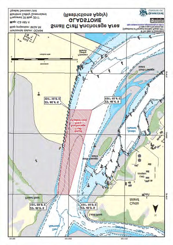
A Category 1 buoy mooring area exists in the western basin of Gladstone Harbour (Chartlet C2-157-1
in Appendix page 23). Enquiries regarding buoy moorings within this area should be directed to
Gladstone Ports Corporation Limited (GPCL).
Information regarding other buoy mooring arrangements can be found at:
http://www.msq.qld.gov.au/Waterways/Buoy-moorings
5.9.3 Manning
The manning requirements for floating infrastructure in the region will be determined by the RHM on a
case by case basis as part of the MEP approval process.
Standard for Commercial Marine Activities – Gladstone Region June 2018
146. Marine Execution Plans
6.1 Operational Aspects
All commercial operators must submit a marine execution plan at least 7 days prior to commencement
of operations.
The purpose of the marine execution plan is:
• to provide an overview for the Gladstone region on the way vessels are intended to be operated
• the nature and scope of operations to be undertaken
• to provide an indication of requirements for local bunkering and waste facilities
• to demonstrate the understanding of the operator of local conditions
• to demonstrate understanding of regulatory requirements for operating in the Gladstone region
• to demonstrate or reference the vessels safety management system and method of handling
emergencies.
6.2 Example Marine Execution Plan Content
6.2.1 Introduction
Brief on type of vessel(s), chartered by whom, and operational purpose.
6.2.2 Adherence to Government Documents
State, federal and international legislation as applicable
6.2.3 Operational Plan
• Intended start date
• Operational activity and duration
• Number of persons involved
• Departure and arrival points
• Public facilities utilised
• Navigation equipment on board as required
• Passenger counting procedure
• Lighting/day shapes/flags
6.2.4 Vessel Specifications
Tugs must include load test results for the tow hook/ winch quick release proving this will operate
under all towing conditions and undertaken with an MSQ approved or Class Surveyor. Certificate of
Operation and Certificate of Survey if applicable are to be included in the MEP.
6.2.5 Crew Qualifications
• Tug and barge combination
• Passenger vessels
• Ropax
6.2.6 Manoeuvring Plan
• General including scheduling
• Tides and prevailing weather conditions
Standard for Commercial Marine Activities – Gladstone Region June 2018
156.2.7 Communications
All operators are to provide details of their means of communication and understanding of
requirements.
• Harbour control communications
• Ship to Shore/ Shore to ship
• Intra-ship communications
As outlined in section 5.1.
6.2.8 Incident Reporting
All operators must provide a plan on internal reporting responsibilities to demonstrate reporting
requirements will be met in the event of an incident as outlined in section 5.5.
• Marine incident
• Marine pollution
6.2.9 Evacuation Procedure
This is to cover the evacuation procedure, any interaction with port services, facilities or emergency
services as outlined in section 5.3.
6.2.10 Extreme Weather Contingency Procedure
All commercial vessels operating in the port are required to have extreme weather contingency
procedures in line with Extreme Weather Event Contingency Plan Gladstone Region.
6.2.11 Emergency Contacts
Operators should include all emergency contacts in their marine execution plan. These contacts must
be readily available to the master on board the vessel.
Standard for Commercial Marine Activities – Gladstone Region June 2018
167. Commercial Traffic Rules (Gladstone)
7.1 Introduction
Nothing in this publication is intended to relieve any vessel, owner, operator, charterer, master, or person
directing the movement of a vessel from the consequences of any failure to comply with any applicable
law or regulation or of any neglect of precaution which may be required by the ordinary practice of
seamanship, or by the special circumstances of the case. In particular the International Regulations for
Preventing Collisions at Sea 1972 (COLREGS) must continue to be obeyed.
7.2 Rules
The philosophy used when developing the rules was for them to be simple, easy to understand, based
primarily on-water and effective in reducing the identified risk in the area.
The rules fall into two broad categories, on water and on board.
The on water rules are in addition to the existing rules found in the Port Procedures and Information for
Shipping Manual for each port, which the relevant vessels must obey.
The on board rules are additional best practices that the master of the vessel is to carry out as part of
safe vessel operations.
7.2.1 On-water Rules
Location Rule
All All departing vessels to contact VTS on VHF 15 before letting lines go
Only one commercial vessel moving at any one time in the area south
Port Central from a line between Barney Point Wharf and Auckland 4 Wharf. See
chartlet C8-55-1 in Appendix page 25
Departing commercial vessels greater than 17m have right of way
Gladstone Marina over inbound commercial vessels. All vessels are to make an ‘All
Ships’ call on VHF15 when exiting and entering.
Behind RG Tanna All arriving vessels (Tugs/Passenger/Ropax) to make “All Ships”
broadcast on VHF 13 before crossing the reporting boundary.
A no wash is to be requested through Gladstone VTS prior to
embarking/disembarking passengers.
Vessels should adhere to the inbound/outbound routes indicated on
the chartlet and aided by virtual navaids within the area. See chartlet
C8-56-1 in Appendix Page 26
Incoming vessels have right of way
Tugs and Ropax not to be passing in the area at the same time. Tugs
have priority and Ropax may follow tugs into or out of the area
“No Wash” to be requested through VTS by passenger vessels when
embarking/disembarking personnel
Passenger and Ropax vessel schedules to be provided to VTS and
Smit Lamnalco
Only one commercial vessel moving at any one time in the area South
Fisherman’s Landing of a line from the Western Dolphin of Fisherman’s Landing No 5 Berth
to the beacon off the Ro/Ro ramp at Fisherman’s landing (FL Y 3sec)
in approximate position Lat 23°47.14’S; Long 151°10.2’E. See
chartlet C8-54-1 in Appendix page 24.
Standard for Commercial Marine Activities – Gladstone Region June 2018
17Narrows Crossing and Laird Point traffic to transit via the mainland
Passage Island Channel side of North Passage Island.
All APLNG vessels from Fisherman’s Landing will transit via the
mainland side of North Passage Island.
APLNG vessels from other locations will preferentially transit via the
mainland side of North Passage Island unless there are navigational
considerations that would make the transit along the Curtis Island side
of North Passage Island safer.
Commercial vessel traffic to keep a minimum clearance of 0.5 nautical
Auckland Inlet miles (nm) from all small sailing vessels undertaking club races.
Commercial passenger and personnel ferries to display yellow
All areas, Including Gladstone, flashing light 6 (Curtis Island Ferries Only)
Bundaberg and Port Alma
Speed limit for ferries is 25 knots within Port limits
All commercial traffic to remain outside of the shipping channel when
a trade ship is in, or approaching, that channel.
In addition to the above rules, it was identified that additional on water rules are required to reduce the
risk of a collision or close quarters situation in the Clinton Channel, Clinton Bypass Channel and the
Clinton Channel Swing basin. Due to the large variables affecting ship interaction in this area it is difficult
to set a simple rule that is safe but fair to all operators. The following is mandated.
Location Rule
Clinton Channel Swing Basin No commercial vessels to be in the Clinton Channel swing basin
when a trade ship is in or entering the swing basin.
Clinton Channels No tug and barge combination operations to be in the Clinton
Channels when a trade ship is due to be in that same area.
The following guidance is provided to assist masters with their decision making.
Location Rule
Clinton General Where safe to do so vessels are to transit outside of the main
Channels shipping channel.
Inbound ship for All tug and barge combination operations west of T2 to stop and
Clinton Coal hold at Hamilton Point until the coal ship has completed swing.
Facility passes A5
All tug and barge combination operations at berth east of Clinton
Coal Facility to remain at berth until the coal ship has completed
swing.
Outbound ship All tug and barge combination operations west of T2 to stop and
from Clinton Coal hold at T2 until the coal ship has passed A7.
Facility
All LNG tug and barge combination operations at berth east of
Clinton Coal Facility to remain at berth until the coal ship has
passed.
Inbound ship for All LNG tug and barge combination operations west of T2 to stop
Fisherman’s and hold at Hamilton Point until the trade ship has passed.
6
The yellow flashing light is to be in accordance with the specifications prescribed by Rule 21 of the International Regulations
for the prevention of Collisions at Sea and must:
(a) Satisfy the colour and intensity specifications of Sections 7 and 8 of Annex 1;
(b) Be installed so as to provide 360° arc of visibility;
(c) Only be displayed when the vessel is underway.
Standard for Commercial Marine Activities – Gladstone Region June 2018
18Landing passes All LNG tug and barge combination operations at berth east of
A5 Clinton Coal Facility to remain at berth until the trade ship has
passed.
Outbound ship All tug and barge combination operations west of T2 to stop and
from Fisherman’s hold at Hamilton Point until the trade ship has passed
Landing passes
All tug and barge combination operations at berth east of Clinton
T10 Coal Facility to remain at berth until the trade ship has passed.
7.2.2 On-board Rules
Location Rule
At berths All departing vessels to use all available means including the AIS
display to check for potential traffic conflicts before letting lines go.
If in doubt that there is enough time to make a safe transit before a
trade ship requires a clear channel then the vessel is not to leave
the berth
Gladstone Marina All inbound vessels to check AIS display for potential traffic conflicts
coming out of the marina before they commit to entering Auckland
Inlet.
All areas All vessels to use all available means including the AIS display to
check for potential traffic conflicts during transits.
Bright deck lights on commercial vessels to be shielded to sea.
Non-essential deck lights on commercial craft to be turned off when
underway.
All commercial craft to use bypass channels as preferred routes.
Do not communicate on the VHF radio channels used for tug
communication – channels 8 and 12.
Vessels are only to display warning flags/shapes when operations
require them and to remove them when not necessary.
All swing basins Do not call up the ship/pilot on VHF radio when a ship is swinging –
they are busy concentrating on the manoeuvre.
Standard for Commercial Marine Activities – Gladstone Region June 2018
198. Procedure for Issuing Pilotage
Exemption Certificates
(Gladstone Region Ports)
8.1 Introduction
All ships or combination of ships that are 50 metres or more operating within a Queensland compulsory
pilotage area must either carry a licensed marine pilot or be under the command of a master who holds
a Pilotage Exemption Certificate (PEC) for the ship or an area endorsement for the relevant pilotage
area.
Maritime Safety Queensland (MSQ) may grant a PEC within a Queensland compulsory pilotage area.
A PEC will only be issued for Australian registered ships.
Port operational requirements mean it may not always be feasible to engage the services of a certified
marine pilot. For this reason, companies are encouraged to identify a senior training master who,
subject to the RHM Gladstone’s approval, will act as the ‘exempt master’ supervising the navigation of
applicants.
Senior training masters must be appropriately licensed and hold a current pilotage exemption.
The senior training master will only be permitted to supervise the navigation of applicants on vessels
declared suitable by the RHM (Gladstone).
The senior training master will not be permitted to set or assess practical examinations for the applicant.
Senior training masters will satisfy the requirements of the Transport Operations (Marine Safety)
Regulation 2016 by having the conduct of the vessel until the master has obtained the requisite pilotage
exemption.
The master applying for an exemption may be an employee or contractor of the ship owner. First mates
that hold a valid masters ticket for the vessel they are operating are also eligible to apply for a PEC.
The senior training master will:
• have pilotage conduct of commercial vessels in the Gladstone region to meet the regulatory
requirements of the Transport Operations (Marine Safety) Act 1994
• provide the opportunity for masters to gain and demonstrate the practical ship handling skills and
local knowledge expertise to obtain a Pilotage Exemption Certificate for ports in the Gladstone
region
• provide advice to the RHM (Gladstone) about the Pilotage Exemption Certificate applicants’
competence in ship handling and local knowledge to support the RHM decision for pilotage
exemption
• not be permitted to have conduct of the marine commercial vessel unless the master of the vessel
is gaining local knowledge expertise and demonstrating practical ship handling competence for the
purpose of obtaining a Pilotage Exemption Certificate
• have the skills and experience to train, mentor and assess in the areas of:
• local knowledge of the port of operation
• ship handling skills of vessels for which the exemption will be sought.
The senior training master must:
• act reasonably and fairly;
• exercise professional skill and judgment in the conduct of marine vessels in the Gladstone region
ports;
Standard for Commercial Marine Activities – Gladstone Region June 2018
20• provide prompt and accurate advice to pilotage exemption applicants and MSQ;
Senior training masters are not agents, employees or sub-contractors of MSQ.
Theoretical testing of all applicants will be undertaken by the RHM (Gladstone).
Decisions about the issue of Pilotage Exemption Certificates will be made solely by the RHM (Gladstone
region) and will be made in accordance with the Transport Operations (Marine Safety) Act 1994.
8.2 PEC Procedure
Applicants for a Pilotage Exemption Certificate to operate marine commercial vessels in the Gladstone
region ports are required to:
• Undertake local knowledge training on water for 40 hours, including 16 hours at night (20 hours
[including eight hours at night] of which must be on vessels that the master is to command).
• Successfully complete a local knowledge exam and receive a local knowledge qualification.
• If a master, having already completed the local knowledge exam, has not operated a
vessel in the region for a period greater than two years, they will be required to
complete the examination component again.
• Successfully complete mentor trips (minimum of six trips on passage and vessel for which
exemption is sought; in and out = one trip). Mentor trips must be undertaken under the supervision
of a marine pilot or senior training master approved in writing by the RHM.
• Successfully complete MSQ issued written exam, including chart.
• Successfully complete check pilot assessment with a senior marine pilot.
• Apply to MSQ for pilotage exemption by submitting the following:
• application for marine pilotage qualification
• current medical
• original qualifications
• letter from company
• copy of local knowledge qualification
• passport photos
• fees and completed check pilot assessment
• letter of recommendation from senior master
• Obtain an MSQ issued temporary authority to enable applicant to complete supervised mentor
trips.
On completion of mentor trips and submission of all documents, the RHM will issue a PEC
The decision whether to issue a Pilotage Exemption Certificate, and if any conditions are imposed, will
be made by the RHM (Gladstone).
Exemptions are valid for a period of two years and are subject to a minimum number of voyages
specified by the RHM being undertaken in that period.
8.3 Auditing
Holders of Pilotage Exemption Certificates granted by MSQ will be subject to audits conducted by
MSQ personnel.
These audits may include verification of records of service and Check Pilot observational assessments
conducted during routine movements to verify the holders’ practical ship handling ability and local
knowledge. A Check Pilot refers to a person who is licensed under a regulation as a pilot and who is
authorised by the RHM to assess an applicant’s competence.
Standard for Commercial Marine Activities – Gladstone Region June 2018
21MSQ officers or delegate will also perform ‘Check Pilot’ audits including on board observation,
supervisor trips, and practical examination trips to verify the performance of PEC holders.
Standard for Commercial Marine Activities – Gladstone Region June 2018
229. Appendix – Chartlets
Standard for Commercial Marine Activities – Gladstone Region June 2018
23Standard for Commercial Marine Activities – Gladstone Region June 2018
24Standard for Commercial Marine Activities – Gladstone Region June 2018
25Standard for Commercial Marine Activities – Gladstone Region June 2018
26You can also read