Study of Beach State and Coast Protection within Sochi City
←
→
Page content transcription
If your browser does not render page correctly, please read the page content below
Study of Beach State and Coast Protection within Sochi City

           R.Kosýan1, M.Krylenko1, V.Petrov2, N.Yaroslavtsev2
1
  The Southern Branch of the P.P.Shirshov Institute of Oceanology, Russian Academy
of Sciences. Gelendzhik-7, 353467, Russia.
 E-mail: kosyan@sdios.coast.ru
2
  Centre “Sea shores”, 1,Fabritsiusa str., Sochi, 354002 Russia

Abstract

        In 2004 the research of the gravel beach condition and that of the coast protection erections
were fulfilled at the coast section of Sochi region. In the coarse of expeditionary works
measurements, surveys and estimation of the coast state and coast protection objects have been
done. Besides, fund material belonging to the Southern Branch of the P.P. Institute of Oceanology,
RAS and those of the other institutions were used.
        Main factors that determine the dynamics of wave damping beaches were distinguished and
the efficiency of beach holding and coast protection constructions was determined. It was revealed
that a degradation of natural gravel beaches takes place and coast protection constructions are not of
much efficiency. An expediency of keeping of the wave damping beach stability by the help of
gravel-pebble ripraps with the limited utilization of the other methods of beach preservation was
founded.
        The results of the research may be a basis for the coast protection strategy and elaboration of
definite engineering measures.

Introduction

        The Black Sea coastal zone contains the richest natural resources and is an object of
intensive economical activity. Coastal region is densely populated. Within it there is huge industrial
and civil building, and a recreation load is rather essential. At the same time coasts are very
vulnerable, and study of their changeability and coast protection is necessary.

      Coast section between Magri and Adler is one of the most peculiar parts of the Black Sea
dynamical system. It should be noted, that thanks to its natural peculiarities, sedimentary flow at this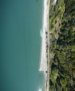
coast section is directed from the north-west to south-east. This circumstance is very important from
the point of protection and restoration of the lost gravel beaches.

        The presence of the railway which was built along the seashore in 1914 is a characteristic
feature of a given coast section. When performing coast protection measures, the main attention
must be paid to the protection of railway bed from wrecking influence of the sea. It was planned to
implement the beach restoring and keeping with the help of beach protection constructions – groins
and breakwaters. It was proposed that beach growing would be realised due to natural coastal
processes, by means of sediment interception and conservation, and at the coast sections where
amount of shifting material is not sufficient – by ripraps of imported beach forming stock. An
intensive building of groins and breakwaters continued till the middle of 80-ies. Exhaustion of
natural sedimentary flows and low rates of ripraps of imported material resulted in the fact that at
some sections the beach broadness turned to be insufficient for the damping of storm waves, and at
the other sections the beach completely disappeared.

        The goal of performed research is to distinguish main factors, which determine the dynamics
of wave damping beaches and efficiency of beach holding and coast protection constructions. And
creation of the basis for elaboration of coast protection measures when projecting recreative
complexes with regard for the modern processes in the coastal zone at the section under
consideration.

        Several tasks were solved when realizing the project. The first one is to collect a
representative massive of data on the coast state and that of their changeability during the
instrumental observations for coastal processes and the coast protection performing. The second – to
carry out modern inspection of the coast state and coast protection condition. The third – to fulfill a
comparative analysis of modern and future processes of coastal zone evolution. This task exceeds
the limits of the present project, but it begins within it.

        Investigating coast was divided into eight sections according to morphological features of
the coast and lithodynamic processes taking place within it. Boundaries of the sections coincide
with the river mouths. Characteristics of the beach belt and coast protection constructions are given
for the every coast section.

Brief characteristics of the coast section between Magri and Adler settlements

        Considered coast section, 105 km long, is in Sochi region. According to its geological
conditions this section may be divided into four regions. The northern region between rivers
Tuapse and Shakhe is composed of terrigenous-carbonate flysch of the Upper Cretaceous.
Region between rivers Shakhe and Psakhe is presented by terrigenous sub-flysch of Paleogene.
The section to the south of Psakhe river up to Kudepsta river is composed of molasses formation
of the Upper Paleogene. Southward Imeretinskaya lowland is situated, which is the delta
projection of Mzymta and Psou rivers. Recent marine deposits are presented by beach fine
boulder-gravel-pebble sediments with sandy-aleuritic filler, and by sandy-aleuritic deposits of
the continental slope down the depth of 20 m.

        Slope deposits of different genesis are rather widely presented, but abrasion rocky shelves
prevail. Landslip deluvial and play the main part near the margin of the coastal zone. Today an
interaction of these processes with abrasion ones is interrupted due to intensive reinforcing of the
slope and coast along the railway. Fulfilled observations show that the erosion of loose deposits
during cloudburst floods reaches 2 m/h, and that results in the formation of erosion grooves,
development of caving-crumbling processes, and appearance of landslips and falls. To the
south of the Shakhe river valley landslip and falling processes are wide-spread the most
dangerous.
In the presence of storms and cutting out of the beach width abrasion influence of surf
flow becomes greatly important for the rates of coast evolution. Erosion and slope processes are
greatly developed on the steep slopes of the abrasion shelf, and submerged slope within the
Imeretinskaya lowland. The width of the beach at the given coast section varies from 0 to 60 m,
and a mean width – 19,4 m. Along the length of 41 km beach broadness is less than 15 m, i.e.
less than minimum value necessary for wave damping. Here and there the beach is washed-out
completely. Average dimensions of beach strip were decreasing during a long time. Beginning
from 1973, a tendency of the beach growing has taken shape, by 1982 its width has become 13
meters, but then it began to decrease again (Table 1). Beach growing during the period from
1973 to 1983 was connected with the ripraps of material obtained from the hill-sides cutting in
front of baffle plate and partially by the increase of river solid run-off.
Table 1: Average broadness of beach (m)
Locations Length, km 1956 1977 1999 2004
Magri - Ashe 12,0 9,3 8,3 12,0 11,8
Ashe – Psezuapse 8,9 23,7 15,5 15,2 15,1
Psezuapse – Shakhe 16,5 21,7 23,6 22,4 22,3
Shakhe – Sochi 31,9 23,6 24,2 21,8 21,6
Sochi – Bzugu 4,3 - - - 12,8
Bzugu – Кudepsta 13,6 11,9 12,9 16,2 16,5
Кudepsta– Mzymta 9,0 19,0 22,8 17,3 17,1
Mzymta – Psou 8,01 - - - 40,0
In natural conditions river solid run-off guaranteed stability of the beach belt owing to
material carrying out and its further shift along the shore under the influence of waves.
Investigations have shown that removal of beach material from the river beds and beaches,
which is continuing until today becomes the principal reason of the beach degradation at a given
coast section. Excavation of alluvium from rivers has resulted in changing of river channel
slopes, and this has affected the amount of solid run-off. Modern run-off of beach forming
sediments at the coast section between settlement Magri and river Mzymta (excluding the latter)
is about 103 thousand cubic meters in year.
During the latest 10 years annual volume of rip-raps of beach forming material, that is
performed by different institutions, roughly is 90 thousand cubic meters in year. Supply of
beach material from along shore flow to the beach section may be estimated as being 3
thousand cubic meters in year. Beach volume reduction due to sediment attrition, which is 216
thousand cubic meters in year, is the main part of losses. Withdrawal of sediments of long shore
flow out of the considered coast section is not more than 1 thousand cubic meters in year. The
rest debit items of the beach material balance may be neglected. Thus, sediment balance at a
given coast section is negative, and that results in continuing degradation of beaches.
Below a characteristic of a modern state of beach belt and coast protection constructions
is given for a certain coast sections, borders of which are mainly coincided with the river
mouths. The length of the coast section between the settlement Magri and the mouth of Ashe
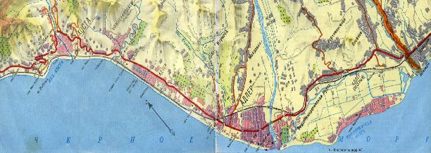
river is 12 km (Fig. 1).OYE
A she
SK
HE
V
ARE
E
Z
AS
PS
LA
S h e ps
i
KO
eps
i
MA
g ri
Sh
Ma
B L A C K S E A
Fig. 1: Coastline between Magri and Lazarevskoye
The coast is abrasion one along the whole length. Protection of the earthen bed of the
railway and that of adjacent area from erosion by storm waves implemented by means of
revetment-baffle plate and system of groins. In recent years its reinforcing was fulfilled. At some
coast sections a new revetment-baffle plate has been built, it is displaced for 4-10 m off shore.
Today a general length of baffle plates consists 84,2% from the whole length of the section, there
are 33 groins of different design, time of building and extent of safe keeping, which can cover
about 1.6 km of the coast. Besides mentioned constructions two fragments of wave damping
berms have been built of tetrapods, each being 150 m long. The results of the beach broadness
measuring are presented in Table 2.
Table 2: Coast length with different broadness of beach
Beach broadness, m
Value >25 25-15 15-5 5-1 25 25-15 15-5 5-1Coast section between mouths of Psezuapse and Shakhe rivers (Fig. 2), 16.5 km long,
stretches to the south from an accumulative projection which is formed of run-off of Psezuapse
river. The coastline is presented by variety of small bays with a slight cutting into the land.
HE
AK
e
g
SH
d
P S EZ UA P SE
va
ok
it
m
he
ka
C
in
ov
ol
G
B L A C K S E A
Fig. 2: Coastline between Lazarevskoye and Shakhe
This coast section is characterized by free beaches without protection constructions.
Beaches are replenished with sediments owing to watercourse and bottom erosion. Almost along
the whole length the coast is protected by baffle plate. To estimate the change of the beach
broadness at this coast section data of repeated measurements, including those obtained in the
course of the present project, were used. A mean broadness of beach has reduced for 1.3 m and
its reduction occurred due to the baffle plate moving by sea. During the latest twenty years an
average broadness of the beach changed slightly at this coast section. Table 4 shows the data on
the coast section length with different beach broadness.
Table 4: Coast length with different broadness of beach
Value Beach broadness, m
>25 25-15 15-5 5-1At the coast section between Shakhe and Sochi rivers (Fig. 3, 4) 7,3 km are without baffle
plates. These are sections where railway track is far from the water edge. In different years 111
groins, 11 submerged and 4 intermittent breakwaters were built in this region. Total length of
intermittent breakwaters is more than 16 km. At short coast sections wave damping berms were
built of large boulders and concrete blocks. In recent years the volume of imported material rip-
raps for creation of wave damping beaches increased.
hel
L oo
Sc
o
D
ay a
Lo
s
my
o rn
Ya k
go
Da
B L A C K S E A
Fig. 3: Coastline between Shakhe and Dagomys
A gura
P s
s
my
ak
Bz
h e
M
ug
go
at
es s
u
ta
Da
I
CH
Da
SO
go
my
SOC
s
H I
B L A C K
I
S E A
CH
SO
Fig. 4: Coastline between Dagomys and Khosta
A general notion about the beach state and its dynamics within the whole section was
obtained on temporal changes of a mean broadness of a beach belt. During 26 years the beach
width decreased for 2.5 m, this was caused by intensive withdrawal of pebbles from Shakhe
river bed and water-meadow. Reduction of pebble carrying out by the river into the beach zone
was not compensated by rip-raps of beach material to local coast sections, though they grew in
the recent years. Maximum erosion and reduction of the beach width took place in the northern
part of this coast section. Here and there the beach width reduced for 25-30 m, and in some
places the beach was eroded completely. Today on the length of 11.3 km the beach width is less
than 15 m, baffle plates, 25 km long, have no beach in front of them or its width is less than 5 m.
At the 3-km long coast section southward from the mouth of Shakhe river intermittent
breakwater of concrete massifs was built to prevent erosion. This resulted in broadening of beach
behind breakwater and on the adjacent upper coast section to 15-25 m ( the length is 300 m). At
the same time the beach about one km long at the low coast section was washed out almost
completely. And this demanded urgent emergency-rescue measures. In four places stone and
gravel rip-raps were being done for three years.Fig. 5: Beach broadness at the closely-spaced coast sections
Coast section between rivers Sochi and Bzugu (Fig. 4), 3.6 km long, is one of the most
rich in coast protection and beach holding constructions. There the sea port of Sochi is situated.
Baffle plate is built along the whole coast section, it protects municipal and sanatorium
embankments from erosion. In different years 52 groins and breakwaters,2.2 km long, were
built. Majority of mentioned erections is in a satisfactory condition.
During the latest 10 years reduction of the beach broadness took place, due to the absence
of a natural along shore sedimentary flow and that of rip-raps, which can replenish a beach
volume. Today the broadness of the beach in certain areas between groins is 6-18 v, and an
average one for the whole section – 12.8 m. Appropriate data are adduced in Table 5.
Table 5: Coast length with different broadness of beach
Value Beach broadness, m
>25 25-15 15-5 5-1(Table 6). Natural replenishment of beaches due to carrying material from Matsesta, Agura,
Khosta rivers and owing to the bottom erosion is not considerable. Material carrying out by
Matsesta river even cannot guarantee a stability of the beach which is situated to the south from
the mouth of the river.
Table 6: Coast length with different broadness of beach
Value Beach broadness, m
>25 25-15 15-5 5-1 25 25-15 15-5 5-1At this section a balance has periodically happened between the supply of material due to solid
run-off and its losses (mainly along the talwegs of submerged canyons and as submerged
landslips) to the continental basement. Then fans and such deposits like turbidities are formed.
Continental slope begins almost from the beach foot and is a transit zone.
ta
TA
K ho
ps
OS
de
sta
Ku
s ta
KH
dep
Ku
R
PS
LE
TA
OU
AD
M ZYM
R
LE
AD
B L A C K S E A
Fig. 6: Coast section between Khosta and Psou rivers
In the phase of the storm development sediments being drawn to the surf zone get on the
steep slopes and sink down the depth which exclude their coming back. As a result, the loss of
material is large.
Within the 8 km long section there are four zones of sediment sinking to the depth –
opposite the Mzymta river mouth at the near mouth spits, in front of Novy canyon,
Konstantinovsky cape, Psou cape. A long evolution of these forms is of a pulsation nature. Cape
position does not change essentially. A considerable change of wave regime is necessary for a
radical reconstruction. Values of pulsations are 100-120 m. Beaches of the region were the
sources of quarry material for along time. After the cessation of material withdrawal the coastal
line began to restore slowly, but owing to a sharp decrease of solid run-off of Mzymta (caused
by withdrawal of bed alluvium) a full restoration is hardly possible. Today an average broadness
of the beach at this section is 40 m.
Conclusions
The analysis of the material on the state of the coastal line between settlement Magri and
Psou river has shown that a steady reduction of the width of natural gravel beaches takes place.
Works directed to the beach stabilization and replenishment by imported material lower rates of
degradation. But they are not capable to stable or broaden the beach belt at the whole section.
Recreation complexes with broad beaches are built only on local places of the coast. There are
kept only several fragments of natural gravel beaches within the mentioned coast section: near
the settlements Lazarevskoye, Loo and southward from the mouth of Mzymta river.
It should be noted that such an index as an average width of the beach is not sufficient for
the whole section. A beach of necessary broadness (not less than 15 m) must be at every coast
section, in this case its wave damping efficiency and recreation value is highly enough. When the
beach broadness is less a direct storm impact on the baffle plates and on the shore is possible,
and a danger of their destruction or erosion is great.During the latest years the intensity of technogenous impact on the nearshore zone and on
the object feeding it is essentially increased. Solid run-off of large rivers is reduced, sedimentary
flow is interrupted by a system of groins and breakwaters, which practically intercept all gravel-
pebble material migrating along the shore. In such a situation a restoring of a beach belt by a
natural way is impossible.
Results of the work must be the basis for creation of strategy of coast protection and for
elaboration of definite engineering measures.
References
Kos’yan R.D., Magoon O.T. (1993), "Coastlines of the Black Sea", Publ. by ASCE, New York.
Kos’yan R.D., Magoon O.T., Yesin N.V. (1999), "The modem exploitation of the Russian Black
Sea coast", Proc. of the Fifth International Conference on Coastal and Port Engineering
in Developing Countries, Cape Town, South Africa.
Kos’yan R.D., Podymov I.S., Pykhov N.V. (2003), "Dynamic processes of the seacoast zone",
Moscow, 325 p.
Kos’yan R.D., Pykhov N.V., Edge B. (2000), "Coastal Processes in Tideless Seas", Publ. by
ASCE, New York.
Kos’yan R.D., Yesin N.V. (1994), "About environmental management of coast zone",
Oceanology, Т. 34, № 4.
Kos’yan R.D., Yesin N.V. (1996), "An anthropogenic impact upon the Black Sea coast of
Russia", Proc. of the International Conference "Coastal Change'95", Bordo, France.
Kos’yan R.D., Yesin N.V. (1998), "Fight against erosion of the Caucasian black sea coast",
California and the World Ocean, V.1,Virginia, Publ.By ASCE, USA.
Kos’yan R.D., Yesin N.V., Peshkov V.M. (1997), "Erosion of the Caucasian Black Sea coast",
Proc. of the International Conference "BORDOMER'97", Bordo, France.
"Results of nature investigations and modelling of Black sea coast processes in Krasnodar
region" (1984), Report ЧО ЦНИИС. Мoscow.You can also read