Summary of 2018-19 Tasmanian fire season - Tasmanian National ...
←
→
Page content transcription
If your browser does not render page correctly, please read the page content below
Summary of 2018-19 Tasmanian fire season
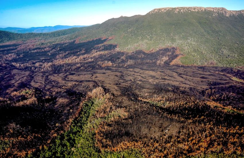
Aerial view of burnt ridges above Huon River, Arthur Range beyond, Tasmanian Wilderness World Heritage Area.
Photo: Grant Dixon
It would be difficult for anyone in Tasmania to have escaped knowledge of the extensive bushfires that have
burnt throughout Tasmania during the past summer. Fires burnt for more than five weeks throughout a
record-breaking dry January. The situation eased somewhat with a week of westerly rain and showers from
8th Feb, although fires remained active in a number of areas, with many hot spots. This was written on 2nd
March, another day of high fire danger, so there perhaps remains scope for further expansion of the active
fires for a few more weeks yet.
Most of the Southwest National Park and the southern part of the Franklin-Gordon Wild Rivers National Park
were closed to public access for much of the summer, and parts remain so until the impact on infrastructure
and access can be assessed.
We previously descibed the evolving fire situation in late January. This document reflects on the current
situation as the fire season (hopefully) ends.
Some quotes of the 2018-19 fire season
10th January, Mercury newspaper
In a letter to Emergency Service Minister Michael Ferguson, on 8th January, the United Firefighters Union
(UFU) noted they had proposed a trial of an initial fire attack response prior to the current fire season. Vice-
1
president Leigh Hills also supported calls for a summit to discuss a range of issues, noting, “we’re not as
prepared as what we could be, and initial attack is a basic example of that, to be able to get on top of a fire
earlier”.
Greens Senator Nick McKim observed that, “the UFU proposal was comprehensive and cost-neutral, and it
beggars belief it was not accepted at least for a trial.”
Minister for Emergency Services Michael Ferguson deflected any criticism by referring to “armchair critics”
and commenting that “we see this opportunism from the Greens each fire season …”

31st January, Mercury newspaper
In the light of what was referred to as a potential “environmental catastrophe” (ABC) and calls by Nature
Photographers Tasmania and the Wilderness Society Tasmania (30th January) for an “urgent request (for)
international amphibious water-bombing assistance to combat the unfolding tragedy at some of the world’s
most important and iconic natural sites, in the Tasmanian Wilderness World Heritage Area”, the following
comments made it clear where priorities lie:
PWS General Manager Jason Jacobi noted his agency’s request for large aircraft to drop retardant in
threatened areas had “(proven) to be a challenge” because resources were so stretched.
But Tasmania Fire Service Chief Officer Chris Arnol stated “there was no need to request resources outside
Tasmania”.

1st February, Mercury newspaper
PWS spokesperson Ashley Rushton claimed success at protecting wilderness values; “we have been doing
natural value asset protections that have been very, very successful”. At the time, approximately 180,000 ha
and counting had been burnt, about half within the Tasmanian Wilderness World Heritage Area (TWWHA).

The extent of areas burnt by the 2018-19 wildfires and impact on natural values
According to the Tasmanian Fire Service (TFS) mapping, the total burnt area is some 205,000 ha, illustrated
by this map. This comprises 3.2% of the state's total mainland area. Almost half of this (about 93,000 ha) is
within the TWWHA. This comprises 5.9% of the TWWHA. (And remember that 45,000 ha also burnt in 2013,
and then there were the 2016 fires, so about 10% of the TWWHA has been burnt in 6 years.)
Here is a first attempt at analysing what has been burnt, by the University of Tasmania’s Fire Centre
Research Hub. The bland statistics downplay the real-world impact; they note that "only 3.2%" of the area
burnt is rainforest but this is still some 6000 ha that will likely take many centuries to recover. And alpine
country is not distinguished in the vegetation community classification used but is known to have been burnt
in some areas (Crest Range, Denison Range, Central Plateau) and possibly others (Schnells Ridge, Eastern and
Western Arthurs); see below. And there is inevitable heterogeneity even within areas mapped as vegetation
communities “resilient to fire”, with the landscape including copses and corridors of more sensitive
vegetation. Furthermore, some areas were also burnt in the 2007 wildfires so incremental loss of organic soil
(peat) in these areas, and on better-drained slopes, is likely.
On the basis of our own analysis, using TFS and other public data, the vegetation considered “extreme” or
“very high” fire sensitivity1 comprises just over 3% of the total statewide burned area. This doesn’t sound like
much but is potentially pretty significant given the large total area burnt. The following maps illustrate the

1
  Tasmanian vegetation communities have been classified based on flammability, and fire sensitivity (see Table 1 here).
Extreme fire sensitivity includes King Billy, Pencil Pine, Morrisby's Gum, Spinning Gum, Huon Pine, Fagus, and silviculture
plantations. Very High fire sensitivity includes quite a few more mixed vegetation types (see Table 1 in the publication
linked above for exactly what these are). They include various alpine heathland and moorland communities, alpine
rainforest and woodland, and wet Eucalypt forest types.

                                                             2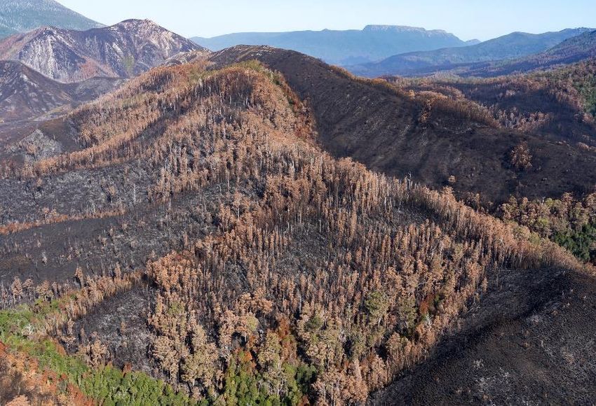
area burnt in the Denison Range - Vale of Rasselas and Huon - Cracroft valley areas, just two of the 2018-19
fire grounds largely within the TWWHA. Within these areas the fires have obviously burned with varying
intensities so the extent of short and long term damage remains uncertain.

Gell River (Denison Range – Vale of Rasselas) fire showing burnt vegetation types, EXTREME fire sensitivity
vegetation in red, VERY HIGH fire sensitivity in turquoise.

Riveaux Road (Huon –Cracroft valley) fire showing burnt vegetation types, EXTREME fire sensitivity in red,
VERY HIGH fire sensitivity in turquoise, silviculture plantations (listed as EXTREME fire sensitivity) highlighted
in yellow.

                                                         3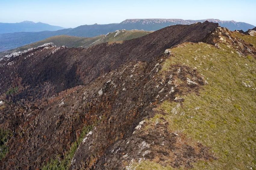
Commentary by PWS and others has often seemed to downplay the potential or actual impacts of the fires
on natural values. Reporting of the natural values at risk has been largely down to groups like ourselves,
Nature Photographers Tasmania and the Wilderness Society Tasmania; for example, see here and here.

A picture can tell a 1000 words …
The above maps and statistics provide a somewhat abstract representation of the areas burnt whereas
photographic imagery can bring home what is really at stake. The following aerial images, and the
introductory one above, were captured on 23rd February 2019.

            Burnt tongues on the slopes of Mt Bobs, above the South Cracroft Valley. Photo: Rob Blakers

                  Burnt rainforest at the forest edge on the slopes of Mt Bobs. Photo: Grant Dixon

                                                         4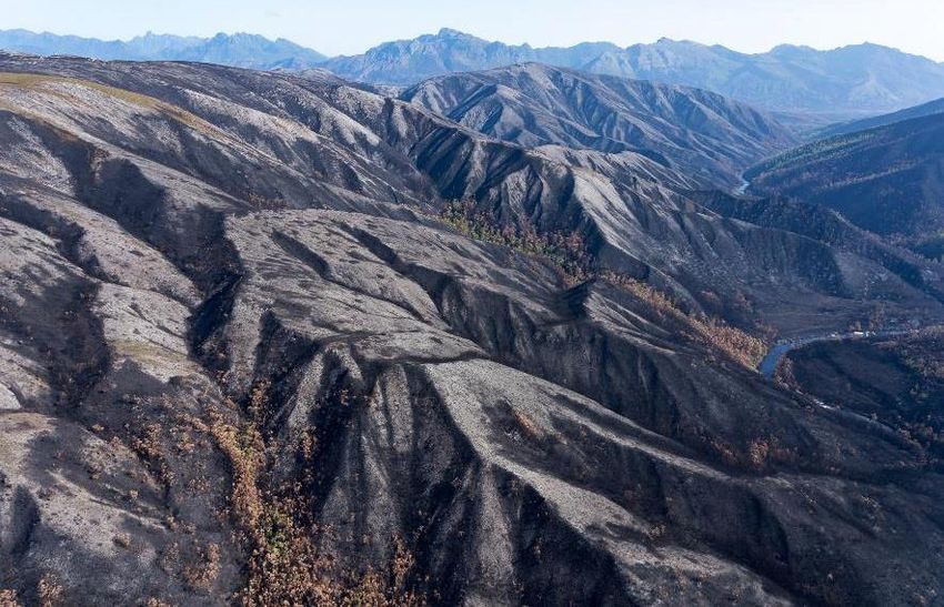
Burnt alpine vegetation on the Crest Range, Mt Bobs beyond. Photo: Grant Dixon

Burnt forest in the Strike Ridge area, Cracroft Valley and Mt Bobs beyond. Photo: Grant Dixon

                                             5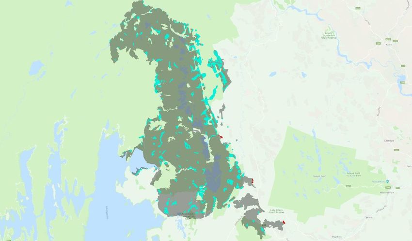
The bigger picture – climate change
Some more to reflect on …
Academic commentators have noted that “dry lightning has set Tasmania ablaze and climate change makes
it more likely to happen again”. There is more on this topic here.
And writer Richard Flanagan provides another, eloquently argued, perspective on the then-current situation,
not just in Tasmania but globally, here.

Some observations
The previous near-disastrous fires in the TWWHA occurred in 2016 and several inquiries resulted; for
example, see here. A range of recommendations were made but arguably have not been effectively
implemented (for example, increased remote area fire fighting capacity).
There has been criticism of the lack of an effective early response to the Gell River (Denison Range – Vale of
Rasselas) fire in particular, which commenced at the end of December and was the only fire burning until the
multiple dry lightning strikes on 15th January. It subsequently became a major part of the TWWHA
conflagration.
Furthermore, some have argued that priorities were misguided and resources inadequate for remote
suppression, and that the incremental rather than catastrophic losses to natural values this year was due to
good luck not good management.

The fires this summer have also highlighted another fire management related issue, that of fuel reduction
burning (or other management burning). In some areas (e.g. southern Arthur Plains – Cracroft valley area)
the fires this summer have re-burnt areas that have had wildfires in the last few to c. 40 years. It leads one to
question how useful burning is – especially when one looks at the impacts on the natural environment? It
seems that it might not be that effective in modern Tasmanian conditions, or be required so often as to be
incompatible with natural values conservation.

In this context also, we need to review how natural values are prioritised for fire fighting resources when life
and property, or timber plantations, are considered to be threatened, and the cumulative impact of the loss
of Gondwanan and other fire sensitive vegetation over multiple fire seasons.

Both the Tasmanian Greens, the state ALP and unions have called for an independent review into the
bushfire response, including resourcing levels and the extent of fuel-reduction burns, but the Liberal
government has merely accused them of looking for cheap political points.

Comment
There are also far broader questions that should be debated and addressed regarding what we are trying to
protect and why, and what is practical and the fact that fire seasons like 2018-19 may well be the new norm,
or at least far more common.
Climate change is upon us. Hotter, drier summers with more frequent dry lightning strikes are the new
normal and conditions are likely to get worse. Even in the unlikely event that the world’s leaders get their
act together and stabilise atmospheric greenhouse gases at something close to present levels, the climate
will not return to that of recent centuries in the lifetime of anyone alive today.

This requires us to rethink our response to fire. Is it even desirable, let alone practical, to attempt to
suppress all fires? But, if we leave “nature” to take its course, most of the TWWHA will comprise recently
burned scrub within a few decades, if not sooner (just because we “dodged a bullet” this summer does not
mean that we will be so lucky next time – marginally more severe conditions could easily result in far greater
impacts). Much of Tasmania’s most iconic native vegetation is highly sensitive to fire and mostly located in

                                                       6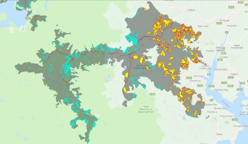
wilderness settings. Its protection will involve increased intervention in wilderness; something which has
been strongly opposed in other contexts. How much intervention can be justified: “management” burns; on-
ground firefighters; sprinklers; aerial water-bombing; drops of fire-retardant (with implications for nearby
ecology); bulldozing of firebreaks? Should we prioritise a few of our most highly valued areas (e.g. the
Gondwanan vegetation of the Northeast Ridge of Mount Anne or Mt Bobs) ahead of everywhere else,
bearing in mind that there will be circumstances when the protection of any specific location may be
impossible? And is there any point, if all that can be achieved is to postpone the inevitable?

There is no simple, obvious answer, but these questions are fundamental to any consideration of how we
deal with fire in the future. The sooner we start thinking about them, the better.

                                                     7
You can also read