Supplements AIP CANADA (ICAO) - nav canada
←
→
Page content transcription
If your browser does not render page correctly, please read the page content below
EFFECTIVE 0901Z 31 DECEMBER 2020
TO   0901Z 28 JANUARY 2021

AIP CANADA (ICAO)

Supplements
Published by NAV CANADA in accordance with ICAO
Annexes 4 and 15 of the Convention on International Civil Aviation

            © 2020 NAV CANADA All rights reserved

                Source of Charts and Maps:
       © 2020 Her Majesty the Queen in Right of Canada
              Department of Natural Resources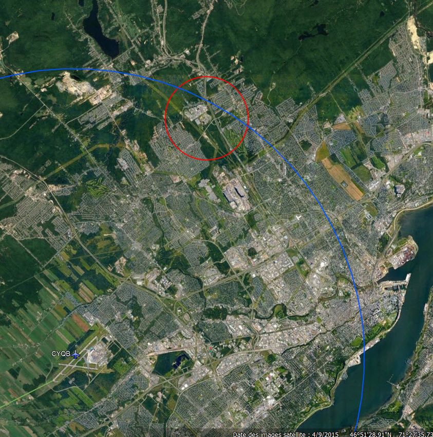
NAV CANADA                                                                                           31 DEC 20

     AIP CANADA (ICAO) SUPPLEMENT SUMMARY 7/20
                                          (Supersedes all previous summaries)
The following supplements are in effect:
          40/16       Blasting Activity—Fort St. John, British Columbia
          4/17        Blasting Activity—Fort St. John, British Columbia
          5/17        Blasting Activity—Mackenzie, British Columbia
          11/17       Quebec Region–Mont Sainte-Marguerite, QC Wind Turbine Farm—June 2017 –
                      January 2021
          28/17       Crane—Edmonton, Alberta (Replaces AIP Supplement 21/17)
          32/17       Amendments to: Canada Flight Supplement (CFS) and Canada Water Aerodrome
                      Supplement (CWAS)
          35/17       Tower Crane—Waterloo, Ontario
          37/17       Multiple Cranes—Fort Saskatchewan, Alberta
          11/18       Meteorological Tower—Arviat, Nunavut
          24/18       Blasting Zone—Bloodvein, Manitoba (Replaces AIP Supplement 37/12)
          26/18       Adjustment to the Canada Air Defence Identification Zone (Replaces AIC 2/18)
          43/18       Multiple Cranes—Saskatoon, Saskatchewan
          7/19        Quebec Region—Cranes for the Construction of the New Champlain Bridge—December
                      2018 – June 2019 (Replaces AIP Supplement 4/18)
          22/19       Multiple Drilling Rigs—Conklin, Alberta
          24/19       Multiple Drilling Rigs—Conklin, Alberta
          25/19       Multiple Cranes—Scotford, Alberta
          31/19       Multiple Drilling Rigs—Conklin, Alberta
          40/19       Crane—Saskatoon, Saskatchewan
          59/19       Multiple Cranes—Winnipeg, Manitoba
          67/19       Crane—Winnipeg, Manitoba
          81/19       Blasting—Sacre-Coeur and Bergeronnes, Quebec
          84/19       Crane—Barrie, Ontario
          2/20        Multiple Cranes—Kelowna, British Columbia
          15/20       Quebec Region—Restrictions to Airspace Over 10 Provincial Detention Facilities
                      (Replaces AIP Supplement 20/19)
          23/20       Ontario Region—Laser Projection in the Vicinity of Egbert, Ontario—January 31, 2020 to
                      January 31, 2025 (Replaces AIP Supplement 51/14)
          27/20       Multiple Cranes—Placentia, Newfoundland (Replaces AIP Supplement 70/19)
          40/20       Implementation of Transponder Airspace at Sioux Lookout Airport (CYXL)—Sioux Lookout,
                      Ontario (Replaces AIC 15/20)
          41/20       Blasting—Baie-Comeau, Quebec
          46/20       Multiple Cranes—Swift Current, Saskatchewan
          50/20       Multiple Cranes—Winnipeg, Manitoba
          51/20       Mobile Crane—Edmonton, Alberta
          52/20       Crane—Edmonton, Alberta

Note: Cette information est aussi disponible dans l’autre langue officielle.                         Page 1 of 2
31 DEC 20

         54/20    Cranes—Within 30 Nautical Miles of Calgary/YYC Calgary Intl Airport
         55/20    Multiple Cranes—Markham, Ontario
         60/20    Multiple Cranes—Fort Saskatchewan, Alberta
         61/20    Crane—Barrie, Ontario
         64/20    Whale Monitoring in the Gulf of Saint Lawrence Conducted by a Remotely Piloted Aircraft
                  System—8 August 2020 to 30 September 2020
         66/20    Mauricie (Quebec)—Creation of a Common Frequency Area
         68/20    Cranes—Within 30 Nautical Miles of Montréal/Pierre Elliott Trudeau Intl Airport (Replaces
                  AIP Supplement 58/20)
         71/20    Modification of Airspace at: Calgary/YYC Calgary Intl Airport (CYYC)—Calgary, Alberta
                  (Replaces AIC 23/20)
         72/20    Change to: Class F Advisory Airspace (CYA621) Active Times—Montreal, Quebec
                  (Replaces AIC 24/20)
         73/20    Multiple Cranes—Kitimat, British Columbia
         74/20    Crane—Esterhazy, Saskatchewan
         79/20    Quebec Region—Montreal / St-Hubert Airport (CYHU)—Mobile Cranes—September 2020
                  to June 2021
         80/20    Tower Crane—Charlottetown, Prince Edward Island
         81/20    Rehabilitation Work: Lac-Etchemin, Quebec (CSC5) (Replaces AIP Canada
                  Supplement 63/20)
         82/20    Opening of the New Air Traffic Control Tower at Red Deer, Alberta (CYQF) (Replaces
                  AIC 29/20)
         83/20    Multiple Cranes—Kitchener, Ontario
         84/20    Cranes—Within 30 Nautical Miles of Toronto/Lester B. Pearson Intl Airport (Replaces AIP
                  Supplement 70/20)
         85/20    Cranes—Within 30 Nautical Miles of Vancouver Intl Airport (Replaces AIP
                  Supplement 75/20)
         86/20    New Taxiway at the Montréal/Pierre Elliott Trudeau International Airport (CYUL) (Replaces
                  AIP Supplement 35/20)

The following A.I.P. Canada Supplements have been cancelled:

         56/19    One Crane—London, Ontario
         34/20    Montréal/Pierre Elliott Trudeau International Airport (CYUL) Reduced Runway Operations
                  from 30 January 2020 to 16 July 2020 (Replaces AIP Canada Supplement 16/20)
         35/20    New Taxiway at the Montréal/Pierre Elliott Trudeau International Airport (CYUL)
         39/20    Terminal 1 Apron Transition Line 7S—Toronto International Airport (CYYZ) (Replaces
                  AIC 34/19)
         48/20    New Visual Flight Rules (VFR) Checkpoints and Arrival Routes at the Toronto/Billy Bishop
                  Toronto City Airport (CYTZ) (Replaces AIP Supplement 37/20)
         59/20    Construction at: Gaspé Michel-Pouliot Airport (CYGP)—Summer 2020
         75/20    Cranes—Within 30 Nautical Miles of Vancouver Intl Airport (Replaces AIP
                  Supplement 67/20)
         76/20    Quebec Region—Eastmain River, QC Airport (CZEM) Construction Work—Beginning
                  September 2020 to End November 2020

Page 2 of 2                                                AIP CANADA (ICAO) SUPPLEMENT SUMMARY 7/20
NAV CANADA                                                                                            31 DEC 20

                  AIP CANADA (ICAO) SUPPLEMENT 86/20

                  NEW TAXIWAY AT THE MONTRÉAL/PIERRE ELLIOTT
                    TRUDEAU INTERNATIONAL AIRPORT (CYUL)
                                           (Replaces AIP Supplement 35/20)

On or around 19 November 2021, the Juliette Charlie Taxiway, which connects the Juliette and Alpha
Taxiways, will open.

              •        The Juliette Charlie Taxiway is under NAV CANADA's jurisdiction.
              •        Traffic is one-way northeast bound.
              •        It can accommodate aircraft with a wingspan of up to 65 metres.
              •        To reduce runway occupancy time (ROT) for Runway 24L, the Juliette Charlie
                       configuration enables aircraft with a wingspan of up to 65 metres to taxi simultaneously.
                       An aircraft, upon landing on Runway 24L, can exit via Alpha 2 while another aircraft is
                       taxiing on Juliette Charlie.

                                                 NOT FOR NAVIGATION

Note: Cette information est aussi disponible dans l’autre langue officielle.                           Page 1 of 2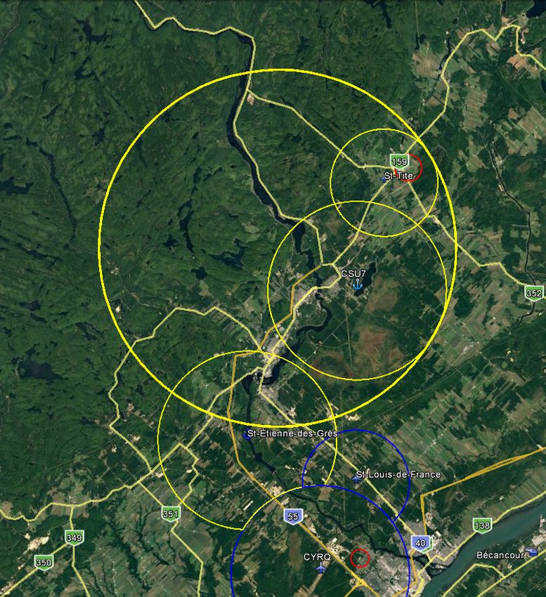
31 DEC 20

For further information, please contact:

              NAV CANADA
              Customer Service
              77 Metcalfe Street
              Ottawa, ON K1P 5L6

              Tel.:      800-876-4693
              Fax:       877-663-6656
              E-mail:    service@navcanada.ca

Stephanie Castonguay
Director, Aeronautical Information Management and Flight Operations

Page 2 of 2                                                           AIP CANADA (ICAO) SUPPLEMENT 86/20
NAV CANADA                                                                                              31 DEC 20

                  AIP CANADA (ICAO) SUPPLEMENT 85/20

                          CRANES—WITHIN 30 NAUTICAL MILES OF
                               VANCOUVER INTL AIRPORT
                                            (Replaces AIP Supplement 75/20)

 The following cranes will be erected within 30 nautical miles (NM) of Vancouver Intl Airport (CYVR).

 An excerpt of aerodrome location indicators and names used in this supplement, taken from the Canada
 Flight Supplement (CFS) and Canada Water Aerodrome Supplement (CWAS), and a list of the abbreviations
 of compass directions, are found in the appendix on the last page of this submission.

 Maximum        Maximum
                                            Painted/       Working                Centre       Distance and Direction
  Height         Height        Lighted
                                            Marking        Radius               Coordinates   from Closest Aerodrome
  (AGL)          (ASL)
259 feet       271 feet       Yes          Yes           410 feet       49° 10' 32ʺ N         1.8 NM ESE of CYVR
                                                                        123° 08' 54ʺ W
262 feet       268 feet       Yes          Yes           261 feet       49° 10' 18" N         2.0 NM ESE of CYVR
                                                                        123° 08' 48" W
186 feet       243 feet       Yes          No            129 feet       49° 15' 52" N         5 NM NNE of CYVR
                                                                        123° 06' 56" W
255 feet       260 feet       Yes          No            435 feet       49° 11' 23ʺ N         1.4 NM ENE of CAM9
                                                                        123° 07' 59ʺ W
432 feet       870 feet       Yes          No            203 feet       49° 13' 21" N         4 NM WSW of CNW9
                                                                        122° 59' 36" W
330 feet       330 feet       Yes          No            1450 feet      49° 17' 24" N         4.5 NM NW of CNW9
                                                                        122° 57' 13" W
446 feet       489 feet       Yes          Unknown       170 feet       49° 17' 08.3034" N    1,635 feet WSW of CBC7
                                                                        123° 06' 46.1177" W
621 feet       727 feet       Yes          No            165 feet       49° 16' 53" N         3,483 feet SW of CBC7
                                                                        123° 07' 05" W
465 feet       475 feet       Yes          No            100 feet       49° 17' 06ʺ N         0.3 NM SW of CBC7
                                                                        123° 06' 46ʺ W
486 feet       600 feet       Yes          No            350 feet       49° 16' 51" N         0.5 NM SSW of CBC7
                                                                        123° 06' 50" W
512 feet       573 feet       No           No            164 feet       49° 16' 37" N         0.9 NM SSW of CBC7
                                                                        123° 07' 23" W
304 feet       372 feet       Yes          Yes           132 feet       49° 17' 19" N         1.0 NM W of CBC7
                                                                        123° 07' 53" W
240 feet       259 feet       Yes          Yes           200 feet       49° 17' 21.316" N     1.7 NM ENE of CBC7
                                                                        123° 03' 43.611" W
326 feet       650 feet       No           No            197 feet       49° 19' 19ʺ N         2 NM NNE of CBC7
                                                                        123° 04' 11ʺ W

 Note: Cette information est aussi disponible dans l’autre langue officielle.                             Page 1 of 4
31 DEC 20

 Maximum       Maximum
                                       Painted/     Working            Centre             Distance and Direction
  Height        Height      Lighted
                                       Marking      Radius           Coordinates         from Closest Aerodrome
  (AGL)         (ASL)
598 feet       744 feet     Yes       Yes         175 feet      49° 16' 00" N           4 NM E of CBC7
                                                                122° 59' 58" W
591 feet       663 feet     No        No          165 feet      49° 16' 34" N           5,392 feet NNW of CBK4
                                                                123° 07' 51" W
476 feet       723 feet     No        No          430 feet      49° 10' 52" N           0.3 NM NNW of CVS3
                                                                122° 50' 40" W
361 feet       1,044 feet   Yes       No          246 feet      49° 20' 58" N           4.9 NM WNW of CYHC
                                                                123° 12' 09" W
408 feet       510 feet     Yes       No          246 feet      49°17' 17" N            5,185 feet SW of CYHC
                                                                123° 07' 51" W
161 feet       190 feet     Yes       Yes         138 feet      49° 06' 10" N           5,210 feet before
                                                                122° 39' 20" W          displaced Threshold 07
                                                                                        and 210 feet S of
                                                                                        extended runway
                                                                                        centreline of CYNJ
257 feet       257 feet     Yes       No          461 feet      49° 10' 36" N           3,540 feet before
                                                                123° 08' 51" W          Threshold 26L and
                                                                                        2,360 feet S of extended
                                                                                        runway centreline of
                                                                                        CYVR

 The following are for new cranes to this AIP Supplement.

 Maximum       Maximum
                                       Painted/     Working            Centre             Distance and Direction
  Height        Height      Lighted
                                       Marking      Radius           Coordinates         from Closest Aerodrome
  (AGL)         (ASL)
168 feet       176 feet     Yes       No          235 feet      49° 11' 11" N           7,310 feet before
                                                                123° 07' 44" W          Threshold 26L and
                                                                                        1,910 feet N of extended
                                                                                        runway centreline of
                                                                                        CYVR
622 feet       685 feet     Yes       Yes         165 feet      49° 17' 13.686" N       3,382 feet SSW CYHC
                                                                123° 07' 13.0044" W

 This is not an exhaustive list. For other crane information, check other active NOTAMs for your flight.

 Page 2 of 4                                                             AIP CANADA (ICAO) SUPPLEMENT 85/20
31 DEC 20

Details of any procedure changes implemented due to crane activity will be promulgated via NOTAM,
publication amendment, or both.

For further information, please contact:

            NAV CANADA
            1601 Tom Roberts Avenue
            Ottawa, ON K1V 1E5

            Tel.:        866-577-0247
            Fax:         613-248-4094
            E-mail:      landuse@navcanada.ca

Stephanie Castonguay
Director, Aeronautical Information Management and Flight Operations

AIP CANADA (ICAO) SUPPLEMENT 85/20                                                             Page 3 of 4
31 DEC 20

Appendix
Aerodrome Location Indicators and Names
 CAM9         Vancouver Intl (Water Aerodrome)
 CBC7         Vancouver/Harbour (Public) (Heli)
 CBK4         Vancouver (Gen Hosp) (Heli)
 CNW9         Vancouver/New Westminster (Royal Columbian Hosp) (Heli)
 CVS3         Vancouver (Surrey Memorial Hosp) (Heli)
 CYHC         Vancouver Harbour (Water Aerodrome)
 CYVR         Vancouver Intl

Abbreviations of Compass Directions
       N      north                           S     south
     NNE      north northeast               SSW     south southwest
      NE      northeast                      SW     southwest
     ENE      east northeast                WSW     west southwest
       E      east                           W      west
     ESE      east southeast                WNW     west northwest
      SE      southeast                     NW      northwest
     SSE      south southeast               NNW     north northwest

Page 4 of 4                                                     AIP CANADA (ICAO) SUPPLEMENT 85/20
NAV CANADA 03 DEC 20
AIP CANADA (ICAO) SUPPLEMENT 84/20
CRANES—WITHIN 30 NAUTICAL MILES OF
TORONTO/LESTER B. PEARSON INTL AIRPORT
(Replaces AIP Supplement 70/20)
The following cranes will be erected within 30 nautical miles (NM) of Toronto/Lester B. Pearson Intl (CYYZ).
An excerpt of aerodrome location indicators and names used in this supplement, taken from the Canada
Flight Supplement (CFS) and Canada Water Aerodrome Supplement (CWAS), and a list of the abbreviations
of compass directions, are found in the appendix on the last page of this submission.
Maximum Maximum
Painted/ Working Centre Distance and Direction from
Height Height Lighted
Marking Radius Coordinates Closest Aerodrome
(AGL) (ASL)
427 feet 867 feet No No 410 feet 43° 38' 20.508" N 3.9 NM SE of CYYZ
79° 33' 32.058" W
424 feet 995 feet Yes No 260 feet 43° 36' 34.20" N 4.2 NM SSW of CYYZ
79° 39' 20.53" W
372 feet 793 feet Yes Yes 215 feet 43° 38' 01.9248" N 4.6 NM SE of CYYZ
79° 32' 29.7384" W
110 feet 671 feet Yes No 813 feet 43° 40' 46.65" N 1,800 feet beyond displaced
79° 36' 28.0073" W Threshold 24R and 2,090 feet NW
runway centreline of CYYZ
336 feet 642 feet Yes Yes 195 feet 43° 39' 25.26ʺ N 4,690 feet before Threshold 26 and
79° 22' 56.555ʺ W 8,420 feet north extended runway
centreline of CYTZ
688 feet 1,034 feet No No 230 feet 43° 39' 47.52" N 5,160 feet before Threshold 26 and
79° 23' 00.86" W 10,720 feet north extended runway
centreline of CYTZ
431 feet 770 feet Yes No 109 feet 43° 39' 30.8708ʺ N 1,620 feet before Threshold 26 and
79° 23' 43.7298ʺ W 10,110 feet north extended runway
centreline of CYTZ
670 feet 1,011 feet Yes No 165 feet 43° 39' 45.7268ʺ N 4,960 feet before Threshold 26 and
79° 23' 02.9398ʺ W 10,580 feet north extended runway
centreline of CYTZ
1,199 feet 1,579 feet Yes No 185 feet 43° 40' 11.5065" N 5,110 feet before Threshold 26 and
79° 23' 13.1647" W 13,310 feet north extended runway
centreline of CYTZ
773 feet 1,151 feet Yes No 218 feet 43° 40' 18.19" N 7,670 feet before Threshold 26 and
79° 22' 38.51" W 13,090 feet north extended runway
centreline of CYTZ
382 feet 773 feet No No 245 feet 43° 40' 28.5874" N 2,540 feet before Threshold 26 and
79° 23' 57.5595ʺ W 16,010 feet north extended runway
centreline of CYTZ
Note: Cette information est aussi disponible dans l’autre langue officielle. Page 1 of 703 DEC 20
Maximum Maximum
Painted/ Working Centre Distance and Direction from
Height Height Lighted
Marking Radius Coordinates Closest Aerodrome
(AGL) (ASL)
305 feet 700 feet No No 222 feet 43° 40' 17.5" N 50 feet beyond Threshold 08 and
79° 25' 25.705" W 17,030 feet north runway centreline
of CYTZ
338 feet 834 feet No No 132 feet 43° 41' 11.9" N 3.5 NM N of CYTZ
79° 24' 10.1" W
330 feet 629 feet No No 98 feet 43° 38' 52.53" N 100 feet beyond Threshold 26 and
79° 23' 50.88" W 6,620 feet north runway centreline
of CYTZ
616 feet 893 feet Yes No 266 feet 43° 38' 20.61" N 220 feet before Threshold 08 and
79° 24' 35.155" W 4,590 feet north extended runway
centreline of CYTZ
591 feet 870 feet Yes No 215 feet 43° 38' 43.9674" N 1,340 feet before Threshold 26 and
79° 23' 25.8216" W 5,170 feet north extended runway
centreline of CYTZ
871 feet 1,157 feet Yes Yes 164 feet 43° 38' 53.4543" N 2,260 feet before Threshold 26 and
79° 23' 17.0110" W 5,820 feet north extended runway
centreline of CYTZ
925 feet 1,232 feet Yes No 304 feet 43° 39' 12.3376" N 2,600 feet before Threshold 26 and
79° 23' 21.4305" W 7,740 feet north extended runway
centreline of CYTZ
512 feet 816 feet Yes Yes 271 feet 43° 39' 14.60" N 3,460 feet before Threshold 26 and
79° 23' 09.95" W 7,770 feet north extended runway
centreline of CYTZ
1,119 feet 1,432 feet Yes No 240 feet 43° 39' 31.2462" N 5,160 feet before Threshold 26 and
79° 22' 53.4458" W 8,900 feet north extended runway
centreline of CYTZ
499 feet 784 feet Yes No 164 feet 43° 38' 19.3961ʺ N 710 feet before Threshold 08 and
79° 24' 41.3873ʺ W 4,540 feet north extended runway
centreline of CYTZ
647 feet 929 feet Yes No 115 feet 43° 38' 44.67" N 890 feet before Threshold 26 and
79° 23' 33.01" W 5,430 feet north extended runway
centreline of CYTZ
843 feet 1,096 feet Yes Yes 270 feet 43° 38' 40.968ʺ N 6,040 feet before Threshold 26 and
79° 22' 17.3398ʺ W 3,250 feet north extended runway
centreline of CYTZ
981 feet 1,235 feet Yes Yes 370 feet 43° 38' 38.395" N 4,410 feet before Threshold 26 and
79° 22' 38.860" W 3,480 feet north extended runway
centreline of CYTZ
368 feet 647 feet Yes No 240 feet 43° 39' 35.87" N 11,160 feet before Threshold 26
79° 21' 29.24" W and 7,400 feet north extended
runway centreline of CYTZ
626 feet 1,007 feet Yes No 300 feet 43° 40' 18.0599" N 9,060 feet before Threshold 26 and
79° 22' 19.0152" W 12,620 feet north extended runway
centreline of CYTZ
Page 2 of 7 AIP CANADA (ICAO) SUPPLEMENT 84/2003 DEC 20
Maximum Maximum
Painted/ Working Centre Distance and Direction from
Height Height Lighted
Marking Radius Coordinates Closest Aerodrome
(AGL) (ASL)
769 feet 1,049 feet Yes No 247 feet 43° 38' 34.55" N Abeam Threshold 26 and
79° 23' 40.75" W 4,660 feet north runway centreline
of CYTZ
433 feet 714 feet Yes Yes 164 feet 43° 38' 33.5" N 240 feet beyond Threshold 26 and
79° 23' 43.7" W 4,630 feet north runway centreline
of CYTZ
584 feet 867 feet Yes No 148 feet 43° 38' 41ʺ N 270 feet before Threshold 26 and
79° 23' 40ʺ W 5,210 feet north extended runway
centreline of CYTZ
449 feet 728 feet No No 150 feet 43° 38' 22.5636ʺ N 510 feet before Threshold 08 and
79° 24' 40.2589" W 4,900 feet north extended runway
centreline of CYTZ
304 feet 613 feet Yes No 335 feet 43° 38' 39.3619ʺ N 4,640 feet before Threshold 08 and
79° 25' 46.7056ʺ W 8,020 feet north extended runway
centreline of CYTZ
459 feet 717 feet Yes Yes 425 feet 43° 39' 04.6057" N 10,780 feet before threshold 26 and
79° 21' 20.0740" W 4,210 feet north extended runway
centreline of CYTZ
392 feet 673 feet Yes Yes 172 feet 43° 38' 17.85" N 2,060 feet before Threshold 08 and
79° 25' 00.115" W 4,890 feet north extended runway
centreline of CYTZ
592 feet 844 feet Yes No 260 feet 43° 38' 37.4ʺ N 5,980 feet before Threshold 26 and
79° 22' 16.1ʺ W 2,840 feet north extended runway
centreline of CYTZ
575 feet 828 feet Yes Yes 305 feet 43° 38' 38.7510ʺ N 7,080 feet before Threshold 26 and
79° 22' 02.2476ʺ W 2,680 feet north extended runway
centreline of CYTZ
421 feet 692 feet Yes No 225 feet 43° 39' 15.305" N 9,160 feet before Threshold 26 and
79° 21' 48.15" W 5,830 feet north extended runway
centreline of CYTZ
591 feet 954 feet Yes No 230 feet 43° 39' 59.4490ʺ N 5,240 feet before Threshold 26 and
79° 23' 05.0325ʺ W 11,880 feet north extended runway
centreline of CYTZ
479 feet 851 feet Yes Yes 310 feet 43° 39' 51.6589ʺ N 1,720 feet beyond Threshold 26
79° 24' 41.5858ʺ W and 13,490 feet north runway
centreline of CYTZ
489 feet 861 feet No No 271 feet 43° 39' 28.5273" N 8,570 feet before Threshold 08 and
79° 27' 06.5998" W 14,710 feet north extended runway
centreline of CYTZ
628 feet 895 feet Yes No 220 feet 43° 37' 28.8246" N 3.6 NM W of CYTZ
79° 28' 44.9469" W
707 feet 1088 feet No Yes 119 feet 43° 40' 16.0258" N 5,100 feet before Threshold 26 and
79° 23' 15.2343" W 13,740 feet north extended runway
centreline of CYTZ
AIP CANADA (ICAO) SUPPLEMENT 84/20 Page 3 of 703 DEC 20
Maximum Maximum
Painted/ Working Centre Distance and Direction from
Height Height Lighted
Marking Radius Coordinates Closest Aerodrome
(AGL) (ASL)
531 feet 784 feet No No 132 feet 43° 38' 48" N 5,710 feet before Threshold 26 and
79° 22' 24.5" W 4,110 feet north extended runway
centreline of CYTZ
461 feet 1,132 feet Yes No 342 feet 43° 50' 26.0208" N 8,570 feet before Threshold 03 and
79° 23' 48.7280" W 3,650 feet NW extended runway
centreline of CYKZ
289 feet 967 feet Yes No 162 feet 43° 50' 41.5" N 10,040 feet before Threshold 03
79° 25' 37.1" W and 11,580 feet NW extended
runway centreline of CYKZ
302 feet 860 feet Yes No 214 feet 43° 42' 03ʺ N 14,950 feet before Threshold 33
79° 25' 34ʺ W and 1,310 feet SW extended
runway centreline of CYZD
493 feet 1,005 feet Yes Yes 300 feet 43° 46' 01" N 4.3 NM E of CYZD
79° 22' 19" W
427 feet 1,053 feet Yes No 148 feet 43° 46' 39.6" N 1,920 feet beyond Threshold 15
79° 24' 49.9" W and 18,660 feet NE of runway
centreline of CYZD
320 feet 872 feet Yes Yes 92 feet 43° 41' 48.8949" N 13,140 feet before Threshold 33
79° 26' 37.6942" W and 5,870 feet SW extended
runway centreline of CYZD
491 feet 1,016 feet Yes Yes 210 feet 43° 46' 26.8556ʺ N 2,780 feet beyond Threshold 15
79° 24' 54.1104ʺ W and 17,610 feet NE runway
centreline of CYZD
597 feet 1,104 feet Yes No 115 feet 43° 42' 28.84" N 3.6 NM SE of CYZD
79° 23' 49.96" W
361 feet 1,073 feet Yes No 245 feet 43° 49' 33.8393" N 6 NM NNW of CYZD
79° 31' 56.4386" W
474 feet 1,000 feet Yes No 131 feet 43° 42' 37.0074ʺ N 3.7 NM SE of CYZD
79° 23' 38.6586ʺ W
429 feet 1,056 feet Yes No 335 feet 43° 47' 07.55" N 670 feet before Threshold 15
79° 24' 57.9" W and19,960 feet NE extended
runway centreline of CYZD
626 feet 1,300 feet Yes Yes 153 feet 43° 47' 44.10" N 4 NM NNW of CYZD
79° 31' 19.05" W
342 feet 868 feet No No 226 feet 43° 45' 59.70" N 4.2 NM E of CYZD
79° 22' 26.09" W
552 feet 1,068 feet Yes No 270 feet 43° 35' 12.7827" N 3.9 NM S of CPA5
79° 38' 45.5631" W
450 feet 1,025 feet No No 335 feet 43° 33' 23.7492" N 2,235 feet SW of CPK6
79° 42' 29.2572" W
319 feet 912 feet Yes Yes 181 feet 43° 48' 32.5" N 4.6 NM SSW of CPH7
79° 15' 52.5" W
Page 4 of 7 AIP CANADA (ICAO) SUPPLEMENT 84/2003 DEC 20
Maximum Maximum
Painted/ Working Centre Distance and Direction from
Height Height Lighted
Marking Radius Coordinates Closest Aerodrome
(AGL) (ASL)
360 feet 652 feet Yes No 200 feet 43 °37’ 26.1493" N 3.3 NM E of CPY5
79° 29’ 20.3883" W
565 feet 1,024 feet Yes No 254 feet 43° 35' 23.0027ʺ N 3.4 NM WSW of CPY5
79° 37' 55.1219ʺ W
474 feet 864 feet Yes No 300 feet 43° 39' 40.695" N 3.5 NM NE of CPY5
79° 30' 42.060" W
711 feet 1,223 feet Yes No 412 feet 43° 35' 03.1096" N 4.1 NM WSW of CPY5
79° 38' 40.3382" W
486 feet 1,043 feet No No 210 feet 43° 46' 48ʺ N 5 NM ENE of CNY8
79° 16' 55.33ʺ W
902 feet 1,386 feet Yes Yes 395 feet 43° 43' 57ʺ N 1.27 NM ENE of CNY8
79° 20' 40.5ʺ W
352 feet 889 feet Yes No 245 feet 43° 45' 33.5" N 2.8 NM NE of CNY8
79° 19' 55.7" W
The following are for new cranes to this AIP Supplement.
Maximum Maximum
Painted/ Working Centre Distance and Direction from
Height Height Lighted
Marking Radius Coordinates Closest Aerodrome
(AGL) (ASL)
706 feet 1,228 feet Yes No 325 feet 43° 35' 17.265" N 3.9NM S of CPA5
79° 39' 01.11" W
181 feet 797 feet Yes Yes 318 feet 43° 43' 57.115" N 2,290 feet before Threshold 33 and
79° 26' 52.665" W 1,330 feet NE extended runway
centreline of CYZD
712 feet 991 feet Yes No 413 feet 43° 38' 34.1882" N 450 feet beyond Threshold 26 and
79° 23' 46.5143" W 4,700 feet north runway centreline
of CYTZ
636 feet 927 feet Yes No 131 feet 43° 38' 53.6" N 1,320 feet before Threshold 26 and
79° 23' 31.1" W 6,250 feet north extended runway
centreline of CYTZ
493 feet 766 feet Yes No 140 feet 43° 39' 38.05" N 11,650 feet before Threshold 26
79° 21' 22.79" W and 7,450 feet north extended
runway centreline of CYTZ
322 feet 863 feet Yes No 197 feet 43° 43' 07.430" N 14,090 feet before Threshold 33
79°24' 00.732" W and 8,070 feet NE extended
runway centreline of CYZD
This is not an exhaustive list. For other crane information, check other active NOTAMs for your flight.
AIP CANADA (ICAO) SUPPLEMENT 84/20 Page 5 of 703 DEC 20
Details of any procedure changes implemented due to crane activity will be promulgated via NOTAM,
publication amendment, or both.
For further information, please contact:
NAV CANADA
1601 Tom Roberts Avenue
Ottawa, ON K1V 1E5
Tel.: 866-577-0247
Fax: 613-248-4094
E-mail: landuse@navcanada.ca
Stephanie Castonguay
Director, Aeronautical Information Management and Flight Operations
Page 6 of 7 AIP CANADA (ICAO) SUPPLEMENT 84/2003 DEC 20
Appendix
Aerodrome Location Indicators and Names
CNW8 Toronto (Hosp for Sick Children) (Heli)
CNY8 Toronto (Sunnybrook Medical Ctr) (Heli)
CPA5 Toronto/Tarten (Heli)
CPH7 Toronto/Markham Stouffville (Heli)
CPK6 Toronto (Mississauga Credit Valley Hosp) (Heli)
CPY5 Toronto/Wilson’s (Heli)
CPZ9 Toronto/ Billy Bishop Toronto City Airport (Water Aerodrome)
CTM4 Toronto (St. Michael’s Hosp) (Heli)
CYKZ Toronto/Buttonville Muni
CYTZ Toronto/Billy Bishop Toronto City Airport
CYYZ Toronto/Lester B. Pearson Intl
CYZD Toronto/Downsview
Abbreviations of Compass Directions
N north S south
NNE north northeast SSW south southwest
NE northeast SW southwest
ENE east northeast WSW west southwest
E east W west
ESE east southeast WNW west northwest
SE southeast NW northwest
SSE south southeast NNW north northwest
AIP CANADA (ICAO) SUPPLEMENT 84/20 Page 7 of 7NAV CANADA 03 DEC 20
AIP CANADA (ICAO) SUPPLEMENT 83/20
MULTIPLE CRANES—KITCHENER, ONTARIO
Multiple cranes will be erected in Kitchener, Ontario. The maximum height is 385 feet above ground level
(AGL) or 1,499 feet above sea level (ASL). The structures will be lighted, but not painted.
The cranes will be located within a 302-foot radius, centred at the following coordinates:
43° 27' 12.905" N 80° 30' 10.37" W
Multiple cranes are approximately 365 feet northeast (NE) of Grand River Hospital Heliport (CNK9). Details of
any procedure changes implemented due to this crane activity will be promulgated via NOTAM, publication
amendment, or both.
For further information, please contact:
NAV CANADA
1601 Tom Roberts Avenue
Ottawa, ON K1V 1E5
Tel.: 866-577-0247
Fax: 613-248-4094
E-mail: landuse@navcanada.ca
Stephanie Castonguay
Director, Aeronautical Information Management and Flight Operations
Note: Cette information est aussi disponible dans l’autre langue officielle. Page 1 of 1NAV CANADA 05 NOV 20
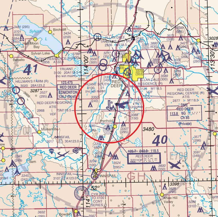
AIP CANADA (ICAO) SUPPLEMENT 82/20
OPENING OF THE NEW AIR TRAFFIC
CONTROL TOWER AT RED DEER, ALBERTA (CYQF)
(Replaces AIC 29/20)
In 2018, NAV CANADA, the country's provider of civil air navigation services, conducted an aeronautical
study that reviewed the air traffic service (ATS) and airspace requirements at the Red Deer Regional Airport
(CYQF) [see figure on the following page]. The study had concluded that the current airspace structure and
level of ATS — Aerodrome Advisory Service (AAS) — was appropriate. Several risk mitigation measures
were put in place to enhance safety and efficiency of aircraft operations. Among others, additional guidance
for pilots was published in the Canada Flight Supplement (CFS) VFR (visual flight rules) Terminal Procedures
Charts (VTPC) on 20 June 2019.
A 90-day post implementation review of these procedures along with the continued monitoring of traffic levels
was conducted. The review concluded that a conversion to air traffic control (ATC) service was warranted.
An ATC tower will be in operation for 16 hours per day from 1300 to 0500 Coordinated Universal Time (UTC)
(1200 to 0400 UTC during daylight savings time) using the current mandatory frequency (MF) 118.5 MHz.
The control zone (CZ) will become Class D airspace for the 16 hours per day when the tower is in operation.
The flight service station (FSS) will be in operation for 8 hours a day on the same frequency, 118.5 MHz, from
0500 to 1300 UTC (0400 to 1200 UTC during daylight savings time) and the CZ will become Class E airspace
with a MF.
Ground control service during ATC tower operating hours will be provided on 121.9 MHz. Ground advisory
service during FSS operating hours will be provided on the MF frequency 118.5 MHz. An automatic terminal
information service (ATIS) will broadcast on 124.0 MHz 24 hours per day.
These changes are planned to take effect 5 November 2020 at 0901 UTC. The appropriate aeronautical
publications will be amended. Refer to this supplement until the next editions of the Calgary and Edmonton
VFR navigation charts (VNC) AIR 5005 and AIR 5015 are available in April 2021.
Note: Cette information est aussi disponible dans l’autre langue officielle. Page 1 of 205 NOV 20
NOT FOR NAVIGATION
For further information, please contact:
NAV CANADA
Customer Service
77 Metcalfe Street
Ottawa, ON K1P 5L6
Tel.: 800-876-4693
Fax: 877-663-6656
E-mail: service@navcanada.ca
Stephanie Castonguay
Director, Aeronautical Information Management and Flight Operations
Page 2 of 2 AIP CANADA (ICAO) SUPPLEMENT 82/20NAV CANADA 05 NOV 20
AIP CANADA (ICAO) SUPPLEMENT 81/20
REHABILITATION WORK:
LAC-ETCHEMIN, QUEBEC (CSC5)
(Replaces AIP Canada Supplement 63/20)
Due to ongoing rehabilitation work in Lac-Etchemin, Quebec (CSC5), the local airport authority has restricted
accessibility to Runway 06/24. Runway 06/24 is closed, and the signage will remain in place until the work is
completed on 31 May 2021.
For further information, please contact:
Municipality of Lac-Etchemin
208, 2nd Avenue
Lac-Etchemin (Quebec) G0R 1S0
Attention: Eric Guenette, Director
Public Services Urban Planning and Environment
Tel.: 418-625-4521 ext. 233
Fax: 418-625-3175
E-mail: munetchemin.eg@sogetel.net
Stephanie Castonguay
Director, Aeronautical Information Management and Flight Operations
Note: Cette information est aussi disponible dans l’autre langue officielle. Page 1 of 1NAV CANADA 05 NOV 20
AIP CANADA (ICAO) SUPPLEMENT 80/20
TOWER CRANE
CHARLOTTETOWN, PRINCE EDWARD ISLAND
A tower crane will be erected in Charlottetown, Prince Edward Island. The maximum height is 144 feet above
ground level (AGL) or 225 feet above sea level (ASL). The structure will not be lighted and not painted.
The cranes will be located within a 260-foot radius centred at the following coordinates:
46° 15' 12.5883" N 63° 08' 20.4506" W
The tower crane is approximately 1.67 nautical miles (NM) west northwest (WNW) Charlottetown Queen
Elizabeth Hospital Heliport (CDV3). Details of any procedure changes implemented due to this crane activity
will be promulgated via NOTAM, publication amendment, or both.
For further information, please contact:
NAV CANADA
1601 Tom Roberts Avenue
Ottawa, ON K1V 1E5
Tel.: 866-577-0247
Fax: 613-248-4094
E-mail: landuse@navcanada.ca
Stephanie Castonguay
Director, Aeronautical Information Management and Flight Operations
Note: Cette information est aussi disponible dans l’autre langue officielle. Page 1 of 108 OCT 20
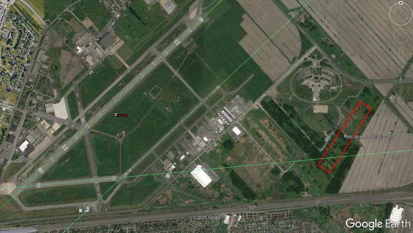
AIP CANADA (ICAO) SUPPLEMENT 79/20
QUEBEC REGION
MONTREAL / ST-HUBERT AIRPORT (CYHU)
MOBILE CRANES—SEPTEMBER 2020 TO JUNE 2021
The use of mobiles cranes located southeast of the St-Hubert airport will start September 21st 2020 and will
go on until late May / early June. The maximum height of the cranes will be 140 feet above ground level
(AGL) or approximatively 220 feet above sea level (ASL). Those works will allow the construction of a new
building and will necessitate the use of up to 4 mobile cranes within the area indicated by a red rectangle on
the chart below. This building is located at approximatively 6000 feet before the runway 28 threshold.
Those cranes will be in use daily on weekdays between 06h00 and 17h00 local time, occasionally at night or
on weekends by NOTAM. The cranes will be lighted and marked. No impact on the daily airport operations.
The coordinates of the center of the building are the following:
45° 30' 56.70" N 73° 23' 24.75" W
Bernard Fortin
Associate Director, Operations
Civil Aviation – NAH
Transport Canada, Quebec Region
Note: Cette information est aussi disponible dans l’autre langue officielle. Page 1 of 1NAV CANADA 10 SEP 20
AIP CANADA (ICAO) SUPPLEMENT 74/20
CRANE—ESTERHAZY, SASKATCHEWAN
A crane will be erected in Esterhazy, Saskatchewan. The maximum height is 453 feet above ground level
(AGL) or 2,149 feet above sea level (ASL). The structure will be lighted, but not painted.
The crane will be located within a 197-foot radius centred at the following coordinates:
50° 38' 41" N 101° 59' 39" W
The crane is approximately 4 nautical miles (NM) east (E) of Esterhazy Airport (CJK4). Details of any
procedure changes implemented due to this crane activity will be promulgated via NOTAM, publication
amendment, or both.
For further information, please contact:
NAV CANADA
1601 Tom Roberts Avenue
Ottawa, ON K1V 1E5
Tel.: 866-577-0247
Fax: 613-248-4094
E-mail: landuse@navcanada.ca
James Ferrier
Director, Aeronautical Information Management and Flight Operations
Note: Cette information est aussi disponible dans l’autre langue officielle. Page 1 of 1NAV CANADA 10 SEP 20
AIP CANADA (ICAO) SUPPLEMENT 73/20
MULTIPLE CRANES—KITIMAT, BRITISH COLUMBIA
Multiple cranes will be erected in Kitimat, British Columbia. The maximum height is 333 feet above ground
level (AGL) or 350 feet above sea level (ASL). The structures will be lighted and painted.
The cranes will be located within a 502-foot radius centred at the following coordinates:
54° 01' 02.1126" N 128° 41' 07.8896" W
Multiple cranes are approximately 10 nautical miles (NM) south (S) of Kitimat Airport (CBW2). Details of any
procedure changes implemented due to this crane activity will be promulgated via NOTAM, publication
amendment, or both.
For further information, please contact:
NAV CANADA
1601 Tom Roberts Avenue
Ottawa, ON K1V 1E5
Tel.: 866-577-0247
Fax: 613-248-4094
E-mail: landuse@navcanada.ca
James Ferrier
Director, Aeronautical Information Management and Flight Operations
Note: Cette information est aussi disponible dans l’autre langue officielle. Page 1 of 1NAV CANADA 10 SEP 20
AIP CANADA (ICAO) SUPPLEMENT 72/20
CHANGE TO:
CLASS F ADVISORY AIRSPACE (CYA621) ACTIVE TIMES
MONTREAL, QUEBEC
(Replaces AIC 24/20)
The user agency has requested a change to the active times of the Class F advisory airspace (CYA621),
35 nautical miles (NM) east of Montreal.
CYA621 will become active continuously during daylight hours.
This change will take effect on 10 September 2020 at 0901 Coordinated Universal Time (UTC). The
appropriate aeronautical publications will be amended. Refer to this supplement until the next editions of the
Montreal VFR (visual flight rules) navigation chart (VNC) and VFR terminal area charts (VTA) (AIR 5002 and
AIR 1903) are available in 2021.
For further information, please contact:
NAV CANADA
Customer Service
77 Metcalfe Street
Ottawa, ON K1P 5L6
Tel.: 800-876-4693
Fax: 877-663-6656
E-mail: service@navcanada.ca
James Ferrier
Director, Aeronautical Information Management and Flight Operations
Note: Cette information est aussi disponible dans l’autre langue officielle. Page 1 of 1NAV CANADA 10 SEP 20
AIP CANADA (ICAO) SUPPLEMENT 71/20
MODIFICATION OF AIRSPACE AT:
CALGARY/YYC CALGARY INTL AIRPORT (CYYC)
CALGARY, ALBERTA
(Replaces AIC 23/20)
NAV CANADA, the country's provider of civil air navigation services, conducted an assessment of the
airspace at the Calgary/YYC Calgary Intl Airport (CYYC). The assessment concluded that the airspace
around the airport should be updated to the new aerodrome geographic centre coordinates (AGCC) to correct
for a shift caused by the completion of an additional runway in 2014.
The following airspace will be updated with the new AGCC (as shown in the figure on the following page):
Control Zone
• Class C: Within a 7 nautical mile (NM) radius from the surface to 6,600 feet above sea
level (ASL).
Terminal Control Areas
• Class C: Within a 15 NM radius, east of the Calgary/Springbank Airport (CYBW) control
zone, 4,800 feet ASL to below 5,500 feet ASL.
• Class C: Within a 20 NM radius, 5,500 feet ASL to below 8,000 feet ASL.
• Class C: An area 20 NM to 24 NM west, 6,000 feet ASL to below 8,000 feet ASL.
• Class C: Within a 30 NM radius, 8,000 feet ASL to 12,500 feet ASL and Class B:
12,500 feet ASL to below 18,000 feet ASL.
• Class B: Within a 30 NM radius, above 12,500 feet ASL to below 18,000 feet ASL.
This change will result in the affected airspace moving approximately 0.6 NM to the northeast.
Note: Cette information est aussi disponible dans l’autre langue officielle. Page 1 of 310 SEP 20
NOT FOR NAVIGATION
These changes will take effect on 10 September 2020 at 0901 Coordinated Universal Time (UTC). The
appropriate aeronautical publications will be amended. Refer to this supplement until the next editions of the
Calgary VFR (visual flight rules) navigation chart (VNC) and VFR terminal area charts (VTA) (AIR 5005 and
AIR 1904) are available in April 2021.
Page 2 of 3 AIP CANADA (ICAO) SUPPLEMENT 71/2010 SEP 20
For further information, please contact:
NAV CANADA
Customer Service
77 Metcalfe Street
Ottawa, ON K1P 5L6
Tel.: 800-876-4693
Fax: 877-663-6656
E-mail: service@navcanada.ca
James Ferrier
Director, Aeronautical Information Management and Flight Operations
AIP CANADA (ICAO) SUPPLEMENT 71/20 Page 3 of 3NAV CANADA 13 AUG 20
AIP CANADA (ICAO) SUPPLEMENT 68/20
CRANES—WITHIN 30 NAUTICAL MILES OF
MONTRÉAL/PIERRE ELLIOTT TRUDEAU INTL AIRPORT
(Replaces AIP Supplement 58/20)
The following cranes will be erected within 30 nautical miles (NM) of Montreal/Pierre Elliott Trudeau Intl (CYUL).
An excerpt of aerodrome location indicators and names used in this supplement, taken from the Canada Flight
Supplement (CFS) and Canada Water Aerodrome Supplement (CWAS), and a list of the abbreviations of
compass directions are found in the appendix on the last page of this submission.
Maximum Maximum
Painted/ Working Centre Distance and Direction from Closest
Height Height Lighted
Marking Radius Coordinates Aerodrome
(AGL) (ASL)
185 feet 287 feet Yes No 250 feet 45° 30' 06" N 8,630 feet before Threshold 24L and
73° 42' 16" W 3,910 feet NW of extended runway
centreline of CYUL
177 feet 307 feet Yes No 170 feet 45° 30' 10" N 14,080 feet before Threshold 24L
73° 40' 29" W and 1,410 feet SE of extended
runway centerline of CYUL
131 feet 233 feet Yes No 480 feet 45° 28' 46" N 1 NM NW of CYUL
73° 45' 35" W
332 feet 441 feet Yes Yes 673 feet 45 °30' 02" N 3.6 NM ENE of CYUL
73° 39' 58" W
170 feet 253 feet No No 1,000 feet 45° 30' 48" N 0.7 NM SE of CYHU
73° 24' 02" W
This is not an exhaustive list. For other crane information, check other active NOTAMs for your flight.
Details of any procedure changes implemented due to crane activity will be promulgated via NOTAM,
publication amendment, or both.
For further information, please contact:
NAV CANADA
1601 Tom Roberts Avenue
Ottawa, ON K1V 1E5
Tel.: 866-577-0247
Fax: 613-248-4094
E-mail: landuse@navcanada.ca
James Ferrier
Director, Aeronautical Information Management and Flight Operations
Note: Cette information est aussi disponible dans l’autre langue officielle. Page 1 of 213 AUG 20
Appendix
Aerodrome Location Indicators and Names
CYHU Montréal/St-Hubert
CYMX Montreal Intl (Mirabel)
CYUL Montréal/Pierre Elliott Trudeau Intl
Abbreviations of Compass Directions
N north S south
NNE north northeast SSW south southwest
NE northeast SW southwest
ENE east northeast WSW west southwest
E east W west
ESE east southeast WNW west northwest
SE southeast NW northwest
SSE south southeast NNW north northwest
Page 2 of 2 AIP CANADA (ICAO) SUPPLEMENT 68/2016 JUL 20
AIP CANADA (ICAO) SUPPLEMENT 66/20
MAURICIE (QUEBEC)
CREATION OF A COMMON FREQUENCY AREA
The Mauricie Region, particularly the area North of Trois-Rivières up to the northern boundary of La Mauricie
National Park, on both sides of the St-Maurice River, is home to a large number of aerial sightseeing flights.
There are also several water aerodromes and land aerodromes in this sector, not counting aircraft coming
from various other areas to enjoy the view of the landscape.
In consideration of the amount of aviation activity, involving aircraft on various frequencies, there is a potential
for conflicts between aircraft who are unaware of the presence or the position of one another.
A common frequency area (CFA) is a designated area within which all pilots should select the assigned radio
frequency, broadcast their position and intentions as well as maintain a listening watch on the frequency.
In order to increase the level of aviation safety in this part of Mauricie, Transport Canada is designating a
Common Frequency Area as follows
1. Within a 10 NM radius of N46 39 23 W72 43 55
2. The area extends upwards from the surface to 3500 feet ASL
3. The frequency to be used by all pilots operating in the CFA is 122.7 MHz
The circle with a 10NM radius encompasses the ATF of Lac-à-à-Tortue (water aerodrome and land
aerodrome) as well as the annual temporary MF for the Festival Western de St-Tite which keep their
frequency.
The CFA extends more than 4 NM inside the ATF area of St-Étienne-des-Grès (CHA2) water aerodrome. For
this reason, the ATF frequency at CHA2 is changed for 122.7 MHz.
The CFA extends more than 1 NM inside the ATF area of St-Louis-de-France (CSJ5). For this reason, the
size of the ATF at CSJ5 is reduced to a 3 NM radius.
A depiction of the Common frequency Area – Mauricie in included hereafter.
Note: Cette information est aussi disponible dans l’autre langue officielle. Page 1 of 216 JUL 20
NOT FOR NAVIGATION PURPOSES
The Common Frequency Area – Mauricie is depicted by the large yellow circle.
The ATF and MF areas also on 122.7 are depicted in smaller yellow circles.
Bernard Fortin
Associate Director, Operations
Civil Aviation – NAH
Transport Canada, Quebec Region
Page 2 of 2 AIP CANADA (ICAO) SUPPLEMENT 66/20NAV CANADA 16 JUL 20
AIP CANADA (ICAO) SUPPLEMENT 64/20
WHALE MONITORING IN THE GULF OF SAINT LAWRENCE
CONDUCTED BY A REMOTELY PILOTED AIRCRAFT SYSTEM
8 AUGUST 2020 TO 30 SEPTEMBER 2020
This supplement aims to inform the aeronautical community operating in the Gulf of Saint Lawrence area about
whale monitoring that will be conducted by a remotely piloted aircraft system (RPAS), along with the resulting
operational limitations and restrictions over and in the vicinity of the Gaspé (Michel-Pouliot) Airport (CYGP).
To increase the level of safety during these operations, and pursuant to section 5.1 of the Aeronautics Act,
Transport Canada is creating restricted areas encompassing the Gaspé Class E control zone, a portion of the
Gaspé transition area, transition corridors and the whale monitoring airspace, which will be active daily during
day light for the proposed dates. Some of the NOTAM airspace may be deactivated on a daily basis when not
in use. Areas are to be considered active unless stated otherwise.
Restricted Areas
Section 5.1 of the Aeronautics Act states that:
“The Minister or any person authorized by the Minister may by notice prohibit or restrict the
operation of aircraft on or over any area or within any airspace, either absolutely or subject to any
exceptions or conditions that the Minister or person may specify [...].”
Pursuant to section 5.1 of the Aeronautics Act, the following restricted areas are planned:
Gaspé Control Zone and Transition Area
The Gaspé control zone and transition area consists of a 15 nautical mile (NM) radius centred on the Gaspé
(Michel-Pouliot) Airport (CYGP) (coordinates: 48° 46' 31" N 64° 28' 43" W), excluding the area south of the
line between 48° 42' 13" N 64° 49' 57" W and 48° 41' 43" N 64° 07' 21" W from the surface to 4,000 feet mean
sea level (MSL).
North Corridor (from the surface to 4,000 feet MSL)
The airspace within the area bounded by a line beginning at:
49° 00' 57" N 64° 34' 37" W to
49° 01' 56" N 64° 34' 31" W to
49° 05' 44" N 64° 30' 47" W to
49° 12' 49" N 64° 11' 48" W to
49° 11' 00" N 64° 00' 00" W to
49° 08' 22" N 63° 53' 02" W to
48° 59' 26" N 64° 17' 23" W to
49° 00' 57" N 64° 34' 37" W point of beginning.
Note: Cette information est aussi disponible dans l’autre langue officielle. Page 1 of 416 JUL 20
East Corridor (from the surface to 4,000 feet MSL)
The airspace within the area bounded by a line beginning at:
48° 51' 46" N 64° 07' 33" W to
48° 51' 55" N 63° 51' 04" W to
48° 41' 57" N 63° 50' 55" W to
48° 41' 47" N 64° 07' 18" W to
48° 51' 46" N 64° 07' 33" W point of beginning.
Area Mike (from 1,500 feet MSL to 5,000 feet MSL)
The airspace within the area bounded by a line beginning at:
49° 41' 00" N 65° 00' 00" W to
49° 22' 00" N 64° 00' 00" W to
49° 11' 00" N 64° 00' 00" W to
49° 20' 00" N 65° 00' 00" W to
49° 41' 00" N 65° 00' 00" W point of beginning.
Area November (from 1,500 feet MSL to 5,000 feet MSL)
The airspace within the area bounded by a line beginning at:
49° 22' 00" N 64° 00' 00" W to
49° 00' 00" N 63° 00' 00" W to
48° 48' 00" N 63° 00' 00" W to
49° 11' 00" N 64° 00' 00" W to
49° 22' 00" N 64° 00' 00" W point of beginning.
Area Oscar (from 1,500 feet MSL to 5,000 feet MSL)
The airspace within the area bounded by a line beginning at:
49° 00' 00" N 63° 00' 00" W to
48° 35' 00" N 62° 00' 00" W to
48° 24' 00" N 62° 00’ 00" W to
48° 48’ 00" N 63° 00’ 00" W to
49° 00' 00" N 63° 00' 00" W point of beginning.
Page 2 of 4 AIP CANADA (ICAO) SUPPLEMENT 64/2016 JUL 20
Area Tango (from 1,500 feet MSL to 5,000 feet MSL)
The airspace within the area bounded by a line beginning at:
49° 07' 42.45" N 63° 51' 18.58" W to
48° 30' 27.54" N 63° 50' 45.41" W to
48° 30' 23.59" N 64° 00' 00" W to
47° 50' 00" N 64° 00' 00" W to
47° 50' 00" N 63° 00' 00" W to
48° 48' 00" N 63° 00' 00" W to
49° 07' 42.45" N 63° 51' 18.58" W point of beginning.
No person shall operate an aircraft, including a remotely piloted aircraft (RPA), such as a drone, within the
areas described unless authorized by the Montreal area control centre (ACC) on 134.175 MHz or at
1-800-633-1353, or by Transport Canada Aircraft Services at 343-542-2924.
The restriction shall be in effect from 8 August 2020 through to 30 September 2020 during daylight hours. The
restricted areas are depicted and on the satellite image in Figure 1.
NOTAM
NOTAMs will be issued, under the Montréal flight information region (FIR) – CZUL (Montréal) NOTAM file and
under the Moncton FIR – CYQM (Moncton/Greater Moncton Roméo LeBlanc Intl) NOTAM file, indicating the
effective times of the restricted areas pursuant to section 5.1 of the Aeronautics Act. NOTAMs will also be
issued, under the Gaspé (Michel-Pouliot) Airport (CYGP) CYQB (Québec/Jean Lesage Intl) NOTAM file,
indicating the effective times of the restricted area pursuant to section 5.1 of the Aeronautics Act as well as
any last-minute changes.
AIP CANADA (ICAO) SUPPLEMENT 64/20 Page 3 of 416 JUL 20
Figure 1: NOT FOR NAVIGATION.
Restricted areas are depicted by the colour shaded areas, as well as inside the red semi-circle.
James Ferrier
Director, Aeronautical Information Management and Flight Operations
Page 4 of 4 AIP CANADA (ICAO) SUPPLEMENT 64/20NAV CANADA 16 JUL 20
AIP CANADA (ICAO) SUPPLEMENT 61/20
CRANE—BARRIE, ONTARIO
A crane will be erected in Barrie, Ontario. The maximum height is 410 feet above ground level (AGL) or 1,253
feet above sea level (ASL). The structure will be lighted and painted.
The crane will be located within 197-foot radius centred at the following coordinates:
44° 21' 19" N 79° 38' 31" W
The crane is approximately 3.7 nautical miles (NM) south (S) of Barrie Royal Victoria Hospital Heliport
(CRV2). Details of any procedure changes implemented due to this crane activity will be promulgated via
NOTAM, publication amendment, or both.
For further information, please contact:
NAV CANADA
1601 Tom Roberts Avenue
Ottawa, ON K1V 1E5
Tel.: 866-577-0247
Fax: 613-248-4094
E-mail: landuse@navcanada.ca
James Ferrier
Director, Aeronautical Information Management and Flight Operations
Note: Cette information est aussi disponible dans l’autre langue officielle. Page 1 of 1NAV CANADA 16 JUL 20
AIP CANADA (ICAO) SUPPLEMENT 60/20
MULTIPLE CRANES—FORT SASKATCHEWAN, ALBERTA
Multiple cranes will be erected in Fort Saskatchewan, Alberta. The maximum height is 400 feet above ground
level (AGL) or 2,470 feet above sea level (ASL). The structures will be lighted and painted.
The cranes will be located within 1 nautical mile (NM) radius centred at the following coordinates:
53° 47' 59" N 113° 05' 37" W
The cranes are approximately 1.98 NM southeast (SE) of Redwater Pembina Heliport (CRP3). Details of any
procedure changes implemented due to this crane activity will be promulgated via NOTAM, publication
amendment, or both.
For further information, please contact:
NAV CANADA
1601 Tom Roberts Avenue
Ottawa, ON K1V 1E5
Tel.: 866-577-0247
Fax: 613-248-4094
E-mail: landuse@navcanada.ca
James Ferrier
Director, Aeronautical Information Management and Flight Operations
Note: Cette information est aussi disponible dans l’autre langue officielle. Page 1 of 1NAV CANADA 18 JUN 20
AIP CANADA (ICAO) SUPPLEMENT 55/20
MULTIPLE CRANES—MARKHAM, ONTARIO
Multiple cranes will be erected in Markham, Ontario. The maximum height is 502 feet above ground level
(AGL) or 1,091 feet above sea level (ASL). The structures will be lighted, but not painted.
The cranes will be located within a 375-foot radius centred at the following coordinates:
43° 51' 21.0420" N 79° 19' 45.9718" W
Multiple cranes are approximately 5,710 feet before Threshold 33 and 7,160 feet northeast (NE) extended
runway centreline of Toronto/Buttonville Municipal Airport (CYKZ). Details of any procedure changes
implemented due to this crane activity will be promulgated via NOTAM, publication amendment, or both.
For further information, please contact:
NAV CANADA
1601 Tom Roberts Avenue
Ottawa, ON K1V 1E5
Tel.: 866-577-0247
Fax: 613-248-4094
E-mail: landuse@navcanada.ca
James Ferrier
Director, Aeronautical Information Management and Flight Operations
Note: Cette information est aussi disponible dans l’autre langue officielle. Page 1 of 1NAV CANADA 18 JUN 20
AIP CANADA (ICAO) SUPPLEMENT 54/20
CRANES—WITHIN 30 NAUTICAL MILES OF
CALGARY/YYC CALGARY INTL AIRPORT
The following cranes will be erected within 30 nautical miles (NM) of Calgary/YYC Calgary Intl (CYYC).
An excerpt of aerodrome location indicators and names used in this supplement is taken from the Canada
Flight Supplement (CFS), Canada Water Aerodrome Supplement (CWAS) or both and a list of the
abbreviations of compass directions are found in the appendix on the last page of this submission.
Maximum Maximum
Painted/ Working Centre Distance and Direction
Height Height Lighted
Marking Radius Coordinates from Closest Aerodrome
(AGL) (ASL)
705 feet 4,143 feet Yes No 263 feet 51° 02' 55" N 5 NM, SSW of CYYC
114° 04' 22" W
197 feet 3,789 feet Yes No 260 feet 51° 03' 56" N 6 NM, SW of CYYC
114° 07' 59" W
313 feet 3,900 feet Yes No 540 feet 51° 04' 02ʺ N 0.2 NM, NE of CMT3
114° 07' 51ʺ W
This is not an exhaustive list. For other crane information, check other active NOTAMs for your flight.
Details of any procedure changes implemented due to crane activity will be promulgated via NOTAM,
publication amendment, or both.
For further information, please contact:
NAV CANADA
1601 Tom Roberts Avenue
Ottawa, ON K1V 1E5
Tel.: 866-577-0247
Fax: 613-248-4094
E-mail: landuse@navcanada.ca
James Ferrier
Director, Aeronautical Information Management and Flight Operations
Note: Cette information est aussi disponible dans l’autre langue officielle. Page 1 of 218 JUN 20
Appendix for AIP Canada (ICAO) Supplement 54/20
Aerodrome Location Indicators and Names for AIP Canada (ICAO) Supplement 54/20
CMT3 Calgary (Foothills Hosp McCaig Tower) (Heli)
CYYC Calgary/YYC Calgary Intl
Abbreviations of Compass Directions
N north S south
NNE north northeast SSW south southwest
NE northeast SW southwest
ENE east northeast WSW west southwest
E east W west
ESE east southeast WNW west northwest
SE southeast NW northwest
SSE south southeast NNW north northwest
Page 2 of 2 AIP CANADA (ICAO) SUPPLEMENT 54/20NAV CANADA 18 JUN 20
AIP CANADA (ICAO) SUPPLEMENT 52/20
CRANE—EDMONTON, ALBERTA
A crane will be erected in Edmonton, Alberta. The maximum height is 550 feet above ground level (AGL) or
2,737 feet above sea level (ASL). The structure will be lighted, but not painted.
The crane will be located within a 166-foot radius centred at the following coordinates:
53° 32' 28" N 113° 31' 45" W
The crane is approximately 1.28 nautical miles (NM) north northwest (NNW) of Edmonton/University of
Alberta (Stollery Children's Hospital Mahi) Heliport (CEW7). Details of any procedure changes implemented
due to this crane activity will be promulgated via NOTAM, publication amendment, or both.
For further information, please contact:
NAV CANADA
1601 Tom Roberts Avenue
Ottawa, ON K1V 1E5
Tel.: 866-577-0247
Fax: 613-248-4094
E-mail: landuse@navcanada.ca
James Ferrier
Director, Aeronautical Information Management and Flight Operations
Note: Cette information est aussi disponible dans l’autre langue officielle. Page 1 of 1NAV CANADA 18 JUN 20
AIP CANADA (ICAO) SUPPLEMENT 51/20
MOBILE CRANE—EDMONTON, ALBERTA
A mobile crane will be erected in Edmonton, Alberta. The maximum height is 462 feet above ground level
(AGL) or 2,638 feet above sea level (ASL). The structure will be lighted and painted.
The crane will be located within a 164-foot radius centred at the following coordinates:
53° 32' 33" N 113° 32' 20" W
The mobile crane is approximately 1.5 nautical miles (NM) north northwest (NNW) of Edmonton/University of
Alberta (Stollery Children’s Hospital Mahi) Heliport (CEW7). Details of any procedure changes implemented
due to this crane activity will be promulgated via NOTAM, publication amendment, or both.
For further information, please contact:
NAV CANADA
1601 Tom Roberts Avenue
Ottawa, ON K1V 1E5
Tel.: 866-577-0247
Fax: 613-248-4094
E-mail: landuse@navcanada.ca
James Ferrier
Director, Aeronautical Information Management and Flight Operations
Note: Cette information est aussi disponible dans l’autre langue officielle. Page 1 of 1You can also read