Survey Report on Elephant Movement, Human-Elephant Conflict Situation, and Possible Intervention Sites in and around Kutupalong Camp, Cox's Bazar ...
←
→
Page content transcription
If your browser does not render page correctly, please read the page content below
Survey Report on

Elephant Movement, Human-Elephant Conflict Situation,
          and Possible Intervention Sites in and around
                        Kutupalong Camp, Cox’s Bazar

 IUCN Bangladesh Country Office       22 February 2018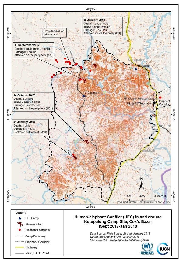
Survey Report
                               on
     Elephant Movement, Human-Elephant Conflict Situation,
          and Possible Intervention Sites in and around
                Kutupalong Camp, Cox’s Bazar

           [Survey Reporting Period: 21 January to 13 February 2018]

‘Biodiversity Conflict Mitigation around the Refugee Camp of Cox’s Bazar District’
                                       Project

               Implemented by: IUCN Bangladesh Country Office

                                PREPARED BY

                       IUCN Bangladesh Country Office
                      House B-138 (Level 5 & 6), Road 22
                        Mohakhali DOHS, Dhaka 1206
                      Phone: +8802 48810194, 48810195
                            Fax: +8802 48810197
                        Web: www.iucn.org/bangladesh

                               22 February 2018

                                                                            Page | 2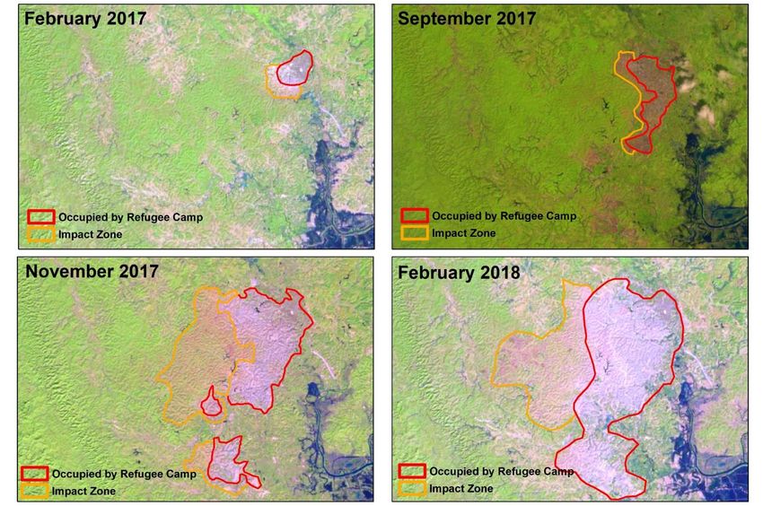
IUCN Bangladesh, with support from UNHCR, started a project entitled ‘Biodiversity Conflict Mitigation
around the Refugee Camp of Cox’s Bazar District’ with a view to minimize the human-elephant conflicts
in and around the Kutupalong Camp. At the project inception, IUCN Bangladesh had meetings with all
concerned government agencies, including Refugee Relief and Repatriation Commissioner (RRRC),
Deputy Commissioner of Cox’s Bazar, and Bangladesh Forest Department. It started field work after
receiving necessary authorization from the RRRC. During 21 January−13 February 2018, IUCN
Bangladesh engaged a trained elephant survey team to find out the elephant presence and population
size, recent human-elephant conflict situation, and possible intervention spots in and around the Camp
in Ukhia, Cox’s Bazar.

IUCN team surveyed approximately 70 square kilometers of bare hills around the camp and completed
transect walk of around 240 kilometers. A total of 160 elephant dung piles and 630 elephant foot-print
points of different ages were recorded around the Camp area and were mapped. The survey revealed
that elephant movement was frequent around Camp area, with highest concentration all along the west
boundary. Foot-print points were also found on the eastern side of the Camp. As per the ‘Dung Count
Method’, the estimated mean elephant number is 38 (range 31 to 45) in the five Forest Ranges (on the
west and south-west of the Camp) of the Cox’s Bazar South Forest Division.

Based on the elephant dung distribution and intensity, a total of possible 56 spots are identified to install
watch-towers. There is a need for forming 25 Elephant Response Teams (ERTs) and build their capacity
to guard the Camp. It was realized that trip alarm may not be useful as an elephant deterrent tool given
high human activities around the Camp, adjacent hills, and forest areas.

The survey indicated that the Camp is highly exposed with a larger number of open points through
which elephants could enter into the Camp. The hills around the Camp are now barren due to high rate
of deforestation. There are high risk of elephant encounter or exposure in the coming days unless
immediate mitigation measures are taken and long-term measures are planned and executed.

                                                                                                   Page | 3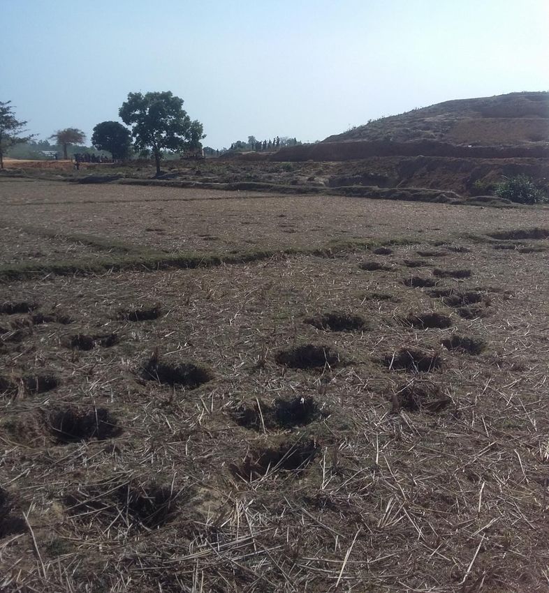
Project title: Biodiversity Conflict Mitigation around the Refugee Camp of Cox’s Bazar District

Location: Cox’s Bazar, Bangladesh

Project duration: January−December 2018

Project background: As of January 2018, Bangladesh hosts almost one million forcibly
displaced persons from Myanmar. The speed and scale of the influx following the violence in
Rakhine State, which began on 25 August 2017, has resulted in a critical humanitarian
emergency. Displaced people who arrived in Bangladesh came with very few possessions
and have been staying in several camps in Cox’s Bazar district in very congested condition.
To fulfill their basic needs, like food, shelter, and income generation, they are using resources
from the adjacent forests. This is resulting in a significant impact on the forest, biodiversity and
forest resources of that area.

Kutupalong of Ukhia, Cox’s Bazar, where the largest refugee camp is now established, is well
known for the important habitat corridor of Asian Elephants and is an important forest area
frequently used by wild elephants. It is also used as migration route of elephants from
Myanmar to Bangladesh and vice versa to cover food and shelter. Behaviourally, elephants
always follow their traditional routes and corridors for regular movement. If they find any
obstacles within it, they try to break it. As a consequence of that, human-elephant conflicts
have already happened on the edge of the refugee camp in Ukhia, causing several human
deaths since September 2017. The human-elephant conflict mitigation is therefore an urgent
issue requiring immediate resolution. Building on IUCN Bangladesh’s experiences on similar
conflict mitigation, UNHCR and IUCN have agreed to work together to minimize human-
elephant conflict in and around the Kutupalong camp area of Cox’s Bazar.

                                                                                          Page | 4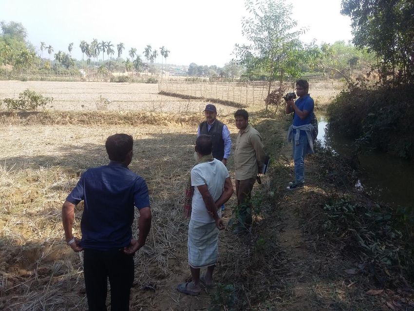
Objectives of the project: The project will address two specific problems: 1) the human-
elephant conflict, and 2) community awareness in and around the refugee camp in Cox’s
Bazar. To make any human-elephant conflict mitigation measures effective and sustainable,
it is important to improve the overall degraded forest area through long-term and large-scale
reforestation. Any such long-term initiative is currently lacking among the on-going initiatives.
To address these issues, the project is built around two specific objectives:

   a)   To implement human-elephant conflict mitigation measures with the refugee and host
        communities; and

   b)   To raise environmental awareness among refugee and host communities and to
        conduct advocacy with other stakeholders for overall, long-term environmental
        improvement of the camp area and beyond.

Activities: The main activities of this project are:

   o    Consultation with the relevant stakeholders, namely refugee and host communities,
        Refugee Relief and Repatriation Commissioner’s Office (RRRC), Bangladesh Forest
        Department, law enforcement agencies, other UN agencies, NGOs and INGOs, to
        select potentially affected communities to implement mitigation measures;
   o    Marking of elephant routes and corridors to install the road-signs and to inform the
        local communities and stakeholders to avoid the marked areas;
   o    Initiate human-elephant conflict mitigation options, like formation and capacity
        development of Elephant Response Teams (ERTs); providing equipment to ERTs to
        divert in-coming elephants; and setting up elephant deterrent tools (e.g. trip alarms
        and watch-towers); and
   o    Organize awareness raising and advocacy programmes on the importance of
        biodiversity, forests and related issues to sensitize agencies, stakeholders, and
        institutions.
Expected results: The project envisages impacts at two levels. First, a significant portion of
the refugees living on the edge of the camp and the local host communities living around the
camp area will be protected from potential elephant attacks by using proven methods and
technologies. Second, by capturing the project learning and by networking with other agencies
working in this region, the project experience could be scaled up, in the camp area and
beyond. This would contribute to development of a long-term programme that would lead
towards overall environmental improvement of Cox’s Bazar − an outstanding region bestowed
with marine, coastal and hill ecosystems – and its resilient people.

Donor: United Nations High Commissioner for Refugees (UNHCR)

Implementing agency: IUCN Bangladesh Country Office

                                                                                        Page | 5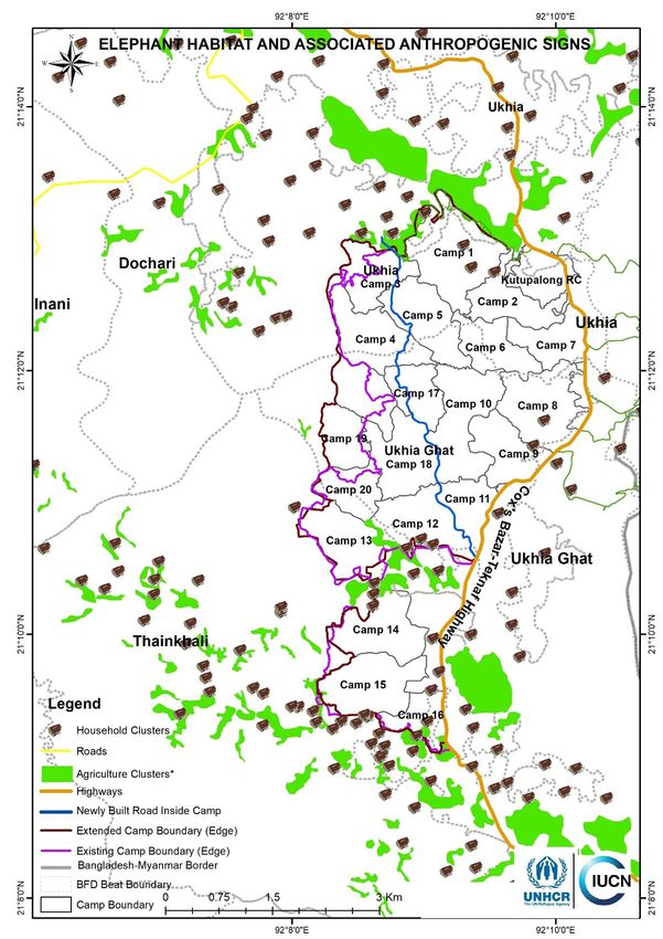
HUMAN-ELEPHANT CONFLICT SITUATION
The extended refugee camp in Kutupalong, Ukhia has been established within the Reserved
Forest areas of Cox’s Bazar South Forest Division − a core habitat of the Critically Endangered
Asian Elephant in Bangladesh. The refugee camp is also falls within an active elephant
corridor (elephant always use this part to migrate from one forest to other).. The previous
situation of this area is shown in Map 1. This map was prepared by IUCN Bangladesh and
Bangladesh Forest Department back in 2016 during a country-wide survey on estimating
Bangladesh’s elephant population and mapping their movement paths and corridors.

It is obvious that the forcibly displaced Myanmar citizens or the refugee communities living on
the edge of Kutupalong Camp and the local people living close to the elephant movement
routes and corridors are the most vulnerable to elephant encounters and attacks. Recently, a
number of human-elephant conflict incidences have happened close to the Camp as well as
inside the Camp causing human casualties. Nine people were killed, including children and
elderly people from mid-September 2017 to 21 January 2018.

To capture the details of those incidences, IUCN Bangladesh surveyed the Kutupalong Camp
area during 21−24 January 2018. IUCN team started the reconnaissance survey on 21
January 2018 along with local Forest Department staff and local guides to get familiar with the
field situation and to understand community perceptions. The team also met the RRRC (19
January), UNHCR officials (20 January), and Deputy Commissioner of Cox’s Bazar (22
January), and discussed the project, inter-agency coordination, RRRC permission, and initial
field activities, and also sought necessary support and advice from them on implementing the
project. A number of preliminary discussions were held with the Bangladesh Forest
Department officials at Forest Division (Cox’s Bazar) and Forest Range (Ukhia) levels on the
field operations. IUCN team interviewed the family members and neighbours of the victims,

                                                                                      Page | 6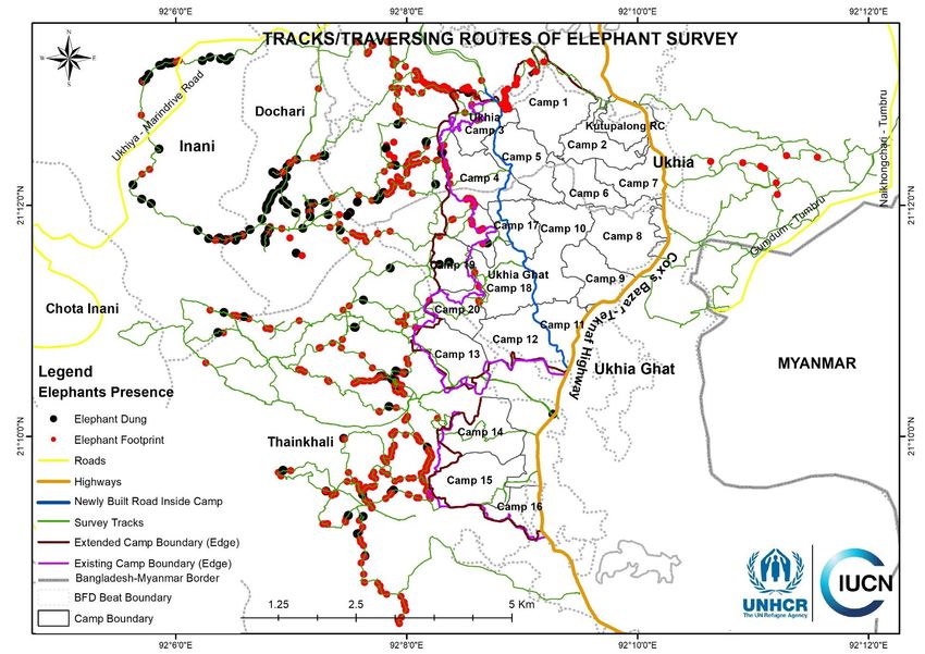
families whose houses were damaged by the elephant, and officials of Bangladesh Forest
Department, CiCs, UNHCR and other agencies working in the Camp. IUCN started field work
after receiving necessary authorization from the RRRC.

The human-elephant conflict incidences in and around this Camp from September 2017 to
January 2018 are shown in Map 2. More detailed surveys were undertaken to understand the
elephant movement in and round the Camp area.

                                          New
                                          camp

Map 1: Elephant movement routes and corridors fall within the expanded Kutupalong Camp area,
Ukhia, Cox’s Bazar. [Based on Motaleb, M.A., Ahmed, M.S., Islam, H. and Haque, M.A., 2016. Atlas:
Elephant Routes and Corridors in Bangladesh. IUCN, International union for Conservation of Nature,
Bangladesh Country Office, Dhaka, Bangladesh, xi+103]

                                                                                         Page | 7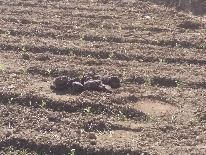
Map 2: Human-elephant conflict incidences around the Kutupalong Camp area since September 2017.
(Data from IUCN Bangladesh’s field survey conducted during 21−24 January 2018)

                                                                                      Page | 8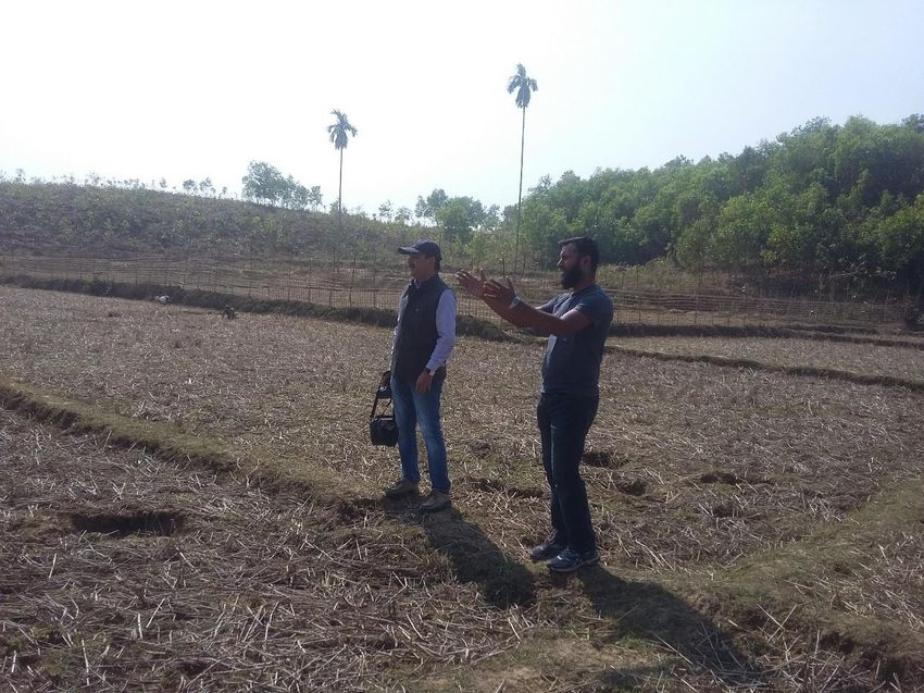
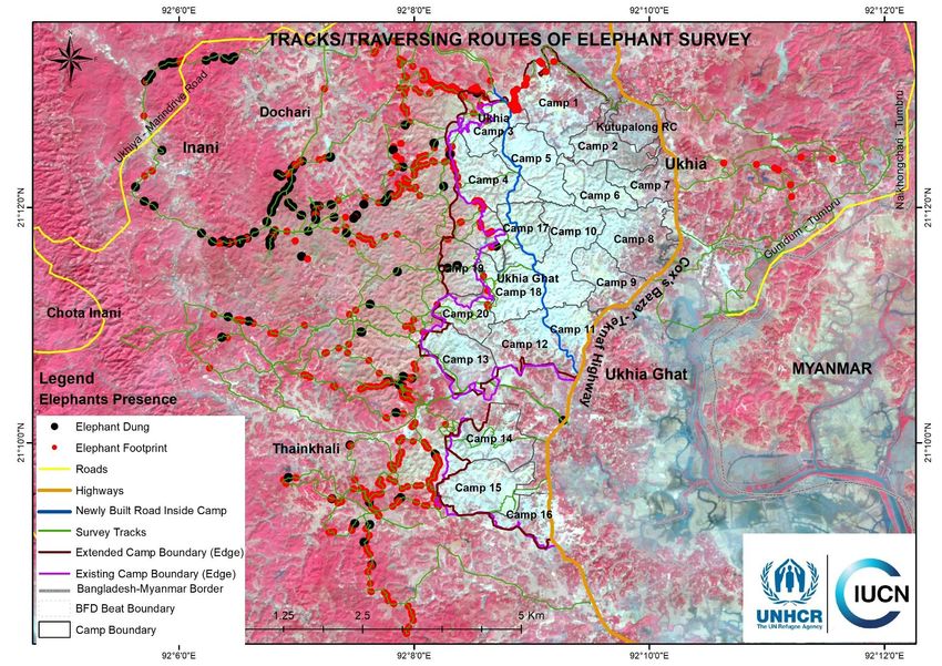
ELEPHANT MOVEMENT IN AND AROUND THE CAMP

The initial survey of 21 January indicated that the following issues needed to be understood
before starting the implementation of human-elephant conflict mitigation interventions on the
ground, with the refugees and for the refugees.

   1. What are elephant movement patterns in and around the Kutupalong Camp?
   2. Where are the potential entry points of elephants on the Camp boundary?
   3. Which sites are vulnerable to elephant attack?
   4. How many elephants got stranded on the either side of the Camp?
   5. Where should the Elephant Response Teams (ERTs) be formed and how many?
   6. Where will the watch-towers and trip-alarms be installed and how many?
   7. What are the past human-elephant conflict experience of Rohingya people in Myanmar
      and their traditional mitigation methods? and
   8. What are people’s perceptions towards elephant conservation and human-elephant
      conflict mitigation?

 Consultation with the refugee community about the elephant attack near Camp 18. © IUCN/
 M. A. Motaleb

                                                                                    Page | 9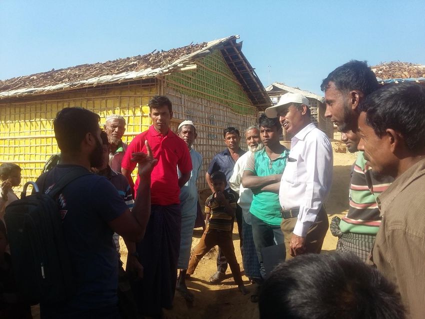
The project team collected data and information through structured questionnaires. Two
questionnaires have been developed (Annexes 1 and 2) to find out the answers to the above
questions.

Field Survey and Map Preparation: A total of seven teams were engaged to conduct the
elephant survey starting on 31 January 2018. Each team consisted of two surveyors and a
local guide, who had the knowledge about the elephants and their movement. Initially, the
edge of the camp were surveyed to find out any signs and movement of elephants. Any types
of elephant signs (e.g. foot-prints, dungs, and broken trees) were recorded on GPS. The
plotted GPS data of elephant sign revealed the elephant movement routes or entry points to
the Camp. From those points, the survey team followed the elephant signs towards the nearest
Inani Forest to map out the elephant movement routes.

Two important pieces of evidence or features that prove the presence of elephant are
elephant’s foot-prints and dung piles. IUCN survey teams surveyed for these proofs to
understand the intensity of the elephant movement in and around the refugee camp in
Kutupalong. The survey teams conducted GPS-GIS-based survey along with participatory GIS
(PGIS) technique to accurately locate the foot-prints and dung piles of elephants. Based on
the GPS points, a number of maps were produced using ARC-GIS.

 Consultation with the refugee community to know about the elephant attack of September
 2017 near Camp 3. © IUCN / Tarik Kabir

                                                                                  Page | 10
HEC Mitigation Spot Identification: Based on the plotted survey data and generated maps,
a team of 3 persons conducted survey along the edge of the camp to find out the spots to
install human-elephant conflict (HEC) mitigation measures, like the watch-towers and trip-
alarms, and also to form the Elephant Response Teams (ERTs).
Elephant Number Estimation: The number of elephants blocked on either side of the camp
was estimated by using the globally standard Dung Count Method. The elephant number was
calculated by using stochastic simulation program GAJAHA 2.01.
Land Use Change and Host Community Locations: By analyzing the GIS and RS images,
the land use change over time (from February 2017 to February 2018), the locations of the
host community villages, and agricultural land were mapped.
Fresh elephant dung found near Camp 3. © IUCN / M. A. Motaleb
1 IUCN Bangladesh, 2016. Status of Asian Elephants in Bangladesh. IUCN, International Union for Conservation
of Nature, Bangladesh Country Office, Dhaka, Bangladesh. pp xii + 102.
https://portals.iucn.org/library/sites/library/files/documents/2016-085.pdf
Page | 11Major Findings
Initially, an elephant entry point was identified close to Camp 3 based on the availability of
elephant dung piles and foot-prints. Subsequently, during a field visit on 23 January, IUCN
Bangladesh team and Dr. Sandeep Kumar Tiwari, an expert from IUCN Species Survival
Commission (SSC)’s Asian Elephant Specialist Group (AESG), came to the conclusion that
since elephants’ frequently used routes and corridor had been blocked by the expansion of
the Camp, the animals could be moving move around the camp along its border. To prove this
hypothesis, IUCN’s field survey started on 31 January 2018, engaging a team of 14 staff and
volunteers. The survey team was duly oriented about the field situation, the Camp condition,
Elephant foot-prints close to the Camp 3 © IUCN/ M. A. Motaleb
Page | 12and were made aware of other precautions that to be taken while interacting with the refugee
individuals and families.
Elephant signs
The survey team completed survey of approximately 70 square kilometers of bare hills around
the refugee Camp and completed a total of 240 kilometers of transect walk along 55 tracks in
search of elephant foot-prints and dung piles. The team collected 963 feature points. Among
those, 160 points were dung piles at different decomposition stages and 630 points were of
elephant foot-prints of different ages and times. The rest of the feature points shown on the
maps represent basic land and forest cover, which are also crucial to understand elephant
movement. Most of the elephant signs were found on the western side of the Camp.
A few signs of elephant movement were also found on the eastern side of the Camp. The
frequency of elephant movement in the eastern boarder of the Camp may increase during the
coming pre-monsoon and monsoon season. It should be noted that no past research data is
available on the elephant migration pattern in different seasons. This knowledge gap needs to
be filled with long-term research in future. The IUCN team will continue monitor elephant
movement around the Camp.
Elephant presence and entry points
Based on the survey data, maps were generated to present an analysis of the situation, and
to guide the human-elephant conflict mitigation activities on the ground. The Maps 3 and 4
show the distribution and intensity of elephant presence in and around the camp, without and
with the survey tracks, respectively. The background satellite image is given in Map 5 showing
the landscape of the same area. Surveys and maps revealed that elephant movement was
frequent along the north-western and western boarder of the Camp, specifically Camps 1, 3,
4, 17, 19 (currently not inhabited), 18, 20, 13, 14, 15, and 16.
The survey revealed a number of points through which elephants could enter into the Camp,
as the whole area is now barren due to high rate of deforestation. Such exposure to elephant
interaction and elephant entry are expected to increase in the coming days.
Based on the presence of elephant signs and the possible entry points for elephants, the
priority sites (High, Medium and Low) were identified to start the intervention (Map 6).
Proposed locations for watch-towers
The survey identified a total of 56 possible spots along the Camp boundary where human-
elephant conflict mitigation measures, like installing watch-towers, need to be taken (Map 7)
in the western side of the Camp. The total number of watch-towers may need to be increased,
if the Camp is expanded to new areas and if migration starts from the eastern side.
Possible locations for Elephant Response Teams (ERTs)
Based on elephant intensity, the survey suggested to form 25 ERTs who will be training and
facilitated to be in-charge of protecting the north-western and western sides of the Camp. The
total number of ERTs may need to be increased, if the Camp is expanded to new areas and
of eastern side also needs to be protected.
Page | 13.
Understanding the elephant movement close to the Camp 3 by elephant expert and
IUCN team © IUCN/ Tarik Kabir and M. A. Motaleb
Page | 14Map 3: Elephant presence around Kutupalong Camp in Cox’s Bazar, based on elephant signs (foot-prints and dung piles). (Data from IUCN
Bangladesh’s field survey conducted during 31 January-10 February 2018 and maps provided by UNHCR)
Page | 15Map 4: Elephant presence, along with traversing routes, around Kutupalong Camp in Cox’s Bazar, based on elephant signs - foot-prints and dung
piles. (Data from IUCN Bangladesh’s field survey conducted during 31 January-10 February 2018 and maps provided by UNHCR)
Page | 16Map 5: Elephant presence, against the landscape features, around Kutupalong Camp in Cox’s Bazar, based on elephant signs - foot-prints and
dung piles). (Data from IUCN Bangladesh’s field survey conducted during 31 January-10 February 2018 and maps provided by UNHCR)
Page | 17Map 6: Priority sites to start interventions (i.e. watch-tower and ERTs), based on elephant signs (i.e.
foot-prints and dung piles). (Data from IUCN Bangladesh’s field survey conducted during 31
January−10 February 2018 and maps provided by UNHCR)
Page | 18Map 7: Proposed locations of watch-towers around Kutupalong Camp in Cox’s Bazar, based on
elephant signs (i.e. foot-prints and dung piles). (Data from IUCN Bangladesh’s field survey conducted
during 31 January−10 February 2018 and maps provided by UNHCR)
Page | 19Status of elephants around the Camp
IUCN deployed a team to find out the number of elephants in the five Forest Ranges of Cox’s
Bazar South Forest Division on the north-west, west, and south-west sides of the Camp.
Based on globally accepted ‘Dung Count Method’ of Asian Elephant population estimation,
the elephant number was calculated2. It was found that the current mean elephant number in
five Forest Ranges that use this corridor is 38, which ranges from 31 to 45. In 2015, the mean
number was 35, which ranged from 28 to 42. Table 1 compares the forest range-wise elephant
numbers for the year 2018 and 2015. The little higher number of elephant in 2018 than 2015
might be due to an increase in elephant population by birth or due to entrapment of elephants
on the western side of Kutupalong Camp because of the Camp’s expansion since August
2017 on the elephant corridor.
Table 1: Status of Elephants in five Forest Ranges of Cox’s Bazar South Forest Division on the
north-west, west and south-west sides of the Kutupalong Camp, Ukhia, Cox’s Bazar.
Elephant Number in 2018* Elephant Number in 2015**
Forest Total Area
Range (sq. km.) Lower Upper Lower Upper
Mean Mean
Limit Limit Limit Limit
Ukhia 72.76 0 0 0 7 5 8
Inani 65.8 18 16 21 12 10 14
Teknaf
47.5 10 8 12 7 6 8
Sadar
Shilkhali 29.42 7 5 8 6 5 7
Whykhong 50.97 3 2 4 3 2 5
Total
38 31 45 28 42
35
* Based upon the field survey by IUCN Bangladesh team during 10−13 February 2018 under the present UNHCR-
IUCN project.
** Based upon the elephant status survey data collected by IUCN Bangladesh under the ‘Strengthening Regional
Cooperation for Wildlife Protection (SRCWP) Project’ during dry season. Details on this project can be found on:
https://portals.iucn.org/library/sites/library/files/documents/2016-085.pdf
Distribution of host communities’ settlements and agricultural fields
The cluster of households and the agricultural fields belonging to the host communities were
mapped to measure their vulnerability to possible elephant attacks (Map 8). The map showed
a significant number of host communities are currently inhabiting close to the Camp and are
exposed to elephant attacks as elephant cannot pass the Camp through elephant corridor.
This information can help to involve host communities in forming ERTs and installing watch-
towers, thus taking part in effective human-elephant conflict mitigation in this area.
Land cover change (February 2017−February 2018)
Land cover change due to land use from February 2017 to February 2018 was analyzed and
mapped by using the Remote Sensing analysis (Map 9). This show a significant change in
land cover in and around the Camp area over the past six months.
2 IUCN Bangladesh, 2016. Status of Asian Elephants in Bangladesh. IUCN, International Union for Conservation
of Nature, Bangladesh Country Office, Dhaka, Bangladesh. pp xii + 102.
https://portals.iucn.org/library/sites/library/files/documents/2016-085.pdf
Page | 20Map 8: Locations of host communities’ settlements and agricultural fields around Kutupalong Camp in
Cox’s Bazar. (Based on data from GIS and RS image analyses and maps provided by UNHCR)
Page | 21Map 9: Land cover change between February 2017 and February 2018 around Kutupalong Camp area, Ukhia, Cox’s Bazar. [Based on data from RS and GIS
map analyses and field observations (February 2018)]
Page | 22Elephants usually move in groups through their routes and corridors in search of food and
shelter. The Kutupalong Refugee Camp is situated within a very busy elephant corridor, which
is now blocked with tens and thousands of temporary make-shift refugee houses and other
structures. The present survey results show extensive presence of elephants around the
Camp area, which is expected to increase in the coming days since this area falls under
migration route and corridor of elephants between Bangladesh-Myanmar.
Based on the distribution and intensity of elephant dung piles, the proposed number and
locations of watch-towers, and Elephant Response Teams (ERTs) were determined and
shared in this report. It was, however, found that the Camp area would be extended on some
camp sites (e.g. Camps 3, 17 and 19), which will increase the probability of human-elephant
conflict. It is important to consider the current elephant movement patterns before taking final
decision to expand the Camp area. Necessary precaution and mitigation measures must be
taken to protect the refugees before populating Camps 3, 17 and 19, for example. Accordingly,
the final number and locations of watch-towers and Elephant Response Teams (ERTs) will
vary depending on the plan for Camp expansion. The survey results also indicated that trip
alarm may not be a useful elephant deterrent tool due to high human activities around the Camp,
on the adjacent hills, and in the forest areas.
While surveying for elephant presence and population estimation, IUCN survey team found
that due to regular earth-work around the Camp and the use of elephant dung as cooking fuel
by the refugees, the elephant signs (i.e. foot-prints and dung piles) were destroyed/damaged.
Such loss of elephant dungs might have affected the estimation of elephant numbers in this
Page | 23highly disturbed area, since such estimation in based upon globally acceptable ‘Dung Count
Method’.
Based on the current elephant presence/movement around the Kutupalong Camp, on the
estimated elephant number around this area (five ranges of Cox’s Bazar South Forest
Division), and on spot identification for possible mitigation measures (i.e. ERTs and watch-
towers), initial field interventions were undertaken by involving all concerned stakeholders.
The scale of the operations will be increased immediately after final consultation with CiCs,
Bangladesh Forest Department officials, and representatives of UNHCR, IOM and other
pertinent agencies. Implementation of human-elephant mitigation measures also strongly
considers the social structure of the refugee community, the existing information
communication channels between agencies and refugees, and UNHCR’s policy to work with
refugees.
The survey results clearly indicate that immediate, short-term mitigation measures are needed
in and around the Camp area to tackle the prevailing human-elephant conflict. The incidences
of 22 February 2018 morning, where a couple of young persons died, a woman got wounded,
and many houses were damaged in a number of Zones of the Camp, alarmingly highlight the
gravity of this situation. Our team is working very closely with the officials of Bangladesh Forest
Department, CiCs and the refugees to respond to this situation.
We have also been actively discussing this human-elephant conflict issue with the national
and international elephant experts of IUCN to capitalize on our global network pulling
experiences from similar situation elsewhere. A few common short-term and long-term
strategies have emerged from these expert discussions. Based on these as well as our
extensive field survey, we have already started to implement some short-term measures, like
forming Elephant Response Teams (ERTs) and installing watch-towers in suitable spots.
In addition immediate solutions, like to ERTs and watch-towers, we also need to consider
long-term mitigation measures, like habitat management and improvement, stopping firewood
collection from the adjacent forests and elephant corridor, and conducting research on
elephant movement and migration pattern through radio collaring. It is important that all
stakeholders put their acts together to implement practical solutions to save human lives as
well as to protect Critically Endangered Asian Elephants.
Page | 24Annex 1: Raccee Survey Transect (RST) Date Sheet
Forest Division/Range/Beat:
Upazila/Union/Mouza:
Enumerator:
Date: Number of RST:
Start time: Start waypoint:
End time: End waypoint:
GPS Elephant dung-pile Elephant foot- Elephant herd Water body
Location print
(Waypoint) Number Decay Dung- Perpendicular Old in Foot- Number of Male Female Calf Stream Waterhole
of boli stage pile distance (m) days print elephants
location location
Page | 25Annex 2: Questionnaire to conduct Focused Group Discussion (FGD)
Name of the Camp: Block: Date:
GPS location:
Sl Questions Information/suggestions
no.
1 Did you see elephant inside or outside the
camp/block?
2 If, yes, when and where (Date, time & place)?
Collect GPS location of the last time
encounter
3 Frequency of observing elephants and
number of the elephants (e.g. days, weeks)
4 What have you done to deter elephants?
When you see them (timing)?
5 Possible entry points of the elephants of your
area/block and GPS location of the entry
points
6 What is the present situation of HEC at your
camp/block (e.g. house damage, human
injury, human killed, elephant killed, etc.)
7 Status of the elephant encounter between
early days of the settlement and the present
days
8 Have you ever faced HEC in Myanmar?
How frequent?
9 What were traditional HEC mitigation
measures in Myanmar?
10 What are your thoughts and opinions to
mitigate HEC in your camp/block?
11 IUCN and UNHCR is implementing HEC
mitigation project. What do you think about it?
12 Expectations from the project
13 Others
FGD Conducted by:
Contact persons (CiC, Majhi and local people):
Page | 26FGD attendance
Male:
Female:
Enthusiastic persons to work in HEC:
Name Contact Number Camp /Block/Address
Page | 27You can also read