Technical Review of Alternative Routes between Loganholme and Stapylton - Coomera Connector March 2021
←
→
Page content transcription
If your browser does not render page correctly, please read the page content below

Technical Review of Alternative Routes
between Loganholme and Stapylton
Coomera Connector
March 2021
Document control options

Prepared by         Robert G Higgins PSM
Title               Assessment Lead
District & Region   South Coast Region
Branch & Division   Program Delivery and Operations Branch, Infrastructure Management and Delivery
                    Division
Project/program     M1 Pacific Motorway (Loganholme – Nerang) and Coomera Connector
Project number      697915
Project location    Coomera Connector corridor – Loganholme to Stapylton
Status              Final
DMS ref. no.        500/00295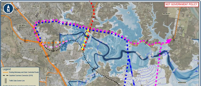
Contents
Executive summary 5
1. Introduction 11
1.1 Background 11
1.2 Purpose of technical review 12
2. Key features of alignments 14
2.1 Gazetted Coomera Connector 14
2.1.1 Background history 14
2.1.2 Key features 14
2.2 Alternative routes suggested by community 15
2.2.1 Community Submissions 15
2.2.2 Key features of alternative routes 18
3. Technical Assessment 21
3.1 Coomera Connector as a future transport corridor 21
3.2 Assessment approach 21
3.3 Assessment of major deviations of gazetted Coomera Connector corridor 24
3.3.1 Detailed multi-criteria assessment 24
3.3.2 Summary of multi-criteria assessment outcome 30
3.4 Assessment of minor deviations of gazetted Coomera Connector corridor 32
3.4.1 Detailed multi-criteria assessment 32
3.4.2 Summary of multi-criteria assessment outcome 33
4. Summary 34
Appendices 36
Table of Figures
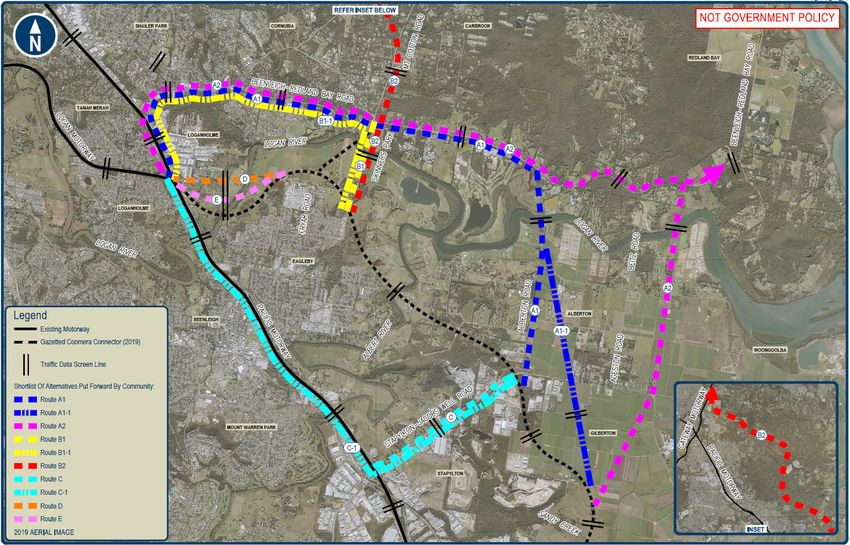
Figure 1: Proposed alternative alignments 5
Figure 2: Gazetted Coomera Connector corridor and study area 11
Figure 3: Alternative routes and gazetted Coomera Connector corridor 17
Figure 4: Logan River 1% AEP flooding map (TMR 2018) 20
Figure 5: Extent of urban footprint 26
Table of Tables
Table 1: Daily traffic volume (AWDT) change relative to 2041 Base Case 7
Table 2: Direct Property Impacts 8
Table 3: Cost comparison of alternative routes 9
Table 4: Overall assessment summary of alterantive routes compared to gazetted Coomera Connector
10
Table 5: Summary of alternative routes 16
Technical Review of Alternative Routes between Loganholme and Stapylton -3-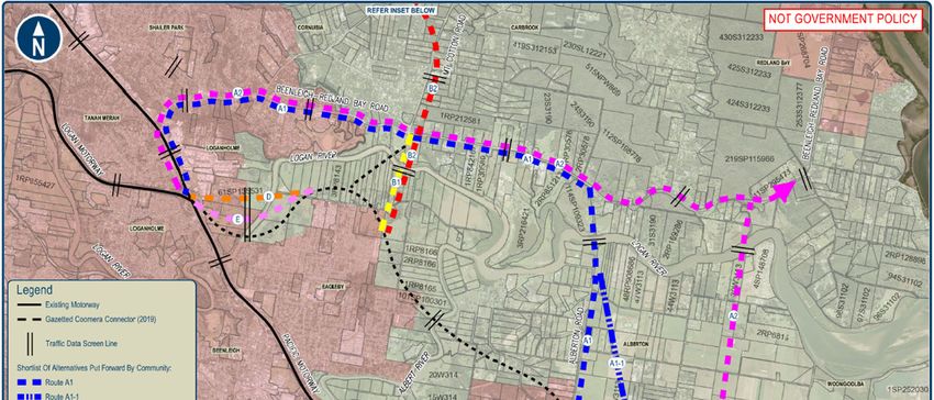
Table 6: Key selection criteria                                                           22
Table 7: Scoring scale for value element                                                  24
Table 8: Daily traffic volume (AWDT) change relative to 2041 Base Case                    25
Table 9: Direct Property Impacts                                                          26
Table 10: Estimated Cost of Routes for the Coomera Connector                              28
Table 11: Estimated Cost of Upgrading the M1                                              29
Table 12: Estimated Project Cost                                                          29
Table 13: Outcome of MCA - major deviations of the gazetted Coomera Connector corridor    30
Table 14: Outcome of MCA - minor deviations of the gazetted Coomera Connector corridor    33
Table 15: Overall assessment summary of alterantive routes compared to gazetted Coomera
Connector                                                                                 34

 Technical Review of Alternative Routes between Loganholme and Stapylton                       -4-

Executive summary
The Department of Transport and Main Roads (TMR) is progressing the planning for the M1 Pacific
Motorway between Loganholme and Nerang including the Coomera Connector. In October 2019 the Premier
of Queensland announced a Business Case would be progressed for Stage 1 of the Coomera Connector
between Coomera and Nerang with Stage 2 between Loganholme and Coomera a future stage.
In November 2019, TMR undertook a community consultation program for the full length of the Coomera
Connector and received feedback from the community, including a number of alternative alignments for the
northern section of Coomera Connector corridor.
This report is focussed on a Technical Review of the alternative alignments provided by the community
between Loganholme and Stapylton. The alternative routes are shown in the figure below.
Figure 1: Proposed alternative alignments
The Technical Review will be carried out in two phases:
1. The initial phase being an assessment of the technical merits and feasibility of the alternative routes
suggested by the community compared to the gazetted route.
2. The scope of the next phase depends on findings of this initial phase and further consideration by
TMR.
The Technical Review divided the alternative routes into two categories:
Major deviations: Routes A1, A1-1, A2, B1, B2 and C
Minor deviations: Routes D and E are minor refinements to the gazetted route in the Eagleby area to
reduce impacts to the human and natural environment.
To allow a meaningful comparison between all suggested routes and the gazetted Coomera Connector
corridor, the following amendments were made to suggested Routes B1 and C:
Technical Review of Alternative Routes between Loganholme and Stapylton -5-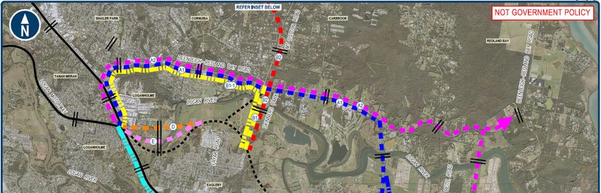
Route B1 was amended to Route B1-1 to include the upgrading of the Beenleigh-Redland Bay Road
from Mt Cotton Road to the Logan Motorway which would be required to meet the 2041 travel demand
forecasts; and
Route C was amended to Route C-1 to include the upgrading of the M1 Motorway between Stapylton
and Logan Motorway which would be required, also to meet the 2041 travel demand forecasts.
A multi criteria analysis was developed to assess the alternative routes against the gazetted Coomera
Connector corridor. The criteria selected for comparing the routes were:
1. functionality
2. impacts on the human environment
3. impacts on the natural environment
4. estimated cost.
Inputs for the Technical Review was collected from previous investigations, advice from technical experts,
site visits, and community feedback provided from the community consultation program in late 2019.
Summary of findings
This review has determined the gazetted Coomera Connector corridor:
provides the best overall outcome compared to the major deviation alternative alignments. The amended
Route B1-1 was the next best, followed by Routes A1, A1-1, A2 with amended Route C-1 ranked last
provides the highest level of congestion relief at the Albert and Logan Rivers
impacts the lowest number of properties between Loganholme and Stapylton
impacts the environment that will be mitigated through design and construction, however avoids matters
of national environmental significance that alternative alignments impact north of the Logan River
provides the best value for money.
It should be noted that some alternative routes provided by the community were incomplete and did not
provide a comparable solution. These options were adjusted to include additional upgrades that would be
required to the adjacent road network with considerable property impacts to facilitate changes in traffic
including:
upgrading Beenleigh-Redland Bay Road to 6 lanes to accommodate increased traffic between the
proposed alternative Coomera Connector route and the M1 at Loganholme for routes A1-1, B1-1 and A2
upgrading Stapylton Jacobs Well Road from the Coomera Connector gazetted corridor at Stapylton to
the M1 at Yatala (Exit 38) to accommodate increased traffic betwwn Coomera Connector and the M1 for
route C-1
upgrading the M1 between Logan Motorway and Yatala (Exit 38) to accommodate increased traffic on
the M1 as the Coomera Connector ends at Stapylton for route C-1.
Route B2 (connecting to the Gateway Motorway) is not supported due to the significant impact the route
would have on the critically important koala habitat north of Beenleigh Redland Bay Road, listed under the
Queensland Government’s (draft) SEQ Koala Conservation Strategy and is not consistent with the current
master plan and approved funding for upgrading the M1 north of Loganholme to Eight Mile Plains.
This review has assessed the relative technical merits of the alternative routes compared to the gazetted
Coomera Connector corridor. The assessment has determined the gazetted Coomera Connector corridor is
the best alignment for the Coomera Connector between Loganholme and Stapylton to achieve the necessary
transport outcomes required to meet projected demand in 2041, whilst considering the impacts to the human
and natural environment and cost.
Technical Review of Alternative Routes between Loganholme and Stapylton -6-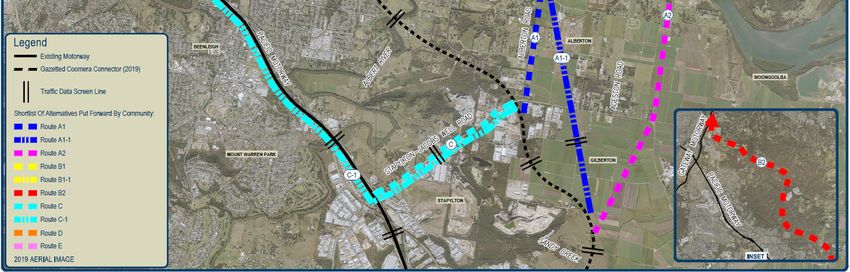
Assessment summary of major deviations
Routes A1, A1-1, A2, B1, B2 and C
Functionality
Travelling demand modelling to 2041 found:
The gazetted Coomera Connector corridor reduced the 2041 forecast daily volumes on the M1 at the
Logan River by 45,000 vehicles while the next best alternative (Route B1-1) offered a reduction of
31,000 vehicles. Reducing traffic congestion on the M1 is a key objective of the Coomera Connector
corridor
The gazetted Coomera Connector has the added benefit of reducing daily volumes on the Beenleigh-
Redland Bay Road by 16,800 vehicles (California Ck) and would not need further upgrade on this basis.
The other routes (except Route C-1) require a significant upgrade of the Beenleigh- Redland Bay Road,
to meet the forecast travel demands
Route C-1 requires significant upgrading of the M1 to meet the future travel demand forecasts, noting the
route still requires all traffic between Stapylton and Loganholme to use the M1 corridor with no
alternative provided.
Table 1: Daily traffic volume (AWDT) change relative to 2041 Base Case
Change in AWDT Relative to Base Case
2016 2041 Route
Locations Coomera Route Route Route Route Route
(AWDT) (AWDT) C&
Connector A1 A1 -1 A2 B1 B1-1
C-1
M1 Motorway
4. M1 at Logan River 181,800 256,500 -45,000 -25,300 -26,300 -17,900 -19,900 -31,000 6,200
5. M1 at Albert River 166,400 234,000 -24,300 -6,200 -7,400 -500 -200 -12,000 24,000
Coomera Connector
7. CC at Logan River - 62,600 65,200 - - - -
8. CC at Logan River - - - 55,900 - - -
9. CC at Logan River - - - - 54,000 67,900 -
10. CC at Logan River 67,000 - - - - - -
11. CC at Albert River 83,800 - - - 54,000 67,900 -
Key supporting roads
18. Beenleigh-Redland
22,300 29,500 -16,800 15,000 16,700 8,700 -2,300 22,000 0
Bay Rd (California Ck)
19. Beenleigh-Redland
7,400 14,300 7,700 34,300 36,400 19,400 6,800 8,000 -200
Bay Rd (east of Stern)
22. Stapylton-Jacobs
6,600 12,800 7,700 12,200 12,400 20,700 6,800 7,900 -200
Well Rd
Note: Volumes are bidirectional. Positive sign (Blue colour-coding) represent the increase in volumes compared to the Base Case.
Negative sign (Green colour-coding) represent the decrease in volumes compared to the 2041 Base Case
It should also be noted the gazetted Coomera Connector corridor greatly improves accessibility and
functionality for the Eagleby community by having another access to the M1 and Logan Motorway and to the
Redland Bay area via Mount Cotton Road and Beenleigh Redland Bay Road.
Human Environment
All communities will experience some change in amenity impacts with a new road and this will vary from
route to route. The assessment found the gazetted Coomera Connector will create the least impact on the
human environment:
Technical Review of Alternative Routes between Loganholme and Stapylton -7-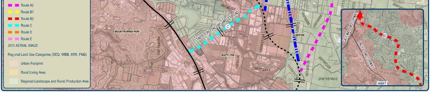
The gazetted Coomera Connector corridor (between Loganholme and Stapylton) is directly impacting
104 properties and 22 dwellings. The property impacts from alternative routes A1, A1-1, A2 and
Amended Route B1-1 are much greater with the property impacts 26% to 40% higher and dwelling
impacts 27% to 86% higher. The impacts from amended Route C-1 are much greater again because of
the need to upgrade the M1 to meet the forecast travel demand.
While the Eagleby community will experience community impacts from the gazetted Coomera Connector
corridor, the impacts will be much greater on the Cornubia and Loganholme communities due to the
increased traffic volumes.
The Eagleby community will have significantly improved accessibility as a result of the gazetted
Coomera Connector.
Table 2: Direct Property Impacts
Route
Nature of Direct Impacts Amended Amended
Coomera Route Route
Route A1 Route Route
Connector A1 -1 A2
B1-1 C-1
No. 104 138 137 146 131 394
Change (%) to
Properties Coomera 100% 133% 132% 140% 126% 379%
Connector
No. 22 33 28 41 38 >300
Dwellings Change (%) to
Coomera 100% 150% 127% 186% 173% >1360%
Connector
Natural Environment
All routes fall within the catchments of the Logan and Albert Rivers that contain natural environmental
values.
Amended Route C-1 created least impact of the all routes on the natural environment because it follows an
existing road network that is already disturbed. Amended route B1-1 was next best and slightly better than
the gazetted Coomera Connector corridor because it removed a second crossing of Logan River and
avoided the wetlands to the west of Wharf Road at Eagleby.
Routes A1, A1-1 and A2 are located further to the east of the gazetted Coomera Connector and traverse
more environmentally sensitive areas. Routes A1, A1-1 and A2 involve significant upgrading of the
Beenleigh- Redland Bay Road which is within the Koala Priority Areas.
Estimated Project Cost
To allow a meaningful assessment of the cost of the alternative routes compared to gazetted Coomera
Connector corridor:
Base Cost Estimates which have not been adjusted for risk and escalation were prepared, and
the cost of further upgrades of the M1 corridor to meet forecast travel demands has been added to both
the cost of Routes A1, A1-1, A2, Amended B1-1, Amended Route C-1 and the gazetted Coomera
Connector corridor.
As illustrated in Table 3 below, all alternative routes are a higher cost than the gazetted Coomera Connector
corridor. Alternative routes A1, A1-1, A2 and Amended Route B1-1 are 17% to 24% higher in cost, whilst
Amended Route C-1 is much higher again at 117% as this requires significant upgrades to the M1.
Technical Review of Alternative Routes between Loganholme and Stapylton -8-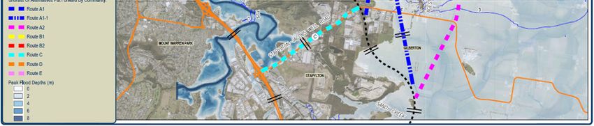
Table 3: Cost comparison of alternative routes
Description of Works and Change in Cost Compared to Coomera Connector
Base Cost Component
Amended
Coomera Route Route Route
Route Amended Route C-1
Connector A1 A1-1 A2
B1-1
Works to upgrade
Works required for the Coomera Connector between Loganholme Stapylton Jacobs Well
Coomera Connector
and Stapylton Road from Coomera
Connector to M1
Works required to upgrade the M1 including Auxiliary lanes,
interchange upgrades & smart motorway technologies from
Computer Rd to Logan Motorway
M1 Corridor Upgrades
New motorway of
express lanes and
collector distributor lanes
+ smart motorway
technologies from south
of Stapylton to Logan
Motorway
% Change 100% 117% 124% 124% 117% 217%
Assessment of minor deviations
Routes D and E
The minor deviations (Routes D and E) have slightly different crossings of the Logan River which shifts the
gazetted Coomera Connector corridor further away from the Eagleby community and further into the Logan
River floodplain. Both routes have lesser natural and human environmental impacts than the gazetted
Coomera Connector by:
traversing sections with less environmental values
replacing road embankment with bridging structure, and
moving away from the urban areas of Eagleby.
While Route D has a more direct connection to the Logan Motorway, the route has a significant impact on
Logan City Council's treatment plant and should be modified to avoid or minimise any impact to the plant.
Even though Routes D and E are shorter in length, the Base Cost Estimates are $290 and $150 million more
respectively than the same section of the gazetted Coomera Connector corridor. This higher cost is directly a
result of increase in the length of bridging required.
Given the cost estimates are at a strategic level and are based on limited information, there are potential
economies of scale with longer bridging and reduced risks by replacing road embankments on floodplains of
major rivers with bridging. Both options are worthy of further investigation.
Technical Review of Alternative Routes between Loganholme and Stapylton -9-
Overall assessment outcome
Table 4 provides a summary of the assessment combining the assessments of the major and minor
deviations into a overall ranking.
As illustrated in the multi-criteria assessment, the gazetted Coomera Connector corridor is the preferred
alignment for a future transport corridor between Loganhole and Stapylton.

Table 4: Overall assessment summary of alterantive routes compared to gazetted Coomera Connector

                                                     Alternative Routes
                                                                                                 Gazetted
                           Route     Route     Route        Amended       Amended     Routes    Coomera
                            A1       A1-1       A2         Route B1-1     Route C-1   D and E   Connector

 Non-price criteria

 Functionality                4        4         4             3             7          1           1
 Human environment            4        4         4             3             4          1           1
 Natural environment          5        5         7             2             1           3          3
                                                                                       109 –
 Total Cost Comparison      117%     124%      124%          117%           217%                  100%
                                                                                       117%
 OVERALL RANKING              3        5         5             3             7           2          1

 Technical Review of Alternative Routes between Loganholme and Stapylton                                 - 10 -
1. Introduction 1.1 Background The Pacific Motorway (M1) corridor between Brisbane and the Gold Coast is experiencing significant growth and requires major upgrading to meet this demand. Over many years of investigations, the Department of Transport and Main Roads (TMR) has identified and protected an additional corridor located to the east of the M1 between Loganholme and Nerang (known as the Coomera Connector) as well as enhancements to the existing M1 Motorway to help solve the problem. The Queensland Government formally commenced gazetting sections of the 45 km long Coomera Connector corridor in March 2016, with the last section between Stapylton and Loganholme being formally gazetted in March 2019. Figure 3 illustrates the gazetted Coomera Connector corridor with the study area for this review circled below in red from Loganholme to Stapylton Figure 2: Gazetted Coomera Connector corridor and study area Technical Review of Alternative Routes between Loganholme and Stapylton - 11 -
In 2019 TMR received comments from residents adjacent to the corridor, community groups, industry bodies
and local government including concerns from members of the Eagleby community. During the formal
consultation period in November and December 2019, alternative alignments between Loganholme and
Stapylton were identified and presented to the project team.
Key comments and concerns raised by the community of the gazetted corridor between Loganholme and
Stapylton are:
The gazetted route is located on the Logan River floodplain and will cause additional impacts from future
floods
Potential impacts to the Eagleby wetlands including lost opportunities with the associated wetlands
based eco-tourism.
Amenity (for example, traffic noise, air quality, visual) and economic (for example, loss in property
values) impacts from a new motorway close to Eagleby residents.
Increased traffic impacts with Eagleby being connected to the new motorway via a grade-separated
interchange at Fryars Road.
Construction impacts to both residents and wetlands as well as disturbance of acid sulphate soils,
potential impacts to Indigenous cultural heritage and artefacts, and the spreading of fire ants.
The cost of bridge infrastructure needed to cross the Logan and Albert rivers.
residents and community groups raised concerns about the gazetted route and its potential natural and
human impacts both during construction and operational
while the residents and community recognise the need for another road to complement the M1
motorway, they feel strongly that the route for the Coomera Connector should be located away from the
Eagleby area.
The Eagleby Community and Wetlands Group (ECGW) have made representations to project team, TMR,
elected representatives and other Queensland Government departments to change the alignment of
gazetted route.
To address the concerns raised by the community, the Queensland Government has agreed to assess the
alternative routes put forward by the community in the vicinity of Eagleby.
1.2 Purpose of technical review
The purpose of this technical review is to compare the alternative routes between Loganholme and Stapylton
that have been put forward by members of the community to the gazetted corridor.
Terms of reference for the two-stage review includes:
the first phase will be a preliminary assessment of the merits of the alternative routes compared to the
gazetted Coomera Connector corridor
the second phase will consider further refinements to the identified corridor from the findings of initial
phase and consideration by TMR.
The first phase of this Technical Review involved:
Examining past investigations for the Loganholme to Stapylton section of the Coomera Connector
Assessing alternative routes. The limits of the review are:
- the Sandy Creek crossing, Yatala in the south; and
- the junction of the Beenleigh-Redland Bay and Logan Motorway (M1 Exits 30 and 31) in the
north.
Technical Review of Alternative Routes between Loganholme and Stapylton - 12 - Seeking advice from external technical experts in key areas including travel demands, impacts on the
natural environment and project costs for the various alternative routes.
Seeking specific information from the project team.
Considering public feedback about the routes received during community consultation in November and
December 2019.
Site visits (via public roads) to view the topography, existing road network, river system as well the
natural and human environments through which the routes traverse.
Technical Review of Alternative Routes between Loganholme and Stapylton - 13 -2. Key features of alignments
2.1 Gazetted Coomera Connector
2.1.1 Background history
The corridor for the Coomera Connector has been in various public documents (published street directories,
regional transport plans, planning studies and City of Gold Coast planning schemes) for many years.
The Queensland Government formally recognised this corridor in three (3) sections:
Nerang to Coomera section in March 2016
Coomera to Stapylton section in May 2017, and
Stapylton to Loganholme section in March 2019.
A detailed map of the full gazettal can be found on the Project’s public website:
(https://www.tmr.qld.gov.au/Projects/Name/C/Coomera-Connector).
The need for another transport corridor to meet the growing traffic demands of the region commenced in the
early 1990's, when the then road agency investigated another transport corridor to the east of the Pacific
Highway (between Nerang and Loganholme).This corridor was known as the Intra-Regional Transport
Corridor (IRTC) and has been included for many years in relevant South East Queensland and City of Gold
Coast planning policies as a planned road corridor to support growth within the region.
A joint 2015 study between TMR and the City of Gold Coast confirmed the corridor is a future strategic
transport link that could relieve traffic congestion on the M1 and surrounding local roads.
For this Technical Review of the routes including the gazetted route, information from the following previous
studies and investigations was reviewed:
Preferred Options Development Coomera Connector, 2019 (GHD/WSP)
Northern Extension of Coomera Connector – Corridor Protection Report, 2018 (HDR)
Coomera Connector – Northern Section: Hydraulic Options Analysis, 2018 (TMR)
Intra-Regional Transport Corridor- Northern Connection: Existing and Options Hydraulic Analysis, 2017
(TMR)
Environmental Scoping Report: IRTC Norther Connection: Beenleigh-Redland Bay Road to Stapylton -
Jacobs Well Road,2017 (TMR)
Logan East Link Route Investigation Study (Staplyton-Jacobs Well Road to Logan Motorway), 2011
(Aecom)
Modified South Coast Motorway and South East Connector, 1996 (Queensland Transport)
Eastern Corridor Planning Study, 1992 (Connell Wagner)
2.1.2 Key features
The gazetted Coomera Connector corridor between Sandy Creek (south of Stapylton) and the junction of the
M1 Motorway and Logan Motorway has the following key features:
12.9 km of 6 lane divided carriageway with a "greenfield" alignment to suit 110 km/h design speed, with
a 100km/h posted speed;
Gazetted corridor width of 120 metres.
Two major crossings of the Albert (0.75 km) and Logan (0.75 km) Rivers
Technical Review of Alternative Routes between Loganholme and Stapylton - 14 - Major grade-separated interchanges comprising:
- Major road system connection with the M1 Motorway and Logan Motorway (M1 Exit 31);
- Stapylton- Jacobs Well Road; and
- Fryar Road, Eagleby.
3.1 km of four lane arterial road connection (including a 0.9 km long crossing of Logan River) from the
Fryars Road Interchange to the Mount Cotton Road / Beenleigh-Redland Bay Road intersection. (Note:
No direct connection is planned between Mt Cotton Road and Fryar Road.)
Supporting cycleways and footpath systems
Measures to mitigate impact on the human and natural environment.
2.2 Alternative routes suggested by community
2.2.1 Community Submissions
TMR received a range of submissions and representations from residents and community groups on the
gazetted Coomera Connector corridor. Table 4 summaries the submissions from residents who have made
suggestions for alternative routes. The alternative routes fall into two categories:
major deviations to the gazetted route; and
minor deviations to the gazetted route, to reduce the impacts on Eagleby area.
Logan City Council have provided feedback on the gazetted corridor adjacent to Eagleby. Council
recognised and supported an alternative corridor to ease congestion on M1 motorway, provided further
planning considers a balanced approach towards:
minimising and mitigating impacts to the environment;
minimising and mitigating impacts to residents; and
economic impacts are considered.
Gold Coast City also made a submission strongly supporting the project but did not raise in specific issues or
concerns with the location of northern part of the gazetted route.
The alternative routes are presented in Figure 4 between Loganholme and Stapylton.
Technical Review of Alternative Routes between Loganholme and Stapylton - 15 -Table 5: Summary of alternative routes
Who Description of alternative route TMR identifier
(refer Figure 2)
Resident of An alternative route where the Coomera Connector deviates to the east B2
Palm Lake of Eagleby, crossing the Logan River at Skinners Park, traversing
Resort through Venman Bushland National Park to join with the Gateway
Arterial near the Mt Gravatt-Capalaba Road /Gateway Motorway
junction
Eagleby Several alternative routes where the Coomera Connector:
Community
deviates to east of Eagleby, crossing the Logan River at locations Multiple routes
and Wetlands
between Alberton Road and to the east of Beitz Road and then suggested which have
Group (ECWG)
been short listed to
and its connecting to the Beenleigh-Redland Bay Road, follows an
Routes A1 and A2
members upgraded Beenleigh-Redland Bay Road to join at Pacific Highway/
Logan Motorway Junction (M1 Exits 30 and 31).
Joins with Stapylton-Jacobs Well Road near Alberton Road, follows
an upgraded Stapylton-Jacobs Well Road to join with the M1 Route C
Pacific Motorway at the Yatala (North) interchange (Exit 38)
A refined route which is straighter and shorter than A1 and lessens
property impact by traversing more rural property Route A1-1
Palm Lake An alternative Coomera Connector:
Resort
Which straightens the gazetted route’s crossing of Logan River and Route D
(on behalf of floodplains between Eagleby and the M1 Motorway/ Logan Route B1(no upgrade
600 residents)
Motorway junction (M1 Exit 31). of Beenleigh- Redland
Bay Rd) and
Where a section between Eagleby Road and Logan Motorway is
deleted and replaced with a connection across the Logan River
near Skinners Park to join at junction with the Beenleigh-Redland
Bay Road and Mt Cotton Rd
The Phantom An alternative Coomera Connector which joins the M1 Motorway just Not progressed as not
south of M1 crossing of Logan River. practical
(Not a practical engineering and transport solution given the short
distance between Logan Motorway and Beenleigh North interchanges
(Exits 31 and 34)
Trish Mills An alternative Coomera Connector that deviates to east of Eagleby via Similarities to other
Ageston Road and across Logan River to the Beenleigh-Redland Bay routes and will be
Road, follows an upgraded Beenleigh- Redland Bay Road to join at M1/ assessed accordingly
Logan Motorway Junction (M1 Exits 30 and 31). The alternative route but not as separate
also includes a connection to Fryar Road at Eagleby. route
Primin2.jpg An alternative Coomera Connector which also straightens the gazetted Route E
route’s crossing of Logan River and between Eagleby and the M1
Motorway/ Logan Motorway Junction (M1 Exit 31).
Technical Review of Alternative Routes between Loganholme and Stapylton - 16 -Figure 3: Alternative routes and gazetted Coomera Connector corridor Technical Review of Alternative Routes between Loganholme and Stapylton - 17 -
2.2.2 Key features of alternative routes
Appendix A outlines the key features of alternative routes compared to the gazetted route. Typical type
cross sections have also been included for the mainline bridging and roadway for the Coomera Connector
and upgrading of the Beenleigh-Redland Bay Road and the Stapylton- Jacobs Well Road.
Key points to note:
Two categories of Alternative Routes:
The alternative routes have been grouped into two categories:
- Routes A1, A1-1, A2, B1, B2 and C are major deviations away from Eagleby.
- Routes D and E are refinements (or minor deviations) to the gazetted route.
Limitations with the community suggested Route B1 and C:
Route B1 joins to the Beenleigh-Redland Bay at its junction with Mt Cotton Road. Route B1 does not provide
for any upgrading of the Beenleigh-Redland Bay Road from Mt Cotton Road to its junction with M1
Motorway/ Logan Motorway (M1 Exits 30 and 31).
Route C involves an upgrade of the Stapylton-Jacobs Well Road with a connection to the M1 Motorway (Exit
38) at Yatala. Route C does not assume any further upgrading of the M1 Motorway between the Yatala
North Interchange (Exit 38) and Logan Motorway (Exit 31).
Route B1 has been amended to Route B1-1 and Route C amended to Route C-1, to allow a more
meaningful assessment and comparison with the other alternative routes and the gazetted Coomera
Connector.
The difficulties with Route B2 traversing critical Koala Habitat
As highlighted in Sections 2.3 and 3.1.3 in Environmental Technical Note of Appendix C, Route B2
traverses the Venman Bushland National Park between Mt Cotton Road and Gateway Motorway. This area
is regarded nationally as one of the most significant Koala populations because of its size and genetic
structure.
The Koala is of national significance and listed as vulnerable under the EPBC Act.
The Queensland Government has introduced a (draft) SEQ Koala Conservation Strategy to protect and
conserve the remaining Koala habitat within South East Queensland. Under the strategy:
- The clearing of core Koala habitat within a Koala Priority Area (KPA) is prohibited as of 7
February 2020.
- Koala Habitat Restoration Areas (KHRA) have been mapped to identify areas most suited for
habitat restoration and offset liabilities.
Route B2 is considered unsuitable for further assessment, as the route traverse's large tracts of KPA and
KHRA where the removal of vegetation could be detrimental to viability of local populations and clearing is
prohibited.
This Technical Review does not evaluate Route B2 any further.
Information available on the Alternative Routes
As indicated in Section 2.1, there is much more information available on the gazetted route than the
alternative routes.
While the alternative routes are conceptual in nature, the assessment has been able to:
- use a strategic traffic model to compare alternatives;
- assess impacts to the human and natural environment; and
- prepare cost estimates at a strategic level.
Technical Review of Alternative Routes between Loganholme and Stapylton - 18 -For this technical review, information and data has been collected from reliable sources. Where information
is not readily available, judgements have been made and noted in this report accordingly.
Applicable Design Standards
Both the gazetted and alternative routes will be required to meet:
- TMR policies and standards for design and roads and bridges; and
- Local Government standards for local roads.
The key design features for this Technical Review are outlined in Appendix A. In summary:
- The Coomera Connector portions of alternative routes will have similar design features to
gazetted route; a 6-lane divided carriageway motorway with a posted speed of 100 km/hr.
- To meet 2041 travel demand forecasts:
The Beenleigh-Redland Bay section of Routes A1, A1-1, A2, and Amended Route B1-1
will need to be upgraded to a 6-lane divided carriageway arterial road with signalised at
grade intersections and rationalised local access via a two-lane service road system.
- For Amended Route C-1:
the Stapylton-Jacobs Well Roads section will need to be upgraded to a 6-lane divided
carriageway arterial road with signalised at grade intersections and rationalised local
access via a two-lane service road system; and
the M1 between Logan Motorway and Stapylton will need to be upgraded by:
converting the current 8-lane M1 motorway into express lanes with posted
speed of 110 km/hr and restricted access; and
developing motorway standard collector-distributor roads alongside, but
separated from, the express lanes. (These lanes will provide the access and
function that the M1 currently provides and will accommodate intra-regional
trips).
(The scope of upgrading the M1 motorway is based on a concept design
option developed as part of the Preliminary Evaluation (PE) phase for the
Coomera Connector project)
- The waterway openings for crossings of the major rivers and associated floodplains have been
obtained from previous hydraulic investigations of similar routes except for Route A2.
For this technical review, Route A2 waterway openings have been estimated from previous hydraulic
investigations for the Logan River, the 1% AEP flood map of the Logan River shown in Figure 5 and
topographical features of the area.
Technical Review of Alternative Routes between Loganholme and Stapylton - 19 -Figure 4: Logan River 1% AEP flooding map (TMR 2018) Technical Review of Alternative Routes between Loganholme and Stapylton - 20 -
3. Technical Assessment
3.1 Coomera Connector as a future transport
corridor
TMR have identified constraints with M1 corridor through an Investment Logic Mapping process undertaken
as part of the M1 Loganholme to Nerang and Coomera Connector Strategic Assessment of Service
Requirements (SASR) for transport demand forecasts to 2041.
The primary strategic problems to be solved are:
A compromised freight corridor: The M1 is a critical component of the National Land Transport Network
(NLTN) and its ability to service freight and inter regional travel is compromised by the congestion
caused by intra-regional/local trips.
Constrained river crossings: The limited available crossings at the Logan, Albert, Nerang and Coomera
Rivers has constrained the development of alternative north/south routes to the M1 in the northern Gold
Coast, impacting network reliability and resilience.
In addition, there are another two secondary strategic problems beyond the road network that contribute to
the forecast deterioration on the M1 corridor:
Unsustainable M1 commuter trips: Continuation of a low jobs to population growth in the northern Gold
Coast is leading to an unsustainable level of commuter trips on the M1.
Limited PT mode share: The demographics and land use in the northern Gold Coast has led to limited
public transport (PT) mode share with a high number of local and intra-regional car trips in the area.
To solve these primary and secondary problems, improvements transport network between Loganholme and
Nerang through the provision of an alternate corridor, the Coomera Connector has been identified as the
preferred option to meet the following objectives:
Maintaining the road hierarchy and preserving the design purpose of the M1, protecting it for freight and
inter-regional travel into the future
Improved network reliability and resilience
Improved accessibility for local traffic
Improved balance of mode share between active, PT and private vehicles
Connecting economic and residential nodes by bringing forward the development of the economic and
residential centres as outlined in ShapingSEQ.
Improved road safety and incident management.
These objectives are important criteria in any assessment of the routes.
3.2 Assessment approach
The approach to the assessment of the alternative routes compared to the gazetted Coomera Connector
corridor has considered:
The performance a route in the transport network at both a local and regional level
Impacts on the natural environment (for example flora, fauna, water quality cultural heritage).
Impacts on human environment (for example amenity to residents such road traffic noise, air quality,
visual, local accessibility and property.
Cost of building the road itself.
Technical Review of Alternative Routes between Loganholme and Stapylton - 21 -A Multi-Criteria Assessment (MCA) methodology has been selected for assessing the various alternative
routes against each other and the gazetted route. The methodology involves evaluating the overall
performance (scoring and/or ranking) of the routes against a series of selected criteria. The key points with
this approach are:
(a) Key selection criteria
The key criteria and sub criteria selected for this assessment are described in Table 5, based on:
the functionality objectives established for the Coomera Connector at both a local and regional level;
the human environment impacts likely to be created by each route;
the natural environment impacts likely to be created by each route; and
the estimated capital cost of each route and associated risks.
Table 6: Key selection criteria
Element Evaluation criteria Comments
Key criteria Sub-criteria
Functionality Performance of road network at Veitch Lister Consulting Pty Ltd (VLC)
a local level provided demand forecasting and key
Contribution towards objectives metrics to assess routes against the
for upgrading the M1 corridor two key sub-criteria.
Refer Appendix B
Human Extent and nature of land Refer Appendix D for land use
Environment impacts mapping / metrics on property impacts.
Amenity to residents (noise, air Traffic volume impacts on local roads
quality, visual) from VLC report used as a key metric
Value Local accessibility and for local accessibility and movement
movement
Natural Impact on State, Regional and Five key sub-criteria selected to
Environment Local Corridors represent the environment values for
Impacts on Wetlands the area and to assess the various
Impacts on Koala habitat routes.
Impacts on remnant vegetation PLANIT Consulting Pty Ltd provided
Impacts on EPBC listed Flora expert advice. Refer Appendix C
and Fauna
Capital Cost Capital cost and quantified risks Cost estimates at a strategic level
Money Fission Pty Ltd provided strategic cost
estimates. Refer Appendix E
The key points are:
The nominated sub-criteria under the functionality, human environment and natural environment criteria
have been chosen to distinguish between the various routes. Several key metrics have been collated to
assist in the assessment.
Technical Review of Alternative Routes between Loganholme and Stapylton - 22 - All routes including the gazetted corridor have features that meet TMR's policies and design standards
and are reflected in the project cost. For example:
- Waterway openings are designed to meet specific flooding performance criteria (trafficability,
rise in water level called afflux and inundation times) with their size included in the project cost.
No specific set of criteria for flooding performance is required; otherwise it would be assessed
twice.
- The project's design is required to meet basic engineering safety standards and again is
reflected in the project cost.
Sub criteria for impacts on cultural heritage require a detailed investigation and risk assessment. To
date, a Cultural Heritage Risk Assessment (CHRA) has been undertaken on the gazetted corridor only.
The CHRA found that while there are no recorded Indigenous cultural artefacts on this section of the
gazetted corridor, the CHRA rated the gazetted corridor as high risk and will require more detailed
investigations. Given the other routes are also located in and around the floodplains of the Logan and
Albert Rivers, it is reasonable to assume the alternative routes are also high risk. Given there is no
information at this time to distinguish between the routes on this basis, no sub criteria were selected for
this reason.
The alternative routes were assessed and compared against the gazetted route under two categories:
- major deviations (Routes A1, A1-1 and A2, and amended Routes B1-1 and C-1); and
- minor deviations (Routes D and E), to reduce the impacts on Eagleby area.
The concept design for the Coomera Connector assumes that there will be congoing safety and
efficiency improvements to the M1 in parallel to the delivery of the Coomera Connector to meet
objectives for M1 corridor and maximise the efficiency of the transport network in the northern Gold
Coast and Logan. To enable a meaningful cost comparison between the routes including amended
Routes B1-1 and C-1, the following improvements and upgrades to the M1 has been included in the
estimated project cost:
- Routes A1, A1-1 and A2, Amended B1-1 and gazetted Coomera Connector: Sequenced
building of auxiliary lanes, interchange upgrades & smart motorway technologies from
Eggersdorf Rd to Logan Motorway
- Amended Route C-1: Converting the M1 to a new express motorway with collector
distributor lanes, and smart motorway technologies from south of Stapylton to Logan
Motorway, as described in Section 2.2.2.1
(b) Scoring and ranking
See Table 6 for an example of a five-point scoring scale of the sub criteria of the Value Element for
each route. The Base Case is the gazetted route and has been given a score of 3.
The alternative routes are evaluated against the Base Case in terms of being better or poorer in
accordance with Table 6. No weighting of sub-criteria or criteria has applied.
Scores were then totalled for each criterion. Based on this total score, each route was then ranked
against each other, with a ranking of 1 for the highest score and the lowest score given the lowest
ranking.
While Route B1 and its amended Route B1-1, and Route C and its amended Route C-1 have been
individually scored, only amended Routes B1-1 and C1 have been used in ranking step.
Technical Review of Alternative Routes between Loganholme and Stapylton - 23 -Table 7: Scoring scale for value element
Score Description
5 Significantly better than Base Case
4 Better than Base Case
3 Neutral
2 Poorer than Base Case
1 Significantly poorer than Base Case
3.3 Assessment of major deviations of gazetted
Coomera Connector corridor
3.3.1 Detailed multi-criteria assessment
Routes A1, A1-1 and A2, and Amended B1-1 and C-1 involve major deviations to the east and west of the
Eagleby community have been investigated at a strategic level and compared against the gazetted route.
Refer to Appendices B and C for external expert advice on the Functionality and Natural Environment criteria
of the MCA process and Appendix E for external expert advice on the cost estimates of the various routes.
Further information was also collected internally from data and records held by TMR.
The following key points are highlighted:
(a) Functionality Criteria
Two (2) sub criteria were selected:
Performance of road network at a local level.
Contribution towards objectives for upgrading the M1 corridor.
TMR engaged VLC to provide travel demand forecasts for the various routes compared to the gazetted
corridor using the multi-modal Zenith transport model. This is the same transport model used by TMR on all
M1 project business cases between Eight Miles Plains and Tugun, covering most transport modes and
provides a range of travel demand outputs.
Three scenarios were modelled:
The 2016 scenario (census year) of "current day" demands on the transport network.
A 2041 Base Case of future travel without a Coomera Connector. This scenario includes committed
upgrades to the M1.
Future 2041 travel demands for the various routes including the gazetted corridor.
The report also provides a range of metric outputs to assist in assessing the alternative routes and the
gazetted corridor against the functionality criteria.
Table 7 has been extracted from the report to show the relative change in the local traffic network. This
metric is core to assessing the performance of the transport network. Table 7 illustrates the gazetted
Coomera Connector corridor:
Reduces the 2041 forecast daily volumes on the M1 at Logan River by 45,000 vehicles while the next
best alternative (Route B1-1) offered a reduction of 31,000 vehicles.
Technical Review of Alternative Routes between Loganholme and Stapylton - 24 - Reduces the daily volumes on Beenleigh Redland Bay Road by 16,800 vehicles (California Ck),
removing the need for further upgrades of this road. The other routes (except Route C-1) require a
significant upgrade of the Beenleigh Redland Bay Road, to meet the forecast travel demands.
Amended Route C-1 results in additional 6,200 vehicles on the M1 at Logan River, from a 2041 Base
case of 256,500 vehicles to 262,700 vehicles. Significant upgrading of the M1 would be required to meet
the future 2041 travel demand forecasts.
Table 8: Daily traffic volume (AWDT) change relative to 2041 Base Case
Change in AWDT Relative to Base Case
2016 2041 Route
Locations Coomera Route Route Route Route Route
(AWDT) (AWDT) C&
Connector A1 A1 -1 A2 B1 B1-1
C-1
M1 Motorway
4. M1 at Logan River 181,800 256,500 -45,000 -25,300 -26,300 -17,900 -19,900 -31,000 6,200
5. M1 at Albert River 166,400 234,000 -24,300 -6,200 -7,400 -500 -200 -12,000 24,000
Coomera Connector
7. CC at Logan River - 62,600 65,200 - - - -
8. CC at Logan River - - - 55,900 - - -
9. CC at Logan River - - - - 54,000 67,900 -
10. CC at Logan River 67,000 - - - - - -
11. CC at Albert River 83,800 - - - 54,000 67,900 -
Key supporting roads
18. Beenleigh-Redland
22,300 29,500 -16,800 15,000 16,700 8,700 -2,300 22,000 0
Bay Rd (California Ck)
19. Beenleigh-Redland
7,400 14,300 7,700 34,300 36,400 19,400 6,800 8,000 -200
Bay Rd (east of Stern)
22. Stapylton-Jacobs
6,600 12,800 7,700 12,200 12,400 20,700 6,800 7,900 -200
Well Rd
Note: Volumes are bidirectional. Positive sign (Blue colour-coding) represent the increase in volumes compared to the Base Case.
Negative sign (Green colour-coding) represent the decrease in volumes compared to the Base Case.
The metrics in the report shows all routes perform well against the broader objectives set by TMR for the
upgrade of the M1 corridor between Loganholme and Nerang. The differences in the metrics between the
various routes is generally small except for the metric "Cost of Excessive Congestion". The gazetted route
provides a $230 million greater reduction annually than the next best alternative Route B1-1 and reduction of
over $100 million annually on the M1 itself.
The travel demand forecasts on the supporting local roads also provide useful information to assess the
human impacts (amenity and accessibility) on local communities from changes in daily traffic volumes. Table
7 shows the substantial increase in traffic volumes on the Beenleigh Redland Bay for most of the alternative
routes whereas the traffic volumes substantially drop for the gazetted route.
The travel demand forecasts also show, by adding an interchange on the gazetted corridor at Eagleby, there
will be improved accessibility to the Eagleby community. Another metric "Average Number of jobs accessible
by car within 30 mins from Eagleby area" showed all routes improved local accessibility for the Eagleby area
with the gazetted route providing the greatest improvement (88% increase) in accessible jobs compared to
the Base Case.
(b) Human Environment Criteria
Three (3) key human environmental values have been considered:
Extent and nature of land impacts.
Amenity to residents (noise, vibration, air quality and visual).
Local accessibility and movement.
Technical Review of Alternative Routes between Loganholme and Stapylton - 25 -The various routes traverse the following suburbs and localities as highlighted on the Figure 6:
Loganholme, Cornubia and Carbrook on the northern side of the Logan River; and
Beenleigh, Eagleby, Alberton, Stapylton and Gilberton on the southern side of the Logan River.
All communities will experience some change in amenity, and this vary with each route.
Figure 5: Extent of urban footprint
More detailed information on how the routes impact on rural areas, urban communities and commercial
zones are highlighted on the land use mapping in Appendix D and illustrates the number and types of
property impacts. Table 8 provides a summary of the direct property impacts.
Table 9: Direct Property Impacts
Route
Nature of Direct Impacts Amended Amended
Coomera Route Route
Route A1 Route Route
Connector A1 -1 A2
B1-1 C-1
No. 104 138 137 146 131 394
Change (%) to
Properties Coomera 100% 133% 132% 140% 126% 379%
Connector
No. 22 33 28 41 38 >300
Dwellings Change (%) to
Coomera 100% 150% 127% 186% 173% >1360%
Connector
Technical Review of Alternative Routes between Loganholme and Stapylton - 26 -The gazetted Coomera Connector will directly impact on 104 properties and 22 dwellings. The property
impacts from alternative routes A1, A1-1, A2 and amended Route B1-1 are much greater with the property
impacts 126% to 140% higher and dwelling impacts 127% to 186% higher. The impacts from amended
Route C-1 are much greater again because of the need to upgrade the M1 to meet the 2041 forecast travel
demand
The travel demand forecasts by VLC for supporting local roads also provide useful metrics on the relative
change of AWDT. As highlighted in Table 7, the daily traffic volumes are expected to drop by 24,000 on the
Beenleigh Redland Bay Road and may not require any further upgrading whereas routes A1, A1-1, A2 and
B1-1 will increase daily traffic flows by 8,700 to 22,000 and require significant upgrading. This gives a good
indication of the relative change in amenity and accessibility in the more urban suburbs Cornubia and
Loganholme.
While the Eagleby community will also experience increased amenity impacts from the gazetted route, it is
noted the community will have significantly improved accessibility through provision of an interchange at
Eagleby.
(c) Natural Environment Criteria
All routes fall within the catchments of the Logan and Albert Rivers and their associated floodplains that
contain sensitive natural environments. The alternative routes and the gazetted route will need to comply
with both Queensland and Australian government legislation, and TMR's policy and standards for transport
projects.
TMR engaged PLANIT Consulting Pty Ltd (Planit) to assess the natural environmental impacts of the various
routes. Five (5) environmental values to assess the impacts:
State, Regional and Local Biodiversity corridors.
Mapped wetlands.
Koala habitat.
Remnant vegetation.
EPBC Act Flora and Fauna Records.
Refer Appendix B for a copy of Envirnomental Technical Report. In summary:
Route B2 involved significant disturbance to the environmental values, particularly the removal of
sensitive core Koala habitat that is subject prohibition by the Queensland Government. Route B2 had an
unacceptable outcome to the natural environment. It was on this basis that no further assessment was
undertaken on Route B2.
Route C (and separately assessed as Amended Route C-1) was found to create the least impact on
natural environment because it follows the existing road network which is already disturbed. Route B1
(and separately assessed amended Route B1-1) was the next best route. The primary reasons for Route
B1 having a slightly better outcome on environmental values than the gazetted route is that it avoided a
second crossing of Logan River and does not traverse wetlands to the west of Wharf Road.
The other routes (Route A1, A1-1 and A2) are located further east and as highlighted in the report's
mapping of the five (5) environmental values, traverse and affect more environmentally sensitive areas
than the gazetted route. Of note is that Routes A1, A-1 and A-2 involve much more significant upgrades
of the Beenleigh-Redland Bay Road which is within the Koala Priority Areas (KPA) albeit to a less extent
than Route B2.
(d) Estimated Project Costs
TMR engaged Fission to prepare strategic costs for the various routes. A copy of their report is enclosed as
Appendix E. Table 9 summarises the outputs.
Technical Review of Alternative Routes between Loganholme and Stapylton - 27 -Table 10: Estimated Cost of Routes for the Coomera Connector
ALTERNATIVE ROUTES
Amended Amended Coomera
Route Route Route Route Route COMMENTS
Route Route C- Connector
A1 A1-1 A2 B1 C
B1-1 1
BASE COSTS (Excludes Risks and Escalation)
183
Client Costs 218 230 237 150 226 44 44 < Costing at as
Property strategic level in
64 2019 $'s
Acquisition 90 116 93 56 56 48 48
without
8 escalation and
Services 10 10 12 6 10 4 4
Construction contingent
Gazetted 583
Costs 692 732 753 477 718 141 141 risks.
CC +
Alternative
Contractors < Base costs
Routes 175
Preliminaries & 208 220 226 143 215 42 42 used to provide
Supervision comparison can
Base Cost (x be made
279 1,013 between CC
$million) 1,218 1,308 1,321 832 1,225 279
and the
Base Cost (x Alternative
1.22 1.31 1.32 0.83 1.22 0.28 0.28 1.01
$billion) Routes
RISK ADJUSTED TOTAL COST (Excludes Escalation)
< Strategic
project cost
Coomera Connector +
1.54 - 1.66 - 1.68 - 1.06 - 1.56 - 0.35 - 0.35 - 1.28 - expressed as a
Alternative Routes
1.80 1.94 1.95 1.23 1.80 0.42 0.42 1.49 range to reflect
(X $billion) (low - high)
low and high
contingent risks
The following key points are highlighted:
The costs estimates are based on the design features described in Appendix A.
The cost estimates have been prepared at a strategic level suitable to estimate the relative comparative
costs between the routes. The estimates are:
- based on the cost M1 upgrade projects; and
- in 2019 dollars for both the Base Costs (excludes risk and escalation) and Total Project Cost
(adjusted for risk but excludes escalation).
For a meaningful cost comparison between routes:
- The cost of upgrading the relevant section of the M1 has been estimated, based on the cost
estimates prepared for the PE phase of the Coomera Connector project. See Table 10 for a
summary of the Base Cost and Risk Adjusted Total Project Cost for the two upgrade options.
- The scope of the M1 motorway upgrade options are better defined with P90 cost estimates whereas
the alternative routes for the Coomera Connector have not been defined to the same level of detail
and hence, estimates have been prepared at a strategic level. The Base Cost (without risk
adjustments) provides a meaningful comparison and is summarised in Table 11.
Technical Review of Alternative Routes between Loganholme and Stapylton - 28 -Table 11: Estimated Cost of Upgrading the M1
Estimated Cost
Description of Upgrade Option
($ million)
Cost of
upgrading
($ million /lineal Risk
metre) Adjusted
Length Base
OPTION From To Risk Total
(km) Cost
Adjusted Cost
Base
Total (P90)
Cost
Cost
(P90)
Auxilary lanes,
interchange upgrades Beenleigh-Redland Computer Rd
11.1 23.5 32.3 261 359
& smart motorway Bay Rd (Exit 41)
technologies
2 km south of
0.5 km north of
Staplyton-Jacobs
New motorway of Beenleigh-Redland
Well Rd / M1
express lanes and Bay Rd (Exit 30) to
junction (Exit 38)
collector distributor allow for weaving 10.3 241.3 323.9 2,485 3,336
to allow weaving
lanes + smart clear of Logan
between express
motorway technologies Motorway junction
lanes/ collector
with M1 motorway
distributor lanes
Table 12: Estimated Project Cost
Route
Base Cost Component
Amended Amended
Route Route Route
Route Route C- CC
A1 A1-1 A2
B1-1 1
Coomera Connector 1.22 1.31 1.32 1.22 0.28 1.01
Auxiliary lanes, interchange
upgrades & smart motorway
0.26 0.26 0.26 0.26 0.26
technologies from Computer Rd to
M1 Logan Motorway
corridor
Upgrade New motorway of express lanes and
collector distributor lanes + smart
2.49
motorway technologies from south
of Stapylton to Logan Motorway
Total Base Cost 1.48 1.57 1.58 1.49 2.76 1.27
% Change 117% 124% 124% 117% 217% 100%
Technical Review of Alternative Routes between Loganholme and Stapylton - 29 -3.3.2 Summary of multi-criteria assessment outcome
Refer Appendix F for the assessment worksheet for the scoring and ranking of the Value Elements of
Functionality, Human Environment and Natural Environment criteria. The ranking outputs from the MCA
process for the Value Elements as well as the Money Element are summarised in Table 12.
Table 13: Outcome of MCA - major deviations of the gazetted Coomera Connector corridor
Alternative Routes
Gazetted
Amended Coomera
Route Amended Connector
Route A1 Route A2 Route B1-
A1-1 Route C-1 (GCC)
1
Value element criteria
Functionality 3 3 3 2 6 1
Human environment 3 3 3 2 3 1
Natural environment 4 4 6 2 1 3
OVERALL RANKING 3 3 5 2 6 1
Money element criteria (x 2019 $Billion Base Cost - excludes adjustments for risk)
Coomera Connector 1.22 1.31 1.32 1.22 0.28 1.01
Auxiliary lanes,
interchange upgrades &
smart motorway
0.26 0.26 0.26 0.26 0.26
technologies from
Computer Rd to Logan
Motorway
Upgrading
of M1 New motorway of
express lanes and
collector distributor
lanes + smart motorway 2.49
technologies from south
of Stapylton to Logan
Motorway
Total Cost Comparison 1.48 1.57 1.58 1.49 2.76 1.27
OVERALL RANKING 2 4 4 2 6 1
Note: The cost of the routes has been estimated at a strategic level whereas the estimated cost of upgrading the M1 is based on
business case estimates. The use of the Base Cost in 2019 dollars provides a valid basis for comparing between the various routes.
The Base Cost includes client costs, property acquisition costs, cost of relocating services, construction costs and contact preliminaries
& supervision but excludes adjustments for risk.
The multi-criteria assessment has determined while all routes performed well against the project objectives
for the M1 corridor between Loganholme to Nerang project, the gazetted Coomera Connector was found on
balance, to provide the best overall outcome against the assessment criteria. The amended Route B1-1 was
the next best, followed by Routes A1, A1-1, A2 with amended Route C-1 ranked last.
Functionality: travelling demand modelling to 2041 by VLC found:
The gazetted Coomera Connector route reduced the 2041 forecast daily volumes on the M1 Motorway at
Logan River by greatest number of 45,000 vehicles while the next best alternative (Route B1-1) offered a
reduction of 31,000 vehicles. Reducing traffic on the M1 Motorway is a core element of the objectives for
the corridor.
Technical Review of Alternative Routes between Loganholme and Stapylton - 30 -You can also read