Tehama County Place Names - Donald L. Hislop & Benjamin M. Hughes
←
→
Page content transcription
If your browser does not render page correctly, please read the page content below
Tehama
        County
           Place Names
A Catalogue of Names and Places, Some Well Known, Others
 Quaint and Curious, Some Long Gone, Located within the
                      Boundaries of
                     Tehama County

                  Donald L. Hislop
                         &
                 Benjamin M. Hughes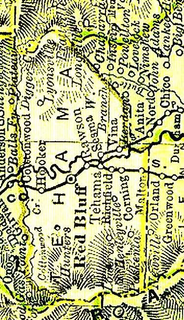
TEHAMA
   COUNTY
PLACE NAMES
               A
          Catalogue
               of
      Names and Places,
      Some Well Known,
  Others Quaint and Curious,
       Some Long Gone,
 Located within the Boundaries
               of
        Tehama County

            Compiled By

    Donald L. Hislop, M.A.
              &
   Benjamin M. Hughes, M.A.

        Red Bluff, California
               2007
2
All rights reserved.
Printed in Tehama County,
2007
No part of this work may be reproduced without permission from the authors.3
Acknowledgments
The authors take this opportunity to thank:
Opal Mendenhall
&
Gene Serr
For their invaluable editorial assistance;
The staff of the Tehama County Assessor’s Office;
The myriad of writers who have over the years contributed articles to
Tehama County Memories & Colusi County Wagon Wheels,
whose pioneering research made this modest effort possible;
and
The mostly unrecognized students from the
Red Bluff Union High School United States History classes taught by
Mr. Andrew Osborne
for their field research in local history.4
Contents
Acknowledgments . . . . . . . . . . . . . . . . . . . . . . . . . . . . . . . . . . . . . . Page 3
Contents . . . . . . . . . . . . . . . . . . . . . . . . . . . . . . . . . . . . . . . . . . . . . . Page 4
Introduction . . . . . . . . . . . . . . . . . . . . . . . . . . . . . . . . . . . . . . . . . . . Page 5
Gibbes, New Map of California, 1852 . . . . . . . . . . . . . . . . . . . . . . Page 8
Eddy, Official Map of the State of California, 1854 . . . . . . . . . . . Page 12
Mexican Land Grants in Tehama County . . . . . . . . . . . . . . . . . . . Page 15
Colton, Northern Sacramento Valley, 1854 . . . . . . . . . . . . . . . . . . Page 18
Hutchinson, Sierra Flume & Lumber Company . . . . . . . . . . . . . . Page 21
National Archives, Tehama County, 1879 . . . . . . . . . . . . . . . . . . . Page 24
Postal Route Map, 1884: North . . . . . . . . . . . . . . . . . . . . . . . . . . . . Page 26
Rand McNally, New Atlas of the World, 1895 . . . . . . . . . . . . . . . . Page 31
Barrs Historical Map of the State of California: Northern, 1896 Page 35
Aubrey, Map of California Mineral Deposits, 1910 . . . . . . . . . . . Page 37
Cram’s Unrivaled Atlas of the World, 1911 . . . . . . . . . . . . . . . . . Page 41
Judge, Wagon Road Map of California, 1914 . . . . . . . . . . . . . . . . Page 44
Bradley, California Mining Bureau, 1916 . . . . . . . . . . . . . . . . . . . Page 48
Jennings, Creeks and Rivers of Tehama County . . . . . . . . . . . . . Page 51
Lists . . . . . . . . . . . . . . . . . . . . . . . . . . . . . . . . . . . . . . . . . . . . . . . . . . Page 59
Notes . . . . . . . . . . . . . . . . . . . . . . . . . . . . . . . . . . . . . . . . . . . . . . . . . Page 61
References Consulted: WORKS . . . . . . . . . . . . . . . . . . . . . . . . . . . Page 63
References Consulted: MAPS and ATLASES . . . . . . . . . . . . . . . . Page 695
Introduction
In conducting research into the history of Tehama County, it became obvious
to the authors that no place name directory existed for the county. This project
therefore began as a compilation of names for personal use; however, as research
continued, conversations with various individuals suggested a need for the
information to be available to the general public and thus led to the creation of this
work.
To develop a comprehensive place name directory listing all cultural as well
as all physical geographic features seemed too extensive a task for the initial
publication. Consequently, the authors decided to limit themselves to areas of
human habitation or economic or cultural activity with a few prominent physical
and geographic features included. In examining place names some interesting facts
came to the authors’ attention.
One of these facts is that in looking at old, (and sometimes current), maps,
one can often find locations that appear to be towns. Examples might include
Hunters, Ensign, and Tyler. Research indicates that many of these may have never
been actual communities.
Among such locations the reader will find sites listed as “railroad siding or
switch station.” In the days of steam locomotion these might have included a water
tower. In most cases there was no habitation at the site other than possibly a
switchman’s shanty. The railroads generally designated these areas by the last
name of a nearby landowner or rancher, such as Blunt or Finnell.
In other instances, locations like Belmont, (a Sierra Flume and Lumber
Company mill located in southeastern Tehama County in the 1880s), would have
had a small community of loggers and mill workers and their families associated
with the mill.
When California was still part of Mexico, several early settlers in the
Tehama County area were recipients of Mexican land grants. When California
became part of the United States in 1848, the grant holders needed to establish title
to their land and are referred to as “claimants.” In some cases these claims were
upheld by the courts and in other cases denied. If the claim was upheld, it was
referred to as being “patented.” Claim data is included in several of the
descriptions included herein. These lands became the foundation of a great many
ranches in the region which had significant impact on the county.
Ranches often became a center point for surrounding activity and many
times one finds a post office location at a ranch headquarters, such as Blossom.
These rural “post offices” were quite different from what one encounters today.
According to the late Anne Willard McNabb, these post offices might be no more
than a cupboard in the home or store of whoever was designated the postmaster.
The mail was dropped off once or twice a week and the post mark was usually a
mark across the stamp with a handwritten date.
As well as being post offices, ranches often became school locations.
Accepted practice in the 19th and early 20th centuries was to establish schools
approximately five miles apart, probably based on what might be a reasonable
walking or riding distance for students. In many cases schools were located on6
ranches and served students from the surrounding area. Often the school was
named after the ranch or land owner.
* * * * *
Places listed in this index are shown by their location according to Township
and Range. Thus, Dale’s Station is indicated at Section 3, Township 28 North, and
Range 2 West. Many maps (Metsker’s, Forest Service, USGS Quadrangles) show
township and range markings. In some cases the township and range location is not
known or is in a land grant area that was not included in grid system. In the former
case the site is listed as PLNK (Precise Location Not Known) and in the latter case is
listed as N/A. A further explanation is included in the Notes.
Included in the work are portions of a number of maps, arranged in
chronological order, to illustrate the development of Tehama County and to provide
the reader with graphic evidence of many of the places listed in this “catalog.” A
number of maps are referred to in the entries (e.g. the various Luning and
Shackleford “Official” maps of Tehama County.), which, due to their size, have not
been included – most are mounted on walls of various public buildings. If the
reader will refer to the Maps & Atlases section of the bibliography, information is
provided as to locations where these maps may be examined.
The authors utilized a plethora of sources in attempting to accurately
describe the places that are included. In some cases there is little or no doubt about
the accuracy of the information presented. In other cases, sources disagree and in
those instances the authors have attempted to weigh the data and present what they
believe to be the most accurate. In some cases this data disagrees with local lore; in
others it supports it. Unfortunately, when one is dealing with local history often the
definitive data was never recorded or was lost because it was never considered
important.
It is the hope of the authors that this publication will prove useful to those
interested in the variety of names in the county and their etymology. Although an
attempt has been made to present some historical information about various sites,
there is often a great deal more to be said. The reader is referred to the Tehama
County Historical and Genealogical Society’s 150th Anniversary history of the
county for more in depth data. In addition, the Tehama County Library has
extensive resources dealing with local history.
Finally, the authors make no claim to total accuracy of their work and
cheerfully solicit additional data that readers may wish to share. Additional
information will be included in any further editions.7
Tehama County Place Names
Place Name T&R Location Description
Adobe Ferry Sec. 17, T27N, R5E The Adobe Ferry, which operated from 1862-
1876, crossed the Sacramento River near what is now
William B. Ide Adobe State Historic Park in Red
Bluff. In 1862, Daniel Howard built and operated a
ferry at this location. Several other operators,
including Herbert Kraft and George and Erwin
Hammans, ran ferries from this location up through
1875-6.
Alfalfa N/A1 Alfalfa was the name of a California and Oregon
Railroad siding about 1910 or 1911. It was located
north of Gerber on what is known as the old Jackson
Place. It predated Las Flores and Gerber, when all of
the land in the area was planted in alfalfa. The siding
was constructed to serve a mill which processed the
alfalfa into meal. At its peak the mill could grind and
process 7 tons of alfalfa into meal per hour. The site
was later marked by a cattle yard. The office of
Hinkle Roofing and Construction, Inc. occupies part
of the old mill site.
Antelope Creek N/A1 This name is a translation of Arroyo de los
Berrendos from John Bidwell’s 1844 map. It was one
of several creeks and locations named by Bidwell in
March of 1843, while he was searching the north
valley for horses that had been stolen from Sutter’s
Fort. Antelope Creek flows from the highlands of the
Lyonsville logging country, southwest until it reaches
the Rio de los Berrendos grant. It then turns to the
south and flows along the floodplain of the
Sacramento River paralleling the river until it enters
the Sacramento just north of 5th Avenue at the
southwest corner of the grant.
Arbuckle Sec. 35, T29N, R9W Arbuckle [first name not known] was a miner
near Platina, and sometime after 1851 the area that he
worked became known as the Arbuckle diggings. An
1879 map of Northern California assigns the name
Arbuckle to a possible community which appears to be
approximately in the same location as Beegum. There
is neither a listing in A Century of California Post
Offices5 for a post office nor is there any indication of
a school under the name of Arbuckle. The Postal Route
Map: 1884: North [See Preston] identifies neither
Arbuckle nor Beegum.
A 1910 map identifies a peak just north of the
Tehama/Shasta County boundary as Arbuckle
Mountain, but identifies the community as Beegum.
There are a number of features with the name
Arbuckle in southwestern Shasta County.8
Arcade Sec. 24, T26N, R3E The Official Map of the County of Tehama for 1878
shows Arcade as a point along the flume from the
southern Tehama County logging areas of the Sierra
Flume and Lumber Company to Chico. Barrs
Historical Map for 1897 identifies this as a small
community. According to the Rules and Regulations of
the Sierra Flume and Lumber Company for 1876,
Arcade was the most recently added sawmill in the
Chico Division. (See: maps, pp. 21 and 35)
Colusi County, 1852
From: Gibbes, New Map of California9
Basler Mining Co. Sec. 4/8, T25N, R 7W The Basler Mining and Development Company
had 11 chrome mining claims in the two sections listed.
These were located about a mile north of the Grau
(Grey) Mine and straddle Colyear Springs Road.
They are simply identified as “Mine” on the
Mendocino National Forest Map in Sec. 8. This mining
district also produced copper ore.
Battle Creek Sec. 11, T29N, R3W Battle Creek is the northern border of Tehama
County east of the Sacramento River to Manton. This
may be the creek designated as Arroyo de la Campana
on a map of Rancho Breisgau, an 1844 grant in what is
now Shasta County. On an 1848 map, made by John
C. Fremont, it was called Noza Creek; however, it
became known as Battle Creek after a bloody
engagement was fought there between trappers and
Indians in 1849. That name appeared on the 1854
map drawn by Beckwith and has been used ever since.
Battle Creek originates in the volcanic highlands east
and north of Mineral and flows northeast across
Tehama County to join the Sacramento River at
Bloody Island.
Beegum Sec. 35, T29N, R9W Located in extreme northwestern Tehama
County, this hamlet was named after Beegum Creek
and Beegum Peak, so named because the peak
resembled a dome shaped beehive commonly used in
the South. The limestone peak is honeycombed with
caves, some of which actually have bee colonies. A
post office was established in Beegum, Shasta County,
on Dec. 6, 1895. By January 1900, the Beegum post
office was moved ¼ of a mile into Tehama County and
the post office was redesignated. The post office was
moved to Knob, Shasta County, in December of 1917.
The precise location of Beegum depends upon the
map being viewed. Neither Barrs Historical Map of
Northern California nor Luning’s 1903 map show
Beegum. However, Luning’s 1926 map places Beegum
approximately 1 mile south of the Shasta-Tehama
boundary, which in this area is Beegum Creek. The
1930 Metsker’s map and the Harry Freese maps both
place Beegum just north of Beegum Creek in Shasta
County, and an American Automobile Association
map, circa 1972, places Beegum in Shasta County.
The Soil Survey Map of Tehama County places Beegum
just inside the Tehama County line. Durham’s places
Beegum in Shasta County.
Belle Mill [site] Sec. 4, T28N, R2E This was the site of the first of the major sawmills
to be built in the Lyman Springs area of Tehama
County. It was located in the Antelope Creek
watershed near the present location of Lyman Springs.
The original Belle Mill was built by Kellum Powell,
William Need and "Captain" Sam Crossan about
April, 1869. It was apparently named “Belle” mill
after Mrs. Belle Eskridge who was the first woman to
live at the mill. The lumbermen were so taken by10
having a woman in the camp that they named the mill
after her. This mill was acquired by C.F. Ellsworth
and was later (1872 ) to become the beginning point of
the Empire Lumber Company Flume to the
Sacramento River at Sesma. The mill was destroyed
by fire in 1878 and was not rebuilt. In the 1874 edition
of the Business Directory: State of California, “Belle
Mills” is listed as a “principal town” along with
Tehama and Vina.
Belmont Sec. 24, T26N, R3E The “Official Map of the County of Tehama” for
1878 shows Belmont as point along the flume from the
southern Tehama County logging areas of the Sierra
Flume and Lumber Company to Chico. Barrs
Historical Map for 1897 identifies this as a small
community. According to the “Rules and Regulations
of the Sierra Flume and Lumber Company” for 1876,
Belmont sawmill was one of the mills in the Chico
Division of the SF&LCo. (See: maps, pp. 21 and 35)
Bend Sec. 28, T28N, R3W The Bend District, located 8 miles north of Red
Bluff, was named after the “bend” in the Sacramento
River. In early days it was called Horsethief Bend
because horse and cattle rustlers could easily hide in
the brush that covered the area. The area was known
as Sanders Bend prior to the arrival of Nathaniel
Hazelton, in 1859. Hazelton used a rowboat to ferry
settlers across the river. In 1892, Herbert Kraft had a
ferry built and paid Jack Davis to operate it. The
ferry was in service until the Bend Bridge was built in
1932. The Bend post office was maintained from
January of 1897, until May of 1935 when it was moved
to Red Bluff
Bend Ferry See: Bend, above.
Benton City N/A1 Benton City, named after U.S. Senator Thomas
Hart Benton (also known as Lassen’s Landing) was a
planned community laid out by Peter Lassen in 1847.
It was located at the western end of the Lassen Trail at
the mouth of Deer Creek. For a short time it boasted
a sawmill, a grist mill, a hotel and blacksmith shop. A
granite monument near the north bank of Deer Creek
on Highway 99E marks the site.
Bingen Sec. 34, T29N, R5W Bingen was located 9 miles southwest of
Cottonwood, between the Bowman district and
Rosewood. Measuring that distance along the
Cottonwood-Rosewood line on Metsker’s Map of
Tehama County places this location approximately at
the junction of Bowman and Farquhar Roads.
According to some sources, the Bingen post office was
located on the same site as the later Farquhar post
office. Other than the known facts that it had a post
office from March, 1886 until it was moved to
Cottonwood in April of 1887 and that Henry Heckert11
was the postmaster, little is known about this place.
Like a number of the post offices identified by both
Frickstad and Salley, Bingen does not show up on any
map examined by the authors; however, the name H.
Heckert does appear on the 1903 Luning map of
Tehama County in Section 34, Township 29 North,
Range 5 West, which is the same location for the
junction of Bowman and Farquhar roads.
Bloody Island T29N, R3W Bloody “island” is located in the Sacramento
River at the mouth of Battle Creek. Due to a change in
the channel of the river, it is no longer truly an island.
The Indians in the area apparently called the island
Arrowhead, but it was named in 1844 by Samuel J.
Hensley from Sutter’s Fort after his party was
attacked by Indians at this location. Another possible
derivation of the name is attributed to a bloody battle
between Indian raiders from the Hat Creek region and
local Indians. After this battle the Sacramento was
said to have “run red with blood.” John C. Fremont’s
men staged a bloody massacre on the island in 1846,
and Dr. John Stockton made the suggestion that the
island be named Fremont Island, but the idea never
took hold.
Blossom Sec. 21/22, T27N, R5W The community of Blossom never included more
than the buildings that made up the headquarters of
the Robert Hurd Blossom ranch. When founded in
1882 the ranch included 10,240 acres and had
expanded to 26,000 acres at the time of Blossom’s
death in 1903. The Blossom post office was located on
the north fork of Reeds Creek (also known as Liza
Creek) about 12 miles west of Red Bluff and 6 miles
south of Manzanita. This post office was established in
February, 1896 and was maintained there until it was
moved to Red Bluff in August, 1907. This location was
at one time part of the Owens Estate and is now the
headquarters of the Atwood Ranch. Blossom School
was located on the Blossom Ranch but was located at
the junction of Cannon Road and Highway 36W, not
at the headquarters. (See: Manzanita. See: map p. 44)
Blue Tent Creek Sec. 9, T27N, R3W This creek has its origin in the foothills northwest
of Blunt and enters the Sacramento River
approximately one mile northeast of Ide Adobe State
Historic Park. One legend concerning the origin of the
name of this creek is that a miner pitched a blue
canvas tent on its bank while searching for gold in the
area. (Alas, there is no gold in this portion of the
Sacramento Valley!). Another version suggests that
the name comes from a large blue tent that served as a
stage station on the old California-Oregon stage road.
Blunt Sec. 36, T28N, R4W Blunt appears on several maps (e.g. the Harry
Freese Map of Tehama County); however, it appears to
be nothing more than a siding and a switch station on
the Southern Pacific Railroad6.12
Bohemia N/A1 Bohemia was the name given to a hop ranch
located 2 miles south of Los Molinos because of the
bands of Gypsies who gathered the crop each year. It
was a busy place when hops were a promising industry
in the area.
Bosquejo Rancho N/A1 Generally taken to mean “The Wooded Ranch,”
Bosquejo Rancho was named for the riparian forests
that lined the river. In 1844, five leagues of land were
granted to Peter Lassen east of the Sacramento River
and south of Deer Creek. This grant overlapped what
is today both Tehama and Butte Counties. (See: Map
of Land Grants, page 15.)
Brewery Creek Sec. 20, T27N, R 3W Brewery Creek flows through then north central
portion of Red Bluff into the Sacramento River at the
north end of the bend in the river. As its name
implies, it was the site of several breweries in the early
days of Red Bluff.
Tehama County, 1854
From: Eddy, Official Map of the State of California13
Brickyard Creek Sec. 29, T27N, R3W Brickyard Creek, named for a brick works that
was located along it in the early days of Red Bluff,
flows 9 miles into Reeds Creek near the center of Red
Bluff.
Buckeye Sec. 15, T29N, R4W Buckeye was a railroad switch and siding that was
established in the 1870s, shortly after the railroad was
built into Cottonwood. In 1880, a section house was
built on the site. In the early years of its existence, the
Buckeye switch was important to the railroad
company and they made a concerted effort to promote
its development and to develop a station there.
Unfortunately the effort came to naught. It was
located 2 miles southwest of Cottonwood where
Bowman Road crosses the Union Pacific6 (formerly
Southern Pacific) railroad tracks. As business
diminished over the years the switch and siding were
discontinued. (See: Cram’s, p. 41)
Bulltown Sec. 20, T27N, R3W One of the small communities located in the area
that eventually became the town of Red Bluff,
Bulltown was named for Alpheus Bull, one of the
area’s earliest merchants.
Campbellville Sec. 13/14, T25N, R2E Campbellville is shown on the 1929 Lassen
National Forest map as a small community. It is also a
road, a peak (Campbellville Mound; Sec. 36, T25 N,
R1E), a fire lookout, and a spring, all located in
southeastern Tehama County. Maps also list
Campbell Ridge and Campbell Creek. [Metsker’s]
Capay Rancho N/A1 The origin of the name is found in the southern
Wintu word for “stream.” In 1844, 10 leagues were
granted to Josefa Soto, who later was claimant to
44,388 acres, which was patented in 1859. Pierson B.
Reading claimed 5 leagues of this grant, but his claim
was rejected by the claims court. The Capay grant
spanned from Kirkwood in Tehama County to
Hamilton City in Glenn County. (See: Map of Land
Grants, page 15.)
Cascade Sec. 18, T26N, R4E The “Official Map of the County of Tehama” for
1878 shows Cascade as point along the flume from the
southern Tehama County logging areas of the Sierra
Flume and Lumber Company to Chico. Barrs
Historical Map for 1896 identifies this as a small
community which was some four miles southwest of
Lyonsville. According to the “Rules and Regulations
of the Sierra Flume and Lumber Company” dated
1876, Cascade was a sawmill in the Chico Division.
(See: Maps, pp. 21 and 35).
Cavortsburg Sec. 20, T27N, R3W Also listed as Cavertsburg and Covertsburg, this
was one of the small communities located in the area14
that eventually became the town of Red Bluff. It was
named after M.C. Cavort who homesteaded along the
river south of Reed’s Creek.
Champion Mill [site] Sec. 11, T28N, R2E There were two Champion Mills. The “Old”
Champion Mill was an early sawmill built by Herbert
Kraft. In 1870 this mill became part of the C.F.
Ellsworth complex of mills in the Antelope Creek
drainage. The second Champion Mill, at what is now
called "Old Lyonsville,” was built by Sierra Flume
and Lumber Co. and was designated "Champion #2"
to distinguish it from the original Champion Mill
south of Howard Meadows. When first built in
1876/77, this mill was a steam mill with 2 circular
saws rated at 30 thousand board feet per ten hour day.
This mill operated for 15 years before it burned in
1891. It was rebuilt and operated for another 16 years
before it burned again in 1907. Diamond Match
acquired the Sierra Lumber Company in 1907 and
rebuilt the mill in 1908, only to dismantle it and move
the equipment to Sterling City in 1913.
Childs Meadows Sec. 24, T29N, R4E Located approximately 45 miles east of Red Bluff
on the old Red Bluff -Susanville-Humboldt Toll Road,
(now Highway 36E), the property was originally
owned by J.C. Tyler who used it for summer grazing
land. He established a resort about 1864 and a stage
stop had been established by 1896. He later sold the
land to Abner Nanney in 1900, who then sold to Frank
Childs who used it for summer grazing in 1909. In the
late 1930s a service station and café were established
at Childs Meadows followed by hunters’ cabins. It
was later developed into a resort which still exists.
Cold Fork Sec. 20/30, T27N, R7W Cold Fork, according to the 1915 Postal Route
Map (p. 26), was located 15 miles southwest of
Hunters. In January of 1915, a post office was
established on the Cold Fork of Cottonwood Creek
and maintained until July, 1920, when it was moved to
Hunters. Cold Fork is indicated on the Metsker’s Map
as being a “district” rather than a community. There
is some indication that there may have been a Civilian
Conservation Corps (CCC) camp at Pettyjohn Place
near Cold Fork. (See: Note 7.)
Colusi, Colusa County Prior to 1856, the portion of present day Tehama
County south of Red Bank Creek was part of Colusi
County. Many of the early places in southern Tehama
County may be found in sources dealing with Colusi
County which was named after two Mexican land
grants: Coluses (1844) and Colus (1845). The name of
the county in the original state legislative act was
spelled Colusi, and in newspapers was often spelled
Coluse. The word is derived from the name of an
Indian tribe living on the west side of the Sacramento
River. Colusi became Colusa on legal documents in15
Mexican Land Grants in Tehama County
Antelope Creek
Reeds Creek
El Primer Can on
or
Rio de Los
Red Bank Creek Berrendos
La Barranca Colorado
Oat Creek
De Las Flores Rancho
Rio Mill Creek
Elder Creek
Saucos de Los
Rancho
S Molinos
Thomes Creek A
C Deer
R Creek
A
M
E
N Bosquejo
T
O Rancho
N I
R
Capay Butte
Rancho V
County
E
R
Tehama County
Glenn County
Map by B. Hughes, 200716
1854 when the county seat moved from Monroeville to
Colusa.
Colyear, Colyer Sec. 13/24, T26N, R5W Named in honor of John G. Colyear who settled
and homesteaded in the area in 1862, Colyear was
located approximately 10 miles southwest of Red
Bluff. In 1882-3 a school was established on the
property. The school served students until it closed in
1914, but the building served as a community center
for many years after. According to A Century of
California PostOffices5, a post office was established at
Colyear in July, 1889 and maintained until April, 1894
when it was moved 5 miles west to Eby. (See Eby &
Red Bank)
Colyear Springs Sec. 30, T26N, R7E Located approximately 35 miles west of Red Bluff,
Colyear Springs was named for John G. Colyear who
purchased the springs from George Puls. By 1904
several cabins were established in the area as retreats
from the summer heat of the valley. A post office was
established in October, 1905, but it was moved to
Lowery in August, 1910. In 1919 Dr. J.A. Owen, Sr.
purchased Colyear Springs and established a short-
lived health camp for children. The area was used for
some years as a mountain resort. A lumber mill was
located at Colyear Springs Mill, which was operated
by various individuals until it burned in 1948; Frank
Watson built and operated a mill for a time in the
1950’s. Currently there is a 2-story home near the
springs that is used by the Anchordoguy family as a
summer retreat.
Comosa T25N, R3W [PLNK2] Comosa is a little known community. It is
identified on the 1884 Postal Route Map: North (p. 26),
as being 6 miles southwest of Tehama on the Tehama-
Paskenta Road just north of Thomes Creek. A post
office was established at Comosa in August, 1880, and
was discontinued in September, 1882. It was
reestablished in May, 1884 and moved to Tehama in
October, 1885. While Comosa is shown on this map,
there is no Township and Range grid on the map.
(Preston)
Cone, Cone Colony N/A1 The Cone Colony was inspired by and named for
Joe Spencer Cone, a wealthy cattleman and wheat
grower in the 1850s. The Colony was located within
the Cone ranch property, which was part of the
Rancho de los Berrendos grant. Cone was a partner
of Major Gorham Gates Kimball and together they
built the landmark Cone and Kimball building which
served for many years as a symbol of the city of Red
Bluff. Today the name is carried on by Cone Grove
Park, a popular picnic and gathering place
approximately 5 miles south of Red Bluff and east of
Highway 99E, and the Cone Community United
Methodist Church located in Dairyville.17
Copeland N/A1 Copeland was a railroad siding or switch station.
Copeland was located approximately 1.5 miles north
northwest of Vina near the Vogalsang Ranch. (See:
Cram’s, p. 41]
Corning Sec. 22/23, T24N, R3W In 1882 the Pacific Improvement Company, a
subsidiary of the Central Pacific Railroad,6 laid out a
town named in honor of John Corning, the general
manager of the railroad. The route of the railroad
bypassed Riceville, an earlier community
approximately 1 mile west of present day Corning.
When Corning was founded, the Riceville post office
was relocated to Corning. Today, Corning is the
second largest community in Tehama County. It was
home to the Lindsay Olive Company and now Bell
Carter Olive Packing and is known as the “Olive
Capitol” of California. (See: Maywood Colony &
Riceville.)
Cottonwood (community) Sec. 11, T29N, R4W Cottonwood is one of the oldest farming
communities in Shasta county, but it was for a time
considered to be in Tehama County. The first post
office was established in the community in February of
1852; however, after the creation of Tehama County
and the designation of Cottonwood Creek as the
Shasta-Tehama County boundary in 1856,
Cottonwood was effectively a two county town. In
March, 1860, the post office was moved to Tehama
County. This move apparently led the map makers to
exclude Cottonwood from the 1862 map of Shasta
County. The Cottonwood post office was maintained
in Tehama County until September, 1872, when it was
moved back across Cottonwood Creek into Shasta
County. In 1857, John Barry purchased most of the
south side of the community. Cottonwood School
(Barry School) was established in 1860 and in 1953
combined with Farquhar School to become Evergreen
Union School District.
Cottonwood Creek Sec. 10, T29N, R3W On an early map, John Bidwell named this creek
for the cottonwood trees that grew in abundance along
its banks. The course of this creek is the boundary
between Tehama County and Shasta County west of
the Sacramento River.
Coyote Creek N/A1 This creek flows 18 miles through the La
Barranca Colorado land grant into Oat Creek
approximately 1.5 miles north northeast of Gerber. It
is thought to have been named for a coyote that
plagued early settlers. Sheep herders reported that
“Old Two Toes” could not be shot. Much to the joy of
the settlers, the offending coyote was finally tracked
down and killed.
Dairyville N/A1 Dairyville was a planned village located 7 miles
east -southeast of Red Bluff. It was laid out and18
surveyed for the Los Molinos Land Company to be a
trading center mid way between Los Molinos and Red
Bluff. Originally called Dairy because of the many
dairies in the area, Dairyville once boasted two general
stores, a theater, blacksmith shop, cheese factory,
alfalfa mill and school. The Cone Community United
Methodist Church, a local landmark, was built about
1918.
Dale’s Station, Dales Sec. 3, T28N, R2W Located 14 miles northeast of Red Bluff on the
Red Bluff – Susanville – Humboldt Toll Road (now
Highway 36E), it was originally known as DeHavens
stage stop then as the Ross Gates stage stop. A two-
story hotel and stables, built on the south side of
Paynes Creek, were purchased about 1908 by the Dale
family. For many years a restaurant and gas station
were located here. Current maps have dropped the
apostrophe and designate the location simply as
“Dales.”
Colton, Northern Sacramento Valley, 1854
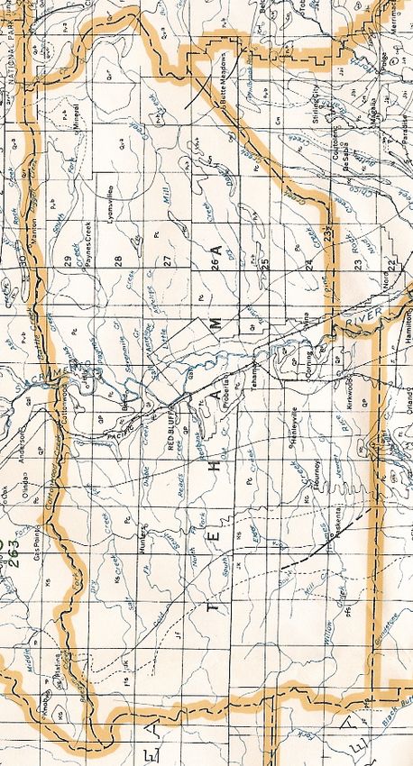
From: Capron, E.S., History of California, 1854.19
De Las Flores Rancho N/A1 The Ranch of the Flowers. Three leagues between
Tehama and the Red Bluffs were granted to
WilliamChard in 1846. He later became claimant to
13,316 acres which were confirmed and patented in
September, 1859. This grant lies west of the
Sacramento River between Josiah Belden’s (later
William B. Ide) La Barranca Colorado grant and
Robert Hasty Thomes’ Rancho de las Saucos grant.
(See: Map of Land Grants, p. 15.)
Deer Creek N/A1 Named by John Bidwell, this creek was originally
designated on maps as “Arroyo de los Venados” and
“Rio de los Venados.” This creek marked the
northern boundary of Peter Lassen’s Bosquejo
Rancho. The south side of the juncture of the creek
with the Sacramento River was the site of Lassen’s
1844 adobe home, which was the first non-Indian
habitation north of Marysville. Deer Creek originates
in the Cascade Mountains of Eastern California and
flows south and west across eastern Tehama County to
empty into the Sacramento River 1.5 miles west
southwest of Vina.
Diamond Range See: Riley.
Dibble Creek Sec. 19, T27N, R3W Dibble Creek was named for Abraham Dibble,
who, in 1852, owned the property and probably built
the adobe structure that is currently the centerpiece of
William B. Ide Adobe State Historic Park in the
northern portion of Red Bluff. Dibble Creek flows for
15 miles east from the rising highlands of the Coast
Ranges to enter the Sacramento River just west of the
location of the State Historic Park.
Digger Creek T30N, R1-4E Digger Creek originates in Lassen Volcanic
National Park near Brokeoff Mountain. The person
or persons who named this creek used a derogatory
term to refer to the Native Americans of the Nevada
Desert and California who routinely dug for roots to
supplement their diet. Digger Creek flows for 19
miles westward to join Battle Creek approximately 2
miles west of the mountain community of Manton.
The course of Digger Creek is the northeastern
boundary between Tehama and Shasta Counties in the
Manton area.
Dobson PLNK2 Dobson was named after Malinda Dobson, the
first postmistress. According to A Century of
California Post Offices5 a post office was established
6.5 miles southwest of the Hunters post office in
February, 1896, but a short 15 months later, in May,
1897 it was moved to Blossom. Like a number of the
post offices identified by both Frickstad and Salley,
Dobson does not appear on any map examined by the
authors.20
Draper Sec. 15, T29N, R4W Draper was a railroad switch station and siding
located approximately 2 miles south of the town of
Cottonwood and 4 miles north of Hooker where
Draper Road crosses the railroad tracks. [CPRR6
Map]
Dye Creek T26N, R2W Dye Creek was named for Job Dye, the owner of
the Primer Canyon or Berrendos Grant. Dye Creek
begins in the Ishi uplands of eastern Tehama County
and flows for 15 miles westward through the southern
corner of the Rio de los Berrendos grant to flow into
the Sacramento River between 5th and 6th Avenues on
Highway 99E south of Dairyville.
Eby Sec. 17, T26N, R5W Named for landowner Jackson Eby, the location
of and data regarding Eby is elusive. Shackelford’s
1887 Official Map of Tehama County identifies Eby at
the location given, just south and west of the Ridge
Road/Red Bank Road junction; however, it is not clear
if this is anything more than simply a ranch. The 1914
Wagon Road Map of Northern California (p. 44) and
the Barrs Historical Map for 1896 (p. 35), both indicate
a town at the junction of two roads approximately 14
miles southwest of Red Bluff on Red Bank Creek on
the way to Lowrey; however, neither of these maps
have accurate Township & Range grids. The location
of Jackson Eby’s home is currently the site of the
Murchison Ranch and home. The Eby post office was
established in April, 1894, and maintained until it was
renamed Red Bank in June of 1904. It was
discontinued in 1918. According to articles in the Red
Bluff Daily News in 1901/2, the Eby Post Office was
near the Red Bank Presbyterian Church, which was
15 ½ miles west of Red Bluff. This would place Eby in
the hub of what is today known as the Red Bank
district. (See: Red Bank)
El Camino N/A1 El Camino is a rural community and irrigation
district which is located a few miles north of Richfield
on Highway 99W. It is on the property of the old
Finnell Ranch, which later became the El Camino
Colony. Today El Camino has a grange hall, fire
station and the El Camino United Methodist Church.
Elder Creek Sec. 4, T25N, R3W Elder Creek flows through part of the Rancho de
las Saucos Mexican land grant of Robert H. Thomes.
The name is derived from the elder trees that grow
along the creek banks and appears on Bidwell’s 1844
map as “Arroyo de los Saucos,” arroyo of the elders. It
flows eastward from the Coastal Range foothills,
crosses under Interstate-5 at the location given and
into the Sacramento River just north of Tehama.
Ensign N/A1 Ensign was a railroad switch station and siding
located south of Red Bluff mid way between Bohemia21
Sierra Flume & Lumber Company
From: Hutchinson, California Heritage: A History of Northern California Lumbering
and Copeland approximately 4 miles north northwest
of Vina. (See: Cram’s, p. 41.)
Farmington N/A1 Originally known as Scatterville, the community
was renamed Farmington in 1872 when Charles
Philander Rice settled 160 acres and built a store at
the junction of what is now Highway 99W and Solano
Street on the western edge if present day Corning.
Because he disliked “Scatterville” he named the store
“Farmington.” By the end of 1872, the community
boasted Rice’s store and hotel, a butcher shop,
blacksmith shop, a saloon and a contractor and
carpenter’s shop. In all 14, businesses clustered
around the Farmington store. With so many people, it
seemed wise to have a school, thus, in 1872, a district
was created and the Washington School was erected at
the junction of what is now Corning and Rawson22
Roads. A post office was established in Farmington,
about 1875, but was discontinued. (See: Scatterville,
Riceville & Corning.)
Farquhar Sec. 6, T28N, R5W Farquhar was named in honor of Col. George C.
Farquhar, a Tennessee native who settled the area in
the early 1850s. He was one of the first settlers in the
Cottonwood area. Farquhar is listed in A Century of
California Post Offices5 for Tehama County. A post
office was established on the site of the former Bingen
post office in August, 1891 and it was maintained there
until it was moved to Cottonwood in June of 1893. In
1875 a school was established in Farquhar and it
served students through the 1952 – 53 school year.
Finnell T25N, R3W PLNK2 Finnell was most likely a railroad siding or switch
station. Finnell was located approximately midway
between Richfield and Tehama on the Finnell Ranch.
It is identified on the Barrs Historical Map for 1896 (p.
35) and on the 1914 Wagon Road Map of California (p.
44). Later maps identify Finnell Road in this vicinity.
[See: Cram’s p. 40)
Flournoy Sec. 21, T24N, R5W Located 6 1\2 miles southwest of Henleyville and 6
1\2 miles northeast of Paskenta, the town was named
after George H. Flournoy, a Confederate veteran, who
had raised sheep and cattle in the Henleyville area
from 1870. The Flournoy post office was established
in August of 1908 in the store built earlier that year by
G.M. Snelling. The Flournoy Union School District
was formed in 1920. This school district incorporated
the older districts of Gleason, Shultz, Burton, Elkhorn,
Elmore and Headquarters, all of which had lapsed a
year or so earlier.
Forward Bros. Mill [site] Sec. 26/27, T30N, R2E The mill was built and operated by the Forward
brothers, Frank and Alfred. They established the first
water-powered mill about three miles east of Manton
in 1893. It was one of the early mills, along with
Clipper Mill (built in 1871) and Love’s Mill (1866)
that conducted logging operations in the Digger Creek
drainage east of Manton along the Shasta-Tehama
County boundary. The Manton Mill was destroyed by
fire in 1956. The Forward family operated mills
Tehama County until 1963.
Gerber N/A1 Located 11 miles south of Red Bluff, (2 1\2 miles
northwest of Tehama and 2 miles southeast of
Proberta), the present site was once known as
“Logan’s field” after an early settler by the name of
Pleasant D. Logan, who, in 1860, purchased 1000 acres
of land in the Proberta area for 20 cents an acre. At
some point the land became the property of the
Gerber family. A town site for the town of Gerber was
surveyed and laid out in 1910. W.E. Gerber, of
Sacramento, sold the land to Southern Pacific23
Railroad6 in 1916. S.P. constructed an engine house,
an icing plant, livestock corrals and a passenger and
freight station, and named the town Gerber in his
honor. Gerber was the southern end of the Southern
Pacific’s fabled South Shasta Division, which ran from
Gerber to Dunsmuir in Shasta County. A post office
was established in Gerber shortly after its founding in
August of 1916.
Gleasonville Sec. 12, T24N, R5W Gleasonville was a stage stop on the Paskenta road
approximately 13 miles northwest of Corning, or
approximately half way between Henleyville and
Flournoy, on the way to the Nome Lackee Indian
Reservation. Named after John Gleason who settled
in the area in 1855, the settlement had a large 2-story
residence built by Gleason in 1868, which was used for
overnight lodging, a tavern, blacksmith shop, livery
stable, dance hall and school (established in 1881), but
it did not have a listed post office. Gleason’s house was
used until it was torn down in 1951. The Henleyville
post office was moved there on December 5th, 1878;
however, this was short lived, as it was transferred
back to Henleyville in September of 1880. In 1919
Gleason school absorbed the Headquarters School (see
Nome Lackee Reservation). Gleason School, Shultz
School and a portion of the Lowery school district
were combined to create the Flournoy school district
in 1920-21 (see Flournoy and Lowry). A small article
on page 33 of Judge Gans’ Scrapbook notes that what
was Gleasonville was formerly located on the ranch
owned by Alfred Kuhn. While it is a poor map, the
map from the National Archives (p. 24), showing
Tehama County in 1879, shows the approximate
location of Gleasonville.
Government Flat Sec. 11, T23N, R10W This was the second stopping point (the first was
Commissary Springs) on the California Indian “Trail
of Tears” from Paskenta to the Round Valley
Reservation at Covelo. After the Indians had been
moved from the Sacramento Valley to Round Valley,
the U.S. Army established a post and stockade at
Government Flat and patrolled the summit of the
Coast Ranges to apprehend, hold and return any
Indians who were attempting to escape from Round
Valley and return to the Sacramento Valley.
Grau Mine Sec. 17, T25N, R7W The Grau Mine, also known as the McLaughlin
Applegarth Mine, was a chromite mine located along
the North Fork of Elder Creek. It is identified on
Metsker’s maps of Tehama County and the Mendocino
National Forest map that is for sale to the public at
U.S. Forest Service offices.
Grove City N/A1 At one time this was a rural hamlet located
approximately 6 miles southeast of Vina. While it had
a post office, it never had more than 50 inhabitants24
Tehama County, 1879
From: National Archives
[While not the best of maps, this does show the Round Valley Reservation, the 20
and 30 mile limits for railroad land grants and the mysterious “Arbuckle.”]25
and disappeared long ago. Some sources refer to this
the area as Little Pine Creek. The Grove City post
office was established in June of 1858 and David
Rowles was the postmaster. This office was
discontinued in August of 1864. Today Rowles Road is
located south and east of Vina.
Halfway House PLNK2 Halfway House was a stage stop and hostelry
located approximately 19 miles east of Red Bluff on
the Belle Mill Road (today known as Hogsback Road).
Named because it was halfway between Red Bluff and
Lyonsville, a settlement was at this location as early as
1874, but the stage stop called “Halfway House” was
not built until 1886. At its height, there was a hotel,
livery barn, corrals, slaughter house and a school.
When Diamond ceased operations at Lyonsville in
1912, Halfway House began to decline and today
nothing remains at the site.
Henleyville Sec. 8, T24N, R4W This community was named after William N.
Henley, who, with his brother Steven, raised stock in
the area after 1860. Henleyville was located 6.5 miles
east northeast of Flournoy on property owned by J.M.
Howell, in the southwestern portion of Tehama
County just north of the Corning-Paskenta Road. It
once boasted a Methodist church, post office
(established in May, 1873), general store, blacksmith
shop and the Howell school. Early church services
had been held in homes or the school before the
church was built in 1899. The Henleyville post
Office (see Gleasonville) was closed and moved to
Corning in November of 1936. The last service in the
church was held in January of 1943 and the school
closed in the same year. During World War II, the
school reopened for the 1945-6 school year only to
close permanently in June of 1946. An interesting side
light to the history of Henleyville is that in 1887 it
placed its name in the running for the location of the
northern branch of the state normal school. The site
that was chosen was Chico and the northern branch of
the state normal school is now California State
University, Chico.
Hooker Sec. 9, T28N, R4W Hooker was a small community in northern
Tehama County named after J.M. Hooker who settled
near the mouth of Hooker Creek in 1852. The
California and Oregon6 Railroad Company
constructed a siding and depot at Hooker and freight
trains stopped daily for mail and freight. Several
prosperous farmers, ranchers and orchardists settled
in the area and they provided revenue for the railroad.
Between 1875 and 1905 the railroad stationed a section
crew at Hooker to maintain the track from Blue Tent
Creek to Anderson. The Hooker post office was
maintained from November of 1885 until it was moved
to Red Bluff in October of 1928. Prairie School26 Tehama County, 1884 From: Postal Route Map, 1884: North
27

                                               District was established in the area in 1880. The
                                               school house was located 1 ½ miles from Highway 99
                                               (today’s I-5) on Hooker road. Prairie School was
                                               closed in 1888, and that year a school was built near
                                               Hooker Station. Hooker School served students until
                                               it was closed in the fall of 1946, according to the
                                               Tehama County Schools Directory,

Hooker Creek           Sec. 9, T28N, R4W           Hooker Creek was named for J.M. Hooker. It
                                               flows east then north to join Cottonwood Creek
                                               approximately one mile west of where Interstate 5
                                               crosses Cottonwood Creek.

Hunters, Hunter P.O.   Sec. 9, T27N, R6W           Named for a man who settled on the South Fork
                                               of Cottonwood Creek, Hunters was a stopping point
                                               approximately 17 miles west of Red Bluff on Vestal
                                               Road. There are early references that name the road
                                               Hunter Road; however, this name does not show up on
                                               any of the maps examined. According to Metsker’s
                                               maps, Hunters was located approximately 4 ½ miles
                                               south of Rosewood. A Century of California Post
                                               Office, 5 notes that a post office was established in this
                                               location in October, 1888. Over the years, Hunters
                                               absorbed other post offices (see Cold Fork, Riley and
                                               Rosewood) until it was closed and moved to Red Bluff
                                               in October, 1930. According to some older sources,
                                               Hunters is often referred to as a District. This could
                                               mean a smallish community or it could refer to the
                                               Hunters School District. A school district was
                                               established at Hunter in 1871 and it served students
                                               until it was closed and the area became part of the
                                               Farquhar District in the fall of 1948.

Ivrea                  Sec. 9/10, T28N, R4W        Ivrea was a railroad switch and siding located 2.5
                                               miles south southeast of Hooker and north of Blunt on
                                               the Central Pacific6 railroad north of Red Bluff.
                                               (CPRR Map) (See: maps, pp. 44 and 48.)

Jelly                  Sec. 27/34, T29N, R3W        Jelly was a small community that served the
                                               Saron Fruit Colony. Located approximately 1mile
                                               north of the ferry, Jelly’s Ferry Store and Jelly School
                                               (built in 1896), were located here. The school served
                                               students until 1944. A post office was maintained in
                                               the store from April of 1901, until it was moved to Red
                                               Bluff in February of 1934. According to the Postal
                                               Route Map of 1884, the Jelly P.O. was located 18 miles
                                               north of Red Bluff.

Jelly’s Ferry          Sec. 3, T28N, R3W            Jelly’s Ferry was located 10 miles north of Red
                                               Bluff on the old California Stage Company route that
                                               went from Red Bluff to Shasta. The ferry and two-
                                               story house that served as a way station, hotel and
                                               ranch headquarters was built by Andrew Jelly in the
                                               1850s. He began ferry service in 1857 and operated it
                                               until 1890 when Tehama County took over and ran
                                               the ferry until a steel bridge was built in 1950. The
28
ferry was then floated down to Red Bluff and became
the Red Bluff Marina. The Marina lasted until about
1960.
Kanlos PLNK2 Kanlos was a town site laid out between Cooper’s
(Reeds) Creek and Red Bank approximately one mile
west of the Sacramento River. The land for the town
was deeded by Messrs Cooper and James Ide to
Edward Mirville. The town, to have been on the old
border of Colusi and Shasta Counties, never
materialized and today is a nearly forgotten name.
Keefer’s Sawmill Sec. 26, T25N, R2E The Official Map of the County of Tehama for 1878
identifies Keefer as sawmill site in the southern
Tehama County logging area of the Sierra Flume and
Lumber Company. Barrs Historical Map of the State
of California, Northern Half Edition; 1896, is the only
map that identifies this location as a community, but
misidentifies the site as “Keeler”. The 1929 Lassen
National Forest map clearly identifies Keefer’s Mill in
the location given, but indicates that the Butte-
Tehama County line is approximately 1 mile to the
west, placing the mill in Butte County.
Kirkwood Sec. 11, T23N, R3W To all intents and purposes, this can be put in the
“vanished town” classification. Montgomery School
was constructed in the area in 1871 on property owned
by William Watkins. In 1878 the school was moved to
property owned by a Mr. Montgomery and was
known for a time as Montgomery school. The school
was later moved to a site on Kirkwood Road and
renamed the Kirkwood School. It survives to this day
as the Kirkwood Elementary School/District. In 2004-
5 the enrollment was 29. When the railroad built a
depot near the DePue warehouse and scale, it became
imperative that the community have a name. The
name “Kirkwood” was suggested for Samuel J.
Kirkwood, Secretary of the Interior at the time. The
town of Kirkwood, located 6 miles south of Corning,
grew up around the railroad station (which was torn
down in the 1950s). A post office was established in
January of 1886 and maintained until it was moved to
Corning in August of 1953. At one time the ownership
of the Methodist Church property in Kirkwood was
open to dispute. They were informed that the property
had a mortgage that they would have to pay off. To
solve the problem, some members of the community
put logs under the church and rolled it to a nearby lot.
Church attendance was reported to have dropped by
one. In 1891 a Presbyterian Church was built in
Kirkwood, but it was moved to Corning. When the
hotel was torn down in the mid 1950s very little was
left of this community. Other than a number of homes
in the area, the Kirkwood school and the Kirkwood
Cemetery are the only reminders of this community.29
Kiska N/A1 Kiska was a switch station located at the north
end of the Gerber yards less than ½ mile south of Las
Flores. It is worthy of note that Kiska was named
during World War II, sometime after mid-1942 when
the Japanese took the Aleutian island of Kiska at the
same time they attempted to take Midway Island.
Kiska later became the site of a protracted siege to
wrest it from the Japanese.
Kleinsorge Mine Sec. 27, T25N, R7W The Kleinsorge mine was a chrome mine that was
located on the Middle Fork of Elder Creek. The mine
opened in 1916, began production in 1917 and
produced ore off and on until 1958. The site contained
mine buildings, an aerial tram and processing mills.
This mine was one of the richest chrome ore producers
in the United States. The site is identified on Metsker’s
maps and the Mendocino National Forest Map.
La Barranca Colorada N/A1 Named for the red clay banks of the creeks and
(aka Colorado) the river, this Mexican land grant of 4 leagues was
obtained by Josiah Belden in 1844. The grant was
south of Red Bank Creek and west of the Sacramento
River. Belden later sold the grant to William B. Ide
and his son. The site of Ide’s home was on land near
the river south of present day Red Bluff. (Probably
near present day Altube Avenue.) Ide was later
claimant to 17,707 acres which were patented in
December, 1873. (See: Map of Land Grants, p. 15.)
Last Chance Mill Sec. 28, T29N, R3E This was one of the mills in the Sierra Flume and
Lumber Company complex of mills that included Belle
Mill, the Champion Mill and Yellow Jacket Mill.
Las Flores N/A1 Las Flores, located 1.25 miles north of Gerber on
the east side of the Southern Pacific6 (now Union
Pacific6) tracks, was laid out in 1916 to be a home site
for railroad workers at the Gerber yards and was
within sight of Gerber. In fact they were so close that
Las Flores might as well be considered part of Gerber.
The name was taken from the Rancho De Las Flores
grant. William B. Chard’s log house was built on this
site. It later became a favorite stopping place known
as the Sacramento House on the way to the mines at
Shasta. A post office was maintained in Las Flores
from April, 1921 until December, 1924 when it was
moved to Gerber.
Lennondale Sec. 22, T29N, R2E Lennondale was campground named for Judge
Edward F. Lennon, an avid fisherman and sportsman.
It was located in the canyon of the South Fork of
Battle Creek approximately 8 miles west of Mineral
and ¾ mile north of Highway 36E at the junction of
the road to Lyonsville. The community is identified by
W.F. Luning, County Surveyor, on his Official Map of
Tehama County for 1926 and on the 1929 Lassen
National Forest Map. The campsite was improved30
and eventually 24 resort cabins were built, however
the complex was destroyed by fire. There is no
evidence of any school, post office or store at this site.
Leodocia Sec. 29, T27N, R3W Leodocia was one of the small communities
located in the area that eventually became the town of
Red Bluff. Described as being below the Red Bluffs,
this community is shown on Charles Dayton Gibbes
1852 Map of California. (See: p. 8)
Log Springs Sec. 29, T23N, R8W Log Springs was named for a spring with three log
troughs for watering cattle. Originally this was to be
the site of a mill – not a saw mill, but a grain and flour
mill. The plan was to bring grain from Round Valley
to the mill and process it for sale in the Sacramento
Valley. The mill project was never completed. Today
Log Springs is a United States Forest Service Guard
Station located on the road from Paskenta to Covelo.
Loma, Lomo Sec. 10/11, T25N, R3E Barrs Historical Map for 1896 identifies Lomo
[Spanish for “back” or “spine” as in a ridge] as a
small community, as does the 1914 Wagon Road Map
of California. Other maps if they list anything at this
location have simply a name. There is some question
regarding whether or not this location is actually in
Tehama County. The county boundaries were shifted
over time and while Barrs places Loma in Tehama
County, the 1929 Metsker’s Map and the official map
of the Lassen National Forest place it in Butte County.
Durham’s also places it in Butte County. (Barrs Map4)
Los Molinos (The Mills) N/A1 In the 1800s this was a small village,
approximately 15 miles southeast of Red Bluff on what
would eventually become Highway 99E. It became a
stopping point for travelers using the Tehama Ferry.
A post office was established at this location in
December 1905. When the 1000 acre Cone Ranch was
subdivided the Los Molinos Land Company was
incorporated in March of 1905, for the purpose of
selling the land and a railroad station, called Molinos,
was built. The current thriving, but unincorporated,
community grew up around the station. Today, while
still being essentially rural, Los Molinos is a regional
service center which boasts a unified school district, a
business district and residential areas surrounding it.
Los Molinos Colony N/A1 The Los Molinos Colony was a proposed
agricultural community comprising some 12,000 acres.
It was surveyed and subdivided by the Los Molinos
Land Company beginning in 1907. This “colony”
included all the lands from Antelope Creek and 68th
Avenue in the north running from the Sacramento
River eastward to the eastern boundary of the old
Toomes grant and extending southward to the present
day Englehorn Avenue, approximately 1 mile south of
Los Molinos. The boundaries of the Colony are clearly
shown on Luning’s 1926 map. The present day31
Tehama County, 1895
From: Rand McNally, The New Atlas of the World, 189532
communities of Los Robles, Dairyville and Los
Molinos all lie within the boundaries of the Colony. A
post office was established in Los Molinos in
December of 1905.
Los Robles N/A1 Spanish for “the oaks,” Los Robles is a wide spot
in the road along Highway 99E southeast of Red Bluff,
located in the Rio de los Berrendos Grant just north of
Dairyville. [See Los Molinos Colony.] The Los Robles
school was built in 1913, one and one-half miles north
of Dairyville at Electric Avenue. This school served
students in the area until its closure in 1950, after the
construction of Lassen View School.
Lowrey(‘s) Sec. 21, T25N, R6W Located on Elder Creek, the town was named for
George M. Lowrey, who came to California in 1849.
Lowrey hauled freight to the Shasta mines and raised
sheep and cattle. At one time he was a partner of
Joseph Cone in an intensive sheep operation. His
home became the distribution point for mail in the
area and in 1890 an official post office was established
with George as postmaster. The post office served
Lowrey until it was moved to Red Bank in October of
1917. George Lowrey aided in organizing the Lowery
school district and the building of the Union Church.
At one time chrome mines of some value were
operated in the area west of Lowrey (see Grau Mine,
Kleinsorge Mine and Noble Electric Mine). The
Lowery school was established in 1873 and served
students until the school was suspended in 1943.
However it operated as an emergency school for an
additional two years during WWII. Today Lowrey is
a ranch, a road and a district on the maps of Tehama
County.
Lyman Springs, Lyman Sec. 5, T28N, R2E Lyman Springs, named after William Henry
Lyman, is located approximately 34 miles east of Red
Bluff and 2 miles northwest of Lyonsville. The 1929
Lassen National Forest map identifies the location
simply as Lyman. W.H. Hutchinson’s map of the
Sierra Flume and Lumber Company operations (p. 21)
identifies Lyman Springs with the notation “D M Co
1953.” In 1952, Diamond Match chose this site to
construct a new mill. The first lumber was produced
in April, 1953. Because of fluctuations in the lumber
industry this mill had the shortest operational life of
any of Diamond’s California sawmills, closing on
November 1, 1957, at about the same time that the new
Integrated Forest Products Center was being
constructed in Red Bluff . The new Red Bluff plant
began operations in October of 1958.
Lyonsville Sec. 3, T28N, R2E Named for Darwyn Lyon, the first Superintendent
of the Antelope Division of the Sierra Flume and
Sec. 10/11, T 28N, R2E Lumber Company, the town at one time had a general
store, machine and blacksmith shops, two saloons, and
a community hall. A post office was established inYou can also read