The 2008 Wenchuan Earthquake: Risk Management Lessons and Implications - Risk Management Solutions
←
→
Page content transcription
If your browser does not render page correctly, please read the page content below
The 2008 Wenchuan Earthquake: Risk Management Lessons and Implications
Ic

           Acknowledgements
     Authors
     Emily Paterson
     Domenico del Re
     Zifa Wang

     Editor
     Shelly Ericksen

     Graphic Designer
     Yaping Xie

     Contributors
     Joseph Sun, Pacific Gas and Electric Company
     Navin Peiris
     Robert Muir-Wood

     Image Sources
     Earthquake Engineering Field Investigation Team (EEFIT)
     Institute of Engineering Mechanics (IEM)
     Massachusetts Institute of Technology (MIT)
     National Aeronautics and Space Administration (NASA)
     National Space Organization (NSO)

     References
     Burchfiel, B.C., Chen, Z., Liu,Y. Royden, L.H., “Tectonics of the Longmen Shan and Adjacent Regoins, Central China,”
     International Geological Review, 37(8), edited by W.G. Ernst, B.J. Skinner, L.A. Taylor (1995).

     BusinessWeek,”China Quake Batters Energy Industry,” http://www.businessweek.com/globalbiz/content/may2008/
     gb20080519_901796.htm, accessed September 2008.

     Densmore A.L., Ellis, M.A., Li, Y., Zhou, R., Hancock, G.S., and Richardson, N., “Active Tectonics of the Beichuan
     and Pengguan Faults at the Eastern Margin of the Tibetan Plateau,” Tectonics, 26, TC4005, doi:10.1029/2006TC001987
     (2007).

     Embassy of the People’s Republic of China in the United States of America, “Quake Lakes Under Control, Situation
     Grim,” http://www.china-embassy.org/eng/gyzg/t458627.htm, accessed September 2008.

     Energy Bulletin, “China’s Renewable Energy Plans: Shaken, Not Stirred,” http://www.energybulletin.net/node/45778,
     accessed September 2008.

     Global Terrorism Analysis, “Energy Implications of the 2008 Sichuan Earthquake,” http://www.jamestown.org/terrorism/news/
     article.php?articleid=2374284, accessed September 2008.

     World Energy Outlook: http://www.worldenergyoutlook.org/, accessed September 2008.

     World Health Organization, “China, Sichuan Earthquake.” http://www.wpro.who.int/sites/eha/disasters/emergency_reports/
     chn_earthquake_latest.htm, accessed September 2008.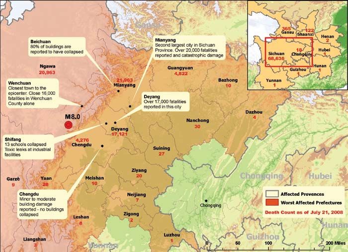
Table of contents

1 Setting and Damage of the Wenchuan Earthquake       1
1.1 Western Sichuan, Afternoon of May 12, 2008        1
1.2 Tectonic Setting                                  2
1.3 Property Damage: Surveys and Observations         2
     Proper Seismic Design and Risk Mitigation        4
     Effects of Long Duration Ground Motion           4
     Poor Building Configuration                      4
     Impact on Industrial Buildings                   5
     Vulnerability of Schools and Hospitals           5
     Vulnerability and Age of Buildings               5

2 Modeling the Wenchuan Earthquake                    8
2.1 Deriving a Modeled Loss                           8
2.2 Loss Estimates                                    8
2.3 Use of Modeled Results                            9

3 Improving Modeling By Incorporating Observations   11
3.1 Location, Location …                             11
3.2 Why Did This One Collapse?                       11
3.3 Data Quality—Where to Begin?                     12

4 Conclusions                                        14

                                                      I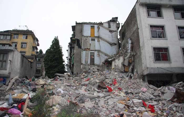
Foreword 前言
The magnitude 8.0 Wenchuan Earthquake of May 12, that it is a key player in preparing the country for the
2008 had the largest impact of any earthquake to strike next event. CIRC responded to the event by hastening
China since the catastrophic 1976 Tangshan Earthquake. the plans toward a natural hazard insurance scheme. The
The response of the Chinese people was worthy of the experience from other countries has shown that the first
size of the event: the Chinese government responded with step in building a natural hazard insurance scheme is to
rapidity and strength, sending troops to the affected areas, implement a consistent and robust data standard through
no matter how remote, to save lives from under the rubble which to report the value and the nature of the assets
and provide relief to those displaced or made homeless exposed. In the last week of May 2008, CIRC held a
by the earthquake. Individuals from all corners of China seminar to advance the development of these standards.
traveled to the affected region to offer help, or sent financial In this report, RMS has teamed up with the Institute
aid to the distressed. Today, close to six months after the of Engineering Mechanics (IEM), our partners in China,
earthquake, the wounds are slowly healing and the people to elaborate our response to the earthquake. The brief
of Sichuan are embracing the challenge of rebuilding their description of the impact of the event leads to some
cities better and stronger. In Beijing, and in government clear conclusions that support the advantages of a robust
offices across the country, the earthquake served as a harsh risk management culture, with the first step represented
reminder that the great steps China has taken in the past by investment in the definition and collection of data
decades have not sheltered the nation from the force and about the insured assets, supported by the standards
devastation of natural catastrophes, motivating another being established by CIRC. Alongside the academic
type of response—increased risk mitigation. Officials community, modeling companies also take away valuable
have been rehearsing emergency plans should the next lessons from analyzing how buildings and people are
earthquake happen in their city, in their town. In the office affected by earthquakes, and future models will reflect
towers of the financial districts, the banks and insurance this knowledge.This heightened awareness of the value of
companies, relieved that their exposure to the event was risk management is a precious opportunity to strengthen
small, have been offering financial assistance to hasten the the dialogue between the insurance and the modeling
recovery. In the boardrooms, however, questions have communities to work toward solutions to include risk
been raised: What if the next one is a direct hit to the metrics into the decision process. The opportunity
economic sector? What is the largest loss we can manage? is also at hand to leverage the strength of models to
The China Insurance Regulatory Commission encourage mitigation, and reduce the losses from future
(CIRC), the insurance regulator for China, recognizes earthquakes in China.
2008年5月12日发生在汶川的里氏8.0级地震是自 防灾减灾阵营中的重要一员。中国保监会应对巨灾的
1976年唐山大地震之后发生在中国境内的特大地震。 策略是竭力促成巨灾保险架构的形成。从多国的经验来
灾后,中国人民的救灾行动更是规模具大,史无前 看,建立巨灾保险架构的第一步是建立一个统一而强劲
例。中国政府反应快速,行动有力,在最短时间内向 的数据标准,来报告资产暴露的真正价值与实质。今年
灾区派遣了大批部队以拯救废墟下的幸存者,并妥善 5月底,中国保监会就已组织了研讨会来促进这个标准
安置受灾群众。灾后六个月的今天,地震的伤口正在 的建立。
慢慢愈合,四川人民正迎接重建的挑战,建设更好、 在这份报告中,阿姆斯风险管理公司与工程力学所-
更加坚固的家园。在北京以及全国各地的政府办公室 -我们在华合作伙伴一起详尽阐述了我们就汶川地震的
中,汶川大地震正成为一个警示,一方面提醒人们中 回应。这次汶川地震的影响揭示了一个清晰的结论,
国前几年的大举措并没有能使国家免受自然灾害的侵 就是要建立一个强劲风险管理机制的前题是加强保险
害,另一方面也激励着新的防灾减灾措施的出台。各 资产数据的采集与清晰度上的投入,这与保监会所要建
地政府官员也着手演练紧急救灾计划,为可能发生在 立的标准是统一的。与学术界一样,风险建模公司也从
自己城市的灾害作准备。同时,在金融区的办公大楼 分析建筑物与人在受到地震影响后的反应中学到重要的
里,银行与保险公司一边为他们的风险暴露在震区规 一课。从而,未来的风险模型将反映出这次所积累的知
模较小而庆幸,一边在为加快灾区重建提供经济上的 识。这次地震后对风险管理价值认识的提高,为加强保
帮助。在董事会议中,人们关心的问题是如果下一个 险公司与风险建模公司之间的对话,从而合作解决在决
灾害将直击中国的经济中心,我们到底能承受多大的 策过程中运用风险机制的问题提供了一个黄金契机。这
经济损失? 个机会同时也即将使风险模型在今后的地震减灾和降低
作为中国保险监督机构,中国保监会正成为公认的 损失中发挥重大作用。
II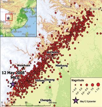
1 Setting and Damage of the Wenchuan
Earthquake
1.1 Western Sichuan, Afternoon of
May 12, 2008
The magnitude (M) 8.0 earthquake that struck Sichuan
Province on May 12, 2008 was the strongest earthquake
to occur in China in over 50 years, and caused the
largest loss of life since the Tangshan earthquake killed
242,000 people in 1976. The earthquake occurred in
Wenchuan County, a rural and mountainous region in
western Sichuan Province, around 50 miles (80 km)
west-northwest of Chengdu.
Based on field reports, the epicenter region
experienced extreme shaking of intensity IX–XI on
the Chinese Intensity Scale, capable of causing heavy to
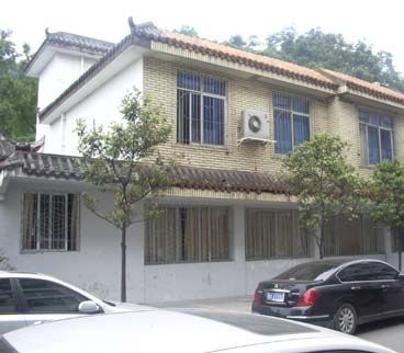
very heavy damage. Due to the mountainous terrain, Damage to buildings in Wenchuan (Source: IEM)
numerous landslides destroyed roads and blocked access
to the affected region, making search and rescue efforts
with no access to medical aid, food, or water. The
painstakingly slow. It wasn’t until rescue workers and
official death toll indicates that close to 70,000 people
emergency services were able to gain access to all of
died, approximately 18,000 are still missing, and almost
the damage-stricken areas eight days after the event that
375,000 were injured during the earthquake.
the true extent and severity of the earthquake emerged,
The Wenchuan Earthquake occurred at 2:28 p.m.
revealing a catastrophic disaster. The slow progress of
local time on Monday, May 12—a time when the
search and rescue efforts compounded the death toll, as
majority of adults were at work and children were at
many people were trapped beneath collapsed buildings
school. Though there is no official number published to
date, reports indicate that at least 10,000 school children
perished when approximately 100 schools collapsed. The
collapse of so many schools and the deaths of so many
children was one of the most disturbing consequences
of the earthquake, and parents and communities are
demanding answers and inquiries regarding the quality
of construction for school buildings.
Over 138,000 businesses were damaged during the
earthquake, leading to extensive business interruption.
Damage to energy production facilities caused power
outages across the affected region and continues to cause
disruption to the energy sector today.
As of September 8, more than 28,000 aftershocks
were recorded, of which 156 were recorded as M4 or
greater, 39 as M5 or greater, and 8 as greater than M6,
with the largest aftershock of M6.5 occurring on Sunday,
May 25. These strong aftershocks contributed to the
collapse of many of the buildings damaged during the
Location of the May 12, 2008 Wenchuan Earthquake epicenter and associated
main quake, causing further loss of life.
aftershocks (Catalog source: Harvard University)
1 M8.0 represents surface wave magnitude (Ms), the national standard used by the Chinese government for earthquake magnitude.The USGS reports M7.9 for the Wenchuan
Earthquake, which represents moment magnitude (Mw).
2 For more information, see the RMS report,The 1976 Great Tangshan Earthquake: 30-Year Retrospective: http://www.rms.com/Publications/1976Tangshan.pdf
1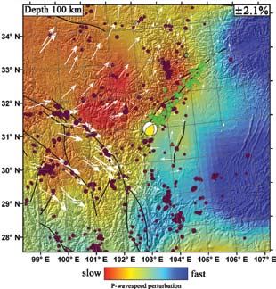
1.3 Property Damage: Surveys and
Observations
The Wenchuan Earthquake exhibited an extremely high
intensity with sustained impact over a large area. The
affected area includes the provinces of Sichuan, Gansu,
Shaanxi, and the Chongqing Municipal area—comprising
in total 417 counties in 16 provinces and municipals with
an area of more than 440,000 square kilometers and a
population of 45.61 million—a region so large that close
to half of China was impacted. More than 15 million
housing units collapsed during the earthquake and
resulted in direct losses to buildings and infrastructure
of over US$150 billion.
The event impacted the development of the planned
economic zone on the edge of the Chengdu-Chongqing
area, a region poised to become the biggest city cluster
in western China and aiming to become another regional
economic powerhouse like the Yangtze River Delta, Pearl
River Delta, and the Bohai Bay Region.
The Chinese Intensity Scale contour map depicting
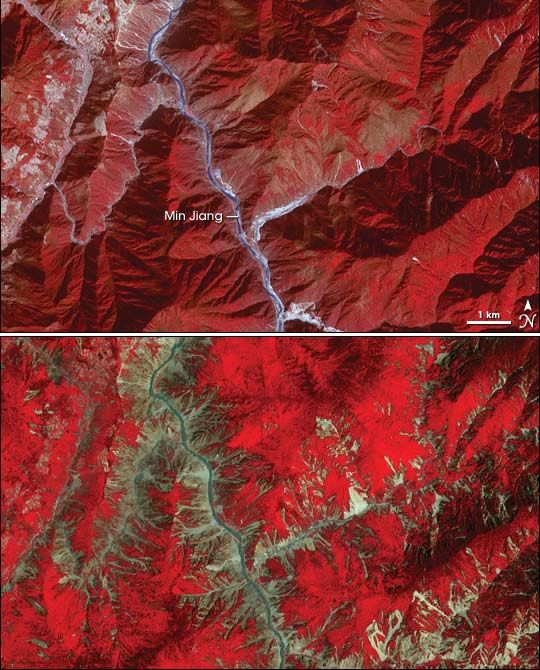
Map of the Longmen Shan fault system (black lines) depicting the direction shaking levels in the region illustrates that there are
of plate motion (white arrows); as well as the Wenchuan Earthquake epicenter
(yellow/white sphere); the rupture zone extending northeast from the epicenter; a number of large cities affected, including Chengdu
and aftershocks (green circles) (Source: MIT) and Xi’an as well as a number of medium-sized cities,
such as Dujiangyan, Mianyang, and Deyang, where
the damage was more severe. The area is known to be
1.2 Tectonic Setting rich in both cultural and natural resources, and the
The M8.0 Wenchuan Earthquake occurred on the Longmen recent earthquake not only destroyed many artifacts
Shan fault system in a mountainous region to the northwest of cultural heritage but impacted the region’s natural
of Chengdu, at the eastern margin of the Tibetan Plateau, heritage as well, as quake-induced landslides scarred
resulting from motion on a northeast-striking reverse fault many beautiful landscapes. The city of Dujiangyan has
(also known as a thrust fault) along the northwestern margin been an attraction known around the world for its
of the Sichuan Basin. The earthquake occurred along a famous dike, built over two thousand years ago, as well
240 km rupture zone extending northeast from the epicenter as its picturesque scenery. The severe shaking levels of
with a maximum estimated slip of 9–12 m. Chinese Intensity IX caused by the quake inflicted
The rupture represents the release of slowly building
tectonic stresses generated by the convergence of crustal
material from the Tibetan Plateau to the west with the strong
crust of the Sichuan Basin and southeastern China. This
region is roughly coincident with the position of a Mesozoic
collisional plate margin that developed during the closure of
the Paleo-Tethys Ocean during the Late Triassic Indosinian
Orogeny (approximately 230–200 million years ago) and
continued into the Late Cretaceous (Densmore et al., 2007,
Burchfiel et al., 1995). The crustal shortening caused by
the collision was initially accommodated largely on the
Wenchuan-Maowen and Beichuan faults but later migrated
southeastward onto the Pengguan Fault, which forms the
Longmen Shan fault system. Although the rate of slip along
the eastern margin is low, at about 1–3 mm/yr, this region
has the potential to generate large magnitude events due to
accumulation over long time periods.
Official Chinese Intensity Map (Source: IEM)
2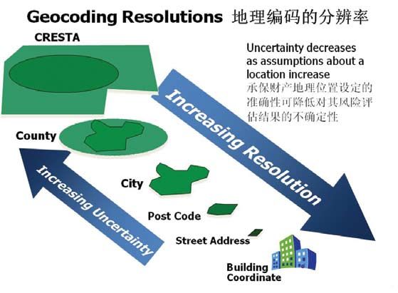
Distribution of casualties from the Wenchuan Earthquake, showing affected provences and worst-affected prefectures as of July 21, 2008 (Casualty numbers from SINA)

extensive damage on the city and the surrounding                                        Mianzhu, Pengzhou, and Shifang. In these cities the
landscape. The Zipingpu dam, located on the Min                                         buildings that were not designed and built with
River near Dujiangyan, endured severe shaking from                                      sufficient provisions to resist earthquake shaking
the earthquake resulting in a settlement at the center                                  suffered varying degrees of damage. A survey of
of dam at around 74 cm. Although the observed peak                                      Dujiangyan shows that close to 10% of multi-story
acceleration on top of the dam well exceeded 1 g,                                       reinforced concrete buildings collapsed or were
there was only slight damage to the concrete slab and                                   heavily damaged during the earthquake. Chengdu,
to the joints along the dam.                                                            the capital city of Sichuan Province, was sufficiently
    The damage experienced by structures in the                                         distant from the epicenter to only experience small
Wenchuan Earthquake was largely dependent on                                            shaking intensity, and thus the damage to buildings in
construction type. In the mountainous rural areas,                                      Chengdu was minor.
most of the buildings are one to two-story masonry                                          To assess and model the losses from the Wenchuan
structures composed of bricks or concrete blocks that                                   Earthquake, RMS employs a number of resources,
do not contain reinforced concrete elements. These                                      including firsthand accounts and damage surveys
structures are highly vulnerable to earthquakes, and                                    from the Institute of Engineering Mechanics (IEM),
consequently, many collapsed. In the larger towns                                       the government agency responsible for assessing the
in the mountain valleys, including Beichuan and                                         aftermath of the earthquake in affected areas. The
Wenchuan, multi-story buildings form the majority                                       IEM is RMS’ development partner in China and co-
of the building stock. The form of construction                                         developer of the RMS® China Earthquake Model.
of these buildings is typically reinforced concrete,                                    RMS staff also conducted earthquake reconnaissance
but three or four-story masonry buildings are not                                       in conjunction with the U.K.-based Earthquake
uncommon. A similar building stock makes up the                                         Engineering Field Investigation Team (EEFIT), which
towns and cities at the foothills of the mountains on                                   was one of the first foreign teams to visit the
the edge of the Chengdu plain, such as Dujiangyan,                                      epicentral area.

                                                                                                                                                                      3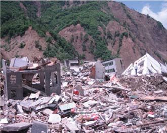
the enforcement of seismic building codes and proper
     80%
                     Brick
                                                                                      construction practices as the first and most effective
     70%
                     Framed 1st Floor
                                                                                      means to reduce casualties and losses due to earthquakes,
     60%                                                                              no matter how exceptional the earthquake may be.
                     RC Framed
     50%
                                                                                      Effects of Long Duration Ground Motion
     40%
                                                                                      Ground motion observations from the earthquake indicate a
     30%
                                                                                      long duration of ground shaking—over 100 seconds in most
     20%
                                                                                      areas, and in rare cases as high as a few hundred seconds.
     10%                                                                              The long duration of ground motion is a challenging issue
      0%                                                                              in earthquake engineering because of its continuous impact,
             Collapse        Heavy   Medium        Slight      None                   accumulating the damaging effects and compounding the
                                                                                      development of fractures within engineering structures.
Performance of different structures in Dujiangyan during the earthquake               As seismic waves travel through the ground, they produce
(Source: IEM)
                                                                                      both vertical and horizontal ground shaking effects, which
                                                                                      have different structural impacts that must be accounted
    As there are numerous public reports available                                   for in building design. Earthquakes typically have a larger
that discuss the performance of both buildings and                                    horizontal component of shaking compared to the vertical,
infrastructure during the Wenchuan Earthquake, this                                   and building codes are established to reflect this—but at
report does not present the full and detailed findings of                             some locations the Wenchuan Earthquake exhibited the
the surveys. The key observations that follow provide a                               opposite effect, generating a larger vertical component of
general overview of the impact of the earthquake on the                               shaking compared to the horizontal component. This poses
region’s building stock.                                                              another challenge in seismic design because in the current
                                                                                      Chinese design code, the maximum vertical component is
Proper Seismic Design and Risk Mitigation                                             stipulated to be less than two-thirds of the corresponding
In the aftermath of the earthquake, it became evident                                 horizontal components. The vertical component of shaking
that the buildings properly designed for earthquake                                   adds to the gravity loading to increase the demand on
resistance performed better than those that did not                                   the building’s structure. During an earthquake, when
adhere to the building codes. In particular, a significant                            the building is experiencing unusually high horizontal
number of buildings suffered only slight damage in areas                              loading, this additional vertical loading exacerbates the
that experienced shaking levels of VIII and above on                                  potential damage.
the Chinese Intensity Scale. The buildings still standing
                                                                                      Poor Building Configuration
to date in Beichuan are a testament to this. The design
intensity level established by the building code in most                              Many of the buildings collapsed because they were of
of the epicentral region before the earthquake was VII,                               soft story configuration—reinforced concrete moment
implying that these buildings were able to resist shaking                             resisting frames with masonry infill, where the ground
greater than what they were designed for. This sends a                                floor is cleared of walls to make space for commercial
strong message in support for seismic design: even under                              purposes or car parking. Reducing the number of walls on
large shaking, buildings that have been designed and built                            the ground floor is a flaw in the configuration design of a
with full consideration of seismic loadings will inherently                           building in respect to its ability to resist the earthquake’s
be safer buildings than those where little consideration                              horizontal forces. When the stiffness provided by the
is given. A building with a configuration of plan and                                 walls at the upper floors is removed at the ground floor,
elevation that avoids concentrations of horizontal loading,                           the remaining columns and beams at this level experience
and the size and strength of the structural elements to                               a severe concentration of loading, and failure of these
deal with horizontal loads, has a good chance of resisting                            structural members at the joints is a common cause of
seismic shaking even in excess of the levels it was                                   collapse. This poor consideration of seismic forces in the
originally designed for. These findings further support                               design and use of reinforced concrete-framed buildings

3 A selection of additional reports on the Wenchuan Earthquake is available from the following organizations: Earthquake Engineering Field Investigation Team: http://
www.istructe.org/eefit/files/Wenchuan_Preliminary_Report.pdf ; Earthquake Engineering Research Institute: http://www.eeri.org/site/content/view/358/35/; MCEER:
http://mceer.buffalo.edu/infoService/disasters/china-earthquake-sichuan.asp; National Center for Research on Earthquake Engineering: http://mceer.buffalo.edu/
infoService/disasters/china-earthquake-sichuan.asp
Vulnerability of Schools and Hospitals
The collapse of so many schools and the deaths of so many
children was one of the most disturbing consequences
of the earthquake. Though there is no official number
published to date, reports indicate that approximately
100 schools collapsed, killing at least 10,000 school
children. School buildings and hospital structures are
expected to conform to building design standards that
are higher than design codes for standard residential and
office buildings, and thus the collapse of such a large
number of these buildings has been a major factor in
pushing the Chinese government to move quickly to
assess the earthquake resistance of existing schools and
hospitals in other seismically active parts of the country.
Vulnerability and Age of Buildings
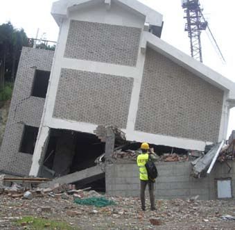
Soft-story failure of a six-story reinforced concrete residential building in The early results from the survey indicate that the
Dujiangyan (Source: EEFIT)
older reinforced concrete buildings were generally
more susceptible to damage from ground shaking. The
is not new and has caused a large number of casualties reasons for this lie both in the continued improvement
in recent earthquakes, the 1999 Kocaeli Earthquake of building construction standards and quality, and in the
in Turkey and the 2001 Gujarat Earthquake in India more stringent seismic requirements in the more recent
being clear examples of this. The vulnerability of these building codes.
structures has been further proven in this earthquake,
increasing the concern for the safety for the large
number of existing similar building in earthquake zones,
and the call for soft story configurations to be strongly
disincentivized in any new building project.
Impact on Industrial Buildings
Because the larger industrial centers in Chengdu were
nearly 100 km away from the epicenter, few buildings
with industrial production facilities were located in the
immediate footprint of the greatest shaking. Individual
examples of damage were observed, but did not significantly
impact the overall production in the region.
Partially collapsed five-story unreinforced masonry school building inYing-Xiu
(Source: EEFIT)
Landslides
Wherever major earthquakes occur in mountainous areas large landslides are triggered, filling valleys and
damming rivers. The Wenchuan Earthquake triggered numerous landslides and rockslides. The damage caused
by these landslides occurred on numerous levels.
Firstly, environmental damage was caused as the landslides permanently changed the landscape, damaging or
possibly even destroying vulnerable ecological networks. Secondly, direct physical damage to buildings, vehicles,
and infrastructure was caused by failing slopes or falling debris. The toll on humans was evident as many people
were buried or crushed by the landslides.
Lastly, the landslides caused a significant amount of indirect damage. Damaged businesses suffered not only
losses due to physical damage, but also losses sustained from business interruption. Blocked and damaged roads
disrupted transportation to affected areas, isolating communities, hampering relief efforts and cutting off much-
needed supplies. Landslides caused significant damage to infrastructure—including road networks, communications
equipment, and power stations—leading to downed communications and power outages.
February 19, 2003
May 23, 2008
Beichuan County: Landslides are responsible for a large proportion of the damage. Satellite images illustrate landslide damage
triggered by the earthquake near the city of Mianyang: before (top) and after (bottom) (Source: NASA)
Quake Lakes
Landslides triggered by earthquakes
can send debris into riverbeds,
potentially blocking and damming the
river. Massive amounts of water pool
at a high rate behind the earthen dam,
creating a so-called “quake lake”—a
landslide-induced reservoir—that can
often become a permanent feature of
the landscape.
The threat from quake lakes occurs
both upstream and downstream.
Flooding upstream occurs as the
river pools behind the blockage,
inundating settlements located on
the riverbanks. For a majority of
earthquake dams, water permeates
through the landslide material or the
slide begins to erode slowly once it is
overtopped. However, in a minority
of cases, the erosion or collapse of
the dam is catastrophic. The collapse
of the Deixi landslide dam on the
Min River in China in 1933 ultimately
flooded 250 km of the river valley,
killing more than 2,400 people.
The 2008 Wenchuan Earthquake
created 35 landslide-induced quake
lakes4, 34 in Sichuan Province
alone, forcing evacuations in some
villages downstream of the affected
rivers. As of July 17, 31 of the 34
quake lakes in Sichuan had been
stabilized5. Beichuan County, near the
epicenter, was particularly affected
by quake lakes, the largest being
the Tangjiashan quake lake. The
lake was originally highly unstable,
threatening 1.3 million people
downstream, and necessitating the
evacuation of 250,000 people from
the city of Mianyang as authorities
worked to stabilize the dam. The
lake was stabilized in early June,
and plans to build a hydropower
station or to develop the lake as a
scenic area in an effort to rebuild
the earthquake-devastated Beichuan
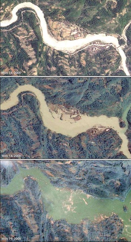
Creation ofYansai Lake in Beichuan County: Normal springtime conditions, May 14, 2006 (top); two days after theWenchuan
Earthquake, May, 14 2008 (middle); one week after quake, May 19, 2008 (bottom) (Source: National Space Organization ) County are under consideration.
4 Source: Embassy of the People’s Republic of China in the United States: http://www.china-embassy.org/eng/gyzg/t458627.htm
5 Source:World Heath Organization: www.wpro.who.int/sites/eha/disasters/emergency_reports/chn_earthquake_latest.htm2 Modeling the Wenchuan Earthquake
Next, the portfolio of properties affected by the
Catastrophe Modeling Fundamentals earthquake is retrieved from an economic exposure
Catastrophe models quantify the likelihood of disasters database of replacement values. Location, along with other
occurring and estimate the extent of incurred losses, factors that describe the property, such as construction
both from single events and multiple events averaged and occupancy type, and building height and age, are
over a year. The four basic components of a catastrophe used to characterize the inventory. The model then uses
model are hazard, exposure, vulnerability, and loss6:
both the typical hazard for that resolution and the average
Hazard: characterizes the event itself using vulnerability for that county for loss calculations.
parameters such as epicenter and magnitude
Based on this measure of vulnerability, the hazard
for earthquakes
and inventory components of the model enable the
Exposure: defines the individual properties calculation of loss, a quantification of the physical impact
at risk by their location and value/coverage of the natural hazard phenomenon on the structures and
Vulnerability: calculates the physical individuals at risk. Finally, the direct and indirect losses
damage from the event to each property in to the inventory are quantified. Direct losses include the
the inventory cost to repair and/or replace a structure. Once total
Financial (loss): translates the physical losses are calculated, estimates of insured losses are
damage into a monetary loss estimate computed by applying policy conditions (e.g., coverage
deductibles and limits) to the total loss estimates.
Catastrophe models simulate the impact of historical
An inventory can also consider human populations at
events as well as tens of thousands of possible event, or
stochastic events, allowing a probabilistic view of risk. risk. The location of individuals throughout a given day
(e.g., home at night, at work or school during the day,
or en route between work and home) is an important
2.1 Deriving a Modeled Loss
indicator of risk, as casualties vary significantly according
In the wake of a devastating event such as a major to a population’s location at a particular time of day. The
earthquake, it is important to obtain a timely estimate Wenchuan Earthquake occurred in the middle of the
of potential losses. Catastrophe models are integral tools day, and as a result a disproportionate number of school
for assessing both the potential economic and insured children died when numerous school buildings collapsed
losses from catastrophic events. during the earthquake.
To replicate the Wenchuan Earthquake, the event was
characterized by its epicenter, magnitude, and depth, as 2.2 Loss Estimates
well as by relevant hazard parameters in the model that Immediately after the Wenchuan Earthquake, RMS
most closely correspond to the actual event. estimated that the economic property losses resulting
The hazard component also comprises information from the event would range between US$10 and $15
regarding attenuation—the decay of ground motion billion. This figure includes insured and non-insured
intensity with distance from the event source—and damage to property structures and contents, but does
geotechnical hazard, such as soil type and landslide not account for losses that may have occurred as a result
and liquefaction susceptibility. When the analysis is of business interruption, or wider economic effects such
performed, the model retrieves the geotechnical data as infrastructure damage. At the time, casualty figures
for the earthquake footprint from a variable resolution were evaluated to be between 18,000 and 34,000. As
grid (VRG)—a proprietary RMS geographic indexing more information on the extent of damage and casualties
system. The model also calculates the amplification of became available through reconnaissance missions and
ground motions caused by the different soil types that media reports, it became clear that these preliminary
underlie exposure—certain soil types can exacerbate a estimations were too low.
quake’s shaking effects, leading to differing degrees of A key reason for this undervaluation is that the
observed damage, an effect particularly evident during proportion of low-performance rural and old structures
the Wenchuan Earthquake. in the overall building inventory for the affected region
6 For more information on modeling earthquake risk in China, see the RMS report, Creating a Technical Foundation for Earthquake Insurance in China:
https://www.rms.com/Publications/ChinaStudy_Final.pdf
was underestimated. The poor performance of these                                         2.3 Use of Modeled Results
vulnerable structures severely impacted the number of
the casualties as well as the damage level. Another reason                                Catastrophe models can be used for risk management in
for the underestimation is the low geographic resolution                                  a number of ways. Under everyday circumstances, the
at which the inventory was assessed. Currently the                                        quantitative loss metrics produced from the model can
inventory data used for the estimate is only at the county                                be used to quantify risks and determine the appropriate
level—but, as seen from the earthquake damage, there                                      design levels for earthquake resistance, as well as to devise
is a vast difference among villages within a county,                                      strategies for mitigation, such as insurance, reinsurance,
especially in the areas close to the rupturing fault. The                                 and catastrophe bonds. Following a catastrophic event,
third reason is the compounding effect of geotechnical                                    parameters describing the magnitude and location can be
damage, such as that from landslides. Geotechnical                                        entered in the model to estimate the potential economic
failure not only magnifies the damage to infrastructure,                                  and insured losses and casualties from the event. The
but also causes direct damage to buildings.                                               distribution of damage and casualty can also be used for
    Although only a fraction of the property loss will be                                 effective dispatching of emergency personnel and relief
borne by the insurance industry, this earthquake is still                                 efforts, as they indicate the areas most impacted, where
likely to cause the highest insured losses in the country to                              emergency relief is needed most.
date. Insurance penetration varies significantly by line of                                   Catastrophe models are widely used in the insurance
business, ranging from negligible for residential property,                               industry. Models inform the pricing and underwriting
to approximately 50% for high-end commercial buildings                                    of insurance policies, and help in managing portfolio
in Chengdu, and full coverage for the industrial facilities                               aggregations. With the advent of catastrophe bonds,
owned by multinational companies. Additionally, business                                  the capital markets have become increasingly active
continuity is a fundamental issue, as the areas affected are                              in using catastrophe models for pricing and exposure
burgeoning manufacturing zones for hi-tech companies                                      management.
and a key resource for the energy industry. As of August                                      As mentioned previously, the use of models can extend
28, Chinese insurers had paid out nearly US$90 million                                    well beyond the insurance industry, with applications
in claims with an additional US$54.5 million in deposits                                  in areas including governmental policy decisions,
for future payout, according to the China Insurance                                       development agendas, and emergency planning and
Regulatory Committee (CIRC).                                                              response efforts. Immediately after the event, confirmed
                                                                                          fatalities were still in the few thousands. RMS’ initial

Probabilistic catastrophe models estimate the losses caused by earthquakes by establishing event parameters and assessing the exposure and hazard for a given location
addressed in the following section. Observations from
the Wenchuan Earthquake present excellent talking
points to explain the advances catastrophe modeling
has undergone to address the uncertainty in the
likelihood of any particular building experiencing
damage. Earthquakes never fail to intrigue some
observers as to why some buildings are reduced to a
pile of rubble while others stand strong and unscathed
by the quake. The engineering knowledge embedded
within the models strives to explain these observations,
and the exposure data entered into the model provides
access to this knowledge for each of the properties in
the portfolio.
Estimated mean damage ratio (MDR) distribution of the preliminary loss
estimate in Sichuan Province by district
economic and casualty loss estimates, $US10–15 billion
and 18,000–32,000 thousand casualties, respectively,
were presented to Premier Wen Jiabao through the IEM
and CEA, and contributed to the decision to immediately
deploy an additional 100,000 soldiers to the disaster area
for search and rescue efforts.
The previous sections have discussed how loss
estimates for the Wenchuan Earthquake could be
generated a few hours after the event using the RMS®
China Earthquake Model and in-house databases of
economic exposure developed by RMS during the
development of this probabilistic loss model. Model
results can also be used to consider how the experience
of events such as the Wenchuan Earthquake can
reinforce how insurance companies can be empowered
in their risk management decisions through the output
of catastrophe models. Observations from the event in
particular demonstrate that robust risk management
starts by capturing and managing exposure in a database
that accurately represents the location, replacement
value, and building attributes of the properties in an
insured portfolio.
The insurance industry is heavily dependent on
accurate exposure information. For responsible insurance
companies, several key pillars of risk management
underlie their governance and culture: pricing based
on real risk, identification and accumulation of exposed
risks, adequate capital allocation and solvency, and
robustness and transparency of information flow. All
of these imply the proper treatment, interpretation,
and presentation of data that represents the physical
properties and the insured value of the portfolio. Risk
quantification, related risk-based pricing, and the
contingency of data on the accuracy of the analytics are
103 Improving Modeling By
Incorporating OBservations
3.1 Location, Location … in each of the grid cells, which vary in size depending on
the severity of hazard or concentration of exposure in a
The effects of seismicity are highly dependent on region. For earthquake risk, grid resolution increases in
the soil or rock type upon which a structure is built. areas of high seismic risk to capture the differences in
Similar buildings, located in areas that experience risk at small distance increments for the most dangerous
similar levels of seismicity, can be subjected to very faults. Similarly, the grid is refined in cities where the
different degrees of shaking depending on the level of risk differential to high value exposures could have
amplification generated by the underlying soil (or rock). a large impact, as in Chengdu. The model maps the
For instance, in Dujiangyan, two 2–3 story reinforced exposure data onto this grid of cells by geocoding the
concrete frame residential buildings with masonry infill data. Geocoding is the process through which the model
performed differently during the earthquake because translates the verbal description of the address, or “local
they were built on different soil types. The building coordinates,” into “global coordinates” such as latitude
located on stiff soil (rock) at the northeast corner of and longitude or a common administrative boundary. In
Dujiangyan collapsed, while the building in the city China, the geocoding engine recognizes and matches a
center close to the river where the sub-surface soils are hazard value to locations entered at province, prefecture,
marine deposits was virtually undamaged. In this case, county/district, four and six digit postcode, city name,
building height also had an impact on performance— and location latitude and longitude levels of resolution.
low-rise buildings are particularly vulnerable on stiff With this information at hand about the insured portfolio,
ground conditions. Stiff soil and low-rise buildings have the model can reduce the uncertainty in results.
very similar vibrational periods, creating an add-on
effect where the building and ground shake in tandem 3.2 Why Did This One Collapse?
during the quake, greatly amplifying the shaking and, in
this case, leading to collapse. Among the tasks undertaken by survey engineers in
Catastrophe models capture these differences by the epicentral region is the assessment of the damage
analyzing the hazard for analysis locations at varying levels experienced by buildings and infrastructure. This
of resolution. The latest generation of RMS modeling knowledge travels through the academic community
tools leverages a technique known as variable resolution and is translated into models that differentiate the
grid (VRG) technology. Hazard analyses are carried out performance of different types of buildings. The pricing
Similar buildings performed differently during the earthquake due to the type of soil on which they were constructed: the building built on rock (left) collapsed, while the
building built on softer soil (right) was virtually undamaged. (Source: EEFIT)
11metrics that insurers calculate from the models for their 3.3 Data Quality—Where to Begin?
portfolios reflect these findings. What did the Wenchuan
Earthquake tell us about the most important piece of Exposure data travels through an insurance company
information we need to know about the insured property? throughout the cycle of the risk—from the point
Two buildings can display differing damage states of underwriting to the transfer on the international
despite their similarities: for example, two buildings markets. In the aftermath of an event, as discussed
constructed of reinforced concrete were located close above, observations confirm the difference in damage
enough together that the soil type upon which they were levels and financial loss to apparently similar properties.
built and the ground shaking they experienced were The value of understanding these differences clearly
similar. However, one building was severely damaged, adds value to the risk decision processes, and can give
while the other appears undamaged. Though many other significant competitive edge. The advantages of quality
construction factors could have influenced this outcome, exposure data describing the location and attributes of
one dominant attribute that differentiates the buildings is insured exposure extend beyond the ability to generate
the year in which they were built. Better understanding more accurate risk quantification using a loss model. The
of the material and construction methods has, as a whole, importance of exposure data is realized throughout each
improved the quality and resistance to lateral forces of stage of the risk cycle:
reinforced concrete buildings. The building codes that Monitoring exposure concentration and
dictate how resistant a building should be to earthquakes accumulations, which might be geographic or in
are regularly updated and improved—in China, major certain occupancies
updates took place in 1978, 1990, and 2001. So is age the As a currency to report underwriting guidelines
most important attribute that describes the resistance, and across the company
therefore the seismic risk? The vast majority of buildings To output technical rates by location
that are likely to be insured in China are reinforced To improve the company’s standing among rating
concrete, and most of them are engineered to building agencies
codes. Age is therefore an important attribute as there will In price setting and determining availability of
on average be a close link between the age of a building, capacity
and its vulnerability to ground shaking.
Differences in damage levels due to building age in Dujiangyan:The older building (center), designed with no seismic code, collapsed, while the newer building (right),
designed to seismic code standards, remained intact (Source: IEM)
12Geographic levels of geocoding resolution used in RMS models
The Chinese Insurance Regulatory Commission
(CIRC) is working to develop a data standard that will
allow a single currency for insured exposure to be used
throughout the industry. Risks will be defined in terms
of the policy structures, replacement values, and types
of occupancy as well as specific physical attributes of
the buildings. Insurance companies with aspirations
for robust growth in China are encouraged to engage
in the definition of these standards and adapt their
systems to handle this new data. The benefits from the
implementation of the standards will soon be noticed
throughout the organization.
134 Conclusions
The Wenchuan Earthquake was the strongest and of China change the frequency and severity of the
most devastating earthquake to hit China in the past earthquakes assumed in the model?
thirty years. The shockwaves of the event will be felt How can we model the risk from landslides and the
for many years to come. Almost half of the population secondary loss impact these can have?
of China was impacted by the earthquake, and the Some of these questions may take several months
widespread destruction and loss of life will leave an to answer. IEM, who is responsible for surveying the
everlasting imprint on the landscape and the people of damage, only just completed their work in the field in
Sichuan Province. September 2008, and publication of ground motions is
In the aftermath of the event, it became evident that still pending. In discussing upgrades to the current RMS®
there were many commonalities in the levels of damage China Earthquake Model, originally released in 2007, it
experienced by buildings during the earthquake: is clear that one aspect deserving further research is the
Structures built to seismic design codes invariably maximum magnitude possible on each fault structure,
performed significantly better than those without and the impact the uncertainty of maximum magnitude
earthquake engineering has on the modeled results.
A building’s characteristics, such as age and location, Modeling companies have also acknowledged that
were found to be key determinants of a structure’s the insurance industry in China is set to become a
vulnerability to earthquakes driving force on the global scene and that the demands
An unexpectedly high proportion of schools and from this growth necessitate solutions that are bespoke
hospitals collapsed, causing a high fatality rate among and achievable within the challenges of rapid growth.
the more vulnerable population groups Encouraging dialogue, establishing a presence, and
Numerous soft-story configuration buildings collapsed listening to the risk management needs in China have
due to their weakened structure escalated to the top of the modeling companies’ strategy
The long duration of the ground motions experienced agendas. The establishment of an office in Beijing further
during the earthquake, as well as the unusually high strengthens RMS’ commitment to supporting the growth
vertical component of the shaking exacerbated the of the insurance industry in China.
damage caused by the earthquake
In the wake of an event, catastrophe models are
integral tools for assisting governments and the insurance
and reinsurance industries in assessing the potential losses
from the event. The Wenchuan Earthquake highlighted
the importance of data quality in estimating these
potential losses. Two characteristics in particular were
found to play key roles during the earthquake: location,
which affects the level of shaking, and building age,
which can be closely correlated to resistance to shaking
offered by the seismic design level.
Large devastating events such as the Wenchuan
Earthquake send tremors far beyond the area affected
by ground shaking. Modeling companies have the duty
to respond to such events and revisit the science and
assumptions that underlie the results to the loss models.
There is still uncertainty around many of the finer
details of the event that contribute the most valuable
learning points:
What do the ground motion recordings say about the
attenuation assumptions?
Does the detailed damage survey validate the
vulnerability functions?
How will any revision to the seismic hazard map
14FOCUS: Energy Disruption7
The disruption of a nation’s power supply impacts the economy in many ways, including interrupting business
activity, the cost of which is likely to be borne by insurers. How bad could the business interruption cost be from
power outages or damage to the power infrastructure? The implications of the Wenchuan Earthquake extend over
all sectors of the energy industry in Sichuan:
Hydropower
Hydropower provides more than 20% of China’s total installed energy capacity. China’s ambitous energy
targets have this number doubling by 2020, and Sichuan Province is one of China’s key development regions
for growth. Before the earthquake, hydroelectric dams in the region generated 62% of Sichuan’s total energy
production. However, hydropower operations in Sichuan Province were hit hard by the earthquake: up to 481
dams (803 nationwide), and many power stations along the river systems were badly damaged. Two weeks
after the quake, 69 reservoirs were on the verge of collapse, and 310 reservoirs were in “highly dangerous”
conditions. Several major reservoirs were drained as emergency measures to prevent their dams from failing.
Wind Turbines
Dongfang Turbine, in Sichuan Province, is China’s largest steam turbine producer and the third largest domestic
manufacturer of wind turbines. Dongfang suffered severe damage during the earthquake, seriously impacting
the production and selling of wind turbines domestically and globally. Dongfang estimates that direct losses from
the quake will reach US$1 billion—indirect losses from factors such as business interruption and the impact on
the global economy are more difficult to quantify.
Natural Gas
Natural gas currently accounts for only 3% of the national energy mix, and prior to the Wenchuan
Earthquake Sichuan was to play a key role in increasing this percentage to 10% by 2020. In 2007, Sichuan
Province supplied 27% of the country’s natural gas production. While the Wenchuan Earthquake caused
some damage to natural gas exploration and production facilities, overall, the effect of the earthquake on
the natural gas industry is not expected to be severe. Once reconstruction efforts are completed, China is
expected to return to full production.
Nuclear Power
China has ambitious nuclear development plans that have many provinces vying to participate—Sichuan Province
was intending to begin construction on a new nuclear plant in 2010. However, the danger of having a nuclear plant
in an earthquake-prone region has prompted a rethinking of China’s nuclear development agenda. Officials reported
that several facilities in Sichuan were damaged; however, there has been no mention of any radioactive leaks.
On the whole, experts believe the overall impact of the Wenchuan Earthquake on China’s energy production
will be relatively minor due to the country’s capacity to supplement energy shortages from damaged hydroelectric
facilities by increasing usage of the less affected energy sources, such as oil, natural gas, and particularly coal,
while hydropower facilities are repaired. This method, however, puts a greater toll on the environment and drains
precious natural resources.
The earthquake’s greatest impact on the energy sector will be to China’s ambitious long-term energy
development plans. China will need to examine how these elaborate plans—particularly the resources needed
to implement them—coincide with the country’s risk from natural hazards. History has shown us that building
numerous large hydropower dams or nuclear facilities in a region with high seismicity can be a disaster waiting
to happen.
7 The information in this section has been compiled from the following sources: “China Quake Batters Energy Industry,” BusinessWeek: http://www.businessweek.com/global-
biz/content/may2008/gb20080519_901796.htm; “China’s Renewable Energy Plans: Shaken, Not Stirred,” Energy Bulletin: http://www.energybulletin.net/node/45778;
“Quake Lakes Under Control: Situation Grim,” Embassy of the People’s Republic of China in the U.S.A.: http://www.china-embassy.org/eng/gyzg/t458627.htm; “Energy
Implications of the 2008 Sichuan Earthquake,” Global Terrorism Analysis: http://www.jamestown.org/terrorism/news/article.php?articleid=2374284
15Risk Management
S ol u t i on s, I n c.
7015 Gateway Blvd.
Newark, CA 94560
USA
Tel 1.510.505.2500
Fax 1.510.505.2501
Tel 44.20.7444.7600 (Europe)
RMSChina
#208-11 Winland International Finance Center
No. 7 Financial Street
Xicheng District, Beijing
北京市西城区金融街7号
英蓝国际金融中心 208-11 室
China
Wo r l d W i d e W e b Tel 86.10.5833.2255
http://www.rms.com
E - m a i l
info@ rms.com
© 2008 Risk Management Solutions, Inc. All rights reserved. RMS and the RMS logo are registered trademarks of Risk Management Solutions, Inc. All other trademarks are
property of their respective owners.You can also read