The Contribution of the Urbanization of the Information System on Urban Development in Casablanca (Morocco) - Horizon Research Publishing
←
→
Page content transcription
If your browser does not render page correctly, please read the page content below
Civil Engineering and Architecture 8(3): 366-370, 2020                                                        http://www.hrpub.org
DOI: 10.13189/cea.2020.080321

              The Contribution of the Urbanization of the
              Information System on Urban Development
                      in Casablanca (Morocco)
                                           Mohamed Rtal*, Mostafa Hanoune

                              Laboratory TIM, FSBM, Hassan II University of Casablanca, Morocco

                             Received April 27, 2020; Revised May 21, 2020; Accepted June 23, 2020

Copyright ©2020 by authors, all rights reserved. Authors agree that this article remains permanently open access under
the terms of the Creative Commons Attribution License 4.0 International License

Abstract In order for development to be sustainable,                social facilities, environmental degradation, management
strong and rich, it must be established in a common vision          of urban space, traffic overlaps etc. Human urbanization
of all activities of society, so that each party decides and        policies have created a need for an urbanization of
chooses to form it in its own way. In this context, it was          information systems to control this phenomenon through
necessary to "have" a parallel roadmap for this concept of          the establishment of urban planning documents defining
human city planning, which is the strategic development of          the rules for the control of urban activities. The
information systems through the concept of city planning            urbanization of information systems is today positioned as
for an information system that should represent the                 a powerful decision-making tool, particularly with regard
contribution of the value of different citizens. Thus, the          to the management and control of space. The integration of
information system can be compared to the city area: If the         the spatial dimension, thanks to Geographic Information
latter is well built and well civilized, it is possible to raze a   Systems (GIS), now makes it possible to locate information
building in the heart of the area without jeopardizing the          and organize data more precisely. Certain procedures in the
entire sector, and replace it with or rebuild another building.     urban information system are based on standard
A study of the stages of this urban expansion would                 geographic documents. Thus the use of GIS is relevant for
provide the researcher and actor with a clear view of how           part of the work, especially urban.
the city was expanded, its directions, and its horizons, and           From 1781, when the Spanish installed counters there,
thus contribute to preparing and managing the urban area            that the Spanish translation, Casa Blanca, spread. European
of the city, and from the most effective means to do so, we         traders settled there and at the beginning of the 19th
find new technologies that have added a lot to studies              century, the French obtained from Sultan Moulay
Geographical        indications,    including      geographical     Abdelaziz (1894-1908) to build a port. Casablanca,
information systems and remote sensing, which are of great          considered the first port of Morocco from 1920, it also
importance, given the aerial photographs and archive data           became, in 1925, the first stopover of the Latécoère airlines
they provide.                                                       (the future Aéropostal) connecting Toulouse to Dakar
                                                                    [1-2].
Keywords         Information System,            Development,
                                                                       After the establishment of the Protectorate, Lyautey and
Casablanca, Urban Development
                                                                    his architect Henri Prost embark on the realization of the
                                                                    modern city center by building wide boulevards bordered
                                                                    by large and pretty buildings. It is in this city that the first
                                                                    factory will be built and that will be launched the first
1. Introduction                                                     union. In 1950, Casablanca was a dynamic shopping center
                                                                    whose urban planning was booming.
  Casablanca is experiencing a rapid increase in the urban             In the aftermath of independence, Casablanca became a
population due to population growth, rural exodus and               large urban concentration, which required control of its
several other social, economic, etc. parameters. This               pace of development. This was the subject of the Urban
urbanization, which introduces quite complex phenomena,             Development Master Plan drawn up in 1985.
has generated a multitude of problems: transport, lack of              The construction of the Hassan II mosque gave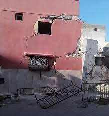
Civil Engineering and Architecture 8(3): 366-370, 2020 367
Casablanca a spiritual, religious and tourist dimension. for preserving geographic information linked to the nature
The major projects were launched by His Majesty King of places, monitoring all resources, analyzing them and
Mohammed VI who may God glorify him, since his defining models for them, while monitoring the effects of
enthronement aiming to further consolidate the efforts tourism development because it is a tool basic and applied
concerning the improvement of the living conditions of the to analysis, and a means that displays tourist and
citizen of Casablanca. archaeological sites in the form of geographical maps,
helping to provide all the information and data that support
tourism planning, such as:
2. Urban Vision in Question: Evolution Residential buildings: those with artistic or personal
and Challenges of the City value, such as the notables…
Social facilities: traditional schools, bathrooms
Casablanca Religious installations: mosques, corners, shrines and
The city of Casablanca has constituted an important cemeteries
cultural heritage with the mixture of many civilizations Tourist paths: paths and roads leading to the most
through the ages. This was reflected in its urban fabric, important monuments of the city through signs and
which made it regain a unique urban structure, but the latter special signs
has experienced in recent decades a kind of neglect and Casablanca, known as the "White City", is considered
deterioration, which has affected most of its urban facilities, one of the most active and vibrant cities in Morocco. In a
and this is mainly due to Economic, social and century, the humble village of Anfa managed to become a
demographic problems, and with the increase of this city with more than four million people to become one of
problem, a set of interventions and strategies had to be the largest cities in Africa.
undertaken in order to raise the standard of living of
buildings and roads with all their components economic,
social, cultural [3]. 4. The Problematic of the Study
For Casablanca to remain a witness to a deep past, the
urban policy of the city recently implemented an urban Casablanca occupies a key position on the Moroccan
vision of information systems, which have proven in many development map. Since the independence of Morocco and
areas their capacity to face the daily problems and its control of the city of Casablanca, the Kingdom of
challenges which are defined. Through the management of Morocco has worked hard to develop it through a number
urban areas. Information systems are considered to be an of development projects, and the country has started to
effective mechanism for integrating different types of prepare plans and studies for development. Provided that
information. The system includes software and devices that infrastructure projects start, especially in coastal areas,
allow the collection of information in a database, quality because it is a large region which suffers from a
control, updating of data, information and analysis (logic demographic explosion and problems at different levels:
and statistics) in a simple, fast and precise manner, with a political, administrative, sporting and cultural, this is
visual display of this data in the form of a map. extremely necessary with regard to the main problems of
housing and infrastructure. In terms of development plan,
urban master plan, zoning plan and finally the development
3. Information Systems and Their Role plan of information systems to supervise town planning.
This situation poses the following problem "How to use
in Protecting Heritage a functional information system to carry out an urban and
The case of heritage cities has become more urgent than advanced planning of the city of Casablanca with a
ever, because it has a very important cultural and historical strategic orientation with transverse administrative
value, because this heritage is the property of all humanity objects?"
[5-6]. The processes that must be accomplished to preserve
these heritage cities are mainly linked to the diagnosis and
implementation of projects for the different architectural 5. Threatened Housing is A Feature of
and urban components of these cities. If modern cities Most Areas of the Old City
depend in their urban planning on the use of modern
methods, then historical exploits with a complex and According to all the research and studies carried out in
distinct fabric with significant historical and cultural many old Moroccan cities, the phenomenon of housing
weight require the use of very sophisticated scientific threatening to collapse has become generalized, all the
techniques, capable of diagnosing and analyzing the more so since this type of housing is no longer limited to
current situation and to highlight forecasts and future one district and no other, but the phenomenon has become
scenarios, in a global rescue and rehabilitation approach. widespread in all districts and paths of ancient cities. The
Urbanization of information systems is an important tool best example of this is the old city of Casablanca, which
368      The Contribution of the Urbanization of the Information System on Urban Development the in Casablanca (Morocco)

has seen an increase in the deterioration of its built                         Mastering information has always been a major concern,
environment over the past 20 years, which has led to the                    at all levels and in particular that of power. This issue is
collapse of many houses, resulting in enormous loss of life                 essential, especially with regard to the management of
and goods.                                                                  heritage protection. The explosion of new technologies and
                                                                            information technology in all sectors of activity suggests an
                                                                            even faster development of global databases [10].
6. Geographical Distribution of                                                This approach begins with the inventory and
   Buildings Threatened with Collapse                                       capitalization of all the information in the Casablanca
                                                                            information system (databases, applications, services, etc.),
   in the Old City of Casablanca                                            while respecting its function, in order to rationalize and
   The spatial distribution of buildings at risk of collapse in             enhance human capital.
the old city of Casablanca is characterized by the variation                   Therefore, the objective of the urbanization approach is
in their total number from one region to another, and with                  to achieve the structure of the information system, which
different degrees of severity, the official data of the city of             improves its performance and scalability. It thus gives
Casablanca revealed that 6,338 buildings should be treated;                 Casablanca the means to develop its information system
of which 2,180 will be completely demolished, 956 will be                   with full knowledge of the causes [11-12].
partially demolished, while 2,921 buildings will be treated
and rehoused 9,250 families, stressing that 3,995 families                  7.1. The Role of Urbanization of Information Systems
have been permanently resettled, while a residential offer                       in the Diagnosis of the Physical State of Buildings
has been made to house 2,106 families, 6,100 families out
of 9,250 whose files have been processed. Figure 1 shows                       The classification of buildings at risk of collapse
some photos of buildings threatened with collapse in                        depends on a number of indicators, mainly the
Casablanca [7-9].                                                           "pathological" symptoms that appear on the structure of
                                                                            buildings vertically and horizontally. Several of these data
                                                                            are used to develop a classification of the degree of
                                                                            dangerous buildings, because they are classified into three
                                                                            levels of severity. The information system is used as a tool
                                                                            for this classification by collecting data directly in the field,
                                                                            through repeated visits to the field in order to diagnose it,
                                                                            and by creating a database, used to map, showing the
                                                                            distribution of the role which is threatened with collapse
                                                                            according to the degree of its gravity, on which to rely in
                                                                            most of the interventions undertaken by various institutions
                                                                            involved in the safeguarding of the ancient city.

                                                                            7.2. The Process of Urbanization of Information
                                                                                 Systems

Figure 1. Photo of buildings threatened with collapse by an old fabric in
Casablanca

7. Urban Expansion of Information
   Systems in Urban Rehabilitation and
   Upgrading Programs for Heritage
   Protection
   Nowadays, the management of a city encompasses vast
fields of competence. The population is in perpetual
growth, it follows from it the needs for new resources and
infrastructures growing. In addition, the process of
urbanization of Information Systems consists first of all in                  Figure 2. Principle of the urbanization of the Information System
studying the different functional sectors of Casablanca as
metropolitan city (production, management, sale, etc.), in                    The urbanization process aims to gradually improve the
order to be able to implement the mapping, then to study                    performance and management of the information system to
the information system in the same way.                                     make it a critical competitive advantage. For this,
Civil Engineering and Architecture 8(3): 366-370, 2020 369
urbanization depends on an essential tool - mapping -
thanks to which the company will have a clear, documented
and valued vision of its heritage.
The implementation of the mapping / urbanization
approach will allow us to build a prototype and
progressively responsive information system, able to better
serve corporate strategy.
Figure 2 shows the different Principles of urbanization
of the information system
7.3. The Urbanization Role of Information Systems in
The Preservation of Historic Monuments and
Sustainable Development
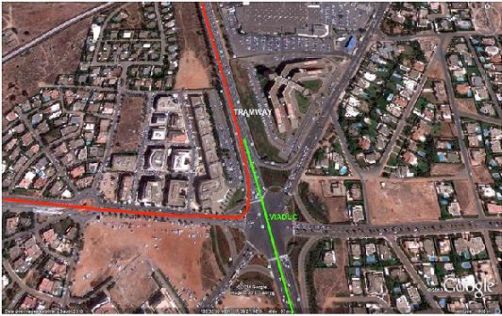
The field study, and the diagnosis of the various factors
of housing development, in addition to the determinants Figure 4. Completion of the Al Mouahidine Street underground corridor
that contribute to directing it in the city of Casablanca,
allowed to define the elements of a field, which mainly
contribute to affecting the pace of expansion of the built 8. Conclusions
area and direct the housing in the study area, perhaps the
most important of which is reflected in the topographical The study on the ground and the diagnosis of various
situation, housing and road axes Figures 3 and 4, then the factors of housing development, in addition to the
non-buildable ranges or domains, like the inspired strip and determinants which contribute to direct it in the city of
waterways. And the preparation of layers according to the Casablanca, made it possible to identify four elements of
available data, allows performing the field analysis. We ground, which mainly contribute to influence the rate of
also refer to the presence of other elements that contribute expansion of the built-up area and directing housing in the
to the dynamism of reconstruction, for example, the diverse study area, the most important of which is reflected in the
status of real estate systems of land in the city of topographic situation, housing and highways, then beaches
Casablanca, such as lands belonging to military properties, or non-building areas, such as the coastal strips and roads
state lands and confinement, as well as private which we navigable
could not categorize or determine its area distribution, and Information systems contribute to the realization of the
generalized the dominance of the study. On the territory of ground analysis as well as a contribution to the dynamics of
the country that is considered the most prevalent, and is construction, for example, the diversified status of real
also the easiest in terms of mobilization, whether by the estate systems for slums and buildings threatened with
population or dirt groups for the purposes of construction collapse, and are the easiest way to mobilize, whether by
and equipment [13-14]. residents or land groups for construction and equipment
Acknowledgements
The authors thank the Casablanca Council and the
Casablanca Urban Agency for all the information.
REFERENCES
[1] Belkhiri, B., Compte, J. P., El Khabouti, A., El Hamouri, A.,
& Meryouh, D. Bilan de cinq années de Sécheresse au
Maroc. Revue eau et développement N3,13–33. 1987.
Figure 3. Preparation of structured roads and Azbane junction370 The Contribution of the Urbanization of the Information System on Urban Development the in Casablanca (Morocco)
[2] Joumady Kacem. Urbanisation et disparités spatiales au Renewal, 44th ISOCARP Congress 2008.
Maroc. In: Méditerranée, Littoralisation et disparités
spatiales Machrek Maghreb. tome 91, pp. 93-100. 1999. [9] B. Zyani, « Habitat, contrainte foncière et développement
urbain à Casablanca », Habitat, état, société au Maghreb,
[3] Belinda Ng, Elizabeth, Eu Mee Chong, Implementation of sous la direction de R. Baduel, C.N.R.S., Paris 1988, p.
Shallow Underpasses at an Urban Roundabout, IJATCSE. 213-229.
pp. 375-382, Volume 8, No.3, May - June 2019
[10] Dorning, M. A., Koch, J., Shoemaker, D. A., &
[4] Daaif, J., Zerraf, S., Tridane, M., Benmokhtar, S., Belaaouad, Meentemeyer, R. K. Simulating urbanization scenarios
S. Computer simulations as a complementary educational reveals tradeoffs between conservation planning strategies.
tool in practical work: Application of monte-carlo Landscape and Urban Planning, 136(3), (2015). 28–39.
simulation to estimate the kinetic parameters for chemical
reactions. IJATCSE. pp. 249-254. Volume 8, No.1.4, 2019 [11] Estoque, R. C., & Murayama, Y. (2015). Intensity and
spatial pattern of urban land changes in the megacities of
[5] Cesar A. Llorente, Jefferson O. Ang, Kenneth Robert O. Southeast Asia. Land Use Policy, 48, (2015), 213–222.
Chan Shio, John Eric O. Chua, Elijah Ivin C. Cu
Implementation of a Web based Weather Monitoring Station [12] Fan, C., &Myint, S. A comparison of spatial autocorrelation
and Data Storage System. IJATCSE. Pp 527-530. Volume 8, indices and landscape metrics in measuring urban landscape
No.3, May - June 2019. fragmentation. Landscape and Urban Planning, 121, (2014).
117–128.
[6] S. Kevin Andrews, V. Jeyabalaraja, M.S. Josephine. Vehicle
Information System using R-Pi and Internet of Things [13] Bae, J., &Ryu, Y. Land-use and land cover changes explain
IJATCSE. pp. 2156 - 2160. Volume 8, No.5, September - spatial and temporal variations of the soil organic carbon
October 2019. stocks in a constructed urban park. Landscape and Urban
Planning, 136, (2015). 57–67.
[7] Eric Vaz, Pedro cabral, Mario caetano, M. Painho. Urban
heritage endangerment at the interface of future cities and [14] Bahi, Hicham & Rhinane, Hassan & Bensalmia, Ahmed &
past heritage: A spatial vulnerability assessment. Habitat Fehrenbach, U. & Scherer, Dieter. Effects of Urbanization
International 36(2):287-294. 2012 and Seasonal Cycle on the Surface Urban Heat Island
Patterns in the Coastal Growing Cities: A Case Study of
[8] Li Rui, Urban Heritage Conservation by GIS under Urban Casablanca, Morocco. Remote Sensing. 8. (2016). 829.You can also read