The German Radar Station La 318 Frosch - Scientific ...
←
→
Page content transcription
If your browser does not render page correctly, please read the page content below
Archaeological Discovery, 2021, 9, 113-134
                                                                                                   https://www.scirp.org/journal/ad
                                                                                                             ISSN Online: 2331-1967
                                                                                                               ISSN Print: 2331-1959

The German Radar Station La 318 Frosch

Giancarlo T. Tomezzoli1, Jean-Luc Moser2
1
    Etno-Archaeological Observatory, Munich, Germany
2
    Archives Municipales, Saint Malo, France

How to cite this paper: Tomezzoli, G. T.,       Abstract
& Moser, J.-L. (2021). The German Radar
Station La 318 Frosch. Archaeological Dis-      It is common opinion that WWII was characterised by small and great air,
covery, 9, 113-134.                             land and sea battles. This is true, but it ignores the role played by installations
https://doi.org/10.4236/ad.2021.92006           of advanced technology for collecting information about the enemy inten-
                                                tions. The German support point La 318 Frosch (Frog) at Cap Fréhel (Plé-
Received: February 25, 2021
Accepted: April 10, 2021
                                                venon) near Saint Malo (Brittany—FR) is one of the best examples. Built
Published: April 13, 2021                       among precedent military and civilian French signal components, it hosted
                                                sophisticated surveillance components. The visits conducted on the site, per-
Copyright © 2021 by author(s) and               mitted to identify La 318 components, to determine their preservation state at
Scientific Research Publishing Inc.
                                                about eighty years from the end of the WWII and to proceed to the compo-
This work is licensed under the Creative
Commons Attribution International               nents reconstruction.
License (CC BY 4.0).
http://creativecommons.org/licenses/by/4.0/     Keywords
                Open Access
                                                WWII, La 318, Frosch, Goldfisch, Radar, Freya, Würzburg Riese, Mammut,
                                                Cap Fréhel, Plévenon, Brittany

                                              1. Introduction
                                              It is common opinion that WWII was characterised by small and great air, land
                                              and sea battles. This is true, but it ignores the role played by installations of ad-
                                              vanced technology for collecting information about the enemy intentions (Jones,
                                              2009). The German support point (Stp—Stützpunkt) La 318 (Lamballe 318)
                                              Frosch (Frog) at Cap Fréhel (Plévenon) near Saint Malo (Brittany—FR) is one of
                                              the best examples. Built among precedent military and civilian French signal
                                              components, it hosted sophisticated surveillance components.

                                              2. History
                                              After precedent lighthouses, on 1702 on Cap Fréhel a headlight began its service
                                              burning at the beginning coal and after whale and rapeseed oil. On 1st May 1847 a
                                              new 1st class lighthouse began its service. Its two white pulses every 10 sec. were

DOI: 10.4236/ad.2021.92006 Apr. 13, 2021                           113                                     Archaeological Discovery
G. T. Tomezzoli, J.-L. Moser

                               visible up to 40 km. It had an octagonal tower 22 m high, 3.40 m in diameter with
                               dependencies for guardian lodgments on the sides. On 1860, the municipality of
                               Plévenon purchased for 60 Francs a 50 ares parcel (half hectare) from the French
                               Navy for constructing an electro-semaphore in connection with that of Saint-Cast-
                               Le-Guildo, on the place of an ancient telegraph. The electro-semaphore, T shaped,
                               with large windows and no floors, was burned on 1940 by French soldiers before
                               the arrival of German troops. From 1940, due to the German military interest, La
                               318 was developed, comprising surveillance and defensive components, under the
                               direction of the Oberbauleitung Saint-Malo. A Decauville rail track was arranged
                               for the transport of construction materials on the site (GLAD, 2020).
                                  The sources are not in agreement about the surveillance radar in service at La
                               318, either: 1 × FuMG 401 LZ Freya, 1 × FuMG 65 L Würzburg Riese at Stp I; 1
                               × Mammut at Stp II; 1 × FuMG 450 Flamme, 1 × FuMG 65 L Würzburg Riese, 1
                               × Würzburg 39(t) at Stp III (Kerhousse, 2016); or: 1 × FuMO 214 Würzburg
                               Riese, 1 × FuMO 2 Calais B; 2 × FuMG 65 L Würzburg Riese, 1 × FuMG 80
                               Freya A/N and later 1 × FuMG 401 LZ Freya, 1 × FuMG 80 Freya with Gemse
                               and A/N, and still later 1 × FuMG 450 Freya, 1 × FuSE 62 D; 1 × FuMG 41 G
                               (cF) Mammut, 1 × FuMO 214 (DAWA, 2016). A radar FuMO 2 was placed on
                               top of the headlight for air and sea surveillance (DAWA, 2016; Powelei, 2012)—
                               Appendix A1. A radio station was located in the lighthouse and five mine fields
                               with stakes against glider planes were established.
                                  In service took turn the 22./LgNaRgt Westfrankreich, 1. and 3. FuMAbt, 24./
                               LgNaRgt 12 and after 5./FlugmeldeLeitKp II./LnRgt 54, 1/3 FuMAbt Brest. In
                               total, La 318 garrison reached 230 officers and soldiers.
                                 On 11th August 1944 the garrison destroyed the lighthouse, and, under the
                               orders of lieutenant Sasse, on 30th August 1944 surrendered unconditionally to
                               the American troops.
                                 On 1945 the headlight restarted its service with a high tension provisional
                               light and an emergency generator. On 1st July 1950 a new lighthouse began its
                               service with a halogen lamp whose two white pulses every 10 sec. were visible up
                               to 200 m in foggy and 110 km in clear weather. On 1952, the Touring-Club-
                               de-France (founded in 1890) rented part of the Roche Jaune for facilitating the
                               reception of tourists and prepared a platform, at the site of an ancient steam
                               foghorn. On the platform, stands up the tower of a modern two sounds per
                               minute foghorn (GLAD, 2020).

                               3. The Visits
                               The visits to La 318 (Figure 1) took place on 18 August 2005, 11 January 2011,
                               08 August 2020 and permitted to identify Stp I, Stp II and Stp III components
                               (Kerhousse, 2016).

                               3.1. Stp I
                               The Stp I identified components (Figures 2-8) were the following.

DOI: 10.4236/ad.2021.92006                         114                                   Archaeological Discovery
G. T. Tomezzoli, J.-L. Moser
A ditch (48˚40'49.64"N, 2˚19'27.94"W, height 57.74 m) (1), 45 x 16 m, about
713 m2, provided with a side access ladder. On its floor, partially invaded by
vegetation, two parallel concrete rails, spaced apart of 3.5 m. On the side
walls, pebbles of the EroVili (Tomezzoli & Marzin, 2015) and formwork
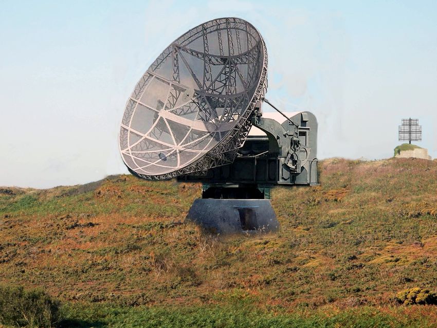
Figure 1. La 318—Stp I; Stp II; Stp III; a Pointe du Jas; b Amas du Cap; c Roche Jaune; d
lighthouse square; e nowadays parking; f Pointe du Château-Renard; g Lalande de Fréhel,
h Cap Fréhel access road. [Geoportail]
element traces were visible. Its concrete structure, disfigured by a recent graffiti
on the north side wall, was in good preservation state without damages due to
combats.
A small bunker (48˚40'48.97"N, 2˚19'27.29"W, h 62.51 m) sunk into the ter-
rain, 12 m south from the L 486. Its coverage was partially invaded by vegeta-
tion. A short access trench led to its entrance, which obstructed by vegetation, let
the interior inaccessible. Its concrete structure was in a good preservation state
without damages due to combats.
A water tank (WBH Wasserbehalter) bunker (48˚40'49.49"N, 2˚19'24.41"W,
h 69.82 m) (2) (Powelei, 2012). Its entrance, invaded by vegetation, introduced
into a 7.5 m long corridor, which preserved on its walls and ceiling the original
white painting disfigured by modern graffiti and formwork element traces. At
90˚ left on the corridor end the entrance to an 6.5 × 3.5 m room. It preserved
on its walls and vaulted ceiling the original white painting disfigured by mod-
ern graffiti and formwork element traces. On its back wall a 1.5 × 0.8 m, 50 cm
DOI: 10.4236/ad.2021.92006 115 Archaeological Discovery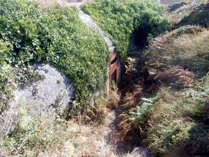
G. T. Tomezzoli, J.-L. Moser

                                       deep niche probably for room ventilation. The corridor and room concrete
                                       structure was in good preservation state without damages due to combats.

                                       Figure 2. La 318—Stp. I: 1 ditch; 2 WBH bunker; 3 stone and brick construction; 4 V 229;
                                       5-7 Flak emplacements; 8 R 622; 9 stone barrack; 10 L 479 Anton bunker. [Geoportail].

                                        A construction (48˚40'49.64"N, 2˚19'23.61"W, h 71.24 m) (3) similar to a
                                       Middle.

                                                     (a)                                                (b)

                                                     (c)                                                (d)

                               Figure 3. (a) ditch (1) access ladder; (b) ditch floor with concrete rails; (c) WBH bunker (2) en-
                               trance invaded by vegetation; (d) WBH bunker internal room.

DOI: 10.4236/ad.2021.92006                                   116                                       Archaeological Discovery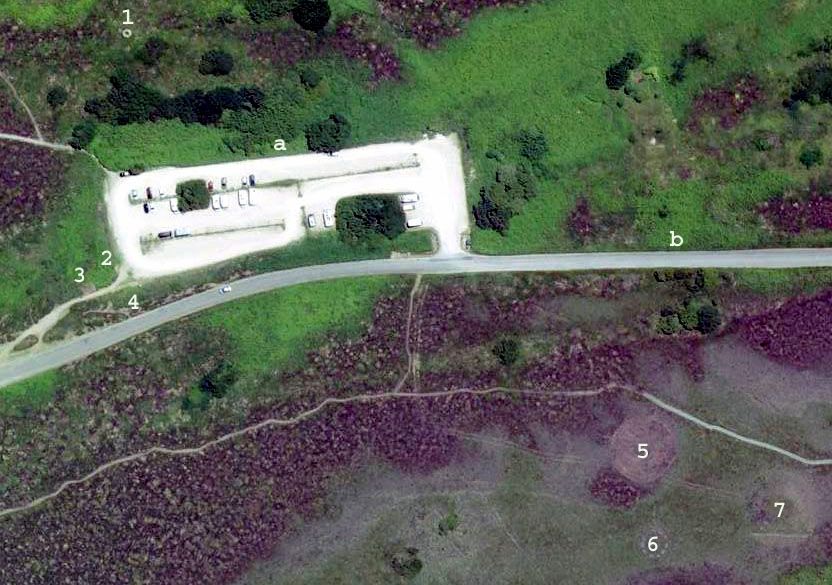
G. T. Tomezzoli, J.-L. Moser

                                                   (a)                                                 (b)

                             Figure 4. Stone and brick construction (3): (a) lower wing; (b) construction interior.

                                       Ages one for Freya radar (Powelei, 2012)—Appendix A5. Around a 5 m high,
                                    5 m in diam. cylindrical tower, a semi-circular wing of the same high toward east
                                    and a lower wing toward west. The Freya antenna was placed on the tower cov-
                                    erage, the instrumentation and personnel lodged at the interior. Its internal and
                                    external stone and brick structure, partially invaded by vegetation, was in good
                                    preservation state without damages due to combats.
                                       A V 229 support (48˚40'51.6"N, 2˚18'32.75"W, h 65.09 m) (4) for radar Würz-
                                    burg Riese—Appendix 5. A short metallic plate on the upper side protected its
                                    access opening on one of its side walls. The internal floor was covered by stones.
                                    On the internal walls two recesses for shelves or equipment were visible. On the
                                    upper side metallic fixation points and traces of the corresponding Würzburg
                                    Riese supporting elements were visible. On the walls, pebbles of the EroVili
                                    mixed with concrete were visible. The concrete structure was in good preserva-
                                    tion state without damages due to combats.
                                       A first RS 58c Tobruck (48˚40'48.81"N, 2˚19'31.4"W, h 63.43 m) with access
                                    trench and a second RS 58c Tobruck (48˚40'52.51"N, 2˚19'31.51"W, h 62.52 m)
                                    with access trench were visible although partially invaded by vegetation.
                                       A 2 × 1.5 m open cistern (48˚40'49.78"N, 2˚19'32.23"W, h 64.17 m) similar to
                                    those observed at Be-2 at Mont Saint Michel de Braspart (Tomezzoli & Dupont,

                                                     (a)                                               (b)

                             Figure 5. V 229 (4): (a) support for Würzburg Riese; (b) interior walls with two recesses for
                             shelves or equipment.

DOI: 10.4236/ad.2021.92006                                  117                                        Archaeological Discovery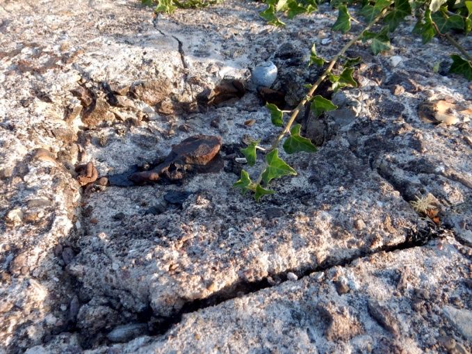
G. T. Tomezzoli, J.-L. Moser

                                                    (a)                                             (b)

                                                    (c)                                             (d)

                               Figure 6. (a) first Flak emplacement (5); (b) second Flak emplacement (6) with Y gun support;
                               (c) third Flak emplacement (7); (d) third Flak emplacement (7) with Y gun support.

                                      2011). Its concrete structure was in a good preservation state without damages
                                      due to combats.
                                         A first, rough in construction, octagonal Flak emplacement (48˚40'52.2"N,
                                      2˚19'33.18"W, h 65.05 m) (5) manufactured by stones bound with concrete,
                                      without underground bunker. Three niches for ammunitions were visible on
                                      three corresponding side walls. On the floor, no Y support for gun holder legs.
                                      Its structure, partially invaded by vegetation, was in a good preservation state
                                      without visible damages due to combats.
                                         A second, rough in construction, octagonal Flak emplacement (48˚40'52.37"N,
                                      2˚19'32.52"W, h 63.98 m) (6) manufactured by stones bound with concrete,
                                      without underground bunker. Two niches for ammunitions were visible on two
                                      corresponding side walls. On the floor, a Y support for gun holder legs. Its struc-
                                      ture, partially invaded by vegetation, was in a good preservation state without
                                      visible damages due to combats.
                                         A third, rough in construction, octagonal Flak emplacement (48˚40'50.66"N,
                                      2˚19'32.99"W, h 65.37 m) (7) manufactured by stones bound with concrete,
                                      without underground bunker. One niche for ammunitions was visible on one
                                      side wall. On the floor, a Y support for gun holder legs, with a circular niche on
                                      each Y arm. Its structure, partially invaded by vegetation, was in a good preser-
                                      vation state without visible damages due to combats.
                                         A R 622 bunker (48˚40’51.15”N, 2˚19’31.04”W, h 64.94 m) (8) for two groups

DOI: 10.4236/ad.2021.92006                                  118                                     Archaeological Discovery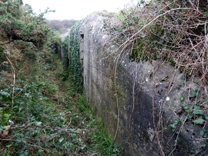
G. T. Tomezzoli, J.-L. Moser

                                                    (a)                                              (b)

                                                    (c)                                              (d)

                             Figure 7. (a) R 622 (8) entrance of the observation post; (b) R 622 observation post aperture; (c)
                             R 622 entrance; (d) stone barrack or water reservoir (9).

                                    each of ten soldiers (Rudi, 1988), partially covered by vegetation. On the coverage,
                                    the circular aperture of the observation post with a circular metal ring and three
                                    circular concrete emplacements each with a 10 cm in diam. circular aperture.
                                    Two entrances were obstructed by vegetation and recent barriers, so that the in-
                                    terior remained inaccessible. However, one of said entrances let visible a de-
                                    scending ladder with original white and orange wall paintings and rusted ceiling
                                    metal portions. The concrete structure was in good preservation state without
                                    visible damages due to combats.
                                       A 3 × 5 m stone barrack or water reservoir (48˚40'51.25"N, 2˚19'30.26"W, h
                                    62.08 m) (9). The floor was invaded by stones and vegetation and its access
                                    trench was still visible on the terrain. The stone structure was severely degraded.
                                       An L 479 Anton bunker (48˚40'47.07"N, 2˚19'22.73"W, h 69.78 m) (10) for
                                    night-fighter control (Fleuridas et al., 2010)—Appendix A2-A3, similar respec-
                                    tively to that of the radar camp at Saint-Pabu-Le Bous (Tomezzoli & Colliou,
                                    2017a; Tomezzoli & Colliou, 2018) and at Saint-Jacques de la Lande near Rennes
                                    (Dupont et al., 2007). Pebbles of the EroVili and traces of formwork elements
                                    were visible on the façade. The entrances were obstructed by recent barriers and
                                    vegetation, so that the interior remained inaccessible. However, the re-cooling
                                    room conduit let visible the original white wall painting. Its concrete structure,
                                    disfigured by recent graffiti, was in good preservation state without damages due

DOI: 10.4236/ad.2021.92006                                 119                                       Archaeological Discovery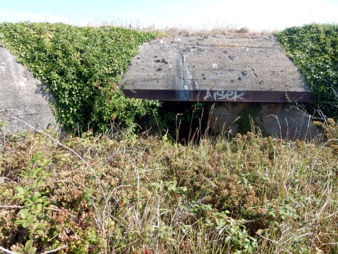
G. T. Tomezzoli, J.-L. Moser

                                                     (a)                                               (b)

                                         (c)                                 (d)                                   (e)

                               Figure 8. L 479 bunker (10): (a) observation post entrance; (b) facade; (c) observation post inte-
                               rior; (d) façade detail; (e) re-cooling room conduit with original white painting.

                                       to combats.

                                       3.2. Stp II
                                       The Stp II identified components (Figures 9-12) were the following.
                                         An L 485 bunker for radar FuMG 41 G (cF) Mammut Caesar (48˚40'33.34"N,
                                       2˚19'14.6"W, h 74.38 m) (1) (DAWA, 2016) invaded by vegetation—Appendix
                                       A4. The façade let visible pebbles of the EroVili and formwork element traces.
                                       Although disfigured by modern graffiti, it was in good preservation state without
                                       damages due to combats. Two rectangular pylons protruding from the coverage
                                       and invaded by orange lichens at the top were in good preservation state. A cy-
                                       lindrical tube emerged from the top of the west one. An entrance gave access to
                                       an observation post surprisingly clean, without internal walls painting. Another
                                       entrance, preserving its original white painting and defense loophole at the lad-
                                       der end, allowed access to the interior. The internal rooms were surprisingly
                                       clean and in good preservation state without damages due to combats. The walls
                                       preserved their original white and orange paintings here and there disfigured by
                                       modern graffities and formwork element traces. On the floors the original tiling
                                       was still in place and the ceilings appeared severely rusted. The compensator
                                       room preserved on one wall the main entrance for instrumentation and

DOI: 10.4236/ad.2021.92006                                   120                                       Archaeological Discovery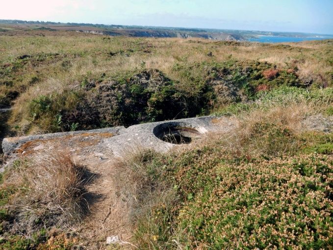
G. T. Tomezzoli, J.-L. Moser

                             Figure 9. La 318—Stp II: 1 bunker L 485 for radar FuMG 41G (cF) Mammut Caesar; 2 barrack; 3
                             possible RS 58c Tobruck, 4 water reservoir/pool; 5 Flak emplacement; 6 Flak emplacement. [Geo-
                             portail].

                                              (a)                                                (b)

                                              (c)                                                (d)

                      Figure 10. L 485 (1): (a) protruding rectangular pylons; (b) observation post entrance; (c) façade with
                      modern graffities; (d) entrance with defense loophole.

DOI: 10.4236/ad.2021.92006                                 121                                         Archaeological Discovery
G. T. Tomezzoli, J.-L. Moser

                                                     (a)                                               (b)

                               Figure 11. L 485: (a) internal room, on the right wall defence loophole on the left wall metallic
                               support of unknown purpose; (b) compensator room.

                                      materials obstructed by terrain and on each adjacent side wall the access to the
                                      antenna room. Each access had 12 circular cable passages on each side. On the
                                      floor a 3 × 2 m rectangular support for the compensator, with two square sup-
                                      ports on each longer side. Another 1 × 0.5 m rectangular support with a fixation
                                      point at each angle was aligned with the shorter side. The antenna room ceiling
                                      had twenty four cable accesses toward the corresponding external protruding
                                      pylon. All the technical instrumentations and furniture disappeared.
                                         A 15 × 13 m barrack (48˚40'34.22"N, 2˚19'12.07"W, h 67.08 m) (2). The roof
                                      disappeared and because of vegetation coverage, the interior remained inaccessi-
                                      ble. The stone structure was severely degraded.
                                         A possible RS 58c Tobruck (48˚40’32.91"N, 2˚19’11.32"W, h 66.77 m) partially
                                      invaded by vegetation.
                                         A 6 × 10 m barracks (48˚40'32.7"N, 2˚19'11.36"W, h 69.06 m) near the RS 58c.
                                      Because of vegetation coverage, the interior remained inaccessible. The stone
                                      structure was severely degraded.

                                                     (a)                                               (b)

                               Figure 12. L 485: (a) gas lock and antenna room; (b) antenna room ceiling.

                                        A 7 × 10 m, 1.5 m deep water reservoir/pool (48˚40'35.19"N, 2˚19'16.35"W, h
                                      71.31 m) (4). Completely invaded by vegetation, it remained inaccessible.
                                        A first 2.5 × 2.0 m Flak emplacement (48˚40'35.52"N, 2˚19'16.84"W, h 73.04

DOI: 10.4236/ad.2021.92006                                   122                                       Archaeological Discovery
G. T. Tomezzoli, J.-L. Moser
m) (5) with a 3 m long access passage. Completely invaded by vegetation, it re-
mained inaccessible.
A second 2.5 × 2.0 m Flak emplacement (48˚40'33.51"N, 2˚19'15.54"W, h
74.35 m) (6) without access passage. Completely invaded by vegetation, it re-
mained inaccessible.
A third 2.5 × 2.0 m Flak emplacement (Powelei, 2012). Completely invaded by
vegetation its position identification was not possible.
3.3. Stp III
The Stp III identified components (Figures 13-18) were the following.
A V229 support (48˚40'55.95"N, 2˚18'0.3"W, h 66.4 m) (1) for radar Würz-
burg Riese. The interior invaded by vegetation was not accessible. On the upper
side the metallic fixation points and the traces of the corresponding Würzburg
Riese supporting elements were visible. On the walls, pebbles of the Ero Vili
mixed with concrete were visible. The concrete structure was in good preserva-
tion state without damages due to combats.
A 4 × 6 m SEA power generator aggregate (Stromerzeuger aggregat) bunker
(48˚40'55.95"N, 2˚19'0.3"W, h. 67.04 m) (2) (Lippmann, 2018) invaded by vege-
tation, the entrance closed by a wood barrier remained inaccessible. The cover-
age was 1 m thick and on the entrance side 7 vertical camouflages slits were visi-
ble. The concrete structure was in good preservation state without damages due
to combats.
A 4 × 5 m bunker (48˚40’56.44”N, 2˚19’5.21”W, h. 68.9 m) (3) buried in the
terrain. The concrete coverage was in good preservation state without damages
Figure 13. La 318 Stp III—1 V229; 2 small bunker; 3 buried bunker; 4 rectangular structure; 5-7
circular areas; a nowadays parking; b Cap Fréhel lighthouse access road [Geoportail].
DOI: 10.4236/ad.2021.92006 123 Archaeological DiscoveryG. T. Tomezzoli, J.-L. Moser
(a) (b)
Figure 14. VF 229: (a) support for Würzburg Riese; (b) imprint of the radar connection.
due to combats.
A 17 × 6 m structure (48˚40'56.27"N, 2˚19'5.82"W, h. 70.29 m) (4), S/W-N/E
oriented, of rectangular shape with rounded short sides, invaded by vegetation.
The N/E side hosted the entrance, the interior four aligned circular gun emplace-
ments, the S/W side disappeared under the Cap Fréhel lighthouses access road (b).
A FuMo 2 Seetakt emplacement near the lighthouse of 1950 remained uniden-
tified.
A first 30 m in diam. circular area (48˚40'49.37"N, 2˚19'8.28"W, h. 69.39 m)
(5), a second 10 m in diam. circular area, (48˚40'47.55"N, 2˚19'9.46"W, h. 63.56
m) (6) and a third 35 m in diam. (48˚40'49.18"N, 2˚19'10.17"W, h. 63.34 m) (7)
located about 200 meters S/W of the nowadays parking (48˚40'54.05"N, 2˚19'
3.3"W, h. 66.67 m) (a). They were evident because of different colour and height
of their moorland grass with respect to that of the surroundings.
Two storage bunkers, two cisterns, a stone personnel bunker with concrete
coverage, a bunker with Flak open emplacement (OBFla), a VF 229, a VF ma-
chine bunker (Trafostation), two tobruck, an ammunition bunker, a Freya FuSE
80 emplacement, two Flak emplacements (Powelei, 2012) about 130 m south of
the a nowadays parking (a), invaded by vegetation, remained inaccessible.
The French Batterie Est (48˚41'13.87"N, 2˚19'1.36"W, h. 61.09 m) and Batterie
(a) (b)
Figure 15. (a) small bunker (2); (b) lighthouses square, on the left the headlight, on the right the
1950 lighthouse with dependencies.
DOI: 10.4236/ad.2021.92006 124 Archaeological DiscoveryG. T. Tomezzoli, J.-L. Moser
(a) (b)
(c) (d)
Figure 16. (a) 30 m in diam. circular surface; (b) 10 m in diam. circular surface; (c) 32 m in diam.
circular surface; (d) a room of the French ammunition depot.
Ouest (48˚41'13.79"N, 2˚19'3.37"W, h. 58.33 m), on Roche Jaune, each compris-
ing a platform with two in barbette parallel 95 mm Lahitolle 1888 or 1914/18
gun emplacements each formed by a concrete arc connected by three concrete
segments to a central, circular six bolts metallic support, observed during the 11
January 2011 visit, disappeared.
A nearby circular concrete gun emplacement (48˚41'15.2"N, 2˚19'3.12"W, h.
58.87 m) with 14 circularly disposed fixation bolts for 9.5 cm French Canon de
Côte 95 M93, identified during the 11 January 2011 visit, disappeared.
(a) (b)
Figure 17. Roche Jaune: (a) semaphore emplacement, on the background the foghorn tower, (b)
semaphore emplacement circular surface, on the background lighthouse and headlight.
DOI: 10.4236/ad.2021.92006 125 Archaeological DiscoveryG. T. Tomezzoli, J.-L. Moser
(a) (b)
(c) (d)
Figure 18. Roche Jaune: (a) belvedere; (b) foghorn platform, on one side the nowadays foghorn
tower, on the other side emplacement of the old foghorn house, (c) old foghorn house, rests of the
perimeter walls and diagonal covered trench; (d) old foghorn house, structures on the floor.
The 6 × 8 m semaphore emplacement (48˚41'13.5"N, 2˚19'2.01"W, h. 62.19
m). The two houses forming its T shape disappeared. The perimeter walls dis-
appeared and on the concrete floor a 2.5 m in diam. circular surface was visible.
A belvedere (48˚41'7.91"N, 2˚18'59.34"W, h. 57.23 m) with stone walls formed
by a 6 × 21 m rectangular platform and a 2 m higher 14 m in diam. semi-circular
platform. It resulted from the 2012 demolition of the restaurant La Fauconnière
built on the 1920s and present at La 318 during the WWII.
Three rings on the terrain for anchoring a disappeared French semaphore
mast, observed during the 18 August 2005 visit, disappeared.
The 13 × 13 m foghorn platform (48˚41'16.09"N, 2˚19'3.21"W, h. 56.83 m). On
one side the tower of the nowadays foghorn in good preservation state, on the
other side the 7 × 10 m concrete emplacement of the old foghorn house. Rests of
house perimeter walls were visible. On the concrete floor a diagonal, concrete
covered trench for electrical cables, connected to three in triangular disposition 1
m in diam. concrete, circular emplacements. They formed the bases of the foghorn
vapour generators. In front of the circular emplacements the semi-circular cover-
age rests of the of the water cisterna.
4. Discussion
The majority of the literature sources identify the La 318 (Rapport Pinczon du
DOI: 10.4236/ad.2021.92006 126 Archaeological DiscoveryG. T. Tomezzoli, J.-L. Moser
Sel, 1947-1948) cover name as Frosch, except two (Glad, 2020; Lippmann, 2018)
which identify the cover name as Goldfish. However, the radar station Goldfish
was at Guernsey, one of the Channel Islands (DAWA, 2016). Therefore, the
identification of these two sources is incorrect.
Substantially, La 318 repeats the architecture of Stp Re 510 (Renan 510) Pin-
guin at Saint-Pabu-Le Bous (Tomezzoli & Colliou, 2017a) near Brest, of Funk-
meßstellung 2. Ordnung Mandrill at Monterfil (Dupont et al., 2007; Tomezzoli
& Pottier, 2015) near Rennes and Funkmeßstellung 1. Ordnung Made at Les
Mées (Dupont et al., 2007) near Le Mans essentially based on two Freya and two
FUSE 65 Würzburg Riese. Two Freya and two Würzburg Riese were necessary
for assuring continue surveillance also in case of maintenance or malfunctioning
of one of them.
Mammut Caesar was an early warning radar able to detect aircrafts up to 300
km in two directions perpendicular to its rectangular antenna, but blind in a
range of 60˚ on the antenna sides. Freya was an early warning radar detecting
aircrafts up to 200 km but unable to determine their altitude. Würzburg Riese,
often coupled to an IFF (Identification Friend Foe) device, was a near field
warning radar detecting aircrafts up to 70 km, their azimuth and their altitude.
Therefore, incoming aircrafts were first intercepted by the Mammut and Freya
and after by the Würzburg Riese which, in case of foe aircrafts, provided data for
directing the fire of the Flak emplacements. During day and night aircraft inter-
ceptions, the personnel of L 479 Anton collected all the available radar informa-
tion and drove at least two interceptors against the target aircraft/s. The second
interceptor was directed on the target aircraft/s in case of failure of the first one
(Trenkle, 1979).
The personnel in service at La 318 lodged mainly in the lighthouse dependen-
cies and in wood barracks on the right side of the lighthouses access road (b) (h).
However, no barrack rests were identified.
4.1. Stp I
The presence of the L 479 Anton indicates that the Stp I components pertained
to the Luftwaffe, as in the case of Saint-Pabu-Le Bous (Tomezzoli & Colliou,
2017a).
The ditch reminds the barrack emplacements (6)-(10) observed at the Stp
Menez-Hom (Tomezzoli, 2017b). It protected either a large barrack or barracks
(Lippmann, 2018; Powelei, 2012) or electrical generators (GLAD, 2020). The
sources would not be in contradiction if the electrical generators were lodged in
the large barrack or barracks, today disappeared, laid on the observed concrete
rails. However, it is also possible that said large barrack or barracks lodged per-
sonnel. The ditch was covered with camouflage nets.
A 22 x 16 m rectangular excavation (48˚40'48.26"N, 2˚19'24.16"W, h. 64.51 m)
between L 486 and L 489, identified in a French air reconnaissance image
(C3639-0531_1948_MISSIONBRETAGNE16AV, n˚146, 1/26228, Argentique,
14/05/1948) escaped identification because the vegetation coverage.
DOI: 10.4236/ad.2021.92006 127 Archaeological DiscoveryG. T. Tomezzoli, J.-L. Moser
A R 656 for fifteen soldiers has been signalled (Lippmann, 2021), but its pres-
ence has not been identified.
Candidates for the Flak emplacements were either a 2 cm single Flak 30, or a 2
cm Flakvierling 38 or a 3.7 cm Flak 18/36/37 gun.
4.2. Stp II
The presence of the FuMG 41 G (cF) Mammut Caesar indicates that the Stp II
components pertained to the Luftwaffe.
Because no personnel lodgement was foreseen inside the L 485 the personnel
lodged in the two nearby barracks. It is possible that either the smaller one
hosted a kitchen/canteen and the bigger one personnel lodgements. The disap-
peared technical instrumentations and furniture were probably confiscated by
the American or French army.
The absence of the radar antenna in said 1948 French air reconnaissance im-
age indicates that it was dismantled before 14/05/1948. Actually, antenna por-
tions were used for the construction of cereals silos in a nearby farm.
The water reservoir/pool, already observed at the Murs-Erigné German base
(Tomezzoli, 2016) and the Domaine de Pignerolle (Tomezzoli et al., 2013) pro-
vided relax to the personnel and water in case of fire in the Stp II components.
Candidates for the Flak emplacements were either a 2 cm single Flak 30, or a 2
cm Flakvierling 38 or a 3.7 cm Flak 18/36/37 gun.
4.3. Stp III
The Stp III components pertained to the Kriegsmarine, as in the case of Saint-
Pabu-Le Bous (Tomezzoli & Colliou, 2017a).
The rectangular structure (4) was a four guns in barbette French battery, pre-
ceding La 318. Because of its open structure, the guns might defend the whole
Cap Fréhel.
The three circular surfaces (5)-(7) were probably whip antenna emplacements.
This is suggested by the radio station was located in the lighthouse (GLAD,
2020) and a corresponding reinforced field-like Vf (Verstärkt feldmässige) tele-
communication (Fernmelde stand) bunker (Lippmann, 2018) which unfortunately
was not identified and no concrete antenna cable fixing block was identified.
An east and west parallel 20 x 6 m barrack on the of the Cap Fréhel lighthouse
square, visible in said French air reconnaissance image, hosting respectively the
kitchen/canteen and officers lodgements (Glad, 2020) disappeared before 21/
05/1952 (C3639-0531_1948_MISSIONBRETAGNE16AV, n˚146, 1/26228, Argen-
tique, 14/05/1948; C1215-0101_1952_F0915-1215_0002, n˚2, 1/25842, Argentique,
21/05/1952).
The French Batterie Est and Batterie Ouest constituted a defence against ships
and submarines. Especially these last, because of their limited autonomy and the
danger of navigating in immersion near the coast often emerged and engaged
the coastal defences by their gun.
DOI: 10.4236/ad.2021.92006 128 Archaeological DiscoveryG. T. Tomezzoli, J.-L. Moser
5. Conclusion
This article permitted us to put order in a lot of information concerning La 318
and other precedent and coexisting French military and civilian structures on
Cap Fréhel and to present the information in an organic way accessible to a pub-
lic of experts and amateurs. We hope that this article will stimulate further stud-
ies on other WWII installations of advanced technology, because they influence
on military operations, life and fate of thousands of men.
Acknowledgement
The authors are grateful to Mr Fleuridas P. for his explanations and his kind
permission to insert in the Appendix the plants of the bunkers L 479 Anton and
L 485.
Conflicts of Interest
The authors declare no conflicts of interest regarding the publication of this pa-
per.
References
DAWA (Deutsches Atlantikwall-Archiv) (2016). Deutsches Atlantikwall Archiv. Stand:
17. Dezember 2016. http://www.atlantikwall.info
Dupont, Ph., Fresil, Y., & Tomezzoli, G. (2007). Deutsche Militärbauten bei Rennes.
DAWA Nachrichten, 49, 56-66.
Fleuridas, P., Herbots, K., & Peeters, D. (2010). Constructions Normalisées de l’Armée de
l’Air: Regelbauten der Luftwaffe. France: Ed. des Auteurs.
GLAD (2020). L’Inventaire du Patrimoine Culturel de Bretagne.
http://patrimoine.bzh
Jones, R. V. (2009). Most Secret War. British Scientific Intelligence 1939-1945. London:
Penguin Books.
Kerhousse, Y. (2016). Côtes du Nord 1940-1944. Les installations radar allemandes. De la
pointe du Cap Fréhel et leur environnement historique. Plérin: Association GERFRAUT.
Lippmann, H. (2018). La 318 Goldfisch—Map F3 2118 010B [F3 203].
Lippmann, H. (2021). Private Communication.
Powelei, J. (2012). LA 318 Frosch. Cap Fréhel. Map 08/2012.
Rapport Pinczon du Sel (1947-1948). Le Mur de l’Atlantique la Cote de la Manche et de
l’Atlantique du Mont Saint-Michel à Laita. Service Historique de la Marine. Brest, Livre
IV. Plan No. 23 IV.
Rudi, R. (1988). Typologie du Mur de l’Atlantique. NUGI 923. Amsterdam: Beetsterzwaag.
Tomezzoli, G. T. (2016). The German Base “The Bank” at Mûrs-Érigné (Anjou-FR). Ar-
chaeological Discovery, 4, 37-47. https://doi.org/10.4236/ad.2016.41004
Tomezzoli, G. T. (2017b). The WW II German Stützpunkt on the Menez-Hom (Finistère-
FR). Archaeological Discovery, 5, 224-237.
https://doi.org/10.4236/ad.2017.54013
Tomezzoli, G. T., & Colliou, S. (2017a). The WW II Saint-Pabu German Radar Camp and
the Stützpunkte Re 03, Re 04. Archaeological Discovery, 5, 142-162.
DOI: 10.4236/ad.2021.92006 129 Archaeological DiscoveryG. T. Tomezzoli, J.-L. Moser
https://doi.org/10.4236/ad.2017.53009
Tomezzoli, G. T., & Colliou, S. (2018). The WW II Saint-Pabu German Radar Camp-2.
Archaeological Discovery, 6, 88-102. https://doi.org/10.4236/ad.2018.62006
Tomezzoli, G., & Dupont, Ph. (2011). Die Drehfunkfeueranlage Bernhard auf dem Mont
Saint Michel de Brasparts. DAWA Nachrichten, 57, 4-15.
Tomezzoli, G., & Marzin, Y. (2015). The Ero Vili and the Atlantic Wall. Advances in An-
thropology, 5, 183-204. https://doi.org/10.4236/aa.2015.54018
Tomezzoli, G., & Pottier, L. (2015). Die deutschen militärlogistischen Anlagen westlich
von Mamers. DAWA Nachrichten, 65,14-27.
Tomezzoli, G., Pottier, L., Marquet, C., & Letertre, M.(2013). Les Installations de la Kri-
egsmarine au Domaine de Pignerolle. 39-45 Magazine, 60-72.
Trenkle, F. (1979). Die deutschen Funk-Navigations-und Funk-Fürungsverfahren bis 1945.
Stuttgart: Motorbuch Verlag.
Appendix
A1: reconstruction—FuMO 2 on top of the headlight for air and sea surveillance.
DOI: 10.4236/ad.2021.92006 130 Archaeological DiscoveryG. T. Tomezzoli, J.-L. Moser
A2: L 479 Anton bunker for night-fighter control plan—1 gas lock, 2 close combat room, 3 crew room, 6 ob-
servation post, 20 wireless room, 22 ventilation room, 29 store room, 51 telephone exchange room, 55 store,
79 emergency generator room, 83 transformer room, 84 re-cooling room, 86 command post, 99 fuzes room
(Courtesy Fleuridas P.) (Room numbering according to Rudi, 1988).
DOI: 10.4236/ad.2021.92006 131 Archaeological DiscoveryG. T. Tomezzoli, J.-L. Moser
A3: L 479 Anton bunker for night-fighter control plan (Courtesy Fleuridas P.).
DOI: 10.4236/ad.2021.92006 132 Archaeological DiscoveryG. T. Tomezzoli, J.-L. Moser
A4: bunker L 485 and radar FuMG 41G (cF) Mammut Caesar: 1 gas lock, 2 close combat room, 3 crew
room, 6 observation post, 16 antenna room, 22 ventilation room, 79 emergency generator room, 80
workshop, 83 transformer room, 84 re-cooling room, 100 compensator room (Courtesy Fleuridas P.)
(Room numbering according to Rudi, 1988).
DOI: 10.4236/ad.2021.92006 133 Archaeological DiscoveryG. T. Tomezzoli, J.-L. Moser
A5: reconstruction—FUSE 65L Würzburg Riese on V229, in the foreground FuMG401 Freya LZ (radar im-
age from a non-copyright site).
DOI: 10.4236/ad.2021.92006 134 Archaeological DiscoveryYou can also read