The Nile Water Crisis - The Organization for World Peace - Policy Analysis - The Organization for World ...
←
→
Page content transcription
If your browser does not render page correctly, please read the page content below
The Nile Water Crisis
        Policy Analysis

The Organization for World
          Peace
The Organization for World Peace
Analysis of the Nile Water Crisis
World Peace IS Possible

This document was produced by the OWP’s Policy Analysis
Team: Arthur Jamo, Ingrid Valladares, Jared Hatten and
Olayiwola Ademola.

Jonathon Arrell
Vice President
The Organization for World Peace
Email: vp@theowp.org

Registered Office:
The Organization for World Peace
1 De Boers Drive, Toronto, Canada
Email: worldpeace@theowp.org
Tel: +1(416)58710

                                                      1
Table of Contents
1. Our Aim and Why This Report is Necessary pg. 3
2. Summary pg. 4
3. Importance of the Nile River pg. 5
4. The GERD Crisis pg. 7
5. The Nile Basin countries: Egypt, Ethiopia and Sudan pg. 10
6. Nile Basin Issues pg. 12
▪ Current Internal Political Issues pg. 12
▪ Environmental issues pg. 12
▪ Water management pg. 15
6. Initiatives and Agreements pg. 19
I. HYDROMET pg. 19
II. TECCONILE pg. 20
III. Nile Basin Initiative pg. 22
IV. UNDUGU pg. 22
V. CFA/Entebbe Agreement pg. 23
VI. Nile Agreement on the Principles for the GERD pg. 24
7. Our Recommendations and Solutions pg. 26
8. Appendices pg. 33
A. Nile River Basin timeline of events pg. 33
B. Map pg. 35
2Our Aim
The aim of this report is two-fold: Firstly, the reports seeks to provide a long-lasting
solution to the current crisis over the construction of Ethiopia's Grand Ethiopian
Renaissance Dam project (GERD). The dam which is expected to be completed in
2020, has led to significant tensions between upstream Ethiopia, Sudan (which has
realigned itself by siding with Ethiopia) and downstream Egypt whose freshwater
supply is under increasing threat as the GERD project nears its completion. Secondly,
the reports aims to provide a series of strategies and policy approaches to reduce the
likelihood of similar water-related conflicts in the Nile River Basin, both in the short-
and long-term. Specifically, this report aims to put forward suggestions to reduce the
environmental, political and climate-related issues that are currently placing pressure on
the Nile River’s water.
Why This Report is Necessary
Historically-speaking, disagreements over transboundary water resources have been a
source of friction as well as a catalyst for peace among nations. Notable examples of
the latter—whereby adversaries turn into partners for peace—include the signing of the
Indus River Treaty between India and Pakistan, which has survived three wars, and the
Senegal River Treaty. In both of these examples, the competing nations found a way to
equitably and reasonably share international waters—and avoid engaging militarily
against one another over the water source.
This report delves into a crisis that has been present for many years and is centered,
much like the abovementioned situations, around the equitable use of a shared
transboundary water resource, the fabled Nile River. While much focus tends to be
placed on the Grand Ethiopian Renaissance Dam project itself, there is a need to shed
light on the existing issues that have exacerbated the present situation between
downstream Egypt and its fellow riparian neighbors. In doing so, this report plays the
important role of providing a more global view of the crisis which has the potential to
destabilize a historically troubled region of the world (as demonstrated by the current
instability in Libya, the post-secession situation in South Sudan, and the insurgency in
Egypt’s Sinai region). Equally as important, is the fact that such reporting will place
greater attention on the wider-issue of how freshwater as a resource can be a source of
potential conflict or peace among the various nations of the world.
3Summary
The Nile River is fed by the White Nile (which begins in the southern part of the Equator) and
the Blue Nile which originates in the Ethiopian highlands. Tanzania, Burundi, Rwanda, the
Democratic Republic of the Congo, Kenya, Uganda, South Sudan, Ethiopia, Sudan, and Egypt
all rely on the Nile for survival and economic development.
In the case of a few of these states, such as Egypt, the Nile is the sole source of water. This
becomes problematic when the availability of this resource comes under continued stress due to
disputes over water allocation, climate change and issues emanating from poor water
management. The current water crisis between Egypt, Ethiopia and Sudan highlights this fact.
Ever since Ethiopia launched the Grand Ethiopian Renaissance Dam project in 2012, there has
been heightened fears of a potential conflict between itself, Egypt and Sudan. This is largely due
to the potential political, economic and hydrological impact (both real or perceived) that it could
have on the mid to long-term future of the countries in question: Ethiopia sees the hydroelectric
dam as a defining national development project that could boost its political and economic
standing in the region; Sudan covets the cheap electricity and expanded agricultural production
that it promises; and Egypt perceives the possible loss of water as an existential threat since it
relies on the Nile for about 90% of its freshwater needs. The Egyptian government argues that
tampering with the river’s flow would put millions of farmers out of work and threaten the
country’s food supply.
Between 2011 and 2017, Egyptian and Ethiopian leaders framed the GERD dispute in stark,
hyper-nationalist terms and exchanged belligerent threats. Politicians in Cairo called for
sabotaging the dam. Media outlets in both countries compared the two sides’ military strength in
anticipation of hostilities. A recent rapprochement has quieted the row. Ethiopia’s new prime
minister, Abiy Ahmed, visited Cairo in 2018 and promised to ensure that Ethiopia’s development
projects do not harm Egypt. In turn, Egyptian President Abdel Fattah al-Sisi said his country
recognizes that the dispute has no military solution. But despite the warming relations, there has
been little substantive progress toward a resolution.
Once it is completed and fully operational, the dam is expected to produce 6,000 megawatts of
power, equal to six nuclear-powered plants. However, it will also divert much of the water that
has historically flowed into the Nile Delta along other routes. With the project 60 percent
complete, Ethiopia can begin collecting water and filling up portions of the dam in a process that
could take up to 15 years. As a consequence, Egypt’s supply of fresh water from the Nile will
drop by an estimated 25 percent over the next seven years. Finding a clear path towards allaying
Egypt’s fears whilst addressing the issues such as the equitable use of water along the Nile has
never been more urgent.
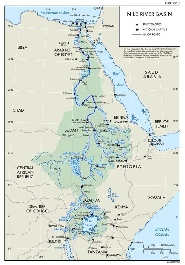
4The Importance of the Nile River
The Nile River, the world's longest river, is of unparalleled social, historic and economic
importance to the more than 300 million people who inhabit the region and rely on its waters for
economic activities and basic human needs. It contains over 10 percent of Africa’s landmass and
covers an area that includes: Ethiopia, Sudan, South Sudan, Egypt (one of the oldest civilizations
in the world), Rwanda, Tanzania, Uganda, Burundi, the Democratic Republic of Congo, Eritrea
and Kenya.
However, the basin has a low supply compared to basins of comparable size. This relative
scarcity of the water resources given the competing demands for productivity and livelihoods
poses a threat to peace and stability as well as food and water security in the basin. The threshold
sufficiency of its water and lack of alternative water sources are of vital importance for the
riparian states. Due to heavy human extraction and high evaporation, the Nile river basin and its
inhabitants are especially sensitive to climate change. The Nile basin traverses the largest
number of countries of any basin in Africa; changes in the timing and availability of water under
climate change may lead to tension, insecurity and management problems.
Food security is the most important issue in today’s Nile River negotiations. Over 80 percent of
water withdrawn from the basin is for irrigation. As populations grow enormously (Ethiopia,
Congo and Egypt are expected to reach 100 million by 2025, with Uganda leading the smaller
countries with 60 million in the same period), fear of demand for food for this growing
population has cast a pall on the negotiations about water allocation for Nile riparian states.
Climate change is now becoming a key driver in considerations over food and energy security in
the Nile. The appalling consequences of inadequate rains over Eastern Africa during the 2004–
2006 period that reduced by half industrial outputs for Uganda, Rwanda and Burundi, with large-
scale famines in Kenya, Ethiopia and Eritrea, have created an opportunity for joint investment
projects, particularly on hydropower, as a counterbalance to securing water for food.
The Nile also happens to be one of more than 260 so-called “international drainage basins”
throughout the world where water, and related, resources are shared between two or more nation
states. At the time of writing this, water demand across the region is steadily rising. When
coupled with rising populations and ambitious initiatives, arguments in favor of a cooperative
sustainable management of the trans-boundary water, and related, resources of the Basin have
become more compelling. The Nile is one of more than 260 so-called “international drainage
basins” throughout the world where water, and related, resources are shared between two or
more nation states.
5The table below breaks down the total area of each riparian state, how much of it falls within the Nile and
how much water is withdrawn from it:
Country Total area (km2) Area within the basin (km2) Water withdrawal per million cubic meters
(a) (b) (c)
Burundi 27 834 13 260 28.7
DRC Congo 2 344 860 22 143 0.0
Egypt 1 001 450 326 751 66054.0
Eritrea 121 890 24 921 unavailable
Ethiopia 1 100 010 365 117 1500.9
Kenya 580 370 46 229 307.5
Rwanda 26 340 19 876 57.4
Sudan 2 505 810 1 978 506 13921.6
Tanzania 945 090 84 200 63.4
Uganda 235 880 231 366 260.3
a and b Source: FAO 1997, World Bank Statistics 2010 tandfonline.com/doi/full/10.1080/0262667.2011.577037
c. Source: Nile Resources Atlas, Chapter 7
The amount of water available to the riparian states of the Nile River water system:
Country Per capita water availability (m3/p/yr)a Projected water availability in 2037
(m3/p/yr)b
Burundi 2,190 1,233
Egypt 790 534
Eritrea 1,470 916
Ethiopia 1,680 974
Kenya 930 577
Rwanda 610 361
South Sudan 1,880 1,129
Sudan 1,880 1,279
Tanzania 2,420 1,413
DRC Congo 23,580 14,337
Uganda 2,470 1,335
a
Source: UNESCO, The United Nations World Water Report 2
b
Estimate based on a population projection
6The GERD Crisis and the Historical Background
The Nile River flows through Rwanda, Burundi, the Democratic Republic of Congo, Tanzania,
Kenya, Uganda, Eritrea, Ethiopia, Sudan, South Sudan and Egypt, before reaching the
Mediterranean Sea. For centuries, the river has been a major source of water supply to three
countries in particular: Egypt, Sudan and Ethiopia. People in these countries have become
dependent on the Nile water for economic activities that rely greatly on agriculture, irrigation
and fishing. And due to its location and its significance, the Nile River has also been a source of
political tensions, which are escalating amid concerns over water flow to Egypt—concerns
which have been the subject of discussion (as will be demonstrated throughout this report).
Several agreements and treaties governing the use of the Nile River’s waters were developed to
manage this resource efficiently, without affecting water flow in any of the riparian countries.
Time, however, has shown that water usage has been highly disproportionate, with Egypt often
being seen as having benefited from two agreements that were signed while it was under a
colonial British administration. The first of these agreements was signed in 1929, while the other
came into force in 1959. Together they ensure that Egypt receives over two-thirds of the water
the river contains per year. It is worth pointing out that these were both created when most of the
upstream countries of the basin, such as Ethiopia, were under colonial rule, and consequently not
consulted about the specifics of these agreements. To this day, Egypt still clings to the conviction
that its national security depends on guaranteeing current flow levels, and insist on maintaining
its purported rights under to the terms of both agreements.
Post-1959, several events and developments have taken place, both in reaction or as a result of
these agreements. The first of these was the Soviet-sponsored construction of Egypt’s Aswan
Dam—the first of its kind in the basin area. This construction project drew suspicion from
Western powers (for geo-political reasons) as well its neighbors, Sudan and Ethiopia. Ever since,
political tensions have increased, as each of these countries’ water needs have increased—
something that cannot easily be met due to changes in both climate conditions and
demographics. An example of this is the stress that has been placed on Egypt’s water security as
a result of a growing population and environmental degradation. The lack of a cooperative
approach for water management and development projects among these riparian states, only
exacerbates the situation, with each them acting independently within their national territories.
Despite what had appeared to be a more progressive phase in the relation between these states, in
a period that witnessed the development of basin-wide projects (Hydromet), committees
(TECCONILE1) and cooperative frameworks (NBI2), the issue of equitable water use remained
unresolved. While these initiatives did help to stabilize water tensions up until 2013 (which will
be discussed shortly), they are viewed as having failed, mainly due to a lack of commitment and
communication between the key riparian states. This and the rivalry that has characterized the
relationship between of Egypt and Ethiopia, in particular, led successive governments in these
regional powers to act in a manner that served their national interest.
1
Technical Committee for the Promotion of the Development and Environmental Protection of the Nile Basin
2
Nile Basin Initiative
7The absence of a shared commitment to addressing these cores issues was evident in the NBI—
an unprecedented cooperative approach that unfortunately failed to deliver solutions relating to
the sharing benefits of the Nile water and long-term ecological sustainability. This has been due
in part to the state-centric approach to Nile water development that has dominated much of the
discussion within the basin. None of the Nile basin countries has, for example, ratified the
Convention on the Law of the Non-Navigational Uses of Watercourses, which stresses that states
should use watercourses in an equitably and reasonably, and defines a procedure to follow when
planned schemes may have adverse impacts on other riparian states. Furthermore, the basin
countries have not taken any measures to reduce their dependence on the Nile River water,
increasing political tensions and ignoring the fact of water scarcity by 2025 as the IPCC 2007
reported.
Equally as detrimental to the fostering of greater cooperation has been the role of China, which
has been playing an important role as an investor in Africa in recent years. Its economic power
and interest in petroleum, raw materials and markets have encouraged China to support Sudan
and Ethiopia’s water development projects. To some extent, this support has contributed to
reducing the comparative economic and political weakness vis-a-vis Egypt. For Sudan and
Ethiopia, Chinese financial and technological support is pivotal for their economic growth
through hydropower generation—plays specifically into Ethiopia’s ambition to be a region
leader in the supply of electric power. This also means that the status quo over the Nile water is
now being established as well. Egypt, Ethiopia, and Sudan have the same source but different
needs. Ethiopia is willing to increase employment, industrial organization, and agriculture
through water development projects. This benefits Sudan in their irrigation processes as well in
the short term.
But in the case of Egypt, it feels that its water demands cannot be satisfied. At present, it is
concerned that Ethiopia’s Grand Ethiopian Renaissance Dam (GERD)—which will hold 63
billion cubic meters of water, and produce 6000 megawatts of electricity once it is completed—
will have an impact on its water supply. A limited flow of water to Egypt would threaten its crop
production and food security. In general, a threat to the Nile is a major threat to Egypt’s water
security, since it alone accounts for 97% of Egypt’s water supply.3 This would help to explain
why Egyptian officials have gone so far as to say that, “building a dam is a declaration of war.”
One study has shown that due to the decreased flow of water Egypt could lose 51% of its
farmland if the dam reservoir were filled in three years, while a six-year fill could result in a 17%
loss, substantially impacting the agricultural sector. However, the exact impact of the dam is
highly contested, especially given that the consultants hired to produce impact studies have not
released their technical report yet.4
Egypt, like Ethiopia, considers the construction of the GERD dam to be a national security issue.
So much so, that in 2013, then-president Morsi warned that all options were on the table the if
construction of the dam continued, including military action. Some worried that Egypt would
bomb the dam, or that the two countries would become involved in a war.
3
“Water security and the Nile Basin” [by Phillip Rossetti on March 2015] on ASP American Security Project
4
“The Grand Ethiopian Renaissance Dam: Power Dynamics in the Nile River Basin” by Sierra Hicks on Oct 12,
2017 – American Security Project
8However, in 2015, Egypt, Sudan and Ethiopia were able to agree to a Declaration of Principles
document that included 10 points, including a principle of not causing significant harm to any
other basin state and the principle of the fair and appropriate use of Nile waters. Moreover, they
included an agreement to contract an independent study of the dam’s impact and abide by it as
they agree on a plan for filling the reservoir and operating the dam. But the deadline to complete
the study has passed, and it has hardly begun, held up by differences over information sharing
and transparency despite multiple rounds of negotiations among the three basin countries.
9The Nile Basin Countries
EGYPT
Egypt is located in the northeastern part of Africa, connecting with the Middle East. Egypt is one of the
largest nations in the world, covering 995,459 square kilometers of land and 6000 kilometers of water.
Egypt is one of the most populous countries in Africa with an estimated of 101.17 million in 2019 The
majority of its population lives in the banks of the Nile River, which amasses an area of 40,000 square
kilometers. This is the only arable area in the country making it significant for the Egyptian economy and
people’s daily lives. People depend on the agricultural sector, which requires extensive irrigation systems.
Around 60% of Egypt’s Nile water originates in Lake Tana, Ethiopia. This portion of the river is
commonly referred to as the Blue Nile, which is one of two main tributaries along the river—the
other is the White Nile which stretches from Lake Victoria to the merger with the Blue Nile in
Khartoum, Sudan. Egypt’s position as the dominant power in the Nile River Basin is not as firm
as it once was, and with the construction of the GERD, it is becoming increasingly clear that
Ethiopia is asserting itself as a rising regional power. In a 2015 Declaration of Principles
agreement, Egypt, Ethiopia, and Sudan agreed to contract an independent study of the dam’s
impact and abide by it as they agree on a plan for filling the reservoir and operating the dam. But
the deadline to complete the study has passed, and it has hardly begun, held up by differences
over information sharing and transparency despite multiple rounds of negotiations among the
three.
Ethiopia
The Nile flows for 6,700 kilometres through ten countries in northeastern Africa - Rwanda,
Burundi, Congo, Tanzania, Kenya, Uganda, Eritrea, Ethiopia, Sudan, South Sudan and Egypt -
before reaching the Mediterranean, and is the longest international river system in the world. Its
two main tributaries converge at Khartoum: the White Nile, which originates from Burundi and
flows through the Equatorial Lakes, provides a small but steady flow that is fed by the eternal
snows of the Ruwenzori (the `rain giver ') mountains, while the Blue Nile, which suffers from
high seasonal fluctuations, descends from the lofty Ethiopian `water tower' highlands. They
provide 86 per cent of the waters of the Nile - Blue Nile 59 per cent, Baro-Akobo (Sobat) 14 per
cent, Tekesse (Atbara) 13 per cent - while the contribution from the Equatorial Lakes region is
only 14 per cent.
Ethiopia is one of the most populous countries in Africa, with a population of approximately
110.14 million, up from 2015's estimate of 98.9 million. It is the second-most populous country
in Africa after Nigeria. This estimate of how many people live in Ethiopia is based on the most
recent United Nations projections, and makes Ethiopia the 14th most populous country in the
world. The most recent census in 2007 found an official population of 73.7 million.
Unlike Egypt and Sudan, Ethiopia is not bound by an agreement over sharing the waters of their
great river, although Khartoum continues to refer to the provisions in the 1902 treaty between the
Emperor of Ethiopia and the British Government on behalf of Sudan concerning the Blue Nile,
the Sobat, and Lake Tana.
Over the decades, Egypt has been having tension with Ethiopia about its plan the change the
flow of the Nile. This has been aggravated by the Renaissance dam project. Once completed, it is
10expected to generate 6,400 megawatts of hydroelectricity that will more than double Ethiopia’s
current production and potentially allow the country to earn hundreds of millions of dollars in
energy export revenues. The dam had turned Ethiopia into the power hub of the region, of the
continent and it would be used only to generate electricity, and not for irrigation. This dam
project is designed to help lift its fast-growing population out of poverty. As a consequence, the
new dam puts management of the flow of the Blue Nile in Ethiopia’s hands-and that has sparked
a power shift in the region.
Over 80 percent of Ethiopia's population still live in the highlands, which constitute just over 40
per cent of the land area of the country, while hosting 60 per cent of the livestock and accounting
for 90 per cent of rain-fed agricultural land. The country is in the pursuit of achieving self-
sufficiency in food production, and certainly do not want the famines of the 1970s and 1980s to
reoccur. The assertion by the government and its people is that there is no other choice but to
increase agricultural production by seeking and obtaining a fair share of the waters of the Nile.
Given that Ethiopia is projected to have more people to feed by 2025 than Egypt, the
government has maintained its sovereign right to develop all resources within its borders.
However, the dam project has met with stiff resistance from Egypt, where many fear it will cut
into the country’s already strained supply of Nile water. As a downstream nation, Egypt says the
dam will disrupt the flow of the Nile to its almost 100 million people, potentially crippling
agriculture and industry. This will also compound other problems threatening the Nile, including
climate change, population boom, urban sprawl, and rising sea levels, which lead to saltwater
intrusion. However, Ethiopia’s Prime Minister Abiy Ahmed has sworn not to harm Egypt’s share
of the Nile, breaking the deadlock in talks over control of Africa’s longest river. Speaking during
a trip to Cairo in June 2018, Abiy Ahmed stated that neither his government nor his people have
any “intention to harm the people of Egypt and the government of Egypt” and that the Ethiopians
“will work with the people of Egypt in any area.” Such words should be viewed as being part of
a foreign policy outlook in Addis Ababa that aims to build or mend strained ties with countries
within the region.
Sudan
Is the second biggest user of Nile water, after Egypt. The country is located in northeastern
Africa. The country is bounded on the north by Egypt; on the east by Ethiopia; on the south by
Kenya, Uganda, and the Democratic Republic of the Congo; and on the west by the Central
African Republic.
Before 2011, South Sudan was part of Sudan, its neighbour to the north. Its population consists
mostly of descendants of migrants from the nearby Arabian Peninsula. Sudan has a total area of
1,886,068 square kilometers (728,215 square miles) and has an estimated 2019 population of
42.51 million, a significant increase from the 34,847,910 estimated in 2013. This makes Sudan
the 35th biggest country in the world.
The majority of Sudan's population is rural, with an urban population of just 33.2%. The largest
metropolitan area, Khartoum (which includes Khartoum, Khartoum North and Omdurman) is
quickly growing and ranges between 6 and 7 million, which includes approximately 2 million
displaced people from the southern war zone and the drought-affected areas in the west and east
11People of the Sudan region have always relied on the Nile River (eg. Kingdom of Kush,
c.800BCE-350CE, centred around the confluence of the Blue Nile and White Nile).
Nile Basin Issues
Current internal political issues
Egyptian and Ethiopian geopolitical disputes over the Nile River and more specifically, the
GERD construction, are a major concern in the region. The GERD crisis has become a complex
issue with the involvement and influence of regional actors.
For instance, the Intra-Gulf tensions between Saudi Arabia and Qatar have travelled to the Horn
of Africa. According to Foreign Brief, Qatar and Turkey have increased their ties with Sudan by
signing security deals worth more than $5 billion. While Saudi Arabia maintains close ties with
Egyptians and the EUA pledges $3 billion in aid and investment to Ethiopia. This financial
support has created a misperception of intra-Gulf tensions influencing the Nile Basin Crisis,
more specifically regarding the GERD construction project and Sudan’s switching side in
supporting the project.
Furthermore, it is likely to foresee China’s financial support to Egypt. As Egypt will require to
improve its canal and desalination plants as well as to build damns, China’s potential support is
in the spotlight. This support can be explained due to Egypt’s strategic significance of the Suez
Canal and the Belt Road Initiative.
The involvement of other states can determine the future of the Nile Basin Crisis. The use of
financial support could put at risk not only the construction of the GERD but also social stability
by the use of military force or support of insurgent groups in Ethiopia and Sudan
Sudan’s Political Turmoil
Sudan’s political unrest has been in the spotlight since the 11th of April of 2019 with the
removal of the President Omar al-Bashir by the military and security forces. Even though social
and political stability was expected after the removal of al-Bashir’s authoritarian regime, Sudan
remains politically unstable. The lack of democratic processes to restore the government has
deepened Sudan’s political crisis.
Considering Sudan’s strategic geopolitical location, it is undeniable the importance of its support
to the GERD construction. Before the political unrest, Sudan supported Ethiopia’s decision on
the GERD as it resulted in economic benefits for its country and its people. Although Sudan’s
standpoint has changed previously, it is not certain whether it will remain backing Ethiopia’s
GERD’s plan construction.
Environmental Issues
Climate change
Africa has the lowest capacity to adapt to projected climate change and is therefore the most
vulnerable continent on the globe. Lack of structural capacity to regulate the effects of extreme
weather conditions has contributed to the adverse effects that climate change has had on Africa.
12The water storage capacity necessary for the mitigation of drought effects and attenuation of
floods is generally low compared to the rest of the world. This low capacity to adapt to such
changes can be seen across the Nile Basin.
Major flood control hydraulic structures comprise the major dams on the Nile; these are the
Roseires Dam and Sennar Dam in Sudan, the Aswan High Dam in Egypt, and Owen Falls Dam
in Uganda. The Roseires and Sennar Dams are situated on the Blue Nile and were mainly
constructed for irrigation in the early 1900s. The Owen Falls Dam, commissioned in 1954
mainly for hydroelectric power supply, is situated on the White Nile at the mouth of Lake
Victoria. The High Aswan Dam is more recent, having been commissioned in 1970 and
constructed mainly as a multi-purpose facility to control flooding, supply power and water for
agriculture. However, the capacity for soft tools like early warning systems for mitigation
measures is also underdeveloped in Africa. There is a lack of long-period and good quality data
and models to assess climate change and climate variability impacts in the region, so that so far,
it has not been possible to undertake appropriate adaptive actions to mitigate climate change.
There are, however, traditional practices that have been used for adaptability and mitigation of
the effects of extreme weather scenarios. These include storage of food in preparation for famine
that usually follows droughts. In general, climate issues are interwoven with many elements of
our livelihoods and need deliberate and multi-pronged efforts to avert their adverse effects.
Impact of climate change on water flow
Based on current climate warming models which offer diverging projections, it is believed that
the Nile may experience either increased or decreased water flows in the future. Saltwater
intrusion into coastal freshwater resources (including aquifers) is likely to increase as a result of
sea-level rise due to climate warming and would further reduce the availability of freshwater in
the delta region.
Global sea level has been rising at an average rate of 1.7 mm per year during the 20th century.
This trend is expected to accelerate due to the thermal expansion of the oceans, and the melting
of polar ice-caps. Sea-level rise will seriously threaten the delta. The construction of the High
Aswan Dam has led to reduced silt supply and subsequent erosion of the seaward front of the
delta. The weakening of the protective off-shore sand belt, combined with higher water levels,
will increase the frequency of flood events. The problem of flooding is compounded by land
subsidence – currently estimated at 1 to 5 mm per year – because of increased groundwater
extraction for agriculture, and reduced siltation deposition. It is estimated that a 1-metre sea-level
rise could cause a loss of 4,500 square kilometres of cropland, and displace some 6.1 million
people in the Nile Delta. Sea-level rise will further speed up saltwater intrusion, which will
increase soil salinity and make formerly fertile lands unfit for agricultural use.
Fisheries: climate change will affect both the productivity of fish populations and how they are
distributed. A potential reduction in fish production could affect food availability, aggravate
poverty and possibly exacerbate political instability in the region. Note: It has been reported that
the rainy season has become shorter and more intense, and subject to erratic onset and cessation,
making it very difficult for farmers to plan the farming calendar. It is not possible at this point,
however, to verify these reports and determine significant long-term trends in rainfall patterns in
the Nile Basin because of insufficient empirical data.
13Being able to predict the amount of flow variability, and even to forecast likely years of reduced
flow, will become ever more important as the population of the Nile River basin, primarily in
Egypt, Sudan, and Ethiopia, as populations are expected to double by 2050, reaching nearly 1
billion. According to a recent study, based on a variety of global climate models and records of
rainfall and flow rates over the last half-century, the Nile River shall experience an increase of
50 percent in the amount of flow variation from year to year. The study, published in the journal
Nature Climate Change, was carried out by professor of civil and environmental engineering
Elfatih Eltahir and postdoc Mohamed Siam. They found that as a result of a warming climate,
there will be an increase in the intensity and duration of the Pacific Ocean phenomenon known
as the El Niño/La Niña cycle, which they had previously shown is strongly connected to annual
rainfall variations in the Ethiopian highlands and adjacent eastern Nile basins. These regions are
the primary sources of the Nile's waters, accounting for some 80 percent of the river's total flow.
The cycle of the Nile's floods has been "of interest to human civilization for millennia," says
Eltahir, the Breene M. Kerr Professor of Hydrology and Climate. Originally, the correlation he
showed between the El Niño/La Niña cycle and Ethiopian rainfall had been aimed at helping
with seasonal and short-term predictions of the river's flow, for planning storage and releases
from the river's many dams and reservoirs. The new analysis is expected to provide useful
information for much longer-term strategies for placement and operation of new and existing
dams, including Africa's largest, the Grand Ethiopian Renaissance Dam, now under construction
near the Ethiopia-Sudan border.
While there has been controversy about that dam, and especially about how the filling of its
reservoir will be coordinated with downstream nations—Eltahir says this study points to the
importance of focusing on the potential impacts of climate change and rapid population growth
as the most significant drivers of environmental change in the Nile basin . "We think that climate
change is pointing to the need for more storage capacity in the future," he says. "The real issues
facing the Nile are bigger than that one controversy surrounding that dam." Using a variety of
global circulation models under "business as usual" scenarios, assuming that major reductions in
greenhouse gas emissions do not take place, the study finds that the changing rainfall patterns
would likely lead to an average increase of the Nile's annual flow of 10 to 15 percent. That is, it
would grow from its present 80 cubic kilometers per year to about 92 or more cubic kilometers
per year averaged over the 21st century, compared to the 20th century average .
The findings also suggest that there will be substantially fewer "normal" years, with flows
between 70 and 100 cubic kilometers per year. There will also be many more extreme years with
flows greater than 100, and more years of drought. (Statistically, the variability is measured as
the standard deviation of the annual flow rates, which is the number that is expected to see a 50
percent rise). The pattern has played out over the last two years -- 2015, an intense El Niño year,
saw drought conditions in the Nile basin, while the La Niña year of 2016 saw high flooding. "It's
not abstract," Eltahir says. "This is happening now." As with Joseph's advice to Pharaoh, the
knowledge of such likely changes can help planners to be prepared, in this case by storing water
in huge reservoirs to be released when it is needed. Already, Eltahir's earlier work on the El
Niño/La Niña correlation with Nile flow is making an impact. " It's used operationally in the
region now in issuing seasonal flood forecasts, with a significant lead time that gives water
resources engineers enough time to react. Before, you had no idea," he says adding that he hopes
14the new information will enable even better long-term planning. "By this work, we at least
reduce some of the uncertainty.”
Water Management
Egypt
Egypt’s dependency ratio is one of the world’s highest with 96.9 percent of the total renewable
water resources flowing into the country from neighboring countries. The total renewable water
resources per capita stands at 700 m³/year/capita in 2014, but considering population growth is
expected to drop below the 500 m³ thresholds of absolute water scarcity by 2030.
Considering that Egypt’s resources rely on the Nile River, it is important to mention that the
government oversees several institutions that directly or indirectly work together to better water
management and quality systems. It is important to understand the role that these institutions
have in the country to analyse a possible solution at a governmental level around the Nile basin
river crisis.
Currently, the Ministry of Water Resources and Irrigation (MWRI) is in charge of water
resources research, development and distribution, and undertakes the construction, operation and
maintenance (O&M) of the irrigation and drainage networks. Specifications and permits for
groundwater well drilling are also the responsibility of MWRI.
The Ministry of Agriculture and Land Reclamation (MALR is in charge of agricultural research
and extension, land reclamation and agricultural, fisheries and animal wealth development.
Covers the whole sector of drinking water and wastewater.
The Ministry of State for Environmental Affairs (MSEA) and the Egyptian Environmental
Affairs Agency (EEAA) under its jurisdiction mostly concentrate on the quality aspect of water.
The National Water Council (NWC) ensures inter-ministerial coordination by integrating
policies and activities at the national and local level, and it is assisted by a technical secretariat
and Water & Environment units in the different Ministries and organizations. At the governorate
level, a Regional Management Committee (RMC) includes all stakeholders and is chaired by the
local MWRI responsible (MWRI, 2005).
Water Users Associations (WUAs) exist in parts of the country and operate at mesqa (tertiary)
level where farmers on one mesqa select a representative to the association, which meets
regularly with the district irrigation engineer to determine the major reports that need to be made.
The association is also responsible for organization regular mesqa maintenance and resolving
conflicts.
15Source: fao.org/nr/water/aquastat/countries_regions/EGY/index.stm
Irrigation water distribution into the irrigation network is managed by the MWRI and its local
representatives (Gersfelt, 2007). Water flow is continuous up to the branch canal (second level).
At the mesqa or third level, distributaries receive water according to a rotation schedule. Water is
pumped from the distributaries to irrigate fields (lift: about 0.5-1.5 m).
Investment especially in land reclamation and irrigation improvement, O&M, as well as
rehabilitation costs of irrigation and drainage infrastructures are traditionally financed by MWRI,
only the pumping costs from the mesqa to the field are paid by farmers. However, in Toshka
mega project, proposed water charges combine area and volumetric based charges (MWRI,
2005).
Within the land reclamation programme, the government’s investments target irrigation and
drainage infrastructure, settlement construction, and provision of potable water, electricity and
roads. Very little is invested in social services (education and health), and no investment is made
in the provision of agricultural services (technology, water management and rural finance).
Consequently, poor settlers face difficulties in settling and farming, and a considerable
percentage move back to the old lands and abandon their new land farms.
Ethiopia
The Blue Nile, which suffers from high seasonal fluctuations, descends from the lofty Ethiopian
`water tower’; highlands. They provide 86 per cent of the waters of the Nile - Blue Nile 59 per
cent, Baro-Akobo (Sobat) 14 per cent, Tekesse (Atbara) 13 per cent - while the contribution from
the Equatorial Lakes region is only 14 per cent.
Over 80 percent of Ethiopia’s population still live in the highlands, which constitute just over 40
per cent of the land area of the country, while hosting 60 per cent of the livestock and accounting
for 90 per cent of rain-fed agricultural land. The country is in the pursuit of achieving self-
sufficiency in food production, and certainly do not want the famines of the 1970s and 1980s to
reoccur. The assertion by the government and its people is that there is no other choice but to
increase agricultural production by seeking and obtaining a fair share of the waters of the Nile.
Given that Ethiopia is projected to have more people to feed by 2025 than Egypt, the government
has maintained its sovereign right to develop all resources within its borders. However, the dam
project has met with stiff resistance from Egypt, where many fear it will cut into the country’s
already strained supply of Nile water. As a downstream nation, Egypt says the dam will disrupt
the flow of the Nile to its almost 100 million people, potentially crippling agriculture and
industry. This will also compound other problems threatening the Nile, including climate change,
16population boom, urban sprawl, and rising sea levels, which lead to saltwater intrusion.
However, Ethiopia’s Prime Minister has sworn not to “harm” Egypt’s share of the Nile, breaking
the deadlock in talks over control of Africa’s longest river. In his words: “My government and
my people have no intention to harm the people of Egypt and the government of Egypt.”
Furthermore, it is necessary to highlight that Ethiopia’s economic prosperity has been heavily
driven by rainfall and water availability. According to the World Resources Institute (2017),
“recent periods of GDP growth and poverty reduction also coincided with periods of more
reliable rainfall and greater public investment.” The impact that rainfall has been significant for
its population, especially for the growth and development of its children. There is an undeniable
relationship between water scarcity and food security, which affects Ethiopia in different sectors
such as education, health, development, growth, etc.
In this regard, Ethiopia’s plans for economic growth aims to expand its irrigated agriculture,
manufacturing, hydropower and municipal water supply. The construction of the GERD, in this
case, seems to have a significant impact as it will contribute to Ethiopia’s development.
Water management has been one of the main weaknesses of Ethiopia. According to a report
developed by the Overseas Development Institute (2015), “Ethiopia’s water sector continues to
be characterised by little integrated planning, so that water resources are being allocated in ways
that neither take into account competing demands nor are based on a systematic understanding of
‘how much water’ is available.” For instance, the case of the Awash River Basin, which is
generating conflict between upstream and downstream irrigators as well as irrigators and
hydropower operators.
17In this sense, Ethiopia’s lack of policy and institutional framework for WRM (water resource
management) will restrain the country of both economic growth and development. Even though
Ethiopia has a legal and policy framework of WRM, it does not fully cover the needs of the
country as it is based upon basic principles that are not aligned to the country’s context.
Moreover, it requires greater involvement from the River Basin Authorities in a way that
planning is designed by highly knowledgeable and skilled people, to later on, start creating
IWRM institutions to create medium and long-term solutions to Ethiopia’s water crisis.
Sudan
In the case of Sudan, the Ministry of Water Resources, Irrigation and Electricity is the central
ministry responsible for all water issues. Village Development Committees are responsible for
land allocation for agriculture and grazing as well as water supply and development including the
running and maintenance of water yards in rural areas. Local non-governmental organizations
(NGOs), such as the Sudanese Environment Conservation Society, and some international
NGOs, such as the Environmental Network of the Horn of Africa, play a pivotal role in local
community development, and water is an entrance point for all development initiatives.
In the light of climatic changes, the Nile basin initiative and the secession of the South Sudan
Republic, the conventional water resources of Sudan need to be accurately assessed for: proper
utilization; sustainable development and management; storage facilities volume should be
developed and increased; Modern techniques should be adopted in using sound rainwater
harvesting methods and conversation tillage (as recommended by Ali Widaa Mohammed
Elamin, Department of Agricultural Engineering at the University of Khartoum).
18Initiatives and Agreements
I. HYDROMET (1967-1993)
Water management is often highly complex and extremely political. Balancing competing
interests over water allocation and managing water scarcity requires strong institutions,
regardless of the region in question. To this end, various attempts have been made over the last
half century to establish a strong institution that could govern the Nile River’s water and its
utilization by the countries it crosses through. One of these was HYRDOMET, which was
launched in 1967. Formally known as the Hydro meteorological Survey of the Catchments of
Lakes Victoria, Kyoga and Albert, it was the Nile Basin’s first regional project. Initiated by the
Great Lakes states immediately after they achieved independence in the 1960s, its central
objective was to help those states to collect hydro meteorological data and to study the
hydraulics, hydrology and the meteorology of the Upper Nile Basin. This would help these states
to better prepare and handle heavy flooding—a regular occurrence which caused untold human
calamities.
A Council of Ministers of Water Affairs was established within the HYRDOMET, to oversee the
project, with a technical committee acting as a steering committee—steering committees decide
on the priorities or order of business of an organization and manage the general course of its
operations. To aid them in this effort, both the World Meteorological Organization and the Food
and Agriculture Organization were called upon to provide financial and logistical assistance.
However, the initiative did not include all riparian states: the DRC (Zaire), Ethiopia and Kenya
participated as observers. Two of these, Ethiopia and the DRC, could not be motivated to
become actively involved, as the project failed to deal with the main issues of fair and equitable
allocation of the Nile.
This was not the only issue that beset the HYDROMET, as demonstrated in one instance in
1970, when a majority of the member states rejected proposals presented to them by Egypt and
Sudan which aimed to establish the Nile Basin Commission under the auspices of HYRDOMET.
The other Nile riparian states refused to cooperate, since the two downstream states failed to
provide their fellow riparian states with any real incentives to join in them in that endeavor.
Moreover, they felt that joining a body for the allocation of Nile water could have potentially
cost them their rights to withdraw that very same resource. What ended up happening instead
was that countries like Rwanda, Burundi, Tanzania and Uganda formed their organization called
Kagara Basin Agreement, which enabled them to develop and manage the River Kagara which
flows into Lake Kagara (on the sideline of the HYDROMET).
Ultimately, HYDROMET’s legacy was defined more by failed to do, instead of what aimed to
do. Although it managed to help to address the specific issue of flooding in the Great Lakes, it
nevertheless failed to provide a clear and specific legal regime for the utilization of the Nile
River basin. This, in turn, led to a further exploration of possible modalities to deal with
challenges. TECCONILE—as its successor became known—was is in many ways a product of
that endeavor. Initially, it focused on issues such as the environment and water quality control.
However, the main issue dealing with equitable utilization of the Nile River waters became part
of the agenda for discussion by the Ministers of Water Affairs in the riparian states culminating
in the establishment of a document focusing on the Nile River Basin Action Plan in May 1995
19(Abdalla, 2000). The Tecconile process was replaced by the NBI, which has since its
establishment in Dar es Salaam, Tanzania, in 1999, is still putting in place acceptable rules for
the utilization of the Nile basin, its central objective.
II. TECCONILE (Technical Cooperation Committee for
Promotion of Development and Environmental Protection of
the Nile Basin, 1993–1999)
TECCONILE, which succeeded HYDROMET, came into existence in January 1993. It was
signed by Ministers from Egypt, Sudan Rwanda, Tanzania Uganda and the DRC. Burundi,
Kenya, Eritrea and Ethiopia meanwhile, took part in the activities of initiative solely as
observers—they considered the organization was still too deficient to tackle the several issues
around the Nile Basin Ethiopia and the DRC Zaire opted against full membership since rejected
their inclusion as it failed to take into account the long-standing issue of water redistribution in
the Nile River Basin (or in other words, equitable utilization of the Nile water) was not taken into
account in the organization’s mission. In doing so, they demonstrated their rejection of the
Egyptian-dominated water regime dating back to the 1929 and 1959 agreements..
TECCONILE was divided into two main objectives (UNEP/UNDP/DUTCH, 1999: 101):
(1) a short-term plan that focused on a transitional period. The objective was to assist
participating member states in developing national water master plans and their integration into a
Nile Basin Development Action Plan (?). Also, to assist participating member states in
developing the infrastructure, capacity-building and techniques required for the management of
the Nile Basin water resources.
(2) A long-term plan to assist participating countries in the development and cooperation in
conservation and use of the Nile Basin water resources in an integrated and sustainable manner.
Also, determine the equitable entitlement of each riparian state to the use of the Nile waters.
During the meeting, 22 projects for technical assistance and capacity building were identified as
part of a Basin-wide action plan for development and use of the Nile waters. These projects had
five main components:
● Integrated water resources planning and management (5 projects)
● Capacity-building (8 projects)
● Training (1 comprehensive project)
● Regional Cooperation (5 projects)
● Environmental Protection and Enhancement (3 projects)\
In terms of cooperation, it is important to mention that without TECCONILE—which was more
focused on technical cooperation relating to environmental issues and water quality—the
creation NBI would have not been possible (Baitwa, 2014). TECCONILE and its increased level
of basin-wide cooperation are what led to the NBI. It was also better developed and more
advanced than the HYRDOMET project.
20During the development of this agreement, different aspects were taken into account and despite
the differences that each of the riparian countries present it was certainly a step further to achieve
a more cooperative setting. In this regard, the TECCONILE concluded with the establishment of
the Nile Council of Ministers (Nile-COM), which comprised of ministers with responsibility for
water affairs. The Council, in 1997, requested World Bank coordination of financial support for
TECCONILE, leading to the signing of a 1998 strategic agreement among the Nile countries for
the establishment of a more inclusive cooperative process and a greater focus on regional
development outcome.
In spite of what it represented in terms of increased cooperation among riparian states, it was
ambiguous how the cooperation framework was going to be achieved. In other words, there was
a lack of clarity regarding specific strategies outlining how each participating country was going
to collaborate/cooperate. Some analysts state that it lacked focus on issues pertaining to the
exchange of information and mechanisms for dispute settlement (UNEP/UNDP/DUTCH, 1999:
101). This was certainly something that left the project fragile and vulnerable to any kind of
conflict between the participating countries.
Also, according to the World Bank Group, there were several significant constraints that pushed
back the implementation of the cooperative framework. Firstly, there was the issue of distrust
among the riparian states, which was largely rooted in their cultural and language differences.
Some of the states in question felt that previous deals left them at a significant disadvantage in
relation to the their fellow riparian states. Another stumbling block was the lack of
communication on technical information that could have brought greater cooperation on the Nile
waters.
Second, before the NBI there was no control in the development of water-related projects (dams
and irrigation systems). This means that countries were able to build water systems according to
their national interests, disregarding how these may affect their neighboring countries.
Third, some Nile basin countries lacked the necessary institutional capacity and the skills and
knowledge of transboundary water resource management to engage in regional discussions.
There were few people specialized in water management or had technical expertise in the matter
considering that the Nile basin River was an essential resource for many countries and that its
socio-economic aspects are depending on it.
Finally, it is relevant mentioning that there was a lack of inclusivity, as not all the riparian states
were represented in the cooperative framework, making it hard to arrive at a more
comprehensive institutional setting (Baitwa, 2014). In this context, the World Bank, FAO, and
UNDP intended to reconcile the regional actors through the funding of $140 million from donor
countries to the 22 projects (Okbazghi, 2008: 54). In 1999, the TECCONILE became the NBI.
21III. NBI (1998-present)
The NBI was formally launched in February 1999 as a partnership between nine riparian states
“to achieve sustainable socio-economic development through the equitable utilization of, and
benefit from, the common Nile basin water resources.”
Water ministers from Burundi, Democratic Republic of Congo, Egypt, Ethiopia, Kenya,
Rwanda, Sudan, Tanzania and Uganda; and Eritrea as an observer are the states behind the
development of the NBI. Uganda, Kenya, Tanzania had the leading role. Although the NBI’s
main objective is to achieve an improved water management system between the riparian states
that relies in the Nile River, it is considered a transitional arrangement until the member
countries agree on a permanent legal and institutional framework for sustainable development of
the Nile basin.
Considering previous agreements, as well as the context the NBI includes other objectives that
include:
▪ to establish a basin-based water management institution
▪ to ensure cooperation and joint action among the riparian countries, seeking win-win
gains;
▪ to target poverty eradication and promote economic integration; and
▪ to ensure that the programme results in a move from planning to action.
The NBI succeeded in bringing all members on the table, which showed the high willingness and
commitment from riparian countries. Moreover, it is relevant to mention that the NBI counted
with the support of development partners, such as the World Bank. which whom had also
worked as a funding agency.
It also got the attention of the African Union and different Regional Economic Communities
(RECs). Its shared regional projects such as the Regional Power Trade and power grid
interconnectedness got the attention of the regional organization, as they fed into the Continent’s
plan to regional integration through infrastructure and energy.
Even though, the NBI was expected to foster socio-economic development in the basin by
bringing the joint benefit sharing of the Nile water and taking adequate long-term ecological
sustainability into account, very little has been done on the ground. The state-centric perspective
of Nile water development still dominates the basin. Finally, it is also important to mention that
individual riparian country financial contributions have unfortunately been late and/or below the
level needed to adequately and properly fully fund the NBI and its activities.
Countries with a leading role in the NBI: Uganda, Kenya, and Tanzania
IV. UNDUGU (1983-1992)
In 1983, the UNDUGU group replaced Hydromet, with broader objectives of achieving regional
cooperation in the areas of environment, infrastructure, trade and culture. UDUGU,
(“Brotherhood” in Swahili), was formed at Egypt’s request.
22You can also read