The Normal, Natural Troubles of Driving with GPS
←
→
Page content transcription
If your browser does not render page correctly, please read the page content below
The Normal, Natural Troubles of Driving with GPS
                   Barry Brown                                                               Eric Laurier
        Mobile Life @ Stockholm University                                              School of Geosciences
              SE-164, Kista, Sweden                                                  University of Edinburgh, U.K.
           barry@mobilelifecenter.org                                                  eric.laurier@gmail.com

ABSTRACT                                                                       affect safety and driver performance [16], as well as ex-
In-car GPS based satellite navigation systems are now a                        periments with specific designs of navigation system [22,
common part of driving, providing turn-by-turn navigation                      28, 30]. Much of this work has been simulator based, draw-
instructions on smartphones, portable units or in-car dash-                    ing results from experimental navigation and driving tasks.
board navigation systems. This paper uses interactional                        While this work has opened up consideration of GPS, there
analysis of video data from fifteen naturalistically recorded                  has been little analysis of what is involved in driving and
journeys with GPS to understand the navigational practices                     navigating with GPS in non-controlled settings.
deployed by drivers and passengers. The paper documents
                                                                               This paper uses analysis of naturalistic video data of driving
five types of ‘trouble’ where GPS systems cause issues and
                                                                               with GPS to examine how the activity of driving is changed
confusion for drivers around: destinations, routes, maps &
                                                                               through the use of navigation systems. We specifically fo-
sensors, timing and relevance and legality. The paper argues
                                                                               cus on the skills involved in drivers understanding and fol-
that to design GPS systems better we need to move beyond
                                                                               lowing the instructions that navigation units provide. Close
the notion of a docile driver who follows GPS command
                                                                               attention to the work of following a route reveals how using
blindly, to a better understanding of how drivers, passengers
                                                                               a GPS systems replies upon overcoming ‘troubles’ - how
and GPS systems work together. We develop this in discuss-
                                                                               the instructions given by GPS units require considerable
ing how technology might better support ‘instructed action’.
                                                                               reconstruction by drivers. We show how using a GPS is not
                                                                               simply blindly following instructions, but involves active
Author Keywords
                                                                               instructed-action.
GPS, Driving; SatNav; Video Analysis; Interaction Analysis
                                                                               Building on this video analysis we develop three connected
ACM Classification Keywords
                                                                               set of implications. The first concerns designing GPS so as
H.5.2 User Interfaces.
                                                                               to better fit with the complexities of driving and the inher-
INTRODUCTION                                                                   ent limitations of existing technology. Central to this is a
In-car GPS based navigation systems (SatNav or ‘GPS’) are                      move to designing for the active driver. The second implica-
now a common part of driving, providing turn-by-turn                           tion concerns opportunities for understanding this new form
navigation instructions on smartphones, in the form of port-                   of navigating with a machine and how we might teach these
able units or in-car dashboard navigation systems. Recent                      skills. We argue that rather than diminishing or replacing
surveys have suggested that in Western Europe and North                        the task of navigation by drivers, GPS systems require new
America over 30% of cars are equipped with some sort of                        competences and skills that drivers need to deploy if they
navigation system. While there is considerable variety in                      are to navigate successfully and safely. Lastly, we discuss
terms of their features, interface and physical form factor,                   GPS as an example of the inescapable, endemic and often
these systems share the ability to display maps and to pro-                    frustrating work of following any set of instructions [9, 32].
vide turn-by-turn instructions through visual and audio                        Understanding instructed action opens up opportunities for
guidance. Designing these systems presents many chal-                          designing systems that rely on providing time critical in-
lenges - such as maintaining driver safety, providing infor-                   structions to users.
mation at the right time in the right way, preventing distrac-
                                                                               Navigation with GPS
tion, as well as supporting an enjoyable driving experience.
                                                                               There has been impressive growth in the use of dedicated
These challenges are exacerbated by the often small size of
                                                                               GPS units, and in-car fixed navigation systems to support
the navigation display, and the inherently failings of sensors
                                                                               driving. This systems have recently been supplemented with
and maps. Within HCI a number of papers have docu-
                                                                               the growth of turn-by-turn navigation functionality in
mented users’ attitudes towards navigation systems [24],
                                                                               smartphones. Yet all these navigation systems - smart-
how these systems change driving [23], how GPS systems
                                                                               phones, dashboard-mounted and dedicated units - share
                                                                               much of the same functionality. They move beyond provid-
Permission to make digital or hard copies of all or part of this work for      ing maps and directions (such as with standard smartphone
personal or classroom use is granted without fee provided that copies
are not made or distributed for profit or commercial advantage and that        maps applications), to full navigation applications that pro-
copies                                                                         vide context-sensitive turn-by-turn directions, using posi-
bear this notice and the full citation on the first page. To copy other-       tioning systems and maps to calculate a suitable route for
wise, or republish, to post on servers or to redistribute to lists, requires   the driver, and to give context sensitive audio and visual
prior specific permission and/or a fee.                                        instructions to the driver. We refer to these systems here
CHI’12, May 5–10, 2012, Austin, Texas, USA.
Copyright 2012 ACM 978-1-4503-1015-4/12/05...$10.00.                           broadly as ‘GPS’.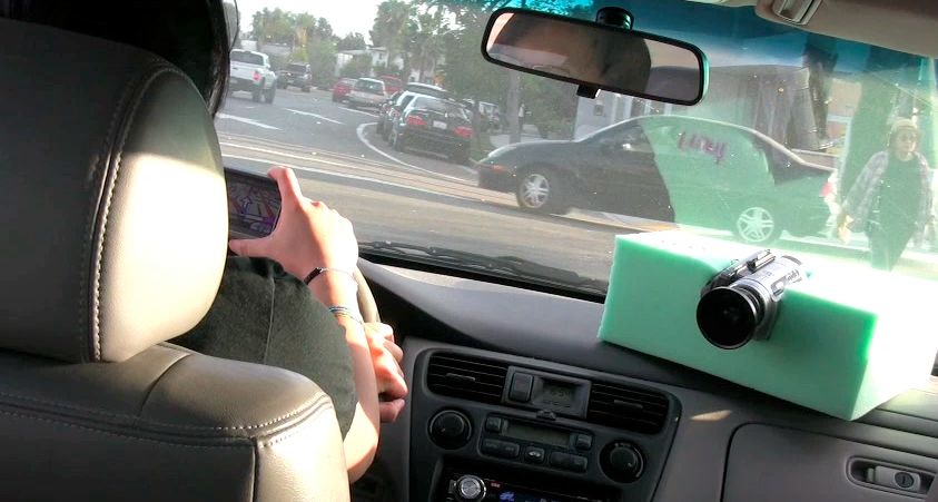
The popularity of GPS systems has helped to prompt spe-          sity, eleven of the drivers were students, and three were
cific attention to their design in HCI. For example, Schrei-     parents of students. The drivers were given video cameras
ber et al examined different designs of map displays, con-       and asked to record a journey they were taking where they
trasting congruency and the complexity of map displays           planned to use the assistance of GPS to get to their destina-
[30]. Hipp et al [13] documented how commercial GPS              tion. We fitted two cameras in each car, one capturing the
units frequently fail to provide directions that correspond      view out the windscreen (and the GPS), and a second point-
with driver intentions. They predict that 41% of navigation      ing at the driver and passengers. The drivers and passengers
commands given by GPS units are incorrect, in that they do       were themselves in charge of starting and stopping the cam-
not correspond with the driver’s intentions. Kun et al [18]      eras, and we did not meet with or interact with the drivers
explored how navigation systems distract drivers and lead        on the day of their journey. In total we collected data from
to driving errors, measuring errors in speed and car direc-      fifteen journeys (one driver recording two different trips),
tion between the use of spoken word and visual navigation        totaling just over 9 hours of video. Journey time ranged
units. Moving beyond existing systems Patel’s work ex-           from 13 minutes to 113 minutes, with an average trip time
plored how to simplify routes (‘route compression’) [28],        of 37 minutes. Four of the journeys involved drivers travel-
drawing on the everyday knowledge of drivers.                    ing on their own, with the remaining drivers having at least
                                                                 one additional passenger.
Much work around GPS makes use of experimental driving
simulators to test specific design conditions. For example,      The GPS units themselves varied - six journeys involved in
Medenica et al [25] tested the use of augmented reality GPS      car dashboard GPS systems, seven used portable, dedicated
systems with conventional map based GPS systems, finding         navigation-units, and two used smartphones’ navigation
broad benefits from the use of an augmented reality naviga-      applications. One limitation with this data is that all the data
tion system. Yet two recent CHI papers have explored the         was collected from driving in California, and although there
real world use of GPS while driving. Jensen et al’s [16]         is a mix of street and highway driving the environment
work examined the distraction and impact on driving of the       driven on is a distinctly North American urban and subur-
use of GPS units. In a controlled experiment drivers used        ban environment. We acknowledge there is a wide variety
in-car GPS units to drive to a provided location, with per-      of car wayfinding practices both internationally and in dif-
formance video-recorded and compared between conditions          ferent environments [33]. As part of the informed consent
with visual only, audio only, and visual and audio naviga-       for this project we advised drivers on the placement of the
tion information. They found that drivers performed better       cameras and their GPS so as to not interfere with their visi-
(drove more safely) in the audio only navigation condition.      bility. While none of the driving in our study was dangerous
                                                                 as such, some aspects were ill-advised (such as the hand-
Leshed et al’s [24] paper takes a qualitative approach to
                                                                 held use of the GPS unit in figure 1). To some extent this
documenting the use of GPS. This paper focuses for much
                                                                 may be unavoidable in a naturalistic study.
of its discussion on how GPS changes the engagement (and
disengagement) with the environment. This paper offers an        Along with the video data we also drew on an auto-
number of insightful points concerning the interactions          ethnographic component - the authors travelled on ten jour-
around the GPS by passengers and drivers, and how the unit       neys taking part as both passenger or driver, making use of
supports interaction both with the ‘virtual’ and actual physi-   GPS. At the end of each journey the authors wrote field
cal environment being navigated through. Drawing on              notes documenting their use of GPS, and any problems that
Borgmann they go beyond design to offer a fundamental            arose. This data was particularly valuable when combined
critique in that [GPS navigation] “demand[s] less skill and      with the video data, supporting the understanding of par-
attention by providing orientation and navigation as a com-      ticular incidents through reflection on the authors own ex-
modity, with instant availability, ubiquity, safety, and ease    periences.
of use, resulting in loss of engagement with the environ-        Our analytic approach builds on our earlier analyses of in-
ment and others”.                                                car conversation [21, 26] and in particular how directions
A broad engagement with driving and design is taken by           are shared through in-car conversations [20]. We drew on
Juhlin and his colleagues with research that spans analysis      interactional analysis [12] - focusing on the activities which
of driving to the development of in-car game systems that        took place around the task of navigation, both using GPS
support passenger experiences [17]. Juhlin’s fieldwork un-       and not. In individual and group data analysis sessions we
derlines the ways in which driving is a process whereby          surveyed the journeys, editing the 9 hours of video down to
road users “solve coordination problems with other road          75 one to two minute clips for focused analysis, of which 37
users [and] try to influence each other” [17, p49]. This work    were transcribed and analysed in depth. Our transcripts paid
positions driving as a form of social interaction on the road.   particular attention to interaction with the road, car and
                                                                 other drivers. We drew extensively on ethnomethodological
METHODS
                                                                 approaches to skilled practice - in particular Watson’s [33]
The data we collected was based on routes chosen by driv-
                                                                 work on driving and our earlier research into map use [4,
ers themselves, as part of journeys they would still have
                                                                 19]. We also drew upon phenomenological anthropology
taken if they had not been in our study. The drivers were not
                                                                 such as Ingold’s [14] discussion of engagement with the
asked to modify their driving or route in any way, apart
                                                                 environment. Our focus then was on the work of seeing and
from having cameras in their car recording their journey.
                                                                 movement in the world where GPS is only one resource
We recruited all fourteen drivers through our local univer-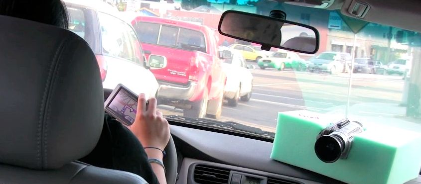
ditions and the road as they make the turn, they are not sim-
                                                                 ply following the GPS’s commands, but competently driv-
                                                                 ing - such as waiting to let the pedestrian cross the road.
                                                                 Second, the GPS actually changes its view (visible in the
                                                                 second frame) as the driver starts her turn, displaying the
                                                                 relevant instruction for after the current turn. While later
                                                                 relevant this offers an incorrect instruction for that exact
                                                                 point in time. This does not appear confusing to the driver
                                                                 as they continue to complete their turn. When the driver
                                                                 consulted the GPS - as the driver approached and started to
                                                                 execute the turn - GPS offered the ‘right’ instruction.
                                                                 Whatever the (potentially serious) safety implications of
                                                                 holding the GPS while driving the driver, the position of the
                                                                 GPS and the angle at which it is being held also complicate
                                                                 understanding of the GPS’s instructions in terms of a spe-
                                                                 cific road that the driver should manoeuvre the car down
                                                                 with the GPS is held at a range of angles. At this turn are
                                                                 four possible exits from the junction and as the car itself
                                                                 moves toward the turn the angles of the road and the GPS
                                                                 display add considerable ambiguity. Indeed, continuing
                                                                 ‘straight ahead’ would involve a slight turn to the right
                                                                 (visualised on the GPS as taking a 45 deg turn). The driver
               Figure 1: A turn with GPS.                        must thus do some ‘orientation work’ [19] so as to find and
          A video figure accompanies this paper.                 complete the correct turn.
                                                                 While this clip is straightforward the use of the GPS is
drawn upon alongside the controls and kinesthetics of the        clearly not without skill - the driver need select the correct
car and the perspectives on the environment emerging             road to turn down, ignore the GPS as it changes its display,
through driving into it. With this analytic focus on embod-      and manoeuvre the car while holding the GPS.
ied interactions with place and space, this work is in con-
trast with much of the existing literature on map use, focus-    Not following the GPS
ing on the role of cognitive representations of space [4, 10].   As a second extract from our data show how the use of the
                                                                 instructions from the GPS can be even more involved. As
RESULTS                                                          typical as extracts such as figure 1 are in our data, incidents
Driving with GPS, as with the skills of driving more             where drivers did not follow the GPS instruction were also
broadly, are commonplace and in many ways taken for              common (supporting Hipp et al’s claim that GPS instruc-
granted. Through close video analysis of driving we sought       tions are frequently not followed by drivers).
to render visible some of these skills we take for granted.
We start our analysis with two different clips which al-         For example, in figure two the passenger and driver are on
though both typical of the data display different characteris-   their way to a bar that is on the street “University Ave”. In
tics. The first shows how a seemingly straightforward turn       this extract the car is driving along a highway and ap-
can involve orientation work, following the GPS and ignor-       proaching a junction which offers turns to both University
ing an incorrect instructed turn. The second clip shows how      Ave (“exit 2C”) and Washington Street (exit “2B”). Here
using the GPS can involve not following the instructed turn      the driver decides to take a different turn from that sug-
yet still engaging with the instructions given.                  gested by the GPS - taking the car on exit 2C towards Uni-
                                                                 versity Ave (line 4). While the driver takes this earlier turn
Following the GPS                                                the GPS actually shows the car taking 2C until line 13. In
Figure one shows three frames from one extract where the         this case it is not that the GPS is ignored - indeed the driver
driver follows the instructions of the GPS to take a right       speaks soto voco to the GPS in line 7, and the passenger
hand turn. In this case the GPS is held in the hand of the       comments on the driver not following the recommended
driver. The GPS recommends that the driver take a right          turn (lines 11 & 12). There are a number of potential rea-
turn and in the second frame the driver has started their turn   sons for the driver making this earlier turn - he could be
but stopped to allow a pedestrian to cross the road. In the      choosing the ‘safe’ route - since this exit is signposted with
last frame the driver has completed their turn and continues     the street that is their final destination. The car also slows in
their journey. In some ways this turn is an unproblematic        traffic on approaching this junction, and the driver could be
example of following a turn with a GPS - perhaps familiar        choosing to avoid traffic.
from our own GPS use - the GPS gives an instruction for a
road maneuver, which the driver then follows. Yet even this      Whatever the exact reason the action is referred to by both
seemingly simple case reveals some subtle complexities.          driver and passenger in light of what the GPS is recom-
First, the driver needs to take into account the driving con-    mending. The driver comments that they are ‘going to go
                                                                 this way ‘n get lost’, in some ways doing a pre-emptive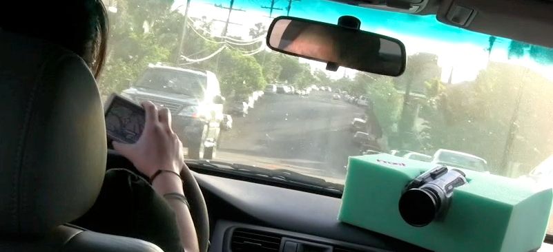
1. G: In about three quarters of a mile exit number 2 bee on your right then left turn
2.    ((section excluded))
3. D: We’re going to go this way ‘n                                      Exit 2B   Exit 2C
        get lost (4.0)
4.     ((Changes lane to the right, to             Exit 2B
        take exit 2C))
5. P: (4.0) I wz just gonna say just
        go over here
6. G: Exit number two b [*] on your
        right then-- left turn
7. D: Oo:: is that what happens
8.     (2.0)
9. D: Nope I took the wrong exit (1.) uh-oh
10. (4.0)
11. P: You do realise
12. D: [(I do realise)]
13. ((GPS shows car not taking turn))
14. P: [2B is right there] [*]-----------
15. P: ((points-[---------------[----))
16. D:       ((looks))   okay
17. G: In about quarter of a mile take
18. a left exit onto university avenue
19. D: okaey

  Figure 2: “2B is right there” In these transcripts, D is driver, P is passenger and G is GPS. Some of the transcripts
 involve lengthy discussions of other topics and so have been shorted for brevity. To aid understanding of some of the
     driving we have also inserted (marked with an [*]) images from the video, along images of the GPS display.

strike - if they do get lost then the driver did at least origi-   potential and recommended turns alongside close-by street
nally acknowledge the matter. Route choices are, after all,        names and other relevant information.
accountable matters where you can get into trouble for go-         However, as any prolonged exposure to a GPS will make
ing the wrong way [4] - indeed, in line 11 the passenger           clear, GPS units do frequently ‘make trouble’, in that their
goes on to question the drivers choice.                            sensors, maps or routes, fail to make sense to the driver, or
While complex these sorts of road junctions are relatively         offer obviously irrelevant instructions. Frequently the
commonplace - here the GPS offers clear instructions, in           source of these troubles not the GPS incorrectly determin-
good time, to take the instructed junction. The driver’s           ing some aspect of the world, but rather aspects of the
choice is not a mistake but is a deliberate decision. The          broader interaction with the technology. We call these
GPS, however, sticks on the original route even though by          events ‘normal troubles’ to indicate that while they are
line 4 the driver has positioned themselves to take a differ-      problems for drivers (they sometimes cause confusion or
ent lane, and by line 6 the car has entered an ‘exit only’         disorientation) and in some cases could be alleviated by
lane. The GPS still recommends the original, later, turn 2B        better designed technology, they are also ‘normal’ in that
onto Washington Street. In common with the first example           overcoming them is part of ordinary use of a GPS. Bittner
the GPS is not ignored, but the instructions it gives are read     and Garfinkel [3] describes “normal, natural troubles” as
with respect to the current road conditions and car position -     cases when a record of some sort (a file or a map) is put to a
the driver chooses to diverge from the given instruction.          purpose that could not have been foreseen when it was cre-
The instruction both creates a relevant occasion for the           ated. In this case, the driver must take the instructions and
driver’s decision-making but also provides relevant options        maps provided by the GPS and ‘fit‘ them with the situation
(following / not following the GPS). Using this information        they find themselves in. Competent GPS use thus involves
about the multiple junctions the driver can assume that it is      being able to overcome and deal with these ‘troubles’. We
still possible to reach the destination taking the alternative     outline five ‘normal troubles’ here: destinations, routes,
turn. The GPS also goes on to provide a resource for the           maps and sensors, timing and legality.
discussion between the driver and the passenger. Lastly,
whatever turn is taken by the driver he can be sure that the       1. Destinations
GPS will recalculate, and it has, by line 17, adjusted the         This is perhaps most clearly demonstrated if we consider
route; they will not “get lost”.                                   how destinations are dealt with by GPS systems. For exam-
                                                                   ple, in one journey the driver stops off on her route to pick
Normal, Natural GPS Troubles                                       up cupcakes for the event she is going to. As she diverts
Both these videos offer typical and uneventful examples of         from the original route the GPS continuously recommends
GPS-instructed action. In many cases in our video corpus           her to return to the original route. When she has finished her
the GPS would direct action ‘correctly’, even when the the         errand and is navigating to the destination that is set in the
driver chose a different turn from that recommended. The           GPS, the GPS then continues to recommend that she drives
GPS acted to provide alternative courses of action - with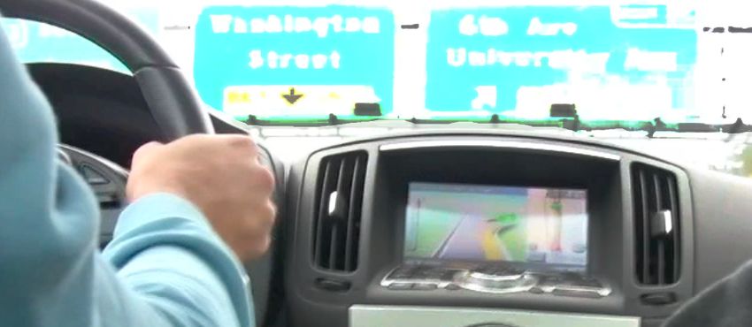
on the surface roads. Meantime she has taken her preferred        without complaint should the driver wander from the sug-
route along the freeway (comparing these routes there is no       gested route. Yet the persistent instruction to follow a dis-
significant difference in the time they will take). In an at-     carded route is an obvious irritant to drivers.
tempt to make the GPS software recalculate the route the
passenger sets the junction with the freeway as an interme-       2. Routes
diate stop. Unfortunately he sets the wrong junction which        As with destinations, the particular desired route that a
in turn results in a series of further incorrect directions be-   driver might take is also something with considerable vari-
ing given by the GPS. In many senses the GPS is not mak-          ety. Routes chosen by drivers do not simply take into ac-
ing a mistake here, since it could hardly guess about the         count what might be quickest, or the particular road type, or
cupcakes, or the choice of route. Yet, the end result pro-        predicted traffic, route choice is often heavily influenced by
vokes considerable frustration - the driver remarks, “these       route complexity. This is understandable since with each
GPS things it’s really confusing”, whereas the                    turn there is a possibility of making a mistake, so simpler
passenger is more succinct: “ahh shutup”.                         routes are preferred over more complex ones. Route selec-
                                                                  tion is also influenced by existing experiences on those
For drivers in many cases the destination may be deliber-         roads, quality of road and so on. A freeway might be pre-
ately and fruitfully ambiguous or approximate. Drivers and        ferred over a highway, even if the distance to and from the
passengers might only have a limited idea of their exact          freeway make it in slower, or a highway over a freeway for
destination, or know in some detail where they are heading        a less confident driver. Routes might be chosen to avoid
but be missing the address or zip code. Indeed, it is com-        dangerous roads, high crime neighborhoods, or to pass
mon enough for drivers or passengers to identify their final      through beautiful scenery or a favorite street. If a particular
destination from what they recognize when they get closer.        route has been navigated before (and is thus known to the
Also the the details of the destination may be reliant on in-     driver) it might be preferred to unknown streets.
formation that is not immediately available and might be
provided later (by calling to the destination, or by looking      GPS units use specific (and sometimes proprietary) algo-
up the address). The final destination might also be contin-      rithms to calculate routes, they are, on the whole, focused
gent on features of the environment of which the GPS is           on optimizing driving time. As a consequence GPS will
unaware. Cars need to be parked, for example, so the final        often chose a route which is complex, involve driving over
destination for the car rather than its occupants might be        roads which are difficult to drive on, or involve the naviga-
street parking distant from their actual destination.             tion of a complex junction, or have other qualities that make
                                                                  it a dis-preferred route by a human driver, even though it is
Thus the driver may choose to specified a destination to the      faster. This led to two ‘troubles’ for drivers in our corpus:
GPS not as where they actually heading, but what they can         dealing with a dis-preferred route, and a failure to under-
find rapidly in the GPS interface - as an approximation to        stand how the current instructed turn fits with what the
their final destination. For example, in the case above the       route is overall. When the GPS selected a dis-preferred
passenger sets the destination as a freeway junction, not         route drivers would struggle to understand how the recom-
because that is the final destination but because their de-       mended route differed from their own route choice and if
sired route involves the freeway. Drivers might also not          this highlighted a problem with their own route, or it was
specify a detour to the GPS. Seeing a shop from a freeway,        simply the GPS provoking the confusion:
for example, a driver might detour to go to that shop and
would be unlikely to bother to program this into the GPS.         G:    Continue point nine miles then turn
                                                                        right on west contello avenue
This divergence between the actual and specified destina-         P:    Yeah this isnt right
tion in turn has a corresponding effect on the route that the     D:    Well i guess you can keep going that way
GPS specifies. In some cases it will simply be irrelevant to            but
the driver. For example, in one of our recorded journeys, a       P:    I think this is only for local
driver turns off the freeway to get petrol - at which point the   D:    No GPS is not for local
GPS immediately commands her to turn and rejoin the               P:    No how it set up right now
                                                                  D:    That doesnt make sense
freeway. If a driver choose a different route from that the       P:    This what it did last time but it’s not.
GPS recommended that could cause considerable problems                  if if were gonna take a right on con-
- we observed ‘recalculating storms’ - where the GPS rec-               tillo then bu:we wouldn’t be going on
ommends that the driver return to the commanded route,                  the freeway
and ignorant of their own choice, recalculates on each junc-      D:    Yeah but it’ll still get you there
tion when they do not return to that route.                             adoonna why its (2.0) yeah
GPS systems have attempted to address some of these chal-                         Figure 3: Wrong route choice
lenges - such as by supporting the ability to have more
complex routes with multiple stops or the relatively easy         The second problem with routes involved cases when the
setting of detours to a route (such as finding a close gas        driver would not understand how a particular direction fit-
station on route). Indeed one of the great values of the GPS      ted into the broader route. In some cases passengers or driv-
over the human navigator, is that it offers an impressive         ers would interact with the GPS unit to try and inspect the
amount of fault tolerance. They will recalculate a new route      route. Getting a route overview while driving though ap-
                                                                  peared challenging. In this extract the passengers exchange
the numbers of different freeways trying to work out the         without the involvement of the passenger this could have
recommended route:                                               resulted in a missed turn:
D:    So i don’t think theres a ramp for the                     G:    In one point seven miles exit on Hancock
      six ohhhhh. fivve                                                Street
P:    I donno let’s be safe                                            ((section excluded))
D:    Sh:i would i wonder what route this                        D:    I go here. I go down this way a lot for
      thing is taking                                                  my off-campus stuff but in I haven’t
      ((P starts to use GPS))                                          seen a street called Hancock
G:    ((bleeps))                                                 P:
P:    Oh                                                               ((looking at GPS))
D:    [You have to click the name]                               D:    so I see Washington street do i just go
G:    [In eight point one miles] keep left                             [off]
      onto i four oh five north=                                 P:      [yeah] yeah go off on Washington
D:                  =aeh:                                              ((pass sign “Washington St 3/4 mile”))
P:    Six oh five=                                               G:    In point eight miles exit on Hancock
D:         =oakey                                                      street
D:    °One ten°
P:    Yeah one ten (six oh eight)                                               Figure 5: exit on Hancock street
D:    Yeah. alright (6.0)                                        While this error can be seen as a simple map error it also
G:    ((Beeps))
                                                                 illustrates the sometimes complex nature of street junctions
D:    Probably less
P:    When we end up on Exposition Boulevard                     - in this case a junction that leads to Hancock Street, but is
      we should try and find parking                             actually the ‘Washington street’ exit. It might seem reason-
                                                                 able to label a junction in terms of the street that it leads to,
                Figure 4: inspecting the route                   but incorrect in this case. Moreover, this is not something
Here the passengers are talking about the route to their des-    that would be properly represented on a map (Google maps,
tination. The GPS is taking them on a fairly convoluted          for example, show the street exiting onto Hancock). This is
route involving keeping on the i405 (which they are cur-         an example of a conceptual challenge that stands beyond
rently on), then taking the i605 then the i110. As the pas-      the significant practical one - how to accurately represent
senger inspects the route on the GPS she reads ‘605’, and        the vagaries of roads and junctions in a good enough way,
the driver reads a subsequent freeway - the ‘110’. By de-        without having to model everything about the world - as
fault most GPS systems only give the single next turn so         Wood puts it: “every map show this... but not that” [34].
here the passenger and driver interact with the GPS to bring     While in most cases the abstraction that the GPS uses - its
up a list of future turns, which they then inspect to make       map - is sufficient for navigation, drivers must always
sense of the recommended route. The comparison of routes         watch out for cases where the abstraction fails - ‘natural,
here is part of an inspection of the GPS’s chosen route:         normal troubles’. For example, in another video extract a
what route is the GPS taking and should they try and make        driver talks about how with GPS systems “it’s really con-
their own route? Has something gone wrong with the GPS           fusing sometimes, like the exit, the line doesn’t look like the
that they need to fix? While the GPS’s route is rather com-      exit". Even with improvements in graphics GPS systems
plex the travelers can assume that the GPS is applying ra-       struggle to portray junctions in a visual form such that
tional criteria, yet something might have gone wrong (such       makes it clear to drivers what junction to take.
as an out of date map, or an incorrect destination) so they      A related problem concerns the unavoidable inaccuracy of
need to be attentive to the GPS. Moreover, looking at the        the sensors that GPS systems rely upon. GPS signal can be
GPS’s complex route will mean that the driver is pre-            easily lost, or the orientation of the car can be ambiguous or
warned as to future turns, and allows them in the final line     simply wrong. Particularly at the beginning of journeys this
to move on to discussing parking at their destination.           can cause a confusing start - does the driver turn this way or
                                                                 that way? Perhaps even worse, sometimes GPS units do not
3. Maps and sensors                                              have enough confidence in their position and orientation to
One of the biggest challenges in providing a useful GPS          be able to give a route at-all - hardly something that engen-
system is the collection of accurate and up-to-date maps. As     dered confidence at the beginning of a journey. While this
new road are built, old roads removed, junctions and one-        inaccuracy can be misleading or lead to wrong turns, GPS
way systems altered, GPS units can struggle to keep accu-        systems are prone to more cosmetic errors. For example,
rate map data, particularly for units which need user inter-     where a driver takes a junction that has not been recom-
vention to be updated. Inaccuracies with maps can indeed         mended by the GPS - and the unit continues to show the car
cause problems for drivers. In this extract the driver is ini-   taking the recommended junction (e.g. figure 2).
tially confused by the GPS instructions to ‘exit on Hancock
street’. While the exit is actually ‘Washington street’, it      4. Timing
meets a second street called ‘Hancock street’ as it exits the    A related set of problems concern the timing of turn-
freeway. The street has thus been incorrectly labeled by the     instructions given. Reliant upon the limitations of the screen
GPS as ‘Hancock street / Washington street’, which the           and audio, the GPS must provide timely delivery of infor-
voice-instruction shortens to ‘Hancock street’. While subtle,    mation to the driver. One feature of driving is that for cer-
tain movements of the car sequence is important in that ure 4) - advising the driver to avoid an exit-only lane. While
certain movements change the possibility of movements this (in some cases) might be useful, for the competent
that can be made later - moving into a right hand lane freeway driver this is superfluous - understanding, and ex-
makes it easier to later take a right turn. Sometimes the po- pecting, exit-only lanes is part of US driving. More seri-
sitioning of the car must be done with an eye to turns that ously, since the GPS is giving this instruction it can occlude
are some distance away - particularly in highway driving the actual next turn that needs to be taken. In one case from
lane position is important for junctions. the corpus, the GPS does not tell the driver in time about
their next turn because it is busy telling them about a turn
In this clip the announcement of ‘take ramp on the right’
they should not take, causing the driver to have to quickly
has a different meaning as a new right hand lane appears to
react and change multiple lanes across the highway.
the right of the car after the instruction. The driver needs to
quickly move the car into the new right hand lane. If the
5. Legality and safety
GPS’s instructions had been given a second or so later, they
Our final ‘normal trouble’ concerns issues of legality and
would have been announced in conjunction with the new
GPS use. GPS units give, on the whole, legal navigation
lane (but perhaps too late for the driver to safely take the
information - it seems rather obvious that a GPS should not
turn). As the lane appears the driver and passenger ex-
instruct you to make a road manoeuvre that would be ille-
change a curse, and the driver quickly moves one more lane
gal. Yet in many cases this can conflict with manoeuvres
to the right so as to be able to take the ramp. The appear-
that are commonly practiced yet are, under a strict interpre-
ance of a ‘new’ right hand lane, after the original turn in-
tation, illegal. Juhlin [17] gives an example of breaking the
struction is given, is not modeled by the GPS which simply
speed limit on a slip road so as to be able to safely merge
states the need to take the turn. While this is in part timing,
with traffic on a highway. This is the ‘moral order’ of the
it is also an issue of the granularity of the model of the road:
road - situations where a driver would be exceedingly un-
likely to be prosecuted, or where safe driving implies break-
ing a traffic law [29].
A relevant example for GPS use concerns where a driver
would turn their car into a car park or business and would
cross the middle of the road to do so. If there is a line in the
middle of the highway this is an illegal road manoeuvre, yet
one that would be commonly taken by many drivers. To
G: In point three miles take ramp on right avoid the illegal move a GPS should recommend a circui-
to I four oh five north tous route around the block, rather than a simple turn. Yet
((new right hand lane becomes visible)) this leads to confusing directions being issued by the GPS.
D: oooops= As the driver approaches their destination the GPS directs
P: =shit [*] the driver to drive away from their destination and around
((white car in front changes lane to the block so they enter from the correct side of the road. A
right))
related problem concerns the speed that drivers cruise at on
D: ((looks right))
D: ((puts indicator on)) roads. Many (even most) drivers will frequently drive
D: ((looks right, indicates, changes lane)) slightly above the legal speed limit. On an empty road with
G: Take ramp on right to four oh five north a low speed limit, with no sign of other drivers (or police)
they may even choose to heavily exceed the set speed limit.
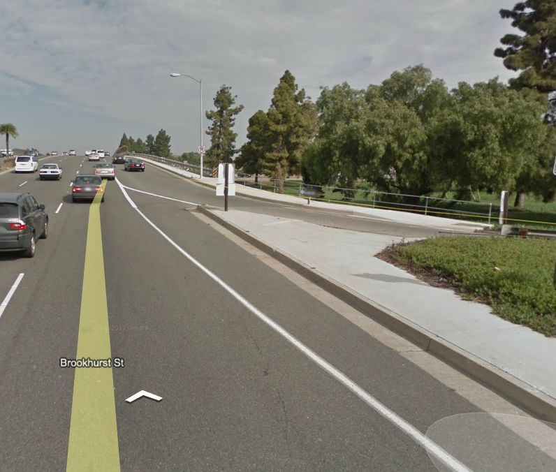
Figure 6: take ramp. Alongside the video frame above is a goo- This potential of fast and empty roads could not be used by
gle street view frame from the same position showing the new lane the GPS in calculating arrival times. The drivers we studied
appearing on the right, after the GPS instruction is given
thus ‘raced the GPS’, where they would seek to beat the
Questions of timing have particular importance at highway predicted arrival time by the GPS, something that entailed
junctions where decisions have to be made quickly, and the exceeding the speed limit (but still driving at the ‘natural
positioning of the car in a particular lane can be important speed’ of the road [17]).
long before the particular junction need be taken. In some Our data also speaks to questions of the safety of GPS use.
cases GPS units will provide information about a particular While we could not find any statistics for accidents caused
turning but will not inform the driver about the turn they by GPS-related distracted driving some experimental stud-
should take immediately after this turning. Often the driver ies have found GPS assisted driving degraded performance,
needs to position themselves in the correct lane on leaving particularly with the use of visual navigation aids [16, 25].
the highway, and the delivery of the information after the Other simulator data and experimental of navigation use has
first turn will be too late to be acted on by the driver. found GPS navigation while driving to be safer than using a
Alongside questions of timing, GPS units can, at times give paper map [23]. This situation is in some ways analogous to
superfluous instructions that confuse the driver, or occlude driver distraction through driving with a cellphone. While
the presentation of more pertinent and important informa- many legislatures have outlawed this practice, the empirical
tion. In a number of examples from the corpus the GPS evidence is somewhat unclear - simulator data suggests that
gives instructions to ‘keep left onto the highway’ (e.g. fig- driving with a cellphone is as dangerous as driving while
intoxicated [31] yet accident rates have been under a slowdecline in most western countries [2]. Moreover there ap- side view which lists future turns to be taken. This might
pears to be no correlation between cellphone use levels and alleviate problems of route occlusion and timing too, in that
accident rates [2] even as cellphone use while driving has at least a driver can choose to quickly ‘look ahead’ in the
declined in states that have banned the practice. route to see where they are heading. Issues of timing and
lane choice are more difficult to address, yet it may be pos-
An important problem is that experimental data on driving
sible that GPS units could make use of more advanced
suffers from ‘demand characteristics’ [5, 11], where driving
models of the current driving situation so as to offer more
in a test is organized in ways that make it differ from the
detailed instructions, or to ‘seamfully’ [6] reveal limitations
more everyday driving recorded here. While our data is still
in sensors or maps. While there has been considerable ad-
‘framed’ through its collection, the nature of its collection
vances using crowd sourced speed and map data it is possi-
makes for video that is more varied and natural that video
ble that drivers might be able (for example) to suggest areas
collected in simulators or experimental drives. Through
where instructions are unclear, or to correct difficult to fol-
relying on experimental data to study driving we may be
low instructions. Lastly, GPS units may offer the option to
missing driving as it is actually practiced. Nevile [27] clas-
avoid superfluous instructions - such as route guidance to
sify driver distraction using naturalistic data and document
‘keep on highway’ as an exit lane approaches.
this point in more detail. As Esbjörnsson et al [8] point out,
this has serious implications for the validity of simulator GPS use as skilled activity
and experimental based driving data presented at CHI. A broader analytic point, that may well be more productive
for design, is to understand the use of GPS as a form of
DISCUSSION
skilled activity, where drivers and passengers make use of
Drawing on the data here there are three arguments that we
GPS to support the driving activity. Rather than seeing this
make concerning the use and design of GPS systems for
as a case of ‘docile drivers’ who blindly follow the instruc-
driving. First, we draw a set of design recommendations
tions given, we can conceive of driving as a complex task
focusing on how GPS systems could better support the ex-
where drivers in different ways rely upon, inspect, fight
perience of driving. Second, we argue for a broader concep-
over and ignore the instructions given by the GPS. To sup-
tion of GPS use as a skilled activity. Lastly we discuss the
port usability the goal should not be simply ‘telling the
notion of ‘instructed action‘ and how we conceive of action
driver where to go’ but giving the driver the information
as directed by technology.
they need so as to satisfactorily get to their destination.
Informing the design of GPS systems
In many cases this would mean simply giving the driver a
It is clear that the design of GPS involves a range of diffi-
simple route to follow. Yet even here information about
cult trade-offs, optimising for one behaviour could cause a
other streets and the broader context of the city would not
range of conflicts with others. We described the troubles of
be irrelevant but part of providing contextual information to
our GPS users as ‘normal natural troubles’, to indicate that
help a driver make decisions about the turns they make.
they are not necessarily problems that are in need of techni-
Leshed et al [24] mention how the display of ‘points of in-
cal solution, since part of the skilled use of a GPS is over-
terest’ can better support interaction with the physical envi-
coming these problems. Moreover, any ‘recommendations
ronment. This paper echoes this point and raises the ques-
for design’ need to be couched in an acknowledgement of
tion of how a GPS might better support informed driving.
the astounding success of GPS systems and how they have
One could imagine a GPS unit designed not to instruct a
changed driving. Yet if we acknowledge some of the prob-
driver to a given destination but instead to teach them about
lems drivers face managing routes and destinations it is
the city they are driving through (on this point see [22]).
possible that GPS systems could present more choice to a
One might imagine a GPS mode which did away all to-
driver. For example, a secondary route could be shown on
gether with the notion of navigation, and instead sought to
the map in a lighter colour, or GPS units could offer the
assist and educate the driver without directing them to take
option of taking a simpler route rather than the time or dis-
a pre-determined route to their destination.
tance optimised route. As an extreme case a GPS might not
even offer a suggested route, but simply label streets in A second argument that Leshed et al’s refer to is that of
terms of how likely they are to get the driver closer to their Aporta and Higgs who analyse the use of snowmobiles and
destination. When driving, if a driver ignores a particular GPS amongst Inuit peoples. Aporta and Higgs argue that
turn then rather than attempt to instruct them back to the GPS is part of the commodification and deskilling of navi-
recalculated route, the GPS might take that turn as an indi- gation: “There is a sense of fulfilment and accomplishment
cation of a choice of a distinct, preferred route. Continual in being able to relate fully to the activity we perform and to
ignoring of the recommended route could even automati- the environment in which we are. GPS technology takes
cally silence the GPS’s audio instructions. that experience away” [1]. Yet as we have identified above,
it may be better to see the use of GPS as the revision of
More broadly, if we see the instructions given by the GPS
existing skills. After all, navigation with driving is an activ-
not simply as commands but also as information for the
ity already constrained by machines of many sorts (the car
driver we might seek ways to better inform the driver of the
itself, for one), and adding one more machine does not nec-
route chosen by the GPS. At the very least this would in-
essarily radically de-skill the activity. More prosaically, this
volve giving the driver or passenger quick access to a route
question of skill leads to issues of driver education. One
overview of up-and-coming turns so they can understand
interesting question is whether driving tests and examina-
the whole recommended route. A GPS unit could offer ations could contain lessons about the skills involved in the that can be brought to hand at the point of execution to act.
effective use of GPS units, educating drivers in how to ef- There is always the need for the active skillful construction
fectively use them in their driving. Knowing how to follow of action at the point of use - ‘instructed action’.
a GPS - and when not to follow its instructions - is surely an CONCLUSIONS
important part of modern road safety [7]. In this paper we review some aspects of how GPS units are
Instructed action used to support real-world navigation. Our key argument
A GPS offers a very particular form of ‘instructed action’ has to move away from the model of the ‘docile driver’ who
where drivers are in the situation of trying to understand unquestioningly follows the instructions that the GPS gives,
and read the instructions given making sense of the world to a notion of active drivers and passengers who are inter-
around them, the movement of the car and the surroundings. preting, ignoring, re-using instructions while also combin-
As Suchman (1987) argued instructions do not determine ing them with related information from the environment and
their own application since work needs to be done, in con- their own route knowledge. To establish this model we dis-
text, to produce action from the instructions. Understanding cussed five ‘troubles’ which GPS using drivers dealt with in
instructions involves following earlier commands, establish- response to turn-by-turn instructions. Each of these covered
ing the context for the current instruction, but also to be a different limitation and possible source of error in the in-
aware of the features of the materials being working with. structions GPS units give, and how they are followed.
One illustrative example Garfinkel [9] describes is assem- As we look to future developments in navigation technol-
bling a piece a chair making use of printed instructions. ogy it may be that GPS-assisted drivers lose certain skills,
When assembling a chair “what a particular instruction or that they become dependent on a particular technology.
means can only be seen at a certain point in the assembly While it is possible to romanticise maps and lament the loss
process drawing on orientation of your own body, the party of particular vernacular skills it is also possible to acknowl-
assembled chair and the parts you have left [...] the instruc- edge that with what are often assumed to be technologies
tions have a developing coherence as part of a course of that de-skill we then witness the birth of new skills and
action that they do not have as a page of instructions” [ibid, competences, and understand how these are changing and
p42] As with instructions so with maps - “recurrently, in developing as the technology itself changes [15]. Rather
vivo, maps and manuals present their users the in vivo wit- than adopt a critical approach here to the spread of a tech-
nessed incompetence of the text” [ibid, p205]. Instructions, nology that changes our perception of movement, our goal
on their own do nothing - they can only produce instructed has been to understand and document these new
action in situ, when they are brought to the world, with the technology-assisted forms of wayfinding. As with any com-
work of whoever it is following the instructions trying to plex technical activity the account we have given here is a
make sense of what a particular instruction means at a par- necessarily partial one - and one that is particularly routed
ticular point in time. in the driving conditions of the routes we studied. We hope
What this means in terms of GPS is that the situated instruc- however that we have succeeded in providing some oppor-
tions are not ‘simply’ instructions but are puzzle pieces that tunity for reconsidering the design and use of GPS systems.
must be assembled so that the driver has to make out what ACKNOWLEDGMENTS
they could mean, sometimes needing to make wrong ma- Many thanks to Allison Primack for help with the data col-
noeuvres to be able to do that, looking around, asking ques- lection. We also thank Alexandra Weilenmann, Alex Taylor,
tions of passengers, all to produce suitable instructed action. Michel Alders and Jasper Michiel van Hemert for valuable
In many cases this will be easy or trivial - just taking a turn, comments on earlier drafts. We also thank audiences at Mi-
yet even in these cases this is not without skill. At other crosoft Research Cambridge and TomTom for discussions
times drivers are not able to understand the GPS at all, and on the paper and our data.
resort to abandoning its use, or even abandoning their jour-
ney. GPS is usable as a technology in how its navigation REFERENCES
commands are followed as instructions and that is not sim- 1. Aporta, C., Higgs, E., et al. Satellite culture: Global
ply doing what you are told. The user needs to listen to the positioning systems, Inuit wayfinding, and the need for
command given, and make sense of it in terms of their own a new account of technology. Commentaries. Author's
expectations and predictions about what the GPS unit has reply. Current Anthropology, 46, 5 (2005), 729-753.
calculated and the limited plan it is offering. Each instruc- 2. Bhargava, S. and Pathania, V. Driving Under the (cellu-
tion is taken not only then as a command but also as more lar) Inflence: The Link Between Cell Phone Use and
evidence about what the GPS is attempting to do, and Vehicle Crashes. Reg-Markets Center Working Paper
whether this fits with what the driver is trying to do. The No. 07-15. Available at SSRN:
instructions are then open to re-analysis, re-interpretation http://ssrn.com/abstract=1089081(2007).
and re-use as the car moves through the environment, with
3. Bittner, E. and Garfinkel, H. Good organisational rea-
each instruction, and each road passed providing informa-
sons for bad clinical records. In Studies in Ethnometh-
tion that can help the driver decide what to do next.
odology, Prentice Hall (1967).
As a broader point, ‘following instructions’ given by ma-
4. Brown, B. and Laurier, E. Maps & journeying : an eth-
chines rests not simply on how well the instructions are nomethodological approach. Cartographica, 4, 3
written or formed, but broadly on the skills and resources (2005), 17-33.5. Brown, B., Reeves, S., et al. Into the wild: Challenges 20. Laurier, E., Brown, B., et al. What it means to change
and opportunities for field trial methods. In Proceedings lanes: actions, emotions and wayfinding in the family
of SIGCHI Conference on Human Factors in Comput- car. Semiotica(In Press).
ing Systems (CHI), ACM Press (2011). 21. Laurier, E., Lorimer, H., et al. Driving and "passenger-
6. Chalmers, M. and Galani, A. Seamful Interweaving: ing": notes on the ordinary organization of car travel.
Heterogeneity in the Theory and Design of Interactive Mobilities, 3, 1 (2008), 1-23.
Systems. In Proceedings of DIS 2004, Boston, Mass., 22. Lee, J., Forlizzi, J., et al. Iterative design of MOVE: A
ACM Press (2004). situationally appropriate vehicle navigation system. Int.
7. Clark, K. The GPS: A fatally misleading travel compan- J. Hum.-Comput. Stud., 66, 3 (2008), 198-215.
ion. Morning Edition, 26th July, NPR. 23. Lee, W. C. and Cheng, B. W. Effects of using a portable
http://www.npr.org/2011/07/26/137646147/the-gps-a-fat navigation system and paper map in real driving. Acci-
ally-misleading-travel-companion (2011). dent Analysis & Prevention, 40, 1 (2008), 303-308.
8. Esbjörnsson, M., Juhlin, O., et al. Drivers Using Mobile 24. Leshed, G., Velden, T., et al. In-car gps navigation: en-
Phones in Traffic: An Ethnographic Study of Interac- gagement with and disengagement from the environ-
tional Adaptation. International journal of human- ment. In Proceeding of the twenty-sixth annual SIGCHI
computer studies, 22, 1-2 (2007). conference on Human factors in computing systems
9. Garfinkel, H. Ethnomethodology's Program. Rowman (2008),1675-1684 ACM.
& Littlefield, 2002. 25. Medenica, Z., Kun, A. L., et al. Augmented Reality vs.
10. Golledge, R. G. and Stimson, R. J. Spatial Behaviour: a Street Views: A Driving Simulator Study Comparing
geographic perspective. Guilford Press, New York, Two Emerging Navigation Aids. In Proceedings of Mo-
1997. bileHCI 2011, ACM Press (2011).
11. Haigney, D., Taylor, R., et al. Concurrent mobile (cellu- 26. Mondada, L. Mobile conversations: talking and driving
lar) phone use and driving performance: task demand in the car. Semiotica(In Press).
characteristics and compensatory processes. Transpor- 27. Nevile, M. and Haddington, P. In-car distractions and
tation Research Part F: Traffic Psychology and Behav- their impact on driving activites. Australian Road Safety
iour, 3, 3 (2000), 113-121. Report RSGR 2010-001. Available online:
12. Heath, C. and Luff, P. Technology in action. Cambridge http://www.infrastructure.gov.au/roads/safety/publicatio
university press, Cambridge, 2000. ns/2010/pdf/rsgr_2010001.pdf(2010).
13. Hipp, M., Schaub, F., et al. Interaction weaknesses of 28. Patel, K., Chen, M. Y., et al. Personalizing routes. In
personal navigation devices. In Proceedings of the In- Proceedings of the 19th annual ACM symposium on
ternational Conference on Automotive User Interfaces User interface software and technology (2006),187-190
(2010),129-136 ACM. ACM.
14. Ingold, T. The perception of the environment: essays on 29. Rothe, J. P. Beyond traffic safety. Transaction publish-
livelihood, dwelling and skill. Psychology Press, 2000. ers, 1994.
15. Ingold, T. Beyond biology and culture. The meaning of 30. Schreiber, J. Bridging the gap between useful and aes-
evolution in a relational world. Social anthropology, 12, thetic maps in car navigation systems. In Proceedings of
2 (2004), 209-221. the 11th International Conference on Human-Computer
Interaction with Mobile Devices and Services (2009),1-
16. Jensen, B. S., Skov, M. B., et al. Studying driver atten-
4 ACM.
tion and behaviour for three configurations of GPS
navigation in real traffic driving. In Proceedings of CHI 31. Strayer, D. L., Drews, F. A., et al. A comparison of the
2010 (2010),1271-1280 ACM. cell phone driver and the drunk driver. Human factors:
The journal of the human factors and ergonomics soci-
17. Juhlin, O. Social Media on the Road. Springer London,
ety, 48, 2 (2006), 381.
2010.
32. Suchman, L. Plans and situated actions: The problem of
18. Kun, A. L., Paek, T., et al. Glancing at personal naviga-
human-machine communication. Cambridge University
tion devices can affect driving: experimental results and
Press, Cambridge, 1987.
design implications. In Proceedings of the 1st Interna-
tional Conference on Automotive User Interfaces and 33. Watson, R. Driving in forest and moutains: a pure and
Interactive Vehicular Applications (2009),129-136 applied ethnography. Ethnographic studies, 3, 50-60
ACM. (1999).
19. Laurier, E. and Brown, B. Rotating maps and readers: 34. Wood, D. The power of maps. The Guilford press, New
praxiological aspects of alignment and orientation. York, 1992.
Transactions of the Institute of British Geographers, 33,
2 (2008), 201-216.You can also read