The Republic of Indonesia Territorial Atlas as Geo-literation Tools for the Adolescents - ICA-Proc
←
→
Page content transcription
If your browser does not render page correctly, please read the page content below
The Republic of Indonesia Territorial Atlas as Geo-literation
Tools for the Adolescents
Fakhruddin Mustofa a,*, Ellen Suryanegara b,*, Niendyawati c, Mulyanto Darmawan d
a Geospatial Information Agency, The Republic of Indonesia, uddin_mustofa@yahoo.com
b Geospatial Information Agency, The Republic of Indonesia, ellen.surya@gmail.com
c Geospatial Information Agency, The Republic of Indonesia, niendya_salam@yahoo.co.id
d Geospatial Information Agency, The Republic of Indonesia, drmoel2011@gmail.com

* Corresponding author

Abstract:

As an independent country and has a long history that forms The Unitary State of The Republic of Indonesia,
introduction to the territory and history is very necessary for Indonesia's young generation, especially for adolescents.
Various efforts were made by the Government of Indonesia to provide a territorial comprehension in order to make the
younger generation understand about the circumstances of their country. One effective way is through Territorial Atlas
of The Republic of Indonesia, which is the result from collaboration project between Geospatial Information Agency
and Ministry of Education and Culture of Indonesia. This atlas is intended towards the benefit of teenage children, who
are taking middle education level between the ages of 12-15 years. It is necessary for children at that age to be equipped
with spatial intelligence related to the territorial comprehension of Indonesia, the historical development of the
Republic of Indonesia, and also the natural resources potential of their country.

This comprehension is needed considering that adolescence is a vulnerable age who require self-actualization, so they
need to get a correct understanding of the NKRI region in order to foster the sense of nationalism. On the other hand,
the important reason for production the Territorial Atlas is due to the rapid growth of development and the
administrative area expansion, especially since the era of regional autonomy, was applied. Furthermore, another reason
is that the atlases on the market were not up to date and geometrically did not obey the cartographic principle
appropriately. This will cause a misconception for the reader, especially students in the middle school if they receive
incorrect information.

Therefore, it is important to produce a territorial atlas that uses the mapping principle and correct geospatial data and
information. The method used in production the territorial atlas is using the GIS method complemented by literature
studies and focused group discussions with education and geospatial experts. In general, the atlas is a compilation of
coherent and comprehensive geospatial information regarding 34 provinces in Indonesia, the history of the Republic of
Indonesia, introduction of neighboring countries and also equipped with narratives and interesting photographs/images.

The results of this activity are in the form of The Republic of Indonesia Territorial Atlas which has been adjusted based
on the applicable curriculum and will be disseminated to approximately 3,500 Junior High Schools in all regions of
Indonesia in print and digital format. It is expected that through the atlas, the spatial comprehension of young people
towards the NKRI region will be better and easier.
Keywords: atlas, education, geospatial, geo-literation, region, territorial

                                                                     for Indonesia's young generation, especially for
1. Introduction                                                      adolescents. At this time there was a significant
      The Unitary State of the Republic of Indonesia was             development in physical, emotional, personality, social,
declared as an independent region on August 17, 1945,                moral, and intellectual. This development is an important
through a long struggle of the people. Indonesia is also an          process of forming one's self construct in a family
Archipelagic State which shares its borders with 10 other            environment or society in general.
countries and territories; namely, Malaysia, Papua New                     The adolescent needs to be provided with spatial
Guinea, Timor-Leste, India, Thailand, Singapore,                     intelligence related to territorial and historical
Vietnam, The Philippines, Palau, and Australia.                      comprehension about the civilization of Indonesian
Therefore, as a sovereign country and has a long history             people. Both of them inseparable from the geographical
that forms the Unitary State of the Republic of Indonesia,           characteristic, natural resources potency, social-culture,
introduction of the territory and history is very necessary          as well as the disaster problems in Indonesia. This

Proceedings of the International Cartographic Association, 2, 2019.
29th International Cartographic Conference (ICC 2019), 15–20 July 2019, Tokyo, Japan. This contribution underwent
single-blind peer review based on submitted abstracts. https://doi.org/10.5194/ica-proc-2-90-2019 | © Authors 2019. CC BY 4.0 License.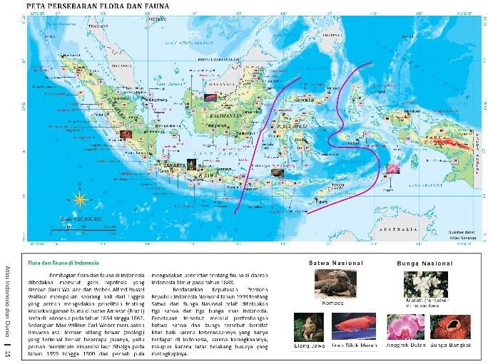
2 of 8

comprehension is needed considering the adolescents are              gate that makes students it easier to understand about a
in a vulnerable age and need self-actualization, so it               region, alongside wall map products as the other
needs to get a correct understanding of the Indonesian               geographical teaching instrument. Teaching instrument is
region.                                                              a tool to assist in conducting interactions with students
      Spatial intelligence can be optimized through                  and to facilitate students to understand the lessons that
education. Spatial education needs to be intensified by              must be mastered, which in the end is expected to
educators and those who engaged in geospatial                        improve the quality of learning outcomes. Moreover,
information or earth science. Geospatial information is              education in mapping and geography forms part of the
one of the important sciences for the development of                 process of establishing a map-conscious society (Klaas
human resources, especially for the next generation in               Villanueva, Proceedings of ICA 1997).
order to add knowledge about their archipelagos insights.                  Therefore, it is important to produce a territorial and
This will encourage an increase in geographical literacy.            historical atlas that uses the cartographic principle and
      Various efforts have been made by the Government               correct geospatial data and information. This is
of Indonesia to provide comprehension of territorial                 considering the atlas circulating on the market is not up to
aspects so that the younger generation can better                    date and geometrically did not obey the cartographic
understand the circumstances of the country. Since 2016,             principle appropriately. The producers and publishers of
the Government of Indonesia through the Ministry of                  maps and atlases on the market also did not concern
Education and Culture has intensified the National                   towards the compatibility level of the content material to
Literacy Movement as part of the implementation of the               the applicable curriculum. The rapid growth of
Minister of Education and Culture Regulation No. 23 of               development and the administrative area expansion,
2015 concerning the Character Enhancement. One of the                especially since the era of regional autonomy was
goals of the National Literacy Movement initiated by the             implemented, also encouraged an increase in the need for
government towards the adolescent is to understand and               the latest geospatial information.
empathize with the living space around them. Geo-                          Because of this matter, Geospatial Information
literation itself is the ability to process and understand the       Agency with the Ministry of Education and Culture of the
information of the surrounding space while performing                Republic of Indonesia collaborated to produce the
reading and writing in geography.                                    Regional and History Atlas of the Republic of Indonesia
      According         to     Indonesian      Comprehensive         in accordance with the curriculum, in this case, it is
Dictionary, literacy is the ability to write and read, the           Junior High School curriculum. This is in accordance
ability of individuals to process information and                    with the definition of adolescence by Hurlock (1980)
knowledge for life skills. Literacy is also knowledge or             which divides adolescence period into two parts, that is
skills in certain fields or activities. Therefore, Geo-              early adolescence and late adolescence. Early
literation in this matter referred to the ability of                 adolescence lasts around the age of 13 to 16 or 17 years.
individuals to process information and knowledge or                  Thus in general, Junior High School students are grouped
skills in the field of geography or geoscience to improve            in early adolescence. The goals of this research are:
the quality of life.                                                      • Mapping Indonesia's territory and history in a
      According to Bachtiar (2018), geo-literation                           structured manner; and
provides an understanding of where people live, how                       • Arrange thematic maps of territory and history
people are connected with other people in many places,                       into an atlas as an educational instrument for
these are expected to be a source of inspiration in                          Junior High School students.
developing personalities and fostering a supported
feeling, developing the value of citizenship that love the
nation. Geo-literation also bridges comprehensions of                2. Materials and Method
rules that absolutely obeyed by its citizens. Geography is           2.1. Conceptual Framework
more as a catalyst that can facilitate to absorb the                 Cartography
understanding of self-identity and other people, about the                 Taylor, 1991 (in Kraak & Ormeling, 2003) defines
differences between various national cultures in various             cartography as "the organization, presentation,
parts of the world to achieve peaceful coexistence in                communication and use of geo-information in the form of
diverse societies. This is in accordance with National               graphics, digital or tangible formats. It can cover all steps
Geographic (2012) that adopted geo-literacy as a new                 from data preparation to the end user by creating maps
term for a long-standing idea consisting of three                    and results related to spatial information". The
components:         interactions,     interconnections,   and        implementation of cartographic principles is also needed
implications. It is the ability to use geographic                    to minimize the misinterpretation of original information
understanding and geographic reasoning to make far-                  in the form of spatial data.
reaching decisions.
      One effective way to improve the geo-literation                Atlas of Education
capabilities in society, especially in adolescents, is
through increasing the quality of educational books                        An atlas is a systematic and coherent collection of
related to geoscience, one of which is Atlas. Atlas is one           geographical data, in analogue or digital representing a
of the educational instrument which becomes the front                particular area and/or narrative, together with tools for

Proceedings of the International Cartographic Association, 2, 2019.
29th International Cartographic Conference (ICC 2019), 15–20 July 2019, Tokyo, Japan. This contribution underwent
single-blind peer review based on submitted abstracts. https://doi.org/10.5194/ica-proc-2-90-2019 | © Authors 2019. CC BY 4.0 License.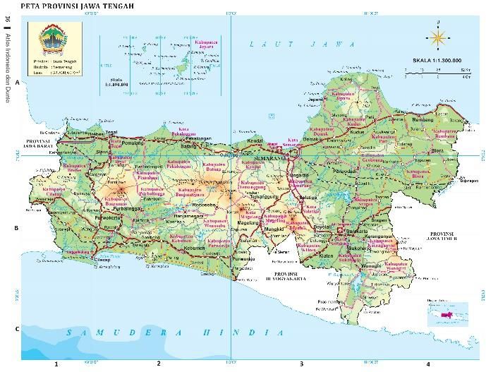
3 of 8

navigation, information retrieval, analysis and                           The Social Sciences material in 9th grade discussed
presentation (Koop, 1993). Ormeling on ACI Proceeding                towards the patterns and shapes of the earth's surface, the
(1998), stated Atlas structure refers to the basic                   geography of Southeast Asia, along with the continents
framework according to wich the maps have been                       and oceans. Regarding history, the material discussed
incorporated in the atlas. It is based on the emphasis on            towards the impact of World War II for Indonesia, the
specific areas or map themes and on the sequence in                  struggle to defend Indonesia's independence, the political
which these maps follow each other.                                  and economic events of Indonesia post recognition of
     School atlas is an atlas produced for educational               sovereignty, the struggle of the Indonesian nation to
purposes. Cartographic requirements for school atlases               defend West Irian, the events of the national tragedy, the
are the structures should follow the school curriculum.              end of the New Order and the birth of Reform Era, and
The emphasis on specific area and themes should also                 about international institutions and the role of Indonesia.
follow the directives of the educational authorities
(Ormeling, 1998).                                                    2.2. Method
                                                                           The method used in this research to produce
Junior High School Curriculum on Social Sciences                     Territorial and Historical Atlas is using the Geographic
      The education curriculum in Indonesia is currently             Information System (GIS) software. Furthermore, this
arranged and developed using learning strategies with                research complemented by literature studies Focus Group
contextual approaches, namely Contextual Teaching and                Discussions (FGD) with Junior High School education
Learning (CTL). CTL is a learning concept that helps                 experts along with geography and history experts. The
teachers and students in linking subjects that is                    base map used is the Indonesian Topographic Scale 1:
taught/learned with real situations in their learning                250,000. The design and layout process of the atlas book
environment. Like other learning strategies, contextual              is done using Adobe InDesign software. The general flow
learning is developed with the aim that learning can be              of atlas production can be seen in the picture below.
more productive and meaningful without having to
change the curriculum and existing order (Setiawan et al.,
2016). In the Junior High School Curriculum on Social                                                Non spatial Data, primary dan
                                                                            Base                             secondary data
Sciences, the learning material is presented in an
                                                                            Map                      (Statistic data, satellite image,
integrated manner, not separated in the field of science of
Geography, History, Economics, or Sociology.                                                             picture, narrative text)
Geography is used as a basis considering all events and
activities bound by location. The aim is to emphasize the              Working Map per
                                                                           Region
importance of spatial connectivity in strengthening the
nation. Historical, sociological, cultural and economic
studies are presented to support the formation of stronger
connectivity. Junior High School consists of 3 levels of                   Regional and Historical                  FGD
education, 7th, 8th, and 9th Grade. Each level has a                          Thematic Maps
different level of social science study.
7th Grade Social Science Curriculum
                                                                                        Atlas Compilation
      In 7th grade, the subject discussed towards the
explanation of maps, atlases, and globe, forms of the
earth, geographical conditions and population of
Indonesia, symptoms in the atmosphere and hydrosphere,
land use and economic activities. Regarding history,                                 Printing Test &
                                                                                   Readability Trial-Test
learning materials for 7th grade are studying about life in
the prehistoric period in Indonesia, the development of                                                             Final Revision
society during the Hindu-Buddha era until the Islamic
period in Indonesia and the development of society in                                   Atlas Production
European colonial period.
8th Grade Social Science Curriculum
      Learning materials of social science in 8th grade is                               Distribution &
                                                                                         Dissemination
the physical condition of the geographical area with
population activities, the development of colonialism and
                                                                     Figure 1. General Flowchart of the Atlas Production Method
western imperialism, history of the formation process of
national awareness and the development of the
Indonesian national movement, events circa proclamation              3. Results and Discussions
era and formation of the Republic of Indonesia, and
preparation for Indonesian independence.                                 The production of Territorial and Historical Atlas
                                                                     has a strategic meaning because it combines two
9th Grade Social Science Curriculum
                                                                     dimensions, which is spatial (space) and time. The spatial

Proceedings of the International Cartographic Association, 2, 2019.
29th International Cartographic Conference (ICC 2019), 15–20 July 2019, Tokyo, Japan. This contribution underwent
single-blind peer review based on submitted abstracts. https://doi.org/10.5194/ica-proc-2-90-2019 | © Authors 2019. CC BY 4.0 License.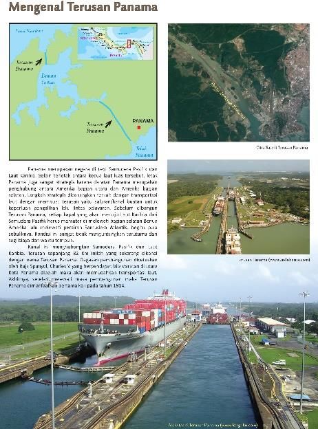
4 of 8
dimension means describing the circumstances of Indonesian topographic maps can be seen in the picture
territory, both the physical and the resources above it, below.
while the dimension of time means informing each event
within a certain time frame presented in the map. Both
information is very useful as literacy materials for
educational purposes.
In general, compulsory education in Indonesia is
divided into 3 levels, namely Elementary School (6
years), Junior High School (3 years), and Senior High
School (3 years). The necessity for geospatial and
historical information at those various levels is
formulated in a national curriculum. Two basic things in
the curriculum are core competencies and basic
competencies. Core competencies are related to the
nature of learning, while basic competencies are technical
operations.
Geospatial information directly supports the various
levels of education in Indonesia. The results of this study Figure 2. Examples of Indonesian natural resources base map
focused on the support of geospatial information for
junior high schools in the form of Atlas. There are two
key related to the importance of atlas to be part of
learning literacy in the class, the first is to understand the
spatial aspects and connectivity between spaces, the
second is to understand the history from prehistoric
period until the Reform Era. These are the fundamental
part of the themes that will be presented in the atlas.
3.1. Making Basic (Working) Maps
The base map becomes the first part of the atlas
production. The basic map obtained from the Indonesian
Topographical Map scale 1:250,000. This map has 8
elements, which is coastlines, hypsography/contours,
waters, topographical names/ toponym, boundaries,
transportation and utilities, buildings and public facilities,
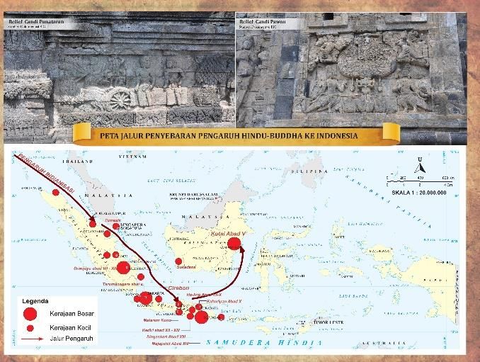
and land cover. Related to the atlas production, some of Figure 3. Example of Central Java Province base map
these layers are chosen based on the purpose. For
example for coastlines, hypsography/contours, waters,
topographical names/toponyms, territory boundaries,
transportation and utilities, are selected to produce
Indonesian map and the 34 provinces. For historical
maps, the elements chosen are generally coastlines,
administrative boundaries, and toponyms.
Students are also introduced to information of the
world and Indonesian regional through maps. The
database is obtained from world Shuttle Radar
Topography Mission (SRTM) in low resolution and
unpaid shapefile data. The working map is compiled from
both data, then a generalization process is carried out to
produce world map information, continental maps, and
maps of the Southeast Asian region. The introduction of
areas outside the country of Indonesia is very important
because in the Junior High School curriculum it is
necessary to understand the spatial aspects and Figure 4. Examples of thematic aspects of history base map
connectivity between regions. Some world objects related
to well-known regions were also presented as literacy
3.2. Territorial and Historical Atlas Structure
materials, for example, the introduction of the Panama
Canal and the Suez Canal. Both canals are the arteries Atlas is a structured, coherent, and comprehensive
between the world's main waters. Examples of basic geospatial information of particular thematics. Atlas is
maps for the atlas that have been processed from not just a stack of maps that are not connected to each
Proceedings of the International Cartographic Association, 2, 2019.
29th International Cartographic Conference (ICC 2019), 15–20 July 2019, Tokyo, Japan. This contribution underwent
single-blind peer review based on submitted abstracts. https://doi.org/10.5194/ica-proc-2-90-2019 | © Authors 2019. CC BY 4.0 License.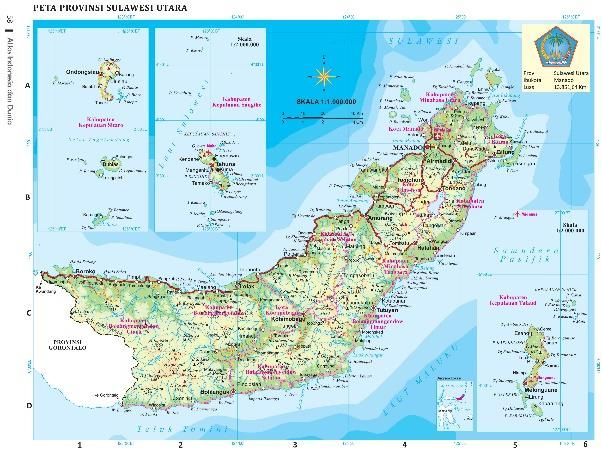
5 of 8

  other. This is the advantage of atlas compared to map                Section            Main Theme
  which only contained one theme information.                                             - Author List
        Territorial and Historical Atlas are built with                                   - Table of Contents
  ordered structures that are connected to each other. This            Preliminary        - Greetings
  is attempted to improve students' understanding of the                                  - How to read maps
  territory and history of Indonesia in accordance with the                               - General Legend
  development of age and level of knowledge. The                                          - Prehistoric Period
  Territorial Atlas structure begins with the introduction of                             - Classical Indonesia: Hindu-Buddhist
  the Indonesian territory and its natural resources,                                       Cultural Era
  followed by an understanding of the large islands namely                                - Classical Indonesia: Islamic Cultural
  Sumatra, Java, Kalimantan, Sulawesi, Central Nusa                                         Era
                                                                       Indonesian
  Tenggara, Maluku Islands, and Papua. For Historical                                     - European Colonialization Period
                                                                       Historical
  Atlas, the structure was built based on the periodization                               - National Awakening Period
                                                                       Periodization
  of the historical period in Indonesia. The structure of                                 - Japanese Occupation Period
  Territorial and Historical Atlas is generally arranged as                               - Revolution to Defend Independency
  follows.                                                                                  Period
                                                                                          - National & International Events after
                                                                                            independence
Section             Main Theme
                    - Author List                                    Table 2. Historical Atlas Structure
                    - Table of Contents
Preliminary         - Greetings                                              In some particular pages, students are introduced to
                    - How to read maps                                 important additional information. As an example is the
                    - General Legend                                   existence of the Suez and Panama Canal. It is expected
                    - Indonesian Map                                   that regionally, students will recognize the connectivity
                    - Administrative Map                               between the continents and the wide ocean through
Introduction to     - Population map                                   understanding information about the two Canal. The
Regional            - Rainfall Map                                     word 'connectivity between spaces' is one of the mandates
Resource Maps       - Flora and Fauna Distribution Map                 in the 2013 Education Curriculum that applies in
                    - Volcanoes Distribution Map                       Indonesia.
                    - Mineral & Energy Resources Map
                    - Mainland Maps (Sumatra, Java,
                      Kalimantan, Sulawesi, Bali
Indonesian
                      Nusatenggara, Maluku Islands, and
Regional Maps
                      Papua)
                    - Provincial Maps (each 34 province)
                    - Wolrd Map
                    - European map
                    - Asia
World Regional
                    - Australia
Maps
                    - Afrika
                    - Amerika
                    - South East Asia
Table 1. Territorial Atlas Structure

                                                                       Figure 6. Introduction of the Suez Canal

  Figure 5. Examples of Map Reading Instrukctions

  Proceedings of the International Cartographic Association, 2, 2019.
  29th International Cartographic Conference (ICC 2019), 15–20 July 2019, Tokyo, Japan. This contribution underwent
  single-blind peer review based on submitted abstracts. https://doi.org/10.5194/ica-proc-2-90-2019 | © Authors 2019. CC BY 4.0 License.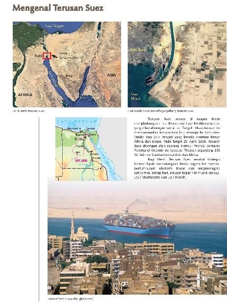
6 of 8

                                                                     used by the technical team of the Geospatial Information
                                                                     Agency. This format can be integrated with other
                                                                     thematic maps that have the same coordinate reference.
                                                                     This means that the maps in this atlas can be input to the
                                                                     process of analyzing in further research.
                                                                            In the context of forming map layouts, a
                                                                     combination of science and cartographic art is used.
                                                                     Important elements in a map are not neglected such as
                                                                     titles, legend, north direction, scale, coordinates, and
                                                                     other elements (see Figure 2 to 4, the map of Indonesia,
                                                                     Central Java, and history). In certain pages, inserted other
                                                                     graphic information in the form of field photos and
                                                                     satellite imagery. The photos selection is based on the
                                                                     strategic value and uniqueness of the regional and
                                                                     historical themes displayed. For example, Indonesia is
                                                                     traversed by an imaginary line of the Equator so the
                                                                     photo displayed is the Equator Monument in the City of
Figure 7. Introduction of the Panama Canal                           Pontianak at coordinates 00 00 '00 "and 109 o 19o 20o E.

3.3. Focus Group Discussion (FGD)
      To produce a quality atlas, it requires the
involvement of experts in cartographic, geospatial,
historians, graphic design, and Junior High School
teachers/educators to formulate concepts and proceed to
the technicalities of making an atlas. Focus group
discussions are a method of exchanging ideas/knowledge
and sharing information about updated regional
conditions, full-fledged/official history information, and
the suitability of the themes with the applicable Junior
High School curriculum.
      The discussion is held regularly every three weeks
in a period of 6 months. Each informant gave input in                Figure 9. North Sulawesi Province
descriptive and narrative concepts, then operationalized
by the map team into geospatial information. This is
considering that the results of spatial data presentation,
especially those relating to historical data, need to be
evaluated by experts to check and read up whether the
interpretation of historical data from a phenomenon has
been correct and accurately pictured in the form of spatial
data.

Figure 8. FGD for Atlas production                                   Figure 10. The distance of Miangas Island is closer to the
                                                                                Philipines

3.4. Database, Map Layout, and Atlas Presentation                         The satellite images selection that displayed in the
     The databases of maps in the atlas are arranged                 atlas consider the strategic value of the object. For
using the gdb (geodatabase) and shp (shapefile) formats.             example Map of Sulawesi Province. This province has
Both systems are standard database formats that are often            sea borders with the Philippines. The northernmost part is

Proceedings of the International Cartographic Association, 2, 2019.
29th International Cartographic Conference (ICC 2019), 15–20 July 2019, Tokyo, Japan. This contribution underwent
single-blind peer review based on submitted abstracts. https://doi.org/10.5194/ica-proc-2-90-2019 | © Authors 2019. CC BY 4.0 License.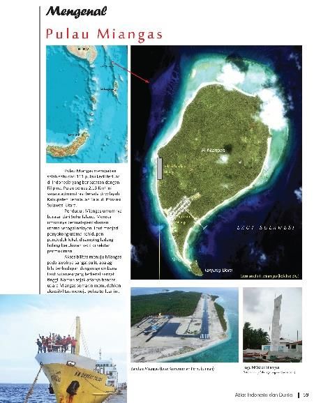
7 of 8
a small island called Miangas at coordinates 050 33 '55"N representatives of geography lecturers from universities,
and 126o 34o 58oE. The distance of this island is closer to team of Center for Development and Empowerment of
the General Santos City of the Philippines (89 nautical Educators and Education Personnel (P4TK), social
miles) compared to Manado City, the capital of North science technical team from Directorate of Middle School
Sulawesi Province which reaches 265 nautical miles. In Development, and mapping team from Geospatial
the context of the archipelagic state territory, the Information Agency. The content reviewed concerning as
existence of Miangas Island is very vital because it follows:
concerning state sovereignty. In this context, an example 1) Correction of the map data frame and the marginal
of literacy about the area delivered to students. information, including coloring aspects, text writing,
Text information in the form of narrative text is an terms, images, graphics, and other technical matters
important part of this atlas. Narrative text becomes the 2) Content material review, congeniality with the
source of information that explains a particular object. In curriculum and learning requirements of junior high
Figure 10, there is a narrative text about Miangas Island school social studies
which explains the strategic value information of the 3) Recommended improvements in either reduction or
island in the context of Indonesia as an archipelagic state. addition of atlas content.
In general, the percentage of text information is more in
historical atlas than in the territorial atlas. The percentage One important input obtained during the workshop
comparison of maps (spatial) and non-spatial information is that the level of readability of the map/atlas must be
of the territorial atlas is 90% and 10%, while in the clear, simple, unambiguous, and entirely practical
historical atlas ranges from 70% and 30%. considering the target of the atlas user is students who
All thematic maps and photo information, satellite have only reached the average age of 12-15 years, the
images, and arranged narratives text are compiled into an range of juvenile age.
atlas. The concept of the atlas is not a pile of meaningless
maps, but geospatial information that arranged in a
coherent and comprehensive manner. Therefore, the team 3.6. Atlas Distribution and Dissemination
arranged the contents according to the structure of the The Territorial and Historical Atlas for Junior High
atlas that agreed in the focus group discussions. Schools that have been successfully completed has been
socialized through various media. First, printed atlas
books and e-books were distributed to approximately
3.5. Atlas Readability Trial-Test 3,500 junior high schools in Indonesia through the
An important step in producing quality atlases is Indonesian Ministry of Education and Culture. Second,
arranging a trial-test workshop on the readability of the the dissemination through network/online media can be
atlas. Before the workshop is held, printing test is accessed from the website: https://atlas.big.go.id/eatlas1/.
important to do. This step is done to do the proofreading This media can be accessed for alternative and interactive
so that any errors in result printing could be known, for learning facilities for students.
example, an error in colors different from those on the
computer, the font that changed from the original, broken
images, and other important things. The printed atlas then
carried out by a review process in the atlas readability
trial-test workshop.
Figure 12. The mass production process of Indonesian
Figure 11. Atlas Readability Trial-Test Workshop Territorial and Historical Atlas
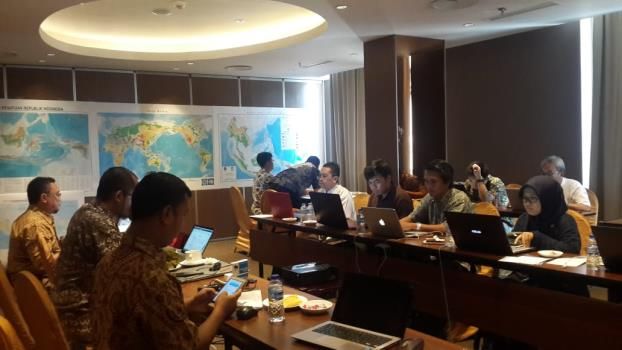
The atlas readability trial-test workshop involved Media of atlas that varies from hardcopy, softcopy
representatives of Junior High School social studies to an online electronic atlas that conducted in this activity
practitioners from various regions in Indonesia, considering that Indonesia is an archipelago. Some areas
Proceedings of the International Cartographic Association, 2, 2019.
29th International Cartographic Conference (ICC 2019), 15–20 July 2019, Tokyo, Japan. This contribution underwent
single-blind peer review based on submitted abstracts. https://doi.org/10.5194/ica-proc-2-90-2019 | © Authors 2019. CC BY 4.0 License.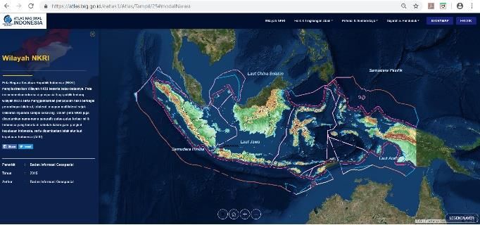
8 of 8

are familiar with the internet, on the other hand, most of           6. References
the others are still not accessible to the internet. Online          Bachtiar, T. (2018, November 30). Geoliterasi. Retreived
atlas can be accessible to those who have good internet               from https://www.pikiran-rakyat.com/kolom/2018/11/
connection access, for others who are not accessible to               30/ geoliterasi-433872 on March 15, 2019.
the internet, they are given a printed book atlas. Online
atlas and printed atlas books are part of learning geo-              International Cartographic Association. (1998). Atlas
literacy in the class.                                                Production for Southeast Asia: Vol 2 the Proceedings of
                                                                      International Wokshop/Seminar ‘Modern Cartography
                                                                      for Navigating the Information Highway’ held in
                                                                      Bandung, Indonesia March 3-14, 1997.
                                                                     The Ministry of Education and Culture of the Republic of
                                                                      Indonesia. (2014). Curriculum 2013 Implementation
                                                                      (Implementasi Kurikulum 2013). Press Workshop.
                                                                      Pondok Cabe, January 14, 2014.
                                                                     Koop, R.O. (1993). Tools for the Electronic Production
                                                                      of Atlases. pp 129-137 in: I. Klinghammer e.a. (eds).
                                                                      Proceeding of the Seminar on Electronic Atlases, held
Figure 13. Online atlas website
                                                                      in Visegrad, 1993. Budapest: Eotvos Lorand University.
                                                                     Kraak, M.J and Ormeling, F. (2003). Cartography:
                                                                      Visualization of Geospatial Data. Second Edition.
4. Conclusions and Recommendations                                    Pearson Education Limited.
     The Republic of Indonesia Territorial and Historical            Mustofa, F. (2016). Atlas, Front Gate of Geospatial
Atlas are structured comprehensively and interrelated                 Information (Atlas, Gerbang Depan Informasi
between regions, both nationally or internationally so that           Geospasial). GEOtangkas Magazine Vol. 1. No. 2 –
the element of connectivity between spaces is fulfilled               2016 [10-15]
according to the mandate of the National Education                   National Geographic. (2012). What is Geo-literacy?.
Curriculum in Indonesia. Media atlas in printed books, e-             Retreived from https://www.nationalgeographic.org/
books, and online atlas are estimated as an effective way             media/what-is-geo-literacy/ on March 21, 2019
of learning in the classroom and as a method in                      Ormeling, F. (2013). Thematic Cartography: Social and
supporting national literacy programs. In this case,                  Economic Aspect (Kartografi Tematik: Aspek Sosial
support for strengthening national literacy is in the form            dan Ekonomi). Penerbit Ombak, Yogyakarta.
of spatial aspect learning (geo-literation).
                                                                     Prahasta, E. (2005). Basic Concepts of Geographic
                                                                      Information Systems (Konsep-konsep Dasar Sistem
5. Acknowledgements                                                   Informasi Geografis). CV. Informatika, Bandung.
     The Geospatial Information Agency team would                    Prasetyaningrum, T. D., Rahardjo, N., and Rosyadi, R. I.
like to thank the Directorate of Junior High School                   (2017). Production of Web-based Museum Tourism
Development, the Directorate General of Primary and                   Atlas in Yogyakarta Special Region (Penyusunan Atlas
Secondary Education, the Ministry of Education and                    Wisata Museum Berbasis Web Daerah Istimewa
Culture of the Republic of Indonesia, which has                       Yogyakarta). Jurnal Bumi Indonesia Volume 6 No 1
collaborated both in developing the atlases and                       2017 [1-10].
disseminating these products to thousands of schools in              Setiawan, I., Dedi, S., and A. Mushlih. 2016. Social
Indonesia.                                                            Science for Junior High School (Ilmu Pengetahuan
                                                                      Sosial Untuk SMP/MTs). Jakarta: Kementerian
                                                                      Pendidikan dan Kebudayaan.
                                                                     Soendjojo, H. and Riqqi, A. (2012). Kartografi. Penerbit
                                                                      ITB, Bandung.

Proceedings of the International Cartographic Association, 2, 2019.
29th International Cartographic Conference (ICC 2019), 15–20 July 2019, Tokyo, Japan. This contribution underwent
single-blind peer review based on submitted abstracts. https://doi.org/10.5194/ica-proc-2-90-2019 | © Authors 2019. CC BY 4.0 License.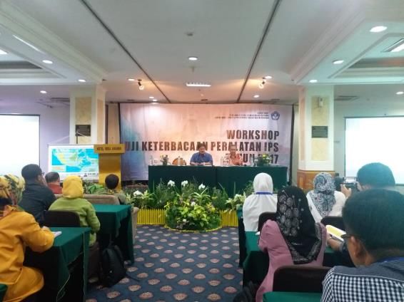
You can also read