The Roman Heritage of Medieval World Maps - Digital Kenyon
←
→
Page content transcription
If your browser does not render page correctly, please read the page content below
Peregrinations: Journal of Medieval Art and Architecture
Volume 6 | Issue 3                                                                                                                                      1-20

4-2018

The Roman Heritage of Medieval World Maps
Emily Albu
University of California, Davis

Follow this and additional works at: https://digital.kenyon.edu/perejournal
     Part of the Ancient, Medieval, Renaissance and Baroque Art and Architecture Commons

Recommended Citation
Albu, Emily. "The Roman Heritage of Medieval World Maps." Peregrinations: Journal of Medieval Art and Architecture 6, 3 (2018): 1-20.
https://digital.kenyon.edu/perejournal/vol6/iss3/1

This Feature Article is brought to you for free and open access by Digital Kenyon: Research, Scholarship, and Creative Exchange. It has been accepted
for inclusion in Peregrinations: Journal of Medieval Art and Architecture by an authorized editor of Digital Kenyon: Research, Scholarship, and
Creative Exchange. For more information, please contact noltj@kenyon.edu.
Albu

                  ____________________             PEREGRINATIONS____________________
                                       JOURNAL OF MEDIEVAL ART AND ARCHITECTURE
                                                     VOLUME VI, NUMBER 3 (SPRING 2018)

              The Roman Heritage of Medieval World Maps

              EMILY ALBU
              Professor of Classics, University of California, Davis

                   In a brief chapter of The Medieval Peutinger Map, I outlined the legacy that Rome

              bequeathed to medieval world mapping.1 There I discussed the prevailing Roman

              “itinerary mind,” with Roman armies, civil servants, and civilian travelers consulting

              itineraries rather than maps; and I considered the cosmic (or bird’s-eye) view presented

              by Roman intellectuals, a perspective that would have lasting influence. Recent

              “Mappings” sessions at Kalamazoo and Leeds have given me the welcome opportunity

              to reexamine those arguments and dig a little deeper.2 This closer look reveals how Greco-

              Roman ideas – from the conceptions of the land masses and surrounding ocean to the

              accumulated data of peoples and places – would have enabled the conceptualization of a

              world map, as we will see in the information preserved and widely transmitted in late

              antique works by Orosius (writing 417-418 C.E.) and Isidore of Seville (c. 560-636 C.E.).

              Romans repeatedly asserted that the display of such geographical knowledge affirmed

              1 Emily Albu, The Medieval Peutinger Map: Imperial Roman Revival in a German Empire (Cambridge:
              Cambridge University Press, 2014), 19-29. Patrick Gautier Dalché has written a foundational essay on this
              subject: “L’héritage antique de la cartographie médiévale: les problèmes et les acquis” in Cartography in
              Antiquity and the Middle Ages: Fresh Perspectives, New Methods, eds. Richard J. A. Talbert and Richard W.
              Unger (Leiden and Boston: Brill, 2008), 29-66.

              2Warm thanks to Dan Terkla and Felicitas Schmieder for organizing three sessions on medieval mapping
              and to all the participants, from whom I learned a great deal. I am also grateful for the astute suggestions
              of Asa Mittman and Dan Terkla, who read an earlier draft of this paper, with thanks to Sarah Blick for
              suggesting images.

                                                                                   1

Published by Digital Kenyon: Research, Scholarship, and Creative Exchange, 2018
Peregrinations: Journal of Medieval Art and Architecture, Vol. 6, Iss. 3 [2018]
dominion over the territories surveyed, a lingering belief that led to a medieval battle of
the maps between religious and secular authorities.
The Roman legacy is at once more intriguing and more profound than we might
expect, given the spare and contested evidence for the existence of Roman world maps.
No such maps survive, because the Romans, like the Greeks, did not really have a word
for “map”; furthermore, the identification and interpretation of the evidence present a
particular challenge. Not until a ninth-century catalogue of library holdings at Reichenau
do we find the name for a world map, mappamundi, while the Roman-era terms like
descriptio mundi (representation or description of the world) or itinerarium pictum (painted
itinerary) may refer to geographical narratives or illustrated lists of toponyms rather than
what we consider a map.3 Scholars have reached no consensus on this question.
Roman Precedents
As they found their way out into the world, Roman merchants, bureaucrats, and
military commanders on campaign recorded their journeys in lists and narratives, as the
surveyors of Alexander the Great (356-323 B.C.E.), Diognetus and Baito, and others had
done before them.4 These reports transmitted the one-dimensional “hodological” view
3 The Reichenau catalogue of 821-822 lists a mappa mundi in rotulis II (world map on two rolls), widely
assumed to be a pictorial image rather than a geographical text, though this is the earliest surviving use of
the term mappa mundi, and the artifact itself does not survive. Hans Lieb suggested that it was a forerunner
of the Peutinger map, separated into two parts when the adhesive between parchment pieces failed. Hans
Lieb, “Zur Herkunft der Tabula Peutingeriana” in Die Abtei Reichenau: Neue Beiträge zur Geschichte und
Kultur des Inselklosters, ed. Helmut Maurer (Sigmaringen: Thorbecke, 1974), 31-33. On the occurrences of
the term mappa (mundi): Patrick Gautier Dalché, “Les sens de mappa (mundi): IVe-XIVe siècle,” Archivum
Latinitatis Medii Aevi (Bulletin du Cange) 62 (2004): 187-202.
4 For more on Alexander’s distance-measurers: Germaine Aujac, J. B. Harley, and David Woodward, “The
Growth of an Empirical Cartography in Hellenistic Greece,” in The History of Cartography, vol. 1: Cartography
in Prehistoric, Ancient, and Medieval Europe and the Mediterranean, eds. J. B. Harley and David Woodward
(Chicago: University of Chicago Press, 1987), 149; and Waldemar Heckel, Who’s Who in the Age of Alexander
2
https://digital.kenyon.edu/perejournal/vol6/iss3/1Albu
that prevailed in antiquity, rather than the two-dimensional cartographic view in the
images that we call maps today.5 No incident better illustrates the Roman traveler’s
reliance on such itineraries than Julius Caesar’s mishap as he rode toward his momentous
Rubicon crossing.6 Traveling by carriage, he and his companions found themselves off-
road and wandered lost in the dark of night until, at daybreak, a guide took them back
to the route, leading them there on footpaths. Caesar’s commentaries never mention a
map, though he could surely have used one, perhaps especially then. Serious difficulties
could arise when Roman armies lacked the maps and detailed reconnaissance upon
which modern strategists rely. Yet, as A. C. Bertrand has reminded us, Caesar and other
Roman military commanders achieved breathtaking success, using rivers, local trails, and
other landmarks to construct “mental maps” to help them envision their way until
Roman roads made the territory more easily imaginable. 7 The absence of a physical map
ultimately proved no insurmountable obstacle to empire.
Although we have no evidence for maps that guided legionary commanders or other
Romans on the move, we have ample testimony for the Romans’ impressive ability to
survey smaller parcels with the centuriation of rural plots in newly conquered lands and
the Great: Prosopography of Alexander’s Empire (Chichester, West Sussex, UK: Wiley-Blackwell, 2009), 67 and
113.
5 The hodological view shows pathways. The illustrated route maps of Matthew Paris offer a medieval
example, while AAA TripTik Travel Planners present hodological aids to twenty-first-century travelers
nostalgic for old-time navigational tools.
6For the arguments against the use of military maps, see A. C. Bertrand, “Stumbling through Gaul: Maps,
Intelligence, and Caesar’s Bellum Gallicum,” The Ancient History Bulletin 11.4 (1997), 107-122; and C. R.
Whittaker, “Mental Maps and Frontiers: Seeing Like a Roman” in Rome and its Frontiers: The Dynamics of
Empire (Oxford: Routledge, 2004): 63-87.
7Bertrand, “Stumbling through Gall.” Bertrand (p. 118) quotes this classic explanation of mental mapping
as “simply the process by which all humans organize and make sense of the environment around them.
Cognitive, or mental, maps arise from the storage and memory of spatial information that is necessary to
survive. They reflect the world as perceived, not necessarily as it is.” M. E. Downs, “Spatial Conception in
the Ancient Geographers and the Mapping of Hispania Baetica,” Classical Bulletin 72 (1996): 37-49, at p. 43.
For the Romans, that entailed thinking in terms of lines or route networks – or itineraries.
3
Published by Digital Kenyon: Research, Scholarship, and Creative Exchange, 2018Peregrinations: Journal of Medieval Art and Architecture, Vol. 6, Iss. 3 [2018]
with the drawing of urban property lines by agrimensores, even precisely measuring and
carving a detailed display of their principal city, the famous Marble Plan, the Forma Urbis
Figure 1 Fragments of the Forma Urbis Romae in an engraving by Giovanni Battista
Piranesi, 1756. Photo: Wikipedia, Le antichità Romane, t. I, tav. IV, Opere di Giovanni
Battista Piranesi (Paris: Firmin Didot Freres, Paris, 1835-1839), vol. I.
4
https://digital.kenyon.edu/perejournal/vol6/iss3/1Albu
Romae.8 (Fig. 1) An instrument called the groma enabled the surveying of “straight lines,
squares, and rectangles.”9 (Fig. 2) These and related skills of measurement and
engineering addressed pragmatic concerns of forging and maintaining their empire –
distributing land, building roads, moving armies, and managing the food and water
supplies that supported vast populations and sustained their imperial enterprise.
Figure 2 Using a groma. Image: after
http://legioneromana.altervista.org/content/how-use-roman-groma?language=en
For the larger space that enclosed that enterprise, and for the even grander space of
the Roman imperial imagination, Romans constructed their own distinctive mental maps
8O. A.W. Dilke, “Roman Large-Scale Mapping in the Early Empire,” in Harley and Woodward, History of
Cartography, vol. 1, 212-232; and Anne Kolb, “Die Erfassung und Vermessung der Welt bei den Römern” in
Vermessung der Oikumene, eds. Klaus Geus and Michael Rathmann, Topoi. Berlin Studies of the Ancient
World, 14 (Berlin and Boston: De Gruyter, 2013): 107-118. For details on the Forma and its restoration, see
http://formaurbis.stanford.edu/does/FURmap.html.
9 Dilke, “Roman Large-Scale Mapping,” 214. See pp. 213-214 for more on the groma.
5
Published by Digital Kenyon: Research, Scholarship, and Creative Exchange, 2018Peregrinations: Journal of Medieval Art and Architecture, Vol. 6, Iss. 3 [2018]
of the world. Here, as in so many arenas, they had Greek forerunners. From the sixth
century B.C.E. onward, Greek science had designed the theoretical tools and
measurements for creating globes as well as two-dimensional depictions of the oikoumene,
the inhabited part of the earth.10 None of these artifacts survive, and the best descriptions
of Greek world maps come from Diogenes Laertius, writing eight centuries later. Further
evidence of world mapping skills comes from Herodotus, the fifth-century B.C.E.
historian, who critiqued flat-surface depictions of Europe, Asia, and Africa surrounded
by ocean, while his younger contemporary, the Athenian playwright Aristophanes,
presented a witty commentary on a world map in The Clouds.11 Literary sources
demonstrate that Roman intellectuals, too, could imagine a bird’s-eye view of their
world.12 We owe to Cicero the most enduring Roman imagining of this vision of the earth.
In the Somnium Scipionis that closed his De re publica, he evoked the old contemplative
tradition of the soul’s ascent to heaven. There he presented Scipio Aemilianus, the
venerable Roman victor over Carthage, dreaming that he was looking down from the
stars and observing from his celestial perspective the tiny extent of Roman imperium.
The literary and philosophical imagination enabled this concept of world mapping. But
did the Romans actually draw such maps?
Advocates of Roman world mapping invoke “Agrippa’s map” as an early imperial
example. It seems impossible, though, to pin down exactly what this was. When Pliny
10Kai Brodersen, Terra Cognita: Studien zur römischen Raumerfassung (Hildesheim: Georg Olms, 1995; 2nd
ed. 2003). For a synopsis of Brodersen’s theory, see Emily Albu, “Rethinking the Peutinger Map,” in
Cartography in Antiquity and the Middle Ages: Fresh Perspectives, New Methods, 112.
11Herodotus, History. The Persian Wars, tr. George Rawlinson (New York: Modern Library, 1942), 4.36-45;
and Aristophanes, The Clouds, lines 200-217, in Fabulae I, ed. Nigel Guy Wilson (Oxford: Clarendon Press,
2007). Aristophanes presents a student in Socrates’ Thinkery showing off surveying instruments used to
measure the whole earth and a map (periodos) of the entire earth, though only Greek sites are specifically
pointed to here.
12 For examples, see Albu, Medieval Peutinger Map, 24-29.
6
https://digital.kenyon.edu/perejournal/vol6/iss3/1Albu
the Elder mentions its site in Rome, he presents the porticus Octaviae in the context of
Agrippa’s world survey and the distances that he had measured. 13 Kai Brodersen has
persuasively argued that Agrippa’s “map” was really just as Pliny suggested: a listing
and measurement of places in relation to one another, throughout the inhabited world. 14
The first Roman world map for which we have persuasive attestation as something we
would call a map is the one described by Eumenius in Augustodunum (modern Autun)
in the late 290s C.E. As we shall see, its dating and the function it shares with Agrippa’s
map prove telling.
Knowledge of the Land Conveys Authority
Romans had long cherished the idea that knowledge of the orbis terrarum conveyed
power over the earth and its peoples. When Cicero celebrated Caesar’s inroads into Gaul,
in his speech De Provinciis before the senate (56 B.C.E.), he insisted that Caesar’s
reconnaissance of previously unexamined lands enabled ownership of those lands and
their peoples. For Cicero, as for Romans before and after him, this concept led inexorably
to the assertion (despite ample evidence to the contrary) that the Roman empire and the
inhabited world were coterminous: “Now at length we have reached the consummation
that the limits of our Empire and those of the inhabited world are one and the same.” 15
For Cicero, the philosopher who produced the Somnium Scipionis, the Roman
imperium might be a tiny bit of the universe, with its political and civil troubles mere
Pliny the Elder, Natural History 3:16-17. C. Plini Secundi Naturalis Historiae Libri XXXVII, ed. Carolus
13
Mayhoff (Stuttgart: Teubner, 1967-70).
Kai Brodersen, Terra Cognita, 268-287; see also Trevor Murphy, Pliny the Elder’s Natural History: The
14
Empire in the Encyclopedia (Oxford: Oxford University Press, 2004), 157, note 57.
15Nunc denique est perfectum, ut imperii nostri terrarum que illarum idem esset extremum (Prov. cons. 33);
Bertrand, “Stumbling through Gaul,” 117; Christopher B. Krebs has advanced the argument that, for
Romans, a display of the world conveyed pretensions of ownership: “‘Imaginary Geography’ in Caesar’s
‘Bellum Gallicum,’” The American Journal of Philology 127.1 (Spring 2006): 111-136, at p. 117.
7
Published by Digital Kenyon: Research, Scholarship, and Creative Exchange, 2018Peregrinations: Journal of Medieval Art and Architecture, Vol. 6, Iss. 3 [2018]
cosmic trifles. But for Cicero, the consummate Roman politician and senator, Rome was
the world. Domination of the oikoumeme/orbis terrarum was Rome’s destiny, as Polybius,
the Greek historian of Rome’s early conquests, had explained more than one hundred
years earlier. By Cicero’s day, in the final gasps of the Roman republic evolving into
empire, his contemporaries believed this ambition was well on its way to fruition.
Cicero’s contemporary, the poet Catullus, could imagine Romans making exotic
journeys to the peoples at the far frontiers of the known world. In audacious verses, he
mocked two characters who professed their willingness to accompany him and confront
any strange and distant peoples, eager to travel to the Indians, Hyrcanians and Arabs, to
the Sagae, Parthians, and Egyptians – to the East, where the exploits of Crassus were
promising great wealth – or across the Alps with “great Caesar,” to the Gauls and farthest
Britons.16 The poet threatens to test his comrades’ bravery by sending them on a
dangerous embassy with a crude message to his former lover. Ultimately, then, the
imagined journey across the known world, from India to Britain, is only leading the way
to a bitter joke. It is Catullus’s bravura verbal display of the oikoumene, however, that
dominates the poem. Such a description by a private citizen provocatively tested the
bounds of permissible discourse in the volatile Roman republic. Catullus was a bold
young man who dared to write a witty mockery of Julius Caesar’s intimates and of Caesar
himself.17 Yet his poetic depiction of that contested world was equally daring. Under
Roman emperors to come, the visual representation of the orbis terrarium would become
the prerogative of the emperor himself. Near the end of the first century, the emperor
Domitian is alleged to have ordered the execution of Mettius Pompusianus, who was
accused of committing what Pascal Arnaud has called the “cartographic crime” of
16 Catullus, Carmina, ed. D. F. S. Thomson (Toronto: University of Toronto Press, 1997), Carmen 11.
17 Catullus 29 and 57.
8
https://digital.kenyon.edu/perejournal/vol6/iss3/1Albu
painting a depiction of the world on his bedroom wall.18 Any display of the earth carried
weighty, potentially dangerous, imperial implications.
Catullus tested the boundaries of allowable geo-sarcasm in his audacious verses from
the late republic, and an early imperial official and natural scientist revealed how a more
extended view of the world could serve imperial interests. Pliny the Elder (23 or 24–79
C.E.) was a wealthy Roman military officer and civil servant whose duties took him to
much of the western Roman world – to Germany, Spain, Africa, and probably to Gaul.
Counselor to the emperors Vespasian and Titus, and a man of enormous discipline and
energy, he managed also to write many books on a variety of subjects. Of these, only his
Natural History survives. This large, comprehensive encyclopedia surveys the cosmos and
geography of the world before going on to describe humans and other animals, insects,
plants, medicines, and minerals. Four of the thirty-seven books in the Natural History take
the reader on a journey around the orbis terrarum. Trevor Murphy has demonstrated the
Roman imperial connections of a text that views its world from the proud perspective of
a central imperial authority.19 Only the expansion of that authority, as Pliny saw it, made
possible the scale of his massive collection. That is, Rome’s imperial enterprise enabled
the collecting and comprehension of all the aggregated knowledge in Pliny’s book.
Pliny’s encyclopedic work served as more than a preserver of ancient geographical
knowledge. It transmitted a view of geography as imperial domain and exercised a
considerable influence on medieval mapping. But his was a world poised on the brink of
revolutionary change. While governor of Bithyinia-Pontus, his nephew Pliny the
Younger (Gaius Plinius Caecilius Secundus, c. 61-c. 112 C.E.), corresponded with the
emperor Trajan about the vexing new problem of Christians challenging ancestral Roman
18Pascal Arnaud, “L’affaire Mettius Pompusianus, ou le crime de cartographie,” Mélanges de l’École française
de Rome: Antiquité 95 (1983): 677-699.
19Trevor Murphy, Pliny the Elder’s Natural History: The Empire in the Encyclopedia (Oxford: Oxford
University Press, 2004).
9
Published by Digital Kenyon: Research, Scholarship, and Creative Exchange, 2018Peregrinations: Journal of Medieval Art and Architecture, Vol. 6, Iss. 3 [2018]
rituals and the imperial cult. The resulting seismic conflict found apparent resolution in
the strategic conversion of Constantine (senior emperor, 312-337 C.E.) and the authority
of his successors, who established Christianity as the state-sanctioned religion.
Figure 3 Beatus Map from the Saint-Sever Beatus, produced in Saint-Sever Abbey, France, c.
1050. Photo: Wikipedia https://en.wikipedia.org/wiki/Beatus_map
The adoption of Christianity as Rome’s solely authorized religious authority led to a
new kind of enduring conflict. As Christians rethought world history, imagining it from
the moment of God’s creation to their own time and place, so they claimed the inhabited
world for Christendom. They embraced the Hebrew Bible, putting special emphasis on
the passage in Genesis 1:26-28 urging humankind to subdue the earth and giving humans
domination over all the other creatures of land, air, and waters. This complemented the
New Testament charge to the apostles, who were sent out to spread God’s word to all the
lands, as famously announced, for instance, on the Beatus world maps (10th-13th
10
https://digital.kenyon.edu/perejournal/vol6/iss3/1Albu
centuries).20 (Fig. 3) Christian world maps, like those presented in the Beatus manuscripts
or displayed in papal and episcopal palaces, were far from benign decorations. They
made aggressive claims to the earth.
Narrative Traditions
By justifying secular geographical studies and incorporating that knowledge into their
own works, Christian writers, notably Augustine and Cassiodorus, ensured the
preservation of ancient learning drawn, for example, from Pliny’s Natural History,
Pomponius Mela’s Chorography, Julius Solinus’s Collection of Remarkable Things, and from
late antique writers who transmitted their Greco-Roman legacy.21 As Natalia Lozovsky
has noted, “This legacy included both theoretical questions (such as the spherical form of
the earth, its size, its division into three continents) and detailed descriptions of
regions.”22 Endorsed by Christian authorities as an essential foundation for
understanding the Bible, cartographical knowledge of God’s creation entered the schools’
and university curricula. This pedagogy argued for Christianity’s central place in God’s
plan, demonstrated the global impact of the new religion, and bolstered Christianity’s
claims of worldwide dominion.
The most influential late antique writers in the genre of Christian geography are
Orosius and Isidore of Seville. Probably born in Roman Gallaecia (northern Portugal
20 Ingrid Baumgärtner, “Die Welt im kartographischen Blick: Zur Veränderbarkeit mittelalterlicher
Weltkarten am Beispiel der Beatustradition vom 10. bis 13. Jahrhundert,” in Der weite Blick des Historikers:
Einsichten in Kultur-, Landes- und Stadtgeschichte. Peter Johanek zum 65. Geburtstag, eds. Wilfried Ehbrecht,
Angelika Lampen, Franz-Joseph Post, and Mechthild Siekmann (Cologne, Weimar, and Vienna: Böhlau
Verlag, 2002), 527-549.
21Pomponius Mela, De situ orbis, ed. C. Frick (Leipzig, 1880); Frank E. Romer, Pomponius Mela’s Description
of the World (Ann Arbor: University of Michigan Press, 1998). Solinus, Collectanea rerum memorabilium, ed.
Theodor Mommsen (Berlin, 2nd edition 1895).
Natalia Lozovsky, The Earth is Our Book: Geographical Knowledge in the Latin West ca. 400-1000 (Ann Arbor:
22
University of Michigan Press, 2000), 7. This book is an invaluable source.
11
Published by Digital Kenyon: Research, Scholarship, and Creative Exchange, 2018Peregrinations: Journal of Medieval Art and Architecture, Vol. 6, Iss. 3 [2018]
today), Paulus Orosius (fl. early fifth century) traveled to Hippo Regius to study with
Augustine and to Jerusalem for a church council. His Seven Books of History against the
Pagans served as a companion piece to Augustine’s City of God, which was written to
show—despite the contrary evidence from the events of 410—that the world had
improved and human miseries decreased, since the rise of Christianity. 23 Orosius’s
demonstration opens with a geographical turn around the world, beginning with an
introduction to the earth’s three partes (Africa, Asia, and Europe) and their provinces and
identifying prominent cities, rivers, and mountains.24 Following the pattern of late
antique and Carolingian narratives, Orosius for the most part repeated geographical
knowledge gained from classical sources, retaining for instance the ancient names for
sites.25 This habit lends the narrative a timeless air, while serving the practical purpose of
helping readers of both classical texts and scripture locate places and peoples on the
world stage. Orosius’s rather detailed world tour introduces a sequential history of world
empires leading providentially to Christian Rome and the pax Romana that enabled the
successful spread of the new faith. This was a critical part of Orosius’s counter-argument
to the troubling evidence that “pagans” had been correct in insisting that the exclusive
adoption of Christianity would cause the collapse of a Roman empire sustained through
23 Orose. Histoires, 3 vols., Collection des Universités de France, ed. M.-P. Arnaud-Lindet (Paris: Les Belles
Lettres, 1990-1991); and Orosius, Seven Books of History against the Pagans, Translated Texts for Historians,
tr. A. T. Fear (Liverpool: Liverpool University Press, 2010). Evelyn Edson, Mapping Time and Space: How
Medieval Mapmakers Viewed their World (London: The British Library, 1997), 31. On Orosius’s universalism,
see Andrew Merrills, History and Geography in Late Antiquity (Cambridge: Cambridge University Press,
2005); and Peter Van Nuffelen, Orosius and the Rhetoric of History (Oxford: Oxford University Press, 2012).
For a discussion of the partes of the earth, see Christoph Mauntel’s “Fra Mauro's View on the Boring
24
Question of Continents,” in this volume.
25Lozovsky, The Earth Is Our Book, 71; on the Carolingian habit of maintaining the classical image of the
world, with rare updating or reliance on autopsy, see 136-52. In this, later writers were only following the
practice of Roman elites, who privileged literary tradition. Susan Mattern has mustered the evidence for
this Roman habit in their creation of mental maps: Rome and the Enemy: Imperial Strategy in the Principate
(Berkeley and Los Angeles: University of California Press, 1999), esp. pp. 24-66. “In general,” she wrote (p.
33), “I would argue that we do not see a sharp distinction in the Roman mind between rhetoric and ‘fact.’”
12
https://digital.kenyon.edu/perejournal/vol6/iss3/1Albu
the centuries by devotion and sacrifice to the imperial cult and the ancient Greco-Roman
gods. So revered was Orosius’s geographical chapter that scribes also copied it on its own,
disseminating it under the title Description of the Earth or The Account of the Whole Earth, or
Provinces. Like the works of Pliny, Mela, and Solinus, Orosius’s Seven Books of History
against the Pagans “became a school text and an authority for later geographical
writings.”26
Isidore of Seville (c. 560-636), bishop and scholar, was a prolific writer, best known for
his encyclopedic Etymologies, material gathered from a broad array of Greco-Roman
sources, polytheistic and Christian, organized within a Christian framework. Invoking
the masterful medievalist Ernst Robert Curtius, John Henderson has concluded: “As
Curtius plainly saw…, etymology is harnessed to grander, higher, purpose as Isidore
construes the grammar of the universe.”27 Here is ancient geographical knowledge culled
from a variety of sources, especially as collected by Varro (116-27 B.C.E.), a prolific scholar
whose works are now largely lost, and by Pliny the Elder.28 While punctuating his text
with sarcastic assaults on polytheism and the “fake knowledge” of the ancient world,
Isidore preserved a vast array of Greco-Roman learning. Despite its formidable length,
his Etymologies survives in nearly one thousand manuscript copies.29
26Lozovsky, The Earth Is Our Book, 77-78; for the Isidorean tradition in late antique and early medieval
schools, with its foundation in etymologies, see pp. 103-113.
27John Henderson, The Medieval World of Isidore of Seville: Truth from Words (Cambridge: Cambridge
University Press, 2007), 24. See Ernst Robert Curtius, Europäische Literatur und lateinisches Mittelalter (Bern:
A. Francke AG Verlag, 1948), tr. Willard R. Trask, European Literature and the Latin Middle Ages (New York:
Harper & Row, 1953), esp. Excursus XIV, “Etymology as a Category of Thought,” 495-500.
28 Of Varro’s seventy-some known works, only his Res Rustica survives intact.
29 The Etymologies of Isidore of Seville, tr. Stephen A. Barney, W. J. Lewis, J. A. Beach, Oliver Berghof
(Cambridge: Cambridge University Press, 2006), 24. On the influence of the Etymologies, see pp. 24-26; for
a list of modern editions and translations: p. 29.
13
Published by Digital Kenyon: Research, Scholarship, and Creative Exchange, 2018Peregrinations: Journal of Medieval Art and Architecture, Vol. 6, Iss. 3 [2018]
Repeated surveys of the world offer Isidore’s attentive reader a detailed knowledge of
his world as known to Greeks and Romans. Book nine travels through the peoples of their
world, surveying their linguistic diversity in a babble / Babel of seventy-three languages.
Book thirteen features the earth’s waters, beginning with the surrounding ocean,
identifying the seas from north to south, with the Mediterranean naturally in the center,
and then the great gulfs: the Ionian, Caspian, Indian, Persian, and Arabian or Red seas.
There follow tides and straits, lakes and pools, hidden waters and springs, then more
than thirty of the earth’s great rivers, beginning with the four rivers flowing out of
Paradise – the Geon (which the Egyptians call the Nile), the Ganges (also called Phison),
the Tigris and Euphrates, – eastward to the Indus and Arar and westward to Italy’s Po
and Tiber, and on to the Danube, Rhone, and Rhine. Often Isidore identifies a river’s
source or tributaries and describes its course to its destination. By this point, the reader
has enough information to create a simple mappamundi.
Yet book fourteen repeats the tour again, from Paradise in Asia through Mesopotamia
and Arabia, across the lands to Africa, the old Roman provinces and Germany, this time
by land, with a detailed siting of islands, promontories, mountains and other physical
features, often with distance markers that would enable more precise mapping. Book
fifteen, for one last time, retraces the path from India, here identifying famous cities from
antiquity and scripture, with their origin stories, leading to Julius Caesar’s founding of
Isidore’s own Seville. “With the roll-call of urbanization,” writes Henderson, “Isidore is
still filling in the landscape of Planet Earth. Natural terrain had acquired borders and
regional divisions, cultural limits and areas. Now terrestrial space becomes place, as
humans nest in numbers . . . the building of cities now proves to organize society as
physical habitat.”30 In sum, Isidore has supplied the major features for a rather
sophisticated map of the known world.
30 Henderson, The Medieval World of Isidore of Seville, 175.
14
https://digital.kenyon.edu/perejournal/vol6/iss3/1Albu
Relevant sections of Orosius’s Histories and Isidore’s Etymologies found their way into
Bede’s Ecclesiastical History, into exegetical works, and Carolingian geographical manuals
like the ninth-century De situ orbis.31 In his De rerum naturis, another Carolingian writer,
Hrabanus Maurus, mined Isidore’s geographical books to write a detailed description of
the earth’s “seas, rivers, and regions.”32 Medieval mapmakers, for their part, owed a great
deal to Orosius’s Histories, as the Hereford map (c. 1300) advertises with a prominent
inscription “acknowledg[ing] Orosius . . . as its essential textual source: ‘Orosius’s
account, De Ornesta Mundi, as is shown within.’ ”33
Narrative traditions thus transmitted Rome’s geographical legacy, providing much of
the information that enabled medieval world mapping. The narrative strands are
intertwined – the secular Roman imperial (as with Pliny the Elder) and the works in
service to Christianity (as with Isidore and most obviously Orosius) are all intimately tied
to the power embedded in world mapping as an imperial enterprise concerned with these
questions: Who owns the world? Who has authority over its peoples and natural
resources? For emperors and secular officials, the answer was clear. Christians, however,
vigorously contested that view.
Battle of the Maps
31Patrick Gautier Dalché, “Maps in Words: The Descriptive Logic of Medieval Geography, from the Eighth
to the Twelfth Century” in The Hereford World Map: Medieval World Maps and their Context, ed. P. D. A.
Harvey (London: The British Library, 2006), 223-242, at p. 225.
32Lozovsky, The Earth Is Our Book, 22. On the reception of Roman imperial ideology in Carolingian
geographical texts, see Natalia Lozovsky, “Roman Geography and Ethnography in the Carolingian
Empire,” Speculum 81 (2006): 325-364, esp. 362-363.
33Diarmuid Scully, “Augustus, Rome, Britain and Ireland on the Hereford mappa mundi: Imperium and
Salvation, Peregrinations: Journal of Medieval Art and Architecture 4.1 (2013): 107-133, at p. 109.
http://digital.kenyon.edu/perejournal/vol4/iss1/6. For the Latin Descriptio Orosii de ornesta mundi sicut
interius ostenditur, Scully follows the translation of Scott D. Westrem, The Hereford Map: A Transcription and
Translation of the Legends with Commentary (Turnhout: Brepols, 2001), 6-7.
15
Published by Digital Kenyon: Research, Scholarship, and Creative Exchange, 2018Peregrinations: Journal of Medieval Art and Architecture, Vol. 6, Iss. 3 [2018]
From our standpoint in the twenty-first century, we see one side of that contest, in the
one thousand or so Christian mappaemundi that survive. Yet we also have abundant
evidence for a long line of imperial maps produced in support of secular authorities.
Perhaps it is no coincidence that the earliest of these to be securely identified as a world
map in support of a secular authority is the one described and interpreted by Eumenius
in his oration at the school in Augustodunum (modern Autun) in the late 290s. Consider
the timing of that map’s creation: the restoration of the school was possible because of
the restoration of Roman order at the close of the devastating third century, with its
domestic troubles and threats of invasion.
Eumenius was speaking at a ceremony observing the re-establishment of the school
but also, of course, celebrating the renewal of the empire. It may seem natural to us that
a world map would be publicly displayed to celebrate just that. In Eumenius’s words:
“Let the young people see and contemplate daily every land and all the seas and
whatever cities, people, nations that the unconquered rulers either restore by affection,
conquer by valor or restrain by fear.” The imperial message here is clear, and in
Eumenius’ conclusion: “For now, now at last it is a delight to see a picture of the world,
since we see nothing in it that is not ours.”34 The long-lived Roman sentiment echoes
Cicero’s some 350 years earlier; but now Eumenius can demonstrate this with “a picture
of the world.”
It seems no coincidence that Roman authorities produced this map as Christianity was
making inroads into the Roman consciousness and terrain, contesting secular jurisdiction
over the earth. Eumenius did not mention the Christians in his oration, likely because
34Nunc enim, nunc demum iuuat orbem spectare depictum, cum in illo nihil uidemus alienum. Eumenius, Oratio
pro instaurandis scholis, 9(4), in XII Panegyrici Latini, ed. Roger A. B. Mynors (Oxford: Clarendon Press, 1964),
20.2-21.3, tr. C. Edward V. Nixon and Barbara S. Rodgers, In Praise of Later Roman Emperors: The Panegyrici
Latini (Berkeley: University of California Press, 1994, 176-177. Citing this statement in the panegyric of
Eumenius, Diarmuid Scully wrote: “To map the world is to dominate it.” Scully, “Augustus, Rome, Britain
and Ireland on the Hereford mappa mundi,” 117.
16
https://digital.kenyon.edu/perejournal/vol6/iss3/1Albu
they were the thorn in the side of his emperor, Diocletian. Within a couple of decades,
another emperor, Constantine, would accept Christianity, and the religious landscape
would take a dramatic turn. After Constantine, Christian emperors in the West often
found themselves at odds with the papacy, with each claiming supreme authority over
God’s creation and the secular/Christian alliance sometimes breaking down in violence.
More frequent, though, were the competing displays of symbolic authority, like the orb
held by a king, emperor, or pope, or the world maps that secular and religious authorities
displayed in their battles for supremacy.35
Secular Maps
Roman emperors in the Christian East found ways to exercise control over the Church
and its patriarchs, often enjoying a more secure claim to be Christ’s regents on earth. The
competition in the more contested West, on the other hand, produced a tradition of now-
lost world maps once displayed in imperial and royal palaces. Let us briefly consider two
examples that illustrate the significance of this phenomenon. The world maps of
Charlemagne and those of Roger II, Norman king of Sicily, offer particularly tantalizing
case studies, especially given the weighty circumstances of their destruction, described
below.
Charlemagne must have seen the world map produced for Pope Zacharias (741-752)
and displayed in the dining room of his Lateran Palace in Rome to proclaim papal
assertions to universal power, as well as the even more provocative geographic narratives
that his own contemporary, Pope Leo II (795-816), installed in his Lateran banquet halls.
In Charlemagne’s palace at Aachen, the emperor exhibited four grand maps of his own,
three of silver and one of gold. Charlemagne’s biographer Einhard reports that two of the
silver maps depicted Rome and Constantinople. The third, “which far surpasses the
35 On these symbols and the battle of the maps, see Albu, Medieval Peutinger Map, 31-58.
17
Published by Digital Kenyon: Research, Scholarship, and Creative Exchange, 2018Peregrinations: Journal of Medieval Art and Architecture, Vol. 6, Iss. 3 [2018]
others both in the beauty of its workmanship and in its heavy weight,” Einhard wrote,
was “a map of the entire world, fashioned from three concentric circles and completed in
exquisite detail.”36 The future of that grand map revealed the profound significance it
held for its possessor. Though Charlemagne willed these maps to the support of the poor,
his son Louis the Pious paid to keep the world map alone of all his father’s treasures. In
the next generation, when Louis’s son, Lothar, found himself threatened by civil discord,
he broke up his grandfather’s world map and distributed the pieces to German magnates
as a sign of his willingness to share the realm with them. His act of desperation failed.
The empire dissolved, and the map’s pieces went missing.
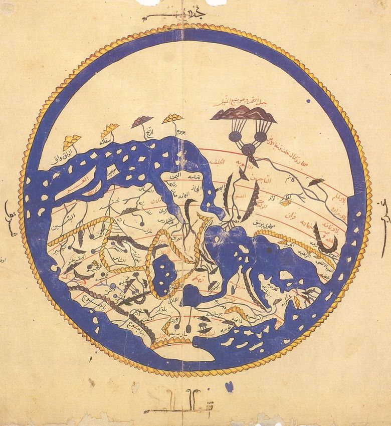
The fate of Roger’s map likewise reveals the symbolic power of a world map. (Fig. 4)
In 1154, the Arab geographer, Muhammad al-Idrisi, made a great silver map of the world
for Roger to display. This masterwork was a spectacular wonder, but an angry mob
destroyed it when they sacked the royal palaces in 1161, imprisoning Roger and his son,
William I, and assassinating his chief minister. This episode is usually seen as a rebellion
against the kings’ multiculturalism, his support of Muslims and Jews, with the map
broken up to confiscate the precious silver. But the map’s destruction may also have
represented a violent reaction against the imperial ambitions that Roger’s map signified.
A much more modest version, a manuscript illumination in a work commonly called the
Kitab Rujar (Book of Roger), al-Idrisi’s geographic description of the world, survived to be
frequently reproduced. Ten manuscript copies still exist, including eight with maps.
The Peutinger Map is the sole large-display piece surviving from that line of secular
world maps. It is traditionally considered a copy of a Roman map. Richard Talbert has
even imagined that its prototype was displayed in the apse of Diocletian’s palace aula in
36Einhard, Vita Karoli Magni, ed. and tr. Evelyn Scherabon Firchow and Edwin H. Zeydel (Coral Gables:
University of Florida Press, 1972), chap. 33. The fourth object Einhard described only as “made of gold and
extraordinarily large and heavy.”
18
https://digital.kenyon.edu/perejournal/vol6/iss3/1Albu
Figure 4 A Version of al-Idrisi’s World Map, 1456. Photo: Wikimedia
https://commons.wikimedia.org/wiki/File:Al-Idrisi%27s_world_map.JPG
19
Published by Digital Kenyon: Research, Scholarship, and Creative Exchange, 2018Peregrinations: Journal of Medieval Art and Architecture, Vol. 6, Iss. 3 [2018]
Split, making it almost contemporary with the world map described by Eumenius. 37
Although we have no evidence for such a map in Diocletian’s palace, this is an appealing
theory and is in line with the evidence for imperial display maps of the world. The extant
medieval map, made in Swabia around 1220, was, I have argued, intended to support the
imperial claims of the emperor Frederick II.38 Grandson of Roger II and raised in Sicily,
he would have had first-hand understanding of the authority and power a world map
held. Frederick and his Hohenstaufen kin engaged in a long-standing competition with
the papacy, with symbols of Roman imperium wielded as weapons. These included
“ceremony, liturgy, architecture, frescoes, mosaics, statuary, and papal thrones”– and
world maps.39
Conclusion
Medieval popes, kings, and emperors inherited the Roman concept that knowledge of
the land conveyed dominion over it. To display a world map was to demonstrate
authority over the earth. As we have seen, Greco-Roman geographical information
transmitted in late antique and Carolingian texts supplied sufficient data to enable the
creation of medieval world maps. And yet, arguably the most powerful legacy of Rome
for medieval world mapping is the impression of domination and ownership that world
maps convey.
37Richard J. A. Talbert, Rome’s World: The Peutinger Map Reconsidered (Cambridge: Cambridge University
Press, 2010), 442-457.
38 Albu, Medieval Peutinger Map, 85-117.
39 Mary Stroll, Symbols as Power: The Papacy following the Investiture Contest (Leiden: E. J. Brill, 1991), xv.
20
https://digital.kenyon.edu/perejournal/vol6/iss3/1You can also read