The Royal Arsenal Co-operative Society's Chalk Mine and the Building of the Bostall Estate
←
→
Page content transcription
If your browser does not render page correctly, please read the page content below
No. 006

The Royal Arsenal Co-operative Society’s
Chalk Mine and the Building of the Bostall
                 Estate

                            R. F. LeGear

   This paper has been downloaded from www.kentarchaeology.ac. The
    author has placed the paper on the site for download for personal or
 academic use. Any other use must be cleared with the author of the paper
                        who retains the copyright.

  Please email admin@kentarchaeology.ac for details regarding copyright
                             clearance.

The Kent Archaeological Society (Registered Charity 223382) welcomes the
 submission of papers. The necessary form can be downloaded from the
                  website at www.kentarchaeology.ac

                                                                            1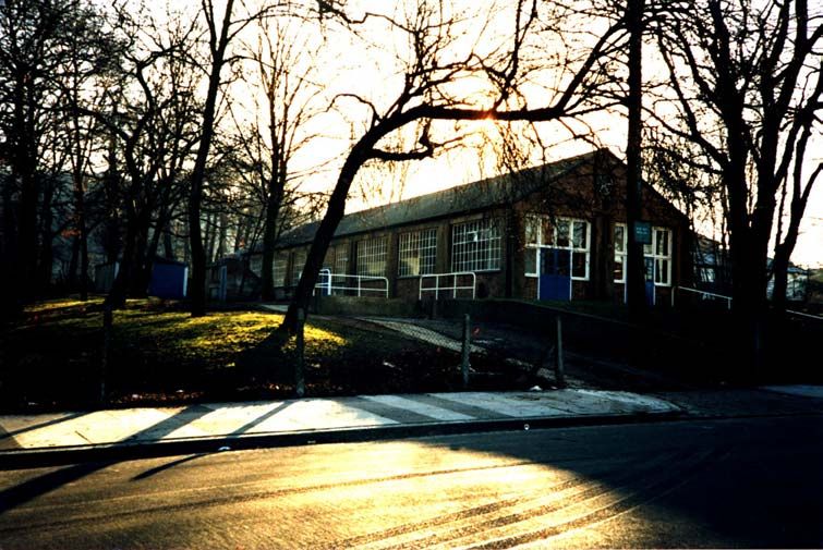
Introduction

        In 1899 the Royal Arsenal Co-operative Society embarked on a massive
building project, a venture very different from its retail activities. A small town or
settlement was to be built suitable for ‘the industrial classes’. The Bostall Estate in
south-east London was constructed by the R.A.C.S. works department, which moved
in its entirety from the Society’s headquarters in Woolwich to the site, which was to
the south-west of Abbey Wood station and north of Bostall Heath. A feature of the
building works was the centralisation of the various workshops where much of the
work could be prefabricated. Items such as doors, window frames, etc., as well as
bricks and other material, were transported on 50 tip-wagons running on a total of
four miles of light tram lines from the workshops to all parts of the construction site.

       This temporary location of the works department was wisely chosen for the
natural resources available on site: sand, ballast, chalk and water also, as the setting
was uphill from the construction areas, gravity could be utilised when transporting
materials on the tramways.

        The mine was dug to provide chalk for the building operations: most was burnt
in a kiln to give lime, which was suitable for internal plasterwork. Un-burnt chalk was
used as a foundation for the estate roads.

The Building of the Bostall Estate

        The story of the Bostall Estate began in 1886 when, at a quarterly general
meeting, the committee of the Royal Arsenal Co-operative Society was given the go
ahead to purchase Bostall Farm, a small holding to the east of the town of
Plumstead. The following year the 52 acres of agricultural land was obtained by
public auction for £6,200, an average of £129 per acre. The land was unfortunately in
poor condition and a great deal of money was invested in bringing it into a good state
of cultivation.

       Three old cottages were pulled down and a single new one erected and the
existing cowsheds were converted into piggeries. In 1889 new piggeries were
constructed and the farmyard was paved and properly drained. Other improvements
made at this time included a field irrigation scheme and the erection of two
greenhouses for the production of cucumbers and tomatoes.

        For many years the farm provided vegetables for the Co-op shops and food
for the Society’s horses and pigs.

        By 1899 Plumstead was expanding and development progressed eastward
towards Bostall Heath. Land values rose sharply and the R.A.C.S. decided to expand
their land holding in the area and change from market gardening to property
development.

      On April 13th 1899 a provisional agreement was made to purchase the
neighbouring Suffolk Place Farm (122 ½ acres) from the New England Company for

                                                                                       2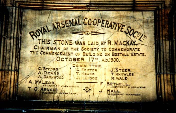
£30,000. In the 16th century Suffolk Place had been a hunting lodge for the Duke of
Suffolk up until 1535. Charles Brandon, Duke of Suffolk, then sold it to Sir Martin
Bowes of Woolwich. By 1720 it had passed into the possession of the New England
Company, which, being an old philanthropic society dating from the reign of James
1st, had its transactions overseen by the Charities Commission. This created some
inconvenience for the R.A.C.S. as the Commission insisting on advertising the sale of
Suffolk Place. This had the effect of bringing a competitor, a Mr Turner, against the
Society.

       A private auction was held on November 1st 1899 in the offices of the Charities
Commission, with Mr Mcleod bidding for the Society and Mr Taylor, a solicitor,
bidding for Mr Turner. The R.A.C.S. finally outbid their rival by £100 and secured
Suffolk Place for £40,000. This gave a purchase price of £318 per acre, almost three
times that of Bostall Farm when acquired some eleven years before.

       The Society planned to use the land to build an estate of about 3,500 houses,
“suitable for the industrial classes”, (1) with prices ranging from £255 to £405 for a 99
year lease. Tenancy agreements with options of purchase would also be available as
well as a few on a weekly tenancy.

       A pamphlet put out by the Society to promote the new estate describes the
location and method of building,

        ‘…The Society’s Bostall Estate is pleasantly situated, adjoining the well
        known Bostall Heath and Woods, which cover an area of 2323/4 acres and
        form one of the most attractive of the open spaces of London.
        It is close to the Abbey Wood Railway Station, and the main road (along
        which it is expected the tram service will shortly be continued) runs through
        the estate. It covers an area of about 120 acres, which it is intended shall be
        laid out in houses suitable to the requirements of the locality. These houses
        will be of various frontages from 15ft to between 17 and 18ft, the smaller
        houses being intended for occupation by one family, whilst in the larger full
        provision is made for their occupation by two families. The work, including the
        surveying and plotting of the estate, the designing of the houses, the road
        making and the sewer construction (2) in connection with the erection of the
        houses, has been done through the Society’s Works Department, and the
        houses are in consequence, constructed in a thoroughly substantial manor
        by labour directly employed by the Society. Trade Union hours have been
        observed, and the wages paid are in no case less than a halfpenny per hour
        above the recognised trade union rate prevailing in the district.

        For the purpose of the development of the estate, extensive workshops have
        been erected, fitted with the latest machinery and most modern labour saving
        appliances, no pains having been spared to ensure that the houses, when
        finished, shall be thoroughly well constructed, at as cheap a rate as it is
        consistent with good work.

              A shaft has been sunk from which chalk is being obtained for use as a
        foundation of the roads. From the shaft also a plentiful supply of water is
        obtained, which is used for the mixing of mortar and other manufacturing

                                                                                        3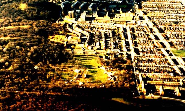
purposes. The window and door-sills, steps, coping, paving flags etc., are
       composed of granolithic artificial stone, manufactured on the estate, the
       durability of which can be guaranteed, and which also possesses other
       advantages over the natural stone commonly used in similar positions…’

      The workshops were erected at the south-eastern portion of the estate in
February of 1900, although the shaft for the chalk mine had been sunk the previous
month. A description of a visit to the works area appeared in the R.A.C.S magazine
in May 1901,(3)

       ‘…Visited in working hours, the first place to be seen is the great carpenter’s
       shed, lofty, lit by electric light, about a hundred feet square. In one corner the
       van making is still being carried on, but this will have a building to itself, the
       great shed being all required for the woodwork of the houses. On the
       opposite, the south of the shed, is the engine, one of 16 horsepower, built by
       Marshal and Son of Gainsborough. By means of 90ft of shafting this little
       engine works a whole series of planing, sawing and other wood-cutting
       machines, a drilling machine and a lathe, the hoist of the chalk pit and the
       water pump attached to the same. It also works the dynamo, which supplies
       the electric light. The different woodcutting machines are arranged in a long
       row, and each is connected with a suction air pump, so that the sawdust and
       shavings are sucked through a series of wooden channels into a central
       receptacle.

              Immediately adjacent to the carpenter’s shed, again on the south side
       of it, is the Smith’s shop, at which all the iron work for the vans (4) is done;
       while just outside is the chalk pit, beside the chalk pit the mortar mill, and just
       beyond the lime kiln. From this centre starts our system of tramways, which
       traverse the field of building operations.

              The chalk pit descends 60ft perpendicularly, from that level four
       galleries extend horizontally about 100ft each, and from these the chalk is
       being continually raised. The water that percolates into the pit is pumped up
       and distributed where needed. Some of the chalk is straightway carted off on
       the tramlines for making the roads, but most of it is first burned in the lime
       kiln, then slaked, then mixed with the fine sand, which by the way, overlies
       the chalk, to make the plaster for internal walls. The grey lime necessary for
       making mortar has to be purchased.

             A little to the west of the carpenter’s shed is the shed in which artificial
       stone is made. This is composed of Portland Cement and fine granite
       chippings, mixed, run into wooden moulds, which are made on the spot,
       deposited in a tank to set, and finally used for sills, copings, pier caps, etc.. In
       the same shed the plaster decorations are made, the cream-like plaster
       being poured into gelatine moulds. Everywhere about these sheds
       telephones are fitted up and connected with the drawing office and the
       central office, whence Mr Bethell directs the labours of his 450 assistants.
       ………’

                                                                                         4
The first brick of the estate was laid on May 28th 1900, and a tablet to
commemorate the event was erected in the following October at the corner of Mcleod
Road and Bostall Lane. When the R.A.C.S. Abbey Wood Branch Store was built on
the spot some time later, the tablet was moved and fixed to the wall facing Bostall
Lane.
Although natural resources were utilised on site, i.e. sand, gravel, chalk etc.,
no suitable brickearth was present in the immediate area so that bricks had to be
purchased from local brickfields. The most probable source was the brick fields along
Wickham Lane some 1.5 Km to the south-west of the new estate. At the end of the
19th century three brickworks were in full operation in that area, producing the
distinctive yellow London stock bricks. (5)
By the latter half of 1903, 350 houses had been leased and 70 let on a weekly
tenancy. The London County Council bought a parcel of land along Bostall Lane from
the Society, and in 1903, built a school for 1000 children. [IMAGE PRICES]
Building continued on the estate until about March 1908 when the Society’s
committee did not wish to proceed with the development faster than the state of the
district demanded. By October 1909 all building work had stopped on the estate. The
chalk mine had ceased operation three years before, although it features in the
Inspector of Mines Reports until1912. (From 1907 to 1912 both workforce and output
were given as nil)
As demand built up, building work re-started in 1912 and continued until
1914. The chalk mine, however, did not re-start during this period. It is probable that
the site had a stockpile of previously excavated chalk, which was sufficient for the
new demand. When completed a total of 1,052 houses had been erected on the
estate. With the estate finished all the workshops were dismantled, the shaft to the
chalk mine was capped with a steel grill and the Works Department moved back to
their headquarters in Powis Street, Woolwich. The works canteen was, however, not
demolished but left to the new local community and named the Co-operative Hall. It
was later re-named Federation Hall and used for many years by the local authority
social services department as a day centre. The London Borough of Greenwich, who
5had leased the Hall and adjacent land, finally purchased the land from the R.A.C.S.
in 1975.
The building of the Estate was a bold venture for a relatively young Co-
operative society in the 1900’s, and was a ‘model’ estate when completed. The
houses and roads of the estate have now been absorbed in the urban expansion
between Plumstead and Abbey Wood and little remains to remind modern visitors of
its origins. Only the road names give a clue to Co-operative movement’s involvement
– Federation Road, Congress Road, Conference Road, etc.
The Chalk Mine
The 8ft (2.4m) diameter shaft was sunk in January 1900 in a corner of the
works area near to the mortar mill and limekiln. (NGR TQ 4717 7852)
Four main headings were driven from the base of the 53ft (16.17m) deep shaft to
commence mining operations. At that time the floor of the mine was on or just below
the water table as the mine was also used to supply water for the manufacturing
processes on the surface.
The mine was drained by pumps driven by the 16hp surface engine, which
also powered the winding hoist and provided electric power for lighting the
underground tunnels. This was a most unusual feature as most mines of this period
were worked by the illumination of candles or oil lamps.
In the first full year of operation four men worked underground cutting out the
chalk with picks and wheeling the excavated material to the shaft bottom in barrows.
Two men were employed on the surface to unload the chalk from the tub and barrow
it either to the limekiln or to a nearby dump for collection by the road building gangs.
6By 1902 the workforce had increased to six men underground and four on the
surface. From 1903 until 1906 the figures were five below and two above ground.
After 1906 the mine had ceased operation. (6)
For the first two years of its life the mine was recorded in the Inspector of
Mines Reports as ‘Suffolk Place Mine’. From 1902 it was shown as the Bostall Estate
Mine. Originally the mine had been named after the land on which it was situated –
Suffolk Place Farm, one of the two parcels of land that made up the development.
The committee of the R.A.C.S., however, finally chose to name the estate after the
first farm they hade purchased in 1887 – Bostall Farm. This dual naming of the mine
has, in the past, lead to erroneous fears that another deep mine existed under the
estate.
In 1914 the underground galleries of the mine were converted into an air-raid
shelter by the addition of a sloping entrance by the side of the Co-operative hall. The
shaft provided excellent ventilation but, as the floor of the mine was wet, boards had
to be laid on the floor. Electric lighting was provided and the local residents
considered the chalk caves a very safe refuge. With the coming of the Second World
War the mine was once again considered as a shelter and Howard Humphreys and
Sons of Westminster made a detailed plan of the workings for the local authority.
Despite strong protests from the local residents who all wished to use the deep caves
as in WW1, it was decided by the controlling authorities that the mine was no longer
suitable as a deep shelter due to the lack of a second exit.
The underground galleries remained accessible up until the 1960’s when it
was still possible to crawl into the now rubbish filled 1914 entrance adit. Harry
Pearman of the Chelsea Speleological society entered by this method in 1960 and
produced a quick survey plan (7). Shortly after this time the sloping entrance was
completely filled by the local authority following fears that children, who were known
to explore and play in the caves, could become lost or injured.
1967 Investigation
The next visit to the site was in 1967 when, with the kind permission of the
R.A.C.S. and the Local Authority, a small group of mining archaeologists lead by the
writer made an examination and re-survey of the underground galleries. The strong
steel grill sealing the top of the shaft was removed by workmen from the London
Borough of Greenwich, (the principle Lessee of the site) in order to gain access.
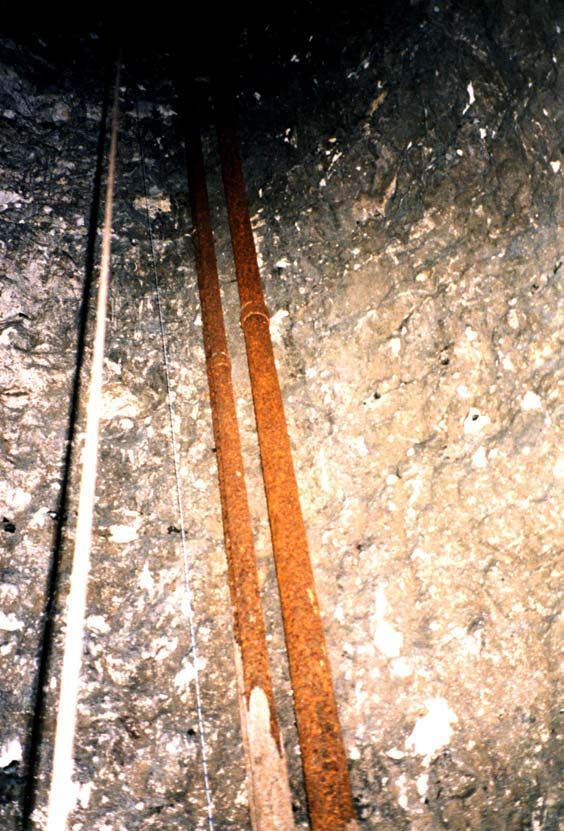
7The mine was found to be in
excellent condition with no roof falls or
signs of stress in the walls. The galleries
averaged 10ft (3m) wide and 18ft (5.5m)
high with an arched roof profile, which gave
a mechanically strong cross section. The
junctions of galleries were cut with great
care to ensure that weight of the land
above was spread correctly. The highest
tunnels were to the south of the shaft
where the main development of the mine
took place, with the roof being 20ft (6m)
high in this section.
8Only three galleries were dug to the north of the shaft and were much lower,
in the order of 11ft (3.3m) high. In that part of the mine the depth of the roof below
the surface is only about 17ft (5.18m). The excavators wisely did not extend the mine
further in this direction as the surface slopes down to the north and the roof cover
would have been decreased to a point when the risk of subsidence would have
become acute.
The mine proceeded forward in a series of steps or benches, the miners
cutting away their working platform as the adit was extended. Such working benches
can be seen in any chalk mine and their presence has lead to tales of Druid’s altars
in some tourist caves.
The final layout of the mine developed from the four original galleries radiating
from the shaft. From these main driveways other adits were cut at right-angles to be
joined by cross passages which created large pillars of chalk to support the ground
above, a style of mining known as ‘Pillar and Stall’. From a careful study of the
9underground galleries and the tool marks left by the miners, it is possible to re-
construct the probable development sequence of the mine.
The last section of the mine to be worked was an extension to the south when
a further 180ft (54.8m) of passages were excavated in 1906, the last year of
operation.
10The final addition to the mine was made in 1914 when the sloping drift
entrance was dug at the side of Federation Hall to enable the underground tunnels to
be used as an air-raid shelter. The sloping tunnel from the surface was intercepted
by another dug from the main east driveway of the mine to create the shelter
entrance. Although the water table had dropped since the mine was abandoned, it
was found necessary to put boards and gravel on the floor, as parts of the mine were
wet. In 1967 no water was present, although a long period of dry weather had
preceded the date of the investigation. The metal pipes used to pump water to the
surface when the mine was in operation were found to be still in situ in the south east
quadrant of the circular shaft.
By 1939 parts of the entrance drift had fallen in and it was declared unsafe.
This instability, plus the lack of a second exit, stopped the mine being used as a
shelter in the Second World War, despite vigorous protests from the local residents.
Upon completion of the two-day investigation of the mine in 1967, the shaft
was re-sealed and made safe. The original steel grill was replaced by a strong
reinforced concrete slab to stop any unauthorised access.
112004 Survey
In February 2004 the mine was re-entered by members of the Kent
Underground Research group on behalf of Stonechart Developments Ltd, a
building development company, who had purchased the parcel of land
containing Federation Hall and the shaft top from the local council. At the time
of this visit most of the mine was found to be flooded to a depth of 0.5 to over
1.0m in depth. Apart from the water, no significant changes in the condition of
the mine since 1967 could be detected. After the visit the shaft was once again
sealed and made safe and at the time of writing (April 2004), plans for the
redevelopment of the surface land were well advanced.
(1) ‘Comradeship’ No 14 May 1900
(2) As well as the house sewers, a 24-inch (60cm) main sewer was laid along the
length of Mcleod Road.
(3) ‘Comradeship’ No 26 May 1901
(4) As the whole of the Society’s Works Department had moved to the
construction site, normal work was carried out at the new location, such as the
construction of delivery vans etc.
(5) The three brickfields were: Wickham Lane (also known as Gregory’s), South
Metropolitan and Cemetery. Each had its own deep chalk mine.
(6) H. M. Inspector of Mines Reports 1900 to 1906
(7) Chelsea Speleological Society Records vol. 6 p53
12You can also read