The spatial distribution of potential fishing grounds in Riau Archipelago, identified with MODIS-AQUA, based on monsoon seasons differences
←
→
Page content transcription
If your browser does not render page correctly, please read the page content below
The spatial distribution of potential fishing
grounds in Riau Archipelago, identified with
MODIS-AQUA, based on monsoon seasons
differences
1
  Risandi D. Putra, 1Anton H. Yunianto, 1Eko Prayetno, 2Mario P. Suhana,
1
  Deny Nusyirwan, 3Sapta Nugraha, 2Abdul R. Ritonga, 3Hollanda A.
Kusuma, 4Dwi E. D. Setyono
    1
    Department of Naval Architecture, Faculty of Engineering, Maritim Raja Ali Haji of
University, Tanjungpinang, Riau Archipelago, Indonesia; 2 Department of Marine Science,
  Faculty of Marine Fisheries, Maritim Raja Ali Haji of University, Tanjungpinang, Riau
 Archipelago, Indonesia; 3 Department of Electrical Engineering, Faculty of Engineering,
     Maritim Raja Ali Haji of University, Tanjungpinang, Riau Archipelago, Indonesia;
    4
      Research Unit for Natural Product Technology, Indonesian Institute of Sciences,
        Indonesia. Corresponding author: E. Prayetno, ekoprayetno@umrah.ac.id

        Abstract. It is necessary to identify potential fishing areas to achieve maximum marine fishery
        production value in the Riau Islands. Remote sensing application is considered to be the more accurate,
        effective, efficient and responsive in accommodating the determination of potential fishing ground
        locations over a large area. The potential fish ground areas were obtained through three stages of
        analysis with remote sensing technology, on the Aqua MODIS platform. The first analysis was the
        preprocessing analysis using the SeaDas software to reproject image data. The second stage was
        processing data through ER Mapper software for the cropping process. Two primary data variables,
        particularly Sea Surface Temperature (SST) and chlorophyll-a (Chl-a) concentration, where input is
        related to a suitable habitat for pelagic fish. The last stage was a post-processing analysis to obtain a
        contour image of the fishing ground location by mapping the crossover from SST and the chlorophyll-a
        concentration variables, using the Arc-GIS software. The remote sensing analysis of the sea surface
        temperature and chlorophyll-a concentration, based on the monsoon differences, using the Aqua MODIS
        satellite imagery, showed that most of the fishing ground points located in Riau Islands were in the
        northern monsoon zone. In comparison, the lowest number of fishing grounds occurs in the southern
        season. Bintan, Batam, Karimun, and Lingga (BBKL) is an area that has the most fishing ground
        compared to Natuna and Anambas among the three research areas in the Riau Islands.
        Key Words: chlorophyll-a, fishing ground, sea surface temperature, Riau Islands, remote sensing.

Introduction. The potential of fisheries production in the Riau Islands province is
included in the Fisheries Management Area of the Republic of Indonesia (WPP-NRI)
designated by the Minister of Marine Affairs and Fisheries Regulation Number PER.01/
MEN/2009 concerning the Fisheries Management Area of the Republic of Indonesia. Data
on the study of marine resource potential in Riau Archipelago Province in 2018 indicates
that from the seawater area of 24,121.530 ha (95.79%), the fisheries production in Riau
Islands was estimated to reach 1,500.000 tons year-1 (Bobby 2017). The potential high
fishery product in the Riau Archipelago seawaters is located in the Coral Triangle area.
This region is located along the equator between the Indian and Pacific Oceans and is a
global hotspot for the marine biodiversity in the world (Asaad et al 2018; Putra et al
2018; Teh et al 2018).
        This marine biodiversity plays a crucial role in both fishery and tourism activities
(Licuanan et al 2016). Unfortunately, marine biodiversity, marine ecosystems and fishery
resources in the Coral Triangle region, including in the Riau Archipelagos seawater area,
are at risk, due to the anthropogenic pressures, among which an intensive exploitation,

AACL Bioflux, 2021, Volume 14, Issue 3.
http://www.bioflux.com.ro/aacl
                                                      1383
and their environmental sustainability is declining (Hoegh-guldberg et al 2018; Mcleod et
al 2019; Putra et al 2018). The industrialization of fishing vessels, the excessive
exploitation of marine products and the rampant illegal fishing in the North Natuna Sea
have caused a decline in the marine products, especially in the Riau Archipelagos
Province seawaters area. Previous research has confirmed that the main factor driving
this drastic decline in marine products was illegal fishing (Haridhi et al 2016; Mohanty et
al 2017).
         According to the Ministry of Marine Affairs and Fisheries (MMAF), apart from the
anthropogenic threats in the Riau Archipelago seawaters area, another fundamental
problem is that the utilization of marine and fishery resources of the area by local fishers
was still deficient, with a production of only around 5% of the total potential. The low
utilization of fisheries production in the Riau Archipelago region did not support the
marine sector's economy. Based on data reported from the MMAF (2020), the production
of marine fisheries in the Riau Archipelago was still far from the maximum potential
value: only 407,235.91 tones were utilized. On the other hand, the Natuna island part of
Riau Archipelago Province has one of Indonesia's largest potentials for fishery resource,
with an estimated yield of fishery products of 148,879.23 tons. Several factors contribute
to the sub-optimal resource exploitation in Riau Islands, such as the use of a
conventional fishing gear, a limited fishing technology and a lack of appropriate fishing
vessels, causing local fishermen to have a limited access to the fishing grounds. Seasonal
changes in the Riau Islands also significantly impact the decline in local fishery products
by constraining the traditional fishing activities.
         It is necessary to identify the potential fishing grounds’ location to reach the
maximum value production and to increase marine fishery products in the Riau
Archipelago. Remote sensing is the fastest and most responsive method to localize the
potential fishery grounds. Offshore fisheries monitoring using remote sensing has been
developed over the last few decades (Rowlands et al 2020). Several algorithms based on
remote sensing techniques have been introduced to detect and monitor oceanographic
phenomena, to identify the marine areas fishing potential (Babu et al 2016; Mohanty et
al 2017; Putra et al 2018). The high spatial and temporal resolution of remote sensing
can define large fishing zones (Mohanty et al 2017). The remote sensing satellites have
helped identifying surface features such as changes in seawater temperature, chlorophyll
concentration, upwelling phenomena, eddies, gyres, tidal patterns and all variables
influencing the discovery of Potential Fishing Ground locations, globally (Mohanty et al
2017). This study uses a remote sensing approach using satellite imagery of the
Moderate Resolution Imaging Spectroradiometer (MODIS)-AQUA and data from Global
Fishing Watch (GFW) to determine the potential fishing ground areas and the proper
fishing time in Riau Archipelago seawater area based on the monsoons influence.

Material and Method

Description of the study sites. The Riau Islands seawaters are an extensive area in
Indonesia. The location is the border with Singapore, Malaysia, and Thailand. Among the
six main islands in the Riau Archipelago, the seawater depth reaches more than 300 m in
Natuna and Anambas. Both seawaters location is the strategic area for fishing small and
big pelagic fishes. The selection of research locations was based on the location of the
productive fishing area by local fishermen (Solanlki et al 2001). Particularly in this study,
the research location conducted in the six main islands in the Riau Archipelago with three
large group seawater areas, including in Monitoring Area 1 (Bintan, Batam, Karimun
Lingga), Monitoring Area 2 at the Anambas seawater location, and monitoring Area 3 at
the Natuna seawater location (Figure 1).

AACL Bioflux, 2021, Volume 14, Issue 3.
http://www.bioflux.com.ro/aacl
                                            1384
Figure 1. The research location of potential fishing ground area in Riau Archipelago based
 on different monitoring area, inculidng area 1 (Bintan, Batam, Karimun, Lingga), area 2
                         (Anambas Islands) and area 3 (Natuna).

The remote sensing image source. Satellite image data used to determine potential
fishing locations is a product derived from MODIS (Resolution Imaging Spectrometer
resolution) sensors using NASA satellite images record in every monsoon during one-year
analysis in 2019 downloaded from http://daac.gsfc.nasa.gov/data. The collected data
were analyzed based on the monsoon seasons differences. The primary data used were
sea surface temperature and chlorophyll-a concentration. The remote sensing data set
from the MODIS satellite, obtained on the Aqua platform, is used to detect global
differences in the ocean's color, by analyzing the variables Sea Surface Temperature
(SST) and chlorophyll-a concentration. Changes in sea surface temperature (in oC) and
chlorophyll-a concentration variables (in mg m-3) are caused by oceanographic processes
that also trigger changes of the potential fishing areas. SST data and chlorophyll-a
concentration were observed in L3 format (Level 3) mapped in HDF format with a
resolution of 4 km. The data was processed through three stages of analysis: pre-
processing, processing and post-processing of image data, using the softwares SeaDass,
ER Mapper and Arc-GIS, respectively.

The data analysis. Sea surface temperature and chlorophyll-a concentration data were
analyzed in three stages. The first analysis was the pre-processing analysis to ensure
that the downloaded satellite image data has the World Geodetic System (WGS) 84
format, used as the cartography standard (Boucher & Altamimi 2001). SeaDas software
was used for reprojecting the analytical data in the form of GeoTiff format. The second
stage was the data processing through the ER Mapper software for the cropping process.
The model variables are used to input the two-primary data of SST and chlorophyll-a
concentrations (Chl-a), suitable for pelagic fish detection. The last step is the post-
processing analysis, intended to obtain a contour image of the potential fishing zone
location by mapping the intersecting SST and chlorophyll-a concentration variables, using
the Arc-GIS Software. The estimation of fishing grounds is a confluence between sea
surface temperature and corresponding chlorophyll-a concentration (Santos 2000).

Results

The distribution of chlorophyll-a (Chl-a) concentration. The distribution of
chlorophyll-a (Chl-a) concentration in the Riau Archipelago (Figure 2) in the north
monsoon shows that the Chl-a concentration in area 1 - Bintan Batam Karimun Lingga

AACL Bioflux, 2021, Volume 14, Issue 3.
http://www.bioflux.com.ro/aacl
                                          1385
(BBKL) tends to be higher in the western side, ranging between 0.37 and 0.43 mg m-3.
The distribution of Chl-a concentrations in area 2-Anambas shows a higher chlorophyll-a
concentration value in the southern part, ranging between 0.31 and 0.43 mg m-3. The
Natuna Island had a higher concentration of Chl-a directly to the mainland, ranging
between 0.29 and 0.43 mg m-3. East monsoon changes the distribution of chlorophyll-a
concentrations in the monitoring area 2 (Anambas Islands) and shows that the
distribution of Chl-a tends to be more even in almost all seawaters areas, with Chl-a
concentrations of 0.10-0.23 mg m-3. The southern monsoon shows a similar distribution
pattern of the Chl-a concentration as the previous monsoon, but the value of the Chl-a
concentration was increased: 5.42-9.41 mg m-3 in BBKL, 0.13-0.40 mg m-3 in the
Anambas Islands and 2.18-3.22 mg m-3 in the Natuna Island. The peak of the Chl-a
concentration increase in the Riau Islands was observed in the west monsoon, cncerning
almost all areas.

   Figure 2. The distribution of chlorophyll-a (Chl-a) concentration: in north and east
 monsoons (top); in south and west monsoons (bottom); at each research location: Area
  1 (Bintan, Batam Karimun Lingga), Area 2 (Anambas Islands) and Area 3 (Natuna).

AACL Bioflux, 2021, Volume 14, Issue 3.
http://www.bioflux.com.ro/aacl
                                          1386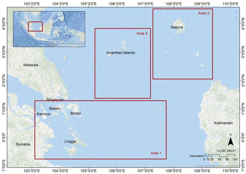
The distribution of sea surface temperature (SST). The distribution of sea surface
temperature in BBKL is higher in the western part, with SST values ranging from 29.19 to
30.19oC. In contrast, the SST distribution in the Anambas and Natuna Islands tends to be
more even, with SST values ranging from 27.66 to 30.19oC and 27.66 to 30.19oC,
respectively. The distribution of SST in BBKL locations tends to be higher in the northern
part, in the southern season, whereas in the eastern part of BBKL, the SST distribution
tends to be lower, with concentration values ranging from 27.77 to 29.98 oC. Based on
Figure 3, in the southern season, the SST distribution in the BBKL locations tends to be
higher in the western part, with SST values ranging from 31.21 to 32.99 oC. The SST
distribution in the Anambas and Natuna Islands locations was similar to the western
season: more evenly distributed in each Island location, with SST values ranging from
27.90 to 32.99oC and 27.91-32.99oC, respectively.

     Figure 3. The distribution of sea surface temperature concentration for the north
     monsoon, east monsoon, south monsoon and western monsoon (from top to the
    bottom), in each research location Area 1 (Bintan, Batam Karimun Lingga), Area 2
                          (Anambas Islands) and Area 3 (Natuna).

AACL Bioflux, 2021, Volume 14, Issue 3.
http://www.bioflux.com.ro/aacl
                                          1387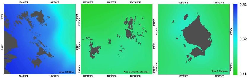
The distribution of potential fishing ground in the Riau Archipelago. In the
northern monsoon (December-February), 764 fishing points were found scattered
throughout the Natuna seawaters. In this season, the rainfall is higher, and the sea
surface temperature in Natuna was suitable for several pelagic fish species’growth. The
northern season shows that seawaters in Natuna receive an additional nutrient content
from land, due to the rainfalls. The Anambas seawaters counted 413 fishing ground
points scattered in almost all seawaters location, bordering both the coast and the
offshore region. The analysis counted 884 points of fishing ground located around the
BBKL seawaters, the largest number of the three mapping areas in Riau Archipelago, for
the northern monsoon (Figure 4).

    Figure 4. The fishing ground point during the northern monsoon, at each research
 location: Area 1 (Bintan, Batam Karimun Lingga), Area 2 (Anambas Islands) and Area 3
                                        (Natuna).

The number of fishing grounds in Natuna during the eastern monsoon (March-May) was
of 124, based on the data analysis. This monsoon tends to be dry due to the lack of rain
intensity, which affects the plankton development by photosynthesis and causes a
decrease in the land's nutrient intake. During the eastern monsoon period, the Anambas
Islands had 162 fishing ground points, tending to decrease, compared to the northern
monsoon, due to the rising sea surface temperatures and to the low rainfall. The fishing
ground locations for the Bintan, Batam, Karimun and Lingga (BBKL) regions in the
eastern season also decreased, compared to the northern monsoon. The number of
fishing ground points found in BBKL during the easter monsoon was of 439 points (Figure 5).

  Figure 5. The fishing ground point during the eastern monsoon, at each research location:
  Area 1 (Bintan, Batam Karimun Lingga), Area 2 (Anambas Islands), and Area 3 (Natuna).

The southern period (June-August) made the transition from the dry season to the rainy
season, and affected the oceanographic factors influencing the fishing zone (Figure 6).
The southern monsoon increased the chlorophyll-a condition in Natuna seawaters, but
decreased the SST, rendering the pelagic fish habitat optimal. There has been an

AACL Bioflux, 2021, Volume 14, Issue 3.
http://www.bioflux.com.ro/aacl
                                            1388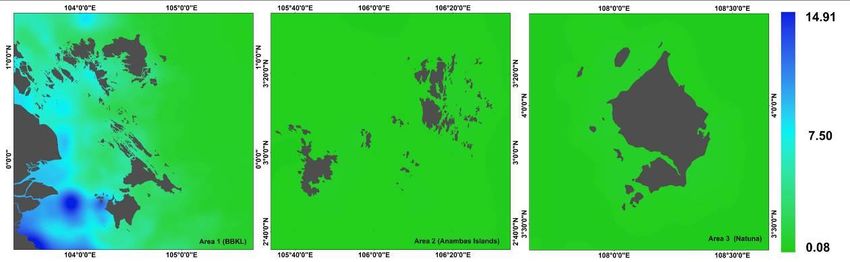
increase in the count of fishing ground locations in Natuna from the previous monsoon
with 201 fishing ground points, almost evenly distributed throughout the Natuna
seawaters. In Anambas seawaters, 237 fishing points were found scattered along the
coast and in the the offshore area, more than in the eastern monsoon. The distribution of
Chl-a in Anambas increased in this monsoon and the SST decreased drastically,
compared to the previous monsoon. In the seawaters of Bintan, Batam, Karimun and
Lingga (BBKL), there were found 252 fishing ground points, with most of the fishing
points being found in Lingga waters. The distribution of fishing points in this season,
throughout the BBKL waters, did not significantly differ of the Anambas and Natuna
Islands.

 Figure 6. The fishing ground point during the southern monsoon, at each research location:
  Area 1 (Bintan, Batam Karimun Lingga), Area 2 (Anambas Islands), and Area 3 (Natuna).

In the western monsoon period (September-November), at the beginning of the rainy
season with an increasing rainfall intensity, in the Natuna seawaters were counted 124
fishing points. The increased rainfall in this monsoon affects the fishing grounds.
However, the sea surface temperature was still warm enough this monsoon.
Consequently, the potential of the fishing grounds did not record a significant increase. In
the western monsoon period, in Bintan, Batam, Karimun and Lingga, there were found
387 points of fishing ground. The dominant distribution points of fishing ground locations
in BBKL were scattered in the Lingga seawaters. During this season, the sea surface
temperature in BBKL is lower than in Natuna and Anambas, and also lower than in the
previous season. In the Anambas seawaters, there were discovered 138 points with
fishing potential, scattered in almost all areas of the Anambas seawaters. In this
monsoon, in the Anambas Islands there was an increased intensity of rainfalls and of
chlorophyll concentrations. Fishing grounds point in the western monsoon are shown in
Figure 7.

Figure 7. The fishing ground points during the western monsoon, at each research location:
 Area 1 (Bintan, Batam Karimun Lingga), Area 2 (Anambas Islands), and Area 3 (Natuna).

AACL Bioflux, 2021, Volume 14, Issue 3.
http://www.bioflux.com.ro/aacl
                                           1389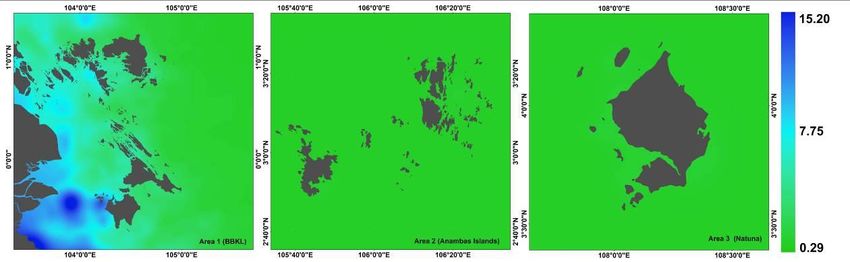
Discussion. Our results show that seasonal changes strongly influence each fishing
grounds area in the Riau Islands (BBKL, Anambas Islands, and Natuna) (Figure 8). These
results also support a previous research of Sachoemar (2015), which shows that fishing
grounds are very dynamic being influenced by the seawater conditions’ fluctuations. The
always changing aquatic environmental conditions determine fish migratory movements
for finding the more suitable habitat for living, growing and foraging (Tesfay 2016). A
previous research from Laevastu & Hayes (1981) emphasized that the surrounding
aquatic environment influences the pelagic fish distribution, according to the most
appropriate environmental conditions that suit their organisms. The existence of a
suitable fish habitat depends on several factors, such as the adequate food availability
and safety level, in terms of predators and competitors (Aadland 1993) and the suitable
oceanographic conditions, including the water flow, dissolved oxygen, chlorophyll-a
concentration, density of macro-benthic sediment, pH and particulate organic carbon
(POC) (Ansari et al 2003).
        Previous research from Chavula et al (2012) stated that several oceanographic
conditions such as the sea surface temperature, chlorophyll, salinity, ocean depth, and
currents significantly influence the fish habitat and are suitable for an accurate
identification of the fishing ground area. The sea surface temperature and chlorophyll-a
concentration are the two most significant factors for mapping the distribution of fishing
grounds. The chlorophyll-a concentration variable for quantifies the distribution of
phytoplankton biomass which the main fish food, being consideredan indicator of the
trophic state index (Robles-Tamayo et al 2020). The sea surface temperature level (SST)
serves to identify the suitability of the fish habitat distribution (Nurdin et al 2017) for an
increased productivity (Khrystenk et al 2015). The multiple regression of the sea surface
temperature and chlorophyll-a concentration with the catch of pelagic fish in the eastern
monsoon resulted in a correlation coefficient of 0.86 (Masturah et al 2014). The value
means that the relationship between sea surface temperature and chlorophyll-a
concentration with pelagic fish was high. A similar result was obtained by Welliken et al
(2018), using the squared polynomial analysis method between chlorophyll-a and
mackerel fish catch, with a coefficient of determination (R2) of 0.890. The value means
that a proportion of 89% of the mackerel fish catches in the Arafura Sea is affected by
the chlorophyll-a. The correlation coefficient (r) was 0.934, which indicates that the
relationship between chlorophyll-a and mackerel fish catches was strong.

  Figure 8. The sea surface temperature value ranges in Riau Archipelago area (Natuna,
                           Anambas, BBKL), for each monsoon.

AACL Bioflux, 2021, Volume 14, Issue 3.
http://www.bioflux.com.ro/aacl
                                            1390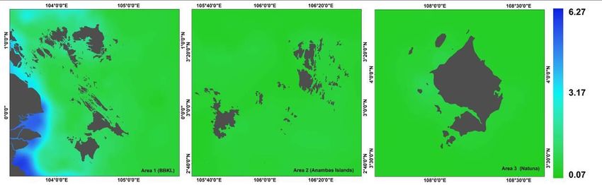
Our results show that the northern monsoon is correlated to the largest number of fishing
ground point locations in the Riau Islands. The distribution of SST in this monsoon has a
significant influence on the distribution of fishing grounds in the Riau Islands because the
sea surface temperature in this monsoon is optimalfor the pelagic fish habitat. In
comparison, the sea surface temperatures in the western monsoon, in most of the Riau
Islands seawaters, increased significantly, causing a decrease of the number of potential
fishing grounds. Nurdin et al (2017) explained that an increase of 1.80°C in the SST
resulted in a drastic decrease in the pelagic fishing potential. Temperature plays an
essential role in the pelagic fish distribution, determining changes in the chlorophyll
concentration in seawaters and acts as an indicator of the fish schooling locations in
tropical oceans (Dutta et al 2016).
        In the east and south monsoons, chlorophyll concentration dramatically affects
the potential points of fishing ground (Figure 9). The increase in the number of fishing
grounds in the eastern monsoon in most of the Riau Islands is due to an increase in the
chlorophyll-a concentrations. Sachoemar (2015) showed that the increase of chlorophyll-
a concentration correlates significantly with the fish catch and Nurdin et al (2017)
explained that the increase in the potential fishing zone is caused by a high chlorophyll
concentration (Chla-a). Our results show that an increase in the chlorophyll concentration
the eastern monsoon is due to the effect of high precipitation. Precipitation affects the
enrichment of the coastal area in the BBKL area, due to the enhancement of the nutrient
concentration through several rivers. Sachoemar (2015) also explained that high
precipitation caused the nutrient concentration enrichment. Our study results indicate
that the concentration of chlorophyll-a, especially in the BBKL area, tends to be higher in
in the coastal seawaters and lower in the offshore area. The distribution pattern of
chlorophyll tends to be high in the coastal areas due to the supply of large amounts of
nutrients through run-off from land. Our research also supports the previous research of
Prasetiahadi (1994), which explains that chlorophyll-a in seawater tends to be higher in
the coastal areas than in the offshore areas.

 Figure 9. The chlorophyll-a concentration (Chl-a) values range in Riau Archipelago area
                     (Natuna, Anambas, BBKL), for each monsoon.

Based on our research results, we concluded that a high chlorophyll-a concentration in
the seawater increased the number of potential fishing ground points. During the
observation of the fishing grounds distribution in the Riau Islands area, the chlorophyll-a
concentration values ranged between 0.1-9.41 mg m-3. A too-high value of chlorophyll
concentration can cause eutrophication and algal blooming, impacting the seawater
quality. According to Bohlen & Boynton (1966), the seawaters with a chlorophyll-a

AACL Bioflux, 2021, Volume 14, Issue 3.
http://www.bioflux.com.ro/aacl
                                           1391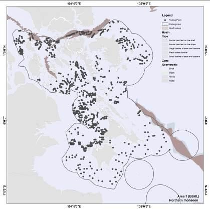
concentration 30 mg m-3 they are
categorized as poor, indicating the occurrence of eutrophication (polluted). Based on this
classification, the Riau Islands seawaters have a chlorophyll-a concentration suitable for
fisheries. Gower (1972) showed that chlorophyll concentrations above 0.2 mg m-3
indicate the presence of sufficient planktonic biomass to sustain a viable commercial
fishery. Semedi & Hadiyanto (2013) also show that some highly abundant pelagic fish are
mostly captured in the seawater areas with chlorophyll-a concentrations ranging from 0.3
to 2.8 mg m-3.
        A comparative study showed that Chl-a concentration are higher near Sumatera
Island, due to the nutrients from the river mouths, the main factor regulating the
phytoplankton development especially nearshore (Damar et al 2020). The distribution of
Chl-a in Anambas and Natuna showed no difference between the monsoon season and
shows that only land on the two islands affects the chlorophyll-a concentration in the two
islands' seawater area. This also indicates that the mainland of Kalimantan and Malaysia
with high chlorophyll-a concentrations and close to the Anambas and Natuna Islands did
not influence chlorophyll-a concentrations in both of seawaters area. This result is similar
to Yu et al (2019), who found a higher Chl-a level near the coast and lower in the South
China Sea. Hao et al (2019) suggest that high Chl-a patterns not only rely on the nutrient
supply, but also relate to light conditions controlled by vertical mixing and suspended
matter. The different Chl-a annual cycles are mainly caused by the fluctuationsof nutrient
concentrations and of light intensity, and thus their distributions tend to vary with the
water depth. According to Martin (2014), phytoplankton is at the base of the marine food
web, also contributing to the global carbon cycle. Chlorophyll-a is an indicator of the
productivity of the waters which has an indirect relationship with the fishing ground.
Siregar & Waas (2006) reported that monsoons and sea surface temperature determined
the distribution of Chl-a, but other environmental factors also influenced it (such as the
atmospheric conditionsand the sea level fluctuations).
        The Riau Islands seawaters belong to one of the tropical oceanscharacterized by a
thin, permanent, shallow layer of warm water over deeper, colder water (Stewart 2008).
The variation of the atmospheric circulation in the tropical ocean finds its parallel in a
corresponding variation of the oceanic circulation. Because of the high constancy of the
monsoons and of their regular appearance, the ocean currents show the same
characteristics. The monsoon changes its direction twice a year reversing the winds at
the time of their strongest development, and the oceanic circulation is also reversed in
large areas. Thus, this complete reversal is really typical of the circulation in these waters
(Wyrtki 1961). The sea surface temperature distribution in determined by the rain
intensity. The SSTs during the south and western monsoon were higher than during the
north and eastern monsoon. This phenomenon happens because the north and eastern
monsoon is the rain season, with decreasing SSTs. The annual variability of the SST and
Chl-a is influenced by the monsoon systems (Mashita & Lumban-Gaol 2019). High
concentrations of chlorophyll generally occur during the same monsoon period as the
lowest SST values, although the locations can be different. Low SST and high chlorophyll
indicate upwelling (Mashita & Lumban-Gaol 2019). That’s why many fishing ground spots
occur in western part of Lingga and southern part of Batam. Wyrtki (1961) stated that
over shallow waters, the regeneration of the sinking material occurs at the bottom and
the nutrients can easily be brought into the euphotic zone by vertical mixing.
Consequently, a continuous supply of nutrients to the water masses takes place, enabling
a continuous production. This process makes large parts of the shelves quite fertile and
maintains a big stock of fish.

Conclusions. The remote sensing cross-analysis results between sea surface
temperature and chlorophyll-a concentration, based on differences in monsoons and
using Aqua MODIS satellite images, found that the largest number of fishing ground
spots in the Riau Islands were in the northern season. BBKL was the region with the
largest count of fishing grounds compared to Natuna and Anambas based on three
research areas (Natuna, Anambas, and BBKL) in Riau Islands.

AACL Bioflux, 2021, Volume 14, Issue 3.
http://www.bioflux.com.ro/aacl
                                            1392
Acknowledgments. The authors would like to thank the Maritime Raja Ali Haji
University (UMRAH) grant for financial support
Conflict of interest. The authors declare no conflict of interest.
References
Aadland L., 1993 Stream habitat types: Their fish assemblages and relationship to flow.
North American Journal of Fisheries Management 13(4):790-806.
Ansari Z. A., Sreepada R. A., Dalal S. G., Ingole B. S., Chatterji A., 2003 Environmental
influences on the trawl catches in a bay-estuarine system of Goa, west coast of
India. Estuarine, Coastal and Shelf Science 56(3–4):503-515.
Asaad I., Lundquist C. J., Erdmann M. V., Costello M. J., 2018 Delineating priority areas
for marine biodiversity conservation in the Coral Triangle. Biological Conservation
222:198-211.
Babu M. J., Geetha P., Soman K. P., 2016 MODIS-Aqua data based detection and
classification of algal blooms along the coast of India using RLS classifier. Procedia -
Procedia Computer Science 93:424-430.
Bobby B. A., 2017 Indonesian government efforts for cope off illegal fishing in the Riau
Archipelago 2010-2015. e-Journal of International Relations 5(4):1381-1396.
Bohlen C., Boynton W., 1966 Chlorophyll in mid Atlantic estuaries. US EPA MAIA, 10 p.
Boucher C., Altamimi Z., 2001 ITRS, PZ-90 and WGS 84: Current realizations and the
related transformation parameters. Journal of Geodesy 75:613-619.
Chavula G., 2012 Mapping potential fishing grounds in lake Malawi Using AVHRR and
MODIS satellite imagery. International Journal of Geosciences 3:650-658.
Damar A., Colijn F., Hesse K. J., Kurniawan F., 2020 Coastal phytoplankton pigments
composition in three tropical estuaries of Indonesia. Journal of Marine Science and
Engineering 8(5):311, doi:10.3390/jmse8050311.
Dutta S., Chanda A., Akhand A., Hazra S., 2016 Correlation of phytoplankton biomass
(Chlorophyll-a) and nutrients with the catch per unit effort in the PFZ forecast areas
of Northern Bay of Bengal during simultaneous validation of winter fishing season.
Turkish Journal of Fisheries and Aquatic Sciences 16(4):953-959.
Gower J., 1972 Opportunities and problems in satelite measurement of the distribution of
phytoplankton in eutrophic coastal waters. Australian Journal of Marine Freswater
Research 189:40-559.
Hao Q., Chai F., Xiu P., Bai Y., Chen J., Liu C., Le F., Zhou F., 2019 Spatial and temporal
variation in chlorophyll a concentration in the Eastern China Seas based on a locally
modified satellite dataset. Estuarine, Coastal and Shelf Science 220:220-231.
Haridhi H. A., Nanda M., Wilson C. R., Rizal S., 2016 Preliminary study of the sea surface
temperature (SST) at fishing ground locations based on the net deployment of
traditional purse-seine boats in the northern waters of Aceh — A community-based
data collection approach. Regional Studies in Marine Science 8(1):114-121.
Hoegh-Guldberg O., Kennedy E. V, Beyer H. L., Mcclennen C., Possingham H. P., 2018
Securing a long-term future for coral reefs. Trends in Ecology & Evolution 33(12):
936-944.
Khrystenk D., Kotovska G., Novitskij R., 2015 Metabolic potential, respiration rate and
their relationship in offspring of different sizes of marble trout (Salmo marmoratus
Cuvier). Turkish Journal of Fisheries and Aquatic Sciences 15:609-618.
Laevastu T., Hayes M. L., 1980 Fisheries oceanography and ecology. Fishing News Books,
Farnham, 199 p.
Licuanan W. Y., Robles R., Dygico M., Songco A., Woesik R. V., 2016 Coral benchmarks
in the center of biodiversity. Marine Pollution Bulletin 114(2):1135-1140.
Martin S., 2014 An introduction to ocean remote sensing. Cambridge University Press,
Cambridge, 496 p.
Mashita M., Lumban-Gaol J., 2019 Variability of sea surface temperature (Sst) and
chlorophyll-a (Chl-a) concentrations in the Eastern Indian Ocean during the period
AACL Bioflux, 2021, Volume 14, Issue 3.
http://www.bioflux.com.ro/aacl
13932002–2017. International Journal of Remote Sensing and Earth Sciences (IJReSES)
16(1):55-62.
Masturah H., Hutabarat S., Hartoko A., 2014 Analysis of MODIS oceanographic variables
of data on Tenggiri temporal distributions (Scomberomorus commersoni, Lacépède
1800) around the strait of Karimata. Diponegoro Journal of Maquares 3(2):11-19.
Mcleod E., Anthony K. R. N., Mumb P. J., Maynard J., Beeden R., Graham N. A. J., Heron
S. F., Hoegh-guldberg O., Jupiter S., Macgowan P., Mangubhai S., Marshall N.,
Marshall P. A., Mcclanahan T. R., Mcleod K., Nyström M., Obura D., Parker B.,
Possingham H. P., Salm R. V.,Tamelander J., 2019 The future of resilience-based
management in coral reef ecosystems. Journal of Environmental Management
233:291-301.
Mohanty P. C., Mahendra R. S., Nayak R. K., Kumar N., Kumar T. S., Dwivedi R. M.,
2017 Persistence of productive surface thermal fronts in the northeast Arabian Sea.
Regional Studies in Marine Science 16:216-224.
Nurdin S., Mustapha M. A., Lihan T., Zainuddin M., 2017 Applicability of remote sensing
oceanographic data in the detection of potential fishing grounds of Rastrelliger
kanagurta in the archipelagic waters of Spermonde, Indonesia. Fisheries Research
196:1-12.
Prasetiahadi K., 1994 [Oceanographic conditions of Makassar Strait waters in July 1992
(East Season)]. IPB University, 36 p. [In Indonesian].
Putra R. D., Suryanti A., Kurniawan D., Pratomo A., Irawan H., Said Raja’I T., Kurniawan
R., Pratama G., Jumsurizal, 2018 Responses of herbivorous fishes on coral reef
cover in outer island Indonesia (Study Case: Natuna Island). E3S Web of
Conferences 47(04009):1-18.
Robles-Tamayo C. M., García-Morales R., Valdez-Holguín J. E., Figueroa-Preciado G.,
Herrera-Cervantes H., López-Martínez J., Enríquez-Ocaña L. F., 2020 Chlorophyll a
concentration distribution on the mainland coast of the Gulf of California, Mexico.
Remote Sensing 12(8):1335, https://doi.org/10.3390/rs12081335.
Rowlands G., Brown J., Soule B., Trueba P., Rogers A. D., 2020 Satellite surveillance of
fishing vessel activity in the Ascension Island exclusive economic zone and marine
protected area. Marine Policy 101:39-50.
Sachoemar S., 2015 Variability of sea surface chlorophyll-a, temperature and fish catch
within Indonesian region revealed by satellite data. Marine Research in Indonesia
37(2):75-87.
Santos A. M. P., 2000 Fisheries oceanography using sattelite and airborne remote
sensing methods: a review. Fisheries Research 49(1):1-20.
Semedi B., Hadiyanto L., 2013 Forecasting the fishing ground of small pelagic fishes in
Makassar Strait using moderate resolution image spectroradiometer satellite
images. Journal of Applied Environmental and Biological Sciences 3(2):29-34.
Siregar V., Waas H. J. D., 2006 Identification of oceanographic parameters for
determining pelagic tuna fishing ground in the North Papua Waters using multi-
sensor satellite data. Biotropia 13(1):37-48.
Solanlki H. U., Dwivedi R. M., Nayak S. R., Jadeja J. V., Thakar D. B., Dave H. B., Patel
M. I., 2001 Application of ocean colour monitor chlorophyll and AVHRR SST for
fishery forecast: Preliminary validation results off Gujarat coast, northwest coast of
India. Indian Journal of Marine Sciences 30(3):132-138.
Stewart R. H., 2008 Introduction to physical oceanography. Department of
Oceanography Texas A & M University, 313 p.
Teh L. S. L., Teh L. C. L., Jolis G., 2018 An economic approach to marine megafauna
conservation in the coral triangle : Marine turtles in Sabah, Malaysia. Marine Policy
89:1–10.
Tesfay G. S., 2016 Factors affecting stream fish community composition and habitat
suitability. Journal of Aquaculture & Marine Biology 4(2):00076.
Welliken M. A., Melmambessy E. H. P., Merly S. L., Pangaribuan R. D., Lantang B.,
Hutabarat J., Wirasatriya A., 2018 Variability chlorophyll - a and sea surface
temperature as the fishing ground basis of mackerel fish in the Arafura Sea. E3S
Web of Conferences 73(10):04004.
AACL Bioflux, 2021, Volume 14, Issue 3.
http://www.bioflux.com.ro/aacl
1394Wyrtki K., 1961 NAGA report. Surface Currents in the Southeast Asian Waters, 195 p.
Yu Y., Xing X., Liu H., Yuan Y., Wang Y., Chai F., 2019 The variability of chlorophyll-a
and its relationship with dynamic factors in the basin of the South China Sea.
Journal of Marine Systems 200:103230.
*** Ministry of Marine Affairs and Fisheries Indonesia, MMAF, 2020 Government
performance report in 2019. Riau Archipelago Province.
*** NASA, 2019 GES DISC, https://daac.gsfc.nasa.gov/data
Received: 06 March 2021. Accepted: 13 May 2021. Published online: 26 May 2021.
Authors:
Risandi Dwirama Putra, Maritim Raja Ali Haji of University, Department of Naval Architecture, Faculty of
Engineering, Tanjungpinang, Riau Archipelago, Indonesia, e-mail: risandi@umrah.ac.id
Anton Hekso Yunianto, Maritim Raja Ali Haji of University, Department of Naval Architecture, Faculty of
Engineering, Tanjungpinang, Riau Archipelago, Indonesia, e-mail: anton a.hekso@umrah.ac.id
Eko Prayetno, Maritim Raja Ali Haji of University, Department of Naval Architecture, Faculty of Engineering,
Tanjungpinang, Riau Archipelago, Indonesia, e-mail: ekoprayetno@umrah.ac.id
Suhana Mario Putra, Maritim Raja Ali Haji of University, Department of Marine Science, Faculty of Marine
Fisheries, Tanjungpinang, Riau Archipelago, Indonesia, e-mail: marioputrasuhana@gmail.com
Deny Nusyirwan, Maritim Raja Ali Haji of University, Department of Naval Architecture, Faculty of Engineering,
Tanjungpinang, 29115 Riau Archipelago, Indonesia, e-mail: denynusyirwan@umrah.ac.id
Sapta Nugraha, Maritim Raja Ali Haji of University, Department of Electrical Engineering, Faculty of Engineering,
Tanjungpinang, Riau Archipelago, Indonesia, e-mail: saptanugraha@umrah.ac.id
Abdul Rahman Ritonga, Maritim Raja Ali Haji of University,Department of Marine Science, Faculty of Marine
Fisheries, Tanjungpinang, Riau Archipelago, Indonesia, e-mail:ritongarahman@gmail.com
Hollanda Arief Kusuma, Maritim Raja Ali Haji of University, Department of Electrical Engineering, Faculty of
Engineering, Tanjungpinang, Riau Archipelago, Indonesia, e-mail: saptanugraha@umrah.ac.id
Dwi Eny Djoko Setyono, Indonesian Institute of Sciences, Research Unit for Natural Product Technology, e-mail:
dwie004@lipi.go.id
This is an open-access article distributed under the terms of the Creative Commons Attribution License, which
permits unrestricted use, distribution and reproduction in any medium, provided the original author and source
are credited.
How to cite this article:
Putra R. D., Yunianto A. H., Prayetno E., Putra S. M., Nusyirwan D., Nugraha S., Ritonga A. R., Kusuma H. A.,
Setyono D. E. D., 2021 The spatial distribution of potential fishing grounds in Riau Archipelago, identified with
MODIS-AQUA, based on monsoon seasons differences. AACL Bioflux 14(3):1383-1395.
AACL Bioflux, 2021, Volume 14, Issue 3.
http://www.bioflux.com.ro/aacl
1395You can also read