The Thames River, Ontario - Canadian Heritage Rivers System Ten Year Monitoring Report 2000-2012
←
→
Page content transcription
If your browser does not render page correctly, please read the page content below
The Thames River, Ontario

  Canadian Heritage Rivers System
Ten Year Monitoring Report 2000-2012

                      Prepared for
            the Canadian Heritage Rivers Board

                      Prepared by
                     Cathy Quinlan,
         Upper Thames River Conservation Authority

                       March, 2013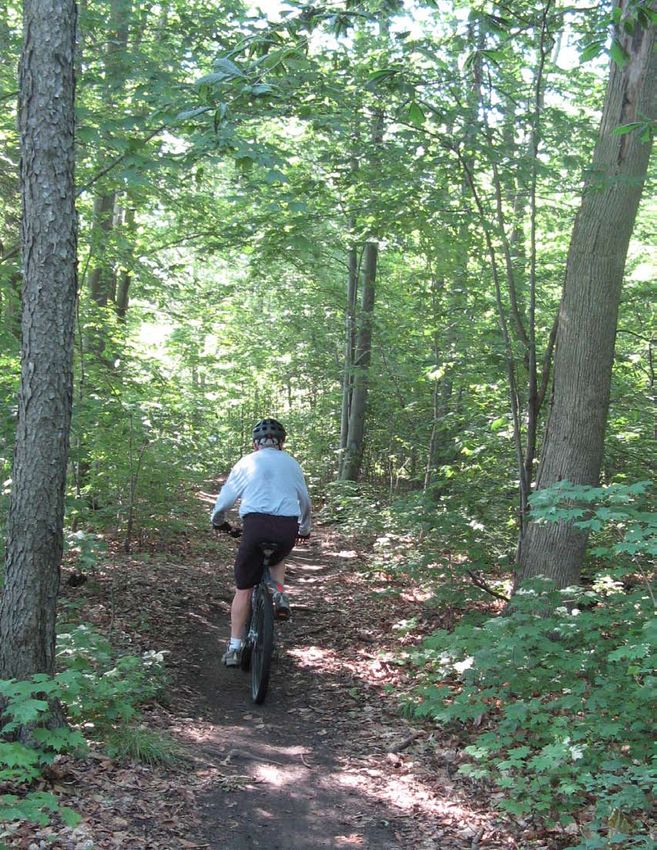
ISBN 1-894329-12-0

Upper Thames River Conservation Authority
1424 Clarke Road
London, Ontario N5V 5B9
Phone: 519-451-2800
Website: www.thamesriver.on.ca
E-mail: info@thamesriver.on.ca

Cover Photograph: The Thames CHRS plaque at the Forks in London. C. Quinlan

Photo Credits: C. Quinlan, M. Troughton, P. Donnelly
Thames River, Ontario

                          Canadian Heritage Rivers System,
                            Ten Year Monitoring Report
                                   2000 – 2012

Compiled by Cathy Quinlan, Upper Thames River Conservation Authority, with assistance from members
of the Thames Canadian Heritage River Committee.

Thanks are extended to the CHRS for the financial support to complete this ten year monitoring report.

Thanks to Andrea McNeil of Parks Canada and Jenny Fay of MNR for guidance and support.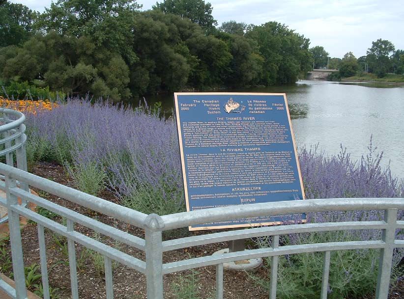
Chronological Events
Thames River 2000-2012
                         Natural Heritage Values

                         Cultural Heritage Values

                             Recreational Values

                              Integrity Guidelines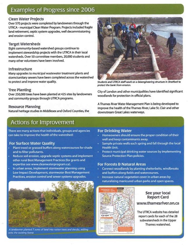
Executive Summary

Executive Summary
The Thames River nomination for inclusion in the Canadian Heritage Rivers System (CHRS) was
accepted by the CHRS Board in 1997. The nomination document was produced by the Thames River
Coordinating Committee, a volunteer group of individuals and agency representatives, supported by
the Upper Thames River Conservation Authority (UTRCA) and Lower Thames Valley Conservation
Authority (LTVCA).

The Thames River and its watershed were nominated on the basis of their significant human heritage
features and recreational values. Although the Thames River possesses an outstanding natural heritage
which contributes to its human heritage and recreational values, CHRS integrity guidelines precluded
nomination of the Thames based on natural heritage values because of the presence of impoundments.

Following the production of the extensive Background Study document in 1997 and the Thames Strategy
in 2000, the Thames was designated a Canadian Heritage River in the summer of 2000. The dedication
ceremony took place in September of 2000 in London, Ontario.

This report attempts to collect and analyse the events, studies and any improvements or threats to the river
and watershed for the 10 years after designation (2000 to 2012).

Many improvements have been made to the natural, cultural and recreational values as well as general
river awareness. Some noted examples from Chapters 2 (Chronology of Events since Designation),
3 (Natural Heritage Values since Designation), 4 (Cultural Heritage Values since Designation), and 5
(Recreational Values since Designation) of this report include:

    • The annual Thames River Cleanup, started in 2000, has grown each year,
    • The Upper Thames River Conservation Authority has produced three sets of watershed report
       cards (2001, 2007, 2012), synthesizing a great deal of environmental data in a concise format,
       showing steady to improving conditions,
    • New riverside trails have been opened on the North Thames and South Thames as well as in
       communities such as St. Marys, Ingersoll and London,
    • The historic Thames River Lighthouse received a face lift in 2002,
    • Several books have been written on the Thames dealing with local history, art and the War of
       1812,
    • Bridge signs at several Thames River crossings have been erected to raise awareness about the
       river and its CHRS designation,
    • War of 1812 commemorative events were launched,
    • Living History events and re-enactments continue across the watershed,
    • The London Free Press ran a 5 month series called A River covering a wide range of Thames
       River related articles, videos, blogs, photos, etc.,
    • Several museums have improved their infrastructure and programming,
    • In 2009, London City Council adopted the Thames Valley Corridor Plan, Phase 2 (2009) a
       long-range vision document that will be a key planning tool for sustaining the river’s attributes,
       supporting environmental and economic vitality, tourism and local and regional recreation

                                                     I    Thames River CHRS 10 Year Monitoring Report 2000-2012
Executive Summary

        initiatives. Also the plan requires appropriate integration of new buildings into the corridor
        environment rather than ‘turning their back’ on the corridor,
    • In 2010/11, an updated Thames River Water Management Plan (TRWMP) was initiated. This
       plan is a key component of a broader Watershed Strategy known as the Thames River Clearwater
       Revival,
    • The Conservation Authorities and many partner groups use the Canadian Heritage River logo or
       reference the CHRS status of the Thames in their correspondence and reports.
The analysis of Integrity Guidelines in Chapter 6 shows no threats to most values. The only threats are
wide ranging issues, such as climate change, that are not isolated to the Thames River, and whose impacts
are unknown at this time.

Chapter 7 (Management Plan Recommendations and Current Status) lists 12 objectives from the Thames
Strategy and reviews achievements or lack thereof. In summary, five objectives are complete, one is
addressed, three are ongoing, and three are partially complete.

Overall, the cultural and recreational values for which the Thames was designated remain intact. The
natural, cultural and recreational landscape through which the river flows continues to be enjoyed,
appreciated and celebrated by area residents and visitors.

Thames River CHRS 10 Year Monitoring Report 2000-2012   II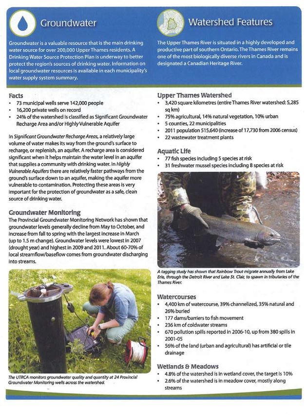
Table of Contents
Executive Summary..........................................................................................................................................i

Chapter 1. Introduction. ................................................................................................................................1
		                    1.1   Purpose............................................................................................................................1
		                    1.2   Background to Designation.............................................................................................1
		                    1.3   Overview of the Thames River Watershed......................................................................2
		                    1.4   Methodology....................................................................................................................3

Chapter 2. Chronology of Events since Designation......................................................................................5
                  Year 2000 to 2012.......................................................................................................................5

Chapter 3. Natural Heritage Values since Designation................................................................................13
  1.                 Hydrology.............................................................................................................................14
		                   1.1 Drainage Basins.............................................................................................................14
		                   1.2 Seasonal Variation.........................................................................................................14
		                   1.3 Water Content................................................................................................................14
		                   1.4 River Size......................................................................................................................14
  2.                 Physiography........................................................................................................................14
		                   2.1 Physiographic Regions..................................................................................................14
		                   2.2 Geological Processes.....................................................................................................15
		                   2.3 Hydrogeology................................................................................................................15
		                   2.4 Topography....................................................................................................................16
  3.                 River Morphology.................................................................................................................16
		                   3.1 Valley Types...................................................................................................................16
		                   3.2 Channel Types...............................................................................................................17
		                   3.3 Channel Profile..............................................................................................................18
		                   3.4 Fluvial Landforms.........................................................................................................19
  4.                 Biotic Environments.............................................................................................................20
		                   4.1 Aquatic Ecosystems.......................................................................................................20
		                   4.2 Terrestrial Ecosystems...................................................................................................21
  5.                 Vegetation.............................................................................................................................22
		                   5.1 Significant Plant Communities......................................................................................22
		                   5.2 Rare Plant Species.........................................................................................................23
  6.                 Fauna.....................................................................................................................................24
		                   6.1 Significant Animal Populations.....................................................................................24
		                   6.2 Rare Animal Species......................................................................................................25

Chapter 4. Cultural Heritage Values since Designation. ..............................................................................27
  1.                  Resource Harvesting.............................................................................................................28
		                    1.1 Fishing...........................................................................................................................28
		                    1.2 Shoreline Resource Harvesting.....................................................................................29
		                    1.3 Extraction of Water........................................................................................................29

                                                                              III    Thames River CHRS 10 Year Monitoring Report 2000-2012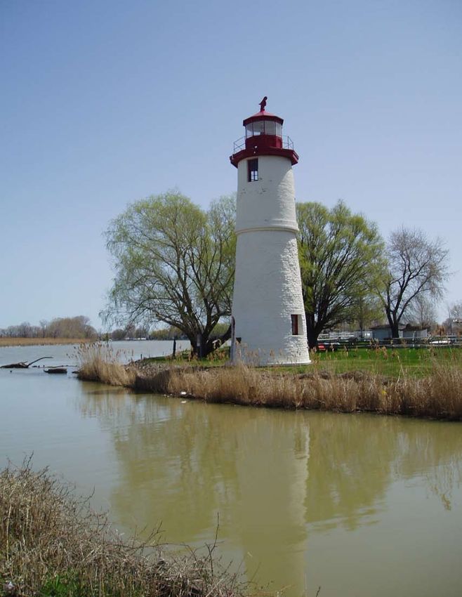
Table of Contents
  2.               Water Transport.....................................................................................................................30
		                 2.1 Commercial Transportation...........................................................................................30
		                 2.2 Transportation Services.................................................................................................30
		                 2.3 Exploration and Surveying............................................................................................30
  3.               Riparian Settlements.............................................................................................................31
		                 3.1 Siting of Dwellings........................................................................................................31
		                 3.2 River-based Communities.............................................................................................32
		                 3.3 River-influenced Transportation....................................................................................33
  4.               Culture and Recreation.........................................................................................................34
		                 4.1 Spiritual Associations....................................................................................................34
		                 4.2 Cultural Expression.......................................................................................................35
		                 4.3 Early Recreation............................................................................................................36
  5.               Jurisdictional Uses................................................................................................................37
		                 5.1 Conflict and Military Associations................................................................................37
		                 5.2 Boundaries.....................................................................................................................37
		                 5.3 Environmental Regulation.............................................................................................38

Chapter 5. Recreational Values since Designation......................................................................................41
  1.               Boating..................................................................................................................................42
		                 1.1 Whitewater Canoeing, Kayaking and Rafting...............................................................42
		                 1.2 Extended Canoe Tripping (motor and non-motor)........................................................42
		                 1.3 Day Paddling and Rowing.............................................................................................42
		                 1.4 High Speed Boating.......................................................................................................46
		                 1.5 Motorized Pleasure Cruising / Houseboats...................................................................43
		                 1.6 Commercial Tour Boats.................................................................................................43
  2.               Angling.................................................................................................................................44
		                 2.1 Day Angling...................................................................................................................44
		                 2.2 Weekend Angling...........................................................................................................44
		                 2.3 Extended Angling Vacations..........................................................................................44
		                 2.4 Fly Fishing.....................................................................................................................44
		                 2.5 Ice Fishing.....................................................................................................................45
		                 2.6 Specific Fish Species.....................................................................................................45
  3.               Water Contact / Content........................................................................................................46
		                 3.1 Swimming......................................................................................................................46
		                 3.2 Water Skiing..................................................................................................................46
		                 3.3 Snorkel / Scuba..............................................................................................................46
  4.               Water-associated Activities...................................................................................................47
		                 4.1 Trail Use (hiking, walking, cycling)..............................................................................47
		                 4.2 Camping.........................................................................................................................47
		                 4.3 Hunting..........................................................................................................................47
  5.               Winter Activities...................................................................................................................48
		                 5.1 Snowmobiling / Dog Sledding......................................................................................48
		                 5.2 Cross-country Skiing.....................................................................................................48
		                 5.3 Skating...........................................................................................................................48

Thames River CHRS 10 Year Monitoring Report 2000-2012                      IV
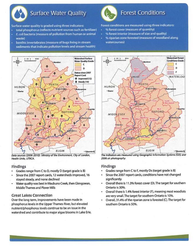
Table of Contents
  6.                 Natural Heritage Appreciation..............................................................................................49
		                   6.1 Wildlife..........................................................................................................................49
		                   6.2 Vegetation......................................................................................................................49
		                   6.3 Vistas / Scenic Quality...................................................................................................50
		                   6.4 Geological Features / Water Features............................................................................50
  7.                 Human Heritage Appreciation..............................................................................................51
		                   7.1 Historical Sites...............................................................................................................51
		                   7.2 Cultural Landscapes......................................................................................................52
		                   7.3 Sporting Events / Activities...........................................................................................53
		                   7.4 Cultural Events / Activities............................................................................................53

Chapter 6. Integrity Guidelines since Designation........................................................................................55
                 1. Natural Integrity Guidelines.................................................................................................56
                 2. Cultural Integrity Guidelines................................................................................................58
                 3. Recreational Integrity Guidelines.........................................................................................60

Chapter 7. Management Plan Recommendations and Current Status.......................................................63

Chapter 8. Conclusions and Recommendations.........................................................................................67

List of Tables
                 Table 1. Natural Heritage Values since Designation.................................................................14
                 Table 2. Cultural Heritage Values since Designation................................................................28
                 Table 3. Recreational Values since Designation........................................................................42
                 Table 4. Integrity Guidelines since Designation.......................................................................56
                 Table 5. Management Plan Recommendations and Current Status...........................................63

List of Figures
                 Figure 1. The Thames River Watershed......................................................................................4

Selected References.....................................................................................................................................68

Appendix
                 Upper Thames River 2012 Watershed Report Card Summary.................................................69
                 LTVCA Watershed Report Card Summary...............................................................................73

                                                                            V      Thames River CHRS 10 Year Monitoring Report 2000-2012
Chapter 1: Introduction

Chapter 1. Introduction
1.1 Purpose

This report is a 10 year monitoring requirement to assess the status of the values identified in the
Nomination Document and the management actions in The Thames Strategy (Management Strategy
document).

The objectives of this report are to:
    • Describe major changes and/or events on or of the River since 2000,
    • Report on the current condition of heritage values for which the River was nominated and whether
       the River still possesses these values,
    • Review CHRS integrity guidelines to determine if they are still being met,
    • Determine the degree to which actions outlined in the Heritage Strategy have been implemented,
    • Describe any threats to values or to integrity guidelines since nomination, and
    • Make recommendations.

1.2 Background to Designation

In 1996, a broad-based community group of more than 70 people, representing many different local
organizations and with support from all municipalities in the watershed, began to gather information
and prepare the necessary documents for the nomination of the Thames as a Canadian Heritage River.
Coordinated by a Steering Committee led by Dr. Douglas Bocking, retired Dean of Medicine at Western
University, and with technical assistance from the Upper Thames River Conservation Authority
(UTRCA), a request for consideration of the Thames watershed was made.

The committee and UTRCA staff prepared the Nomination Document in 1997, which was accepted by
the Canadian Heritage Rivers Board. In 1997, following successful fundraising, researchers were hired to
prepare the extensive Background Study document and Management Strategy, under the guidance of the
Steering Committee and others.

The entire length of the Thames River was designated a Canadian Heritage River in the fall of 2000 by
the governments of Ontario and Canada under the Canadian Heritage Rivers System (CHRS). The CHRS
is a national heritage program, a cooperative effort by the federal, provincial and territorial governments.

In the 10 or more years following designation, many positive changes have occurred and the Thames
continues to exemplify the outstanding cultural and recreational values for which it was nominated and
designated.

The Thames Canadian Heritage River Committee, supported and guided by the Upper Thames River
Conservation Authority (UTRCA) and Lower Thames Valley Conservation Authority (LTVCA),
continued to meet regularly after designation, to find ways to increase awareness about the value and
importance of the river. Other groups and agencies continue to promote and care for the river and
watershed.

                                                     1    Thames River CHRS 10 Year Monitoring Report 2000-2012
Chapter 1: Introduction
The Thames lies in a highly developed part of Ontario, outside of the provincial or federal park systems
(see Figure 1). Managing the Thames as a Canadian Heritage River involves nurturing the values for
which it was designated, with the following broad goal:
To increase the appreciation, enjoyment and stewardship of the natural and cultural
heritage and recreational opportunities of the Thames River and its watershed through
community cooperation and involvement.
A summary of the proposed Future Actions listed in The Thames Strategy include the following:
1. Establish and empower a Thames Implementation Committee to act as the catalyst that drives
The Thames Strategy.
2. Monitor the river’s values by completing the Thames River Annual Report Checklist; and
monitor the progress of The Thames Strategy every 10 years and present the results to the
Canadian Heritage Rivers Board.
3. Host a series of community workshops across the watershed inviting both non-government and
government stakeholders and individuals.
4. Promote and distribute the Thames River Background Study (print and CD ROM) to schools,
libraries and other interested groups.
5. Write and distribute a regular Thames River Newsletter.
6. Establish a Thames River website to communicate information.
7. Feature a regular column on the Thames in local newspapers.
8. Establish and celebrate an annual Thames River Heritage Day.
9. Erect plaques in communities explaining the designation of the Thames as a Canadian Heritage
River.
10. Develop Thames River Heritage Tours.
11. Produce a War of 1812 Daybook and/or Tour and erect signage at battlefield sites.
1.3 Overview of the Thames River Watershed
The Thames River watershed is nestled in the agricultural heartland of southwestern Ontario in close
proximity to lakes Huron, St. Clair, and Erie. The river is 273 km long (as measured from the headwaters
of the South Thames) and drains some 5,825 km2 of land, making it the second largest watershed in
southwestern Ontario. Figure 1 illustrates the major drainage pattern of the watershed and the locale of
major urban centres.
The Thames rises at three distinct points. The South Thames or South Branch originates near Tavistock,
and flows through Woodstock, Ingersoll and London, where it is joined by the North Thames. The North
Thames River, also known as the North Branch, begins near Mitchell and flows through St. Marys to the
Forks. The Middle Thames River starts near Hickson and enters the South Thames near Putnam. The
Forks in London is the city’s most important historical landmark. From this point, the river flows parallel
to Lake Erie toward Lake St. Clair, passing through Delaware, Wardsville, Thamesville and Chatham as
well as the Chippewa, Oneida, Munsee-Delaware and Moravian Delaware First Nations communities.
The Thames empties into Lake St. Clair at Lighthouse Cove.
Thames River CHRS 10 Year Monitoring Report 2000-2012 2Chapter 1: Introduction
There are approximately 550,000 people living in the watershed. The river is under the jurisdiction of two
conservation authorities: The Upper Thames River and Lower Thames Valley, with the dividing line at
Delaware downstream of London.
The presence of dams on the river precluded its designation on natural values. However, the location of
the Thames within the ecologically rich Carolinian Zone (Deciduous Forest Region) means it has a large
diversity of plants and animals and also a large number of species at risk. These features are described
in the Background Study: Thames River Watershed, Ontario (1997) and summarized in The Thames
Strategy: Managing the Thames as a Canadian Heritage River (2000).
The Thames was known historically as Askunesippii or Antlered River by the Ojibway people, and later
as La Tranche or The Trench by French fur traders, and finally as the Thames River by Governor Simcoe
(circa 1784), after the Thames River in London, England.
1.4 Methodology
The following approaches were used to gather information towards assessing the river’s status as a
Canadian Heritage River in the ten years following designation:
• Review of the Background Study (1997), Nomination Document (1997) and Management Strategy
called The Thames Strategy (2000),
• Review of annual reports submitted to CHRS,
• Review of newsletters called Thames River Happenings prepared by the Thames Canadian
Heritage River Committee,
• Interviews with key personnel with an interest in the river,
• Review of various literature, media sources, and websites having relevance to the river and
watershed,
• Gathering and digesting of all the information received.
Tables provided by CHRS for Natural, Cultural and Recreational values as well as Integrity Guidelines
were used to document the river’s condition in a concise and complete manner.
Some of the members of the Thames Canadian Heritage River Committee with
the CHRS plaque at the Forks in London.
3 Thames River CHRS 10 Year Monitoring Report 2000-2012Chapter 1: Introduction
Figure 1. The Thames River Watershed
Goderich
WELLINGTON
YUKON
TERRITORY HURON
NORTHWEST
TERRITORIES NUNAVUT
BRITISH CANADA NEWFOUNDLAND and
COLUMBIA LABRADOR
EW AN
WATERLOO
ALBERTA
MANITOBA
ATCH
K
IC
Mitchell
SASK
QUEBEC
SW
ONTARIO P.E.I.
B R EW
UN
N
NOVA
SCOTIA
UNITED PERTH
STATES
r Stratford
General area of the Exeter Rive
Avon
1,000 500 0 1,000 km Thames River watershed
Grand Bend Tavistock
Lake Huron St. Marys
r
s Rive
Ipperwash
r
Rive
Thame
es
am
r
ve
Th
Ri
Woodstock
North
MIDDLESEX
es
dle
am
Mid
Th
h
ut
Ingersoll
So
Sarnia
MICHIGAN OXFORD
Strathroy
Tillsonburg
er
LAMBTON
St. Clair Riv
K
St.Thomas
OL
RF
ELGIN
NO
Dutton
Wallaceburg
er
s Riv WELLINGTON
ame
Th
Lake Ridgetown Lake Huron HURON WATERLOO
St. Clair Chatham PERTH
CHATHAM-KENT
Lighthouse Cove Lake Erie Michigan OXFORD
MIDDLESEX
ir River
LAMBTON
LK
Legend
St. Cla
O
ELGIN RF
NO
Municipal Boundaries
Wheatley
ESSEX Lake
CHATHAM-KENT
r
First Nation Reserves St. Clair
sR
ive
iver
Leamington me
Tha
oit R
Thames River Watershed
Detr
ESSEX
Lake Erie
25 12.5 0 25 km
Thames River CHRS 10 Year Monitoring Report 2000-2012 4Chapter 2: Chronology of Events
Chapter 2. C
hronology of Events
since Designation
The following section summarizes some of the key events, actions, research or studies that have occurred
since designation in the year 2000 to present (2012). Many activities have been initiated by the Thames
Canadian Heritage River Committee, the Upper Thames River Conservation Authority (UTRCA), and
Lower Thames Valley Conservation Authority (LTVCA). However, an equally large number of events
have been initiated by local citizens, communities and municipalities, each dedicated to sustaining the
Thames River’s values.
2000
• The Thames River and its watershed were officially designated to the Canadian Heritage Rivers
System (CHRS). The designation event was held on September 29th next to the North Thames
River in Gibbons Park, London, Ontario.
• The first annual Thames River Cleanup was started by Perth County resident, Todd Sleeper.
• A bronze plaque recognizing the historic significance of the Thames River and its CHRS
designation was unveiled at Thamesgrove Conservation Area in Chatham on September 30th
during the Heritage Days weekend. The Heritage Days Committee, with support of the Kent
Military Re-enactment Society and Kent Historical Society, organized the erection of the plaque
and the unveiling ceremony.
2001
• The Thames Canadian Heritage River Committee hosted the first Thames River Symposium, titled
“Canadian Heritage Rivers Designation: Where do we go from here?” The one-day event took
place on April 7th, 2001 at King’s College, London, Ontario.
• The Upper Thames River Conservation Authority published its first set of Watershed Report
Cards, giving grades for surface water quality and forest conditions for 28 subwatersheds within
the basin. The average surface water quality grade was a C and the average forest conditions grade
was a D. This report provided a benchmark for future report cards. It was the first watershed report
card in Ontario that focused on environmental indicators and compiled a great deal of scientific
data into one, concise, readable, document.
• Twenty-eight artists celebrated the designation of the Thames as a Canadian Heritage River (CHR)
with paintings, quilts, fibre arts, photography and pottery. The show was called “River: A View of
the Thames” and was held July 8-29 at the Ingersoll Creative Arts Centre.
• The Clean Water Project was launched in 2001. This tri-county program provided grants and
technical advice to farmers and rural landowners in Oxford, Middlesex and Perth counties (most
of the Upper Thames Watershed) to implement Best Management Practices around the farm such
as soil erosion control and septic system repairs. Hundreds of projects were completed in the first
year of the program.
5 Thames River CHRS 10 Year Monitoring Report 2000-2012Chapter 2: Chronology of Events
2002
• The Thames Canadian Heritage River Committee hosted the 2nd annual Thames River
Symposium, titled “Focus on the Thames,” on March 28th at the St. Marys Town Hall, St. Marys,
Ontario.
• The new North Thames Walking Trail was completed, extending from Mitchell to Motherwell
(14 km), the first trail in this region.
• The Thames Canadian Heritage River Committee published the first edition of the Thames River
Happenings newsletter.
• The historic Thames Lighthouse received a much needed face lift, with funds raised locally in
Lighthouse Cove, and overseen by the Lower Thames Valley Conservation Authority.
• The Middlesex Stewardship Committee and Resources Improvement Oxford improved river
access at several locations in the watershed including Delaware, Woodstock and Wardsville. Signs
thanking supporters and recognizing the Thames designation were installed.
• The Thames Talbot Land Trust acquired its first property, a 6 ha property along the South Thames
in London, called Meadowlily Nature Preserve.
• Glenn Stott, member of the Thames Canadian Heritage River Committee, published Greater
Evils: The War of 1812 in Southwestern Ontario. It provides an account of the events of the war in
London and Western Districts of Upper Canada.
2003
• The Thames Canadian Heritage River Committee hosted the 3rd annual Thames River Symposium
on March 28th at the Chatham Cultural Centre, Chatham, Ontario.
• The Thames Canadian Heritage River Plaque was installed at the Forks of the Thames in
downtown London. A grant from the London Community Foundation was used to build a special
stand for the bronze plaque, with in-kind donations from the City of London for the design and
installation. Installation was delayed until major upgrades to the park system were completed.
• The State of the Thames River Workshop was held on Sept. 16th and 17th at Club Lentina’s in
Chatham, Ontario. It was supported by the Lake Erie Lakewide Management Plan initiative and
hosted by Environment Canada, Fisheries and Oceans Canada, Ontario Ministry of Agriculture
and Food, Ontario Ministry of the Environment, Ontario Ministry of Natural Resources, Lower
Thames Valley and Upper Thames River Conservation Authorities.
• The Thames Canadian Heritage River Committee published the Thames River Happenings
newsletter, Volume 4.
• Richard Bain published a book of photographs called The Thames, A Pictorial Journey, with a
launch at Museum London on April 26th.
• Zebra mussels were found for the first time in the Thames River.
• The Middlesex Natural Heritage Study was completed by the Upper Thames River Conservation
Authority and County of Middlesex. The study identified significant woodlands at the county level
for protection in the Official Plan.
Thames River CHRS 10 Year Monitoring Report 2000-2012 6Chapter 2: Chronology of Events
2004
• The Thames Canadian Heritage River Committee hosted the 4th annual Thames River Symposium
on March 26th at Goff Hall, Woodstock, Ontario.
• Volume 5 of the Thames River Happenings newsletter was published.
• Longwoods Road Conservation Area hosted River Day walks in June.
• Fisheries biologists from the UTRCA discovered small populations of Northern Brook Lamprey in
a tributary of the Thames near London. This non-parasitic species had not been seen since 1931.
• The Recovery Strategy for the Thames River Aquatic Ecosystem was completed in 2004, led by
the Upper Thames River Conservation Authority. This strategy identified key threats and actions
needed to recover aquatic species at risk.
• A patch of Blue Ash trees was discovered on the banks of the Thames near London, the most
northerly record in Canada.
• Dr. Michael Troughton of the Geography Department at the University of Western Ontario
completed a database of more than 12,000 historic (pre-1914) commercial and institutional
buildings in the Thames and surrounding watersheds.
2005
• The Thames Canadian Heritage River Committee hosted the 5th annual Thames River Symposium
on April 15th at the Stratford Kiwanis Community Centre, Stratford, Ontario.
• On April 22nd (Earth Day), over 1,000 people participated in the 6th Annual Thames River Cleanup.
• The Thames Talbot Land Trust secured its first conservation easement of the Eberhardt property, a
combination organic farm and wooded property north of Stratford in the headwaters of the Thames
River.
• On March 6th, the Royal Scots re-enactors marched from Strathburn to Battle Creek to hold a
memorial service for those who died at Battle Hill on March 6, 1814.
• The Thames Canadian Heritage River Committee published Volume 6 of the Thames River
Happenings newsletter.
• Two small weirs were removed from tributaries of the Thames to improve water quality and fish
migration. The project was led by the UTRCA.
• The Town of Ingersoll created a new walking trail linking the Cheese Factory Museum and the
Sports Hall of Fame to other trails along the South Thames River.
2006
• The Thames Canadian Heritage River Committee hosted the 6th annual Thames River Symposium
on April 1st at Glencoe Presbyterian Church, Glencoe, Ontario. This was a workshop on Exploring
the Heritage of the Thames Valley through its Arts and Culture. It brought together artists and
historians from across the watershed.
• In December, the Thames Canadian Heritage River Committee and Community Heritage Ontario
co-sponsored a Cultural Heritage Landscape workshop in St. Marys.
7 Thames River CHRS 10 Year Monitoring Report 2000-2012Chapter 2: Chronology of Events
• Approximately 140,000 trees and shrubs were planted across the watershed by the Upper Thames
River and Lower Thames Valley Conservation Authorities in 2006.
• The long-running Faire at the Forks in Chatham hosted its final event in the fall of 2006. Also
known as Heritage Days, this weekend re-enactment of the War of 1812 and voyageur life was a
huge success for many years.
• The Oxford Natural Heritage Study was completed by the County of Oxford and the UTRCA. The
study used landscape scale analysis to identify significant woodlands for designation (protection)
in the official plan.
2007
• The Thames Canadian Heritage River Committee hosted the 7th annual Thames River Symposium
on April 14th at Ursuline College High School in Chatham.
• The Upper Thames River Conservation Authority published its second set of Watershed
Report Cards, tracking changes in environmental conditions since the 2001 report cards. Some
improvements were seen in surface water quality and new information on groundwater conditions
was added.
• The North Thames River Canoe Route brochure was updated by the UTRCA and posted online for
the first time.
• A group of London artists and supporters paddled down the river, recreating a journey taken a
century earlier by renowned artist Paul Peel and others, from the Forks of the Thames to the mouth
at Lake St. Clair. The artists connected with numerous communities along the way including First
Nations communities. Their journey, artwork and what they learned was shared with many groups
throughout the watershed in the months and years following.
• The West Perth Thames Nature Trail and Wetlands opened to the public. This 5 km trail along the
top end of the North Thames River near Mitchell provided a much needed river experience.
• Chatham historian Jim Gilbert published Looking Back, The Thames River, Ontario. The book
contains many wonderful historical photos from personal collections throughout the watershed as
well as current views.
2008
• The London Free Press ran a 5 month series called A River covering a wide range of Thames
River-related articles, videos, blogs, photos, etc. Editor Paul Berton wrote “It’s not traditional
journalism or breaking news about death, destruction, crime celebrity, sex or corruption. But it is
education and story-telling, and it’s all about our community.”
• The Thames Canadian Heritage River Committee published the last issue of the newsletter
Thames River Happenings in the spring of 2008.
• In May, artist and teacher Kevin Bice and a group of 18 other artists launched The River Project, a
book that illustrates their collective works (the artists had initiated this project two years earlier).
The well-received book sold out quickly and the art toured several local galleries.
• The historic Springbank Dam in London was retrofitted, but an important mechanism broke when
tested the first time, leaving it inoperable for an indeterminate amount of time.
Thames River CHRS 10 Year Monitoring Report 2000-2012 8Chapter 2: Chronology of Events
2009
• A 168-page, full-colour guidebook, The Thames River Watershed: A Heritage Landscape Guide
by Michael Troughton and Cathy Quinlan was published and launched in June. Some 500 copies
were donated to watershed schools and libraries thanks to a grant from the Ontario Trillium
Foundation. Numerous copies were sold locally. The pocket-sized book was popular with history
buffs, geographers, students, and local residents. Sadly, the main author, Michael Troughton, died
in 2007 before it was published.
• The annual Thames River Cleanup, a community volunteer program, celebrated its 10th year
in 2009. The event, initiated by Perth County resident Todd Sleeper, had grown to numerous
communities in the watershed, with over 1,000 people participating each year.
• City of London council approved the Thames Valley Corridor Plan, Phase 2, a long-range vision
document and planning tool for sustaining the river’s attributes, supporting environmental and
economic vitality, tourism and local and regional recreation initiatives.
2010
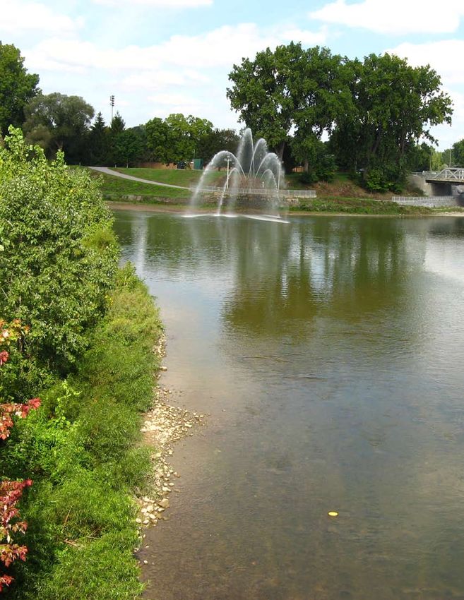
• A water fountain called the “jet d’eau” was installed at the Forks of the Thames in London as
an additional attraction to this important site. It was funded, in part, by a donation from local
philanthropist Martha Blackburn.
• The Thames Canadian Heritage River Committee’s ongoing project to erect bridge signs across
the watershed stating THAMES RIVER – A Canadian Heritage River was finally launched in
2010. Signs were installed at nine river crossings in the municipality of Chatham-Kent, the most
southerly of the counties in the Thames watershed, with financial support from the Lower Thames
Valley Conservation Foundation and local municipalities.
• The Karen Schuessler Singers, a classical choir based in London, presented a show called River:
Reflections on the Thames in May. The performance featured river-related songs.
• Wardsville, a small town on the lower Thames River, celebrated its Bicentennial in June and
featured a quilt depicting the life of founder George Ward and others of that era, including many
river-related blocks.
• A 25 km foot/mountain bike trail around Wildwood Reservoir in Wildwood Conservation Area
near St. Marys was opened to the public.
• The Longwoods Road Conservation Area launched its Carey Carolinian Arboretum trail, an
interpretive trail through a lovely Carolinian deciduous forest.
2011
• The City of London, UTRCA and other municipalities initiated a project called “The Thames
River Clearwater Revival” to focus on water quality and quantity issues. An updated Thames
River Water Management Plan was also initiated as part of the Revival.
• Three Thames River bridge signs were erected at three river crossings in the municipality of
Dutton-Dunwich in Middlesex County.
• The Clean Water Project, administered by the UTRCA and funded by the municipalities, continued
to fund hundreds of projects on farms in the Upper Thames watershed to protect surface and
groundwater.
9 Thames River CHRS 10 Year Monitoring Report 2000-2012Chapter 2: Chronology of Events
• In September, Doors Open London showcased many historical properties in and around the
Thames River including the Coves and Museum London at the Forks. Doors Open Oxford has
similar events.
• The Lower Thames Valley Conservation Authority celebrated its 50th Anniversary – 50 Years
of Conservation – with events held in municipalities and conservation areas throughout the
watershed. Many events highlighted the Thames as a Canadian Heritage River.
2012
• The Thames Talbot Land Trust acquired its 11th property, a woodland site near Wardsville, a short
distance from the Thames River. This property was the third secured parcel in the area known as
Skunk’s Misery, the most significant cluster of Carolinian woods in the Thames watershed.
• The UTRCA released its third set of Watershed Report Cards for 28 watersheds in the Upper
Thames. Surface water quality conditions remained steady in 16 watersheds and improved in 12,
compared with results five years earlier. Forest conditions also remained steady.
• The Longwoods Road Barn Quilt Trail was officially launched in 2012. This series of painted
blocks from quilts, made by local volunteers and students, were mounted on barns and buildings
along the 65 km section of Longwoods Road from the Tecumseh Monument near Thamesville
to Delaware. The barn quilt project depicts sections of quilts illustrating how the War of 1812
impacted the lives of women and children.
• Approximately 90,000 trees and shrubs were planted through conservation authority forestry
programs in 2012.
The Thames Happenings Newsletter and various The Thames Heritage Landscape Guide by Dr. Michael
published books on the Thames. Troughton and Cathy Quinlan was published in 2009.
Thames River CHRS 10 Year Monitoring Report 2000-2012 10Chapter 2: Chronology of Events
River cleanup days removes large volumes of garbage from
the Thames each year.
Thames River Symposium 2004 in Woodstock.
Thames River Symposium 2003 walking tour in Chatham.
Thames River Bridge sign in Thamesville, Chatham-Kent.
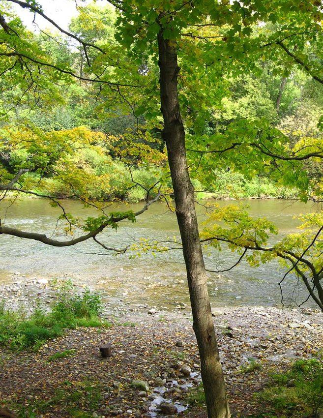
11 Thames River CHRS 10 Year Monitoring Report 2000-2012Chapter 3: Natural Heritage
Chapter 3. N
atural Heritage Values
since Designation
The Thames River was not nominated on its natural heritage values because of the presence of dams on
the river system. However, the river and its watershed do possess an outstanding natural heritage that
contributes to both its human heritage and recreational values. It is the natural heritage of the watershed
that has supported the evolution of human heritage and recreational values.
The Thames watershed, with its temperate climate, highly productive soils, and abundant water supply,
has attracted human habitation for over 10,000 years. The Thames was one of the first rivers formed
following the retreat of the last glacier in Ontario. The upper branches of the river still flow through the
ancient spillways. The lower river flows through flat plains of clay and sand, the result of thousands of
years under glacial lakes.
The Thames River is the only major river in Canada located almost entirely within the Carolinian Life
Zone, one of the most biologically productive eco-regions in Canada. The watershed provides habitat
for several rare and endangered species of flora and fauna as well as one of the most diverse fish and
freshwater mussel communities in Canada, resulting in outstanding opportunities for nature and scientific
appreciation.
Changes over the last decade have been positive for river water quality. Watershed Report Cards produced
by the Upper Thames River Conservation Authority have shown improvements in key indicators in
many subwatersheds, despite continued population growth in the basin. These improvements can be
attributed to ongoing rural stewardship programs, tree planting and naturalization projects, environmental
regulations, and waste water treatment upgrades.
The table that follows provides additional detail on the condition of the river and the actions and changes
that have taken place since 2000.
13 Thames River CHRS 10 Year Monitoring Report 2000-2012Chapter 3: Natural Heritage
Table 1: Natural Heritage Values since Designation
CHRS Natural Natural Heritage Significant Actions, Changes or Threats to
Framework Elements Description Research or Studies Nomination Value(s)
(2001) Themes
& Sub-themes
1. HYDROLOGY
1.1 Drainage The Thames watershed is Lake-wide Management None
Basins part of the Lake St. Clair/ Plans (LaMP) are
Lake Erie basin(s). underway for Lakes
St. Clair and Erie, led by
Environment Canada,
and the UTRCA is
participating.
1.2 Seasonal The river tends to carry The UTRCA added Climate change is
Variation its largest flows in March additional flow and predicted to bring more
and April (spring freshet) weather stations to the extreme weather to the
and lowest flows in watershed, as well as Great Lakes basin (more
July and August when radar technology, to floods any time of year,
evapo-transpiration, and provide better and quicker hotter summers, less
evaporation are highest. weather and stream flow snow and thus reduced
Monthly precipitation is information. spring freshets). The
fairly uniform, at 60- Western University lack of heavy spring
90 mm per month, with professor Slobodan flows may have negative
about 1 m of precipitation Simonovic of the Institute consequences on aquatic
annually. for Catastrophic Loss life that rely on the
Reduction has been scouring action of ice and
working on climate change water to maintain a healthy
models for the Thames stream bed.
region for several years.
1.3 W
ater Water quality ranges from Watershed Report Cards Overall, water quality
Content fair to poor based on released in 2001, 2007 and has remained steady,
three indicators: E. coli, 2012 by the Upper Thames despite a population
phosphorus, benthic River Conservation increase. Water quality
organisms. Conservation Authority (UTRCA) in some subwatersheds
Authorities have consolidate, interpret and has improved over the
ongoing water quality report conditions in a last decade as a result
monitoring stations, most concise and understandable of stewardship work,
in conjunction with the format for the public and waste water treatment
Ministry of Environment other agencies. It is now improvements, regulations,
(i.e., the Provincial Water easier to detect and report etc.
Quality Monitoring changes over time. The
Network). Lower Thames Valley
Conservation Authority
(LTVCA) will be releasing
its first set of watershed
report cards in 2013.
Thames River CHRS 10 Year Monitoring Report 2000-2012 14Chapter 3: Natural Heritage
CHRS Natural Natural Heritage Significant Actions, Changes or Threats to
Framework Elements Description Research or Studies Nomination Value(s)
(2001) Themes
& Sub-themes
1. HYDROLOGY
1.4 River Size The Thames is the Additional flow monitoring None
second largest river in stations have been added to
southwestern Ontario, the system over the last 10
but small in Canadian years by the UTRCA with
terms. At Thamesville support from the Ministry
(60 km from the mouth), of Natural Resources
discharges vary from 20 (MNR), to monitor high
cubic metres per second and low flow conditions.
(cms) in summer to 140
cms in March.
2. PHYSIOGRAPHY
2.1 Physio- The upper basin is made None None
graphic up of silt and clay tills
Regions (Stratford and Oxford Till
Plains), broken by several
terminal moraines. The
lower basin contains sand
and gravel deposits formed
under glacial lakes. Farther
downstream are the tills of
the St. Clair Clay Plain.
2.2 Geological The ancient granitic Active quarries exist at None
Processes Precambrian bedrock Beachville on the South
of the Canadian Shield Thames and St. Marys
is buried under 1500 m on the North Thames.
of younger sedimentary Heritage buildings in parts
bedrock and another 30 m of the watershed owe their
of overburden (till). The charm to the use of local
sedimentary bedrock is limestone.
from the Upper and Middle
Devonian Periods (black
shale, grey shale and
sandstone, and limestone).
The Thames is not
effective at illustrating
geological phenomena
due to the great depth of
the bedrock and the gentle
nature of the landscape.
Glacial rebound is
negligible.
15 Thames River CHRS 10 Year Monitoring Report 2000-2012Chapter 3: Natural Heritage
CHRS Natural Natural Heritage Significant Actions, Changes or Threats to
Framework Elements Description Research or Studies Nomination Value(s)
(2001) Themes
& Sub-themes
2. PHYSIOGRAPHY
2.3 Hydro- There was limited Significant work has None
geology understanding of local been completed on
groundwater levels, quality understanding local
and movement until the groundwater and drinking
Source Water Protection water resources through
program began in 2000, the Source Water
following the Walkerton Protection planning
water contamination process undertaken by
disaster. conservation authorities
under the Ministry of
Environment. Significant
Groundwater Recharge
Areas and Highly
Vulnerable Aquifers have
been mapped. In 2013 a
Source Protection Plan will
be completed.
Water budget modelling
has shown that about 60-
70% of local streamflow
comes from groundwater
discharging into streams.
2.4 T
opo- The topography is flat to None None
graphy rolling in upper watershed,
flat in lower watershed.
3. RIVER MORPHOLOGY
3.1 Valley The Thames is a fluvial The 2012/13 update to None
Types river valley, slightly the Middlesex Natural
entrenched in a gentle Heritage Study will
landscape made up of incorporate Significant
glacial till and clay and Valley Lands using
sand plains. Digital Elevation Model
Above the Forks, the technology to map the
branches of the Thames valleys.
occupy former glacial
spillways. Below the
Forks, the Thames
occupies a small valley of
its own making, carved
through soft glacial lake
sediments.
Thames River CHRS 10 Year Monitoring Report 2000-2012 16Chapter 3: Natural Heritage
CHRS Natural Natural Heritage Significant Actions, Changes or Threats to
Framework Elements Description Research or Studies Nomination Value(s)
(2001) Themes
& Sub-themes
3. RIVER MORPHOLOGY
3.2 Channel The Thames River takes The main channels of the There continue to be
Types on several channel Thames have remained petitions to put natural
patterns, but overall is unchanged over the last watercourses (often
best described as having a decade, for the most part. intermittent streams) under
sinuous channel pattern or Smaller tributaries have the Drainage Act, where
irregular meanders. been altered over the they can be dredged,
decades in rural and urban straightened or buried. In
areas. urban areas, streams can be
The UTRCA has altered by stormwater pond
classified all open construction.
watercourses in the upper Education and
Thames and found: 39% stewardship work by the
have been channelized, conservation authorities
35% are natural (mainly attempt to mitigate these
the larger rivers and destructive practices. The
streams), and 26% are UTRCA has had some
buried. These statistics success in working with
have not changed much drainage superintendents
in 10 years. This data and consultants to bring
came from the Drain back natural meanders to
Classification Project that smaller drains that have
began in 1999 with support been channelized in the
from the Department of past.
Fisheries and Oceans,
combined with UTRCA
Geographic Information
Systems technology.
17 Thames River CHRS 10 Year Monitoring Report 2000-2012You can also read