The use of green in the redevelopment of industrial areas in Bilbao and Antwerp - Tjeu de Gouw 5405769 AR2A011 Architectural History Thesis TU ...
←
→
Page content transcription
If your browser does not render page correctly, please read the page content below
The use of green in the redevelopment of
 industrial areas in Bilbao and Antwerp

                      Tjeu de Gouw
                         5405769

           AR2A011 Architectural History Thesis
                        TU Delft
                       15-04-2021

                                                  1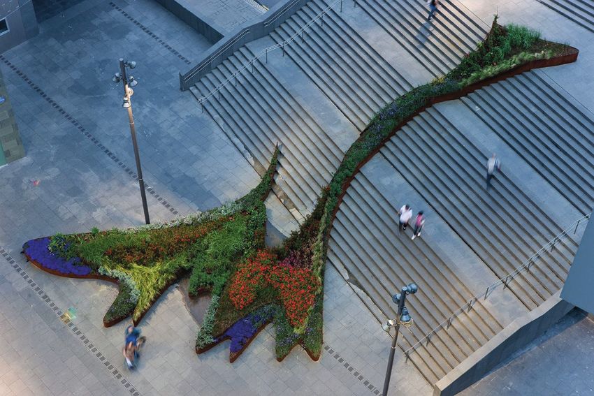
Abstract

The Guggenheim Museum in Bilbao had an important influence on the
economical growth of the city and the redevelopment of a industrial
area in the city, referred to as the Bilbao effect. Later, other cities tried
a similar approach in the redevelopment of city areas, of which the
redevelopment of het Eilandje in Antwerp is an example.

In literature the definitions provided for the term Bilbao effect often
focus on the Guggenheim museum, its aesthetics and influence of
the building. However, the museum was part of a larger masterplan to
redevelop Bilbao after a industrial decline.

This thesis will elaborate on the masterplans used to redevelop
the industrial areas in both Bilbao and Antwerp. While these
redevelopments handle former industrial areas with little green, the
focus will be on the implementation of greenery in the masterplans
and the contribution to the redevelopment.

Both primary and secondary sources are used to research this topic.
The primary research consists of an interview with Filip Smits, who
has been involved in the redevelopment for het Eilandje in Antwerp.
The secondary research consists of literature research on the
history, masterplans, green structure plans and key elements of the
redevelopment in Bilbao and Antwerp.

2
Content

    Introduction		                                                    4

1   The Bilbao Effect		                                               6

    1.1   The Guggenheim Museum			                                    6

    1.2   The Bilbao Effect and its influence		                        7

    1.3   Behind the Bilbao Effect		                                  8

    1.4   Conclusion				                                              8

2   The Redevelopment of Bilbao					                                  9

    2.1   The industrial decline of Bilbao			                         9

    2.2   The redevelopment of Bilbao			                              10

    2.3   The Abandoibarra Masterplan 		                              11

    2.4   The implementation of green in Abandoibarra		               13

    2.5   Conclusion							                                           16

3   The redevelopment of Antwerp		                                    17

    3.1   The Bilbao Effect in Antwerp							                         17

    3.2   History of het Eilandje							                              18

    3.3   Het Eilandje Masterplan			                                  19

    3.4   The implementation of green in het Eilandje Masterplan			   20

    3.5   Conclusion								                                          25

    Conclusion						                                                  27

    Bibliography										                                            28

    Illustration credits						                                        29

                                                                       3
Introduction

Since the Guggenheim Museum Bilbao(Image 0.01), designed by
Frank Gehry, opened in 1997, the city had a lot of benefit from the
museum, while the building attracted a lot of visitors and tourists and
contributed to the redevelopment of a former industrial area in the
harbor city. The economic boost for this city led to the so called ‘Bilbao
effect’, of which the Guggenheim Museum is seen as one of the main
features.

After the Bilbao effect, multiple cities tried a comparable approach to
                                                                             0.01
redevelop urban areas and create a similar kind of economic effect.          Guggenheim Museum
An example is the redevelopment of ‘het Eilandje’ in Antwerp, which          Bilbao, Frank Gehry,
is, similar to Bilbao, the redevelopment of an industrial area in a          1997

harbor city. The Museum aan de Stroom (MAS)(Image 0.02), designed            0.02
by Neutelings Riedijk Architecten is one of the main aspect in the           Museum aan de Stroom,
                                                                             Neutelings Riedijk
redevelopment of this former harbor area in Antwerp.                         Architecten, 2011

4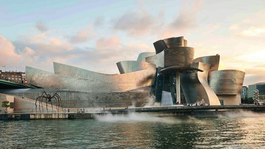
A lot of articles have been written about the Guggenheim museum
and the Bilbao effect, both on its architectural and economic influence.
Beatriz Plaza, who currently works at the Department of Public Policy
and Economic History at the University of the Basque Country in Bilbao,
wrote multiple articles about the Guggenheim, the influence of the
museum for Bilbao and the use of museums in the renewal of industrial
areas in European cities.

The comparison between the Guggenheim and MAS is made before
in the article ‘The museum after the ‘’Bilbao effect’’’ written by
Sanja Rodeš, who is currently a lecturer in architecture at School of
Architecture and Built Environment at Deakin University.
This and other articles about the Guggenheim and the MAS mainly
focus on the aesthetics of the buildings. While the masterplan for het
Eilandje is relatively new and still under construction, only few articles
are written about it yet.

The articles by Rodeš and Plaza state that the Bilbao effect is
generally defined as; “the use of a flagship building characterized
by iconic architecture and designed by a ‘star architect’ as a means
for the culture driven-revitalization of an rundown area”. However,
this definition does not include the fact that both the Guggenheim
museum and the Museum aan de Stroom were part of bigger
masterplans for the development of respectively the Abandoibarra
area in Bilbao and het Eilandje in Antwerp. These plans also included
the general improvement of these areas, the connection with the
inner cities, public transport and the implementation of other public
functions in the areas. In general, there is very little green in these
industrial areas and the implementation of green can be a considerable
part of the masterplans and thereby also have an influence on the
Bilbao effect. Therefore, it is worth investigation how greenery is
implemented in these masterplans, so the research question of this
dissertation is;

  “How did the harbor cities Bilbao and Antwerp add greenery in the
  redevelopment of their former industrial areas in the last 30 years?”

To answer this question, the development of the Abandoibarra area
in Bilbao and het Eilandje in Antwerp are investigated by looking into
the history and reasoning behind the development, the general visions
and key features of the masterplans, the green structure plans and the
result of the implementation of green in these areas.

First, the concept of the Bilbao effect is described as it is known
nowadays. Then this Bilbao effect is connected to the development
of the Abandoibarra area by looking into the context behind the
development, the vision and the most important elements for the
development and the implementation of green. The same steps are
investigated for the development of het Eilandje to compare the two
areas and conclude on the research question.

                                                                             5
1. The Bilbao Effect

The term ‘Bilbao effect’, also referred to as the ‘Guggenheim effect’, is
well known in the field of architecture and is immediately connected
with the Guggenheim museum in Bilbao designed by Frank Gehry. The
Bilbao effect refers to the benefits the museum provided for the city
of Bilbao. This chapter will addresses how the Bilbao effect originated,
the influence, and what the definitions of the effect in literature include
and neglect as a motive for the following chapters.

1.1.   The Guggenheim Museum

During the twentieth century, the perception on exhibitions changed
as a result of the experience with temporary exhibitions at the World
Fair of the nineteenth century. During this period the interest in so
called ‘loan exhibitions’ grow. With the loan exhibition it became
possible for museums to borrow and interchange artworks from other
museums and institutions for temporary exhibitions next to their own
collection. While these exhibitions were quite rare in the beginning,
the loan exhibitions completely transformed the modern museum and
altered the perception of art in general (Forster, 1998).

The Guggenheim Museum in Bilbao even goes a step further in the
development of museums, while it, in the end of the twentieth century,
is part of an entirely new concept for museums by linking multiple
museums under the same overarching name of The Guggenheim
Museum. The Guggenheim Museum Bilbao was the result of an
extraordinary partnership between the Basque Institutions and the
Solomon R. Guggenheim Foundation (Guggenheim Bilbao, 2018) to
establish a museum connected to the already existing Guggenheim
exhibition in New York. By connection multiple museums under one
foundation it became easier to establish a bigger private collection and
interchange artworks for temporal collections between the multiple
locations of the Guggenheim in Bilbao, Venice, New York, Las Vegas,
Berlin and nowadays Abu Dhabi.

The selection for Bilbao was a result of unsuccessful negotiations
between the Guggenheim Foundation and other European cities such
as Venice and Salzburg. These cities felt more appropriate due to the
image of decay in Bilbao in the end of the twentieth century, however
the Basque institutions showed that they could make the project
feasible (Areso, 2017).

In 1991, the director of the Guggenheim Tomas Krens invited four
architects to Bilbao to sketch their ideas for the new museum building
for further expansion of the Guggenheim to other cities. The four
invited architects were; Hans Hollein, Arato Isozaki, Coop Himmelblau
and Frank Gehry (Forster, 1998). Gehry was assigned for the job and
designed the Guggenheim as we know it nowadays.

6
1.2.   The Bilbao effect and its influence

The museum attracted a lot of attention in the media and thereby
became popular immediately from the beginning (Rodeš, 2014). In the
first year after the opening of the Guggenheim Museum in Bilbao, it
attracted a total of 1.207.065 visitors. After its first ten years the building
had an average of 82.372 visitors per month. Approximately 80 percent
of this number were visitors from Non-Basque countries, which comes
to an average of 800.000 Non-Basque visitors per year (Plaza, 2007).
This compared to the 100.000 Non-Basque visitors per year before
the opening of the Guggenheim Museum, shows that the number of
tourists increased a lot.

In the first year after the museum opened, the increase of the Gross
Domestic Product of the Autonomous Community of the Basque
Country, was 144 million euros as a result from only the museum. The
increase in wealth generated an additional income for the Basque
public funds which covered the total investment of 132.22 million euros
in the first five years (Areso, 2017).

Next to these advantages, the Guggenheim museum also provided
for new job opportunities both during and after its construction. The
increase in wealth mentioned before served for 3.816 jobs during the
first year and increased to 4.232 in 2006 (Areso, 2017).

Another important, however more intangible, benefit of the
development in Bilbao and the museum is the recovery of the self-
esteem of Bilbao. The society was depressed and hit hard by the
industrial crisis and unemployment in the 1970s and due to the new
developments the process of decline was turned around.

The economic benefits for the area and Bilbao due to the attraction
of, mainly Non-Basque, visitors and the increase in wealth for the area
is referred to as the Bilbao effect. This term was first used in literature
in the end of the 1990’s and was described as the phenomena where
the cities were in pursuit of having a building by Frank Gehry, and later
by other world-renowned architects, in order to accomplish a similar
economic outcome as the Guggenheim Museum provided for Bilbao
(Rodeš, 2014).

In the publication; Renewal trough Culture? The Role of Museums in
the Renewal of Industrial Regions in Europe, Heidenreich and Plaza
state that the since the opening, the Guggenheim has become a role
model for the regeneration of declining urban and industrial areas
and define the Bilbao effect as; “The use of a flagship building (e.g. a
museum, an opera, a concert hall, a theatre) characterized by an iconic
architecture and designed by a leading ‘star architect’ as a means
for the culture-driven revitalization of a rundown city or region into
an attractive, nationally and international visible location for tourism,
business or cultural and creative industries.”

                                                                                  7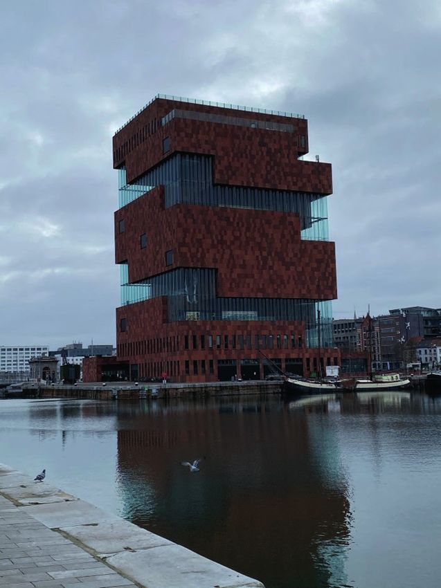
1.3.    Behind the Bilbao effect

Although the concept of the Bilbao effect is world famous, included a
lot of benefit for the city and is even copied in other cities, there are also
more critical voices related to these definitions provided for the term.
In the publication by Heidenreich & Plaza, they state that the given
definitions of the Bilbao effect first of all neglects that the revitalization
of Bilbao was not only inspired by the national policies, but also by
examples of other cities with a similar kind of approach, such as the
regeneration of Glasgow after its year as the European City of Culture in
1990 or Barcelona before the Olympic Games in 1992.

A second remark in this publication is that there is a lot of focus on
the Guggenheim Museum as the key element for the Bilbao effect
and that thereby the fact that the renewal of Bilbao is not only limited
to this building is ignored (Heidenreich & Plaza, 2015). The renewal of
Bilbao consisted of a much larger project implemented in multiple
areas of which the Abandoibarra area, which includes the Guggenheim
museum, is seen as the best example.

     “A creative city cannot be founded like a cathedral in the desert: it
    needs to be linked to and be part of an existing cultural movement.”
                              (Pratt, 2008, p.35)

1.4.    Conclusion

As can be concluded from the definitions stated before, the
Guggenheim museum is seen as the key element of the revitalization
and economic boost of Bilbao and therefore as the most important
element of the Bilbao effect. However, there is more behind this effect
then only the iconic museum building, while the museum is part of a
bigger masterplan to redevelop an entire area in the city of which other
elements contributed to the effect as well.

8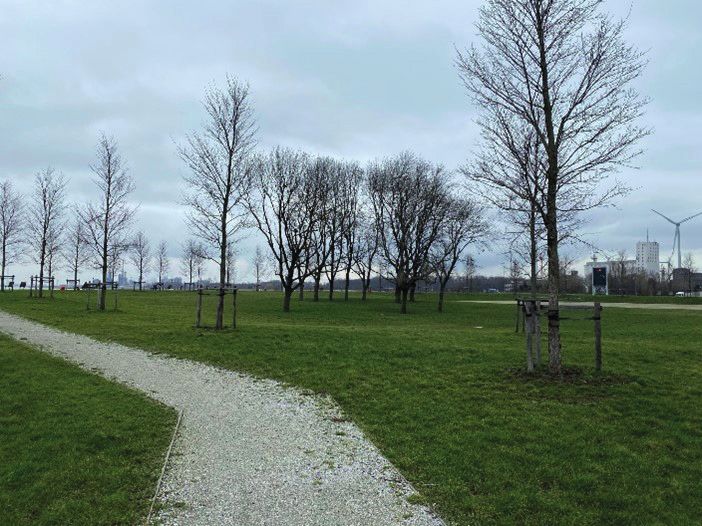
2. The Redevelopment of Bilbao

This chapter will elaborate on the history, context and main concepts
of the masterplan for the redevelopment of Bilbao. Then these
concepts are translated to the Abandoibarra Masterplan to which the
Guggenheim museum relates directly. The use and implementation
of green will be discussed to see how Bilbao made use of green in the
development of their former industrial area.

2.1.   The industrial decline of Bilbao

As a small city from the 14th century, located on the Bay of Biscay in
the northern part of Spain, Bilbao had historically benefited from this
strategic position with access to the ocean and the abundance of iron
deposits. During the 19th and 20th century, Bilbao took advantage from
the availability of water and underwent a big industrialization process
that turned the city into a commercial node, with connections to both
England and the Netherlands. This process made Bilbao into the
economic capital of the Basque Country (Lus-Arana, 2017).

While the shipbuilding industry and other related industries
established themselves in Bilbao next to the steel production, the
industrial tissue of the city kept expanding long after the local iron
resources were exhausted. The settlement of this industry asked
for an exponential growth and in the end transformed the city and
surroundings into a metropolis with one million inhabitants.

However, towards the 1970s, the industries in Bilbao did not adapt
quickly enough to the improving technical standards demanded for
that time. The dockyards became outdated and factories had to close
and the factory buildings and ironworks were abandoned.

During the better days, the steel factory Altos Hornos de Vizcaya
employed around 13.000 workers. After the restructuring of the steel
sector in 1980, the factory still employed 11.000 workers and indirect
jobs related to this factory employed over 40.000 people (Lus-Arana,
2017). However, in the period between 1975 and 1985 , the income rates
ha a enormous decrease in the industrialized areas of the Basque
Countries. During the 1980s, the Altos Hornos de Vizcaya went in an
accelerated process of dismantlement with a lot of early retirements
and the closure of other related smaller companies.

The Spanish Society of Naval Construction, also known as La Naval,
was located a within a few kilometers of the Altos Hornos de Vizcaya
factory. At the same time, La Naval, the company that monopolized the
shipbuilding in Spain since the 1900s, tried to absorb the exceeding
employees from Altos Hornos de Vizcaya, while it also had to deal with
their own inevitable decline.

                                                                          9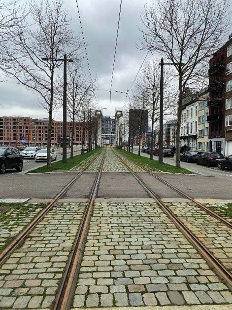
Next to this, in 1985 the large shipyard Astilleros Euskalduna, located in
Nervión river in the heart of the city, closed its doors after a turbulent
year with continuous series of riots and demonstrations of workers
joined by students even resulting in gunfire.

The market share of the shipbuilding industry in Spain grow from 1.2
percent in 1950 to 2.5 percent in 1960 and even 4.7 percent in 1970 it
was ranked as fourth worldwide after Japan, Sweden and Germany.
However, in 1978 these numbers suffered an enormous decline due to
the emergence of other economies. The shipyards got into a process of
decay that rapidly destroyed a huge part of the industrial tissue in the
Bilbao and the area that depended on it.

Due to this decline around the 1970s, the city suffered an extremely
high unemployment rate, up to 25 percent (Plaza, 2007) and many of
these workers and their families left the cities. The ones who stayed,
however, had no work and little perspective for their futures. Next to
this, the industrial area of Bilbao was declined so much that is was in
need of total rethinking and redevelopment.

2.2.   The redevelopment of Bilbao

After the decline of the vital industries and industrial area in Bilbao, the
city was in need to transform into a post-industrial city. On 19 November
1992 the company BILBAO Ría 2000 was set up with the goal of
managing the recovery of the old industrial areas in the city (Bilbao Ría
2000, n.d.). The company is a non-profit organization resulting from
the commitment of all the Public Administrations to collaborate on
this task. Bilbao Ría 2000 was set up with an initial contribution of 1.8
million euros and over time they established a financial equilibrium
without the need to resort to the public budgets of its partners beyond
the made agreements for specific works.

The urban redevelopment consisted of an ambitious process covering
the entire lower area of the Nervión River to configure a metropolis for
the modern age. The redevelopment took into account physical, social
and economic concerns and developed on four main conceptual axis
(Areso, 2017).

The first concept is more related to urban planning and concerns the
external accessibility and internal mobility for the new metropolis.
These developments were determining factors in the attraction of new
business investments and included the expansion of the port facilities,
a new airport and the underground metro system. Next to this, the
roads and railways were improved and the future Intermodal Station
was constructed.

A second concept in the redevelopment is the environmental and
urban regeneration of the area. While this part of Bilbao was an
industrial area before, this regeneration was also needed for the
development of new economic activities. This redevelopment included
the improvement of the infrastructure with focus on reducing the
pollution, cleaning the waterways and expansion of parks and green-
belt structures.

10
The third aspect is the investment in human resources and
technological transformation. Bilbao had to adjust its educational
offerings to the new circumstances. Universities, professional training
units, the relationship between training and employment, post-
graduate training had to be a priority for this.
Lastly, the redevelopment included the boost of cultural activity.
The cultural activities, arts, sports and leisure could determine the
attractiveness of a city and contributed to the image of the city abroad.
Functions related to this improvement are the Museum of Fine Arts, the
Campos Eliseos Theater and Arriaga Theater, the Euskalduna Music and
Conference Hall and city libraries.
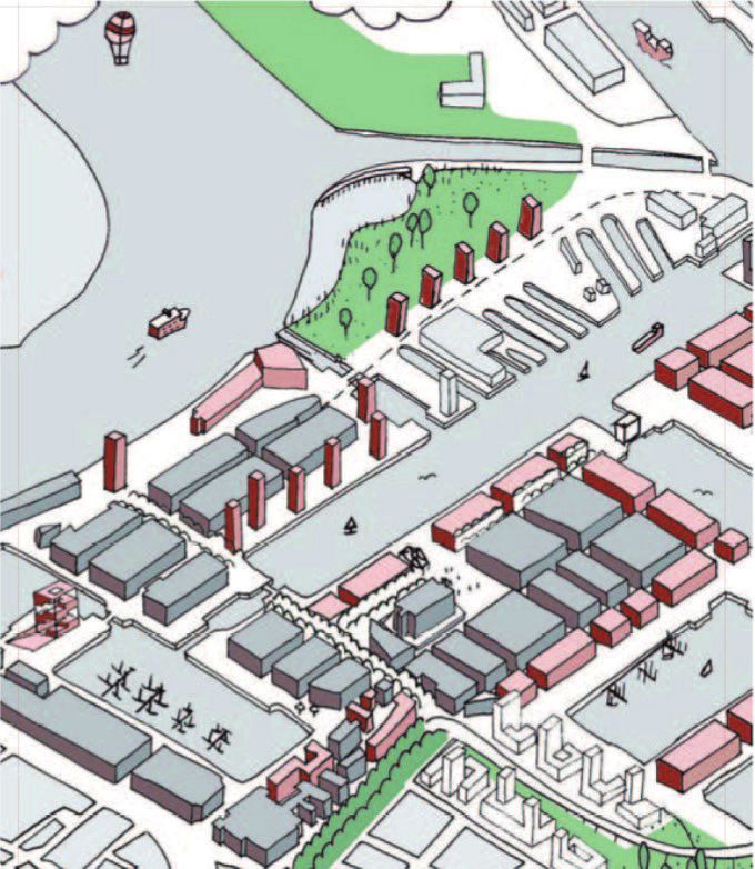
2.3. The Abandoibarra Masterplan
In 1993, the city council of Bilbao organized an international
competition to design the master plan to redevelop the former
industrial area and connect it to the city, the Abandoibarra Masterplan.
A team formed by Cesar Pelli & Associates, Aguinaga & Associates
and landscape and urban design studio Balmori Associates won
the competition for the area that would become the symbol of the
transformation of Bilbao (Gil, 2017). Based on the masterplan (image
2.01), Balmori Associates transformed the former industrial center of
Bilbao.
The Abandoibarra area has been reinvented as an international cultural
district and tourist destination. Two-third of the total 30 hectare area is
dedicated to open space and parks to create public oasis. Next to this,
multiple buildings by master architects as Alvaro Siza, Rafael Moneo,
Cesar Pelli, and Robert A.M. Stern are located in the area. On the edge
of the site the Guggenheim Museum is located. A new tram track is
constructed that runs along the edge of the water on a green lawn. The
masterplan includes three main landscape interventions that define
the broader implementation of green structures, the Campa de los
Ingleses park, the Plaza Euskadi and The Garden That Climbs the Stairs.
The design by Balmori Associates weaved the new developments into
the historic city with an emphasis on the expansion of green space
(Architizer, sd).
2.01
The Abandoibarra
Masterplan
11The main interventions of the Abandoibarra masterplan relate to
the general concepts used for the redevelopment in Bilbao. The first
strategy implies the accessibility towards and in the metropolis. The
masterplan for the Abandoibarra area includes the construction of the
new tram track running through the area and connecting it with other
parts of the city and the central station. The pedestrian and vehicle
traffic are organized along this same axis, the Avenida de Abandoibarra.
The tram runs on a 12 meter wide and landscaped track in the middle
of the avenue. A second intervention to improve accessibility is the
construction of the Pedro Arrupe Walkway (image 2.02), a pedestrian
bridge that connects to the Deusto University. Next to this, another
connection for pedestrians is made to connect the new Paseo de
Abandoibarra with the Deusto Bridge with a spiral staircase (image
2.03) to connect the difference in height between the promenade and
the bridge (Bilbao Ría 2000, sd).
2.02
Pedro Arrupe Walkway
2.03
Deusto Bridge Steps
The investment in human resources and technological transformation
with the adjustment of the educational offerings can be seen in
the Abandoibarra with the implementation of the Bibliotheca de la
Universidad de Deusto, the Paraninfo de la Universidad del País Vasco
and the construction of the office block Torre Iberdrola.
The Bibliotheca de la Universidad de Deusto (image 2.04) is the library
of the University of Deusto and is built on the other side of the Pedro
Arrupe bridge. The library, designed by Rafael Moneo, opened in 2009
and is with nearly a million volumes considered as the most important
library of the Basque country (Bilbao turismo, 2021).
The Paraninfo de la Universidad del País Vasco (image 2.05) is the
assembly room of the university of the Basque Country. The building
is designed by Álvaro Siza, opened in 2010 and is an important lecture 2.04
Bibliotheca de la
building of the university. Universidad de Deusto
2.05
The Torre Iberdrola (image 2.06) is one of the most unique buildings Paraninfo de la
of the area and is conceived as an urban landmark designed by Cesar Universidad del País
Pelli. The tower is 165 meters high and thereby the highest building in Vasco
the northern part of Spain. The total area of 50.000 m2 divided over 41 2.06
floors is all used for offices (Bilbao Ría 2000, n.d.). Torre Iberdrola
12The redevelopment also included the boost for cultural activities in the
area to improve the image of the city in other countries and thereby
attract tourists to the cities. The Guggenheim Museum is the best
example of the implementation of culture for both the Abandoibarra
Masterplan and the redevelopment of Bilbao as a whole. Next to
this the earlier mentioned university buildings designed by renown
architects add to the implementation of culture as well.
2.4. The implementation of green in Abandoibarra
An important concept in the redevelopment of Bilbao is the
environmental and urban regeneration of the area. As mentioned, three
main landscape interventions are implemented in the area that define
the broader use of green in the area as a whole.
The Campa de los Ingleses Park (image 2.07 + 2.08) opened in
September 2011 and is one of the main green spaces in the area for
recreation and walking. The park connects the different heights of the
Ensanche and the Abandoibarra area. The park is situated between
the Deusto Bridge and the Guggenheim museum and surrounds the
new constructed buildings in the area like the University Library, the
Assembly Hall and the Iberdrola Tower.
The park is designed by a team led by Diana Balmori, who co-designed
the entire masterplan, together with RTN Architect after they won an
international competition. The park has a total area of 24.580 m2 of
which almost 20.000 m2 is used for grass. In the park 109 trees and 2.119
bushes and one moss garden are planted (Bilbao Ría 2000, sd).
2.07 + 2.08
Campa de los Ingleses
The second landscaping intervention is the Plaza de Euskadi (image Park
2.09). The plaza connects the Ensanche, which is the section of the city
from the 19th century to the new area of Bilbao, the campus of the
university, the Guggenheim Museum and the Nervión river. The plaza
is surrounded by the Museum of Fine Arts, historic residential buildings
and contemporary buildings, such as a shopping mall, hotels and
library.
The plaza has an oval form with two forms of circulation, a path for
recreation and walking around the perimeter and a dominant central
path that connects the city with the Campa de Los Ingleses park, the
river and the pedestrian bridge to the university.
13The Plaza de Euskadi is designed by Cesar Pelli and opened in March
2011. The plaza covers a total area of 6.600 m2 for which 91 trees were
planted (Bilbao Ría 2000, sd).
2.09
Plaza de Euskadi
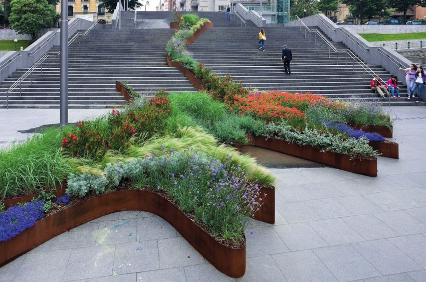
The third part of the landscape interventions is the Bilbao Jardin
also known as the garden that climbs the stairs (image 2.10 + 2.11). In
2009, Diana Balmori was invited to design a garden and she chose to
implement this garden on the steps between two towers designed
by Arata Isozaki that led to the pedestrian bridge over the river. The
garden contains the contrast between native and exotic plants and
the colors contrast with the green grass and grey paving of the stairs
(Architizer , sd).
2.10 + 2.11
Bilbao Jardin
Next to these three landscaping interventions, green has been
implemented in more ways. The Doña Casilda Park (image 2.12) has
been extended and opened in March 2006. The extension now reached
until the residential area adjoining the site. The total area of this
intervention was 30.000 m2 of which the extension of the park occupies
18.559 m2 with 283 new trees and over 700 shrubs (Bilbao Ría 2000, sd).
14Another large scale implementation of greenery is the Ribera Park
(image 2.13) that opened in 2003. The park was the first major finished
work that the citizens of Bilbao and visitors could visit in the area.
The park covers an area of 48.000 m2 and is home to an important
collection of sculptures alongside the Paseo de la Memoria that refer
to the former industrial power of the Abandoibarra area. The park 2.12
Doña Casilda Park
is organized on three terraces connected by ramps and stairs and
includes both grass areas with trees and single standing trees. 2.12
Ribera Park
The interventions mentioned are implementations of larger
green structures in the area. The redevelopment also includes the
implementation of fine meshed green, which is best visible in various
street profiles in the area. As mentioned before, the Avenida de
Abandoibarra (image 2.14) is an important traffic axis. Next to this the
axis is used to implement a green line through the area with the use
of a green area in the middle of the Avenida and trees on the sides.
The area between the Avenida and the Plaza Euskadi, called the
Lehendakari Leizaola is also used for the implementation of greenery
by planting 66 trees.
In March 2003 the Avenida de las Universades (image 2.15) reopened
and during the redevelopment was widened from two to nine meters
over a total length of 646 meters. The refurbished Avenida has a
pedestrian area of 4 meters wide along the water, a 2.5 meter cycle
lane and a two way traffic street. Between the pedestrian area and the
cycling lane a landscaped axis of 2 meters is implemented with grass 2.14
Avenida de
and trees. Abandoibarra
2.15
Avenide de las
Universidades
15The building block grid of the city is continued in the new masterplan and the buildings should also be of similar height as the already existing buildings along the Ensanche. The building typology therefore consists of larger building blocks used for multiple purposes. The open space plan related to this, mainly focusses on the implementation of larger green structures and plazas that follow the organic shapes of the masterplan and river. 2.5. Conclusion The decline of the industrial area in Bilbao was the result of a decline in the shipbuilding industry in the area. Due to this a lot of people became unemployed and left the area and the region was in desperate need of redevelopment. The redevelopment for the industrial areas in Bilbao is based on four main concepts; the improvement of accessibility and internal mobility, environmental and urban regeneration, investment in human resources and the boost of cultural activities. The masterplan for the Abandoibarra area is seen as the best example of the redevelopments in Bilbao and the interventions relate to these four main themes. The masterplan includes three main landscaping interventions that define the broader implementation of green in the entire area; the Campa de los Ingleses park, Plaza Euskadi and The garden that climbs the stairs. Next to this, other existing park structures are extended and new ones implemented. The tram track adds a new green axis in the area. For the environmental and urban regeneration in Bilbao the focus was mainly on the implementation of bigger green structures. This relates to the lay out of the area, which follows the building grid of the city and the mixed-use of these larger buildings. Two-third of the total 30 hectare area of the masterplan is dedicated to open space and parks, so it can be concluded that Bilbao made use of the opportunity of the redevelopment to implement green in a former industrial area that did not have much green. 16
3. The redevelopment of Antwerp

This chapter elaborates on the comparison and the use of the Bilbao
effect in the development for Antwerp. The background and context for
the development of het Eilandje are discussed with the key elements of
the masterplan and the implementation of green in the area.

3.1.   The Bilbao effect in Antwerp

Since the construction of the Guggenheim museum and the
benefits for Bilbao multiple cities tried a similar approach in their
urban redevelopment even with the construction of a museum as
a key element similar to Bilbao. In the publication ‘The Museum
after the Bilbao Effect’, Sanja Rodeš makes the connection between
the Guggenheim in Bilbao and the Museum aan de Stroom (MAS)
in Antwerp. However, this publication mainly focusses on the
iconic architecture of the buildings, while these cities and their
redevelopments have more in common than only the use of the
museum. This chapter will elaborate on the connection between Bilbao
and Antwerp and the link with the Bilbao effect while making use
of an interview with Filip Smits. Filip Smits works at the municipality
of Antwerp in the department of city development. He has been the
project manager for the development of het Eilandje until a few years
ago. Currently he is still involved in the development of het Eilandje in
an advisory function.

While cities tried to copy the elements and results of the Bilbao effect
to their own areas in need for redevelopment, Smits argued that
Antwerp did not copy the Bilbao effect intentionally. However, there are
still elements used in the development for het Eilandje that are similar
to the development in Bilbao and next to this the cities also show
similarities.

Both cities can be regarded as cities of the second line. For Bilbao this
is the case in relation with cities as Barcelona and Madrid and Antwerp
can be seen in the second line of Brussels and even Amsterdam.
Despite this similarity, the redevelopment of Antwerp is done on a
smaller scale compared to Bilbao, while Bilbao is more international
oriented and attracts visitors from all over the world.

Next to this similarity between the cities, the plan for the
redevelopment of the former industrial areas shows similarities as
well. Both masterplans make use of the implementation of multiple
smaller projects to improve the entire area. In both cases, part of these
impulse projects have cultural functions that form a cultural axis that
runs through the area and connects to the city. Also, in both cases
a museum is the most important element of this cultural axis and
implemented to attract more visitors to the city; the Guggenheim
Museum in Bilbao and the Museum aan de Stroom in Antwerp.

                                                                            17
3.2. History of het Eilandje The history of the construction of the area which is called het Eilandje nowadays starts in the tenth century and then already influenced the final structure and layout of the area. After an attack by the Normans, a rampart was constructed around the settlement of Antwerp at that time. Later, in the beginning of the 13th century, this rampart was strengthened and constructed as a stone stronghold wall. This closed off medieval city, with a messy street pattern, was oriented towards de Schelde and the flows (vlieten) that formed the harbor were intertwined in this settlement. Het Eilandje as it known nowadays, is located steps away from this medieval city (Buro5Maastricht, 2004). The 16th century was the Golden Age for Antwerp. In 1540, they constructed a new rampart, updated with the newest defense mechanisms. This rampart became an example for other cities in Europe. During this development, a new part of 25 ha was added to the northern part of the city, de Nieuwstad. Nowadays, the southern part of het Eilandje, de Oude Dokken, are located in the same place. The shapes of this rampart of the 16th century, de Spaanse Wallen, can still be recognized in the shape of de Leien. In 1548, an urbanization plan was set up by Van Schoonbeke to transform the Nieuwstad area into to new economical center by the expansion of the existing harbor. For the expansion three new, east- west oriented, flows were constructed, which influenced the lay-out of the southern part of het Eilandje. Due to religious and political unrest the economic growth of the 16th century stagnated and the need for expansion of the city disappeared. Therefore, a big part of de Nieuwstad remained vacant until the 18th century. The developments of the 16th century are mostly recognizable in the southern part of het Eilandje. Compared to the messy set up of the medieval city, this new part is constructed in a more rational way, which became since then a characteristic element of het Eilandje. In the beginning of the 19th century, Belgium was under the French rule. For military purposes the Bonapartedok and Willemdok were constructed in 1811 and 1813. However, after Napoleon was exiled in 1814, the area with military characteristics changed back into an area with a focus on commercial activities. The port of the city flourished again and the existing infrastructure became insufficient for the growth. The harbor area had to expand both on the inside and outside of the rampart. On the outside the new Kattendijkdok was dug out and had its own connection to de Schelde and on the inside of the wall the port area became six times bigger. Due to these transformations and construction works and improvement of infrastructure during the 1960s, het Eilandje gained its current shape. During the 1920s, the city suffered with overpopulation, as a result of limited damages of the First World War, which led to an anti-urban mindset. Due to new developments and improved mobility, the areas on the edge of the city became much more attractive. The port was also part of this suburbanization process, while the new harbor was placed completely out of the city as a result of the construction of the Albertdok in 1928. 18
During the 1960s the port and industry flourished again and new space
was needed for expansion. So next to the suburbanization, the industry
left the city as well and expanded alongside de Schelde.

‘De structuurschets voor de binnenstad’ of 1973 led to less
suburbanization and made living in the city more attractive again.
It also led to a new evaluation of the built heritage and in the end to
less demolished buildings that are part of the history of the area. This
structure plan was an important step for the redevelopment of the
industrial areas, such as het Eilandje, in the city.

3.3.   Het Eilandje Masterplan

In the beginning of the 1990s the organization ‘Stad aan de Stroom’
is set up and Manuel de Solà-Morales created the first vision for
the development of het Eilandje. However, only in 1996 the city
continued on the plans for the development. René Daniels, who was
the stadsbouwmeester of Antwerp at the time, was assigned as the
project manager for the development. He translated the ideas of the
municipality and by De Solà-Morales into a realistic plan. Together with
some colleagues of his office Buro 5 from Maastricht Daniels set up
‘project bureau Eilandje. In the same year his office was assigned to
design a masterplan for an even bigger Eilandje, which was approved
by the city council in March 2002.

The Masterplan (image 3.01 + 3.02) for the redevelopment of het Eilandje
started with a vision including three main concepts. First of all, the area
has potential to become a new part of the inner city of Antwerp due
to its location between the city and the port. The lay out, structure and
existing buildings are characteristics of the area and serve as a starting
point for the redevelopments (Buro5Maastricht, 2004). The goal was to
create a mixed living and working environment with focus on culture
                                                                              3.01 + 3.02
and recreation, of which the MAS is an example.                               Het Eilandje Masterplan

                                                                                                   19
The second concept is, as mentioned before, that existing characteristics of the area as a result of is history are the basis for the new developments. Important characteristics are the layout of the area, the open spaces and the sightlines, while these are less recognizable in all other parts of the city. Thirdly, the masterplan is designed as dynamic and flexible, so there was, and still is, the possibility to make changes in the implementation if needed in relation with specific areas or changes needed over time. The masterplan is not set up as a goal that should be reached in the end of the redevelopment, but as a strategic border for the development of het Eilandje. Therefore it is also possible to adapt to the unpredictable future with the use of the same masterplan. The first phase of the masterplan distinguishes three areas with their own characteristics. These areas are the area surrounding the Willemdok and Bonapartedok, called the Oude Dokken, de Cadixwijk and the Montevideobuurt. The masterplan was set out to connect these three areas as a whole to both the city and the port, however due to their own characteristics a specific plan is worked out for each area. The Cadixwijk and Oude Dokken became more connected by the expansion of the layout of the building blocks of the Cadixwijk towards the south. The Oude Dokken and Montevideobuurt are connected in two lines. The first axis is the Scheldekaaien, which is the transition area between de Schelde and the two neighborhoods. The Scheldekaaien is developed as a stretched out public square that forms the connection between the city with het Eilandje. The second line is the cultural axis that connects the city and het Eilandje and is based on the ideas of Manual de Solà Morales. This axis runs through the Oude Dokken and Montivideobuurt and connects to multiple cultural functions like the Red Star Line, Montevideoloodsen and the most important building for the connection, the Museum aan de Stroom. The most important axis in the east-west direction is the Londen- Amsterdam axis. This line not only connects the separated areas of the masterplan, but also connects the Scheldekaaien with the park Spoor Noord. The London-Amsterdam axis is designed as a green boulevard with a tram line to improve the connections between the city center, surrounding areas and het Eilandje. 3.4. The implementation of green in het Eilandje Masterplan The use of green was an important element in the redevelopment of het Eilandje. It served for a unique opportunity to design an urban and green structure plan for such a big area. The main challenge for this transformation from a former industrial area into a lively part of the city, was to introduce greenery in a neighborhood that until then did not have green. while housing would become the new main function of the area, green needed to be implemented (Michel-Desvigne- landschapsarchitecten, 2005). The plan for the implementation of green structure consists of five main elements that form one visual whole. 20
The first element of the plan are the groups of trees along the quays
(image 3.03+3.04). This element was developed with the use of a case
study of the Willemdok and an earlier design for the outside spaces. An
analysis of this design indicated the possibilities and limitations of the
areas. Some zones were not suitable for greenery, such as the zones
used for traffic like streets, parking space and the roofs of underground
parking. Alongside the docks zones were planned for pedestrians and
therefore not possible to implement green as well.

In between these unsuitable areas, there are linear strips parallel to
the edges of the docks defined as plant strips that are suitable to plant
trees. One of the sides of the tree groups is always 5 meters and the
other side is determined by the width of the plant strip.

A goal of these tree groups was that they should provide an interesting
green structure both at the time of planting and as well after 20 years
and therefore these tree group is able to evolve over time. At the time
of planting each tree group had a certain leaf mass by a dense planting
of a few permanent trees combined with temporary trees. Over time
these temporary trees are thinned out and in the end removed, so only
the permanent trees remain. The permanent ones are planted in a
specific place in all the tree groups and in the end form the final green
structure for the open space.

The green structure plan provides three options for the soil of the tree
groups along the quays. The first and preferred option are cover plants,
while they provide for a green soil and have minimal maintenance. If
access to the tree group is needed, the soil is paved with green edges.
The third option is planting ornamental grass. While this option asks for
more maintenance, it is only applied in some specific situation to give
the layout of the tree group some additional value.

                                                                             3.03
                                                                             Section and plan of tree
                                                                             group along quays

                                                                             3.04
                                                                             Tree group along quays

                                                                                                   21
The second element of the green structure plan is the ‘street tree 3.05
group’ and in applied to the inner streets of the areas (image 3.05+3.06). Section and plan of tree
Also for this green the structure the areas not suitable for planting are group in inner streets
defined as the zones for streets and parking space and the paving for 3.06
pedestrians alongside the buildings. Tree group in inner
streets
The tree groups in the inner streets are integrated in the parking
strips and therefore the distance between two groups will always be a
multiple of the length needed for one parking place. This combination
serves for flexibility in the layout of parking and greenery, but the
existing entries to buildings and the desired number of parking places
are the basis for the final structure of the combination. Next to this,
some places are left out of the parking and tree groups to provide
space for pedestrians to cross the street.
The tree groups for the streets are, in contrast to the groups of trees
along the quays, not placed in a fixed geometrical pattern. In this case
only two of the tree earlier mentioned soil options are implemented,
namely the planting with cover plants and the paving with green edges
if accessibility is needed.
The temporary landscapes are the third element of the green
structure plan for het Eilandje. These temporary landscapes are used
to implement greenery on plots on which in a later phase of the
development the buildings are built.
There are three possibilities for the temporary landscapes (image 3.07)
with a goal to get a maximum result with minimal costs. The three
options are combined to create parking spaces, by the integration of
the existing parking spaces in a green setting, the option for as much
public space as possible and the option for a maximum green area on
the plot.
223.07
Options for temporary
While these green structures will be removed in the end and biggest landscapes
part of costs for the construction of green normally disappears 1. Parking
2. Public space
underground, a system was developed to place the green on top of 3. Green space
the existing infrastructure instead. A layer 60 to 80 centimeters of leaf
mould is placed on top of the existing infrastructure to make it possible
to plant flowers and ornamental grass.
The fourth element of the implementation of green are the park
structures. For the larger green parks a case study was set up for a park
in the Cadixwijk perpendicular to the Kattendijkdok. With the parks a
new type of green structure is added to het Eilandje and green reserves
are created. The structure of the parks is based on the larger parks
created in America in the 19th century. The parks are densely planted,
but still provide open spaces. The trees are planted on parallel lines
with six meter distance in between and have a varying density on each
line. Thereby sightlines are created that enable a view both towards the
dock and the surrounding buildings through the park.
The mentioned case study in the Cadixwijk is called the Schengenplein 3.08 + 3.09
(image 3.08 + 3.09) designed by PTArchitecten. The first phase of the Schengenplein
park was completed in 2017 and in 2021 the construction of the second Cadixwijk phase 1
part along the Kattendijkdok will be constructed. The park has a total 3.10
area of 17.360 m2 and is situated on both sides of the Kattendijkdok- Plan Schengenplein PT
Oostkaai, which also includes a tram track (image 3.10). Architecten
23The fifth element of the green structure is the avenue planting. This
includes the row planting of for example plane trees along the avenues.
This part of the green structure plan is frequently used throughout the
city and therefore is a connection element between the city center and
het Eilandje.
These five elements provide for most greenery in het Eilandje, but does
not include all the implementation of green. As mentioned before,
the Londen-Amsterdam axis is an important line from east to west
connecting the Scheldekaaien with park Spoor Noord. On this axis, a
tram track is embedded in a green central area with trees along the
sides (Image 3.11).
The Park Spoor Noord (Image 3.12+3.13) is another example of large
implementation of a green park structure in the area. The park is
constructed on a former railway yard that fell into disuse in the middle
of the 1990s (AG Vespa, sd). The park covers an area of 24 ha, with a
length of 1.6 kilometers. The intention of the park was to improve the 3.11
Tram track embedded
living quality for the dense neighborhoods with a lack of open space in green
adjacent to the site. The park is set up with a lot of open space and
grass which serve for recreation and activities. Next to this various 3.12 + 3.13
Park Spoor Noord
playgrounds, sport fields and a skate park are implemented.
Next to the mentioned avenue planting, the materialization and use
of greenery species is another connecting element between the
multiple parts of het Eilandje and the area with the city. Filip Smits
mentioned that the trees and plants are mainly native species and
the materialization is kept in line with the other parts of the city for
maintenance reasons. However, the green structure for het Eilandje
included a little more freedom then other parts of the city. The
materials and vegetation species are mentioned in the implementation
of green before, such as the cover plants, ornamental grasses and the
use of paving with green seems.
The first phase of the masterplan of het Eilandje includes a lot of
housing and therefore the focus was on the implementation of fine
meshed green, such as the tree groups along the quays and streets,
with a few larger public green structures. This way of implementing
green makes this part of the city more attractive for housing.
The second phase of the masterplan, which includes
Droogdokkeneiland and Mexico-eiland, will also include more
commercial functions and therefore the focus on this part will be more
on the implementation of larger green structures than on the fine
meshed green as seen in phase one. The second phase is based on
the same masterplan and green structure plan. Due to the flexibility
24of these plans, it is possible to adapt for the various phases in the
redevelopment of the masterplan and even adapt to the rising demand
of green in cities (Smits, 2021).
The second phase of the masterplan is still under construction and
uses the implementation of larger green structures. An example of this
larger park structure is the plan for the Droogdokkenpark (Image 3.14). 3.14
A first part of the park opened in 2018 and covers an area of 2 ha (Image Plan Droogdokkenpark
3.15 + 3.16). After completion the park structure will cover 15 ha (JaTi,
3.15 + 3.16
2016). There will be less focus on the small meshed green in this phase. Droogdokkenpark
3.5. Conclusion
It became clear that Antwerp did not intentionally copy the Bilbao
effect to their own city. However, next to the use of a museum as the
key element for the cultural boost in the area, the approaches show
more similarities. Next to the museum, the masterplans use the
implementation of multiple smaller project to define a cultural axis.
On the other hand, redevelopment for Antwerp is considered to be
on a smaller scale, while Bilbao is more international oriented for the
attraction of tourists.
Due to the flourishment of the harbor in Antwerp, it needed an
expansion which was only possible by replacing the port to a new
location. This combined with a new anti-urban mindset let to a decline
of the industrial area. The Structuurschets voor de Binnenstad made
living in the city more attractive again and was an important step for
the redevelopment of the industrial areas.
The vision for the redevelopment of het Eilandje consists of three main
concepts; the area has potential to become a new part of the city due
to its location, the layout and existing buildings are the starting point
for the masterplan and the masterplan is designed to be flexible and
dynamic.
The implementation of green was an important element for the
redevelopment, while it served for a unique opportunity to design an
urban and green structure plan for such a big area and introduce green
in a former industrial area.
Green is implemented in five main ways; The tree groups along the
quays, the tree groups in the inner streets, the temporary landscapes,
park structures and avenue plantings.
The last element, combined with the materialization, is the connecting
element between het Eilandje and other parts of Antwerp.
25The first phase of the masterplan for het Eilandje handles the neighborhoods that are mainly meant for housing. Therefore, the implementation of fine meshed green, so the various types of tree groups, is best visible in this area. The park structures can be seen in the Schengenplein and the Park Spoor Noord. The second phase includes more commercial function and the focus for this area is on the implementation of larger green structures and less on the fine meshed green. 26
Conclusion

Bilbao and Antwerp both had different reasonings for the
redevelopment of their industrial port areas. In the case of Bilbao a
decline of the shipbuilding industry was the main reason for the decline
of the area, while in Antwerp the flourishment of the harbor and a
need for expansion led to a replacement of the harbor area and an
abandoned industrial area on het Eilandje.

Both masterplans show similarities in their approach, without the
intention of the city of Antwerp to copy the Bilbao effect directly. Next
to the use of a museum as the key element for the cultural boost of
the area, both masterplans make use of multiple smaller projects to
improve an entire area.

On one hand, similarities can be seen in the elements used for
the implementation of green in both areas, such as the tram track
embedded in green, the use of park structures and the use of fine
meshed green. However, there are also difference in the use of green
in the areas. The Abandoibarra masterplan includes larger building
blocks with mixed use functions in an open structure. Therefore the
focus for greenery is on the implementation of new park structures and
expanding existing ones and less on the fine meshed Green. The first
phase of het Eilandje masterplan is implemented in neighborhoods
that are mainly used for housing. In these areas the focus is more on
the implementation of a lot of fine meshed green with a few larger
park structures to improve the living quality in the neighborhoods.
The second phase of the masterplans shows more similarities with the
approach in Bilbao while it consists of more commercial functions with
a focus on implementing larger green structures.

In the end it can be concluded that both cities took their chances with
the redevelopment of these urban areas and implemented green in
areas that had a lack of green in their previous uses.

                                                                            27
Bibliography
AG Vespa. (sd). Park Spoor Noord. Retrieved Guggenheim Bilbao. (2018). Introduction.
from AG Vespa: https://www.agvespa.be/ Retrieved from Guggenheim Bilbao
projecten/park-spoor-noord#over Corporate: https://www.guggenheim-
bilbao-corp.eus/en/bilbao-guggenheim/
Architizer . (sd). THE GARDEN THAT CLIMBS introduction-and-history/
THE STAIRS / BILBAO JARDIN 2009.
Retrieved from Architizer: https://architizer. Heidenreich, M., & Plaza, B. (2015).
com/projects/the-garden-that-climbs-the- Renewal trough Culture? The Role
stairs-bilbao-jardin-2009/ of Museums in the Renewal of
Industrial Regions in Europe. European
Architizer. (sd). Bilbao Waterfront Planning Studies, 23:8, 1441-1455, DOI:
Abandoibarra Master Plan. Retrieved from 10.1080/09654313.2013.817544.
Architizer : https://architizer.com/projects/
bilbao-waterfront-master-plan-and-urban- JaTi. (2016, January 29). Zo gaat het
design/ nieuwe park in de Scheldebocht eruitzien.
Retrieved from GVA: https://www.gva.be/
Areso, I. (2017). Bilbao’s Strategic Evolution: cnt/dmf20160129_02097920
The Metamorphosis of the Industrial
City. Retrieved from Mas Context: https:// Lus-Arana, L. (2017). Behind the Bilbao
www.mascontext.com/issues/30-31- Effect: An overnight success that took 20
bilbao/bilbaos-strategic-evolutionthe- years. Zaragoza : University of Zaragoza.
metamorphosis-of-the-industrial-city/
Michel-Desvigne-landschapsarchitecten.
Bilbao Ría 2000. (sd). Actions Abandoibarra. (2005). Groenplan Eilandje-Antwerpen.
Retrieved from Bilbao Ría 2000: https:// Antwerpen: Antwerpen Eilandje.
www.bilbaoria2000.org/en/actions/
abandoibarra/ Plaza, B. (2007). The Bilbao effect
(Guggenheim Museum Bilbao). University
Bilbao Ría 2000. (sd). What is Bilbao Ría of the Basque Country.
2000. Retrieved from Bilbao Ría 2000:
https://www.bilbaoria2000.org/en/bilbao- Rodeš, S. (2014). The Museum after the
ria-2000/what-is-bilbao-ria-2000/ ‘Bilbao Effect’. Proceedings of the Society of
Architectural Historians, Australia and New
Bilbao turismo. (2021). New Architecture - Zealand; 31, Translation, edited by Schnoor,
Deusto University Library. Retrieved from C. (Auckland, New Zealand; SAHANZ and
Bilbao Bizkaia: https://www.bilbaoturismo. Unitec ePress; and Gold Coast, Queensland:
net/BilbaoTurismo/en/new-architecture/ SAHANZ), 321-330.
deusto-university-library
Smits, F. (2021, February 11). Interview
Buro5Maastricht. (2004). Masterplan masterplan en groenvoorziening Eilandje
Eilandje-Antwerpen. Antwerpen: Antwerpen . (T. d. Gouw, Interviewer)
Antwerpen Eilandje.
Forster, K. W. (1998). Frank O. Gehry:
Guggenheim Bilbao Museoa. Stuttgart and
London: Edition Axel Menges.
Gil, I. (2017). Setting Up New Relationships
Between City and Nature. Retrieved from
mascontext: https://www.mascontext.
com/issues/30-31-bilbao/setting-up-new-
relationships-between-city-and-nature/
28Illustration credits
0.01. (n.d.). [Guggenheim Museum Bilbao]. 2.09. Bilbao Ría 2000. (n.d.). [Plaza de
[Photograph]. Guggenheim Bilbao. https:// Euskadi]. [Photograph]. Bilbao Ría 2000.
www.guggenheim-bilbao.eus/en/the- https://www.bilbaoria2000.org/actuaciones/
building abandoibarra/plaza-de-euskadi/
0.02. De Gouw, T. (2021). Museum aan de 2.10. Baan, I. (n.d.). Bilbao Jardin 2009.
Stroom. [Photograph]. [Photograph]. Architizer. https://architizer.
com/projects/the-garden-that-climbs-the-
2.01. Balmori Associates. (2012). stairs-bilbao-jardin-2009/
[Abandoibarra Masterplan]. [Illustration]
Balmori. http://www.balmori.com/portfolio/ 2.11. Baan, I. (n.d.). Bilbao Jardin 2009.
abandoibarra-masterplan [Photograph]. Architizer. https://architizer.
com/projects/the-garden-that-climbs-the-
2.02. Bilbao Ría 2000. (n.d.). [Pedro Arrupe stairs-bilbao-jardin-2009/
Walkway]. [Photograph]. Bilbao Ría 2000.
https://www.bilbaoria2000.org/en/actions/ 2.12. Bilbao Ría 2000. (n.d.). [Doña Casilda
abandoibarra/pedro-arrupe-walkway/ Park]. [Photograph]. Bilbao Ría 2000.
https://www.bilbaoria2000.org/en/actions/
2.03. Bilbao Ría 2000. (n.d.). [Deusto Bridge abandoibarra/extension-of-dona-casilda-
steps]. [Photograph]. Bilbao Ría 2000. park/
https://www.bilbaoria2000.org/en/actions/
abandoibarra/deusto-bridge-steps/ 2.13. Bilbao Ría 2000. (n.d.). [Ribera Park].
[Photograph]. Bilbao Ría 2000. https://www.
2.04. Bilbao Ría 2000. (n.d.). [Bibliotheca de bilbaoria2000.org/en/actions/abandoibarra/
la Universidad de Deusto]. [Photograph]. ribera-park/
Bilbao Ría 2000. https://www.bilbaoria2000.
org/actuaciones/abandoibarra/biblioteca- 2.14. Bilbao Ría 2000. (n.d.). [Avenida de
de-la-universidad-de-deusto/ Abandoibarra]. [Photograph]. Bilbao Ría
2000. https://www.bilbaoria2000.org/
2.05. Bilbao Ría 2000. (n.d.). [Paraninfo de la actuaciones/abandoibarra/avenida-de-
Universidad del País Vasco]. [Photograph]. abandoibarra-y-l-leizaola/
Bilbao Ría 2000. https://www.bilbaoria2000.
org/actuaciones/abandoibarra/paraninfo- 2.15. Bilbao Ría 2000. (n.d.). [Avenida de
de-la-universidad-del-pais-vasco/ las Universidades]. [Photograph]. Bilbao
Ría 2000. https://www.bilbaoria2000.org/
2.06. Bilbao Ría 2000. (n.d.). [Torre Iberdrola]. actuaciones/abandoibarra/avenida-de-las-
[Photograph]. Bilbao Ría 2000. https:// universidades/
www.bilbaoria2000.org/actuaciones/
abandoibarra/torre-de-oficinas/ 3.01. Buro 5 Maastricht. (n.d.). [het Eilandje
Masterplan]. [Illustration]. Antwerpen
2.07. Bilbao Ría 2000. (n.d.). [Parque Campa Eilandje. Masterplan Eilandje
de los Ingleses]. [Photograph]. Bilbao
Ría 2000. https://www.bilbaoria2000.org/ 3.02. Buro 5 Maastricht. (n.d.). [het Eilandje
actuaciones/abandoibarra/parque-campa- Masterplan]. [Illustration]. Antwerpen
de-los-ingleses/ Eilandje. Masterplan Eilandje
2.08. Bilbao Ría 2000. (n.d.). [Parque Campa 3.03. Michel Desvigne Paysagiste. (n.d.).
de los Ingleses]. [Photograph]. Bilbao [Tree groups along quays]. [Illustration].
Ría 2000. https://www.bilbaoria2000.org/ Antwerpen Eilandje. Groen Plan Eilandje
actuaciones/abandoibarra/parque-campa-
de-los-ingleses/ 3.04. de Gouw, T. (2021). Tree group along
quay. [Photograph].
29You can also read